tommy jack property - british columbia
TRANSCRIPT

GEOLOGICAL, GEOCHEMICAL AND PROSPECTING REPORT
ON THE
TOMMY JACK PROPERTY
Consisting of the TJ-lto4,TJ8,9andlO,TJ-llto16
Mineral Claims (48 Units)
OMINECA MWWG DMSION
Lat. 56” 07’ N Long. 127’ 37 ‘ W N.T.S. 094D04E
Prepared for:
Gold City Industries Ltd.
By:
Paul Cowley, P.Geo. and Alan Raven
December 2002
TABLE OF CONTENTS
V SUMMARY OBJECTIVES INTRODUCTION LOCATION, ACCESS, PHYSIOGRAPHY CLAIM DATA HISTORY OF THE PROPERTY GEOLOGY
Regional Geology Property GeoIogy structure Mineralization Ice Movement
WORK PROGRAM Work Program Geochemical Sample Preparation and Analyses Detailed Prospecting and Geological Mapping Trenching
CONCLUSIONS AND RECOMMENDATIONS REFERENCES
List of Tables
I Table 1: Claim Information Table 2: DescriDtions of Bedrock Exaosures Table3: : Rock S‘ample descriptions -
Figure 1: Figure 2: Figure 3: Figure 4: Figure 5: Figure 6: Figure 7: Figure 8: Figure 9:
List of Figures
Locatkm and Access Map Claim Map Regional Geology Index for Bedrock Exposures Index for Detailed Trench Maps Detail Map No. 1 Detail Map No. 2 Detail Map Nos. 3 and 5 Detail Map No. 4
Page No. I 2 2 2 4 6 6 6 8 8 9 9
IO 10 10 10 12 21 23
4 12 15
3 5 I
11 13 17 18 19 20
APPENDIX I Analytical Results
APPENDIX II Statement of Costs
APPENDIX III Statement of Qualifications

SUMMARY
The Tommy Jack property, under option to Gold City Industries Ltd., is composed of 48 claim units. The property is !sitoated 95 kilometres north of Hazelton, B.C., in the Atna Range of the Skeena Mountains, near the confluence of Tommy Jack Creek with the Sicintine River.
The Tommy Jack property in conjunction with the adjoining Warren ground covers a 2 x 3.5 km zone of pervasive carbonate alteration. Within this zone are widespread gold-silver-lead-zinc- bearing quartz-carbonate veins in shears and stockworks in Bower Group sedimentary rocks and in granodiorite (dacite) dykes and sills. The nature of the mineralization is compared to the Silver Standard Mine, 85 kilometres to the south (past production of 203,839 tonnes containing 463,000 grams of gold and 236,000,OOO grams of silver). However, gold mineralization found to date in float on the Tommy Jack appears to be of significantly higher gold tenor than at the Silver Standard Mine.
Work completed by Intertech Minerals in 1989, while in a joint venture with Noranda Exploration Ltd., inclulded 14.1 kilometres of grid, geochemical sampling, geophysical surveys and geological mapping. This work generated a number of gold and multi-element soil anomalies to the southwest and s,outheast of the area worked by Noranda. Several strong VLF anomalies were also found to correlate with the general southwest trend of the geochemical anomalies. The targets generated by the Intertech work are now completely covered by the current Tommy Jack property, The highest grade gold values found to date (2.2 ozit gold) are from float found in the vicinity southeast of the Noranda study area. The work done by Raven (1995) further extended the geochemical anomalies, particularly east of Unnamed Creek.
In July 2002, Gold City Industries Ltd. conducted a sixteen day prospecting, mapping, trenching and sampling program in an effort to locate bedrock sources of the high grade gold mineralized float in its creeks. The detailed prospecting traverses and geological mapping located new exposures, both miner,alized and barren, in areas that were thought to be relatively covered by overburden. A new quartz stockwork zone (19230N 20840E Intertech) was exposed, and although it did not carry significant gold values, it proved the existence of significant quartz development on the property. Prospecting in the north and north-east areas of the property resulted in additional discoveries of mineralized float. The sedimentary beds in this area were found to dip to the east. The easterly dip of the sediments requires a re-evaluation of the Noranda drilling in the area. Since the majority of the Noranda holes were drilled to the east, holes may have poorly tested targets. The relatively high values of mercury, arsenic and silver with sporadic gold values hosted by altered felsic intrusive and sedimentary rocks with varying degrees of silicitication and quartz veining appears to indicate the upper portion of an epithermal system. The hand trenching carried out during this program over soil anomalies proved useful in exposing bedrock in the areas of thin overburden where quartz veins was found.
Although bedrock sources of the high precious metal float material were not found, the results of the work conducted dluring the 2002 season are encouraging. The program confirmation that further detailed prospecting and geological mapping can locate new areas of mineralization. Trenching, prospecting and sampling should continue on the Tommy Jack property. Geophysical and soil surveys should be expanded and detailed over anomalous area.
-l-

OBJECTIVES
The objective of the 2002 program was to locate bedrock sources of the high grade precious metal float mineralizati~on on the property. In this vein specific strategies and tasks involved:
1, To further investigate the origins of the soil anomalies and the transported high grade floats in light of the confirmation that the direction of the last ice movement was southerly (uphill),
2. To hand trench of some of the SP anomalies developed by Raven during earlier work programs in order tmo determine their source,
3. To prospect, map a:nd sample any newly discovered exposures of bedrock, 4. To detail prospect soil anomalies defined by Noranda and Intertech in the central and
northeast areas to locate additional exposures of bedrock with the particular goal of determining the attitude of the underlying sedimentary rocks.
INTRODUCTION
The Tommy Jack property covers widespread gold-multi-element soil anomalies, VLF and self- potential anomalies occurring in Bower Group sedimentary rock that are intruded by dacite dykes and sills. This ground is part of the former large claim group (139 units) held under option by Noranda in a joint ‘venture with Gold Cap, and then Intertech Minerals (1986 to 1989). The “Warren” ground that atdjoins the Tommy Jack property on the north and west was where most of the Noranda drilling has taken place but a much larger area (139 units) was the subject of preliminary exploration programs. These programs consisted of geochemical, geophysical geological surveys that delineated a much larger area than that covered by the “Warren” ground. The anomalies, soil and geophysical, have not been fully defined and need much more work to determine their merits.
The purpose of this rezport is to summarize the results of the fieldwork conducted in 2002 by Gold City Industries Ltd. The 2002 season’s work consisted of geological mapping, sampling, hand trenching and detail prospecting. The report summarizes the previous work carried out by Noranda. Intertech and Raven.
LOCATION, ACCESS, PHYSIOGRAPHY The Tommy Jack property is situated 95 kilometres north of Hazelton in the Omineca Mining Division (Figure No. 1). The property lies immediately to the south of the confluence of Tommy Jack Creek with the Sicintine River, which in turn flows into the Skeena River. The property is centered at Lat. 56” 07’ N Long. 127’ 37 ‘ W on map sheet N.T.S. 094D04E.
Access is by helicopter (approximately 1 hour) from Smithers. There are presently new logging roads being built into t:he immediate area. Currently, the closest road is about 10 kilometres to the south of the property.
The property is in the .Atna Range of the Skeena Mountains. The slopes are gentle to moderately steep with elevations r,anging from 1140 to 1760 metres. A heavy virgin forest growth of balsam fir, spruce and hemlock covers most of the claim area up to 1500 metres elevation, above which heather, scrub fir, grass-covered areas and talus predominate.
-2-

c
LOCATION MAP Figure #l
it? 00
JACK CRE PEPTY
c

CLAIM DATA
The Tommy Jack property comprises 48 claim units (Figure 2). All claims are owned 100% by Alan Raven and under option to Gold City Industries Ltd. Claim information is presented in Table 1 below.
Table 1: Claim Information TENURE STATUS TAG UNITS
NT1MRF.R Good standing NUMBER ^^^_ ^ ^. I . . ^^ _ ̂ _ _ 1
_. -_.--__ 370954 ZUU>-uct-UI I 61836XM 370955 ^,,-* - -. ,...^,“.<
370956
I 6135X 1 ZU ,^?..?. <I
2005-s 2005~Sept-I ---- - ’
LUU3-uct-“I bL3413M I
2005-act-01 126267 I8 ept- 16 698873M 1
‘6 698814M 1 Luussepr-16 698875M 1 7005~Sept-16 698876M 1
.^_ - ‘6 698877M 1 ,wu>+epr-16 698878M 1
389996 _. 2OU5-Sept-I -“-- - ’
Geological, Ccoehemical & Prospecting Rrpart an the Tammy Jack Property -4-

----.- --
\ I I + ./
. ‘V ,y \ ~\’ Figure #2
\ I (”
HISTORY OF THE PROPERTY
1964-65: Canex A’erial Exploration
1984: Lome Warren staked property.
1984-85: Property optioned by Noranda; conducted geological and geochemical surveys.
1986-87: Option continued and additional ground staked NorandafGold Cap JV; program of
geological, geochemical, geophysical surveys with drilling carried out on the “Warren”
ground.
1988.89: Option continued with NorandaIGold Cap/Inter&h JV; conducted geological,
geochemical and geophysical surveys on the “Raven” ground, new targets generated.
1989-1995: Property idle but in good standing. Option with Warren dropped.
1995: Raven acquired 19 units as some of the ground covered by the new targets as ground
lapses; conducted ,a geological, geochemical and prospecting program.
1996: Raven acquired 6 units as additional ground lapses (Warren also acquires adjoining
claims).
1999: Raven acquired 24 units (which include 6 units staked in 1995) to cover target areas;
conducted a geological, geochemical, geophysical surveys and prospecting program.
2001: Raven acquired 6 units on the north boundary; conducted a geological mapping,
sampling, prospecting and hand trenching program.
Approximate total expenditures on exploration in the immediate area to date is $675,000.00
Note: The majority of the NorandaIGold Cap monies (drilling) were spent on Warren’s ground that adjoins the Tommy Jack property on the north and west with the most of the remainder spent on what is now the “Raven” ground. (TJ series of mineral claims).
GEOLOGY
Regional Geology The Tommy Jack Creek property lies in the Intermontane belt, one of the five major subdivisions of the Canadian Cordillera (Figure 3). The belt consists of Mesozoic volcanic and sedimentary rocks and is bounded on the east by the metamorphic rocks of the Omineca Belt and on the west by the Coast Crystalline Belt.
The rocks underlying the claim area are part of a thick assemblage of marine and non-marine sediments composed of shale, siltstone, sandstone and conglomerate (Figure 2). The assemblage, referred to as the Bower Lake Group, was deposited in a broad basin (Bower Basin) at least 200 kilometres wide and 300 kilometres long. This basin is interpreted by Eisbacher (1977) to be a marginal basin dewloped along the continental margin, open to the west and filled with sediments derived from a tectonically thickened welt in the east and from the older terranes and volcanic chains on the west. Subsequent sea floor spreading and subduction resulted in 1) the
Geological, Gcaehemical & Prospecting Report an the Tommy Jack Property -6-

GE&AL GEOLOGY
of the
SkTtjERS.HAZELTON
WCONNELL CR&K MAP-AREAS
LEGEND
Tertiary (Paleocene to Miocene)
P
a OolSl Lake Cr;d Endrko Groups
&>‘. .
y Lower Cretaceous Olauterivian) to Eocene
m Skecna Md Surtut Grows
Middle toUpper Jurassic(Bathonian to OxfordiarJ
= Bowser Lake G&p,
Lower to Middle Jurassic(Sinemurian io Callovian)
m Hazelton Grow
upper Triassic to Lower Jurassic
Intrusive Rocks
Upper Triassic
m TaLla Grow
Y. 111.
O.*.cC.
REGIONAL GEOLOGICAL SEFTlNG OF THE
After Tibper and Richards (1974) TOMMY JACK PROPERTY

welding of the older volcanic-plutonic terranes onto the continental crust and 2) uplift and deformation of the rodks of the Bowser Basin.
Intrusive into the Jurassic Bowser Group sedimentary rocks are a Cretaceous series of stocks and small batholiths of porphyritic granodiorite and quartz monzonite termed the Bulkley Intrusions. They lie in a belt 80 kilometres wide and 300 kilometres long, and include a cluster of intrusions in the Atna and Sicintine Ranges in the north and extend southward to include the Quanchus Intrusions in the Whitesail Lake area. The Tommy Jack Creek property is ten kilometres north of the known northern limit of this belt.
The Bulkley Intrusions have a number of common characteristics including:
I) Cretaceous age (70 to 84 million years), 2) high level characteristics, 3) host to a number of important copper-molybdenum and molybdenum-tungsten deposits (Carter, 1981) such as Mt. Tomlinson and Glacier Gulch, and, 4) host to a number of important precious and base metal deposits such as the Silver Standard and Rocher Deboule Mines. both near Hazelton.
Property Geology The Tommy Jack property is on the eastern edge of the Bowser Basin.
The property is underlain by the Bowser Sediments that in the claim area consist of interbedded sedimentary elastics; siltstone, arkosic sandstone, shale and argillite with minor conglomerates. There are exposures of siltstone and sandstone throughout the property. Minor conglomerate was encountered only by several of the drill holes in the area. These beds are gently folded with a generally westward dip and exposed on the East Scarp of Moret Ridge. The sedimentary units are further deformed by a series of fault zones on the property resulting in an east dip on the eastern boundary of the property.
The sediment package is intruded by a felsic unit of the Cretaceous Bulkley Intrusive Suite(?). The field term used is dacite. Multiple intersections of the dacite in the drill holes suggest that there are multiple dyk#es within each of these fault zones (dyke swarms) or that intense faulting has broken single dykes into small sections. The dacites have pervasive sericite and carbonate alteration. The mafic minerals alter to chlorite.
structure
Extensional tectonics Igenerated multiple sub-parallel faults in a northwest to northerly direction as well as faults in northeast to easterly direction. The northwest to northerly faulting dropped each block as one goes from west to east. This interpretation is based on drill sections, air photo lineaments and topography. There are a series of sub-parallel faults with a NNW strike that cross the property and are sub-parallel to or a splay of the major Sicintine fault zone that is located just to the east of the property. There are also indications of fault zones at almost right angles to the main fault zone as indicated by the drainage pattern of the bottom of Unnamed Creek, the strike of a dacite dike in Unnamed Creek and air photo lineaments on the southeast corner of the area. The fault mapped by Allen @NE trending) goes from the headwaters area of Beaver Creek towards the area of Noranda’s most concentrated drilling. This NNE trending fault (Allen’s) may also be the reason for the fragmentation and deflection of the soil and VLF anomalies in the upper area of Beaver Creek. These fault zones provided conduits and areas of weakness for the
Geological, Geachemied & Prospecting Rqmrt on the Tommy Jack Property -s-

penetration of the intrusive bodies and the mineralizing solutions. Multiple episodes of fracturing resulted in the rock units becoming receptive to mineralization in both the sediments and the intrusive bodies,
There is a possible uplift of one of the central blocks as indicated by a circular feature expressed on the air-photo. This may be an expression of a buried intrusive from which the dacite dykes may have originated and/or from which the mineralizing fluids may have derived.
Mineralization Mineralization on the property consists of pyrite, arsenopyrite, galena, sphalerite, tetrahedrite and chalcopyrite, primarily in quartz or quartz-carbonate altered rock. The mineralization is related to dykes and/or faults hosted by veins, veinlets and/or stockworks and carries values in gold and silver. The alteration consists of quartz-carbonate (ankerite, calcite, dolomite) sericite and chlorite (matic minerals in the granodiorite dykes). The dykes themselves show alteration (clay minerals, carbonate and sericite) and contain stockworks of mineralized quartz. The sandstones, being more permeable:, show the greatest degree of carbonate alteration with ankerite, calcite and quartz-carbonate forming veins and fracture fillings. The carbonate alteration zone mapped to date is approximately :2 km. by 3.5 km. and open to the southeast. In Allen’s report for Intertech (1989) his statistical analysis indicates that there are at least two populations of mineralization, thus suggesting at least two mineralizing pulses and possible overprinting of alteration/mineralization.
The quartz and quartz/carbonate veining is multi-directional in both the sediments (sandstone and siltstone) and the dacite dykes. The data from previous drilling supports the interpretation that this veining occurs within broad fault zones within all rock types that the structures penetrate.
Historically, (Noranda/Intertech/Raven) there have been many rock samples, primarily floats but suspected of very local origin, that are of excellent precious metal grade found throughout the property. The grades range from 0.2 to 2.1 oz/ton gold and 0.3 to 74 o&on silver. These rocks are usually quartz and sulphide rich but the quartz can be sulphide poor and still carry excellent gold grades (Noranda/Intertech data). The floats can be found in most drainage patterns within the target areas as well as scattered within the overburden. These floats are found in an area from just west of Beaver Creek to east of Unnamed Creek, a distance of approximately 3 kilometres. This wide area that contains the floats also crosses the strike of the structures and includes the geophysical and geochemical anomalies.
The relatively high values of mercury, arsenic and silver with sporadic gold values hosted by altered felsic intrusive and sedimentary rocks with varying degrees of silicification and quartz veining appears to indicate the upper portion of an epithermal system.
Ice Movement It has been interpreted from air photos that ice directions in the area are southerly. However, there is no obvious evlidence that this transport of soil anomalies was of any significant distance and that all the source rocks are therefore in the immediate vicinity.
Geological, Geoehemienl & Prospecting Report on the Tommy Jack Property -9-

WORK PROGRAM
Work Program Gold City Industries Ltd. completed a 2002 exploration program consisting of a sixteen day field prospecting, mapping, trenching and sampling program. The program ran from July 2, 2002 until July 17, 2001. Work ‘was supported from a tent camp installed and ferried by helicopter from Smithers, BC. Helicopter services were provided by Canadian Helicopters Ltd. based in Smithers. Crews accessed work areas by foot from the tent camp.
A total of 12 hand trenches were dug. A total of 33 rock samples were taken from the trenches and outcrops located. IDescriptions of the samples are available in Table 2 below. Rock sampling during the 2002 proglram was restricted mainly to bedrock exposures of highly altered felsic intrusive and sedimentary rocks with varying degrees of silicification and quartz veining. The zones of gold mineralization in the altered dacite add to the possibility that the property may contain an intrusive ho’sted deposit.
Geochemical Sampl(e Preparation and Analyses
Rock samples were se:nt to Acme Analytical Laboratories Ltd. in Vancouver, BC. Rock samples were pulverized and sieved to -150 mesh. Samples were analyzed for 30 elements. This involved a 3Ogm sample leached with 180 ml of HCL-HNOj-H20 at 95” C for one hour, diluted to 600ml and then analyzed by Optima ICP-ES and MS. Elements provided were the following: Ag, Al, As, Au, B, Ba, Bi, Ca, Cd, Co, Cr, Cu, Fe, Ga, Hg, K, La, Mg, Mn, MO, Na, Ni, P, Pb, S, Sb, SC, Sr, Th, Ti, Tl, U, V, W, and Zn. Samples were run for fire assay- atom absorption finish for Au with a 2 ppb detection limit.
Detail Prospecting and Geological Mapping 1. The detailed prospecting traverses and geological mapping located new exposures, both
mineralized and barren, in areas that were thought to be completely covered by overburden (Figure 4). The location of a new quartz stockwork zcme (1923ON 20840E Intertech), although low in precious metals indicated the potential of significant quartz stockwork on the property. Prospecting in the north and north-east areas of the property resulted in adsditional discoveries of mineralized float and confirmed the sedimentary beds in this area dip to the east.
-lO-

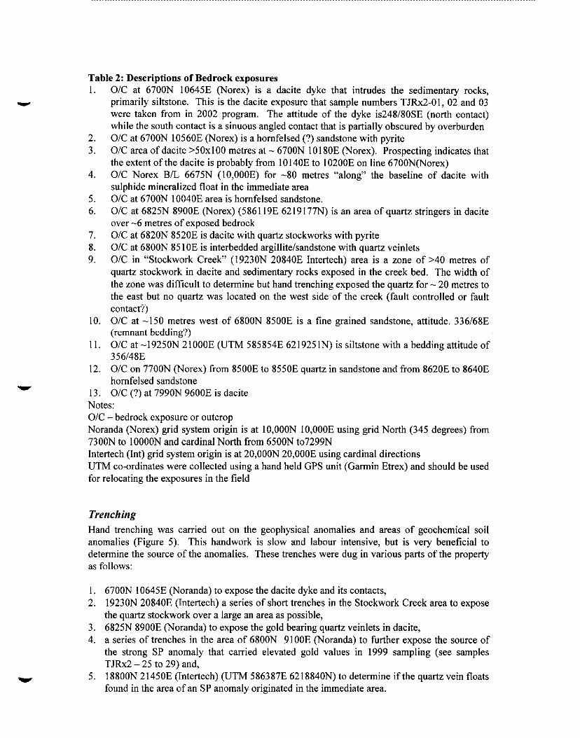
Table 2: Descriptions of Bedrock exposures 1.
2. 3.
4.
5. 6.
I. 8. 9.
10
11,
12
13
O/C at 6700N 10645E (Norex) is a dacite dyke that intrudes the sedimentary rocks, primarily siltstone. This is the dacite exposure that sample numbers TJRxZ-01, 02 and 03 were taken from in 2002 program. The attitude of the dyke is248/80SE (north contact) while the south contact is a sinuous angled contact that is partially obscured by overburden O/C at 6700N 10560E (Norex) is a hornfelsed (?) sandstone with pyrite O/C area of dacite >SOxlOO metres at - 6700N 10180E (Norex). Prospecting indicates that the extent of the dacite is probably from 10140E to 10200E on line 6700N(Norex) O/C Norex B/L 6675N (10,OOOE) for -80 metres “along” the baseline of dacite with sulphide mineralized float in the immediate area O/C at 6700N 10’040E area is hornfelsed sandstone. O/C at 6825N 8900E (Norex) (586119E 6219177N) is an area of quartz stringers in dacite over -6 metres of exposed bedrock O/C at 6820N 8520E is dacite with quartz stockworks with pyrite O/C at 6800N 85 10E is interbedded argillite/sandstone with quartz veinlets O/C in “Stockwrk Creek” (19230N 20840E Intertech) area is a zone of 240 metres of quartz stockwork in dacite and sedimentary rocks exposed in the creek bed. The width of the zone was dificult to determine but hand trenching exposed the quartz for - 20 metres to the east but no quartz was located on the west side of the creek (fault controlled or fault contact?) O/C at -150 metres west of 6800N 8500E is a fine grained sandstone, attitude. 336/68E (remnant bedding?) O/C at -19250N 21000E (UTM 585854E 6219251N) is siltstone with a bedding attitude of 356/48E O/C on 7700N (Norex) from 8500E to 8550E quartz in sandstone and from 8620E to 8640E homfelsed sandstone O/C (?) at 7990N 9600E is dacite
Notes: O/C-bedrock exposure or outcrop Noranda (Norex) grid system origin is at 10,OOON 10,OOOE using grid North (345 degrees) from 7300N to 1OOOON and cardinal North from 6500N to7299N Intertech (Int) grid system origin is at 20,OOON 20,OOOE using cardinal directions UTM co-ordinates were collected using a hand held GPS unit (Gamin Etrex) and should be used for relocating the expo’sures in the field
Trenching Hand trenching was carried out on the geophysical anomalies and areas of geochemical soil anomalies (Figure 5). This handwork is slow and labour intensive, but is very beneficial to determine the source of the anomalies. These trenches were dug in various parts of the property as follows:
1. 6700N 10645E (Noranda) to expose the dacite dyke and its contacts, 2. 1923ON 20840E (Intertech) a series of short trenches in the Stockwork Creek area to expose
the quartz stockwork over a large an area as possible, 3. 6825N 8900E (Noranda) to expose the gold bearing quartz veinlets in dacite, 4. a series of trenches in the area of 6800N 9100E (Notanda) to further expose the source of
the strong SP anomaly that carried elevated gold values in 1999 sampling (see samples TJRx2 - 25 to 29) and,
5. 188OON 21450E (Intertech) (UTM 586387E 621884ON) to determine ifthe quartz vein floats found in the area of an SP anomaly originated in the immediate area.
Geological, Geochemical & Prospecting Report an the Tommy Jack Proprrly - 12-


Descriptions of each trench are provided below.
Detail Map # 1 (Figure 6) Location - 6700N 10645E (Noranda) on the West side of Unnamed Creek approximately 15 metres upslope of the creek. Samples - TJRx2-01, 02, 03. Purpose - to attempt to expose the source of the gold enriched high grade zinc (>7%) located in
the talus immediately below this outcrop.
This trench cleaned talus and overburden from part of the contact areas of the dacite dyke with the adjoining siltstone. The hanging wall dacite/siltstone contact was exposed as well as footwall contact on the south side. The north contact - 248”/80SE - is near vertical and appears to have a slight downward movement on the north side (siltstone). The footwall contact is sinuous and
appears to dip northwest into the hill where the overburden defeats any efforts to measure a definite attitude of the contact.
Detail Map # 2 (Figure 7) Location - 6800N 91 O’OE (Noranda). Samples - TJRx2-25 to 29,33. Purpose -to further ex.pose the gold bearing quartz vein in graphitic siltstone that was discovered in 1999 in order to determine the attitude of the vein and to expose the hanging wall and footwall host rocks.
There was a series of five trenches dug in the area in order to determine the attitude of the vein and to expose the bedrock that hosts the mineralization. The quartz vein varies in thickness; 0.35 metres in the centre trench, 0.20metres in the north trench and to a quartz stockwork in the south trench. Attitudes of the quartz veins are noted on the detail map drawing #2.
Detail Map # 3 Figure 8) Location - 6825N 8900E (Notanda). Samples - TJRx2-22 to 24. Purpose -to further expose a series of quartz veinlets in dacite that were located in 2001.
This trench is 6.5 metn:s with an average width of > 1 .O metre and exposed an area of dacite with series of quartz veins with different orientations.
Detail Map # 4 (Figure 9) Location - 19200N 208:50E (Intertech). Samples - TJRx2-8 to Z! 1. Purpose-to expose a new showing of quartz stockwork in the bedrock.
There was a series of tlrenches and pits that dug to expose and permit sampling of the new quartz stockwork area over as, large an area as possible. The showing area was located during detailed prospecting, and locatezd down-ice direction of the previous soil anomalies. An area of >60 x 20 metres of quartz stoc:kwork and veining was uncovered before the overburden became too extensive to remove by hand. All the quartz was located either in the creek bed or to the east of the creek with no quartz located in the bedrock exposed immediately above (west) of the creek bed, thus indicating either fault control of the quartz or a later fault displacement.
Geological, Geochrmical & Prospecting Report on the Tommy Jack Property _ 14-

Detail Map # 5 (Figure 7) Location - 188OON 21450E (Intertech). Samples - TJRx2-30 to 32. Purpose-to expose the bedrock in an area of quartz vein floats and an SP anomaly.
The trench exposed sandstone bedrock but no quartz veins. The bedrock was a dip slope exposure and did not have any surface to take a reliable attitude measurement.
tz stwk with 10 to 20% carb
rite and shvk of black
x with 2-3%diss
Geological, Geachemical & Prospecting Report on the Tommy Jack Property - 15-

1 SAMPLE 1 DESCRIPTION 1 Type 1 Width 1 Au Ag Pb Zn As
footwall, tine qtz
Graphitic slst hanging wall, no
o/c = outcrop (exposure), sdst = sandstone, slst = siltstone (includes mudstone, claystone and very fine sdst), qtz == quartz, shvk = stockwork, cab. = carbonate usually ankerite, rep. = representative, X = across Analytical values: Au in ppb, Ag, Pb, Zn and As are in ppm. Note: Mass spectrometry results are rounded to the closest ppm or ppb * - fire assays have been converted from grams/tonne to ppb
Geological, Grochemical & F’rospecting Report on the Tommy Jack Property - 16-

.
.
Legend TJRx2 Sample Series
Attitude of betlding
Contact with dip angle
I---\ t,- L-1 - Exposed hrdrwk
SDST - Sandstone SLST - Siltstone O/II-Overburden Rock Samples
TJRx2-01,02,03
uartz vein wIith dip
/ - Foliation with dip angk 40
\ ‘1
/ /
\ / ,’
\-- 90
Tommy Jack Property Trenching Detail Map #l
Figure #6

-I 0 5
Legend TJRx2 Sample Series
w -Sample site and number
& : Attitude of bedding
O*P& - Contact with diip angle
-/- -Contu2t
/---, ;,- _-’ - Exposed hedrwk
s=i$ -Q uartz vein wi!th dip
/ - Foliation with dip angle 40
SDST- Sandstone SLST - Siltstone O/D-Overburden
Rock Samples TJRx2-25 to 29,33
Tommy Jack Property Trenching Detail Map # 2
Figure #7
Marass

Detail Map #3
Detail Map #5 Location 18800N 214503 (Inter-tech)
UTM 5863873 6218840N
Legend TJRx2 Sample Series
1
??-+ - Sample site and number
& -Attitude of bedding
(*do - Contact with dip angle
-./- -Contact
/.-, ;,- --’ - Exposed bedrock
/ 48
- Quartz vein wittl dip
/ 40
- Foliation with dip angle
SDST- Sandstone SLST - Siltstone o/B-Overburden
Rock Samples TJRx2-30,31,32
(30 and 31 are floats) Tommy Jack Property
Trench Detail Map#3 and Map #5 Figure #8
Rock Samples TJRx2-22,23,24

.
.
Contact with dip angle
Rock Samples TJRxZ-8 to 21
Exposed bedrock
uartz vein with dip
/ - Foliation with dip angle
SDST- Sandstone SLST - Siltstone O/B - Overburden
Tommy Jack Property Trenching Detail Map #4
Figure #9

CONCLUSIONS AND RECOMMENDATIONS
The prospecting, mapping, trenching and sampling program carried out on the Tommy Jack property by Gold City Industries Ltd. in 2002 was successful in locating new outcrops and exposed by hand trenching low level precious and base metal values from quarts veins. The detailed prospecting traverses and geological mapping located new exposures, both mineralized and barren, in areas that were thought to be completely covered by overburden. A new quartz stockwork zone (19230N 20840E Intertech) was exposed. Although it did not carry significant gold values, the occurrence proved the potential of significant quartz development on the property which could carry precious metals elsewhere. Prospecting in the north and north-east areas of the property resulted in additional discoveries of mineralized float. Sedimentary beds in this area were found to dip to the east. The easterly dip of the sediments requires a re-evaluation of the Noranda drilling in the area. Since the majority of the Noranda holes were drilled to the east, holes may have poorly tested targets. The hand trenching carried out during the 2002 program over soil anomalies proved useful in exposing bedrock with some quartz veining.
The relatively high values of mercury, arsenic and silver with sporadic gold values hosted in highly altered felsic intrusive and sedimentary rocks with varying degrees of silicification and quartz veining indicate: the upper portion of an epithermal system.
Although the source oaf the high grade precious metal float blocks was not found during the 2002 program, the results of the work conducted during the 2002 season are encouraging. The program proved that detail prospecting and geological mapping will locate additional areas of mineralization.
Recommendations generated from the short 2002 program reaffirm those proposed in 1999.
Self Potential ISurvey
The SP survey should be expanded in order to more fully understand the structural components of the property as indicated by the graphite rich structures and to locate precise targets for further trenching. A few lines should be run over the best Noranda drill results to determine if there is an SP signature. This would, of course, depend on permission from the owner of the “Warren” ground.
V.L.F Survey An expansion of the area covered by the previous VLF survey is warranted in order to delineate any extensions of the present anomalies and to locate any further anomalies that might be associated with precious metal mineralization.
Geochemistry The expansion of a soil geochemistry survey to cover areas of interest is warranted including a more detailed inlill survey in the main target zone and more detailed surveys in any new anomalies that are developed.
Geological Mapping and Detail Prospecting The work carried out this year has proven that meticulous work carried out in the drainages and steeper areas of the property will discover more bedrock exposures than originally was thought to
Geological, Ceochemicsl & P:rosprcting Report on the Tommy Jack Property -21-

be the case. Bedrock exposures will be located by very careful prospecting and then mapped by a geologist or other qualified personnel.
Trenching More hand trenching should be carried out on the geophysical anomalies and other areas of interest. This handwork is slow and labour intensive but is very beneficial to the source of anomalies. Mechanize’d trenching should be considered in appropriate terrain.
Previous data The previous geochemical data generated by the soil surveys should be reassessed in view of the determination that the ice movement was from the north, thus transporting the soil anomalies and floats uphill.
Gealogienl, Geoehemieal & PWqmting Report an the Tommy Jack Properly -22-

REFERENCES
Allen, D.G. (1988). Summary report on the Tommy Jack Creek Property Private report for Intertech Minerals Corp.
Carter, NC. (1981). Porphyry Copper and Molybdenum Deposits, West-Central British Columbia. B.C. Minister of Mines, Energy and Petroleum Resources Bulletin 64.
Dale, A. and McArthur, R. (1985)“Geochemical Report” on the Tommy Jack Creek Property B.C. Mines Energy and Petroleum Resources Assessment Report 1463 1.
Eisbacher, G. H. (197:7). Mesozoic-Tertiary Basin Models for the Canadian Cordillera and Their Geological Constants. Can. Jour. of Earth Sciences , Vol. 14, pp. 2414 - 2421.
Kindle, E.D. (1954). Mineral Resources, Hazelton and Smithers Areas, Cassiar and Coast Districts, British Columbia. Geological Survey, Memoir 223 (revised edition).
Myers, D.E. (1988). 1987 Year End Report on the Tommy Jack Property, Noranda Exploration.
Myers, D.E. (1986) Report on Drilling, Geophysics and Geochemistry on the Tommy Jack Property. B.C. Min. Mines Energy and Petroleum Resources, Assessment Report 155 15.
Myers, D.E. (1985) Geology and Geochemistry of the Tommy Jack Property. B.C. Min. Energy, Mines and Petroleum Resources, Assessment Report 13778.
Raven, A.R. (1995) G~eological, Prospecting and Geochemical Report on the TJ 9and 10 Mineral Claims Assessment Report #24589.
Raven, A.R. (1999) Geological, Geophysical and Prospecting Report on the Tommy Jack Property consisting of the TJ 1 to 4, TJ 8 to 13 and TJ 17, 18 to 22 Mineral Claims Assessment Report #26197.
Tipper H.W. and RichLards, T.A. (1976). Jurassic Stratigraphy and the History of North-Central British Columbia. Geological Survey of Canada Bulletin 270.
-23 -

APPENDIX I
Analytical Results

PHONE(604)253-3158
No Cu Pb co M" Fe As " A" Th r pm PP wm PW m wm Ppm % m PP wb w PPm PW Pm Pw ppm
1 .lQ ,001 4 2.4 c.01 2 3 1.10 ,055 9 4.7 .Q7 79
15 1.89 ,062 5 5.0 .28 70 2 .89 ,064 12 4.0 .Q5 88
22 .I6 ,061 4 7.7 .72 26
.5 1.3 .3 4 c.1 .8 .l 10 .Q5 c.5 c.1 2.2 c.1 2 Cl Cl c.1
.7 11.3 76.1 170 .2 13.2 3.7 712 1.89 38.6 .3 3.4 2.2 35 2.1 .6 .1
.3 15.5 203.6 14694 3.2 12.8 7.3 1109 3.24 62.2 .3 4.9 1.6 35 163.2 13.8 .2 7.3 2.5 .1 .8 22.3 116.9
.8 80.8 111.4
1.3 1424.0 517.1 1.3 269.4 46.5 1.7 48.9 420.6 2.3 9.3 6.0
818 1.6 7.7 3.9 999 1.68 155.6 .3 5.2 2.7 21 49 2.7 13.7 11.4 583 3.99 316.8 <.I 1595.9 .6 13 .3 2.1 1.4
/
%X2-l JRX2-2 JRX2-3 JRXZ-4
59 18.6 41.7 11.4 321 5.42 404.9 <.I 2421.3 .5 8 50 4.2 10.7 5.8 1040 3.64 144.9 c.1 734.4 .4 II
711 4.2 6.8 4.4 677 2.15 206.1 .l 769.4 .8 20 39 .i 8.8 7.0 iii0 2.76 28.6 <.i i4.0 .i i5G
.2 7.2 4.7 1361 2.92 35.1 <.I 10.0 .1 165 30
.8 11.0 .B
.6 1.3 .l 7.9 4.5 .9
.3 .5 .i
.* .6 .1
13 .ll .045 2 7.8 .39 23 19 .12 ,037 3 11.6 .6Q 27
7 .57 ,044 5 11.0 .lQ 51<.001 - ^ _^ ^^. I L.00 .“Jl i ii.0 .3i ii
12 3.33 ,045 1 13.5 .4Q l8cQQl
.2 .5 .1 10 2.73 ,033
2.5 5.8 4.0 JRK-lo 2.8 6.7 3.3 JRX2-ll 2.3 7.9 2.7 JRXZ-12 2.1 9.3 2.1 xX2-13 2.9 8.4 2.1 JRXZ-14 1.8 10.1 2.3
29 24 29
::
.i 7.9 6.5 ,116 2.65 15.1 c.1 8.0 .2 154
4.2 4.3 2.7 1.9 44.5 2.8 2.3 8.1 69.4 1.4 8.8 62.1 2.2 6.8 3.3
.2 7.5 3.9 1290 2.90 49.3 <.I 15.0 .l 108
.2 7.6 4.5 933 2.30 18.5 <.I 8.4 .1 48
.l 5.6 3.9 971 2.56 11.7 cl 6.5 .1 104
.1 7.2 5.5 967 2.48 14.2 c.1 7.2 .2 86
25 .l 5.5 5.0 859 2.06 9.8 c.1 6.4 .3 142 58 .4 8.5 7.9 1384 3.68 55.4 <.I 13.2 .2 63 63 .3 9.5 10.5 901 3.79 35.7 c.1 17.4 .3 30 59 .3 11.3 13.3 992 5.01 36.8 <.I 20.0 .4 30 29 .l 10.9 8.9 798 2.74 14.8 c.1 12.4 .2 34
.8 8.9 3.0 22 1.0 9.9 3.4 24 6.0 16.3 8.2 33 1.3 24.1 11.7 72
.2 8.2 8.9 2620 5.29 33.2 cl 22.4 .3 235
.3 9.0 9.6 2705 1.48 36.2 <.I 24.7 .3 253
.1 7.1 10.2 928 2.14 11.7 c.1 8.6 .3 13
.2 22.1 27.0 2855 4.06 174.2 .2 18.3 1.4 26 1.4 7.6 8.7 939 4.47 2345.6 ~1 1942.7 1.0 14
.7 17.8 26.8 2371 4.09 3841.7 .I 946.1 1.1 22
.6 4.6 2.0 172 1.99 242.0 c.1 44.0 <.I 6 1.9 13.0 16.0 407 4.88 306.9 .4 10.2 1.2 35
.7 8.6 17.7 740 6.81 218.2 .4 136.5 .8 291
.4 3.7 1.4 II 1.51 157.3 c.1 3.1 <.I 5
.7 3.5 1.3 75 .81 86.4 ~1 113.5 <.I 6
1 11.0 .28 23 1 14.9 .I3 16 1 14.0 .15 1kQQ1 1 13.4 .23 18 1 11.0 ~24 lkOQ1
.2 .8 .I
.2 .7 Cl
.2 .4 <.I
.3 .4 c.1
.l .4 .l
.3 .9 .I
.5 1.0 .3
13 2.08 ,040 13 .99 ,031 15 1.76 ,063 16 1.65 ,044
13 2.43 ,115 1 12.9 .51 19 23 1.08 ,030 2 12.8 .11 24 16 .lQ ,054 4 12.6 .Q2 24<,001 20 .14 ,065 4 10.6 .Q3 33 11 .9Q ,035 1 12.6 .Q6 23
%X2-15 JRX2-16 JRXZ-17 JRX2~18 JRXZ-19
.2 1.0 .4
.3 .4 .1
1.9 48.1 130.0 234
JRXZ-24 1.3 31.8 78.7 236 xX2-25 2.8 21.4 16.1 14 JR%26 3.4 109.4 35.9 157 JRX2~27 5.9 136.2 94.5 131 JRXZ-28 1.6 7.9 11.9 6
1.7 32.8 168.2 30 2.9 3.8 119.2 2 4.4 2.7 .3 41 .47 41.8 <.l 177.1 <.I 3 1.6 9.4 26.8 9 .6 3.3 .7 145 1.34 225.5 c.1 105.0 <.I 4 1.4 478.3 5.9 23 2.4 18.5 20.4 1175 4.67 65.6 .l 122.5 LO 32 2.9 56.8 22.6 49 1.0 5.2 2.6 264 4.00 509.5 .2 91.5 .I 23
27 5.48 ,034 2 7.7 .54 39 28 5.69 ,036 2 7.8 ~56 40
9 .lQ ,046 3 14.3 .Q2 15 17 .Q7 ,055 10 8.0 .Q3 72 11 .Ql ,041 5 8.3 .Ql 63
11 .Q5 .Q61 2 .Ql .Qll
23 .03 ,041 33 .13 ,154
i c.01 ,003
8 5.9 .Q3 63 ~1 18.6 c.01 14
9 7.6 ,119 78 9 8.4 .Q2 232c.001
cl 19.6 c.01 1kQO1
JRXZ-2Q E TJRXZ-20 JRXZ-21 JRXZ-22 JRX2~23
.2 1.2 .2
.2 1.3 .3
.2 .4 c.1 1.0 1.1 .3 1.2 3.7 2.4
2.6 9.2 1.3 .3 .* 1.3
1.2 1.9 1.2 2.4 3.3 1.7
.1 .6 1.1
.I 1.0 1.2 1 .Ql ,001 2 18.1 c.01 10 2 .Ql .QQ3 cl 17.9 c.01 11 2 .Ql ,007 4 16.0 c.01 13<.001
JRX2-29 JRXZ-30 JRXZ-31 JRX2~32 JRX2~33
cl .6 3.1 cl .8 2.2
.3 1.3 .E .5 1.6 2.2
40 .26 ,103 8 6.9 .Q9 49 4 .I7 ,020 1 14.1 .Q1 18
TANQARQ 053 8.8 126.7 33.5 154 .3 33.8 12.0 783 3.24 29.6 6.6 19.3 3.8 29 5.7 5.2 5.6 81 .55 ,082 18 170.8 .57 137
GROUP 1DA - 10.0 GM SAMPLE LEACHED V,TH 60 ML 2-2-2 HCL-HN03-HZ0 AT 95 DEG. C FOR ONE HWR, DILUTED TO 200 UPPER Ll"lTS - AG, A", HO, V = 100 PPEI; NO, CO, CO, SB, 81, TH, " & B = 2,000 PPH; C", PB, ZN, NI, MN, AS, . SAMPLE TYPE: ROCK R150 60C samples beginninq 'RE' are Reruns and 'ImE' are Reiect Reruns.
t
,&AT~CE~~;~).3 ?I DAT;,,,,, c SIGNED BY...: ToIE,
ALL r ULtS are considered the conf dent1 L ~ro~erfy liabilities for a the analysis
A '
ANALYTICAL LABORATORIES LTD. VANCOUVER BC V6A lR6 PHONE(604)253-3158 ,(ISO 9002 Accredite$~:Co.)
852 E. HASTINGS (
ASSAY q2RTIFICnTE
Gold City Industries,~Ltd,:, File # A202391R2 550 - 580 Hornby Sf.,~ Ya"cO""er BC "6C 386
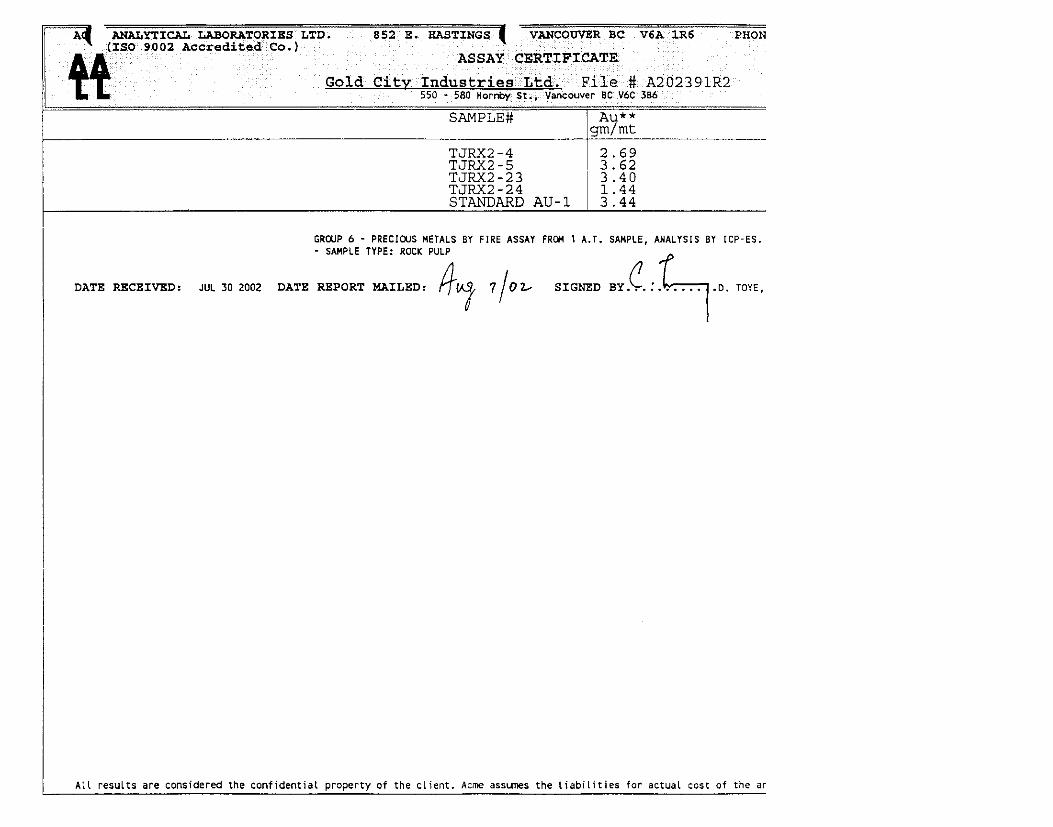
SAMPLE# AU** nm /m+
DATE RECEIVED: JUL 30 2002 DATE REPORT MAILRD:

APPENDIX II
Statement of Costs

STATEMENT OF COSTS
TOMMY JACK PROPERTY 2002 EXPLORATION PROGRAM
FIELD PERSONNEL A. Raven - Field Manager (High Range Exploration Ltd.)
G. Lovang - Field Assistant
M. Moorman - Field Assistant
18 days @ $25O/day July 1 -July 20,2002 16 days @ 6175lday July 2 July 17,2002 16 days @ $25O/day July 2 -July 17,2002
$ 4,500.oo
$ 2,800.OO
$ 4,ooo.oo
CONSULTANTS P. Cowley, P.Geo. Geologist 4 days @ $320/day
July IO-July 13,2002 $ 1.280.00
FOOD AND ACCOMMODATION
VEHICLE RENTALS
$ 833.87
$ 1,331.79
EQUIPMENT AND SUPPLIES Field Supplies Fuel & Lubes
$ 739.35 .s 357.56
EQUIPMENT RENTA:L $ 580.00
AIRCRAFT SUPPORT Helicopter - Mobilizatiomn/Demobilization
Canadian Helicopters Limited, Smithers, BC $ 8.043.36
EXPEDITING SERVICES $ 761.25
TRAVEL P. Cowley - Airfare - Vancouver/Smithers G. Lovang - Mileage - VancouveriSmithers
LABORATORY ANALYSIS
REPORT PREPARATION
$ 516.04 $ 836.76
$ 749.95
$ 1,500.00
TOTAL $28.829.93

APPENDIX III
Statement of Qualifications

PAUL S. COWLEY, PGEO.
I, Paul S. Cowley, P.Geso., of 207-270 West 1”’ Street, North Vancouver, British Columbia hereby certify as follows:
1. I graduated with Honours with a Bachelor of Science degree in Geology, from University of British Columbia, Canada, in 1979.
2. I am a registered Pr’ofessional Geologist of the Northwest Territories, Canada, Registration Number L445, since October 5, 1989.
3. I am a registered Pr’ofessional Geoscientist of the Province of British Columbia, Canada, Registration Number 24350, since June 1999.
4. I have been directly involved in the mining industry for 22 years. I have worked directly in exploration of Epithennal and Mesothermal gold, Volcanogenic Massive Sulfide, porphyry copper, coal, diamonds and industrial minerals projects during this time.
5. In 2002, I was retained by the Gold City Industries Ltd. as a non-independent consultant (currently Vice President of the Company) for the evaluation of the Tommy Jack property. I was on site for sonx the 2002 mapping, trenching and prospecting program described in this report.
6. This Assessment Report is an accurate account of the 2002 exploration season for the properties contained.
Dated at Vancouver, BC. this 16” day of December, 2002.

ALAN RAVEN
I, Alan Raven, of Box :204, Madeira Park, British Columbia, VON 2H0 hereby certify as follows:
1.
2.
3.
4.
5.
6.
I have been directly involved in the mining industry as a prospector since 1969.
Between 1977 and 1998 I have taken a variety of prospectors’ courses and exploration short courses.
My field exploration experience includes geochemical and geophysical surveying, diamond drilling, prospecting, mapping, crew training, and exploration project management in British Columbia and the Western United States (Washington, California, Nevada, Arizona, and Utah).
I hold title to the Tommy Jack mineral property, which is currently under option to Gold City Industries Ltd.
Since 2000 I have been retained through my company, High Range Exploration Ltd., as a field manager for Gold City Industries Ltd. I was on site for the entire 2002 mapping, trenching, and prospecting program described in this report. I was not involved in the handling of samples.
This Assessment Report is an accurate account of the 2002 exploration season for the Tommy Jack property.
Dated at Vancouver, B.C this 16” day of December, 2002.
&LkL Alan Raven