tonbridge and malling borough council level 1 strategic ... · borough council level 1 strategic...
TRANSCRIPT

Tonbridge and Malling Borough Council Level 1 Strategic Flood Risk Assessment Final Report
August 2016

2016s3886 - Tonbridge & Malling Level 1 SFRA (v4 August 2016).docx i
JBA Project Manager Ben Gibson BSc MSc MCIWEM C.WEM JBA Consulting 35 Perrymount Road Haywards Heath West Sussex RH16 3BW
Revision History Revision Ref / Date Issued Amendments Issued to
Draft v1 Template report to indicate proposed structure.
Nigel De Wit, Louise Reid and Ian Bailey (Tonbridge and Malling Borough Council)
Draft v2 / June 2016 Full report updated following Tonbridge and Malling Borough Council review comments
Nigel De Wit, Louise Reid and Ian Bailey (Tonbridge and Malling Borough Council)
Draft v3 / August 2016 Minor adjustments to Executive Summary following review by Tonbridge and Malling Borough Council, and also including updated climate change modelling information
Nigel De Wit, Louise Reid and Ian Bailey (Tonbridge and Malling Borough Council)
Final v4 / August 2016 Minor adjustments following an email received from Tonbridge and Malling Borough council dated 26 August 2016
Nigel De Wit, Louise Reid and Ian Bailey (Tonbridge and Malling Borough Council)
Contract This report describes work commissioned by Tonbridge and Malling Borough Council. The Council's representative for the contract was Nigel De Wit. Georgina Latus, Zoe Carroll and Ben Gibson of JBA Consulting carried out this work.
Prepared by .................................................. Georgina Latus BSc
Technical Assistant
....................................................................... Zoe Carroll BSc MSc
Assistant Analyst
....................................................................... Ben Gibson BSc MSc MCIWEM C.WEM
Chartered Senior Analyst
Reviewed by ................................................. Claire Gardner BSc MSc MCIWEM C.WEM
Chartered Senior Analyst
....................................................................... Alastair Dale BSc PGDip MIAHR
Director

2016s3886 - Tonbridge & Malling Level 1 SFRA (v4 August 2016).docx ii
Purpose This document has been prepared as a Final Report for Tonbridge and Malling Borough Council. JBA Consulting accepts no responsibility or liability for any use that is made of this document other than by the Client for the purposes for which it was originally commissioned and prepared.
JBA Consulting has no liability regarding the use of this report except to Tonbridge and Malling Borough Council.
Copyright © Jeremy Benn Associates Limited 2016.
Carbon Footprint A printed copy of the main text in this document will result in a carbon footprint of 503g if 100% post-consumer recycled paper is used and 640g if primary-source paper is used. These figures assume the report is printed in black and white on A4 paper and in duplex.
JBA is aiming to reduce its per capita carbon emissions.
2016s3886 - Tonbridge & Malling Level 1 SFRA (v4 August 2016).docx iii
Executive Summary Introduction
This Strategic Flood Risk Assessment (SFRA) 2016 document replaces the Level 1 SFRA originally published by Tonbridge and Malling Borough Council in August 2006 and updated in February 2011. The report has been prepared to replace the content that was included in the previous SFRA and to provide appropriate supporting evidence for the emerging Local Plan.
The 2016 SFRA update will be used in decision-making and to inform decisions on the location of future development and the preparation of sustainable policies for the long-term management of flood risk.
SFRA objectives
The Planning Practice Guidance advocates a tiered approach to risk assessment and identifies the following two levels of SFRA:
Level 1: where flooding is not a major issue and where development pressures are low. The assessment should be sufficiently detailed to allow application of the Sequential Test.
Level 2: where land outside Flood Zones 2 and 3 cannot appropriately accommodate all the necessary development (see outputs from the Level 1 SFRA) creating the need to apply the National Planning Policy Framework’s (NPPF) Exception Test. In these circumstances the assessment should consider the detailed nature of the flood characteristics within a Flood Zone and assessment of other sources of flooding.
This document is an updated Level 1 SFRA document. The key objectives of the 2016 SFRA are:
To take into account the latest flood risk policy following key changes to policy and guidance that have occurred since the previous SFRA was published.
To take into account the latest flood risk information and available data since the previous SFRA.
To provide a comprehensive set of maps presenting flood risk from all sources that can be used as part of the evidence base for the Local Plan.
To provide initial flood risk analysis information for sites identified by the Council as part of their Local Plan preparation.
SFRA outputs
To meet the objectives, the following outputs have been prepared:
Appraisal of all potential sources of flooding, including Main River, Ordinary Watercourse, surface water and groundwater.
Updated review of historical flooding incidents.
Mapping of location and extent of functional floodplain.
Reporting on the standard of protection provided by existing flood risk management infrastructure.
An assessment of the potential increase in flood risk due to climate change.
Areas at risk from other sources of flooding, for example surface water or reservoirs.
An assessment of existing flood warning and emergency planning procedures, including an assessment of safe access and egress during an extreme event.
Recommendations of the criteria that should be used to assess future development proposals and the development of a Sequential Test and sequential approach to flood risk.
High level screening of proposed development sites against flood risk information.

2016s3886 - Tonbridge & Malling Level 1 SFRA (v4 August 2016).docx iv
Summary of Level 1 Assessment
The SFRA has considered all sources of flooding within the borough. Fluvial flood risk has been analysed using the results from computer models supplied by the Environment Agency, as well as existing Environment Agency Flood Zone mapping. Surface water flood risk has been assessed using the updated Flood Map for Surface Water published online by the Environment Agency and recorded flood incidents supplied by various sources. A number of other data sources have been drawn upon as an evidence base, including data from Southern Water, National Inundation Reservoir Mapping from the Environment Agency and various geology / groundwater products and datasets from the Environment Agency.
The Level 1 SFRA assessment concluded the following:
Tonbridge and Malling Borough has a history of documented flood events and flood records indicate that the main source of risk is from fluvial sources.
The primary source of fluvial flood risk to the borough is the River Medway, which is of fluvial influence in the south and estuarine/tidal influence in the north. Other sources of fluvial flood risk include, but are not limited to, the River Bourne and Hawden Stream, both of which are also designated Main Rivers.
The most significant flood events reported to have affected the borough occurred in 1953, 1968, 2000 and 2013/14, each of which included notable flooding from the River Medway.
Tonbridge and Malling Borough has also experienced a number of historic surface water / drainage related flood events, which have been attributed to a range of sources. The primary source of surface water flooding was attributed to heavy rainfall overloading highway carriageways and paved areas, drains and gullies, but other sources of flooding were perceived to be from blockages and high water levels impeding free discharge from surface water drains and gullies. The updated Flood Map for Surface Water (uFMfSW) shows a number of surface water flow paths which predominantly follow topographical flow paths along existing watercourses or dry valleys with some isolated ponding located in low lying areas.
Data from the Sewer Incident Report Form data supplied by Southern Water indicates a total of 83 recorded flood incidents in the borough. The more frequently flooded postcodes are TN9 1, TN11 9 and ME20 6. However, it is important to recognise that the information does not present whether flooding incidences were caused by general exceedance of the design sewer system, or by operational issues such as blockages.
Only two groundwater flood events have been recorded across the borough. The causes of these are thought to be related to high water tables and burst underground pipes rather than flooding from hard rock aquifers of superficial deposits. However, the Areas Susceptible to Groundwater Flooding (AStGWF) mapping suggests that susceptibility to groundwater flooding is greatest in the north of the borough, specifically in the areas of Birling, New Hythe, Leybourne and Snodland. This groundwater flood potential is consistent with the location of more permeable strata to the north of the borough.
National Inundation Reservoir mapping indicates that there are three reservoirs that could affect the borough in the event of a breach. This includes Leigh Flood Storage Area, located at the south west extent of the borough, a breach of which could have notable implications for Tonbridge and the wider borough area.
A high-level review of formal flood defences was carried out using existing information to provide an indication of their condition and standard of protection. Details of the flood defence locations and condition were provided by the Environment Agency for the purpose of preparing this assessment, in addition to explanations of some of these defences.
A Sequential risk based approach has been adopted to the preparation of the Level 1 SFRA which has involved an interactive process for the selection of appropriate potential development sites for the Local Plan. The relatively extensive areas of land available for potential housing development in Zones 1 and 2 has made it possible to align the selection of housing land when performing the Sequential Test so all potential new housing sites can be located on land outside of the high risk Flood Zone. Where potential housing sites are shown to comprise some land in a high risk Flood Zone, proposed development will only be allowed to take place on land zoned as medium or low risk, and if appropriate any supplementary housing will be located on land immediately adjacent to the housing site on land in a medium or low risk Zone. Since it is not proposed to place any

2016s3886 - Tonbridge & Malling Level 1 SFRA (v4 August 2016).docx v
proposed housing development on land in a high flood risk Zone there is no trigger to apply the Exception Test and, therefore, no requirement to prepare a Level 2 SFRA, as there is not a need to demonstrate proposed development is safe during a flood for land allocations in the Plan.
This SFRA provides details of the FRA requirements and guidance for developers. These recommendations include those of the NPPF, Environment Agency standing advice, as well as reference to regional and local policy. Site-specific FRAs should include assessment of mitigation measures required to safely manage flood risk along with the promotion of Sustainable Drainage Systems (SuDS) to create a conceptual drainage strategy and safe access/egress at the development in the event of a flood.
Surface water flooding and the role of the Lead Local Flood Authority (LLFA) and the Local Planning Authority (LPA) in surface water management has been defined with guidance provided for the design and implementation of SuDS as part of the initial planning stage of all types of residential, commercial and industrial developments. The SFRA provides details of the types of SuDS available and when they should be used, and outlines the recommendations included in the relevant national, regional and local guidance documents.
Strategic flood risk solutions should be considered and understood when considering development within the borough. Developers should work with stakeholders to identify issues and provide suitable solutions.
Emergency planning considerations have been included and the flood warning service coverage assessed; currently there are three Flood Alert Areas and seven Flood Warning Areas covering Tonbridge and Malling Borough. Requirements outlined by the NPPF for safe access and egress have also been set out.
Recommendations
Assessing Flood Risk and Developments
The NPPF supports a risk-based and sequential approach to development and flood risk in England, so that development is located in the lowest flood risk areas where possible; it is recommended that this approach is adopted for all future developments within the borough.
A site-specific FRA is required for all developments which are located in the Environment Agency’s Flood Zones 2 and 3, or developments greater than 1 ha in size in Flood Zone 1. They are also required for developments less than 1 ha in Flood Zone 1 where there is a change in use to a more vulnerable development where they could be affected by sources of flooding other than rivers and the sea (e.g. surface water drains, reservoirs). All developments located in areas of Flood Zone 1 highlighted as having critical drainage problems must also be accompanied by an FRA. The FRA should be proportionate to the degree of flood risk, as well as the scale, nature and location of the development.
It is recommended that the impact of climate change to a proposed site is considered in FRAs and that the percentage increases which relate to the proposed lifetime of the development and the vulnerability classification of the development is identified and taken into account. The Environment Agency and LLFA should be consulted to confirm a suitable approach to climate change in light of the latest guidance.
Opportunities to reduce flood risk to wider communities could be sought through the regeneration of brownfield sites, through reductions in the amount of surface water runoff generated on a site.
The Local Planning Authority (LPA), Environment Agency and LLFA should be consulted to confirm the level of assessment required and to provide any information on any known local issues.
When assessing sites not identified in the Local Plan (windfall sites), developers should use evidence provided in this SFRA to apply the Sequential Test as well as provide evidence to show that they have adequately considered other reasonably available sites.
As noted above a Sequential risk based approach has been adopted to the preparation of the Level 1 SFRA. The relatively extensive areas of land available for potential housing development in Zones 1 and 2 has made it possible to align the selection of housing land when performing the Sequential Test so all potential new housing sites can be located on land outside of the high risk Flood Zone. Where potential housing sites are shown to
2016s3886 - Tonbridge & Malling Level 1 SFRA (v4 August 2016).docx vi
comprise some land in a high risk Flood Zone, proposed development will only be allowed to take place on land zoned as medium or low risk, and if appropriate any supplementary housing will be located on land immediately adjacent to the housing site on land in a medium or low risk Zone.
Future Developments
Development must seek opportunities to reduce overall levels of flood risk at the site, for example by:
Reducing volume and rate of surface water runoff based on Local Plan policy and LLFA Guidance
Locating development to areas with lower flood risk Creating space for flooding. Integrating green infrastructure into mitigation measures for surface water runoff from
potential development and consider using Flood Zones 2 and 3 as public open space. The LPA should consult the NPPF and Environment Agency’s ‘Flood Risk Standing Advice (FRSA) for Local Planning Authorities’, published in March 2014, when reviewing planning applications for proposed developments at risk of flooding.
At the planning application stage, developers may need to undertake more detailed hydrological and hydraulic assessments of the watercourses to verify flood extent (including latest climate change allowances) inform development zoning within the site and prove, if required, whether the Exception Test can be passed.
Promotion of SuDS
Planners should be aware of the conditions set by the LLFA for surface water management and ensure development proposals and applications are compliant with the Council’s policy. These policies should also be incorporated into the Local Plan.
A detailed site-specific assessment of SuDS would be needed to incorporate SuDS successfully into the development proposals. New or re-development should adopt source control SuDS techniques to reduce the risk of frequent low impact flooding due to post-development runoff.
For proposed developments, it is imperative that a site-specific infiltration test is conducted early on as part of the design of the development, to confirm whether the water table is low enough to allow for SuDS techniques that are designed to encourage infiltration.
Where sites lie within or close to Groundwater Source Protection Zones or aquifers, there may be a requirement for a form of pre-treatment prior to infiltration. Further guidance can be found in the CIRIA SuDS manual on the level of water quality treatment required for drainage via infiltration. Further restrictions may still be applicable and guidance should be sought from the LLFA.
Developers need to ensure that new development does not increase the surface water runoff rate from the site and should therefore contact the LLFA and other key stakeholders at an early stage to ensure surface water management is undertaken and that SuDS are promoted and implemented, designed to overcome site-specific constraints.
The LPA will need to consider drainage schemes for major applications, but it is advised developers utilise the LLFA’s Polices and Guidance to develop their drainage scheme for minor applications.
Infrastructure and Access
Safe access and egress will need to be demonstrated at development sites. Consideration of alternative access and egress routes should be made in the event that primary routes are inundated with flood water. Resilience measures will be required if buildings are situated in the flood risk area, and opportunities to enhance green infrastructure and reduce flood risk by making space for water should be sought.

2016s3886 - Tonbridge & Malling Level 1 SFRA (v4 August 2016).docx vii
Green Infrastructure and WFD
Opportunities to enhance green infrastructure and reduce flood risk by making space for water should be sought. In addition, opportunities where it may be possible to improve the WFD status of watercourses, for example by opening up culverts, weir removal, and river restoration, should be considered. Green infrastructure should be considered within the mitigation measures for surface water runoff from development.
Use of SFRA data and future updates
It is important to recognise that the SFRA has been developed using the best available information at the time of preparation.
The SFRA should be periodically updated when new information on flood risk, flood warning or new planning guidance or legislation becomes available. New information on flood risk may be provided by authorities including Tonbridge and Malling Borough Council, Kent County Council (in its role as LLFA), the Highways Authority, Southern Water and the Environment Agency. It is recommended that the SFRA is reviewed internally on an annual basis, allowing a cycle of review, followed by checking with the above bodies for any new information to allow a periodic update.

Contents
2016s3886 - Tonbridge & Malling Level 1 SFRA (v4 August 2016).docx
Executive Summary ............................................................................................................ iii
1 Introduction ............................................................................................................ 1
1.1 Purpose of the Strategic Flood Risk Assessment .............................................................. 1 1.2 SFRA objectives ................................................................................................................. 2 1.3 SFRA outputs ..................................................................................................................... 2 1.4 Approach ............................................................................................................................ 2 1.5 Consultation ....................................................................................................................... 3 1.6 SFRA user guide ................................................................................................................ 4
2 The Planning Framework and Flood Risk Policy ................................................... 6
2.1 Introduction ........................................................................................................................ 6 2.2 Flood Risk Regulations (2009) and Flood and Water Management Act (2010) ................. 6 2.3 National Planning Policy Framework .................................................................................. 9 2.4 Surface Water Management Plans .................................................................................... 10 2.5 Catchment Flood Management Plans ................................................................................ 11 2.6 River Basin Management Plans ......................................................................................... 12 2.7 Shoreline Management Plan .............................................................................................. 12 2.8 Association of British Insurers Guidance on Insurance and Planning in Flood Risk Areas
for Local Planning Authorities in England ........................................................................... 13 2.9 Implications for Tonbridge and Malling ............................................................................... 13
3 How flood risk is assessed .................................................................................... 16
3.1 Definitions .......................................................................................................................... 16 3.2 Using SFRA risk information .............................................................................................. 17 3.3 Possible responses to flooding........................................................................................... 20
4 The sequential, risk based approach ..................................................................... 22
4.1 The Sequential, risk-based approach ................................................................................. 22 4.2 Applying the Sequential Test and Exception Test in the preparation of a Local Plan......... 22 4.3 Applying the Sequential Test and Exception Test to individual planning applications ........ 24 4.4 Summary of SFRA mapping for all sources of flood risk .................................................... 25 4.5 Other relevant flood risk information .................................................................................. 26
5 Understanding flood risk in Tonbridge and Malling Borough ................................. 27
5.1 Historical flooding ............................................................................................................... 27 5.2 Topography, geology, soils and hydrology ......................................................................... 29 5.3 Fluvial flood risk ................................................................................................................. 32 5.4 Tidal flood risk .................................................................................................................... 35 5.5 Surface water flooding ....................................................................................................... 35 5.6 Groundwater flooding ......................................................................................................... 36 5.7 Flooding from artificial sources........................................................................................... 37 5.8 The impact of climate change ............................................................................................ 39
6 Flood defences ...................................................................................................... 42
6.1 Defence standard of protection and residual risk ............................................................... 42 6.2 Defence condition .............................................................................................................. 42 6.3 Defences in Tonbridge and Malling Borough ..................................................................... 43 6.4 Other defence works .......................................................................................................... 48 6.5 Potential flood management schemes ............................................................................... 48
7 FRA requirements and guidance for developers ................................................... 49
7.1 Over-arching principles ...................................................................................................... 49 7.2 Requirements for flood risk assessments .......................................................................... 49 7.3 Mitigation measures ........................................................................................................... 50 7.4 Reducing flood risk ............................................................................................................. 50 7.5 Making Space for water ..................................................................................................... 53 7.6 Reducing flood risk from other sources .............................................................................. 54
8 Surface water management and SuDS ................................................................. 56

Contents
2016s3886 - Tonbridge & Malling Level 1 SFRA (v4 August 2016).docx
8.1 What is meant by Surface Water Flooding? ....................................................................... 56 8.2 Role of the LLFA and Local Planning Authority in surface water management .................. 56 8.3 Level 1 Assessment of Surface Water Flood Risk ............................................................. 57 8.4 Sustainable Drainage Systems (SuDS) ............................................................................. 58 8.5 Types of SuDS Systems .................................................................................................... 59 8.6 Kent SuDS Guidance ......................................................................................................... 61 8.7 Groundwater Vulnerability Zones ....................................................................................... 63 8.8 Groundwater Source Protection Zones (GSPZ) ................................................................. 64 8.9 Nitrate Vulnerable Zones ................................................................................................... 65
9 Flood warning and emergency planning ................................................................ 67
9.1 Flood emergencies ............................................................................................................. 67 9.2 Existing Flood Warning Systems........................................................................................ 67 9.3 Lead times and onset of flooding ....................................................................................... 69 9.4 Managing flood emergencies ............................................................................................. 69 9.5 Emergency planning and development .............................................................................. 71
10 Strategic flood risk solutions .................................................................................. 75
10.1 Introduction ........................................................................................................................ 75 10.2 Flood defences................................................................................................................... 75 10.3 Flood storage schemes ...................................................................................................... 76 10.4 Floodplain restoration ......................................................................................................... 77 10.5 Engaging with key stakeholders ......................................................................................... 77
11 Development control recommendations ................................................................ 78
11.1 Overview ............................................................................................................................ 78 11.2 Development control policy ................................................................................................ 78
12 Level 1 summary assessment of potential development locations ....................... 81
12.1 Introduction ........................................................................................................................ 81 12.2 Sequential Testing ............................................................................................................. 81
13 Summary ............................................................................................................... 94
13.1 Level 1 SFRA Assessment ................................................................................................ 94 13.2 Recommendations ............................................................................................................. 96 13.3 Use of SFRA data and future updates ............................................................................... 97
Appendices ......................................................................................................................... I
A Index grid squares for Appendix mapping ............................................................. II
B Watercourses in Tonbridge and Malling Borough ................................................. III
C Flood Zone mapping .............................................................................................. IV
D Climate change mapping ....................................................................................... V
E Surface water mapping .......................................................................................... VI
F Groundwater mapping ........................................................................................... VII
G Flood warning coverage ........................................................................................ VIII
2016s3886 - Tonbridge & Malling Level 1 SFRA (v4 August 2016).docx
List of Figures Figure 1-1: Flood Risk Management Hierarchy .................................................................. 3
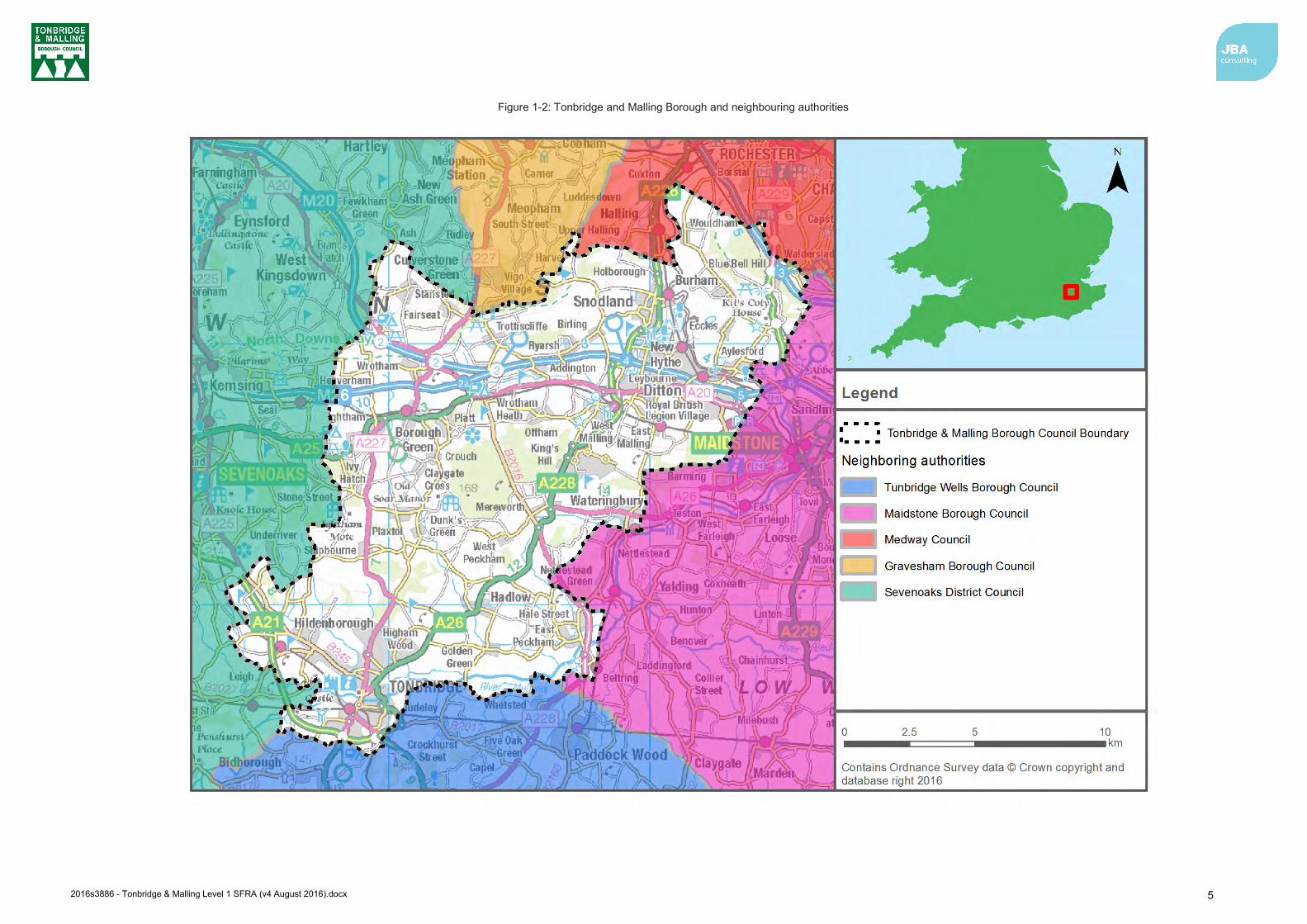
Figure 1-2: Tonbridge and Malling Borough and neighbouring authorities ........................ 5
Figure 2-1: Flood Risk Regulation Requirements .............................................................. 6
Figure 2-2: Flood risk and the preparation of Local Plans† ................................................ 10
Figure 2-3: Strategic planning links and key documents for flood risk ............................... 15
Figure 3-1: Use of SFRA information ................................................................................. 17
Figure 3-2: Concept of Flood Zones ................................................................................... 18
Figure 4-1: Applying the Sequential Test in the preparation of a Local Plan ..................... 23
Figure 4-2: Applying the Exception Test in the preparation of a Local Plan ...................... 23
Figure 5-1: Historical fluvial flooding records across Tonbridge and Malling Borough ...... 27
Figure 5-2: Tonbridge and Malling Borough Topography ................................................... 30
Figure 5-3: Bedrock deposits in Tonbridge and Malling Borough ...................................... 31
Figure 5-4: Superficial deposits in Tonbridge and Malling Borough ................................... 31
Figure 5-5: Surface water flooding records ........................................................................ 36
Figure 6-1: Location of defences within Tonbridge ............................................................ 43
Figure 6-2: Condition grade of defences within Tonbridge ................................................. 44
Figure 6-3: Design Standard of Protection for defences within Tonbridge ......................... 44
Figure 6-4: Location of defences downstream of Maidstone .............................................. 45
Figure 6-5: Condition grade of defences downstream of Maidstone .................................. 46
Figure 6-6: Design Standard of Protection for defences downstream of Maidstone .......... 46
Figure 6-7: Location of Leigh and East Peckham FSAs ..................................................... 47
Figure 8-1: Four pillars of SuDS design ............................................................................. 58
Figure 8-2: SuDS Management Train ................................................................................. 60
Figure 8-3: SuDS selection matrix for site conditions ......................................................... 62
Figure 8-4: Groundwater Source Protection Zones ............................................................ 65
Figure 8-5: Nitrate Vulnerable Zones ................................................................................. 66
2016s3886 - Tonbridge & Malling Level 1 SFRA (v4 August 2016).docx 2
List of Tables Table 1-1: SFRA report contents ........................................................................................ 4
Table 2-1: Roles and responsibilities in Tonbridge and Malling Borough .......................... 13
Table 3-1: Flood Zone descriptions .................................................................................... 18
Table 5-1: Main River watercourses in the borough ........................................................... 34
Table 5-2: SIRF database for the Tonbridge and Malling Borough .................................... 38
Table 5-3: Reservoirs that may potentially affect Tonbridge and Malling Borough in the event of a breach ............................................................................................... 38
Table 6-1: Defence asset condition rating .......................................................................... 42
Table 8-1: uFMfSW risk categories .................................................................................... 57
Table 8-2: Examples of SuDS techniques and potential benefits ...................................... 59
Table 9-1: Environment Agency Flood Warnings Explained .............................................. 68
Table 12-1: Site summary assessment – flood risk and spatial datasets .......................... 82
Using this document
Hyperlinks
Hyperlinks have been provided where there are useful reference points. These are shown as green bold text.
Contents, list of figures, list of tables and references to other sections, figures and tables have also been hyperlinked to enable easy navigation around the report.

2016s3886 - Tonbridge & Malling Level 1 SFRA (v4 August 2016).docx 3
Abbreviations and Glossary of Terms Term Definition
AEP Annual Exceedance Probability AStGWF Areas Susceptible to Groundwater Flooding Brownfield Previously developed parcel of land CC Climate change - Long term variations in global temperature and weather
patterns caused by natural and human actions. CFMP Catchment Flood Management Plan- A high-level planning strategy through
which the Environment Agency works with their key decision makers within a river catchment to identify and agree policies to secure the long-term sustainable management of flood risk.
CIRIA Construction Industry Research and Information Association Defra Department for Environment, Food and Rural Affairs Designated Feature A form of legal protection or status reserved for certain key structures or
features that are privately owned and maintained, but which make a contribution to the flood or coastal erosion risk management of people and property at a particular location.
DG5 Register A water-company held register of properties which have experienced sewer flooding due to hydraulic overload, or properties which are 'at risk' of sewer flooding more frequently than once in 20 years.
EA Environment Agency EU European Union FEH Flood Estimation Handbook Flood defence Infrastructure used to protect an area against floods as floodwalls and
embankments; they are designed to a specific standard of protection (design standard).
Flood Risk Area An area determined as having a significant risk of flooding in accordance with guidance published by Defra and WAG (Welsh Assembly Government).
Flood Risk Regulations Transposition of the EU Floods Directive into UK law. The EU Floods Directive is a piece of European Community (EC) legislation to specifically address flood risk by prescribing a common framework for its measurement and management.
Floods and Water Management Act
Part of the UK Government's response to Sir Michael Pitt's Report on the Summer 2007 floods, the aim of which is to clarify the legislative framework for managing surface water flood risk in England.
Fluvial Flooding Flooding resulting from water levels exceeding the bank level of a main river
FRA Flood Risk Assessment - A site specific assessment of all forms of flood risk to the site and the impact of development of the site to flood risk in the area.
FRMP Flood Risk Management Plan FWMA Flood and Water Management Act FZ Flood Zones GI Green Infrastructure – a network of natural environmental components and
green spaces that intersperse and connect the urban centres, suburbs and urban fringe
Greenfield Undeveloped parcel of land Ha Hectare Indicative Flood Risk Area
Nationally identified flood risk areas, based on the definition of ‘significant’ flood risk described by Defra and WAG.
JBA Jeremy Benn Associates LFRMS Local Food Risk Management Strategy
LLFA Lead Local Flood Authority - Local Authority responsible for taking the lead on local flood risk management
LPA Local Planning Authority mAOD metres Above Ordnance Datum Main River A watercourse shown as such on the Main River Map, and for which the

2016s3886 - Tonbridge & Malling Level 1 SFRA (v4 August 2016).docx 4
Term Definition
Environment Agency has responsibilities and powers NPPF National Planning Policy Framework Ordinary Watercourse All watercourses that are not designated Main River. Local Authorities or,
where they exist, IDBs have similar permissive powers as the Environment Agency in relation to flood defence work. However, the riparian owner has the responsibility of maintenance.
OS NGR Ordnance Survey National Grid Reference PFRA Preliminary Flood Risk Assessment Pluvial flooding Flooding as a result of high intensity rainfall when water is ponding or
flowing over the ground surface (surface runoff) before it enters the underground drainage network or watercourse, or cannot enter it because the network is full to capacity.
PPG National Planning Policy Guidance PPS25 Planning and Policy Statement 25: Development and Flood Risk –
superseded by the NPPF and PPG Resilience Measures Measures designed to reduce the impact of water that enters property and
businesses; could include measures such as raising electrical appliances. Resistance Measures Measures designed to keep flood water out of properties and businesses;
could include flood guards for example. Risk In flood risk management, risk is defined as a product of the probability or
likelihood of a flood occurring, and the consequence of the flood. Return Period Is an estimate of the interval of time between events of a certain intensity or
size, in this instance it refers to flood events. It is a statistical measurement denoting the average recurrence interval over an extended period of time.
Sewer flooding Flooding caused by a blockage or overflowing in a sewer or urban drainage system.
SHLAA Strategic Housing Land Availability Assessment - The Strategic Housing Land Availability Assessment (SHLAA) is a technical piece of evidence to support local plans and Sites & Policies Development Plan Documents (DPDs). Its purpose is to demonstrate that there is a supply of housing land in the Borough which is suitable and deliverable.
SFRA Strategic Flood Risk Assessment SoP Standard of Protection - Defences are provided to reduce the risk of
flooding from a river and within the flood and defence field standards are usually described in terms of a flood event return period. For example, a flood embankment could be described as providing a 1 in 100-year standard of protection.
Stakeholder A person or organisation affected by the problem or solution, or interested in the problem or solution. They can be individuals or organisations, includes the public and communities.
SuDS Sustainable Drainage Systems - Methods of management practices and control structures that are designed to drain surface water in a more sustainable manner than some conventional techniques
Surface water flooding Flooding as a result of surface water runoff as a result of high intensity rainfall when water is ponding or flowing over the ground surface before it enters the underground drainage network or watercourse, or cannot enter it because the network is full to capacity, thus causing what is known as pluvial flooding.
SWMP Surface Water Management Plan - The SWMP plan should outline the preferred surface water management strategy and identify the actions, timescales and responsibilities of each partner. It is the principal output from the SWMP study.
TMBC Tonbridge and Malling Borough Council
uFMfSW Updated Flood Map for Surface Water WFD Water Framework Directive
2016s3886 - Tonbridge & Malling Level 1 SFRA (v4 August 2016).docx 1
1 Introduction 1.1 Purpose of the Strategic Flood Risk Assessment
This Strategic Flood Risk Assessment (SFRA) 2016 document replaces the Level 1 SFRA originally published by Tonbridge and Malling Borough Council in August 2006 and updated in February 2011. The report has been prepared to replace the content that was included in the previous SFRA and to provide appropriate supporting evidence for the emerging Local Plan.
The 2016 SFRA update will be used in decision making and to inform decisions on the location of future development and the preparation of sustainable policies for the long-term management of flood risk.
The key objectives of the review performed during the preparation of the 2016 SFRA are:
1. To take into account the latest flood risk policy We have identified there is a need to ensure the assessment is up to date with reference to the following key changes to policy and guidance that have occurred since the existing SFRA was updated in 2011:
Changes to legislation, both relating to flood risk and planning policy, including the Flood Risk Regulations (2009), Flood and Water Management Act (2010), the National Planning Policy Framework (NPPF) (2012), the Localism Act (2011) and the Climate Change Act (2008); and new powers and responsibilities bestowed on Kent County Council as the Lead Local Flood Authority (LLFA) under the Flood and Water Management Act (2010) and their dependencies therefore with the Council’s local development and forward planning roles.
Recent guidance published in April 2015 regarding the role of LLFAs, Local Planning Authorities and the Environment Agency with regards to SuDS approval.
Changes to technical guidance, for example the Consultation on SuDS Regulations and Standards (2011), Defra’s Non-statutory technical standards for sustainable drainage systems (March 2015), and NPPF Planning Practice Guidance replacing PPS25 and PPG25, CIRIA SuDS Manual C753 (2015)
Latest guidance on climate change allowances for flood risk assessments released by the Environment Agency.
2. Take into account the latest flood risk information and available data
We have identified there have been a number of changes to available data that have occurred since the existing SFRA was updated in 2011:
Availability of the Environment Agency’s updated flood risk modelling of the North Kent Coast, including tidal River Medway (2013)
Availability of the Environment Agency’s updated flood risk modelling of the fluvial River Medway (2015)
Kent County Council Local Flood Risk Management Strategy (2013) Maidstone & Malling Surface Water Management Plan (2012) Tonbridge and Malling Surface Water Management Plan (2013) Availability of the updated Flood Map for Surface Water (uFMfSW)
3. To provide individual flood risk analysis for sites identified by the Council as part of their Local Plan preparation.
The new Local Plan will set out the Council’s spatial strategy to help guide and manage future development in the most sustainable way. The potential sites will require a detailed assessment if the SFRA is taken forward to a Level 2 SFRA. Under this Level 1 assessment, high level screening of potential sites against flood risk information has been summarised to enable Tonbridge and Malling Borough Council to better understand flood risk at sites within the Borough. These 210 sites were produced as part of the council’s ‘Call for Sites’ exercise in 2014 and 2015.
2016s3886 - Tonbridge & Malling Level 1 SFRA (v4 August 2016).docx 2
4. To provide a comprehensive set of maps including, but not limited to fluvial flood risk, including functional floodplain and climate change; surface water risk; groundwater risk; and flood warning coverage.
1.2 SFRA objectives The Planning Practice Guidance advocates a tiered approach to risk assessment and identifies the following two levels of SFRA:
Level 1: where flooding is not a major issue and where development pressures are low. The assessment should be sufficiently detailed to allow application of the Sequential Test.
Level 2: where land outside Flood Zones 2 and 3 cannot appropriately accommodate all the necessary development (see outputs from the Level 1 SFRA) creating the need to apply the NPPF’s Exception Test. In these circumstances the assessment should consider the detailed nature of the flood characteristics within a Flood Zone and assessment of other sources of flooding.
The objectives of this SFRA update are a Level 1 assessment.
1.3 SFRA outputs To meet the objectives, the following outputs have been prepared:
Appraisal of all potential sources of flooding, including Main River, Ordinary Watercourse, surface water and groundwater.
Updated review of historical flooding incidents. Mapping of location and extent of functional floodplain. Reporting on the standard of protection provided by existing flood risk management
infrastructure. An assessment of the potential increase in flood risk due to climate change. Areas at risk from other sources of flooding, for example surface water or reservoirs. An assessment of the impact of future large-scale developments both within and
outside the Tonbridge and Malling Borough. An assessment of existing flood warning and emergency planning procedures,
including an assessment of safe access and egress during an extreme event. Recommendations of the criteria that should be used to assess future development
proposals and the development of a Sequential Test and sequential approach to flood risk.
High level screening of proposed development sites against flood risk information.
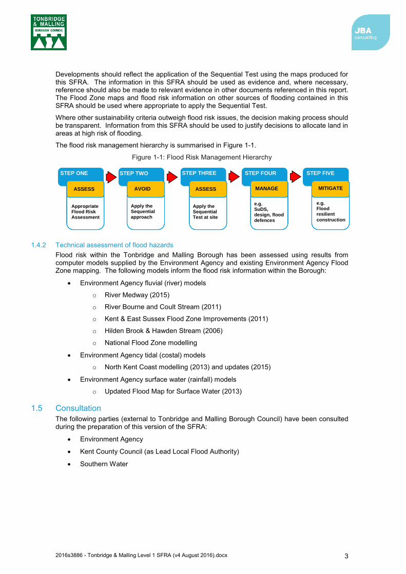
1.4 Approach
1.4.1 General assessment of flood risk The flood risk management hierarchy underpins the risk-based approach and is the basis for making all decisions involving development and flood risk. When using the hierarchy, account should be taken of
the nature of the flood risk (the source of the flooding); the spatial distribution of the flood risk (the pathways and areas affected by
flooding); climate change impacts; and the degree of vulnerability of different types of development (the receptors).
2016s3886 - Tonbridge & Malling Level 1 SFRA (v4 August 2016).docx 3
Developments should reflect the application of the Sequential Test using the maps produced for this SFRA. The information in this SFRA should be used as evidence and, where necessary, reference should also be made to relevant evidence in other documents referenced in this report. The Flood Zone maps and flood risk information on other sources of flooding contained in this SFRA should be used where appropriate to apply the Sequential Test.
Where other sustainability criteria outweigh flood risk issues, the decision making process should be transparent. Information from this SFRA should be used to justify decisions to allocate land in areas at high risk of flooding.
The flood risk management hierarchy is summarised in Figure 1-1.
Figure 1-1: Flood Risk Management Hierarchy
1.4.2 Technical assessment of flood hazards Flood risk within the Tonbridge and Malling Borough has been assessed using results from computer models supplied by the Environment Agency and existing Environment Agency Flood Zone mapping. The following models inform the flood risk information within the Borough:
Environment Agency fluvial (river) models
o River Medway (2015)
o River Bourne and Coult Stream (2011)
o Kent & East Sussex Flood Zone Improvements (2011)
o Hilden Brook & Hawden Stream (2006)
o National Flood Zone modelling
Environment Agency tidal (costal) models
o North Kent Coast modelling (2013) and updates (2015)
Environment Agency surface water (rainfall) models
o Updated Flood Map for Surface Water (2013)
1.5 Consultation The following parties (external to Tonbridge and Malling Borough Council) have been consulted during the preparation of this version of the SFRA:
Environment Agency
Kent County Council (as Lead Local Flood Authority)
Southern Water
STEP ONE STEP TWO STEP THREE STEP FOUR STEP FIVE
ASSESS AVOID ASSESS MANAGE MITIGATE
Appropriate Flood Risk Assessment
Apply the Sequential approach
Apply the Sequential Test at site
e.g. SuDS, design, flood defences
e.g. Flood resilient
construction
2016s3886 - Tonbridge & Malling Level 1 SFRA (v4 August 2016).docx 4
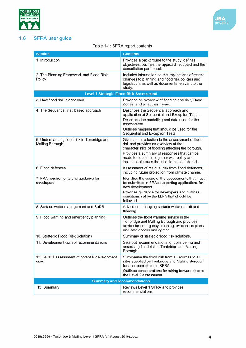
1.6 SFRA user guide Table 1-1: SFRA report contents
Section Contents
1. Introduction Provides a background to the study, defines objectives, outlines the approach adopted and the consultation performed.
2. The Planning Framework and Flood Risk Policy
Includes information on the implications of recent changes to planning and flood risk policies and legislation, as well as documents relevant to the study.
Level 1 Strategic Flood Risk Assessment
3. How flood risk is assessed Provides an overview of flooding and risk, Flood Zones, and what they mean.
4. The Sequential, risk based approach Describes the Sequential approach and application of Sequential and Exception Tests. Describes the modelling and data used for the assessment. Outlines mapping that should be used for the Sequential and Exception Tests
5. Understanding flood risk in Tonbridge and Malling Borough
Gives an introduction to the assessment of flood risk and provides an overview of the characteristics of flooding affecting the borough. Provides a summary of responses that can be made to flood risk, together with policy and institutional issues that should be considered.
6. Flood defences Assessment of residual risk from flood defences, including future protection from climate change.
7. FRA requirements and guidance for developers
Identifies the scope of the assessments that must be submitted in FRAs supporting applications for new development. Provides guidance for developers and outlines conditions set by the LLFA that should be followed.
8. Surface water management and SuDS Advice on managing surface water run-off and flooding
9. Flood warning and emergency planning Outlines the flood warning service in the Tonbridge and Malling Borough and provides advice for emergency planning, evacuation plans and safe access and egress.
10. Strategic Flood Risk Solutions Summary of strategic flood risk solutions. 11. Development control recommendations Sets out recommendations for considering and
assessing flood risk in Tonbridge and Malling Borough
12. Level 1 assessment of potential development sites
Summarise the flood risk from all sources to all sites supplied by Tonbridge and Malling Borough for assessment in the SFRA. Outlines considerations for taking forward sites to the Level 2 assessment.
Summary and recommendations
13. Summary Reviews Level 1 SFRA and provides recommendations
2016s3886 - Tonbridge & Malling Level 1 SFRA (v4 August 2016).docx 5
Figure 1-2: Tonbridge and Malling Borough and neighbouring authorities

2016s3886 - Tonbridge & Malling Level 1 SFRA (v4 August 2016).docx 6
2 The Planning Framework and Flood Risk Policy 2.1 Introduction
The overarching aim of development and flood risk planning policy in the UK is to ensure that the potential risk of flooding is taken into account at every stage of the planning process. This section of the SFRA provides an overview of the planning framework, flood risk policy and flood risk responsibilities. In preparing the subsequent sections of this SFRA, appropriate planning and policy amendments have been acknowledged and taken into account.
2.2 Flood Risk Regulations (2009) and Flood and Water Management Act (2010)
2.2.1 Flood Risk Regulations, 2009 The Flood Risk Regulations (2009) are intended to translate the current EU Floods Directive into UK law and place responsibility upon all Lead Local Flood Authorities (LLFAs) to manage localised flood risk. Under the Regulations, the responsibility for flooding from rivers, the sea and reservoirs lies with the Environment Agency. However, responsibility for local and all other sources of flooding rests with LLFAs. In the instance of this SFRA, the LLFA is Kent County Council.
Figure 2-1 illustrates the steps that have / are being taken to implement the requirements of the EU Directive in the UK via the Flood Risk Regulations.
Figure 2-1: Flood Risk Regulation Requirements
Under this action plan and in accordance with the Regulations, LLFAs had the task of preparing a Preliminary Flood Risk Assessment (PFRA) report. The PFRA document that covers the borough was published by Kent County Council in 20111.
1 Kent County Council PFRA (2011): http://www.kent.gov.uk/about-the-council/strategies-and-policies/environment-waste-and-planning-policies/flooding-and-drainage-policies/preliminary-flood-risk-assesment
PFRA Report (2011)
Preparation of Flood Hazard and Flood Risk Maps
(2013)
Identification of Flood Risk Areas
(FRAs)
Preliminary Flood Risk Assessment
(PFRA)
Preparation of Flood Risk
Management Plans (2015)

2016s3886 - Tonbridge & Malling Level 1 SFRA (v4 August 2016).docx 7
Under the Regulations the Environment Agency exercised an ‘Exception’ and did not prepare a PFRA for risk from rivers, reservoirs and the sea. This then made it a requirement for the Environment Agency to prepare and publish a Flood Risk Management Plan (FRMP). The FRMP process adopts the same catchments as used in the preparation of River Basin Management Plans, in accordance with the Water Framework Directive. Accordingly, more detailed strategic information on proposed strategic measures and approaches can be found in the Thames River Basin District Flood Risk Management Plan - Parts A, B, C and D2. The FRMP draws on previous policies and actions identified in Catchment Flood Management Plans and also incorporates information from Local Flood Risk Management Strategies. All of the London Boroughs and 17 contributing catchments covered by the Thames River Basin, and Tonbridge and Malling lies primarily within the Medway catchment area and a small part of the Darent and Cray catchment area north of the M20 at Wrotham. The FRMP summarises the flooding affecting the area and describes the measures to be taken to address the risk in accordance with the Flood Risk Regulations.
2.2.2 Flood and Water Management Act, 2010 The Flood and Water Management Act (2010)3 aims to create a simpler and more effective means of managing both flood risk and coastal erosion and implements Sir Michael Pitt’s recommendations following his review of the 2007 floods. The FWMA received Royal Assent in April 2010.
Kent County Council as LLFA has developed a Local Flood Risk Management Strategy under the Act, in consultation with local partners. This is discussed further in Section 2.2.5. This Strategy acts as the basis and discharge of duty for Flood Risk Management co-ordinated by Kent County Council. The final version of the strategy was published for June 2013.
Local authorities are responsible for flooding management relating to ‘Ordinary Watercourses’ (i.e. smaller ditches, brooks), with the Environment Agency responsible for ‘Main Rivers’.
When considering planning applications, Local Planning Authorities should consult LLFAs on the management of surface water in order to satisfy that:
the proposed minimum standards of operation are appropriate through the use of planning conditions or planning obligations, there are clear
arrangements for on-going maintenance over the development’s lifetime. The FWMA will also update the Reservoirs Act 1975 by reducing the capacity of reservoir regulation from 25,000m3 to 10,000m3. Phase 1 has been implemented in 2013 requiring large raised reservoirs to be registered to allow the Environment Agency to categorise whether they are ‘high risk’ or ‘not high risk’.
2.2.3 Lead Local Flood Authorities The FWMA established Lead Local Flood Authorities (LLFAs). Kent County Council is the LLFA for the Tonbridge and Malling Borough Council administrative area. Duties for LLFAs include:
Local Flood Risk Management Strategy (LFRMS): LLFAs must develop, maintain, apply and monitor an LFRMS to outline how they will manage flood risk, identify areas vulnerable to flooding and target resources where they are needed most.
Flood Investigations: When appropriate and necessary, LLFAs must investigate and report on flooding incidents (Section 19 investigations).
Register of Flood Risk Features: LLFAs must establish and maintain a register of structures or features which, in their opinion, are likely to have a significant effect on flood risk in the LLFA area.
Designation of Features: LLFAs may exercise powers to designate structures and features that affect flood risk, requiring the owner to seek consent from the authority to alter, remove or replace it.
2 Environment Agency, Thames River Basin District Flood Risk Management Plan 2015-2021 Part C (March 2016). Available: https://www.gov.uk/government/uploads/system/uploads/attachment_data/file/507148/LIT_10231_THAMES_ FRMP_PART_C.pdf 3 Flood and Water Management Act (2010): http://www.legislation.gov.uk/ukpga/2010/29/pdfs/ukpga_20100029_en.pdf

2016s3886 - Tonbridge & Malling Level 1 SFRA (v4 August 2016).docx 8
Consenting: When appropriate LLFAs will perform consenting of works on Ordinary Watercourses.
On 18 December 2014 a Written Ministerial Statement laid by the Secretary of State for Communities and Local Government set out changes to the planning process that would apply for major development from 6 April 2015. In considering planning applications, local planning authorities should consult the LLFA on the management of surface water, satisfy themselves that the proposed minimum standards of operation are appropriate and ensure, and through use of planning conditions or obligations, that there are clear arrangements in place for ongoing maintenance over the lifetime of the development.
In March 2015 the LLFA was made a statutory consultee which came into effect on 15 April 2015. As a result, Kent County Council, will be required to provide technical advice on surface water drainage strategies and designs put forward for new major developments.
Major developments are defined as
Residential development: 10 dwellings or more, or residential development with a site area of 0.5 hectares or more where the number of dwellings is not yet known; and
Non-residential development: provision of a building or buildings where the total floor space to be created is 1,000 square metres or more or, where the floor area is not yet known, a site area of 1 hectare or more.
2.2.4 Kent Preliminary Flood Risk Assessment (2011) The Flood Risk Regulations required Kent County Council (as the LLFA) to prepare and publish a Preliminary Flood Risk Assessment (PFRA) on past and future flood risk from sources of flooding. The PFRA reports on significant past and future flooding from all sources except from Main Rivers and Reservoirs, which are covered by the Environment Agency, and sub-standard performance of the adopted sewer network (covered under the remit of Southern Water).
The PFRA is a high-level screening exercise and considers floods which have significant harmful consequences for human health, economic activity, the environment and cultural heritage. The Regulations require the LLFA to identify significant Flood Risk Areas. The threshold for designating significant flood Risk Areas is defined by Defra and the PFRA is the process by which these locations can be identified. Of the ten national indicative Flood Risk Areas that were identified by the Defra/Environment Agency, none encroach on the administrative area of Tonbridge and Malling Borough Council and the indicative designations have been accepted.
No Flood Risk Areas have been identified based on critical infrastructure/access routes, sewer/surface water problems and areas prone to significant ponding.
2.2.5 Kent Local Flood Risk Management Strategy (2013)4 Kent County Council is responsible for developing, maintaining, applying and monitoring a LFRMS for Kent, which covers the Tonbridge and Malling Borough. The Strategy is used as a means by which the LLFA (Kent County Council) co-ordinates Flood Risk Management on a day to day basis. The Strategy also sets measures to manage local flood risk i.e. flood risk from surface water, groundwater and Ordinary Watercourses. The Environment Agency is responsible for managing flooding from main rivers and reservoirs, with the LLFA responsible for managing Ordinary Watercourses. The high-level objectives proposed in the Strategy for managing flood risk are:
1. Understanding flood risk in Kent 2. Managing the likelihood of flooding 3. Helping Kent’s citizens to manage their own risk 4. Ensuring appropriate development in Kent 5. Improving flood prediction, warning and post flood recovery
4 http://www.kent.gov.uk/about-the-council/strategies-and-policies/environment-waste-and-planning-policies/flooding-and-drainage-policies/kent-flood-risk-management-plan

2016s3886 - Tonbridge & Malling Level 1 SFRA (v4 August 2016).docx 9
The Strategy also sets out an action plan of how the LLFA intends to achieve these objectives. The action plan contains the following information:
A description of the action. The objective the action relates to. The driver behind the action. The organisation with key accountability. Supporting organisations. The funding source. When the action was added. Timescale for completion or current status.
The Strategy should be updated regularly or when key triggers are activated. An example of a key trigger would be issues such as amendments to partner responsibilities, updates to legislation, alterations in the nature or understanding of flood risk or a significant flood event, may also require the update of the Strategy and action plan.
2.3 National Planning Policy Framework The National Planning Policy Framework (NPPF)5 was issued on 27 March 2012 to replace the previous documentation as part of reforms to, firstly, make the planning system less complex and more accessible, and, secondly, to protect the environment and promote sustainable growth. It replaces most of the Planning Policy Guidance Notes (PPGs) and Planning Policy Statements (PPSs) that were referred to in the previous version of the SFRA. The NPPF is a source of guidance for local planning authorities to help them prepare Local Plans and for applicants preparing planning submissions.
Paragraph 100 of the NPPF:
Planning Practice Guidance on flood risk was published in March 2014 and sets out how the policy should be implemented. NPPF sets out Flood Zones, the appropriate land uses for each zone, flood risk assessment requirements and the policy aims for developers and authorities regarding each Flood Zone. Further details on Flood Zones and associated policy is provided in Table 3-1 and throughout this report.
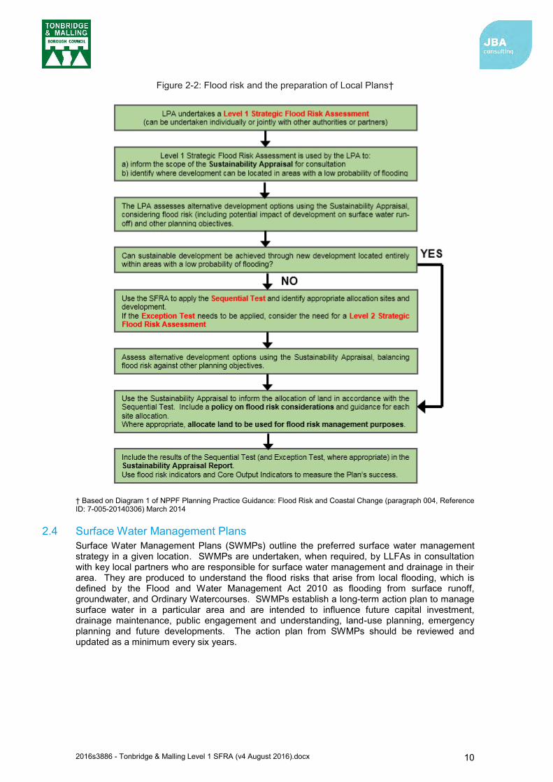
A description of how flood risk should be taken into account in the preparation of Local Plans is outlined in Diagram 1 contained within the Planning Practice Guidance (Figure 2-2).
5 National Planning Policy Framework (Department for Communities and Local Government, March 2012)
“Local Plans should be supported by a strategic flood risk assessment and develop policies to manage flood risk from all sources, taking account of advice from the Environment Agency and other relevant flood risk management bodies, such as Lead Local Flood Authorities and Internal Drainage Boards. Local Plans should apply a sequential, risk-based approach to the location of development to avoid, where possible, flood risk to people and property and manage any residual risk, taking account of the impacts of climate change”.
2016s3886 - Tonbridge & Malling Level 1 SFRA (v4 August 2016).docx 10
Figure 2-2: Flood risk and the preparation of Local Plans†
† Based on Diagram 1 of NPPF Planning Practice Guidance: Flood Risk and Coastal Change (paragraph 004, Reference ID: 7-005-20140306) March 2014
2.4 Surface Water Management Plans Surface Water Management Plans (SWMPs) outline the preferred surface water management strategy in a given location. SWMPs are undertaken, when required, by LLFAs in consultation with key local partners who are responsible for surface water management and drainage in their area. They are produced to understand the flood risks that arise from local flooding, which is defined by the Flood and Water Management Act 2010 as flooding from surface runoff, groundwater, and Ordinary Watercourses. SWMPs establish a long-term action plan to manage surface water in a particular area and are intended to influence future capital investment, drainage maintenance, public engagement and understanding, land-use planning, emergency planning and future developments. The action plan from SWMPs should be reviewed and updated as a minimum every six years.
2016s3886 - Tonbridge & Malling Level 1 SFRA (v4 August 2016).docx 11
Surface Water Management Plans (SWMPs) applicable to the Tonbridge and Malling area are listed below, with links provided to these documents.
- Tonbridge and Malling Stage 1 SWMP6 (2013)
- Maidstone and Malling Stage 1 SWMP7 (2012)
The outcomes and actions from each of these SWMPs should be considered in the context of proposed developments within the area of Tonbridge and Malling Borough
2.5 Catchment Flood Management Plans Catchment Flood Management Plans (CFMPs) are a high-level strategic plan providing an overview of flood risk across each river catchment. The Environment Agency use CFMPs to work with other key-decision makers to identify and agree long-term policies for sustainable flood risk management.
There are six pre-defined national policies provided in the CFMP guidance and these are applied to specific locations through the identification of ‘Policy Units’. These policies are intended to cover the full range of long-term flood risk management options that can be applied to different locations in the catchment.
The six national policies are:
1. No active intervention (including flood warning and maintenance). Continue to monitor and advise.
2. Reducing existing flood risk management actions (accepting that flood risk will increase over time).
3. Continue with existing or alternative actions to manage flood risk at the current level (accepting that flood risk will increase over time from this baseline).
4. Take further action to sustain the current level of flood risk (responding to the potential increases in risk from urban development, land use change and climate change).
5. take action to reduce flood risk (now and/or in the future) 6. Take action with others to store water or manage run-off in locations that provide overall
flood risk reduction or environmental benefits, locally or elsewhere in the catchment.
2.5.1 River Medway CFMP (2009) The borough is covered by the River Medway CFMP8. The primary policy units for Tonbridge and Malling are:
Sub Area 1: Upper catchment – Policy Option 3 Sub Area 4: Tonbridge – Policy Option 5 Sub Area 5: Collier Street/Yalding/East Peckham – Policy Option 5 Sub Area 8: Lower Medway – Policy Option 3
Policy Option 3 is for areas of low to moderate flood risk where the Environment Agency are generally managing existing flood risk effectively.
Policy Option 5 is for areas of moderate to high flood risk where the Environment Agency can generally take further action to reduce flood risk.
The CFMP provides a starting point for measures being considered strategically to manage flood risk within its area. To that end, an important consideration of the NPPF for Tonbridge and Malling Borough relates to safeguarding land from development that is required for current and future flood management (paragraph 100).
6 http://www.kent.gov.uk/about-the-council/strategies-and-policies/environment-waste-and-planning-policies/flooding-and-drainage-policies/surface-water-management-plans/tonbridge-and-malling-surface-water-management-plan 7 http://www.kent.gov.uk/about-the-council/strategies-and-policies/environment-waste-and-planning-policies/flooding-and-drainage-policies/surface-water-management-plans/maidstone-and-malling-surface-water-management-plan 8 https://www.gov.uk/government/uploads/system/uploads/attachment_data/file/293890/Medway_Catchment_Flood_ Management_Plan.pdf

2016s3886 - Tonbridge & Malling Level 1 SFRA (v4 August 2016).docx 12
2.6 River Basin Management Plans River Basin Management Plans (RBMPs) are prepared under the Water Framework Directive (WFD) and assesses the pressure facing the water environment in River Basin Districts. The WFD aims to achieve at least 'good' status for all water bodies by 2015. The Tonbridge and Malling Borough Council area falls within the Thames River Basin District.
2.6.1 Thames River Basin Management Plan (2015) The second cycle of The Thames RBMP9 was published in February 2016, replacing the previous version published in 2009. The document provides information on the following:
Current state of the water environment Pressures affecting the water environment Environmental objectives for protecting and improving waters Programme of measures. And actions needed to achieve the objectives Progress since the 2009 plan
The Thames RBMP identified a number of significant water management issues, including:
Physical modifications Pollution from waste water Pollution from towns, cities and transport Changes to the natural flow and level of water Negative effects of invasive non-native species Pollution from rural areas
The RBMP describes how development planning needs to consider a number of issues relevant to the RBMP including housing locations, sewage treatment options, initiatives to reduce flow to sewage works, water efficiency measures and the reduction of nutrients from diffuse pollution.
The RBMP notes that 11% of water bodies in the Thames River Basin District currently have a ‘good or better’ overall status, which is expected to increase to 13% by 2021. However, this ‘good or better’ overall status is forecast to increase notably for the extended deadline of 2027 reported in the RBMP.
2.7 Shoreline Management Plan The Shoreline Management Plan (SMP) forms part of the Defra’s strategy for flood and coast defence. It provides a large-scale assessment of risks associated with coastal evolution and presents the policy framework to address these risks in a sustainable manner. The SMP policies are defined by Defra are:
Hold the line – maintain or upgrade the level of protection provided by defences.
Advance the line – build new defences seawards of the existing defence line.
Managed realignment – allowing retreat of the shoreline, with management to control or limit the management.
No active intervention – a decision not to invest in providing or maintaining defences.
The tidal Medway that lies within Tonbridge and Malling’s administrative boundary is covered by the Medway Estuary and Swale SMP10.
9https://www.gov.uk/government/uploads/system/uploads/attachment_data/file/500548/Thames_RBD_Part_1_river_basin_management_plan.pdf 10 Kent County Council: Flood Risk to Communities Tonbridge and Malling (March 2016)
2016s3886 - Tonbridge & Malling Level 1 SFRA (v4 August 2016).docx 13
2.7.1 Medway Estuary and Swale SMP (2010) The Shoreline Management Plan for Medway Estuary and Swale covers the Tidal Medway in the Tonbridge and Malling borough from Holborough upstream to Allington Lock11. The SMP Policy units within the borough are E408, E409 and E410. The policy identified for all three units in the borough is to investigate the potential for a managed realignment.
2.8 Association of British Insurers Guidance on Insurance and Planning in Flood Risk Areas for Local Planning Authorities in England The Association of British Insurers (ABI) and the National Flood Forum have published guidance for Local Authorities with regards to planning in flood risk areas12. The guidance aims to assist Local Authorities in England in producing local plans and dealing with planning applications in flood risk areas. The guidance complements the National Planning Policy Framework. The key recommendations from the guidance are:
Ensure strong relationships with technical experts on flood risk. Consider flooding from all sources, taking account of climate change. Take potential impacts on drainage infrastructure seriously. Ensure that flood risk is mitigated to acceptable levels for proposed developments. Make sure Local Plans take account of all relevant costs and are regularly reviewed.
2.9 Implications for Tonbridge and Malling The new and emerging responsibilities under the Flood and Water Management Act 2010 and the Flood Risk Regulations 2009 are summarised in Table 2-1.
Table 2-1: Roles and responsibilities in Tonbridge and Malling Borough
Risk Management Authority (RMA)
Strategic
Level
Operational Level
Environment Agency
National Statutory Strategy Reporting and supervision (overview role)
Preliminary Flood Risk Assessment (per River Basin District)*
Managing flooding from main rivers and reservoirs and communication flood risk warnings to the public, media and partner organisations.
Identifying Significant Flood Risk Area* Preparation of Flood Risk and Hazard Maps Preparation of Flood Risk Management Plan Enforcement authority for Reservoirs Act 1975 Managing RFCCs and supporting funding
decisions, working with LLFAs and communities. Emergency planning and multi-agency flood plans,
developed by local resilience forums
Lead Local Flood Authority (Kent County Council)
Input to National Strategy. Formulate and implement Local Flood Risk Management Strategy.
Responsible for enforcing and consenting works for Ordinary Watercourses, risk assessing Ordinary Watercourses.
Managing local sources of flooding from surface water runoff and groundwater and carrying out practical works to manage flood risk from these sources where necessary.
Preparing and publishing a PFRA Identifying Flood Risk Areas Preparing Flood Hazard and Flood Risk Maps Preparing Flood Risk Management Plans (where
local flood risk is significant) Investigating certain incidents of flooding in
11 Environment Agency: Medway Estuary and Swale Shoreline Management Plan (2010) 12 Guidance on Insurance and Planning in Flood Risk Areas for Local Planning Authorities in England (Association of British Insurers and National Flood Forum, April 2012)
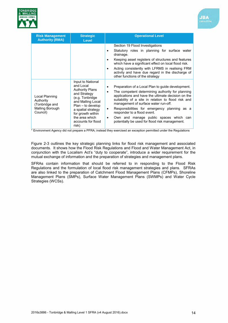
2016s3886 - Tonbridge & Malling Level 1 SFRA (v4 August 2016).docx 14
Risk Management Authority (RMA)
Strategic
Level
Operational Level
Section 19 Flood Investigations Statutory roles in planning for surface water
drainage. Keeping asset registers of structures and features
which have a significant effect on local flood risk. Acting consistently with LFRMS in realising FRM
activity and have due regard in the discharge of other functions of the strategy
Local Planning Authority (Tonbridge and Malling Borough Council)
Input to National and Local Authority Plans and Strategy (e.g. Tonbridge and Malling Local Plan – to develop a spatial strategy for growth within the area which accounts for flood risk)
Preparation of a Local Plan to guide development. The competent determining authority for planning
applications and have the ultimate decision on the suitability of a site in relation to flood risk and management of surface water run-off.
Responsibilities for emergency planning as a responder to a flood event.
Own and manage public spaces which can potentially be used for flood risk management.
* Environment Agency did not prepare a PFRA; instead they exercised an exception permitted under the Regulations
Figure 2-3 outlines the key strategic planning links for flood risk management and associated documents. It shows how the Flood Risk Regulations and Flood and Water Management Act, in conjunction with the Localism Act’s “duty to cooperate”, introduce a wider requirement for the mutual exchange of information and the preparation of strategies and management plans.
SFRAs contain information that should be referred to in responding to the Flood Risk Regulations and the formulation of local flood risk management strategies and plans. SFRAs are also linked to the preparation of Catchment Flood Management Plans (CFMPs), Shoreline Management Plans (SMPs), Surface Water Management Plans (SWMPs) and Water Cycle Strategies (WCSs).
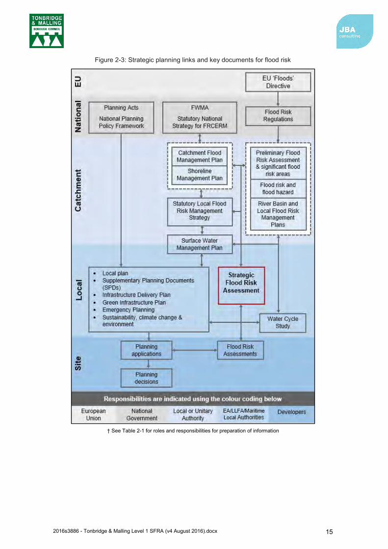
2016s3886 - Tonbridge & Malling Level 1 SFRA (v4 August 2016).docx 15
Figure 2-3: Strategic planning links and key documents for flood risk
† See Table 2-1 for roles and responsibilities for preparation of information
2016s3886 - Tonbridge & Malling Level 1 SFRA (v4 August 2016).docx 16
3 How flood risk is assessed 3.1 Definitions
3.1.1 Flood Section1 (subsection 1) of the Flood and Water Management Act (FWMA) (2010)13 defines a flood as:
Section 1 (subsection 2) states that ‘it does not matter for the purposes of subsection (1)’ whether a flood is caused by
a. heavy rainfall; b. a river overflowing or its banks being breached; c. a dam overflowing or being breached; d. tidal waters; e. groundwater; or f. anything else (including any combination of factors).
Note: Sources of flooding under this definition do not include excess surface water from any part of a sewerage system, unless caused by an increase in the volume of rainwater entering or affecting the system, or a flood caused by a burst water main.
3.1.2 Flood Risk Section 3 (subsection 1) of the FWMA defines the risk of a potentially harmful event (such as flooding) as:
Thus it is possible to summarise flood risk as:
Flood Risk = (Probability of a flood) x (Scale of the consequences)
On that basis it is useful to express the definition as follows:
Using this definition it can be seen that:
Increasing the probability or chance of a flood being experienced increases the flood risk: In situations where the probability of a flood being experienced increases gradually over time, for example due to the effects of climate change, then the severity of the flood risk will increase (flooding becomes more frequent or has increased effect).
13 Flood and Water Management Act (2010): http://www.legislation.gov.uk/ukpga/2010/29/pdfs/ukpga_20100029_en.pdf
‘any case where land not normally covered by water becomes covered by water’
‘a risk in respect of an occurrence is assessed and expressed (as for insurance and scientific purposes) as a combination of the probability of the occurrence with its potential consequences.’
Flood Risk
Probability Flood Hazard
Magnitude
Receptor
Presence
Receptor
Vulnerability
Consequences

2016s3886 - Tonbridge & Malling Level 1 SFRA (v4 August 2016).docx 17
The potential scale of the consequences in a given location can increase the flood risk:
o Flood Hazard Magnitude: If the direct hazard posed by the depth of flooding, velocity of flow, the speed of onset, rate of risk in flood water or duration of inundation is increased, then the consequences of flooding, and therefore risk, is increased.
o Receptor Presence: The consequences of a flood will be increased if there are more receptors affected, for example with an increase in extent or frequency of flooding. Additionally, if there is new development that increases the probability of flooding (for example, increase in volume of runoff due to increased impermeable surfaces) or increased density of infrastructure then consequences will also be increased.
o Receptor Vulnerability: If the vulnerability of the people, property or infrastructure is increased then the consequences are increased. For example, old or young people are more vulnerable in the event of a flood.
3.2 Using SFRA risk information This SFRA contains information that can be used at strategic, operational and tactical levels as shown by Figure 3-1.
Figure 3-1: Use of SFRA information
The SFRA will complement the Kent Local Flood Risk Management Strategy (2013)14 and will assist the LLFA with the stated objectives.
The assessment of flood risk in the SFRA is primarily based on the following three types of information:
1. Flood zones 2. Actual flood risk 3. Residual risk
3.2.1 Flood Zones The SFRA includes maps that show the Flood Zones. These zones describe the land that would flood if there were no defences present. A concept diagram showing the classification of Flood Zones graphically is included in Figure 3-2 below. The Government’s Planning Practice Guidance identifies the following Flood Zones (see Table 3-1). These apply to both Main River and Ordinary Watercourses.
The preference when allocating land is, whenever possible, to place all new development on land in Zone 1. Since the Flood Zones identify locations that are not reliant on flood defences, placing development on Zone 1 land means there is no future commitment to spending money on flood banks or flood alleviation measures. It also does not commit future generations to
14 http://www.kent.gov.uk/about-the-council/strategies-and-policies/environment-waste-and-planning-policies/flooding-and-drainage-policies/kent-flood-risk-management-plan
Assess risk Avoid or
reduce risk
Control or
mitigate risk
Tactical response
to flood event
Post event
recovery support
Before a flood During a flood After a flood
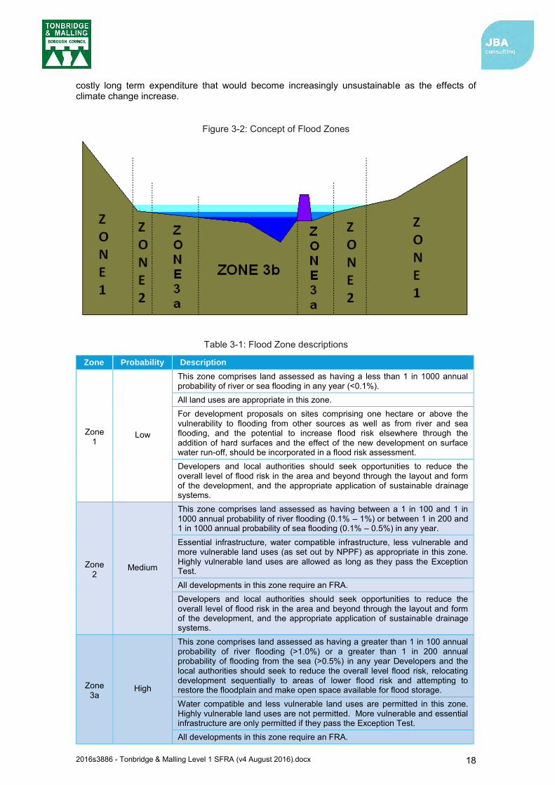
2016s3886 - Tonbridge & Malling Level 1 SFRA (v4 August 2016).docx 18
costly long term expenditure that would become increasingly unsustainable as the effects of climate change increase.
Figure 3-2: Concept of Flood Zones
Table 3-1: Flood Zone descriptions
Zone Probability Description
Zone 1
Low
This zone comprises land assessed as having a less than 1 in 1000 annual probability of river or sea flooding in any year (<0.1%). All land uses are appropriate in this zone. For development proposals on sites comprising one hectare or above the vulnerability to flooding from other sources as well as from river and sea flooding, and the potential to increase flood risk elsewhere through the addition of hard surfaces and the effect of the new development on surface water run-off, should be incorporated in a flood risk assessment. Developers and local authorities should seek opportunities to reduce the overall level of flood risk in the area and beyond through the layout and form of the development, and the appropriate application of sustainable drainage systems.
Zone 2
Medium
This zone comprises land assessed as having between a 1 in 100 and 1 in 1000 annual probability of river flooding (0.1% – 1%) or between 1 in 200 and 1 in 1000 annual probability of sea flooding (0.1% – 0.5%) in any year.
Essential infrastructure, water compatible infrastructure, less vulnerable and more vulnerable land uses (as set out by NPPF) as appropriate in this zone. Highly vulnerable land uses are allowed as long as they pass the Exception Test. All developments in this zone require an FRA. Developers and local authorities should seek opportunities to reduce the overall level of flood risk in the area and beyond through the layout and form of the development, and the appropriate application of sustainable drainage systems.
Zone 3a
High
This zone comprises land assessed as having a greater than 1 in 100 annual probability of river flooding (>1.0%) or a greater than 1 in 200 annual probability of flooding from the sea (>0.5%) in any year Developers and the local authorities should seek to reduce the overall level flood risk, relocating development sequentially to areas of lower flood risk and attempting to restore the floodplain and make open space available for flood storage. Water compatible and less vulnerable land uses are permitted in this zone. Highly vulnerable land uses are not permitted. More vulnerable and essential infrastructure are only permitted if they pass the Exception Test. All developments in this zone require an FRA.
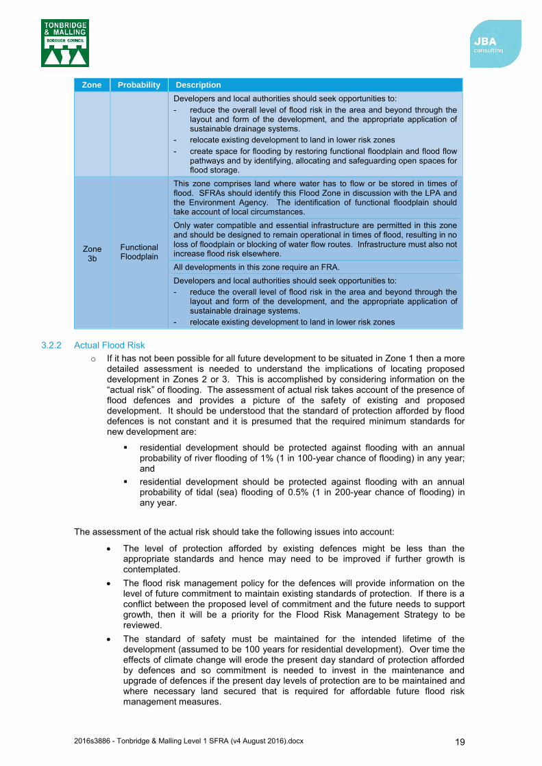
2016s3886 - Tonbridge & Malling Level 1 SFRA (v4 August 2016).docx 19
Zone Probability Description
Developers and local authorities should seek opportunities to: - reduce the overall level of flood risk in the area and beyond through the
layout and form of the development, and the appropriate application of sustainable drainage systems.
- relocate existing development to land in lower risk zones - create space for flooding by restoring functional floodplain and flood flow
pathways and by identifying, allocating and safeguarding open spaces for flood storage.
Zone 3b
Functional Floodplain
This zone comprises land where water has to flow or be stored in times of flood. SFRAs should identify this Flood Zone in discussion with the LPA and the Environment Agency. The identification of functional floodplain should take account of local circumstances. Only water compatible and essential infrastructure are permitted in this zone and should be designed to remain operational in times of flood, resulting in no loss of floodplain or blocking of water flow routes. Infrastructure must also not increase flood risk elsewhere. All developments in this zone require an FRA. Developers and local authorities should seek opportunities to: - reduce the overall level of flood risk in the area and beyond through the
layout and form of the development, and the appropriate application of sustainable drainage systems.
- relocate existing development to land in lower risk zones
3.2.2 Actual Flood Risk o If it has not been possible for all future development to be situated in Zone 1 then a more
detailed assessment is needed to understand the implications of locating proposed development in Zones 2 or 3. This is accomplished by considering information on the “actual risk” of flooding. The assessment of actual risk takes account of the presence of flood defences and provides a picture of the safety of existing and proposed development. It should be understood that the standard of protection afforded by flood defences is not constant and it is presumed that the required minimum standards for new development are:
residential development should be protected against flooding with an annual probability of river flooding of 1% (1 in 100-year chance of flooding) in any year; and
residential development should be protected against flooding with an annual probability of tidal (sea) flooding of 0.5% (1 in 200-year chance of flooding) in any year.
The assessment of the actual risk should take the following issues into account:
The level of protection afforded by existing defences might be less than the appropriate standards and hence may need to be improved if further growth is contemplated.
The flood risk management policy for the defences will provide information on the level of future commitment to maintain existing standards of protection. If there is a conflict between the proposed level of commitment and the future needs to support growth, then it will be a priority for the Flood Risk Management Strategy to be reviewed.
The standard of safety must be maintained for the intended lifetime of the development (assumed to be 100 years for residential development). Over time the effects of climate change will erode the present day standard of protection afforded by defences and so commitment is needed to invest in the maintenance and upgrade of defences if the present day levels of protection are to be maintained and where necessary land secured that is required for affordable future flood risk management measures.

2016s3886 - Tonbridge & Malling Level 1 SFRA (v4 August 2016).docx 20
The assessment of actual risk can include consideration of the magnitude of the hazard posed by flooding. By understanding the depth, velocity, speed of onset and rate of rise of floodwater it is possible to assess the level of hazard posed by flood events from the respective sources. This assessment will be needed in circumstances where consideration is given to the mitigation of the consequences of flooding or where it is proposed to place lower vulnerability development in areas that are at risk from inundation.
For information on defences reference should be made to the Environment Agency's Asset Information Management System (AIMS) which contains details on the standard of protection of defences.
3.2.3 Residual Risk The residual risk refers to the risks that remain in circumstances after measures have been taken to alleviate flooding (such as flood defences). It is important that these risks are quantified to confirm that the consequences can be safely managed. The residual risk can be:
The effects of a flood with a magnitude greater than that for which the defences or management measures have been designed to alleviate (the ‘design flood’). This can result in overtopping of flood banks, failure of flood gates to cope with the level of flow or failure of pumping systems to cope with the incoming discharges.
Or failure of the defences or flood risk management measures to perform their intended duty. This could be breach failure of flood embankments, failure of flood gates to operate in the intended manner or failure of pumping stations.
The assessment of residual risk demands that attention be given to the vulnerability of the receptors and the response to managing the resultant flood emergency. In this instance attention should be paid to the characteristics of flood emergencies and the roles and responsibilities during such events. Additionally, in the cases of breach or overtopping events, consideration should be given to the structural safety of the dwellings or structures that could be adversely affected by significant high flows or flood depths.
3.3 Possible responses to flooding
3.3.1 Assess The first response to flooding must be to understand the nature and frequency of the risk. The assessment of risk is not just performed as a "one off" during the process, but rather the assessment of risk should be performed during all subsequent stages of responding to flooding.
3.3.2 Avoid The sequential approach requires that the first requirement is to avoid the hazard. If it is possible to place all new growth in areas at a low probability of flooding, then the flood risk management considerations will relate solely to ensuring that proposed development does not increase the probability of flooding to others. This can be achieved by implementing Sustainable Drainage Systems (SuDS) and other measures to control and manage run-off. In some circumstances it might be possible to include measures within proposed growth areas that reduce the probability of flooding to others and assist existing communities to adapt to the effects of climate change. In such circumstances the growth proposals should include features that can deliver the necessary levels of mitigation so that the standards of protection and probability of flooding are not reduced by the effects of climate change. In Tonbridge and Malling Borough, consideration should be given not only to the peak flows generated by new development but also to the volumes generated during longer duration storm events.
3.3.3 Substitute, Control and Mitigate These responses all involve management of the flood risk and thus require an understanding of the consequences (the magnitude of the flood hazard and the vulnerability of the receptor).
There are opportunities to reduce the flood risk by lowering the vulnerability of the proposed development. For instance, changing existing residential land to commercial uses will reduce the risk provided that the residential land can then be located on land in a lower risk flood zone.

2016s3886 - Tonbridge & Malling Level 1 SFRA (v4 August 2016).docx 21
Flood risk management responses in circumstances where there is a need to consider growth or regeneration in areas that are affected by a medium or high probability will include:
Strategic measures to maintain or improve the standard of flood protection so that the growth can be implemented safely for the lifetime of the development (must include provisions to invest in infrastructure that can adapt to the increased chance and severity of flooding presented by climate change).
Design and implement measures so that the proposed development includes features that enables the infrastructure to adapt to the increased probability and severity of flooding whilst ensuring that new communities are safe and that the risk to others is not increased (preferably reduced).
Flood resilient measures that reduce the consequences of flooding to infrastructure so that the magnitude of the consequences is reduced. Such measures would need to be considered alongside improved flood warning, evacuation and welfare procedures so that occupants affected by flooding could be safe for the duration of a flood event and rapidly return to properties after an event had been experienced.
It should be noted that the Flood and Coastal Risk Management Grant in Aid (FCRMGiA) funding arrangements (introduced in 2011) do not make government funds available for any new development implemented after 2012. Accordingly, it is essential that appropriate funding arrangements are established for new development proposed in locations where a long term investment commitment is required to sustain Flood Risk Management (FRM) measures. The strategic investment commitment is required so that in future the FRM measures can be maintained and afforded for the lifetime of the development, since the available funds from FCRMGiA will potentially not reflect the scale of development that is benefitting. The policy statement Flood and Coastal Resilience Partnership Funding (2013) sets out the arrangements that will apply for the allocation of capital Flood Defence Grant-in-Aid (FDGiA) to flood and coastal erosion risk management projects. Flood and Coastal Resilience Partnership Funding will form part of the Environment Agency’s overall capital allocation projects until the end of the 2014/2015 financial year. Under this system, central government contributions will cover the full cost of a scheme if it has high benefits – such as if a high number of houses are protected. However, where the benefits are not high enough for central government contributions to cover the costs, local contributions may be available to top up the funding.
The National Flood and Coastal Erosion Management Strategy15 summarises the new system:
There are a number of potential impacts of this change in funding. The Government stated that its proposals will help to:
Encourage total investment in Flood and Coastal Erosion Risk Management by operating authorities to increase beyond what is affordable to national budgets alone;
Enable more local choice within the system and encourage innovative, cost-effective options to come forward in which civil society may play a greater role.
Maintain widespread uptake of flood insurance.
15 Defra (2011) - The national flood and coastal erosion risk management strategy for England - https://www.gov.uk/government/uploads/system/uploads/attachment_data/file/228898/9780108510366.pdf
“In essence, instead of meeting the full cost of a limited number of schemes, a new partnership approach to funding could make government money available to pay a share of any worthwhile scheme. The amount in each case will depend on the level of benefits the scheme provides. For example, the number of households protected, or the amount of damage that can be prevented. The level of government funding potentially available towards each scheme can be easily calculated. Local authorities and communities can then decide on priorities and what to do if full funding isn’t available. Projects can still go ahead if costs can be reduced or other funding can be found locally.”
2016s3886 - Tonbridge & Malling Level 1 SFRA (v4 August 2016).docx 22
4 The sequential, risk based approach 4.1 The Sequential, risk-based approach
This approach is designed to ensure areas with little or no risk of flooding (from any source) are developed in preference to areas at higher risk, with the aim of keeping development outside of medium and high flood risk areas (Flood Zones 2 and 3) and other sources of flooding, where possible.
It is often the case that it is not possible for all new development to be allocated on land that is not at risk from flooding. In these circumstances the Flood Zone maps (that show the extent of inundation assuming that there are no defences) are too simplistic. A greater understanding of the scale and nature of the flood risks is required.
When deciding on the ability to manage flood risk for new development located in Zones 2 and 3, consideration must be given to a wide range of issues. The issues to be addressed include how any evacuation of the occupants would be handled, how the new development fits in with the existing flood management provision and, in circumstances where flooding is experienced, how quickly the wider area would recover and return to normal. At some locations it could be found that Flood Risk Management (FRM) measures are more easily integrated alongside proposed new development to address the flood risk issues, usually as a consequence of the prevailing natural or artificial topography. In these circumstances the FRM proposals could be deployed without causing a significant alteration to the design and its place setting. However, even in these circumstances it should be recognised that FRM measures at one location can have the potential to cause an alteration to the flood risk to adjacent property or in flood cells on the opposite bank.
4.2 Applying the Sequential Test and Exception Test in the preparation of a Local Plan A Sequential risk based approach has been adopted to the preparation of the Level 1 SFRA which has involved an interactive process for the selection of appropriate potential development sites for the Local Plan. The relatively extensive areas of land available for potential housing development in Zones 1 and 2 has made it possible to align the selection of housing land when performing the Sequential Test so all potential new housing sites can be located on land outside of the high risk Flood Zone. Where potential housing sites are shown to comprise some land in a high risk Flood Zone, proposed development will only be allowed to take place on land zoned as medium or low risk, and if appropriate any supplementary housing will be located on land immediately adjacent to the housing site on land in a medium or low risk Zone. Since it is not proposed to place any proposed housing development on land in a high flood risk Zone there is no trigger to apply the Exception Test and, therefore, no requirement to prepare a Level 2 SFRA, as there is not a need to demonstrate proposed development is safe during a flood for land allocations in the Plan.
The Sequential Test should be applied to the whole Local Planning Authority area to increase the likelihood of allocating development in areas not at risk of flooding. The Sequential Test can be undertaken as part of a Local Plan Sustainability Appraisal. Alternatively, it can be demonstrated through a free-standing document, or as part of strategic housing land or employment land availability assessments. NPPF Planning Practice Guidance for Flood Risk and Coastal Change describes how the Sequential Test should be applied in the preparation of a Local Plan (Figure 4-1).
The Exception Test should only be applied following the application of the Sequential Test and as set out in Table 3 of the NPPF Planning Practice Guidance: Flood Risk and Coastal Change. NPPF Planning Practice Guidance: Flood Risk and Coastal Change describes how the Exception Test should be applied in the preparation of a Local Plan (Figure 4-2).

2016s3886 - Tonbridge & Malling Level 1 SFRA (v4 August 2016).docx 23
Figure 4-1: Applying the Sequential Test in the preparation of a Local Plan
Figure 4-2: Applying the Exception Test in the preparation of a Local Plan
2016s3886 - Tonbridge & Malling Level 1 SFRA (v4 August 2016).docx 24
4.3 Applying the Sequential Test and Exception Test to individual planning applications The NPPF Planning Practice Guidance16 sets out how developers and planners need to consider flood risk to, and from, the development site, following the broad approach of assessing, avoiding, managing and mitigating flood risk. A checklist for site-specific Flood Risk Assessments is provided in Paragraph 68 of the Guidance.
A site-specific Flood Risk Assessment should be carried out to assess flood risk to, and from, a development. The assessment should demonstrate how flood risk will be managed over a development’s lifetime, taking climate change and the user vulnerability into account.
The NPPF Planning Practice Guidance sets out the following objectives for a site-specific Flood Risk Assessment (FRA) and states it should establish
whether a proposed development is likely to be affected by current or future flooding from any source;
whether it will increase flood risk elsewhere; whether the measures proposed to deal with these effects and risks are appropriate; the evidence for the local planning authority to apply (if required) the Sequential
Test; and whether the development will be safe and pass the Exception Test (where
applicable).
4.3.1 Sequential Test The Sequential Test must be performed when considering the placement of future development and for planning application proposals. The sequential approach to locating development should be followed for all sources of flooding. The Flooding and Coastal Change Planning Practice Guidance to the NPPF gives detailed instructions on how to perform the test.
The Sequential Test does not need to be applied for individual developments under the following circumstances:
The site has been identified in development plans through the Sequential Test. Applications for minor development or change of use (except for a change of use to
a caravan, camping or chalet site, or to a mobile home or park home site). It is normally reasonable to presume and state that individual sites that lie in Zone 1 satisfy the requirements of the Sequential Test; however, consideration should be given to risks from all sources, areas with critical drainage problems and critical drainage areas (as defined in SWMPs).
For developments that do not fall under the above categories, local circumstances must be used to define the area of application of the Sequential Test (within which it is appropriate to identify reasonably available alternatives). The criteria used to determine the appropriate search area relate to the catchment area for the type of development being proposed. For some sites this may be clear, in other cases it may be identified by other Local Plan policies16. A pragmatic approach should be taken when applying the Sequential Test.
Tonbridge and Malling Borough Council, with advice from the Environment Agency, are responsible for considering the extent to which Sequential Test considerations have been satisfied, and will need to be satisfied that the proposed development would be safe and not lead to increased flood risk elsewhere.
The information provided in this SFRA can be used to:
Identify the area to be assessed (including alternatives) on the Flood Zone maps that are provided with this assessment.
Establish the risk of flooding from other sources. Follow the instructions given in the Planning Practice Guidance.
16 NPPF Planning Practice Guidance: Flood Risk and Coastal Change (paragraph 033, Reference ID: 7-056-20140306) March 2014

2016s3886 - Tonbridge & Malling Level 1 SFRA (v4 August 2016).docx 25
4.3.2 Exception Text The Sequential risk based approach adopted for the preparation of the Level 1 SFRA and the relatively extensive areas of land available for potential housing development in Zones 1 and 2 has made it possible to align the selection of housing land when performing the Sequential Test so all potential new housing sites can be located on land outside of the high risk Flood Zone. Where potential housing sites are shown to comprise some land in a high risk Flood Zone, proposed development will only be allowed to take place on land zoned as medium or low risk, and if appropriate any supplementary housing will be located on land immediately adjacent to the housing site on land in a medium or low risk Zone. Since it is not proposed to place any proposed housing development on land in a high flood risk Zone there is no trigger to apply the Exception Test and, therefore, no requirement to prepare a Level 2 SFRA, as there is not a need to demonstrate proposed development is safe during a flood for land allocations in the Plan.
For windfall sites and land not assessed in the SFRA it will be nessary to aply the Sequential Test. In these circumstances if the Test shows it is not possible for the proposed development to be located in areas with a lower probability of flooding the Exception Test must then be applied if deemed appropriate. The aim of the Exception Test is to ensure that more vulnerable property types, such as residential development can be implemented safely and are not located in areas where the hazards and consequences of flooding are inappropriate. For the Test to be satisfied, both of the following elements have to be accepted for development to be allocated or permitted:
1. It must be demonstrated that the development provides wider sustainability benefits to the community that outweigh flood risk, informed by a SFRA where one has been prepared. Local Planning Authorities will need to consider what criteria they will use to assess whether this part of the Exception Test has been satisfied, and give advice to enable applicants to provide evidence to demonstrate that it has been passed. If the application fails to prove this, the Local Planning Authority should consider whether the use of planning conditions and / or planning obligations could allow it to pass. If this is not possible, this part of the Exception Test has not been passed and planning permission should be refused17 .
2. A site-specific Flood Risk Assessment must demonstrate that the development will be safe for its lifetime, taking account of the vulnerability of its users, without increasing flood risk elsewhere, and, where possible, will reduce flood risk overall.
The site-specific Flood Risk Assessment should demonstrate that the site will be safe and the people will not be exposed to hazardous flooding from any source. The following should be considered18:
The design of any flood defence infrastructure. Access and egress. Operation and maintenance. Design of the development to manage and reduce flood risk wherever possible Resident awareness. Flood warning and evacuation procedures. Any funding arrangements required for implementing measures.
The NPPF and Planning Practice Guidance provide detailed information on how the Test can be applied.
4.4 Summary of SFRA mapping for all sources of flood risk
4.4.1 Fluvial The data used to prepare the fluvial mapping for this study is based on the results from hydraulic models provided by the Environment Agency. The outputs from these models is presented
17 NPPF Planning Practice Guidance: Flood Risk and Coastal Change (paragraph 037, Reference ID: 7-056-20140306) March 2014 18 NPPF Planning Practice Guidance: Flood Risk and Coastal Change (paragraph 038, Reference ID: 7-056-20140306) March 2014

2016s3886 - Tonbridge & Malling Level 1 SFRA (v4 August 2016).docx 26
within the Flood Zone mapping which is presented within the fluvial flood risk mapping. A summary of the technical assessments into flood hazards which provide this data are summarised in section 1.4.2.
4.4.2 Surface Water Mapping of surface water flood risk in Tonbridge and Malling Borough Council has been taken from the updated Flood Map for Surface Water (uFMfSW) published by the Environment Agency. This information is based on a national scale map identifying those areas where surface water flooding poses a risk. Surface water flood risk is subdivided into the following four categories:
High: An area has a chance of flooding greater than 1 in 30 (3.3%) each year. Medium: An area has a chance of flooding between 1 in 100 (0.1%) and 1in 30
(3.3%) each year. Low: An area has a chance of flooding between 1 in 1000 (0.1%) and 1in 100 (1%)
each year. Very Low: An area has a chance of flooding of less than 1 in 1000 (0.1%) each year.
4.4.3 Hazard Maps Hazard mapping has also been produced for Tonbridge and Malling Borough Council using data, where available, derived from the results of Environment Agency hydraulic modelling (see section 1.4.2). The hazard rating is calculated using data generated by the models and utilises the classifications of hazard presented in DEFRA’s R&D Technical Note FD2320: Flood Risk Assessment.
4.4.4 Suite of Maps All of the mapping can be found in the appendices to this SFRA and is presented in the following structure:
Appendix A: Call for sites summary table (tabular information not mapping) Appendix B: Watercourses in Tonbridge and Malling Appendix C: Environment Agency Flood Zone Mapping Appendix D: Climate Change Mapping Appendix E: Surface Water Mapping Appendix F: Groundwater Mapping Appendix G: Flood Warning Coverage
4.5 Other relevant flood risk information Users of this SFRA should also refer to other relevant information on flood risk where available and appropriate. This information includes:
River Medway Catchment Flood Management Plan (2009) Kent County Council Preliminary Flood Risk Assessment (2011) Kent Local Flood Risk Management Strategy (2013) Tonbridge and Malling Surface Water Management Plan (2013) Maidstone & Malling Surface Water Management Plan (2012) Flood Risk Management Plan in accordance with the Flood Risk Regulations
(available in 2015) – Environment Agency and Lead Local Flood Authority. Environment Agency’s Asset Information Management System (AIMS) – users
should note that recently completed schemes may not yet be included in this dataset.
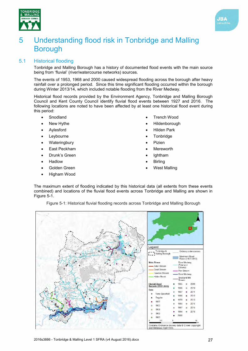
2016s3886 - Tonbridge & Malling Level 1 SFRA (v4 August 2016).docx 27
5 Understanding flood risk in Tonbridge and Malling Borough
5.1 Historical flooding Tonbridge and Malling Borough has a history of documented flood events with the main source being from ‘fluvial’ (river/watercourse networks) sources.
The events of 1953, 1968 and 2000 caused widespread flooding across the borough after heavy rainfall over a prolonged period. Since this time significant flooding occurred within the borough during Winter 2013/14, which included notable flooding from the River Medway.
Historical flood records provided by the Environment Agency, Tonbridge and Malling Borough Council and Kent County Council identify fluvial flood events between 1927 and 2016. The following locations are noted to have been affected by at least one historical flood event during this period:
Snodland New Hythe Aylesford Leybourne Wateringbury East Peckham Drunk’s Green Hadlow Golden Green Higham Wood
Trench Wood Hildenborough Hilden Park Tonbridge Pizien Mereworth Ightham Birling West Malling
The maximum extent of flooding indicated by this historical data (all extents from these events combined) and locations of the fluvial flood events across Tonbridge and Malling are shown in Figure 5-1.
Figure 5-1: Historical fluvial flooding records across Tonbridge and Malling Borough
2016s3886 - Tonbridge & Malling Level 1 SFRA (v4 August 2016).docx 28
Details of the significant flood events noted to affect Tonbridge and Malling are summarised as follows:
February 1953: a major storm surge, high tides and hurricane-force winds resulted in the failure of flood defences and severe flooding along the coast of England19. New Hythe and parts of Snodland were the areas noted to have been primarily affected by the flooding in the borough.
September 1968: prolonged heavy rainfall associated with a slow-moving depression and thunderstorms caused severe flooding across the south east of England. Between the 14th and 15th of September, 150mm-200mm of rainfall was recorded across Kent20 and caused the River Medway to exceed its channel capacity. This resulted in widespread flooding and damage in the borough between East Peckham and Tonbridge.
October 2000: the autumn of 2000 was the wettest on record and many river catchments were subjected to multiple flood events. Large areas of Kent and Sussex were left under water as rivers, including the River Medway, burst their banks21. Although this resulted in flooding between East Peckham and Tonbridge, the Leigh Barrier (constructed in 1981) is noted to have been instrumental in saving Tonbridge from severe flooding and damage.
December 2013: During the winter of 2013-14 a series of Atlantic depressions brought heavy rainfall and stormy conditions to much of England and Wales, including the River Medway catchment, where the largest flood of the period occurred on 23 December 2013. Flows seen in the Medway rivers were amongst the highest ever recorded, in several cases larger than the previous largest gauged event in 1968. Drivers for the notable events were the very wet antecedent conditions, combined with an intense storm on 23 December.
Historic flood records provided by a variety of data sources show a number of surface water flood incidents to have occurred across the borough. A large number of surface water flood incidents are noted to have occurred in the Tonbridge, Hildenborough, and West Malling areas. These areas are known to suffer from surface water flooding.
Other incidents of historical flood records provided by Tonbridge and Malling Borough Council are summarised as follows:
Regular groundwater flooding at Leigh Road, Hildenborough. Although the record does not specify property flooding, 17 gardens are recorded to be affected due to groundwater and an overflowing pond.
Groundwater flooding in 2001 at St, Leonards Street, West Malling. Records indicate approximately 3 properties were affected by the flooding due to an exceptionally high water table.
Sewer flooding in 2008 at Brook Street, Tonbridge. Although the record does not specify any property flooding, Brook Street and Haysden Lane were closed due to a blocked surface water sewer outfall.
5.1.1 Winter 2013-2014 flooding The most recent significant flood events to affect Tonbridge and Malling occurred in the winter of 2013-2014. The Kent Severe Weather Impacts Monitoring System (SWIMS) recorded five successive weather events across Kent and Medway:
The St Jude’s storm (28 October 2013) Fluvial event (1 November 2013) East coast tidal surge (5-6 December 2013) Fluvial and surface water floods (20 December 2013 – 28 March 2014) Groundwater floods (25 January 2014).
19 Remembering the floods of 1953: Devastation in North Kent (February 2013) 20 Tonbridge Weather Notes Post 1929 (1968: 14 & 15th September) 21 The Met Office: The Wet Autumn of 2000 (November 2012)

2016s3886 - Tonbridge & Malling Level 1 SFRA (v4 August 2016).docx 29
The SWIMS Event Summary Report for Kent & Medway states that Kent received 242% of the long-term average rainfall during the 2013-2014 winter. As part of the National Severe Weather Warning Service, 43 Yellow and 7 Amber weather warnings as well as 63 flood alerts were issued.
Of particular note is the storm of the 23-24 December 2013, which bought heavy rain (50-70mm) to southern England and caused significant widespread flooding22. Approximately 76mm of rain fell within 24 hours on the saturated Medway catchment, which caused the River Medway to rise significantly23.
The Leigh Flood Storage Area Review states that the December 2013 flows in the Medway rivers were amongst the highest ever recorded and exceeded those of the September 1968 event in several places. Although the Leigh Flood Storage Area (FSA) held back over 5.5 million cubic meters of water between the 24 and 27 of December, the discharge from the FSA led to severe flooding. Tonbridge, Hildenborough, East Peckham and the surrounding communities, as well as locations outside the borough, were the worst affected. The impacts from wider reports are summarised as follows:
335 residential properties and 101 commercial properties were flooded in Tonbridge and Malling24.
720 businesses are estimated to be indirectly affected (loss of utilities and access etc.) in Tonbridge and Malling25
Specifically, 102 homes (and 19 businesses) were flooded in Tonbridge, 157 homes were flooded in Hildenborough26 and 80 homes were flooded in Barden Road and Danvers Road in the Avebury Avenue area27.
Train services were suspended in Sevenoaks and Tonbridge following a landslide at Wadhurst28
Rest centres were opened in Tonbridge and Wateringbury with Kent County Council Family and Social Care staff on stand-by at all times to provide a 24-hour continuous response29.
5.2 Topography, geology, soils and hydrology Tonbridge and Malling Borough covers an area of approximately 85km2 and has a population of approximately 124,42630. There are 26 wards in the borough. The largest ward in the borough is Kings Hill with a population of approximately 7,77031. Other sizeable wards include Borough Green and Long Mill, Higham, Snodland West, West Malling and Leybourne, and Castle.
5.2.1 Topography The topography of the borough is displayed in Figure 5-2 and is primarily comprised of higher elevations and steeper slopes located in the centre and the north-west of the borough. The highest elevation reaches approximately 231 metres Above Ordnance Datum Newlyn (m AOD) near Fairseat and approximately 160m AOD in Hurst Wood between Govers Hill and Wrotham Heath. Elevations decrease in a north-east and southern direction towards Snodland and East Peckham respectively. In these regions, elevations are approximately 15m AOD. The main watercourse originating from the higher ground is the River Bourne, while the River Medway occupies the lower elevations in the borough.
22 The Met Office: Winter Storms, December 2013 to January 2014 (July, 2014) 23 The Environment Agency Press Release: New defence to reduce flood risk in Tonbridge (December, 2015) 24 Thanet District Council: Christmas & New Year 2013-2014 Storms & Floods Final Report (Appendix 1) 25 Thanet District Council: Christmas & New Year 2013-2014 Storms & Floods Final Report (Appendix 1) 26 Kent and Sussex Courier: Answers demanded by Tonbridge Flood Victims (January 2014) 27 The Environment Agency Press Release: New defence to reduce flood risk in Tonbridge (December, 2015) 28 SWIMS Event Summary Report for Kent & Medway Winter 2013-2014 Full Report 29 SWIMS Event Summary Report for Kent & Medway Winter 2013-2014 Full Report 30 Office for National Statistics, (June 2015), Annual Mid-Year Population Estimates: 2014 (MEY2 Population Estimates by single year of age and sex for local authorities in the UK, mid-2014). 31 Kent County Council Business Intelligence Statistical Bulletin (Page 16: 2001 to 2011 Census ward level population change for Tonbridge and Malling Borough Council) November 2012.
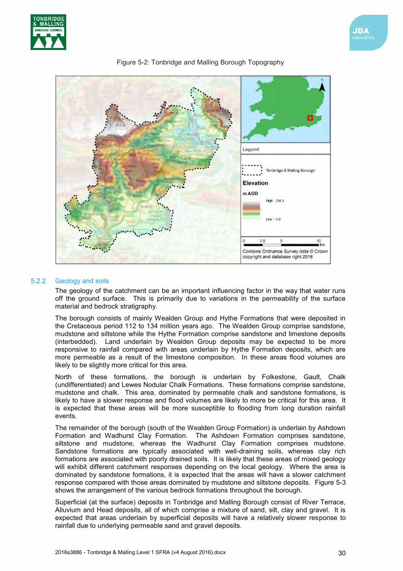
2016s3886 - Tonbridge & Malling Level 1 SFRA (v4 August 2016).docx 30
Figure 5-2: Tonbridge and Malling Borough Topography
5.2.2 Geology and soils The geology of the catchment can be an important influencing factor in the way that water runs off the ground surface. This is primarily due to variations in the permeability of the surface material and bedrock stratigraphy.
The borough consists of mainly Wealden Group and Hythe Formations that were deposited in the Cretaceous period 112 to 134 million years ago. The Wealden Group comprise sandstone, mudstone and siltstone while the Hythe Formation comprise sandstone and limestone deposits (interbedded). Land underlain by Wealden Group deposits may be expected to be more responsive to rainfall compared with areas underlain by Hythe Formation deposits, which are more permeable as a result of the limestone composition. In these areas flood volumes are likely to be slightly more critical for this area.
North of these formations, the borough is underlain by Folkestone, Gault, Chalk (undifferentiated) and Lewes Nodular Chalk Formations. These formations comprise sandstone, mudstone and chalk. This area, dominated by permeable chalk and sandstone formations, is likely to have a slower response and flood volumes are likely to more be critical for this area. It is expected that these areas will be more susceptible to flooding from long duration rainfall events.
The remainder of the borough (south of the Wealden Group Formation) is underlain by Ashdown Formation and Wadhurst Clay Formation. The Ashdown Formation comprises sandstone, siltstone and mudstone, whereas the Wadhurst Clay Formation comprises mudstone. Sandstone formations are typically associated with well-draining soils, whereas clay rich formations are associated with poorly drained soils. It is likely that these areas of mixed geology will exhibit different catchment responses depending on the local geology. Where the area is dominated by sandstone formations, it is expected that the areas will have a slower catchment response compared with those areas dominated by mudstone and siltstone deposits. Figure 5-3 shows the arrangement of the various bedrock formations throughout the borough.
Superficial (at the surface) deposits in Tonbridge and Malling Borough consist of River Terrace, Alluvium and Head deposits, all of which comprise a mixture of sand, silt, clay and gravel. It is expected that areas underlain by superficial deposits will have a relatively slower response to rainfall due to underlying permeable sand and gravel deposits.
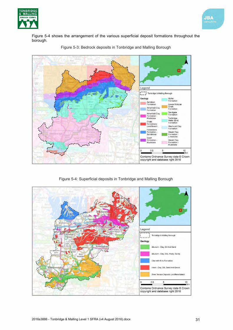
2016s3886 - Tonbridge & Malling Level 1 SFRA (v4 August 2016).docx 31
Figure 5-4 shows the arrangement of the various superficial deposit formations throughout the borough.
Figure 5-3: Bedrock deposits in Tonbridge and Malling Borough
Figure 5-4: Superficial deposits in Tonbridge and Malling Borough

2016s3886 - Tonbridge & Malling Level 1 SFRA (v4 August 2016).docx 32
Flooding in Tonbridge (24 December 2013)
5.3 Fluvial flood risk
5.3.1 Watercourses Watercourses flowing through Tonbridge and Malling Borough include:
The River Medway
Hilden Brook
Hawden Stream
Pen Stream
The River Bourne
Coult Stream
Alder Stream
Snodland Mill Stream.
Each of the watercourses listed above forms a tributary watercourse to the River Medway. Tributaries to these watercourses include primarily smaller Ordinary Watercourses and unnamed drains. A description of Main River watercourses is provided in Table 5-1.
The River Medway catchment (at Allington Lock: NGR 574850 158150) receives approximately 740mm of rain on average per year32. The adjoining catchments of the Hilden Brook (downstream extent: NGR 558900 146500) and the River Bourne (downstream extent: NGR 566350 147750) receive similar levels of average rainfall per year.
5.3.2 Flood risk The primary fluvial flood risk to Tonbridge and Malling Borough is associated with the River Medway. The main rivers in Tonbridge and Malling Borough are detailed in Table 5-1 and a figure of their location is provided in Appendix B.
In the borough, the River Medway is of fluvial influence in the south, and tidal/estuarine influence in the north. There is a long history of flooding from the River Medway. The town of Tonbridge has experienced severe flooding on several occasions from the River Medway, most recently in December 2013 when the river capacity was exceeded causing the town centre to flood. Flooding within the town centre (upstream of the weir) predominantly originates from Botany stream, which floods Avenue du Puy via the highway drainage before spreading to the Sainsbury’s car park33. The problem is exacerbated when the outfalls of drains into the rivers in Tonbridge are submerged, causing them to not freely discharge, resulting in ponding of low topographic areas such as the River Centre Industrial Estate and the area in and around Avebury Avenue34. Tonbridge also has fluvial flood risk from the Pen Stream, Hilden Brook and Hawden Stream.
Other fluvial flood risk areas identified in the borough are from the main rivers of River Bourne and Hawden Stream. Hawden Stream was last recorded to have flooded in December 2013 and caused extensive flooding of Hilden Park, although the main driver for this flooding was elevated water levels on the River Medway propagating upstream. In addition to parts of the River Bourne flooding in December 2013 due to elevated River Medway levels, flood flows along the
32 FEH CD-ROM v3.0 © NERC (CEH). © Crown copyright. © AA. (2009) 33 Kent County Council: Flood Risk to Communities – Tonbridge and Malling (2016) 34 Kent County Council: Flood Risk to Communities – Tonbridge and Malling (2016)
2016s3886 - Tonbridge & Malling Level 1 SFRA (v4 August 2016).docx 33
watercourse itself contributed to flooding. The watercourse has also been reported to have flooded significantly in 1958 when the drains were over-capacity after heavy rainfall and during Autumn 2000, which saw widespread flooding in the south east. During this period nearly 40 properties were reported to have flooded on the River Bourne and neighbouring Coult Stream35.
Ordinary watercourses that have flooded previously in the borough have affected the areas of Wateringbury, Pizien Well and Mereworth36. The incidents have occurred due to insufficient maintenance, due to the riparian owners not being aware of their duty to maintain the watercourse37. Another cause of Ordinary Watercourse flooding has occurred historically from where flows have exceeded the channel capacity. This has caused Birling and West Malling to have previously flooded38. The Busty Ordinary Watercourse has also been cited to regularly flood in Ightham due to obstruction to the watercourse channel causing the flow to exceed the channel39.
In addition to flood risk shown by the flood risk mapping, there are a number of small watercourses and field drains which may pose a risk to development. Generalised Flood Zone mapping (where more detailed modelling investigations are not available) is only available for watercourses with a catchment greater than 3km2. Therefore, whilst these smaller watercourses may not be shown as having flood risk on the flood risk mapping, it does not necessarily mean that there is no flood risk. As part of a site-specific flood risk assessment it will be necessary to assess the risk from these smaller watercourses where these may influence the site.
Given the widespread flooding recorded historically within the borough (particularly along the River Medway floodplain as evidenced in Figure 5-1) particular areas (e.g. roads, settlements) of the borough susceptible to fluvial flooding have not been listed here. It should be noted that defences are present within the borough, particularly upstream of, and within Tonbridge, and downstream of Maidstone which act to reduce flooding. This may be particularly important when considering the functional floodplain (Flood Zone 3b) for development proposals. Further details on defences in Tonbridge and Malling is presented in section 6.
The delineation of the fluvial Flood Zones and the areas of Tonbridge and Malling Borough which are within fluvial Zones are shown in Map 1 in Appendix C. Consideration of how climate change may influence the predicted Flood Zones in the future is indicated within mapping of Appendix D.
An important consideration when assessing fluvial flood risk is the probability of a failure of river defence occurring or being exceeded. Risk of defence failure is reduced by the actions of the defence owners in maintaining the defences, but there remains a residual risk of breach of exceedance. The necessity for assessment of the ‘residual’ risk of defence failure (e.g. breach) should be considered on a site by site basis. This requirement also applies to tidal flood risk within the borough (section 5.4). Information on defences within the borough is provided in section 6.
35 River Bourne and Coult Stream Flood Modelling and Mapping Study, Environment Agency, August 2011. 36 Kent County Council: Tonbridge and Malling Stage 1 Surface Water Management Plan (2013) 37 Environment Agency: "Living on the Edge" report 38 Kent County Council: Tonbridge and Malling Stage 1 Surface Water Management Plan (2013) 39 Kent County Council: Tonbridge and Malling Stage 1 Surface Water Management Plan (2013)
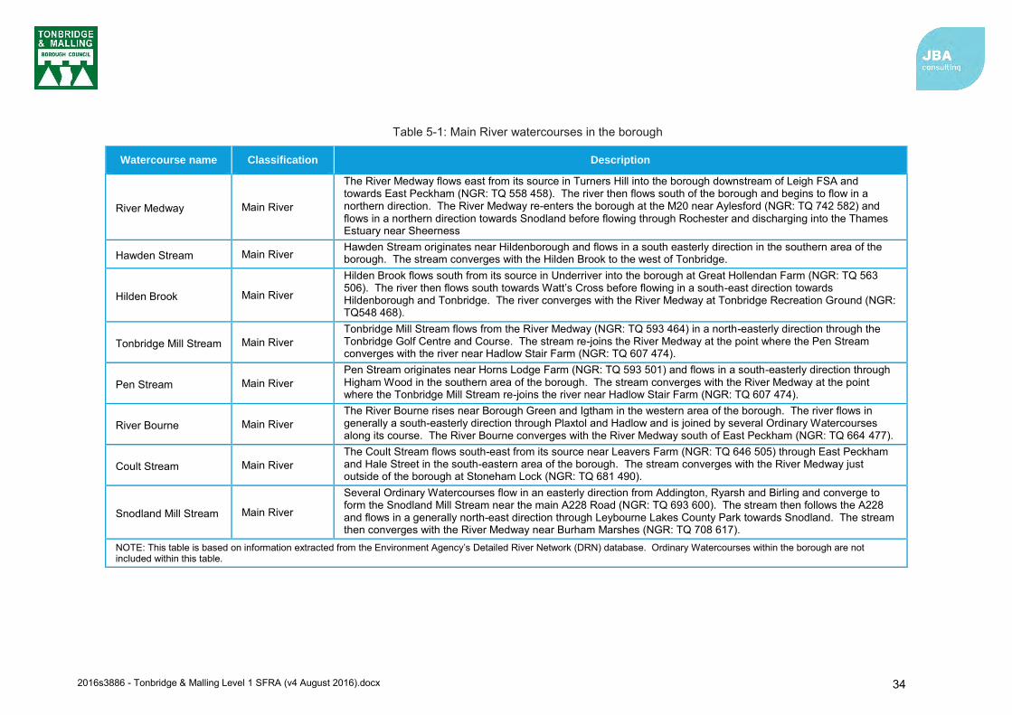
2016s3886 - Tonbridge & Malling Level 1 SFRA (v4 August 2016).docx 34
Table 5-1: Main River watercourses in the borough
Watercourse name Classification Description
River Medway Main River
The River Medway flows east from its source in Turners Hill into the borough downstream of Leigh FSA and towards East Peckham (NGR: TQ 558 458). The river then flows south of the borough and begins to flow in a northern direction. The River Medway re-enters the borough at the M20 near Aylesford (NGR: TQ 742 582) and flows in a northern direction towards Snodland before flowing through Rochester and discharging into the Thames Estuary near Sheerness
Hawden Stream Main River Hawden Stream originates near Hildenborough and flows in a south easterly direction in the southern area of the borough. The stream converges with the Hilden Brook to the west of Tonbridge.
Hilden Brook Main River
Hilden Brook flows south from its source in Underriver into the borough at Great Hollendan Farm (NGR: TQ 563 506). The river then flows south towards Watt’s Cross before flowing in a south-east direction towards Hildenborough and Tonbridge. The river converges with the River Medway at Tonbridge Recreation Ground (NGR: TQ548 468).
Tonbridge Mill Stream Main River Tonbridge Mill Stream flows from the River Medway (NGR: TQ 593 464) in a north-easterly direction through the Tonbridge Golf Centre and Course. The stream re-joins the River Medway at the point where the Pen Stream converges with the river near Hadlow Stair Farm (NGR: TQ 607 474).
Pen Stream Main River Pen Stream originates near Horns Lodge Farm (NGR: TQ 593 501) and flows in a south-easterly direction through Higham Wood in the southern area of the borough. The stream converges with the River Medway at the point where the Tonbridge Mill Stream re-joins the river near Hadlow Stair Farm (NGR: TQ 607 474).
River Bourne Main River The River Bourne rises near Borough Green and Igtham in the western area of the borough. The river flows in generally a south-easterly direction through Plaxtol and Hadlow and is joined by several Ordinary Watercourses along its course. The River Bourne converges with the River Medway south of East Peckham (NGR: TQ 664 477).
Coult Stream Main River The Coult Stream flows south-east from its source near Leavers Farm (NGR: TQ 646 505) through East Peckham and Hale Street in the south-eastern area of the borough. The stream converges with the River Medway just outside of the borough at Stoneham Lock (NGR: TQ 681 490).
Snodland Mill Stream Main River
Several Ordinary Watercourses flow in an easterly direction from Addington, Ryarsh and Birling and converge to form the Snodland Mill Stream near the main A228 Road (NGR: TQ 693 600). The stream then follows the A228 and flows in a generally north-east direction through Leybourne Lakes County Park towards Snodland. The stream then converges with the River Medway near Burham Marshes (NGR: TQ 708 617).
NOTE: This table is based on information extracted from the Environment Agency’s Detailed River Network (DRN) database. Ordinary Watercourses within the borough are not included within this table.
2016s3886 - Tonbridge & Malling Level 1 SFRA (v4 August 2016).docx 35
5.4 Tidal flood risk Tidal flood risk is assessed based on Extreme Still Water Sea Levels (ESWSL). An ESWSL is the level the sea is expected to reach during a storm event for a particular magnitude of flood event as a result of the combination of tides and surges. As these levels are based on ‘still’ water, the effect of short-term fluctuations in sea level associated with wind and swell waves are not included.
The tidal influence of the River Medway extends from the far north of the borough to beyond Allington, located at the border of the borough. Aylesford and Snodland have previously been flooded from overtopping of defences that line the river. The most significant event recorded occurred in 1953, evidenced by interrogation of the Environment Agency’s recorded flood outline dataset40,41. However, the improvements to coastal and tidal defences that have taken place following the flooding on 1953 should be kept in mind when viewing the data for this event.
Tidal flooding is caused by extreme tide levels exceeding ground and/or defence levels. Flood Zones 1, 2 and 3 delineate areas at low risk, medium risk and high risk respectively from both tidal and fluvial flooding. Flood Zones do not take into account the effects of flood defences, and as such provides a worst-case assessment of flood risk. The delineation of the tidal Flood Zones and the areas of Tonbridge and Malling Borough which are within tidal Zones are shown in Map 2 in Appendix C. Consideration of how climate change may influence the predicted Flood Zones in the future is indicated within mapping of Appendix D.
Flood Zones 2 and 3 represent the area that would be flooded in the 0.5% Annual Exceedance Probability (AEP) and 0.1% AEP tidal events, respectively, in the absence of defences. There is little difference in Flood Zone 2, 3a and 3b in the area of tidal influence within the borough due to the low lying land adjacent to the channel.
5.5 Surface water flooding Flooding from surface water runoff (or ‘pluvial’ flooding) is usually caused by intense rainfall that may only last a few hours. Flooding usually occurs when rainfall fails to infiltrate to the ground or enter the drainage system. Ponding generally occurs at low points in the topography. The likelihood of flooding is dependent on not only the rate of runoff but also saturation of the receiving soils, the groundwater levels and the condition of the surface water drainage system (i.e. surface water sewers, highway authority drains and gullies, open channels, Ordinary Watercourses and SuDS). Surface water flooding problems are inextricably linked to issues of poor drainage, or drainage blockage by debris, and sewer flooding.
The updated Flood Map for Surface Water (uFMfSW) predominantly follows topographical flow paths of existing watercourses or dry valleys with some isolated ponding located in low lying areas. Mapping of the uFMfSW throughout the borough is provided in Appendix E.
Surface water food records provided by a variety of data sources are shown in Figure 5-5. Based on the data provided, there are at least 106 records of surface water flooding across the borough since 2000. The majority of surface water flood records are clustered in the southern most section of the borough, in the vicinity of Tonbridge and Hildenborough. Several surface water flood records are also located in the northern area of the borough surrounding West Malling.
40 Medway Strategic Flood Risk Assessment: A Guide 41 Environment Agency Historic Flood Map
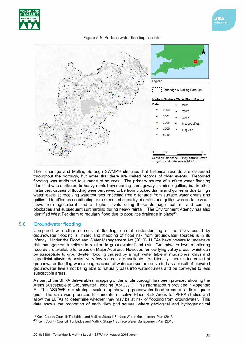
2016s3886 - Tonbridge & Malling Level 1 SFRA (v4 August 2016).docx 36
Figure 5-5: Surface water flooding records
The Tonbridge and Malling Borough SWMP42 identifies that historical records are dispersed throughout the borough, but notes that there are limited records of older events. Recorded flooding was attributed to a range of sources. The primary source of surface water flooding identified was attributed to heavy rainfall overloading carriageways, drains / gullies, but in other instances, causes of flooding were perceived to be from blocked drains and gullies or due to high water levels at receiving watercourses impeding free discharge from surface water drains and gullies. Identified as contributing to the reduced capacity of drains and gullies was surface water flows from agricultural land at higher levels silting these drainage features and causing blockages and subsequent surcharging during heavy rainfall. The Environment Agency has also identified West Peckham to regularly flood due to poor/little drainage in place43.
5.6 Groundwater flooding Compared with other sources of flooding, current understanding of the risks posed by groundwater flooding is limited and mapping of flood risk from groundwater sources is in its infancy. Under the Flood and Water Management Act (2010), LLFAs have powers to undertake risk management functions in relation to groundwater flood risk. Groundwater level monitoring records are available for areas on Major Aquifers. However, for low lying valley areas, which can be susceptible to groundwater flooding caused by a high water table in mudstones, clays and superficial alluvial deposits, very few records are available. Additionally, there is increased of groundwater flooding where long reaches of watercourses are culverted as a result of elevated groundwater levels not being able to naturally pass into watercourses and be conveyed to less susceptible areas.
As part of the SFRA deliverables, mapping of the whole borough has been provided showing the Areas Susceptible to Groundwater Flooding (AStGWF). This information is provided in Appendix F. The AStGWF is a strategic-scale map showing groundwater flood areas on a 1km square grid. The data was produced to annotate indicative Flood Risk Areas for PFRA studies and allow the LLFAs to determine whether they may be at risk of flooding from groundwater. This data shows the proportion of each 1km grid square, where geological and hydrogeological
42 Kent County Council: Tonbridge and Malling Stage 1 Surface Water Management Plan (2013) 43 Kent County Council: Tonbridge and Malling Stage 1 Surface Water Management Plan (2013)

2016s3886 - Tonbridge & Malling Level 1 SFRA (v4 August 2016).docx 37
conditions indicate that groundwater might emerge. It does not show the likelihood of groundwater flooding occurring, nor does it take account of the chance of flooding from groundwater rebound. This dataset covers a large area of land and only isolated locations within the overall susceptible area are actually likely to suffer the consequences of groundwater flooding. The information indicates that susceptibility to groundwater flooding is greatest at the north of the borough, focused on the areas of Birling, New Hythe, Leybourne and Snodland, where >50% of area within the 1km grid squares are considered to be susceptible to groundwater flooding. This strongly links with the bedrock deposits displayed in Figure 5-3. Tonbridge town centre and the River Medway corridor downstream of here also indicate susceptibility >50%, with the alluvial deposits in this area being a contributing factor. Elsewhere within the borough susceptibility to groundwater flooding is typically <25% within a given 1km grid square, or no information is presented at all.
The AStGWF data should be used only in combination with other information, for example local or historical data. It should not be used as sole evidence for any specific flood risk management, land use planning or other decisions at any scale. However, the data can help to identify areas for assessment at a local scale where finer resolution datasets exist. It should be noted that although an area may be designated as susceptible to groundwater flooding, this does not mean that groundwater flooding will definitely be a problem within these areas, rather it provides an indication of the risk.
The Tonbridge and Malling SWMP identified two recorded events of groundwater flooding in the borough. In 2001 three properties were reported to have been flooded on St. Leonards Street in West Malling. It was observed that there was an exceptionally high water table during this event. The other area known to flood regularly is the residential curtilage of Leigh Road in Hildenborough. Reports suggest that at least 17 gardens were affected from this source of flooding. This event may have been caused by a burst underground pipe rather than flooding from hard rock aquifers or superficial deposits, as the direct source was not determined.
Developers planning to build within groundwater emergence zones should still investigate whether groundwater flooding is likely to be a problem locally.
5.7 Flooding from artificial sources
5.7.1 Flooding from sewers Sewer flooding occurs when intense rainfall overloads the sewer system capacity (surface water, foul or combined), and/or when sewers cannot discharge freely into watercourses due to high water levels. Sewer flooding can also be caused when problems such as blockages, collapses or equipment failure occur in the sewerage system. Infiltration, entry of soil or groundwater into sewer systems via faults within the fabric of the sewerage system, is another cause of sewer flooding. Infiltration is often related to shallow groundwater, and may cause high flows for prolonged periods of time. The Tonbridge and Malling SWMP44 identifies that information supplied by Southern Water resulted predominantly from the hydraulic overload of sewers or an overloaded pumping station, with a number of sewer flood incidents recorded in Tonbridge Town and in Hildenborough.
Since 1980, the Sewers for Adoption45 guidelines have meant that most new surface water sewers have been designed to have capacity for a rainfall event with a 1 in 30 chance of occurring in any given year, although until recently this did not apply to smaller private systems. This means that even where sewers are built to current specification, they are likely to be overwhelmed by larger events of the magnitude often considered when looking at river or surface water flooding (e.g. a 1 in 100 chance of occurring in any given year). Existing sewers can also become overloaded as new development adds to their catchment, or due to incremental increases in roofed and paved surfaces at the individual property scale (urban creep). Sewer flooding is therefore a problem that could occur in many locations across the borough.
Historical incidents of flooding are detailed by Southern Water in their DG5 register. This database records incidents of flooding relating to public foul, combined or surface water sewers and displays which properties suffered flooding. For confidentiality reasons, this data has been supplied on a postcode basis from the Sewer Incident Report Form (SIRF) hydraulic overload
44 Kent County Council: Tonbridge and Malling Stage 1 Surface Water Management Plan (2013) 45 Sewers for Adoption 7th Edition - A Design & Construction Guide for Developer. WRc plc. September 2012.
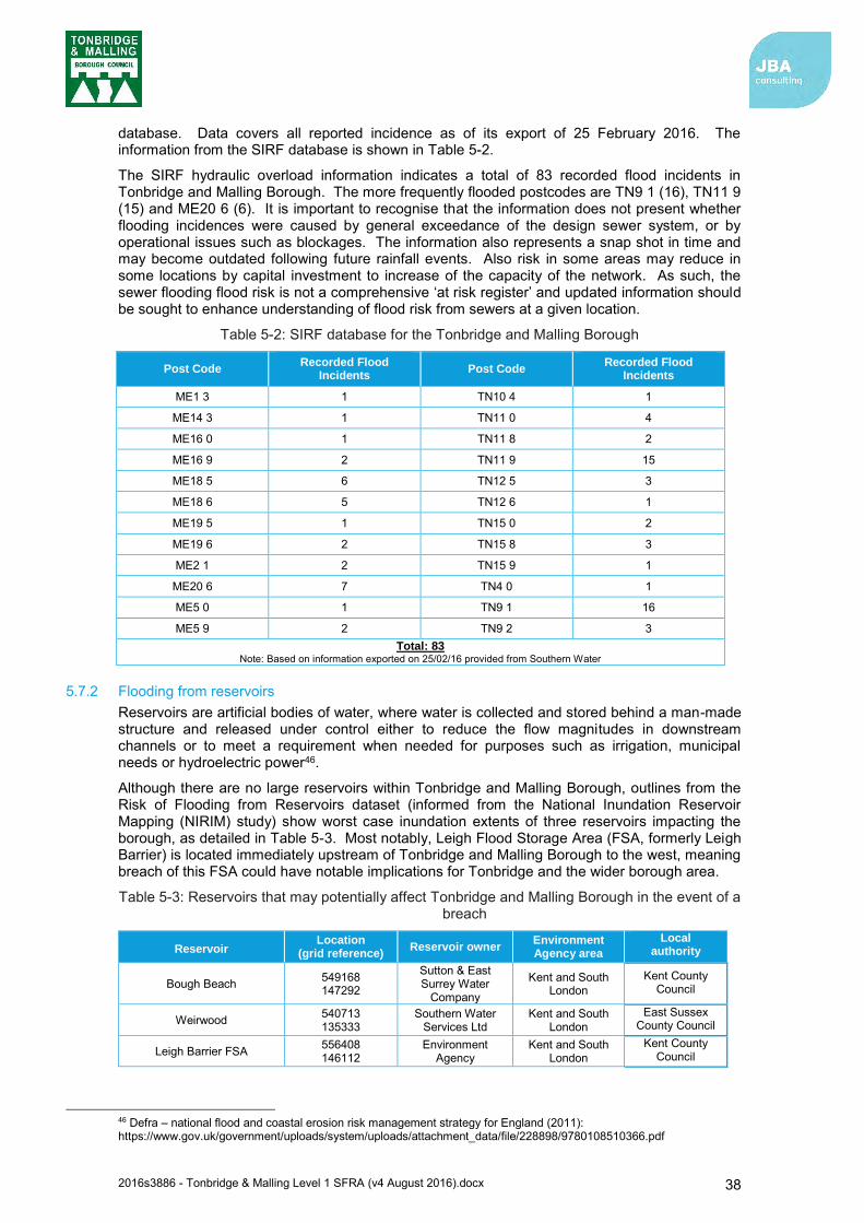
2016s3886 - Tonbridge & Malling Level 1 SFRA (v4 August 2016).docx 38
database. Data covers all reported incidence as of its export of 25 February 2016. The information from the SIRF database is shown in Table 5-2.
The SIRF hydraulic overload information indicates a total of 83 recorded flood incidents in Tonbridge and Malling Borough. The more frequently flooded postcodes are TN9 1 (16), TN11 9 (15) and ME20 6 (6). It is important to recognise that the information does not present whether flooding incidences were caused by general exceedance of the design sewer system, or by operational issues such as blockages. The information also represents a snap shot in time and may become outdated following future rainfall events. Also risk in some areas may reduce in some locations by capital investment to increase of the capacity of the network. As such, the sewer flooding flood risk is not a comprehensive ‘at risk register’ and updated information should be sought to enhance understanding of flood risk from sewers at a given location.
Table 5-2: SIRF database for the Tonbridge and Malling Borough
Post Code Recorded Flood
Incidents Post Code
Recorded Flood Incidents
ME1 3 1 TN10 4 1
ME14 3 1 TN11 0 4
ME16 0 1 TN11 8 2
ME16 9 2 TN11 9 15
ME18 5 6 TN12 5 3
ME18 6 5 TN12 6 1
ME19 5 1 TN15 0 2
ME19 6 2 TN15 8 3
ME2 1 2 TN15 9 1
ME20 6 7 TN4 0 1
ME5 0 1 TN9 1 16
ME5 9 2 TN9 2 3 Total: 83
Note: Based on information exported on 25/02/16 provided from Southern Water
5.7.2 Flooding from reservoirs Reservoirs are artificial bodies of water, where water is collected and stored behind a man-made structure and released under control either to reduce the flow magnitudes in downstream channels or to meet a requirement when needed for purposes such as irrigation, municipal needs or hydroelectric power46.
Although there are no large reservoirs within Tonbridge and Malling Borough, outlines from the Risk of Flooding from Reservoirs dataset (informed from the National Inundation Reservoir Mapping (NIRIM) study) show worst case inundation extents of three reservoirs impacting the borough, as detailed in Table 5-3. Most notably, Leigh Flood Storage Area (FSA, formerly Leigh Barrier) is located immediately upstream of Tonbridge and Malling Borough to the west, meaning breach of this FSA could have notable implications for Tonbridge and the wider borough area.
Table 5-3: Reservoirs that may potentially affect Tonbridge and Malling Borough in the event of a breach
Reservoir Location
(grid reference) Reservoir owner
Environment Agency area
Local authority
Bough Beach 549168 147292
Sutton & East Surrey Water
Company
Kent and South London
Kent County Council
Weirwood 540713 135333
Southern Water Services Ltd
Kent and South London
East Sussex County Council
Leigh Barrier FSA 556408 146112
Environment Agency
Kent and South London
Kent County Council
46 Defra – national flood and coastal erosion risk management strategy for England (2011): https://www.gov.uk/government/uploads/system/uploads/attachment_data/file/228898/9780108510366.pdf
2016s3886 - Tonbridge & Malling Level 1 SFRA (v4 August 2016).docx 39
Reservoir flooding is very different from other forms of flooding. It may happen with little or no warning and evacuation will need to happen immediately. The likelihood of such flooding is very difficult to estimate, but it is less likely than flooding from rivers or surface water. It may not be possible to seek refuge from floodwaters upstairs as buildings could be unsafe or unstable due to the force of water from the reservoir breach or failure. The Environment Agency maps (available online at the Environment Agency ‘What’s in Your Backyard’ site47 represent a credible worst case scenario. In these circumstances it is the time to inundation, the depth of inundation and the velocity of flood flows that will be most influential.
The risk to development for reservoirs is residual but developers should consider reservoir flooding during the planning stage.
Developers should seek to contact the reservoir owner to obtain information which may include:
o Reservoir characteristics: type, dam height at outlet, area / volume, outflow location
o Operation: discharge rates / maximum discharge
o Discharge during emergency drawdown
o Inspection / maintenance regime
Developers should apply the sequential approach to locating development within the site. The following questions should be considered:
o Can risk be avoided through substituting less vulnerable uses or by amending the site layout?
o Can it be demonstrated that less vulnerable uses for the site have been considered and reasonably discounted?
o Can layout be varied to reduce the number of people or flood risk vulnerability or building units located in higher risk parts of the site?
Developers should consult with relevant authorities regarding emergency plans in case of reservoir breach.
5.8 The impact of climate change Flood Risk Assessments (FRAs) are required to demonstrate future implications of climate change have been considered, and risks managed where possible, for the lifetime of the proposed development. This may include for instance:
Consideration of the vulnerability of the proposed development types or land use allocations to flooding and directing the more vulnerable away from areas at higher risk due to climate change.
Use of ‘built in’ resilience measures. For example, raised floor levels.
Capacity or space in the development to include additional resilience measures in the future, using a ‘managed adaptive’ approach.
This latter point acknowledges that there may be instances where some flood risk management measures are not necessary needed now but may be in the future. This ‘managed adaptive’ approach may include for example setting a development away from a river so it is easier to improve flood defences in the future.
47 http://apps.environment-agency.gov.uk/wiyby/default.aspx

2016s3886 - Tonbridge & Malling Level 1 SFRA (v4 August 2016).docx 40
The latest guidance on climate change allowances for flood risk assessment released by the Environment Agency48provide predictions of anticipated change for
peak river flow;
peak rainfall intensity;
sea level rise; and
offshore wind speed and extreme wave height.
Given the timing of the release of this climate change flood risk mapping information, this SFRA does not reflect this updated guidance. The mapping presented therefore reflects the previous requirements for FRAs as set out in the now out of date Environment Agency guidance Climate change allowances for planners: Guidance to support the National Planning Policy Framework September 201349. This information presented within the Level 1 SFRA can be used as a guide, but an expectation of any applications for development is that the latest guidance is used to provide evidence for how climate change impacts will be managed at a given site.
5.8.1 Fluvial flooding Climate change mapping has been provided in Appendix C (refer to the comment in section 5.8 regarding the latest climate change allowance guidance) as well as the site-specific summary tables provided in Appendix A.
It is important to note that climate change does not just affect the extent of flooding. Even where flood extents do not significantly change; flooding is likely to become more frequent under a climate change scenario. The impact of an event with a given probability is also likely to become more severe. For example, as water depths, velocities and flood hazard increase, so will the risk to people and property. Although qualitative statements can be made as to whether extreme events are likely to increase or decrease over the UK in the future, there is still considerable uncertainty regarding the magnitude of localised impact of these changes. Further details regarding the uncertainties in predicting the impacts of climate change can be found in:
Environment Agency (2016) Flood Risk Assessments: Climate Change Allowances
UK Climate Projections (UKCP09)
5.8.2 Tidal flooding Climate change is predicted to influence the rate of sea level rise, in addition to offshore wind speed and extreme wave height. For Tonbridge and Malling Borough, the influence of offshore wind speed and extreme wave height on predicted flooding is likely to be negligible given the tidal Medway is some way inland. However, sea level rise will influence the tidal levels which propagate upstream along the Medway, thereby impacting flood risk. Guidance on required net sea level rise allowances (after adjustment for land movement changes) is presented within the updated guidance released by the Environment Agency. The adjustments to the allowances from previous guidance are less marked. However, the information presented within this Level 1 SFRA remains as per the previous guidance and it is expected that development applications use the updated guidance to inform their assessment of flood risk.
5.8.3 Surface Water flooding Climate change is predicted to increase rainfall intensity in the future by up to 40%50 under the new range of allowances published by the Environment Agency. This will increase the likelihood and frequency of surface water flooding, particularly in impermeable urban areas, and areas that are already susceptible. Changes to predicted rainfall should be incorporated into flood risk assessments and drainage and surface water attenuation schemes associated with developments.
48 https://www.gov.uk/guidance/flood-risk-assessments-climate-change-allowances 49 https://www.gov.uk/government/uploads/system/uploads/attachment_data/file/501841/LIT_8496_5306da.pdf 50 https://www.gov.uk/guidance/flood-risk-assessments-climate-change-allowances
2016s3886 - Tonbridge & Malling Level 1 SFRA (v4 August 2016).docx 41
5.8.4 Groundwater flooding The effect of climate change on groundwater flooding problems, and those watercourses where groundwater has a large influence on winter flood flows, is more uncertain. The updated climate change guidance released February 2016 does not provide information on expected changes to groundwater flooding under future climate change. However, milder wetter winters may increase the frequency of groundwater flooding incidents in areas that are already susceptible, but warmer drier summers could counteract this effect by drawing down groundwater levels to a greater extent during the summer months. Where groundwater flooding is expected to influence a development site, it will be expected that consideration of groundwater flooding under a changing climate is assessed and measures taken to mitigate any change in risk.
5.8.5 Climate change assessment of flood risk at sites To inform the SFRA, outputs from hydraulic modelling and mapping of fluvial flood risk from the River Medway (excluding the majority of its tributaries except for the River Teise and River Beult) expected under climate change was used. This information was prepared by the Environment Agency and permitted for use in the SFRA. The modelling and mapping completed focused on predicted flood risk at the 2080s epoch (2070-2115) under increased flow rates of +35% and +70% for the undefended case 1% AEP event (Flood Zone 3a). The fluvial flow allowances represent the High Central and Upper End allowances under the latest guidance. Tidal/coastal flood risk mapping is also available for River Medway in the 0.5% AEP event (Flood Zone 3a) accounting for net sea level rise to the year 2115. This information was used alongside each of the fluvial flood risk mapping files to inform flood risk under the climate change scenarios.
Flood Zone mapping following the latest climate change guidance is not available for non-Medway watercourses (except for the River Teise and River Beult which was also prepared by the Environment Agency). Consideration of development outside the Medway floodplain should seek to confirm whether the site(s) would be influenced by flood risk from other watercourses both in the present day and with anticipated changes in flows brought about by climate change.
With respect to the vulnerability classification of development and its intended lifetime, the Environment Agency consider that within Flood Zone 3a More Vulnerable development types should consider the Higher Central (+35% flows) estimate as the design flood, whilst Essential Infrastructure should consider the Upper End (+70% flows) estimate. Less Vulnerable and Water Compatible development should consider the Central (+25% flows) estimate as the design flood, which is not available from the current flood risk information.

2016s3886 - Tonbridge & Malling Level 1 SFRA (v4 August 2016).docx 42
6 Flood defences A high-level review of formal flood defences was carried out for this SFRA interrogating existing information indicating their condition and standard of protection. Details of the flood defence locations and condition were provided by the Environment Agency for the purpose of preparing this assessment, in addition to some explanation of some of these defences. Defences are categorised as either raised flood defences (e.g. walls/embankments) or flood storage areas (FSAs). The assessment has considered man-made defences and not natural defences which may arise for instance due to the presence of naturally high ground adjacent to a settlement.
These types of defences and their location is summarised in the sections below.
6.1 Defence standard of protection and residual risk One of the principal aims of the SFRA is to outline the present risk of flooding across Tonbridge and Malling Borough including consideration of the effect of flood risk management measures (including flood banks and defences). The modelling that informs understanding of flood risk within the borough is typically of a catchment-wide nature, suitable for preparing evidence on possible site options for development. In cases where a specific site risk assessment is required, detailed studies should seek to refine the current understanding of flood risk from all sources.
Consideration of the residual risk behind flood defences has been undertaken as part of this study. The residual risk of flooding in a flood event or from failure of defences should also be carefully considered. Developers should also consider the standard of protection provided by defences and residual risk as part of a detailed Flood Risk Assessment (FRA).
6.2 Defence condition Formal structural defences are given a rating based on a grading system for their condition51. A summary of the grading system used by the Environment Agency for condition is provided in Table 6-1. This detail, in addition to descriptions and standard of protection for each, were provided by the Environment Agency for the purpose of preparing this SFRA which reports on the standard of protection using this information.
Table 6-1: Defence asset condition rating
Grade Rating Description
1 Very Good Cosmetic defects that will have no effect on performance.
2 Good Minor defects that will not reduce the overall performance of the asset.
3 Fair Defects that could reduce the performance of the asset.
4 Poor Defects that would significantly reduce the performance of the asset. Further investigation required.
5 Very Poor Severe defects resulting in complete performance failure.
Source: Condition Assessment Manual – Environment Agency 2006
The condition of existing flood defences and whether they will continue to be maintained and/or improved in the future requires consideration as part of the risk based sequential approach and, in light of this, whether possible site options for development are appropriate and sustainable. In addition, detailed FRAs will need to thoroughly explore the condition of defences, especially where these defences are informal and demonstrate a wide variation of condition grades. It is important that all of these assets are maintained to a good condition and their function remains unimpaired.
A review of key defences across Tonbridge and Malling Borough, their condition and standard of protection is included in the following sections.
51 Condition Assessment Manual, Environment Agency (2006)

2016s3886 - Tonbridge & Malling Level 1 SFRA (v4 August 2016).docx 43
6.3 Defences in Tonbridge and Malling Borough
6.3.1 Raised defences
Tonbridge Within Tonbridge, raised flood defences are present alongside sections of channel or set back from the channel to protect certain areas from river flooding. The location of these, and the authority which maintains them, is displayed in Figure 6-1. Raised walls are present along large parts of the River Medway channel notably adjacent to Avebury Avenue, Buleys Weir to Wharf Road and Tonbridge Town Walls and Town Lock defences between Wharf Road and Town Lock. At each of the locations noted above, the defences have recently (2014-2016) been re-furbished or reconstructed meaning the condition grade is ‘Very Good’ (Figure 6-2).
The flood defence wall along the right bank of the Medway restricts flood water entering the town of Tonbridge during periods of significant flow within the river. However, water can approach the top of this defence along the Medway in Wharf Road in severe events, leading to the possibility of the walls being overtopped by waves52.
The Standard of protection afforded by these defences is variable (Figure 6-3). Of note is that the standard of protection for the new defence at Avebury Avenue is not recorded in the data provided as this defence was constructed in early 2016. Standard of protection is expected to be defined when updated flood risk modelling is completed within Tonbridge. If this defence is critical to a development or area of land, advice should be sought from the Environment Agency regarding the protection it provides.
Figure 6-1: Location of defences within Tonbridge
Note: within the flood risk modelling completed to inform Flood Zones and other flood risk outputs within Tonbridge, only defences between Buleys Weir and Tonbridge Town Lock (right bank of the River Medway) were implemented for the defended case and removed for the undefended case.
52 Kent County Council: Flood Risk to Communities – Tonbridge and Malling (March 2016)

2016s3886 - Tonbridge & Malling Level 1 SFRA (v4 August 2016).docx 44
Figure 6-2: Condition grade of defences within Tonbridge
Figure 6-3: Design Standard of Protection for defences within Tonbridge
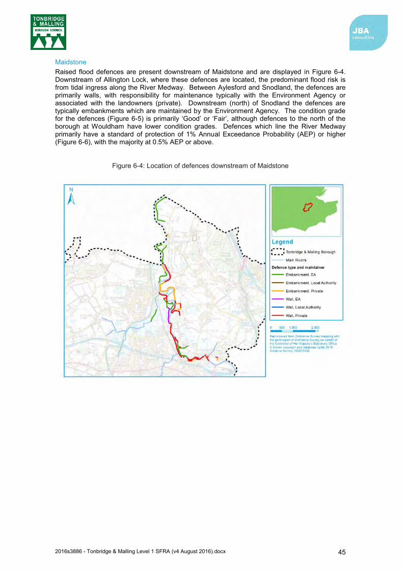
2016s3886 - Tonbridge & Malling Level 1 SFRA (v4 August 2016).docx 45
Maidstone Raised flood defences are present downstream of Maidstone and are displayed in Figure 6-4. Downstream of Allington Lock, where these defences are located, the predominant flood risk is from tidal ingress along the River Medway. Between Aylesford and Snodland, the defences are primarily walls, with responsibility for maintenance typically with the Environment Agency or associated with the landowners (private). Downstream (north) of Snodland the defences are typically embankments which are maintained by the Environment Agency. The condition grade for the defences (Figure 6-5) is primarily ‘Good’ or ‘Fair’, although defences to the north of the borough at Wouldham have lower condition grades. Defences which line the River Medway primarily have a standard of protection of 1% Annual Exceedance Probability (AEP) or higher (Figure 6-6), with the majority at 0.5% AEP or above.
Figure 6-4: Location of defences downstream of Maidstone

2016s3886 - Tonbridge & Malling Level 1 SFRA (v4 August 2016).docx 46
Figure 6-5: Condition grade of defences downstream of Maidstone
Figure 6-6: Design Standard of Protection for defences downstream of Maidstone

2016s3886 - Tonbridge & Malling Level 1 SFRA (v4 August 2016).docx 47
6.3.2 Flood storage areas Two flood storage areas are present within the borough, Leigh FSA and East Peckham FSA (locations displayed in Figure 6-7).
Figure 6-7: Location of Leigh and East Peckham FSAs
Leigh Flood Storage Area Leigh FSA is an online storage reservoir located on the River Medway 2-3km upstream of Tonbridge and was constructed in 1982. The FSA is kept empty under normal flow conditions, but during times of raised flows attenuates floods from the Upper Medway catchment (River Medway and River Eden) and aims to reduce the flow passing downstream through Tonbridge and beyond. The FSA consists of an impounding embankment with an outflow through three radial gates. It is operated to limit forward flows but has a maximum impounding level of 28.05metres Above Ordnance Datum Newlyn (m AOD). If that level is likely to be exceeded, then alternative operation of the FSA is considered by the Environment Agency.
Assigning a single standard of protection for the FSA is not possible as the inflows to the FSA, volume of water stored and reduced outflows possible, leading to reductions in flooding varies on an event by event basis. The FSA has been regulated under the Reservoirs Act 1975 (now under the Flood and Water Management Act 2010) and has a condition grade of 1 (Very Good).
The Kent County Council Flood Risk to Communities – Tonbridge and Malling (March 2016) report has stated that prior to the floods that occurred over the winter of 2013/2014, the Leigh FSA was planned to have work carried out by the Environment Agency to extend the life to 203553. Since the event a partnership has formed between the EA, KCCC and TMBC to bring forward plans to increase the capacity of the Leigh FSA. It is anticipated that preliminary works are to commence in 2018, with the aim to complete the main construction by 2022. The planned works will be a direct benefit to Tonbridge and Hildenborough, and should also reduce the risk of flooding in East Peckham.
53 Kent County Council Flood Risk to Communities – Tonbridge and Malling (2016)
2016s3886 - Tonbridge & Malling Level 1 SFRA (v4 August 2016).docx 48
East Peckham Flood Storage Area East Peckham FSA is an online storage reservoir located on Coult Stream (a tributary of the River Medway) approximately 600m upstream of East Peckham and was constructed in 2006. The flood storage area, located on farmland which is normally empty of flood water, reduces flows passing downstream by the presence of a Hydro-Brake device which limits the maximum flow output to approximately 0.6m3/s (excluding potential overtopping flows). The FSA can hold up to 90,000m3 of floodwater behind the dam54. Prior to the construction of the East Peckham FSA, a 100-year rainfall event could have resulted in up to 4m3/s55.
The standard of protection provided by the FSA will be variable based on the duration and volume of a given flood event even if the peak flows remain the same (e.g. FSA will be more likely to become full if flood volumes are larger). On this basis and single standard of protection cannot be assigned. The FSA has been regulated under the Reservoirs Act 1975 (now under the Flood and Water Management Act 2010) and has a condition grade of 1 (Very Good).
6.4 Other defence works KCC’s Flood Risk to Communities – Tonbridge and Malling56 report published in March 2016 has provided the following information on other flood defence works being undertaken in the borough.
6.4.1 Hildenborough The Environment Agency has secured £200,000 of funding from the Regional Flood and Coastal Committee to investigate a scheme to reduce the fluvial risk of flooding from the Medway backing up into the Hilden Brook and Hawden Stream. The scheme, if taken forward, would intend to create a storage area for the Hawden Stream on the land next to Hawden Farm, as well as potentially pump water onto the sport pitches near the Hawden Stream.
6.5 Potential flood management schemes Section 6.3 reports on current flood risk management infrastructure within the borough which contributes to reduce flood risk. In addition to these, the Environment Agency are considering additional flood risk management measures. However, it uncertain whether and these will proceed. When considering proposed development, the most recent developments in such schemes should be determined to understand whether a proposed development may benefit from, hinder, adjust or facilitate the development of such schemes.
54 Kent County Council Flood Risk to Communities – Tonbridge and Malling (2016) 55 Kent County Council Flood Risk to Communities – Tonbridge and Malling (2016) 56 Kent County Council Flood Risk to Communities – Tonbridge and Malling (2016)
2016s3886 - Tonbridge & Malling Level 1 SFRA (v4 August 2016).docx 49
7 FRA requirements and guidance for developers 7.1 Over-arching principles
This SFRA focuses on delivering a strategic assessment of flood risk within Tonbridge and Malling Borough. To support planning applications and prior to any construction or development, site-specific assessments will need to be undertaken so all forms of flood risk at a site are fully addressed. In addition, at some sites the FRA must include evidence that demonstrates the proposals satisfy the Exception Test in accordance with the NPPF requirements. In these circumstances further assessment should be performed and described in a detailed Flood Risk Assessment (FRA). Any site that does not pass the Exception Test should not be allocated for development.
It is the responsibility of the developer to provide an FRA with an application.
It should be acknowledged that a detailed FRA may show that a site is not appropriate for development of a particular vulnerability or even at all. Where the FRA shows that a site is not appropriate for a particular usage, a lower vulnerability classification may be appropriate.
7.2 Requirements for flood risk assessments Principal aims of an FRA are to demonstrate that the development is protected to the 1 in 100-year fluvial and 1 in 200-year tidal flood scenario and is safe during the design flood event, including an allowance for climate change. This includes assessment of mitigation measures required to safely manage flood risk. Development proposals requiring FRAs should
be performed in accordance with the requirements of the Sequential and, when necessary, Exception Tests;
not increase flood risk, either upstream or downstream, of the site, taking into account the impacts of climate change;
seek to not increase surface water volumes or peak flow rates to those above the level permitted by Kent County Council and Southern Water, which would result in increased flood risk to the receiving catchments (the permissible rates should be agreed with the relevant authorities);
use opportunities provided by new development to, where practicable, reduce flood risk within the site and elsewhere;
ensure that where development is necessary in areas of flood risk (after application of Sequential and Exception Tests), provisions are made so it is safe from flooding for the lifetime of the development, taking into account the impact of climate change; and
consider all sources of flood risk.
FRAs for sites located in the Tonbridge and Malling area should follow the approach recommended by the NPPF (and associated guidance) and guidance provided by the Environment Agency and Kent County Council. In circumstances where FRA’s are prepared for windfall sites then they should include evidence that demonstrates the proposals are in accordance with the policies described in the Local Plan.
There may be instances where flood risk management measures are not necessary now but may be in the future. If it is not appropriate to include full provision for climate change effects within the proposals at the time of implementation of new development consideration can be given to a ‘managed adaptive approach’, e.g. setting the development away from a river so it is easier to improve flood defences in the future. If a managed adaptive approach is proposed the evidence submitted must describe how the necessary future commitment to the investment required. The Environment Agency will consider whether an FRA has incorporated a management adaptive approach for planning applications57 .
57 https://www.gov.uk/guidance/flood-risk-assessments-climate-change-allowances
2016s3886 - Tonbridge & Malling Level 1 SFRA (v4 August 2016).docx 50
7.3 Mitigation measures In accordance with the Flood Risk Management Hierarchy as originally set out in PPS25 and described in Figure 1-1, mitigation measures should be seen as a last resort to address flood risk issues. Consideration should first be given avoiding and reducing risk by planning sequentially across a site. Once risk has been minimised as far as possible, only then should mitigation measures be considered.
Often the determining factor in deciding whether a particular development is appropriate is the practical feasibility, financially viability and long-term maintenance implications of flood risk mitigation rather than technical limitations. Detailed technical assessments are required in the FRA to assess the practical feasibility, together with a commercial review by the developer of the cost of the mitigation works and how contributions will be made for their long-term maintenance. When deciding on land allocation in the Local Plan the evidence in the SFRA should enable broad assumptions to be made regarding the feasibility of flood risk mitigation to highlight sites with greater development potential. The identification of measures that not only provide an appropriate standard of protection to new development, but also reduce the risk to existing communities will be an important consideration. Reference should be made to Section 6 of the SFRA so that proposals complement the strategic arrangements for managing flood risk and that proposed development does not compromise the feasibility of practical implementation of modifications to flood risk management measures, as might be necessary to address climate change effects to existing communities.
Attention must also be paid to the provision of safe access and egress during flood events, including climate change, and how this is linked to flood warning and emergency evacuation where necessary. The Emergency Services and local authority should be consulted on the evacuation and rescue capabilities and any advice or requirements included (refer to section 9).
There should be no obstruction to flood flows or loss of flood storage as a result of proposed development. Flood storage compensation may be appropriate for sites on the edge of the existing floodplain or within a flood cell. If proposed development does present an obstruction, then the effects on adjacent land should be evaluated and if necessary appropriate mitigation measures included.
Whilst it might be possible to identify appropriate flood mitigation measures for some sites, it is worth noting that in some instances the findings of individual FRAs may determine that the risk of flooding to a proposed development is too great and mitigation measures are not feasible or appropriate. In these instances, the development is likely to be subject to an objection by the Environment Agency, the Local authority or the Lead Local Flood Authority.
The minimum acceptable standard of protection against flooding for new residential property within flood risk areas is the 1 in 100-year event for fluvial flooding, 1 in 200-year event for tidal flooding, and 1 in 100-year storm for surface water flooding. Developments susceptible to flood risk resulting from blockage or exceedance of structures should be protected beyond the 1 in 100-year plus climate change scenario. An allowance for climate change over the lifetime of the development must be made when assessing each of these scenarios. The latest guidance for climate change requires allowance to be made for peak flow for different river basin districts (in the case of watercourses within Tonbridge and Malling, the Thames River Basin District). Developers should refer to the latest climate change guidance when designing a site. The measures chosen will depend on the nature of the flood risk and the vulnerability of the development.
7.4 Reducing flood risk
7.4.1 Site layout and design Flood risk should be considered at an early stage in deciding the layout and design of a site to provide an opportunity to reduce flood risk within the development.
The NPPF states that a sequential, risk-based approach should be applied to try to locate more vulnerable land use away from flood zones, to higher ground, while more flood-compatible development (e.g. vehicular parking, recreational space) can possibly be located in higher risk areas. However, vehicular parking in floodplains should be based on the nature of parking, flood depths and hazard including evacuation procedures and flood warning and should not compromise floodplain storage or obstruct floodplain flows.
2016s3886 - Tonbridge & Malling Level 1 SFRA (v4 August 2016).docx 51
Waterside areas, or areas along known flow routes, can act as Green Infrastructure, being used for recreation, amenity and environmental purposes, allowing the preservation of flow routes and flood storage, and at the same time providing valuable social and environmental benefits contributing to other sustainability objectives. Landscaping should ensure safe access to higher ground from these areas, and avoid the creation of isolated islands as water levels rise.
7.4.2 Raised floor levels The raising of floor levels within a development avoids damage occurring to the interior, furnishings and electrics in times of flood. If it has been agreed with the Environment Agency that, in a particular instance, the raising of floor levels is acceptable, the developer should be raised to a minimum of 600mm above the maximum water level caused by a 1 in 100-year fluvial flood event including an appropriate allowance for climate change or 1 in 200-year tidal/coastal flood event plus an appropriate allowance for climate change58. However, if raised floor levels are proposed these should be agreed with Tonbridge and Malling Borough Council. The minimum Finished Floor Level (FFL) may change depended on the vulnerability and flood risk of the development. Reference to the latest climate change guidance will be made when considering the FFL.
This additional height that the floor level is raised above the predicted flood water level is referred to as the “freeboard”. Additional freeboard may be required to account for risks such as blockages to the channel, culvert or bridge, uncertainty in the predictions and should be considered as part of an FRA.
Many areas currently situated within Flood Zone 2 may become part of Flood Zone 3a in the future due to the effects of climate change. Therefore, it is essential that the potential risk of flooding in the future is considered when planning development.
Allocating the ground floor of a building for less vulnerable, non-residential use is an effective way of raising living space above flood levels. Such uses include:
shops;
restaurants, cafes and hot food takeaways;
parking associated with the proposed development
Single storey buildings such as ground floor flats or bungalows are especially vulnerable to rapid rise of water (such as that experienced during a breach). This risk can be reduced by use of multiple storey construction and raised areas that provide an escape route. However, access and egress would still be an issue, particularly when flood duration covers many days. All sleeping accommodation in Flood Zone 2 and 3a should be located above the recommended flood level. No sleeping accommodation should be located in Flood Zone 3b.
Similarly, the use of basements should be avoided in Zone 2 and Zone 3 or in areas where flood risk from other sources could result in rapid inundation. Under the NPPF, habitable uses of basements within Flood Zone 3 should not be permitted, whilst basement dwellings in Flood Zone 2 will be required to pass the Exception Test.
7.4.3 Development and raised defences Construction of localised raised floodwalls or embankments to protect new development is not a preferred option, as a residual risk of flooding will remain. Compensatory storage must be provided where raised defences remove storage from the floodplain. It would be preferable for schemes to involve an integrated flood risk management solution. Consideration should also be given to the residual risk if the defences fail or are overtopped during an event that exceeds the design capacity. Breach and overtopping assessments should not only consider the residual risks to the occupants of new development but should also address the ability of proposed structures to withstand the dynamic and hydrostatic loadings associated with a breach event.
Temporary or demountable defences are not normally acceptable forms of flood protection for a new development but might be appropriate to address circumstances where the consequences of residual risk are severe. In addition to the technical measures the proposals must include
58 Environment Agency (2012): Flood risk assessment: standing advice. Available: https://www.gov.uk/guidance/flood-risk-assessment-standing-advice
2016s3886 - Tonbridge & Malling Level 1 SFRA (v4 August 2016).docx 52
details of how the temporary measures will be erected and decommissioned, responsibility for maintenance and the cost of replacement when they deteriorate.
7.4.4 Modification of ground levels Modifying ground levels to raise the land above the required flood level is an effective way of reducing flood risk to a particular site in circumstances where the land does not act as conveyance for flood waters. However, care must be taken at locations where the effect on flood flows and volumes as a consequence of raising ground levels could adversely affect existing communities and property.
In most areas of fluvial flood risk, raising land above the floodplain would reduce conveyance or flood storage and could worsen flood risk downstream or on neighbouring land. Compensatory flood storage should be provided, and would normally be on a level for level, volume for volume basis on land that does not currently flood but is adjacent to the floodplain (in order for it to fill and drain). It should normally be in the vicinity of the site and within the red line of the planning application boundary (unless the site is strategically allocated).
Raising ground levels can also deflect flood flows, so analyses should be performed to demonstrate that there are no adverse effects on third party land or property. Raising levels can also create areas where surface water might pond during significant rainfall events. Any proposals to raise ground levels should be tested to ensure it would not cause increased ponding or build-up of surface runoff on third party land.
Any proposal for modification of ground levels will need to be assessed as part of a detailed FRA.
7.4.5 Developer contributions In some cases, and following the application of the sequential test, it may be necessary for the developer to make a contribution to the improvement of flood defence provision that would benefit both proposed new development and the existing local community. Developer contributions can also be made to maintenance and provision of flood risk management assets, flood warning and the reduction of surface water flooding (i.e. SuDS).
Operating authorities can make requests for contributions to activities including flood risk management schemes through DEFRA’s Flood and Coastal Risk Management Grant in Aid (FCRMGiA)59.However, the availability of such funding is limited by the priorities for public spending and thus linked to the anticipated requirements set out in the Local Flood Risk Management Strategy (LFRMS). The available funding is based on the projected benefits and it is often the case that the cost of providing flood risk management measures is greater than the benefits that can be obtained by reducing the flood frequency. Often schemes are only partly funded by FCRMGiA and the shortfall in funds has to be found from elsewhere. For example, local levy funding, local businesses or other parties benefitting from the scheme or contributions from developers or other parties that benefit from the provisions.
For new development in locations without existing defences, or where the development is the only beneficiary, the full costs of appropriate risk management measures for the life of the assets proposed must be funded by the developer and should include the cost of maintenance.
However, the provision of funding by a developer for the cost of the necessary standard of protection from flooding or coastal erosion does not mean the development is appropriate as other policy aims must also be met. Funding from developers should be explored prior to the granting of planning permission and in partnership with the local planning authority and the Environment Agency.
The Environment Agency is committed to working in partnership with developers to reduce flood risk. Where assets are in need of improvement or a scheme can be implemented to reduce flood risk, the Environment Agency request that developers contact them to discuss potential solutions.
59 Principles for implementing flood and coastal resilience funding partnerships (Environment Agency, 2012)

2016s3886 - Tonbridge & Malling Level 1 SFRA (v4 August 2016).docx 53
7.4.6 Resilience measures There may be instances where flood risk to a development remains despite implementation of such planning measures as those outlined in this chapter. For example, where the use is water compatible, where an existing building is being changed, where residual risk remains behind defences, or where floor levels have been raised but there is still a risk from larger flood events. In these cases (and for existing development in the floodplain), additional measures can be put in place to reduce damage in a flood and increase the speed of recovery. These measures should not normally be relied on for new development as an appropriate mitigation method. Most of the measures should be regarded as reducing the rate at which flood water can enter a property during an event and considered an improvement on what could be achieved with sand bags. They are often deployed with small scale pumping equipment to control the flood water that does seep through these systems. The following measures are often deployed:
Permanent barriers Permanent barriers can include built up doorsteps, rendered brick walls and toughened glass barriers.
Temporary barriers Temporary barriers consist of moveable flood defences which can be fitted into doorways and/or windows. The permanent fixings required to install these temporary defences should be discrete and keep architectural impact to a minimum. On a smaller scale temporary snap on covers for airbricks and air vents can also be fitted to prevent the entrance of flood water.
Wet-proofing Interior design measures to reduce damage caused by flooding. For example:
Electrical circuitry installed at a higher level with power cables being carried down from the ceiling rather than up from the floor level
Water-resistant materials for floors, walls and fixtures Non-return valves to prevent waste water from being forced up bathrooms, kitchens
or lavatories If redeveloping existing basements for non-residential purposes, new electrical
circuitry installed at a higher level with power cables being carried down from the ceiling rather than up from the floor level to minimise damage if the development floods
Resilience measures will be specific to the nature of flood risk, and as such will be informed and determined by the FRA.
Community resilience measures These include demountable defences that can be deployed by local communities to reduce the risk of water ingress to a number of properties. The methods require the deployment of inflatable (usually with water) or temporary quick assembly barriers in conjunction with pumps to collect water that seeps through the systems during a flood.
Emergency planning Safe access and egress from the site should be provided to reduce the residual risks to a development. The developer should seek to incorporate an emergency plan and a safe refuge point if the development site has been identified to be at risk of flooding. The local authority and Emergency Services should be consulted when designing an emergency plan. For further details on emergency planning, see section 9.
7.5 Making Space for water The NPPF sets out a clear policy aim in Flood Zone 3 to create space for flooding by restoring functional floodplain.
All new development close to rivers should consider the opportunity presented to improve and enhance the river environment. Developments should, where possible, encompass opportunities

2016s3886 - Tonbridge & Malling Level 1 SFRA (v4 August 2016).docx 54
for river restoration and enhancement as part of the development. Options include backwater creation, de-silting, in-channel habitat enhancement and removal of structures. When designed properly, such measures can have benefits such as reducing the costs of maintaining hard engineering structures, reducing flood risk, improving water quality and increasing biodiversity. Social benefits are also gained by increasing green space and access to the river.
Consideration for making space for water should also be applied to surface water generated by impermeable surfaces. All new developments should aim to incorporate SuDS to minimise the amount of surface water that is generated. Through a sequential design, known areas of flood risk from surface water can be set aside as open space to ensure flow routes are not blocked, preventing water from building up to potentially dangerous depths. The provision of SuDS also allows water related features to become part of the landscape, offering improved aesthetics to a development and removing the need for underground storage or culverting.
7.6 Reducing flood risk from other sources
7.6.1 Groundwater Groundwater flooding has a very different flood mechanism to flooding from other sources and for this reason many conventional flood defence and mitigation methods are not suitable. The only way practicable to fully reduce flood risk is through building design (development form), so that floor levels are raised above flood water levels e.g. the water levels caused by a 1 in 100-year plus climate change event. Site design would also need to preserve any flow routes followed by the groundwater overland so flood risk is not increased downstream or on adjacent land.
Infiltration SuDS can cause increased groundwater levels and subsequently may increase flood risk on or off of the site. Developers should provide evidence and ensure that this will not be a significant risk.
When redeveloping existing buildings, it may be acceptable to install pumps in basements as a resilience measure. However, for new development this is not considered an appropriate solution.
7.6.2 Surface water and sewer flooding Developers should discuss public sewerage capacity with the water utility company at the earliest possible stage, and determine whether there is a requirement to improve the drainage infrastructure to reduce flood risk on site and regionally. It is important that a drainage impact assessment shows that this will not increase flood risk elsewhere, and that the drainage requirements regarding runoff rates and SuDS for new development are met.
If residual surface water flood risk remains, the likely flow routes and depths across the site should be modelled. Since most drainage collection and conveyance systems are designed to meet specified thresholds it is important to evaluate how systems will perform when these criteria are exceeded and confirm that new development is safe and flood risk is not exacerbated downstream or on adjacent land. Wherever appropriate the site should be designed so that these exceedance flow routes are preserved and building design should provide resilience against this residual risk.
When redeveloping existing buildings, the installation of some permanent or temporary flood-proofing and resilience measures could protect against both surface water and sewer flooding. Non-return valves prevent water entering the property from drains and sewers. Non-return valves can be installed within gravity sewers or drains within a property’s private sewer upstream of the public sewerage system. These need to be carefully installed and must be regularly maintained. Consideration must also be given to attenuation and flow ensuring that flows during the 100-year plus climate change storm event are retained within the site if any flap valves shut. This must be demonstrated with suitable modelling techniques.
7.6.3 Sustainable Drainage Systems Sustainable Drainage Systems (SuDS) aim to mimic the natural processes of greenfield surface water drainage by encouraging water to flow along natural flow routes and thereby reduce runoff rates and volumes during storm events while providing some water treatment benefits. SuDS also have the advantage of provided effective blue and green infrastructure and ecological and public amenity benefits when designed and maintained properly.

2016s3886 - Tonbridge & Malling Level 1 SFRA (v4 August 2016).docx 55
The inclusion of SuDS within developments should be seen as an opportunity to enhance ecological and amenity value, and promote Green Infrastructure, incorporating above ground facilities into the development landscape strategy. SuDS must be considered at the outset, during preparation of the initial site conceptual layout to ensure that enough land is given to design spaces that will be an asset to the development rather than an after-thought. Advice on best practice is available from the Environment Agency and the Construction Industry Research and Information Association (CIRIA). More detailed guidance on the use of SuDS is providing in Section 8.4.

2016s3886 - Tonbridge & Malling Level 1 SFRA (v4 August 2016).docx 56
8 Surface water management and SuDS 8.1 What is meant by Surface Water Flooding?
For the purposes of this SFRA, the definition of surface water flooding is that set out in the Defra SWMP guidance60. Surface water flooding describes flooding from sewers, drains, and ditches that occurs during heavy rainfall in urban areas.
Surface water flooding includes
pluvial flooding: flooding as a result of high intensity rainfall when water is ponding or flowing over the ground surface (overland surface runoff) before it either enters the underground drainage network or watercourse or cannot enter it because the network is full to capacity;
sewer flooding: flooding that occurs when the capacity of underground water conveyance systems is exceeded, resulting in flooding inside and outside of buildings. Normal discharge of sewers and drains through outfalls may be impeded by high water levels in receiving waters which may cause water to back up and flood on the urban surface. Sewer flooding can also arise from operational issues such as blockages or collapses of parts of the sewer network; and
overland flows entering the built up area from the rural/urban fringe: includes overland flows originating from groundwater springs.
8.2 Role of the LLFA and Local Planning Authority in surface water management From April 2015 local planning policies and decisions on planning applications relating to major development or major commercial development should make provision for sustainable drainage systems to manage run-off, where major development is defined as:
residential development: 10 dwellings or more, or residential development with a site area of 0.5 hectares or more where the number of dwellings is not yet known; and
non-residential development: provision of a building or buildings where the total floor space to be created is 1,000 square metres or more or, where the floor area is not yet known, a site area of one hectare or more.
(The LLFA will also provide advice on minor development on a non-statutory basis).
The Local Planning Authority must satisfy themselves that clear arrangements are in place for future maintenance of the management arrangements and the LLFA (Kent County Council), as statutory consultee is required to review the drainage and Sustainable Urban Drainage (SuDS) proposals to confirm they are appropriate.
When considering planning applications, local planning authorities should seek advice from the relevant flood risk management bodies, principally the LLFA on the management of surface water (including what sort of SuDS they would consider to be reasonably practicable), satisfy themselves that the proposed minimum standards of operation are appropriate and ensure, through the use of planning conditions or planning obligations, that there are clear arrangements for on-going maintenance over the development’s lifetime. Judgement on what SuDS system would be reasonably practicable should be through reference to Defra’s technical standards and should take into account design and construction costs.
It is essential that the consideration of sustainable drainage takes place at an early stage of the development process – ideally at the master-planning stage. This will assist with the delivery of well designed, appropriate and effective SuDS. Proposals should also comply with the key SuDS principles regarding solutions that deliver multiple long-term benefits. These principles are:
Quantity: should be able to cope with the quantity of water generated by the development at the agreed rate with due consideration for climate change via a micro-catchment based approach
60 Defra, Surface Water Management Plan Technical Guidance (March 2010). https://www.gov.uk/government/uploads/system/uploads/attachment_data/file/69342/pb13546-swmp-guidance-100319.pdf

2016s3886 - Tonbridge & Malling Level 1 SFRA (v4 August 2016).docx 57
Quality: should utilise SuDS features in a “treatment train” that will have the effect of treating the water before infiltration or passing it on to a subsequent water body
Amenity/Biodiversity: should be incorporated within “open space” or “green corridors” within the site and designed with a view to performing a multifunctional purpose
Kent County Council and Tonbridge and Malling Borough Council will:
promote the use of SuDS for the management of run off; ensure their policies and decisions on applications support and complement the Building
Regulations on sustainable rainwater drainage, giving priority to infiltration over watercourses and then sewer conveyance;
incorporate locally distinctive favourable policies within development plans, where appropriate;
adopt locally distinctive policies for incorporating SuDS requirements into Local Plans, where appropriate;
encourage developers to utilise SuDS whenever practical, if necessary, through the use of appropriate planning conditions; and
develop joint strategies with sewerage undertakers to further encourage the use of SuDS.
8.3 Level 1 Assessment of Surface Water Flood Risk In assessing the surface water flood risk across the Tonbridge and Malling administrative area, the Environment Agency’s updated Flood Map for Surface Water (uFMfSW) has been used (Appendix E). These maps are intended to provide a consistent standard of assessment for surface water flood risk across England and Wales in order to help LLFAs, the Environment Agency and any potential developers to focus their management of surface water flood risk.
The uFMfSW is derived primarily from identifying topographical flow paths of existing watercourses or dry valleys that contain some isolated ponding locations in low lying areas. They provide a map which displays different levels of surface water flood risk depending on the annual probability of the land in question being inundated by surface water (Table 8-1).
Table 8-1: uFMfSW risk categories
Category Definition
High Flooding occurring as a result of rainfall with a greater than 1 in 30 chance in any given year (annual probability of flooding 3.3%)
Medium Flooding occurring as a result of rainfall of between 1 in 100 (1%) and 1 in 30 (3.3%) chance in any given year.
Low Flooding occurring as a result of rainfall of between 1 in 1,000 (0.1%) and 1 in 100 (1%) chance in any given year.
Very Low Flooding occurring as a result of rainfall with less than 1 in 1,000 (0.1%) chance in any given year.
Although the uFMfSW offers improvement on previously available datasets, the results should not be used to understand flood risk for individual properties. The results should be used for high level assessments such as SFRAs for local authorities. If a particular site is indicated in the Environment Agency mapping to be at risk from surface water flooding, a more detailed assessment should be considered to more accurately illustrate the flood risk at a site specific scale. Such an assessment will use the uFMfSW in partnership with other sources of local flooding information to confirm the presence of a surface water risk at that particular location. This may include information within other strategy documents, such as the Kent Local Flood Risk Management Strategy (see section 2.2.5). It will be important for this to consider the potential impacts of climate change. Guidance relating to climate change allowances is made in section 5.8.
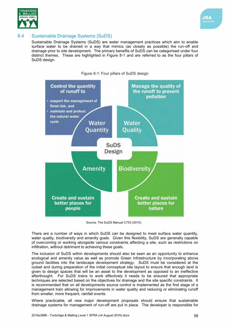
2016s3886 - Tonbridge & Malling Level 1 SFRA (v4 August 2016).docx 58
8.4 Sustainable Drainage Systems (SuDS) Sustainable Drainage Systems (SuDS) are water management practices which aim to enable surface water to be drained in a way that mimics (as closely as possible) the run-off and drainage prior to site development. The primary benefits of SuDS can be categorised under four distinct themes. These are highlighted in Figure 8-1 and are referred to as the four pillars of SuDS design.
Figure 8-1: Four pillars of SuDS design
There are a number of ways in which SuDS can be designed to meet surface water quantity, water quality, biodiversity and amenity goals. Given this flexibility, SuDS are generally capable of overcoming or working alongside various constraints affecting a site, such as restrictions on infiltration, without detriment to achieving these goals.
The inclusion of SuDS within developments should also be seen as an opportunity to enhance ecological and amenity value as well as promote Green Infrastructure by incorporating above ground facilities into the landscape development strategy. SuDS must be considered at the outset and during preparation of the initial conceptual site layout to ensure that enough land is given to design spaces that will be an asset to the development as opposed to an ineffective afterthought. For SuDS trains to work effectively it needs to be ensured that appropriate techniques are selected based on the objectives for drainage and the site specific constraints. It is recommended that on all developments source control is implemented as the first stage of a management train allowing for improvements in water quality and reducing or eliminating runoff from smaller, more frequent, rainfall events.
Where practicable, all new major development proposals should ensure that sustainable drainage systems for management of run-off are put in place. The developer is responsible for
Source: The SuDS Manual C753 (2015)

2016s3886 - Tonbridge & Malling Level 1 SFRA (v4 August 2016).docx 59
ensuring the design, construction and future/ongoing maintenance of such a scheme is carefully and clearly defined, and a clear and comprehensive understanding of the existing catchment hydrological processes and existing drainage arrangements is essential.
8.5 Types of SuDS Systems There are many different SuDS techniques that can be implemented in attempts to mimic pre-development drainage (Table 8-2). The suitability of the techniques will be dictated in part by the development proposal and site conditions. Advice on best practice is available from the Environment Agency and the Construction Industry Research and Information Association (CIRIA) e.g. the CIRIA SuDS Manual C753 (2015).
Table 8-2: Examples of SuDS techniques and potential benefits
SuDS Technique Flood
Reduction
Water Quality Treatment &
Enhancement
Landscape and Wildlife
Benefit
Living roofs
Basins and ponds Constructed wetlands Balancing ponds Detention basins Retention ponds
Filter strips and swales
Infiltration devices Soakaways Infiltration trenches and basins
Permeable surfaces and filter drains Gravelled areas Solid paving blocks Porous pavements
Tanked systems Over-sized pipes/tanks Storm cells
8.5.1 SuDS Treatment Train SuDS should not be used individually but as an interconnected system, designed to capture water at the source and convey it to a discharge location. This system is described as a SuDS Treatment Train (Figure 8-2). By using a number of SuDS features in series it is possible to reduce the flow and volume of runoff as it passes through the system, minimise the pollutants which may be generated by a development, and tailor surface water management to the local context.

2016s3886 - Tonbridge & Malling Level 1 SFRA (v4 August 2016).docx 60
Figure 8-2: SuDS Management Train
Source: Water. People. Places: A guide for master planning sustainable drainage into developments (2013)
2016s3886 - Tonbridge & Malling Level 1 SFRA (v4 August 2016).docx 61
8.5.2 Treatment A key part of the four pillars of SuDS is to provide the maximum improvement to water quality through the use of the SuDS Treatment Train. To maximise the treatment within SuDS, CIRIA recommends the following good practice guide is implemented in the treatment process:
1. Manage surface water runoff close to source: This makes treatment easier due to slower velocities. It also helps isolate incidents rather than transport pollutants over a large area.
2. Treat surface water runoff on the surface: This allows treatment to be delivered by vegetation and the sources of pollution to be more easily identified. It also helps with future maintenance work and identifying damaged or failed components of the treatment train.
3. Treat a range of contaminants: SuDS should be chosen and designed to deal with the likely contaminants that may pose a risk to the receiving environment and be able to reduce them to acceptably low levels.
4. Minimise the risk of sediment remobilisation: SuDS should be designed to prevent sediments being washed into receiving water bodies or systems during events greater than those for which the component may have been specifically designed.
5. Minimise the impact of a spill: Designing SuDS to be able to trap spills close to the course, facilitate contamination management and removal. The selected SuDS should also provide robust treatment along several components in series.
The number of treatment stages required depends primarily on the source of the runoff. The C753 SuDS Manual advises a simple index approach to determining the number of treatment stages. This involves determining a pollutant hazard score for each pollutant type. An index is then used to determine the treatment potential of different SuDS features for different pollutant types. This is known as the mitigation index. The total SuDS mitigation index should be equal or greater than the pollution hazard score to deliver adequate treatment.
8.6 Kent SuDS Guidance Information and guidance regarding SuDS design and implementation is available from a number of sources published by Kent County Council and Tonbridge and Malling Borough Council.
8.6.1 Water. People. Places: A guide for master planning sustainable drainage into developments61 The guide for master planning sustainable drainage into developments was published in 2013 by the LLFAs of the South East of England, of which Kent County Council is a part of, to outline the process for integrating SuDS into the master planning of large and small developments. The South East LLFAs expect this guidance to be used as part of the initial planning and design plans for all types of residential, commercial and industrial development. The guidance complements existing guidance on SuDS design, maintenance and operation which should also be used to inform detailed design and delivery of SuDS.
Although SuDS can be applied to any site, there are a variety of conditions and constraints that could restrict the suitability of different types of SuDS or trigger the need for bespoke design. Therefore, consideration of the movement of water and its interaction with site-specific conditions (e.g. soil types) at the earliest stage of design is crucial to the success of a SuDS scheme.
Section 4 of the ‘Water. People. Places’ document provides detailed SuDS design guidance for a range of commonly encountered site conditions. A summary of this guidance is provided in the SuDS Selection Matrix (Figure 8-3), whereby the suitability of each type of SuDS is presented for each common site condition.
It is noted in the guidance document that SuDS design should be fully integrated into a master plan as an essential part of land use and development planning, and considered in conjunction with other aspects of the design. Although there is no formal process for master planning, a typical design process for SuDS is outlined in Sections 5 and 6 of the guidance document. The process is designed to allow planners and designers to scope and embed opportunities for SuDS as land use and design ideas evolve.
61 Water. People. Places: A guide for master planning sustainable drainage into developments. Prepared by the Lead Local Flood Authorities of the South East of England (AECOM, 2013)
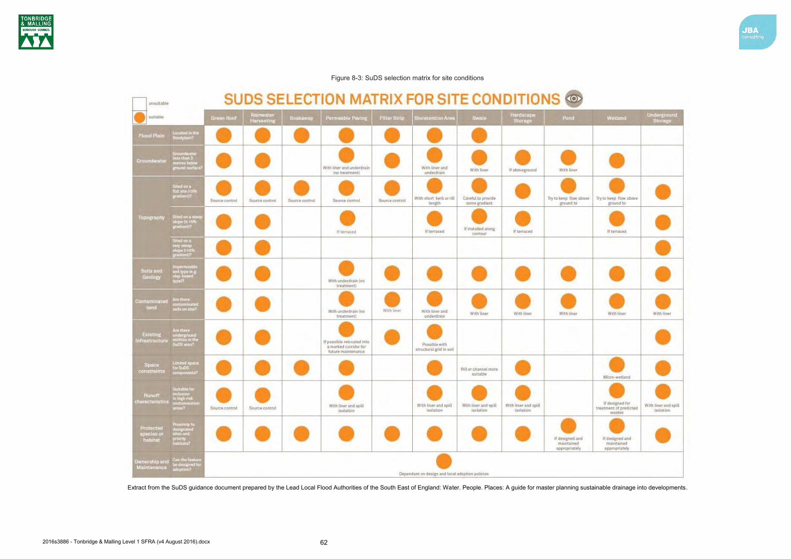
2016s3886 - Tonbridge & Malling Level 1 SFRA (v4 August 2016).docx 62
Figure 8-3: SuDS selection matrix for site conditions
Extract from the SuDS guidance document prepared by the Lead Local Flood Authorities of the South East of England: Water. People. Places: A guide for master planning sustainable drainage into developments.

2016s3886 - Tonbridge & Malling Level 1 SFRA (v4 August 2016).docx 63
8.6.2 Tonbridge and Malling Stage 1 SWMP Kent County Council state that the relevant SWMPs should also be referred to during the formulation of a SuDS scheme for a site. In this case SuDS developers should refer to the guidance provided in the Tonbridge and Malling Stage 1 SWMP. The document provides advice regarding the feasibility of SuDS across Tonbridge and Malling.
Again, it is noted that the choice of SuDS is site-specific, depending on the nature of the proposed development and local conditions. Tonbridge and Malling Borough comprises several different geologies. As a result, areas which are underlain by low permeability material may not be suitable for infiltration drainage. If discharge is proposed within a source protection zone, then additional information may be required to demonstrate that there is not an unacceptable risk to groundwater and the surrounding environment. Additional information and advice can be found on the website and within the ‘Groundwater protection: Principles and practice (GP3)62’ document.
The SWMP also states that new development should seek to incorporate SuDS to reduce surface water runoff where feasible and appropriate to the size and scale of development. The hierarchy of surface water disposal is as follows:
The use of SuDS techniques, appropriate to the location, size and type of the development.
Discharge to the watercourse.
Discharge to a surface sewer.
Discharge to a combined sewer.
8.6.3 Further information and guidance Tonbridge and Malling Borough Council have also developed several documents that provide information and guidance for integrating sustainable surface water management into developments across the borough:
Tonbridge and Malling Water Guides: SuDS63 – provides a description of the different SuDS techniques that can be potentially designed into new developments. The document also outlines several issues developers will need to consider (such as the long-term maintenance of SuDS and the requirement for applications to establish how they will be managed early in the design process) as well as a list of useful contacts.
Green Infrastructure Report64 – sets out the means and locations to consider the implementation of green infrastructure within the borough
Kent Design Guide65 – includes a technical appendix on ‘Water Efficient Homes’ which refers to the implementation of SuDS.
Along with the guidance provided by the South East LLFAs and the Stage 1 SWMP, development applications should have regard to and consider the above documents during the design and delivery of SuDS for all types of development.
8.7 Groundwater Vulnerability Zones The Environment Agency published new groundwater vulnerability maps in 2015. These maps provide a separate assessment of the vulnerability of groundwater in overlying superficial rocks and those that comprise the underlying bedrock. The maps show the vulnerability of groundwater at a location based on the hydrological, hydrogeological and soil properties within a one kilometre grid square.
62 Groundwater protection: principles and practice (GP3), (Environment Agency, 2013). 63 Water Guides: Sustainable Drainage Systems (SuDS), (Tonbridge and Malling Borough Council, 2010). 64 Development Plan Document: Green Infrastructure Report - Part of the Local Development Framework for Tonbridge and Malling, (March, 2009). 65 The Kent Design Guide
2016s3886 - Tonbridge & Malling Level 1 SFRA (v4 August 2016).docx 64
Two maps are available:
Basic groundwater vulnerability map: this shows the likelihood of a pollutant discharged at ground level (above the soil zone) reaching groundwater for superficial and bedrock aquifers and is expressed as high, medium and low vulnerability
Combined groundwater vulnerability map: this map displays both the vulnerability and aquifer designation status (principal or secondary). The aquifer designation status is an indication of the importance of the aquifer for drinking water supply.
The groundwater vulnerability maps should be considered when designing SuDS.
8.8 Groundwater Source Protection Zones (GSPZ) In addition to the Areas Susceptible to Ground Water Flooding (AStGWF) data the Environment Agency also defines Groundwater Source Protection Zones in the vicinity of groundwater abstraction points. These areas are defined to protect areas of groundwater that are used for potable supply, including public/private potable supply, (including mineral and bottled water) or for use in the production of commercial food and drinks. The GSPZ requires attenuated storage of runoff to prevent infiltration and contamination. The definition of each zone is noted below:
Zone 1 (Inner Protection Zone) – Most sensitive zone: defined as the 50-day travel time from any point below the water table to the source. This zone has a minimum radius of 50 metres
Zone 2 (Outer Protection Zone) – Also sensitive to contamination: defined by a 400-day travel time from a point below the water table. This zone has a minimum radius around the source, depending on the size of the abstraction
Zone 3 (Total Catchment) - Defined as the area around a source within which all groundwater recharge is presumed to be discharged at the source. In confined aquifers, the source catchment may be displaced some distance from the source. For heavily exploited aquifers, the final Source Catchment Protection Zone can be defined as the whole aquifer recharge area where the ratio of groundwater abstraction to aquifer recharge (average recharge multiplied by outcrop area) is >0.75. Individual source protection areas will still be assigned to assist operators in catchment management
Zone 4 (Zone of Special Interest) – A fourth zone SPZ4 or ‘Zone of Special Interest’ usually represents a surface water catchment which drains into the aquifer feeding the groundwater supply (i.e. catchment draining to a disappearing stream). In the future this zone will be incorporated into one of the other zones, SPZ 1, 2 or 3, whichever is appropriate in the particular case, or become a safeguard zone
8.8.1 GSPZs in Tonbridge and Malling Borough Twelve GSPZs have been identified in Tonbridge and Malling Borough. They are located in the following areas and are displayed in Figure 8-4:
Pratling Street, Aylesford
Papyrus Way, Aylesford
Cobdown Wood, Ditton
M20, east of the Royal British Legion Village
Paddlesworth Road, West Malling
Park Farm Road, Ryarsh
Ford Lane, West Malling
Wrotham Water Road, Sevenoaks
Invicta Business Park, Wrotham
Tolsey Mead, Borough Green
The Sports Ground, Tonbridge
Hartlake Road, Tonbridge
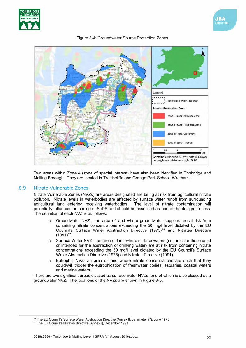
2016s3886 - Tonbridge & Malling Level 1 SFRA (v4 August 2016).docx 65
Figure 8-4: Groundwater Source Protection Zones
Two areas within Zone 4 (zone of special interest) have also been identified in Tonbridge and Malling Borough. They are located in Trottiscliffe and Grange Park School, Wrotham.
8.9 Nitrate Vulnerable Zones Nitrate Vulnerable Zones (NVZs) are areas designated are being at risk from agricultural nitrate pollution. Nitrate levels in waterbodies are affected by surface water runoff from surrounding agricultural land entering receiving waterbodies. The level of nitrate contamination will potentially influence the choice of SuDS and should be assessed as part of the design process. The definition of each NVZ is as follows:
o Groundwater NVZ – an area of land where groundwater supplies are at risk from containing nitrate concentrations exceeding the 50 mg/l level dictated by the EU Council’s Surface Water Abstraction Directive (1975)66 and Nitrates Directive (1991)67.
o Surface Water NVZ – an area of land where surface waters (in particular those used or intended for the abstraction of drinking water) are at risk from containing nitrate concentrations exceeding the 50 mg/l level dictated by the EU Council’s Surface Water Abstraction Directive (1975) and Nitrates Directive (1991).
o Eutrophic NVZ- an area of land where nitrate concentrations are such that they could/will trigger the eutrophication of freshwater bodies, estuaries, coastal waters and marine waters.
There are two significant areas classed as surface water NVZs, one of which is also classed as a groundwater NVZ. The locations of the NVZs are shown in Figure 8-5.
66 The EU Council’s Surface Water Abstraction Directive (Annex II, parameter 7*), June 1975 67 The EU Council’s Nitrates Directive (Annex I), December 1991
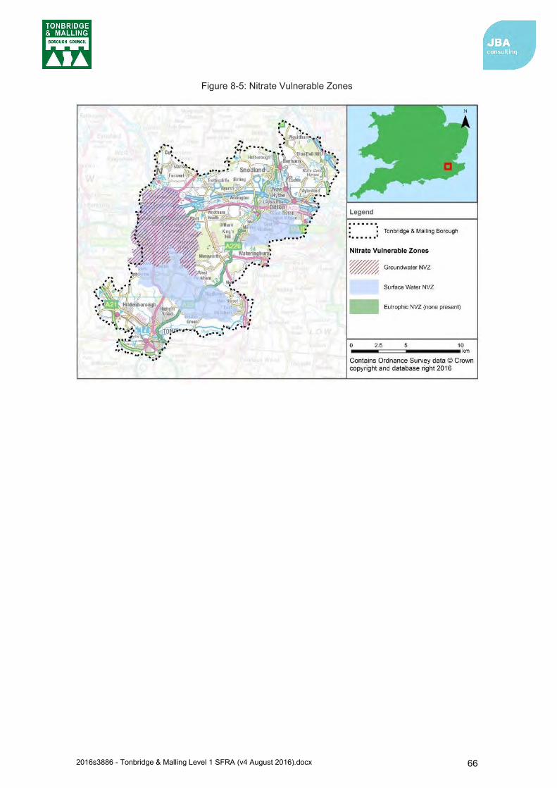
2016s3886 - Tonbridge & Malling Level 1 SFRA (v4 August 2016).docx 66
Figure 8-5: Nitrate Vulnerable Zones

2016s3886 - Tonbridge & Malling Level 1 SFRA (v4 August 2016).docx 67
Emergency planning and flood risk management links
2004 Civil Contingencies Act: http://www.legislation.gov.uk/ukpga/2004/36/contents
DEFRA (2014) National Flood Emergency Framework for England: https://www.gov.uk/government/publications/the-national-flood-emergency-framework-for-england
Government guidance for public safety and emergencies is available at: https://www.gov.uk/topic/public-safety-emergencies/emergencies-preparation-response-recovery
9 Flood warning and emergency planning 9.1 Flood emergencies
The evidence used to prepare this SFRA report demonstrates that Tonbridge and Malling Borough is affected by flood risk hazards and that particular communities are potentially vulnerable to flooding during events that exceed the design capacity of the defences, or from failure of those defences (residual risk)
Emergency planning is an option to help manage flood related incidents and is relevant in circumstances where there is a residual risk of flooding. Emergency planning is a core component of civil protection and public safety practices and seeks primarily to prevent, or secondly mitigate the risk to life, property, businesses, infrastructure and the environment. In the UK, emergency planning is performed under the direction of the 2004 Civil Contingencies Act (CCA).
From a flood risk perspective, emergency planning can be broadly split into three phases: before, during and after a flood. The measures involve developing and maintaining arrangements to reduce, control or mitigate the impact and consequences of flooding and to improve the ability of people and property to absorb, respond to and recover from flooding. In development planning, a number of these activities are already integrated in national building control and planning policies e.g. the NPPF.
Safety is a key consideration for any new development and includes the likely impacts of climate change and, where there is a residual risk of flooding, the availability of adequate flood warning systems for the development, safe access and egress routes and evacuation procedures. It is a requirement under the NPPF that a flood warning and evacuation plan is prepared for sites at risk of flooding used for holiday or short-let caravans and camping and are important at any site that has transient occupants (e.g. hostels and hotels)68 and for essential ancillary sleeping or residential accommodation for staff required by uses in this category [water-compatible development], subject to a specific warning and evacuation plan. Flood warning and evacuation plans may also be referred to as an emergency flood plan or flood response plan.
9.2 Existing Flood Warning Systems The Environment Agency is the lead organisation for providing warnings of fluvial flooding (for watercourses classed as Main Rivers) and coastal flooding in England. The Environment Agency supplies Flood Warnings via the Floodline Warnings Direct (FWD) service, to homes and business within Flood Zones 2 and 3, and this covers, fluvial, tidal and coastal flooding. Using the latest available technology, Environment Agency staff monitor rainfall, river levels and sea conditions 24 hours a day and use this information to forecast the possibility of flooding. If flooding is forecast, warnings are issued using a set of four easily recognisable codes, shown below in Table 9-1. Generic advice and examples on actions to be taken on receipt of the warning are shown in the column called “What to do”.
Flood warnings are disseminated to people registered to receive flood warnings via the FWD service using the following communication methods; phone, text and / or e-mail. Warnings may also be reported in news and weather bulletins. The Environment Agency have a Floodline number (0345 988 1188) and a quick-dial number specific to the Flood Warning Area, which the public can call to receive more detailed information regarding the flood warning.
68 NPPF Planning Practice Guidance: Flood Risk and Coastal Change (paragraph 056, Reference ID: 7-056-20140306) March 2014

2016s3886 - Tonbridge & Malling Level 1 SFRA (v4 August 2016).docx 68
It is the responsibility of individuals to sign-up this service, in order to receive the flood warnings via FWD. Registration and the service are free and publically available. It is recommended that any household considered at risk of flooding signs-up. Developers should also encourage those owning or occupying developments, where flood warnings can be provided, to sign up to receive them. This applies even if the development is defended to a high standard.
Tonbridge and Malling falls within the Kent and South London Environment Agency Area.
Table 9-1: Environment Agency Flood Warnings Explained
Flood Warning Symbol What it means What to do
Flood Alerts are used to warn people of the possibility of flooding and encourage them to be alert, stay vigilant and make early preparations. It is issued earlier than a flood warning, to give customers advice notice of the possibility of flooding, but before we are fully confident that flooding in Flood Warning Areas is expected.
Be prepared to act on your flood plan
Prepare a flood kit of essential items
Monitor local water levels and the flood forecast on the Environment Agency website
Stay tuned to local radio or TV Alert your neighbours Check pets and livestock Reconsider travel plans
Flood Warnings warn people of expected flooding and encourage them to take action to protect themselves and their property.
Move family, pets and valuables to a safe place
Turn off gas, electricity and water supplies if safe to do so
Seal up ventilation system if safe to do so
Put flood protection equipment in place
Be ready should you need to evacuate from your home
‘Go In, Stay In, Tune In’
Severe Flood Warnings warn people of expected severe flooding where there is a significant threat to life.
Stay in a safe place with a means of escape
Co-operate with the emergency services and local authorities
Call 999 if you are in immediate danger
Informs people that river or sea conditions begin to return to normal and no further flooding is expected in the area. People should remain careful as flood water may still be around for several days.
Be careful. Flood water may still be around for several days
If you've been flooded, ring your insurance company as soon as possible
9.2.1 Flood Alert and Warning Areas in Tonbridge and Malling Borough There are currently three Flood Alert Areas and seven Flood Warning Areas covering Tonbridge and Malling Borough. The coverage of the Flood Alerts and Flood Warning Areas is mainly in the south of the borough, with the exception of the tidal Medway in the north. Approximately 20% of the borough is located within a Flood Alert or Warning Area.
Appendix G shows the FWA coverage for Tonbridge and Malling Borough. If your home or business falls within the FWA coverage, this means that the Environment Agency can provide you with flood warnings.
Warnings no
longer in force
2016s3886 - Tonbridge & Malling Level 1 SFRA (v4 August 2016).docx 69
9.2.2 Groundwater alerts In selected areas, the Environment Agency can provide a groundwater alert / warning. These tend to be for communities located on chalk bedrock or known have a history of groundwater flooding69. If a groundwater alert is issued, this does not necessarily mean that properties within its coverage are definitely at risk. The Environment Agency note that the alerts cover large areas that could be affected if groundwater levels are high and that groundwater is difficult to predict as the location of the flooding is normally related to the local geology. The Environment Agency only provide a limited groundwater alert service and this does not currently cover the Tonbridge and Malling area.
9.3 Lead times and onset of flooding Flood alerts and warnings provide advanced notification that flooding is possible or expected. The time from when the alert or warning is issued to the onset of property flooding (termed the lead time) can provide time for people to prepare for flooding (see the “What to do” column in Table 9-1). The Environment Agency endeavour to give a two-hour lead time for issuing Flood Warnings; however, for fast responding catchments and areas at risk of flash flooding, this may not be possible.
A failure or breach of flood defences can cause immediate and rapid inundation to areas located near the vicinity of the breach or failure. Such incidents can pose a significant risk to life given the near lack of warning and lead time to prepare or respond.
For developers it is therefore important to consider how to manage the consequences of events that are un-foreseen or for which no warnings can be provided. A typical example would be managing the residual risk of a flood defence breach or failure (see section 3.2.3 for further information on residual risk).
9.4 Managing flood emergencies Kent County Council’s Kent Resilience Forum (KRF) is one of a number of Local Resilience Forums (LRFs) that have bene set up across England. The overall aim of an LRF is to ensure that the various agencies and organisations plan and subsequently work together so that responses to emergencies are coordinated appropriately70. The KRF is made up of a number of different agencies and organisations that work together across a range of areas including planning for emergencies.
9.4.1 Kent County Council Flood Response Plan The Kent County Council Flood Response Plan (July 2015) sets out the principles that govern the Kent County Council’s response to a significant flooding event within their local authority administrative area. The Plan was produced to meet the requirements of the Civil Contingencies Act 2004, and is built upon the existence and maintenance by Category 1 and 2 Responders of their own plans for response to flooding.
69 Environment Agency (2014) Flood Warning Data Integrity Guide 70 Kent County Council: Flood Risk to Communities Tonbridge and Malling (March 2016)
There are currently no national systems offering flood warnings for flooding from Ordinary Watercourses, surface water, sewer, road and drainage sources or reservoir / flood management infrastructure failure.
2016s3886 - Tonbridge & Malling Level 1 SFRA (v4 August 2016).docx 70
Category 1 Responders for Tonbridge and Malling are:
Kent County Council Tonbridge and Malling Borough Council Kent Police Kent Fire and Rescue Service South East Coast Ambulance Service Environment Agency
The Category 2 Responders for Tonbridge and Malling are utility providers, such as Southern Water.
The response plan provided information on Kent County Council’s actions, roles and responsibility in response to a flood in their administrative area.
9.4.2 Tonbridge and Malling Borough Council’s Emergency Plan Tonbridge and Malling Borough Council work with Kent County Council, the emergency services and the Environment Agency to coordinate the response during severe flooding71. Tonbridge and Malling Council responsibilities include:
To set up rest centres for people who are evacuated and unable to stay with family or friends, and to also arrange temporary housing.
To support other Category 1 and 2 responders and provide resources (where required and in the remit of the local authority).
To try and mount a reasonable flood defence response by making sandbags available at the locations of high risk.
Sandbags have been traditionally used to block doorways, drains and other openings to properties. Sandbags are not waterproof and will be unable to permanently prevent the ingress of water to an area protected by them.
The provision of sandbags is not a statutory function of Tonbridge and Malling Borough Council. The Council has a sandbag policy which outlines the criteria for providing sandbags, the decision making process used to determine the provision of sandbags, how the sandbags will be delivered and the means for their disposal.
In the midst of a flood emergency it cannot be guaranteed that sandbags will be delivered in sufficient time or quantities to prevent/reduce damage to a property due to the limited stocks available72.
The Environment Agency has produced a guidance document on how to use sandbags properly for flood protection, downloadable from their website.
Evacuation If a decision is made to evacuate then the responsibility to lead the evacuation falls upon the Police, with other agencies aiding. Decisions to evacuate are not taken lightly and are based on information relating to public safety and expected ground conditions. The preference to evacuate will always be to do so when it is deemed safe, i.e. before water has reached or entered a property.
Flood Wardens As part of the Tonbridge and Malling Borough Council’s Emergency Plan, Flood Wardens have been allocated to areas where flooding can be managed effectively. These Flood Wardens are local volunteers and are trained by the Kent Resilience Team. The role of the Flood Warden involves:
Keeping an eye on the local watercourses.
71 Tonbridge and Malling Borough Council: Emergency Flooding 72 Kent County Council: Flood Risk to Communities Tonbridge and Malling (March 2016)
2016s3886 - Tonbridge & Malling Level 1 SFRA (v4 August 2016).docx 71
Use their own local knowledge to recognise and report flood risks. Relay messages about potential flooding to others in the area they cover. Provide emergency services with important information in the event of a flood.
The role of a flood warden is primarily to observe and report, they should not place themselves in any danger, take responsibility for moving or protecting anyone’s property, or clear ditches or culverts. To find out who your local Flood Warden is, or if you would like to volunteer to become a Flood Warden, then contact Tonbridge and Malling Council.
9.4.3 Addington Parish Council: Community Emergency Plan As part of the Kent Resilience Forum, Addington Parish Council has set up their own Community Emergency Plan (June 2015). This is understood to be the only emergency plan produced by a parish within the Tonbridge and Malling Borough, but it is advisable to check this remains the case when considering development within an area. If a community emergency plan is available, the content of this should be considered alongside the context of the proposed development.
The aim of the plan is to provide a local framework that will increase the readiness and resilience within the community of Addington. The plan enables Addington Parish Council and other community groups to support themselves when outside assistance from the emergency services or local authority is delayed or overwhelmed. Flooding has been included as one of the local risks to the community. The plan identifies local resources available, which include the use of rest centres. Allocated rest centres in Addington are:
Seeks Trust, Park Road; The Angle Inn, Trottiscliffe Road; West Malling Golf Club, Trottiscliffe Road; Jungle Café, London Road/A20.
9.5 Emergency planning and development
9.5.1 NPPF The NPPF Flood Risk Vulnerability and Flood Zone ‘Compatibility’ table seeks to avoid inappropriate development in areas at risk from all sources of flooding. It is essential that any development which will be required to remain operational during a flood event is located in the lowest flood risk zones to ensure that, in an emergency, operations are not impacted on by flood water or that such infrastructure is resistant to the effects of flooding such that it remains serviceable/operational during ‘upper end’ events, as defined in the Environment Agency’s climate change guidance. For example, the NPPF classifies police, ambulance and fire stations and command centres that are required to be operational during flooding as Highly Vulnerable development, which is not permitted in Flood Zones 3a and 3b and only permitted in Flood Zone 2 providing the Exception Test is passed. Essential infrastructure located in Flood Zone 3a or 3b must be operational during a flood event to assist in the emergency evacuation process. All flood sources such as fluvial, surface, groundwater, sewers and artificial sources (such as canals and reservoirs) should be considered. In particular, sites for proposed development should be considered in relation to the areas of drainage critical problems highlighted in the Tonbridge and Malling, and Maidstone and Malling SWMPs.
The outputs of this SFRA should be compared and reviewed against any emergency plans and continuity arrangements within Tonbridge and Malling. This includes the nominated rest and reception centres (and prospective ones), so that evacuees are outside of the high risk flood zones and will be safe during a flood event.
9.5.2 Safe access and egress The NPPF Planning Practice Guidance outlines how developers can secure safe access and egress to and from development in order to demonstrate that development satisfies the second part of the Exception Test73. Access considerations should include the voluntary and free
73 NPPF Planning Practice Guidance: Flood Risk and Coastal Change (paragraph 039, Reference ID: 7-056-20140306)
2016s3886 - Tonbridge & Malling Level 1 SFRA (v4 August 2016).docx 72
movement of people during a ‘design flood’ as well as for the potential of evacuation before a more extreme flood. The access and egress must be functional for changing circumstances over the lifetime of the development. The NPPF Planning Practice Guidance sets out that
access routes should allow occupants to safely access and exit their dwellings in design flood conditions. In addition, vehicular access for emergency services to safely reach development in design flood conditions is normally required; and
where possible, safe access routes should be located above design flood levels and avoid flow paths including those caused by exceedance and blockage. Where this is unavoidable, limited depths of flooding may be acceptable providing the proposed access is designed with appropriate signage etc. to make it safe. The acceptable flood depth for safe access will vary as this will be dependent on flood velocities and risk of debris in the flood water. Even low levels of flooding can pose a risk to people in situ (because of, for example, the presence of unseen hazards and contaminants in floodwater, or the risk that people remaining may require medical attention).
The depth, velocity and hazard mapping from hydraulic modelling should help inform the provision of safe access and egress routes.
As part of an FRA, the developer should review the acceptability of the proposed access in consultation with Tonbridge and Malling Borough Council and the Environment Agency. Site and plot specific velocity and depth of flows should be assessed against standard hazard criteria to ensure safe access and egress can be achieved.
9.5.3 Potential evacuations During flood incidents, evacuation may be considered necessary. The NPPF Planning Guidance states practicality of safe evacuation from an area will depend on74
1. the type of flood risk present, and the extent to which advance warning can be given in a flood event;
2. the number of people that would require evacuation from the area potentially at risk; 3. the adequacy of both evacuation routes and identified places that people could be
evacuated to (and taking into account the length of time that the evacuation may need to last); and
4. sufficiently detailed and up to date evacuation plans being in place for the locality that address these and related issues.
The vulnerability of the occupants is also a key consideration. The NPPF and application of the Sequential Test aims to aims to avoid inappropriate development in flood risk areas. However, developments may contain proposals for mixed use on the same site. In this instance, the NPPF Planning Practice Guidance states that layouts should be designed so that the most vulnerable uses are restricted to higher ground at lower risk of flooding, with development which has a lower vulnerability (parking, open space, etc.) in the highest risk areas, unless there are overriding reasons to prefer a different location75. Where the overriding reasons cannot be avoided, safe and practical evacuation routes must be identified.
The Environment Agency and DEFRA provide standing advice for undertaking FRAs for planning applications. Please refer to the government website for the criteria on when to follow the standing advice. Under these criteria, you will need to provide details of emergency escape plans for any parts of the building that are below the estimated flood level. The plans should show
single storey buildings or ground floors that do not have access to higher floors can access a space above the estimated flood level, e.g. higher ground nearby;
March 2014 74 NPPF Planning Practice Guidance: Flood Risk and Coastal Change (paragraph 057, Reference ID: 7-057-20140306) March 2014 75 NPPF Planning Practice Guidance, Reducing the causes and impacts of flooding Paragraph: 053 Reference ID: 7-053-20140306

2016s3886 - Tonbridge & Malling Level 1 SFRA (v4 August 2016).docx 73
Guidance documents for preparation of flood response
plans Environment Agency (2012)
Flooding – minimising the risk, flood plan guidance for communities and groups
Environment Agency (2014) Community Flood Plan template
Environment Agency Personal flood plans
Flood Plan UK ‘Dry Run’ - A Community Flood Planning Guide
basement rooms have clear internal access to an upper level, e.g. a staircase; and occupants can leave the building if there is a flood and there is enough time for them to
leave after flood warnings76. Situations may arise where occupants cannot be evacuated (e.g. prisons) or where it is safer to remain “in-situ” and / or move to a higher floor or safe refuge area (e.g. developments located immediately behind a defence and at risk of a breach). These allocations should be assessed against the outputs of the SFRA and where applicable, a site-specific FRA to help develop appropriate emergency plans.
9.5.4 Flood warning and evacuation plans Flood warning and evacuation plans are potential mitigation measure to manage the residual risk, as stated in the NPPF Planning Practice Guidance. It is a requirement under the NPPF that a flood warning and evacuation plan is prepared for sites at risk of flooding used for holiday or short-let caravans and camping and are important at any site that has transient occupants (e.g. hostels and hotels); and
A flood warning and evacuation plan should detail arrangements for site occupants on what to do before, during and after a flood as this will help to lessen its impact, improve flood response and speed up the recovery process. The Environment Agency provides practical advice and templates on how to prepare a flood plan for individuals, communities and businesses (see text box for useful links).
It is recommended that emergency planners at Tonbridge and Malling Borough Council are consulted prior to the production of any emergency flood plan. The Council will provide guidance to help local communities to protect their home and valuables and understand what to do before, during and after a flood, as shown under Objective 5 of the Kent LFRMS. Once the emergency flood plan is prepared, it is recommended that it is distributed to emergency planners at Tonbridge and Malling Borough Council and the emergency services. When developing a flood warning and evacuation plan, it is recommended that it links in with any existing parish / community level plan.
9.5.5 Other sources of information
As well as being a statutory consultee for new development at risk of flooding, the Environment Agency can offer independent technical advice. The Environment Agency website contains a breadth of information on flood risk and there are numerous publications and guidance available. For example, the “flooding from groundwater” guide has been produced by the Environment Agency and Local Government Association to offer practice advice to reduce the impact of flooding from groundwater.
76 Environment Agency and DEFRA (2012) Flood Risk Assessment: Standing Advice: https://www.gov.uk/flood-risk-assessment-standing-advice
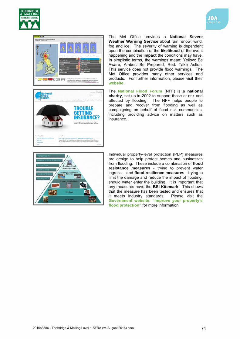
2016s3886 - Tonbridge & Malling Level 1 SFRA (v4 August 2016).docx 74
The Met Office provides a National Severe Weather Warning Service about rain, snow, wind, fog and ice. The severity of warning is dependent upon the combination of the likelihood of the event happening and the impact the conditions may have. In simplistic terms, the warnings mean: Yellow: Be Aware, Amber: Be Prepared, Red: Take Action. This service does not provide flood warnings. The Met Office provides many other services and products. For further information, please visit their website.
The National Flood Forum (NFF) is a national charity, set up in 2002 to support those at risk and affected by flooding. The NFF helps people to prepare and recover from flooding as well as campaigning on behalf of flood risk communities, including providing advice on matters such as insurance.
Individual property-level protection (PLP) measures are design to help protect homes and businesses from flooding. These include a combination of flood resistance measures - trying to prevent water ingress – and flood resilience measures - trying to limit the damage and reduce the impact of flooding, should water enter the building. It is important that any measures have the BSI Kitemark. This shows that the measure has been tested and ensures that it meets industry standards. Please visit the Government website: “improve your property’s flood protection” for more information.
2016s3886 - Tonbridge & Malling Level 1 SFRA (v4 August 2016).docx 75
10 Strategic flood risk solutions 10.1 Introduction
Strategic flood risk solutions may offer potential opportunity to reduce flood risk in Tonbridge and Malling Borough. As described in Section 2.5, the areas of Tonbridge and East Peckham have been assigned Policy 5 under the River Medway CFMP, which means further action can be taken to reduce flood risk. Of the actions identified in the CFMP, three are applicable to strategic flood risk solutions in the borough. More detailed strategic information on proposed strategic measures and approaches can be found in the Thames River Basin District Flood Risk Management Plan - Parts A, B, C and D77.
The first relates to encouraging compatibility between urban open spaces and their ability to make space for rivers to expand and flood flows to occur, as outlined in the Middle Medway Strategy78. Use of flood storage schemes and floodplain restoration can help towards this action. Further details are provided in the following sections. The second relates to further developing local emergency response plans to mitigate flood risk across the borough. The third relates to ensuring floodplains are not inappropriately developed; the guidance for planners and developers set out within this document and by Tonbridge and Malling Borough Council should ensure this action is followed.
10.1.1 Middle Medway Strategy The Middle Medway Strategy (MMS) was completed in August 2005 and investigated flood risk management options for the Middle Medway catchment through modelling, economic and strategic environment assessment79. The strategy was intended to guide those involved in flood defence and planning to present a business case to justify future works and investment in flood risk management80. The MMS was revised in 2010 to set out options to manage flood risk from the River Medway, the River Beult and the River Teise81.
The options outlined included enlarging the capacity of the Leigh FSA from 5.5 million cubic metres to 8.8 million cubic metres to improve the standard of protection for homes in Tonbridge and along the fluvial River Medway. The MMS also recommended a second FSA scheme on the River Beult to reduce the risk of flooding to Yalding and the surrounding areas. Implementing outcomes of the MMS is also something reinforced within the River Thames Flood Risk Management Plan (2016)82.
Along with increasing the FSA in the Medway catchment, the River Medway CFMP notes that the outcomes of the MMS should be implemented, including consideration of new flood walls or earth embankments at East Peckham83. Also noted in the CFMP is consideration of flood-proofing properties, where appropriate (refer to section 2.5).
10.2 Flood defences Formal flood defences in Tonbridge and Malling borough are located in Tonbridge and at the tidal River Medway downstream of Allington (see section 6.3 for details). A number of potential sites identified within the borough could be influenced by the presence of these defences. At these locations it will be important to understand the benefit that defences can have on reducing flooding, and consequences if their design standard is exceeded or they fail.
Flood mitigation measures should only be considered if, after application of the Sequential Approach, development sites cannot be located away from higher risk areas. If defences are
77 Environment Agency, Thames River Basin District Flood Risk Management Plan 2015-2021 Part C (March 2016). Available: https://www.gov.uk/government/uploads/system/uploads/attachment_data/file/507148/LIT_10231_THAMES_ FRMP_PART_C.pdf 78 Environment Agency, Middle Medway Strategy Study for Flood Risk Management – Project Appraisal Report (2005) 79 Environment Agency: Middle Medway Strategy Study for Flood Risk Management – Project Appraisal Report (2005) 80 Environment Agency: Middle Medway Strategy Study for Flood Risk Management – Project Appraisal Report (2005) 81 Environment Agency, River Medway Flood Storage Areas (FSAs) Project (2015). Available: https://www.gov.uk/government/publications/river-medway-flood-storage-areas-fsas-project/river-medway-flood-storage-areas-fsas-project 82 Environment Agency, Thames River Basin District Flood Risk Management Plan 2015-2021 Part C (March 2016). Available: https://www.gov.uk/government/uploads/system/uploads/attachment_data/file/507148/LIT_10231_THAMES_ FRMP_PART_C.pdf 83 Environment Agency: River Medway Catchment Flood Management Plan (2009)
2016s3886 - Tonbridge & Malling Level 1 SFRA (v4 August 2016).docx 76
constructed to protect a development site, it will need to be demonstrated that the defences will not have a resulting negative impact on flood risk elsewhere, and that there is no net loss in floodplain storage.
10.3 Flood storage schemes Flood storage schemes aim to reduce the flows passed downriver to mitigate downstream flooding. Development increases the impermeable area within a catchment, creating additional and faster runoff into watercourses. Some flood storage schemes aim to detain this additional runoff brought about by development, releasing it downstream at a slower rate, to avoid any increase in flood depths and/or frequency downstream. Methods to provide these schemes include84:
Enlarging the river channel Raising the riverbanks Constructing flood banks set back from the river Implementation of SuDS storage schemes
Flood storage schemes have the advantage that they generally benefit areas downstream, not just the local area. Benefits of a flood storage area may therefore cross local authority borders to those for instance further downstream along the River Medway.
The construction of new upstream storage schemes as part of upstream catchment-based approaches on watercourses in Tonbridge and Malling borough could provide one potential strategic solution to flood risk. Watercourses which are rural in their upper reaches but have high levels of flood risk to urban areas in the downstream reaches are potential candidates, as the open land in the upper reaches can potentially provide the space for an attenuation area, providing benefit to the urban area downstream. For Tonbridge, this may be most likely to involve potential capacity increases at Leigh FSA, which is located a relatively short distance upstream of Tonbridge.
Opportunities to work with natural processes to reduce flood and erosion risk, benefit the natural environment, and reduce cost of schemes should be sought. This requires integrated catchment management and involving those who use and shape the land. It also requires partnership working with neighbouring authorities, organisations and water management bodies.
Conventional flood prevention schemes listed above will likely still be preferred, but consideration of ‘re-wilding’ rivers upstream could provide cost efficiencies as well as considering multiple sources of flood risk; for example, through wider land management practices (e.g. woodland management, creation of upland wetlands and managed farming practices) or building earth banks to capture runoff, could be cheaper and smaller-scale measures than implementing flood walls for example. Again, this may require partnership working with neighbouring authorities and landowners. With flood prevention schemes, consideration needs to be given to the impact that flood prevention has on the WFD status of watercourses. It is important that any potential schemes do not have a negative impact on the ecological and chemical status of waterbodies.
Possible locations for potential flood storage schemes have been identified by the MMS and River Medway FSA project by the Environment Agency85. A potential location recommended is upstream of Yalding on the River Beult. Storage schemes may not only reduce flood risk from the watercourse further downstream, but may also reduce flood risk from the River Medway in the borough. The potential for this scheme is currently being investigated by the Environment Agency and the business case for this scheme will be considered by Defra in 201886.
84 Environment Agency: Fluvial Design Guide – Chapter 10 (2010) 85 Environment Agency, River Medway Flood Storage Areas (FSAs) Project (2015). Available: https://www.gov.uk/government/publications/river-medway-flood-storage-areas-fsas-project/river-medway-flood-storage-areas-fsas-project 86 Environment Agency, River Medway Flood Storage Areas (FSAs) Project (2015). Available: https://www.gov.uk/government/publications/river-medway-flood-storage-areas-fsas-project/river-medway-flood-storage-areas-fsas-project
2016s3886 - Tonbridge & Malling Level 1 SFRA (v4 August 2016).docx 77
Expansion of existing FSAs could also decrease the flood risk in the borough. The Environment Agency is currently planning to expand Leigh FSA, with work commencing in 201887. There is also potential to increase the capacity East Peckham FSA. Refer to section 6.5 for further information on potential flood risk management schemes.
10.3.1 Promotion of SuDS Surface water flood risk is present across parts of the borough. By considering SuDS at an early stage in the development of a site, the risk from surface water can be mitigated to a certain extent within the site as well as reduce the risk that the site poses to third party land. Regionally, SuDS should be promoted on all new developments to ensure the quantity and quality of surface water is dealt with sustainably to reduce flood risk. Given the detailed policies and guidance produced by the LLFA (summarised in section 8) Tonbridge and Malling Borough Council should actively promote developers to use this information to produce technically proficient and sustainable drainage solutions.
10.4 Floodplain restoration Compared to flood defences and flood storage, floodplain restoration represents the most sustainable form of strategic flood risk solution, by allowing watercourses to return to a more naturalised state, and by creating space for naturally functioning floodplains working with natural processes.
Although the restoration of floodplain is difficult in previously developed areas where development cannot be rolled back, the following measures could be considered:
Promoting existing and future brownfield sites that are adjacent to watercourses to naturalise banks as much as possible. Buffer areas around watercourses provide an opportunity to restore parts of the floodplain
Removal of redundant structures to reconnect the river and the floodplain. There are a number of culverted sections of watercourse located throughout the borough which if returned to a more natural state would potentially reduce flood risk to the local area
Apply the Sequential Approach to avoid new development within currently undefended floodplain.
10.5 Engaging with key stakeholders Flood risk to an area or development can often be attributed to a number of sources such as fluvial, surface water and/or groundwater. In rural areas the definition between each type of flood risk is more distinguished. However, within urban areas flooding from multiple sources can become intertwined. Where complex flood risk issues are highlighted it is important that all stakeholders are actively encouraged to work together to identify issues and provide suitable solutions.
Engagement with riparian owners is also important to ensure they understand their rights and responsibilities including:
maintaining river bed and banks;
allowing the flow of water to pass without obstruction; and
controlling invasive alien species e.g. Japanese knotweed.
More information about riparian owner responsibilities can be found in the Environment Agency’s publication ‘Living on the Edge’ (2012).
87 Kent County Council: Flood Risk to Communities Tonbridge and Malling (March 2016)

2016s3886 - Tonbridge & Malling Level 1 SFRA (v4 August 2016).docx 78
11 Development control recommendations 11.1 Overview
There are a number of policy considerations relating to flood risk management in Tonbridge and Malling Borough, which are set out in sections 2 and 8. This chapter sets out recommendations for considering and assessing flood risk in Tonbridge and Malling Borough.
11.2 Development control policy The following recommendations have been identified for flood risk policy for new development. The first recommendations are relevant to all development regardless of the Flood Zone they are in. The remaining recommendations are relevant to specific Flood Zones (note some policies are relevant to more than one flood zone and hence will have been repeated).
Recommendations relevant for development in all Flood Zones (1, 2, 3a, 3b)
Where Flood Zones do not currently exist for smaller watercourses and drains (those with a catchment area less than 3km2), the uFMfSW can give a broad indication of the potential flow path and flood extent from these watercourses. At the planning application stage, developers would be expected to undertake more detailed hydrological and hydraulic assessments of the watercourses to verify flood extents, inform development zoning within the site and prove, if required, whether the Exception Test can be passed. The assessment should also identify the risk of existing flooding to adjacent land and properties to establish whether there is a requirement to secure land to implement strategic flood risk management measures to alleviate existing and future flood risk
A FRA is required for all developments over 1ha and should be proportionate to the degree of flood risk, as well as the scale, nature and location of the development. The LPA and Environment Agency should be consulted to confirm the level of assessment required and to provide any information on any known local issues.
The LPA should consult the Environment Agency’s ‘Flood Risk Standing Advice (FRSA) for Local Planning Authorities’, when reviewing planning applications for proposed developments at risk of flooding
It should be demonstrated through a Surface Water Drainage Strategy, that the proposed drainage scheme, and site layout and design, will prevent properties from flooding from surface water, allowing for climate change effects. They should also show that flood risk elsewhere will not be exacerbated by increased levels of surface runoff. Consideration must also be given to residual risk and maintenance of sustainable drainage and surface water systems
Surface water runoff management should be undertaken, through the utilisation of appropriate SuDS techniques, prioritising the use of surface SuDS features which provide additional benefits (e.g. biodiversity, amenity space)
Normally no buildings should be constructed within eight metres of the banks of watercourses. This is to allow access for maintenance, as well as providing an ecological corridor

2016s3886 - Tonbridge & Malling Level 1 SFRA (v4 August 2016).docx 79
Recommendations for Flood Zone 1
Fluvial flood risk is not a significant constraint to development within Flood Zone 1. However, there are a number of locations in Zone 1 where flooding from Ordinary Watercourses or drains are not shown on Environment Agency flood maps and this should be reviewed and assessed as appropriate. There is also residual risk, in some locations, from reservoirs within the borough.
Recommendations for Flood Zone 2
Most development is permitted in Flood Zone 2 with the exception of Highly Vulnerable development. Highly Vulnerable development is only permitted if it has passed the Exception Test.
Recommendations for Flood Zone 3a
Development in Flood Zone 3a is significantly constrained by flood risk. Highly Vulnerable development is not permitted within this zone and More Vulnerable development and Essential Infrastructure are only permitted if the Exception Test can be passed.
FRA is required for all developments over 1ha. Reference should be made to the Local Flood Risk Management Strategy and
consideration given to requirements for the management of local flood risk.
An FRA is required for all developments within this zone. Development design should incorporate mitigation measures to manage any flood risk
to the development, including residual risk. Finished Floor Levels should be above the 1 in 100-year (1% AEP) flood level, plus an allowance for climate change (agreed with the Environment Agency and Tonbridge and Malling Borough Council).
The layout of buildings and access routes should adopt a sequential approach, steering buildings towards areas of lowest risk within the site.
An FRA is required for all developments within this zone.
o It should be demonstrated that flood defences provide an acceptable standard of protection, including an allowance for climate change for the lifetime of the development.
o Residual risks should be assessed, and the Environment Agency consulted regarding whether there is a need for a breach analysis to map a rapid inundation zone.
The layout of buildings and access routes should adopt a sequential approach, steering buildings towards areas of lowest risk within the site. Where rapid inundation zones have been identified, development should be avoided in these areas.
Development should not impede flow routes, reduce floodplain storage or consume flood storage in a ‘flood cell’ within a defended area. If the development does result in a loss of storage, compensatory floodplain storage should be provided on a ‘level for level’ and ‘volume for volume’ basis.
If existing defences are to be upgraded as part of the development, an assessment should be undertaken to ensure it does not result in an increase in flood risk elsewhere.
Development design should incorporate mitigation measures, to manage any flood risk to the development, including residual risk for the lifetime of the development. FFLs should be above the 1 in 100-year (1% AEP) flood level, plus an allowance for climate change.
It is recommended that all types of new development behind flood defences is avoided, where possible, due to the residual risks of breach and overtopping
Consideration should be given to the type of building that will be permitted, for example single-storey buildings and basements should be avoided.
2016s3886 - Tonbridge & Malling Level 1 SFRA (v4 August 2016).docx 80
Recommendations for Flood Zone 3b (Function Floodplain)
Development is highly constrained within Flood Zone 3b. Only Essential Infrastructure and Water Compatible uses are permitted in this zone, and only if the Exception Test has been passed.
Functional floodplain is vital for the conveyance and storage of floodwater. Development within this zone will potentially impede the flow of floodwater as well as result in a loss of flood storage, increasing flood risk both within the area and further downstream. Consideration should be given to ‘rolling back’ development in this zone, withdrawing development from the floodplain and allowing it to return back to a natural floodplain. This has an additional benefit of reducing flood risk to communities further downstream.
For the purpose of the SFRA, the defended case 20-year return period (5% Annual Exceedance Probability) event informs the Functional Floodplain within Tonbridge and Malling Borough. However, where flood outlines of Flood Zone 3b are not available, Flood Zone 3a should be considered as Flood Zone 3b unless, following further work as part of a site-specific FRA, and in consultation with the Environment Agency, it can be proven as Flood Zone 3a.
Essential infrastructure should only be allocated in this zone if no reasonable alternative sites are available in areas of lower flood risk.
An FRA is required for Essential Infrastructure within this zone and should include evidence to demonstrate the Exception Test has been passed. Should the site pass the Exception Test, it should be designed and constructed to:
o remain operational and safe for users in times of flood o result in no net loss of floodplain storage o not impede water flows and not increase flood risk elsewhere
Development should not impede flow routes or reduce floodplain storage. If the development does result in a loss of storage, compensatory floodplain storage should be provided on a ‘level for level’ and ‘volume for volume’ basis.
Development design should incorporate mitigation measures, to manage any flood risk to the development, including residual risk. Floor levels should be above the 1 in 100-year (1% AEP) flood level, plus an allowance for climate change.

2016s3886 - Tonbridge & Malling Level 1 SFRA (v4 August 2016).docx 81
12 Level 1 summary assessment of potential development locations
12.1 Introduction A total of 258 sites within the borough were identified from the Strategic Land Availability Assessment (SLAA) call for sites process, of which 211 sites remained once sites with obvious constraints that meant they were not suitable were removed from the list. These 258 sites were screened against a suite of available flood risk information and spatial data to provide a summary of risk to each site (see Table 12-1). Information considered includes the flood risk datasets listed below. Indication is provided on the proportion of a given site affected by levels and types of flood risk, along with whether historic incidences of flooding have occurred, watercourses flowing through the site and if the site is located within areas that receive Flood Alerts and Flood Warnings.
Flood Zones Updated Flood Map for Surface Water Risk of Flooding from Reservoirs Areas Susceptible to Groundwater Flooding Historic Flood Map Main River and Ordinary Watercourses Flood Alert Areas and Flood Warning Areas Historic reports of flooding Flood Zone 3a associated with the River Medway (present day and climate change)
The information provided is intended to enable a more informed consideration of the sites following the sequential approach, which will be used to determine whether more detailed assessment of sites is required to further identify those that should be taken forward as potential development allocations.
12.2 Sequential Testing The SFRA has not performed the Sequential Test of potential development sites. However, Table 12-1 summarises the flood risk to the potential development sites which can assist with completion of the Sequential Test. The majority of sites are located within Flood Zone 1 and where part of the site is located within higher flood risk zones, a large number remain predominantly within Flood Zone 1. Equally, the majority of sites are shown to be at risk from surface water flooding (indicated by the uFMfSW extent being present in the site).
Inclusion of SLAA sites in the SFRA does not mean that development can be permitted without further consideration of the Sequential Test. The required evidence should be prepared as part of a Local Plan Sustainability Appraisal or alternatively, it can be demonstrated through a free-standing document, or as part of strategic housing land or employment land availability assessments. NPPF Planning Practice Guidance for Flood Risk and Coastal Change describes how the Sequential Test should be applied in the preparation of a Local Plan. The assessments undertaken for this SFRA will assist the Council when they undertake the Sequential Test.
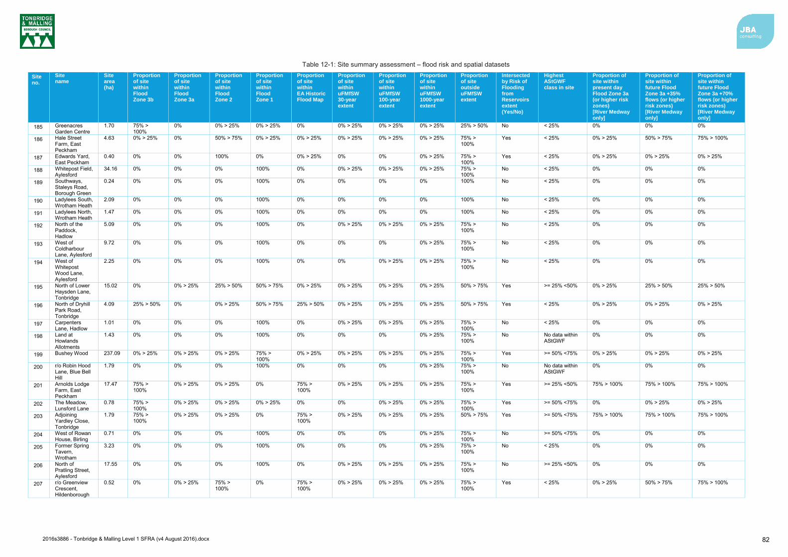
2016s3886 - Tonbridge & Malling Level 1 SFRA (v4 August 2016).docx 82
Table 12-1: Site summary assessment – flood risk and spatial datasets
Site no.
Site name
Site area (ha)
Proportion of site within Flood Zone 3b
Proportion of site within Flood Zone 3a
Proportion of site within Flood Zone 2
Proportion of site within Flood Zone 1
Proportion of site within EA Historic Flood Map
Proportion of site within uFMfSW 30-year extent
Proportion of site within uFMfSW 100-year extent
Proportion of site within uFMfSW 1000-year extent
Proportion of site outside uFMfSW extent
Intersected by Risk of Flooding from Reservoirs extent (Yes/No)
Highest AStGWF class in site
Proportion of site within present day Flood Zone 3a (or higher risk zones) [River Medway only]
Proportion of site within future Flood Zone 3a +35% flows (or higher risk zones) [River Medway only]
Proportion of site within future Flood Zone 3a +70% flows (or higher risk zones) [River Medway only]
185 Greenacres Garden Centre
1.70 75% > 100%
0% 0% > 25% 0% > 25% 0% 0% > 25% 0% > 25% 0% > 25% 25% > 50% No < 25% 0% 0% 0%
186 Hale Street Farm, East Peckham
4.63 0% > 25% 0% 50% > 75% 0% > 25% 0% > 25% 0% > 25% 0% > 25% 0% > 25% 75% > 100%
Yes < 25% 0% > 25% 50% > 75% 75% > 100%
187 Edwards Yard, East Peckham
0.40 0% 0% 100% 0% 0% > 25% 0% 0% 0% > 25% 75% > 100%
Yes < 25% 0% > 25% 0% > 25% 0% > 25%
188 Whitepost Field, Aylesford
34.16 0% 0% 0% 100% 0% 0% > 25% 0% > 25% 0% > 25% 75% > 100%
No < 25% 0% 0% 0%
189 Southways, Staleys Road, Borough Green
0.24 0% 0% 0% 100% 0% 0% 0% 0% 100% No < 25% 0% 0% 0%
190 Ladylees South, Wrotham Heath
2.09 0% 0% 0% 100% 0% 0% 0% 0% 100% No < 25% 0% 0% 0%
191 Ladylees North, Wrotham Heath
1.47 0% 0% 0% 100% 0% 0% 0% 0% 100% No < 25% 0% 0% 0%
192 North of the Paddock, Hadlow
5.09 0% 0% 0% 100% 0% 0% > 25% 0% > 25% 0% > 25% 75% > 100%
No < 25% 0% 0% 0%
193 West of Coldharbour Lane, Aylesford
9.72 0% 0% 0% 100% 0% 0% 0% 0% > 25% 75% > 100%
No < 25% 0% 0% 0%
194 West of Whitepost Wood Lane, Aylesford
2.25 0% 0% 0% 100% 0% 0% 0% > 25% 0% > 25% 75% > 100%
No < 25% 0% 0% 0%
195 North of Lower Haysden Lane, Tonbridge
15.02 0% 0% > 25% 25% > 50% 50% > 75% 0% > 25% 0% > 25% 0% > 25% 0% > 25% 50% > 75% Yes >= 25% <50% 0% > 25% 25% > 50% 25% > 50%
196 North of Dryhill Park Road, Tonbridge
4.09 25% > 50% 0% 0% > 25% 50% > 75% 25% > 50% 0% > 25% 0% > 25% 0% > 25% 50% > 75% Yes < 25% 0% > 25% 0% > 25% 0% > 25%
197 Carpenters Lane, Hadlow
1.01 0% 0% 0% 100% 0% 0% > 25% 0% > 25% 0% > 25% 75% > 100%
No < 25% 0% 0% 0%
198 Land at Howlands Allotments
1.43 0% 0% 0% 100% 0% 0% 0% 0% > 25% 75% > 100%
No No data within AStGWF
0% 0% 0%
199 Bushey Wood 237.09 0% > 25% 0% > 25% 0% > 25% 75% > 100%
0% > 25% 0% > 25% 0% > 25% 0% > 25% 75% > 100%
Yes >= 50% <75% 0% > 25% 0% > 25% 0% > 25%
200 r/o Robin Hood Lane, Blue Bell Hill
1.79 0% 0% 0% 100% 0% 0% 0% 0% > 25% 75% > 100%
No No data within AStGWF
0% 0% 0%
201 Arnolds Lodge Farm, East Peckham
17.47 75% > 100%
0% > 25% 0% > 25% 0% 75% > 100%
0% > 25% 0% > 25% 0% > 25% 75% > 100%
Yes >= 25% <50% 75% > 100% 75% > 100% 75% > 100%
202 The Meadow, Lunsford Lane
0.78 75% > 100%
0% > 25% 0% > 25% 0% > 25% 0% 0% 0% > 25% 0% > 25% 75% > 100%
Yes >= 50% <75% 0% 0% > 25% 0% > 25%
203 Adjoining Yardley Close, Tonbridge
1.79 75% > 100%
0% > 25% 0% > 25% 0% 75% > 100%
0% > 25% 0% > 25% 0% > 25% 50% > 75% Yes >= 50% <75% 75% > 100% 75% > 100% 75% > 100%
204 West of Rowan House, Birling
0.71 0% 0% 0% 100% 0% 0% 0% 0% > 25% 75% > 100%
No >= 50% <75% 0% 0% 0%
205 Former Spring Tavern, Wrotham
3.23 0% 0% 0% 100% 0% 0% 0% 0% > 25% 75% > 100%
No < 25% 0% 0% 0%
206 North of Pratling Street, Aylesford
17.55 0% 0% 0% 100% 0% 0% > 25% 0% > 25% 0% > 25% 75% > 100%
No >= 25% <50% 0% 0% 0%
207 r/o Greenview Crescent, Hildenborough
0.52 0% 0% > 25% 75% > 100%
0% 75% > 100%
0% > 25% 0% > 25% 0% > 25% 75% > 100%
Yes < 25% 0% > 25% 50% > 75% 75% > 100%
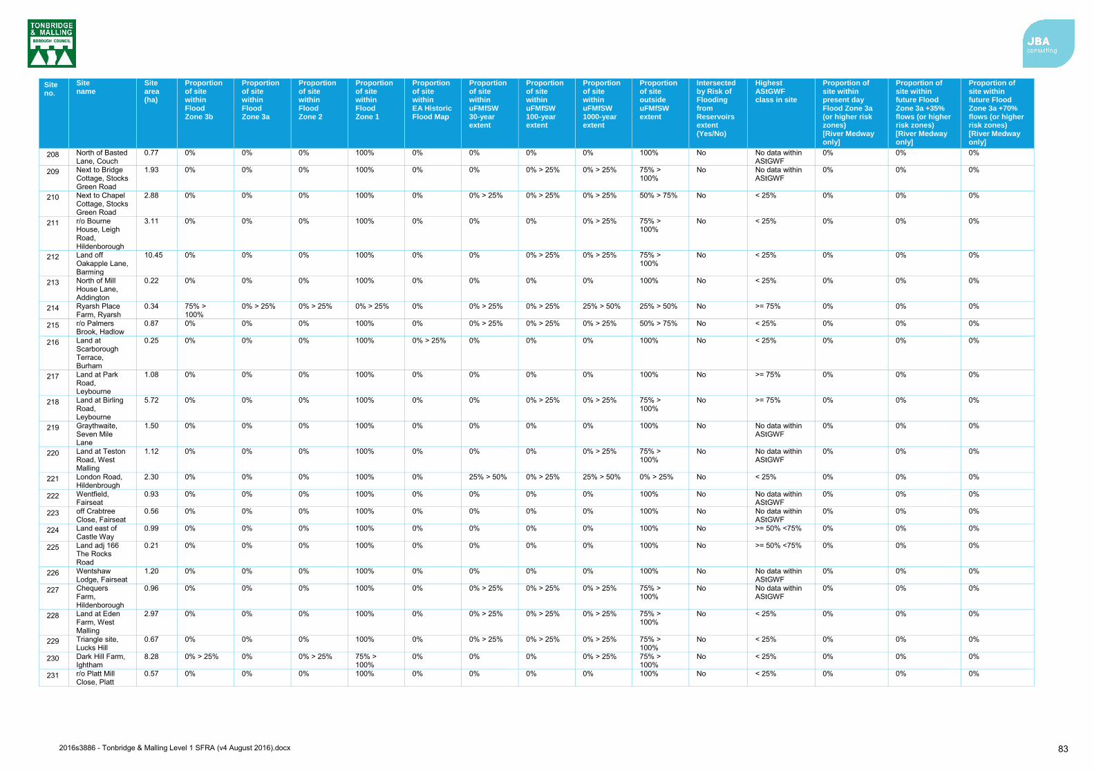
2016s3886 - Tonbridge & Malling Level 1 SFRA (v4 August 2016).docx 83
Site no.
Site name
Site area (ha)
Proportion of site within Flood Zone 3b
Proportion of site within Flood Zone 3a
Proportion of site within Flood Zone 2
Proportion of site within Flood Zone 1
Proportion of site within EA Historic Flood Map
Proportion of site within uFMfSW 30-year extent
Proportion of site within uFMfSW 100-year extent
Proportion of site within uFMfSW 1000-year extent
Proportion of site outside uFMfSW extent
Intersected by Risk of Flooding from Reservoirs extent (Yes/No)
Highest AStGWF class in site
Proportion of site within present day Flood Zone 3a (or higher risk zones) [River Medway only]
Proportion of site within future Flood Zone 3a +35% flows (or higher risk zones) [River Medway only]
Proportion of site within future Flood Zone 3a +70% flows (or higher risk zones) [River Medway only]
208 North of Basted Lane, Couch
0.77 0% 0% 0% 100% 0% 0% 0% 0% 100% No No data within AStGWF
0% 0% 0%
209 Next to Bridge Cottage, Stocks Green Road
1.93 0% 0% 0% 100% 0% 0% 0% > 25% 0% > 25% 75% > 100%
No No data within AStGWF
0% 0% 0%
210 Next to Chapel Cottage, Stocks Green Road
2.88 0% 0% 0% 100% 0% 0% > 25% 0% > 25% 0% > 25% 50% > 75% No < 25% 0% 0% 0%
211 r/o Bourne House, Leigh Road, Hildenborough
3.11 0% 0% 0% 100% 0% 0% 0% 0% > 25% 75% > 100%
No < 25% 0% 0% 0%
212 Land off Oakapple Lane, Barming
10.45 0% 0% 0% 100% 0% 0% 0% > 25% 0% > 25% 75% > 100%
No < 25% 0% 0% 0%
213 North of Mill House Lane, Addington
0.22 0% 0% 0% 100% 0% 0% 0% 0% 100% No < 25% 0% 0% 0%
214 Ryarsh Place Farm, Ryarsh
0.34 75% > 100%
0% > 25% 0% > 25% 0% > 25% 0% 0% > 25% 0% > 25% 25% > 50% 25% > 50% No >= 75% 0% 0% 0%
215 r/o Palmers Brook, Hadlow
0.87 0% 0% 0% 100% 0% 0% > 25% 0% > 25% 0% > 25% 50% > 75% No < 25% 0% 0% 0%
216 Land at Scarborough Terrace, Burham
0.25 0% 0% 0% 100% 0% > 25% 0% 0% 0% 100% No < 25% 0% 0% 0%
217 Land at Park Road, Leybourne
1.08 0% 0% 0% 100% 0% 0% 0% 0% 100% No >= 75% 0% 0% 0%
218 Land at Birling Road, Leybourne
5.72 0% 0% 0% 100% 0% 0% 0% > 25% 0% > 25% 75% > 100%
No >= 75% 0% 0% 0%
219 Graythwaite, Seven Mile Lane
1.50 0% 0% 0% 100% 0% 0% 0% 0% 100% No No data within AStGWF
0% 0% 0%
220 Land at Teston Road, West Malling
1.12 0% 0% 0% 100% 0% 0% 0% 0% > 25% 75% > 100%
No No data within AStGWF
0% 0% 0%
221 London Road, Hildenbrough
2.30 0% 0% 0% 100% 0% 25% > 50% 0% > 25% 25% > 50% 0% > 25% No < 25% 0% 0% 0%
222 Wentfield, Fairseat
0.93 0% 0% 0% 100% 0% 0% 0% 0% 100% No No data within AStGWF
0% 0% 0%
223 off Crabtree Close, Fairseat
0.56 0% 0% 0% 100% 0% 0% 0% 0% 100% No No data within AStGWF
0% 0% 0%
224 Land east of Castle Way
0.99 0% 0% 0% 100% 0% 0% 0% 0% 100% No >= 50% <75% 0% 0% 0%
225 Land adj 166 The Rocks Road
0.21 0% 0% 0% 100% 0% 0% 0% 0% 100% No >= 50% <75% 0% 0% 0%
226 Wentshaw Lodge, Fairseat
1.20 0% 0% 0% 100% 0% 0% 0% 0% 100% No No data within AStGWF
0% 0% 0%
227 Chequers Farm, Hildenborough
0.96 0% 0% 0% 100% 0% 0% > 25% 0% > 25% 0% > 25% 75% > 100%
No No data within AStGWF
0% 0% 0%
228 Land at Eden Farm, West Malling
2.97 0% 0% 0% 100% 0% 0% > 25% 0% > 25% 0% > 25% 75% > 100%
No < 25% 0% 0% 0%
229 Triangle site, Lucks Hill
0.67 0% 0% 0% 100% 0% 0% > 25% 0% > 25% 0% > 25% 75% > 100%
No < 25% 0% 0% 0%
230 Dark Hill Farm, Ightham
8.28 0% > 25% 0% 0% > 25% 75% > 100%
0% 0% 0% 0% > 25% 75% > 100%
No < 25% 0% 0% 0%
231 r/o Platt Mill Close, Platt
0.57 0% 0% 0% 100% 0% 0% 0% 0% 100% No < 25% 0% 0% 0%

2016s3886 - Tonbridge & Malling Level 1 SFRA (v4 August 2016).docx 84
Site no.
Site name
Site area (ha)
Proportion of site within Flood Zone 3b
Proportion of site within Flood Zone 3a
Proportion of site within Flood Zone 2
Proportion of site within Flood Zone 1
Proportion of site within EA Historic Flood Map
Proportion of site within uFMfSW 30-year extent
Proportion of site within uFMfSW 100-year extent
Proportion of site within uFMfSW 1000-year extent
Proportion of site outside uFMfSW extent
Intersected by Risk of Flooding from Reservoirs extent (Yes/No)
Highest AStGWF class in site
Proportion of site within present day Flood Zone 3a (or higher risk zones) [River Medway only]
Proportion of site within future Flood Zone 3a +35% flows (or higher risk zones) [River Medway only]
Proportion of site within future Flood Zone 3a +70% flows (or higher risk zones) [River Medway only]
232 Opposite 170 Offham Rd, West Malling
3.62 0% 0% 0% 100% 0% 0% 0% 0% > 25% 75% > 100%
No < 25% 0% 0% 0%
233 South of Church Lane, East Peckham
1.94 0% > 25% 0% 50% > 75% 25% > 50% 0% > 25% 0% > 25% 0% > 25% 0% > 25% 75% > 100%
Yes < 25% 0% > 25% 25% > 50% 75% > 100%
234 Fatherwell Road, West Malling
4.11 0% 0% 0% 100% 0% 0% 0% 0% > 25% 75% > 100%
No < 25% 0% 0% 0%
235 North of Maidstone Rd, Platt
1.28 0% 0% 0% 100% 0% 0% 0% 25% > 50% 50% > 75% No < 25% 0% 0% 0%
236 Land off Cobdown Close, Ditton
0.30 0% 0% 0% 100% 0% 0% 0% 0% 100% No < 25% 0% 0% 0%
237 Land at Stocks Green Road, Hildenborough
3.64 0% 0% 0% > 25% 75% > 100%
0% > 25% 0% > 25% 0% > 25% 0% > 25% 75% > 100%
No < 25% 0% 0% 0%
238 Westbrook Farm, East Malling
4.53 0% 0% 0% 100% 0% 0% 0% 0% > 25% 75% > 100%
No < 25% 0% 0% 0%
239 Land south of Hermitage Court, Hermitage Lane
1.39 0% 0% 0% 100% 0% 0% 0% 0% 100% No < 25% 0% 0% 0%
240 East of London Road, Wrotham
3.44 0% 0% 0% 100% 0% 0% 0% > 25% 25% > 50% 50% > 75% No < 25% 0% 0% 0%
241 East of Cobdown Close, Ditton
0.25 75% > 100%
0% 0% > 25% 0% > 25% 0% 0% 0% > 25% 25% > 50% 25% > 50% No < 25% 0% 0% 0%
242 North of London Road, Ditton
0.43 0% 0% 0% 100% 0% 0% 0% 0% 100% No < 25% 0% 0% 0%
243 Station Road, Ditton
0.42 50% > 75% 0% 0% > 25% 25% > 50% 0% 0% 25% > 50% 25% > 50% 0% > 25% No < 25% 0% 0% 0%
244 East of Riding Lane, Hildenborough
3.18 0% 0% 0% 100% 0% 25% > 50% 0% > 25% 25% > 50% 25% > 50% No < 25% 0% 0% 0%
245 Land at Snoll Hatch, East Peckham
5.63 0% > 25% 0% > 25% 50% > 75% 0% 0% > 25% 0% > 25% 0% > 25% 25% > 50% 50% > 75% Yes < 25% 0% > 25% 0% > 25% 50% > 75%
246 39 Bells Farm Road, East Peckham
1.36 0% 0% 0% 100% 0% 0% > 25% 0% > 25% 0% > 25% 75% > 100%
No < 25% 0% 0% 0%
247 Land at Tile Barn Corner, Tonbridge
0.66 0% 0% > 25% 0% > 25% 75% > 100%
0% > 25% 0% 0% 0% > 25% 75% > 100%
No >= 50% <75% 0% > 25% 0% > 25% 0% > 25%
248 Drayton Road Industrial Estate, Tonbridge
1.70 0% 0% 0% 100% 0% 0% > 25% 0% > 25% 0% > 25% 75% > 100%
No < 25% 0% 0% 0%
249 Hut Field, The Street, Mereworth
1.06 0% 0% 0% 100% 0% 0% 0% 0% 100% No No data within AStGWF
0% 0% 0%
250 Nettle Bank, Postern Lane, Tonbridge
0.42 0% > 25% 0% 0% > 25% 75% > 100%
0% > 25% 0% 0% 0% 100% No >= 25% <50% 0% > 25% 0% > 25% 0% > 25%
251 Land off Court Lane, Hadlow
2.62 0% 0% 0% 100% 0% 0% 0% 0% 100% No < 25% 0% 0% 0%
252 Webbs Field, Station Road, Ditton
3.10 75% > 100%
0% 0% > 25% 0% > 25% 0% 0% > 25% 75% > 100%
0% > 25% 0% > 25% No < 25% 0% 0% 0%

2016s3886 - Tonbridge & Malling Level 1 SFRA (v4 August 2016).docx 85
Site no.
Site name
Site area (ha)
Proportion of site within Flood Zone 3b
Proportion of site within Flood Zone 3a
Proportion of site within Flood Zone 2
Proportion of site within Flood Zone 1
Proportion of site within EA Historic Flood Map
Proportion of site within uFMfSW 30-year extent
Proportion of site within uFMfSW 100-year extent
Proportion of site within uFMfSW 1000-year extent
Proportion of site outside uFMfSW extent
Intersected by Risk of Flooding from Reservoirs extent (Yes/No)
Highest AStGWF class in site
Proportion of site within present day Flood Zone 3a (or higher risk zones) [River Medway only]
Proportion of site within future Flood Zone 3a +35% flows (or higher risk zones) [River Medway only]
Proportion of site within future Flood Zone 3a +70% flows (or higher risk zones) [River Medway only]
253 Land at South Lodge, East Malling
1.47 0% 0% 0% 100% 0% 0% 0% 0% 100% No No data within AStGWF
0% 0% 0%
254 North of The Paddock, Hadlow
5.26 0% 0% 0% 100% 0% 0% > 25% 0% > 25% 0% > 25% 75% > 100%
No < 25% 0% 0% 0%
255 Rosador, London Road, Wrotham
0.70 0% 0% 0% 100% 0% 0% 0% > 25% 25% > 50% 50% > 75% No < 25% 0% 0% 0%
256 Dark Hill Farm, Borough Green
12.30 0% > 25% 0% 0% > 25% 75% > 100%
0% 0% > 25% 0% > 25% 0% > 25% 75% > 100%
No < 25% 0% 0% 0%
257 West of Hermitage Lane
2.31 0% 0% 0% 100% 0% 0% 0% 0% > 25% 75% > 100%
No < 25% 0% 0% 0%
258 Green Lane, Trottiscliffe
1.23 0% 0% 0% 100% 0% 0% 0% 0% > 25% 75% > 100%
No >= 25% <50% 0% 0% 0%
259 Munday Works, Tonbridge
1.70 0% > 25% 75% > 100%
0% 0% 75% > 100%
0% 0% > 25% 0% > 25% 75% > 100%
Yes >= 50% <75% 100% 100% 100%
260 Three Elm Lane, Golden Green
0.25 0% 0% 0% 100% 0% 0% 0% 0% > 25% 75% > 100%
No < 25% 0% 0% 0%
261 Reed House Paddock, Plaxtol
0.11 0% 0% 0% 100% 0% 0% 0% 0% > 25% 75% > 100%
No No data within AStGWF
0% 0% 0%
262 Detling Field, Hermitage Lane, Aylesford
14.36 0% 0% 0% 100% 0% 0% > 25% 0% > 25% 0% > 25% 75% > 100%
No < 25% 0% 0% 0%
263 The Freehold, Hadlow
0.08 0% 0% 0% 100% 0% 0% > 25% 0% > 25% 25% > 50% 25% > 50% No >= 25% <50% 0% 0% 0%
264 Court Lane Nurseries, Hadlow
1.46 0% 0% 0% 100% 0% 0% 0% 0% 100% No < 25% 0% 0% 0%
265 Lavenders Road, West Malling
1.02 0% 0% 0% 100% 0% 0% 0% 0% > 25% 75% > 100%
No < 25% 0% 0% 0%
266 Fishponds Farm, Lower Haysden Lane, Tonbridge
4.53 0% 0% 0% 100% 0% 0% > 25% 0% > 25% 0% > 25% 75% > 100%
No >= 25% <50% 0% 0% 0%
267 Branbridges Wharf, East Peckham
0.99 0% > 25% 75% > 100%
0% 0% 75% > 100%
0% 0% > 25% 0% > 25% 75% > 100%
Yes >= 25% <50% 75% > 100% 75% > 100% 75% > 100%
268 Hermitage Farm, Winterfield Lane, East Malling
4.16 0% 0% 0% 100% 0% 0% > 25% 0% > 25% 0% > 25% 75% > 100%
No < 25% 0% 0% 0%
269 Bull Lane, Eccles
0.29 0% 0% 0% 100% 0% 0% 0% 0% 100% No >= 25% <50% 0% 0% 0%
270 Bell Lane, Burham
5.73 0% 0% 0% 100% 0% 0% 0% > 25% 0% > 25% 75% > 100%
No >= 50% <75% 0% 0% 0%
271 Peters Village, North Extension
0.77 0% 0% 0% 100% 0% 0% 0% 0% 100% No >= 50% <75% 0% 0% 0%
272 Peters Village, South Extension
3.33 25% > 50% 0% > 25% 0% > 25% 25% > 50% 0% > 25% 0% 0% 0% > 25% 75% > 100%
Yes >= 25% <50% 50% > 75% 50% > 75% 50% > 75%
273 Wouldham Allotments
4.45 0% 0% 0% 100% 0% 0% 0% 0% 100% No >= 50% <75% 0% 0% 0%
274 North of Postern Lane, Tonbridge
7.06 75% > 100%
0% > 25% 0% 0% 75% > 100%
0% > 25% 0% > 25% 25% > 50% 50% > 75% Yes >= 25% <50% 100% 100% 100%
275 Grange Farm, Tonbridge
42.62 0% > 25% 0% 0% 75% > 100%
0% 0% > 25% 0% > 25% 0% > 25% 75% > 100%
No < 25% 0% 0% 0%

2016s3886 - Tonbridge & Malling Level 1 SFRA (v4 August 2016).docx 86
Site no.
Site name
Site area (ha)
Proportion of site within Flood Zone 3b
Proportion of site within Flood Zone 3a
Proportion of site within Flood Zone 2
Proportion of site within Flood Zone 1
Proportion of site within EA Historic Flood Map
Proportion of site within uFMfSW 30-year extent
Proportion of site within uFMfSW 100-year extent
Proportion of site within uFMfSW 1000-year extent
Proportion of site outside uFMfSW extent
Intersected by Risk of Flooding from Reservoirs extent (Yes/No)
Highest AStGWF class in site
Proportion of site within present day Flood Zone 3a (or higher risk zones) [River Medway only]
Proportion of site within future Flood Zone 3a +35% flows (or higher risk zones) [River Medway only]
Proportion of site within future Flood Zone 3a +70% flows (or higher risk zones) [River Medway only]
276 Greentrees Farm, Tonbridge
15.47 0% 0% 0% 100% 0% 0% > 25% 0% > 25% 0% > 25% 75% > 100%
No < 25% 0% 0% 0%
277 Clare Park, east of Winterfield Lane, East Malling
2.87 0% 0% 0% 100% 0% 0% 0% 0% 100% No < 25% 0% 0% 0%
278 Aylesford Quarry, Aylesford
98.31 0% 0% 0% > 25% 75% > 100%
0% > 25% 0% > 25% 0% > 25% 0% > 25% 75% > 100%
Yes >= 25% <50% 0% > 25% 0% > 25% 0% > 25%
279 Stan Lane, West Peckham
3.97 0% 0% 0% 100% 0% 0% 0% > 25% 0% > 25% 75% > 100%
No No data within AStGWF
0% 0% 0%
280 Little Postern, Postern Lane, Tonbridge
10.84 0% > 25% 0% 0% > 25% 75% > 100%
0% > 25% 0% > 25% 0% > 25% 0% > 25% 75% > 100%
No < 25% 0% 0% 0%
281 Paris Farm, Rocks Road, East Malling
4.23 0% 0% 0% 100% 0% 0% > 25% 0% > 25% 0% > 25% 75% > 100%
No >= 50% <75% 0% 0% 0%
282 North of Norman Road, West Malling
2.10 0% 0% 0% 100% 0% 0% 0% > 25% 25% > 50% 50% > 75% No >= 75% 0% 0% 0%
283 North of Tolsey Mead, Borough Green
2.45 0% 0% 0% 100% 0% 0% > 25% 0% > 25% 25% > 50% 50% > 75% No < 25% 0% 0% 0%
284 Roughway Mill, Dunks Green
3.26 0% > 25% 0% 0% > 25% 50% > 75% 25% > 50% 0% > 25% 0% > 25% 0% > 25% 50% > 75% No < 25% 0% 0% 0%
285 London Road, Wrotham Heath
0.47 0% 0% 0% 100% 0% 0% 0% 0% > 25% 75% > 100%
No < 25% 0% 0% 0%
286 Trosley Farm, Addington Lane, Trottiscliffe
4.22 0% 0% 0% 100% 0% > 25% 0% 0% > 25% 75% > 100%
0% > 25% No < 25% 0% 0% 0%
287 Bull Road, Birling (Option A)
0.41 0% 0% 0% 100% 0% 0% > 25% 0% > 25% 0% > 25% 75% > 100%
No >= 75% 0% 0% 0%
288 Bull Road Birling (Option B)
3.04 0% 0% 0% 100% 0% 0% > 25% 0% > 25% 0% > 25% 75% > 100%
No >= 75% 0% 0% 0%
289 Ryarsh Road, Birling
0.60 0% 0% 0% 100% 0% 0% 0% 0% > 25% 75% > 100%
No >= 50% <75% 0% 0% 0%
290 Chapel Street, Ryarsh
0.57 0% 0% 0% 100% 0% 0% 0% > 25% 0% > 25% 75% > 100%
No >= 25% <50% 0% 0% 0%
291 Woodgate Road, Ryarsh
1.21 0% 0% 0% 100% 0% 0% > 25% 0% > 25% 0% > 25% 50% > 75% No >= 50% <75% 0% 0% 0%
292 Pinesfield Lane, Trottiscliffe
0.61 0% 0% 0% 100% 0% 0% 0% 0% > 25% 75% > 100%
No >= 25% <50% 0% 0% 0%
293 adj The Chestnuts, Addington
0.23 0% 0% 0% 100% 0% 0% 0% 0% 100% No < 25% 0% 0% 0%
294 Land off Hermitage Lane
1.88 0% 0% 0% 100% 0% 0% 0% 0% > 25% 75% > 100%
No < 25% 0% 0% 0%
295 adj Callis Court Bungalow. London Road, Ryarsh
0.77 0% 0% 0% 100% 0% 0% 0% 0% 100% No >= 75% 0% 0% 0%
296 Dark Hill / Gracelands Park, Ightham
8.26 0% > 25% 0% 0% > 25% 75% > 100%
0% 0% 0% 0% > 25% 75% > 100%
No < 25% 0% 0% 0%
297 Former Upper Bell Car Park, Blue Bell Hill
0.19 0% 0% 0% 100% 0% 0% 0% 0% 100% No No data within AStGWF
0% 0% 0%

2016s3886 - Tonbridge & Malling Level 1 SFRA (v4 August 2016).docx 87
Site no.
Site name
Site area (ha)
Proportion of site within Flood Zone 3b
Proportion of site within Flood Zone 3a
Proportion of site within Flood Zone 2
Proportion of site within Flood Zone 1
Proportion of site within EA Historic Flood Map
Proportion of site within uFMfSW 30-year extent
Proportion of site within uFMfSW 100-year extent
Proportion of site within uFMfSW 1000-year extent
Proportion of site outside uFMfSW extent
Intersected by Risk of Flooding from Reservoirs extent (Yes/No)
Highest AStGWF class in site
Proportion of site within present day Flood Zone 3a (or higher risk zones) [River Medway only]
Proportion of site within future Flood Zone 3a +35% flows (or higher risk zones) [River Medway only]
Proportion of site within future Flood Zone 3a +70% flows (or higher risk zones) [River Medway only]
298 South of Rectory Lane, Ightham
1.91 0% 0% 0% 100% 0% 0% > 25% 0% > 25% 0% > 25% 75% > 100%
No < 25% 0% 0% 0%
299 East of Offham Road, West Malling
2.70 0% 0% 0% 100% 0% 0% > 25% 0% > 25% 0% > 25% 75% > 100%
No < 25% 0% 0% 0%
300 Crouch Lane, Borough Green
3.19 0% 0% 0% 100% 0% 0% 0% 0% 100% No < 25% 0% 0% 0%
301 Opposite Pine View, Platt
0.66 0% 0% 0% 100% 0% 0% 0% 0% 100% No < 25% 0% 0% 0%
302 Globlands Farm, Court Lane, Hadlow
5.60 0% 0% 0% 100% 0% 0% > 25% 0% > 25% 0% > 25% 75% > 100%
No < 25% 0% 0% 0%
303 off Fields Lane, Wateringbury
4.61 0% 0% 0% 100% 0% 0% 0% 0% 100% No >= 75% 0% 0% 0%
304 East Malling Research Station
192.10 0% > 25% 0% 0% > 25% 75% > 100%
0% 0% > 25% 0% > 25% 0% > 25% 75% > 100%
No < 25% 0% 0% 0%
305 Ashes Lane, Pittswood
0.82 0% 0% 0% 100% 0% 0% > 25% 0% > 25% 0% > 25% 75% > 100%
No < 25% 0% 0% 0%
306 South of Chapel Street, Ryarsh
0.17 0% 0% 0% 100% 0% 0% 0% 0% > 25% 75% > 100%
No >= 25% <50% 0% 0% 0%
307 West of Chapel Street, Ryarsh
0.87 0% 0% 0% 100% 0% 0% 0% > 25% 0% > 25% 75% > 100%
No >= 25% <50% 0% 0% 0%
308 The Harrow PH, Maidstone Road, Hadlow
0.30 0% 0% 0% 100% 0% 25% > 50% 0% > 25% 25% > 50% 25% > 50% No < 25% 0% 0% 0%
309 Office site, Quarry Hill Rd, Borough Green
0.28 25% > 50% 0% 50% > 75% 0% > 25% 0% 0% > 25% 0% > 25% 25% > 50% 50% > 75% No < 25% 0% 0% 0%
310 Barfield House, Teston Rd, Offham
0.74 0% 0% 0% 100% 0% 0% 0% 0% > 25% 75% > 100%
No < 25% 0% 0% 0%
311 North of Fairfield Rd, Borough Green
0.51 0% 0% 0% 100% 0% 0% > 25% 0% > 25% 0% > 25% 75% > 100%
No < 25% 0% 0% 0%
312 West of Wrotham Road, Borough Green
3.56 0% 0% 0% 100% 0% 0% > 25% 0% > 25% 0% > 25% 75% > 100%
No < 25% 0% 0% 0%
313 A-Z Geographers, Fairfield Rd, Borough Green
1.01 0% 0% 0% 100% 0% 0% 0% 0% > 25% 75% > 100%
No < 25% 0% 0% 0%
314 Rochester Road, Borstal
3.76 0% 0% 0% 100% 0% 0% > 25% 0% > 25% 0% > 25% 75% > 100%
No No data within AStGWF
0% 0% 0%
315 Potters Mead, Wrotham Rd, Borough Green
0.35 0% 0% 0% 100% 0% 0% > 25% 0% > 25% 0% > 25% 50% > 75% No < 25% 0% 0% 0%
316 off Drylands Road, Borough Green
7.83 0% > 25% 0% 0% 75% > 100%
0% 0% > 25% 0% > 25% 0% > 25% 75% > 100%
No < 25% 0% 0% 0%
317 Bells Wood Yard, Kings Hill
5.91 0% 0% 0% 100% 0% 0% 0% 0% > 25% 75% > 100%
No < 25% 0% 0% 0%
318 East of The Orpines, Wateringbury
2.36 0% 0% 0% 100% 0% 0% 0% 0% 100% No >= 75% 0% 0% 0%
319 The Street, Mereworth
2.16 0% 0% 0% 100% 0% 0% 0% 0% 100% No No data within AStGWF
0% 0% 0%
320 Brewers Hall Farm, Mereworth
2.31 0% 0% 0% 100% 0% 0% > 25% 0% > 25% 0% > 25% 75% > 100%
No No data within AStGWF
0% 0% 0%
321 Pinkham, East Peckham
2.67 100% 0% 0% 0% 75% > 100%
0% > 25% 0% > 25% 25% > 50% 50% > 75% Yes < 25% 100% 100% 100%

2016s3886 - Tonbridge & Malling Level 1 SFRA (v4 August 2016).docx 88
Site no.
Site name
Site area (ha)
Proportion of site within Flood Zone 3b
Proportion of site within Flood Zone 3a
Proportion of site within Flood Zone 2
Proportion of site within Flood Zone 1
Proportion of site within EA Historic Flood Map
Proportion of site within uFMfSW 30-year extent
Proportion of site within uFMfSW 100-year extent
Proportion of site within uFMfSW 1000-year extent
Proportion of site outside uFMfSW extent
Intersected by Risk of Flooding from Reservoirs extent (Yes/No)
Highest AStGWF class in site
Proportion of site within present day Flood Zone 3a (or higher risk zones) [River Medway only]
Proportion of site within future Flood Zone 3a +35% flows (or higher risk zones) [River Medway only]
Proportion of site within future Flood Zone 3a +70% flows (or higher risk zones) [River Medway only]
322 Mackenders Lane, Eccles
2.83 0% 0% 0% 100% 0% 0% 0% 0% > 25% 75% > 100%
No < 25% 0% 0% 0%
323 East of Church Road, Offham
1.94 0% 0% 0% 100% 0% 0% > 25% 0% > 25% 0% > 25% 75% > 100%
No < 25% 0% 0% 0%
324 West of Church Road, Offham
5.83 0% 0% 0% 100% 0% 0% > 25% 0% > 25% 0% > 25% 75% > 100%
No < 25% 0% 0% 0%
325 West of Fatherwell Avenue, West Malling
8.20 0% 0% 0% 100% 0% 0% > 25% 0% > 25% 0% > 25% 75% > 100%
No < 25% 0% 0% 0%
326 North of Offham Road, West Malling
7.72 0% 0% 0% 100% 0% 0% > 25% 0% > 25% 0% > 25% 75% > 100%
No < 25% 0% 0% 0%
327 West of West Malling
14.14 0% 0% 0% 100% 0% 0% > 25% 0% > 25% 0% > 25% 75% > 100%
No < 25% 0% 0% 0%
328 South of Birchin Napps Farm
1.09 0% 0% 0% 100% 0% 0% 0% 0% 100% No No data within AStGWF
0% 0% 0%
329 South Hurst Wood
2.13 0% 0% 0% 100% 0% 0% 0% 0% 100% No < 25% 0% 0% 0%
330 Roughways Barn
0.95 0% 0% 0% 100% 0% 0% 0% 0% 100% No < 25% 0% 0% 0%
331 Yopps Green 0.73 0% 0% 0% 100% 0% 0% 0% 0% 100% No < 25% 0% 0% 0%
332 North of Woodgate Way, Tonbridge
1.41 25% > 50% 0% 0% > 25% 25% > 50% 0% 0% > 25% 0% > 25% 25% > 50% 25% > 50% No < 25% 0% 0% 0%
333 Plaxtol Allotments
1.67 0% 0% 0% 100% 0% 0% 0% 0% 100% No No data within AStGWF
0% 0% 0%
334 South of Vauxhall Gardens. Tonbridge
2.03 0% 0% 0% 100% 0% 0% 0% > 25% 0% > 25% 75% > 100%
No < 25% 0% 0% 0%
335 A21 Vauxhall intersection, Tonbridge
0.40 0% 0% 0% 100% 0% 0% > 25% 0% > 25% 0% > 25% 75% > 100%
No < 25% 0% 0% 0%
336 Broadfield 1.53 0% 0% 0% 100% 0% 0% 0% 0% 100% No < 25% 0% 0% 0%
337 South of Golden Green
1.85 0% 0% 0% 100% 0% 0% 0% 0% > 25% 75% > 100%
No < 25% 0% 0% 0%
338 West of Dunks Green
2.77 0% 0% 0% 100% 0% 0% > 25% 0% > 25% 0% > 25% 75% > 100%
No < 25% 0% 0% 0%
339 St Mary's Road, Wrotham
1.50 0% 0% 0% 100% 0% 0% 0% > 25% 0% > 25% 75% > 100%
No < 25% 0% 0% 0%
340 Puttenden Road, Dunks Green
0.39 0% 0% 0% 100% 0% 0% 0% 0% > 25% 75% > 100%
No < 25% 0% 0% 0%
341 Point Corner 1.74 0% 0% 0% 100% 0% 0% 0% 0% > 25% 75% > 100%
No < 25% 0% 0% 0%
342 East Upper Green Lane
1.97 0% 0% 0% 100% 0% 0% 0% > 25% 0% > 25% 75% > 100%
No < 25% 0% 0% 0%
343 Five Acre Field 2.14 0% 0% 0% 100% 0% 0% 0% 0% > 25% 75% > 100%
No < 25% 0% 0% 0%
344 South Ambleside
3.45 0% > 25% 0% 0% > 25% 75% > 100%
0% 0% > 25% 0% > 25% 25% > 50% 50% > 75% No < 25% 0% 0% 0%
345 23 Tulip Tree Close, Tonbridge
0.11 0% 0% 0% 100% 0% 0% 0% 0% 100% No < 25% 0% 0% 0%
346 North of Barchester Way
14.49 0% 0% 0% 100% 0% 0% > 25% 0% > 25% 0% > 25% 75% > 100%
No < 25% 0% 0% 0%
347 School Field, Back Lane
2.05 0% 0% 0% 100% 0% 0% > 25% 0% > 25% 0% > 25% 50% > 75% No < 25% 0% 0% 0%
348 Callis Wood 2.32 0% 0% 0% 100% 0% 0% > 25% 0% > 25% 0% > 25% 75% > 100%
No No data within AStGWF
0% 0% 0%
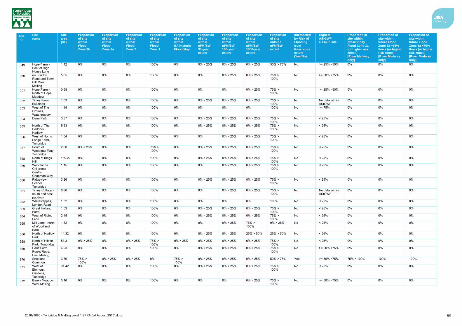
2016s3886 - Tonbridge & Malling Level 1 SFRA (v4 August 2016).docx 89
Site no.
Site name
Site area (ha)
Proportion of site within Flood Zone 3b
Proportion of site within Flood Zone 3a
Proportion of site within Flood Zone 2
Proportion of site within Flood Zone 1
Proportion of site within EA Historic Flood Map
Proportion of site within uFMfSW 30-year extent
Proportion of site within uFMfSW 100-year extent
Proportion of site within uFMfSW 1000-year extent
Proportion of site outside uFMfSW extent
Intersected by Risk of Flooding from Reservoirs extent (Yes/No)
Highest AStGWF class in site
Proportion of site within present day Flood Zone 3a (or higher risk zones) [River Medway only]
Proportion of site within future Flood Zone 3a +35% flows (or higher risk zones) [River Medway only]
Proportion of site within future Flood Zone 3a +70% flows (or higher risk zones) [River Medway only]
349 Hope Farm - East of High House Lane
1.12 0% 0% 0% 100% 0% 0% > 25% 0% > 25% 0% > 25% 50% > 75% No >= 25% <50% 0% 0% 0%
350 r/o London Road and Town Hill, West Malling
5.05 0% 0% 0% 100% 0% 0% 0% > 25% 0% > 25% 75% > 100%
No >= 50% <75% 0% 0% 0%
351 Hope Farm - North of Hope Meadow
0.68 0% 0% 0% 100% 0% 0% 0% 0% > 25% 75% > 100%
No >= 25% <50% 0% 0% 0%
352 Tinley Farm Buildings
1.63 0% 0% 0% 100% 0% 0% > 25% 0% > 25% 0% > 25% 75% > 100%
No No data within AStGWF
0% 0% 0%
353 West of The Orpines, Wateringbury
1.19 0% 0% 0% 100% 0% 0% 0% 0% 100% No >= 75% 0% 0% 0%
354 Dene Park 3.37 0% 0% 0% 100% 0% 0% > 25% 0% > 25% 0% > 25% 75% > 100%
No < 25% 0% 0% 0%
355 North of The Paddock, Hadlow
5.23 0% 0% 0% 100% 0% 0% > 25% 0% > 25% 0% > 25% 75% > 100%
No < 25% 0% 0% 0%
356 West of Horns Lodge Farm, Tonbridge
1.64 0% 0% 0% 100% 0% 0% 0% > 25% 0% > 25% 75% > 100%
No < 25% 0% 0% 0%
357 South of Woodgate Way, Tonbridge
2.60 0% > 25% 0% 0% 75% > 100%
0% 0% > 25% 0% > 25% 0% > 25% 75% > 100%
No < 25% 0% 0% 0%
358 North of Kings Hill
169.22 0% 0% 0% 100% 0% 0% > 25% 0% > 25% 0% > 25% 75% > 100%
No < 25% 0% 0% 0%
359 Woodlands Children's Centre, Chapman Way
1.15 0% 0% 0% 100% 0% 0% 0% > 25% 0% > 25% 75% > 100%
No < 25% 0% 0% 0%
360 Ridgeview School, Tonbridge
3.26 0% 0% 0% 100% 0% 0% > 25% 0% > 25% 0% > 25% 75% > 100%
No < 25% 0% 0% 0%
361 Tinley Cottage - south and east paddock
0.80 0% 0% 0% 100% 0% 0% 0% > 25% 0% > 25% 75% > 100%
No No data within AStGWF
0% 0% 0%
362 Whitesteppes, London Road
1.32 0% 0% 0% 100% 0% 0% 0% 0% 100% No < 25% 0% 0% 0%
363 Great Holland Farm
1.53 0% 0% 0% 100% 0% 0% > 25% 0% > 25% 0% > 25% 75% > 100%
No < 25% 0% 0% 0%
364 West of Riding Lane
2.45 0% 0% 0% 100% 0% 0% > 25% 0% > 25% 0% > 25% 75% > 100%
No < 25% 0% 0% 0%
365 Mill Lane - north of Woodland Barn
1.32 0% 0% 0% 100% 0% 0% 0% > 25% 75% > 100%
0% > 25% No < 25% 0% 0% 0%
366 North of Hadlow Park
14.32 0% 0% 0% 100% 0% 0% > 25% 0% > 25% 25% > 50% 25% > 50% No < 25% 0% 0% 0%
368 North of Hilden Park, Tonbridge
51.31 0% > 25% 0% 0% > 25% 75% > 100%
0% > 25% 0% > 25% 0% > 25% 0% > 25% 75% > 100%
No < 25% 0% 0% 0%
369 Paris Farm, Rocks Road, East Malling
4.23 0% 0% 0% 100% 0% 0% > 25% 0% > 25% 0% > 25% 75% > 100%
No >= 50% <75% 0% 0% 0%
370 Snodland Common
3.79 75% > 100%
0% > 25% 0% > 25% 0% 75% > 100%
0% > 25% 0% > 25% 0% > 25% 50% > 75% Yes >= 50% <75% 75% > 100% 100% 100%
371 West of Elmhurst Gardens, Tonbridge
31.42 0% 0% 0% 100% 0% 0% > 25% 0% > 25% 0% > 25% 75% > 100%
No < 25% 0% 0% 0%
372 Banky Meadow, West Malling
3.16 0% 0% 0% 100% 0% 0% 0% 0% > 25% 75% > 100%
No >= 50% <75% 0% 0% 0%

2016s3886 - Tonbridge & Malling Level 1 SFRA (v4 August 2016).docx 90
Site no.
Site name
Site area (ha)
Proportion of site within Flood Zone 3b
Proportion of site within Flood Zone 3a
Proportion of site within Flood Zone 2
Proportion of site within Flood Zone 1
Proportion of site within EA Historic Flood Map
Proportion of site within uFMfSW 30-year extent
Proportion of site within uFMfSW 100-year extent
Proportion of site within uFMfSW 1000-year extent
Proportion of site outside uFMfSW extent
Intersected by Risk of Flooding from Reservoirs extent (Yes/No)
Highest AStGWF class in site
Proportion of site within present day Flood Zone 3a (or higher risk zones) [River Medway only]
Proportion of site within future Flood Zone 3a +35% flows (or higher risk zones) [River Medway only]
Proportion of site within future Flood Zone 3a +70% flows (or higher risk zones) [River Medway only]
373 South of London Road, Wrotham Heath
0.53 0% 0% 0% 100% 0% 0% 0% 0% 100% No >= 50% <75% 0% 0% 0%
374 Land at Wrotham Hill Road
41.33 0% 0% 0% 100% 0% 0% > 25% 0% > 25% 0% > 25% 75% > 100%
No < 25% 0% 0% 0%
375 The Warren, Trottiscliffe Road, Addington
0.97 0% 0% 0% 100% 0% 0% 0% 0% > 25% 75% > 100%
No >= 25% <50% 0% 0% 0%
376 Red House Cottage, Old Road, Wateringbury
0.59 0% > 25% 0% 0% > 25% 75% > 100%
0% 0% > 25% 0% > 25% 25% > 50% 50% > 75% Yes >= 25% <50% 0% 0% 0%
377 Joco Pit East, Borough Green
2.42 0% 0% 0% 100% 0% 0% > 25% 0% > 25% 0% > 25% 50% > 75% No < 25% 0% 0% 0%
378 Appledene Farm, Norman Road, West Malling
0.67 0% 0% 0% 100% 0% 0% 0% 0% > 25% 75% > 100%
No >= 75% 0% 0% 0%
379 opposite the Village Hall, Norman Road, West Malling
2.24 0% 0% 0% 100% 0% 0% 0% > 25% 0% > 25% 75% > 100%
No >= 75% 0% 0% 0%
380 West of Castle Way, Leybourne
6.87 0% 0% 0% 100% 0% 0% > 25% 0% > 25% 0% > 25% 75% > 100%
No >= 75% 0% 0% 0%
381 Bunyards Farm, Allington
19.22 0% 0% 0% 100% 0% 0% > 25% 0% > 25% 0% > 25% 75% > 100%
No < 25% 0% 0% 0%
382 Noble Tree End, Philpots Lane, Hildenborough
1.93 0% 0% 0% 100% 0% 0% 0% 0% > 25% 75% > 100%
No < 25% 0% 0% 0%
383 Plasterite, Redwell Lane, Ightham
0.21 0% 0% 0% 100% 0% 0% 0% > 25% 25% > 50% 50% > 75% No < 25% 0% 0% 0%
384 The Paddock, Common Road, Ightham
1.13 0% 0% 0% 100% 0% 0% > 25% 0% > 25% 0% > 25% 50% > 75% No < 25% 0% 0% 0%
385 Depot, Upper Haysden Lane, Tonbridge
1.10 0% 0% 0% 100% 0% 0% > 25% 0% > 25% 0% > 25% 75% > 100%
No >= 25% <50% 0% 0% 0%
386 North of The Paddock, Hadlow
5.24 0% 0% 0% 100% 0% 0% > 25% 0% > 25% 0% > 25% 75% > 100%
No < 25% 0% 0% 0%
387 adjacent Larkfield Library
0.28 0% 0% 0% 100% 0% 0% 0% 0% > 25% 75% > 100%
No < 25% 0% 0% 0%
388 Goose Green Farm, Hadlow
1.19 0% 0% 0% 100% 0% 0% 0% 0% > 25% 75% > 100%
No < 25% 0% 0% 0%
389 North of M20 Junction 5, Coldharbour Lane
7.73 0% 0% 0% 100% 0% 0% 0% > 25% 0% > 25% 75% > 100%
No >= 25% <50% 0% 0% 0%
390 Winterfield House, Larkfield
0.20 0% 0% 0% 100% 0% 0% > 25% 0% > 25% 0% > 25% 50% > 75% No >= 25% <50% 0% 0% 0%
391 East of Aylesford Priory
0.71 0% 0% 0% 100% 0% 0% 0% > 25% 0% > 25% 75% > 100%
No >= 25% <50% 0% 0% 0%
392 Barming Depot, Hermitage Lane
4.22 0% 0% 0% 100% 0% 0% > 25% 0% > 25% 0% > 25% 75% > 100%
No < 25% 0% 0% 0%
393 Manor Farm, Upper Haysden Lane
11.05 0% 0% 0% > 25% 75% > 100%
0% > 25% 0% > 25% 0% > 25% 0% > 25% 50% > 75% Yes >= 25% <50% 0% 0% > 25% 0% > 25%

2016s3886 - Tonbridge & Malling Level 1 SFRA (v4 August 2016).docx 91
Site no.
Site name
Site area (ha)
Proportion of site within Flood Zone 3b
Proportion of site within Flood Zone 3a
Proportion of site within Flood Zone 2
Proportion of site within Flood Zone 1
Proportion of site within EA Historic Flood Map
Proportion of site within uFMfSW 30-year extent
Proportion of site within uFMfSW 100-year extent
Proportion of site within uFMfSW 1000-year extent
Proportion of site outside uFMfSW extent
Intersected by Risk of Flooding from Reservoirs extent (Yes/No)
Highest AStGWF class in site
Proportion of site within present day Flood Zone 3a (or higher risk zones) [River Medway only]
Proportion of site within future Flood Zone 3a +35% flows (or higher risk zones) [River Medway only]
Proportion of site within future Flood Zone 3a +70% flows (or higher risk zones) [River Medway only]
394 Ingleborough Lane, Platt
2.22 0% 0% 0% 100% 0% 0% > 25% 0% > 25% 0% > 25% 75% > 100%
No < 25% 0% 0% 0%
395 Land West of Hale Street
4.85 0% > 25% 0% 50% > 75% 0% > 25% 0% > 25% 0% > 25% 0% > 25% 0% > 25% 75% > 100%
Yes < 25% 0% > 25% 25% > 50% 75% > 100%
396 r/o London Road, West Malling
3.64 0% 0% 0% 100% 0% 0% 0% > 25% 0% > 25% 75% > 100%
No >= 50% <75% 0% 0% 0%
397 Land at Former Priory Works
1.63 50% > 75% 0% 0% > 25% 0% > 25% 0% 0% > 25% 0% > 25% 25% > 50% 50% > 75% No < 25% 0% 0% 0%
398 Holmes Paddock, Ryarsh
0.91 0% 0% 0% 100% 0% 0% > 25% 0% > 25% 0% > 25% 75% > 100%
No >= 50% <75% 0% 0% 0%
399 Edenfield, London Road, Hildenborough
3.27 0% 0% 0% 100% 0% 0% > 25% 0% > 25% 0% > 25% 75% > 100%
No < 25% 0% 0% 0%
400 Paddlesworth Road Green, Snodland
0.78 0% 0% 0% 100% 0% > 25% 0% > 25% 0% > 25% 25% > 50% 50% > 75% No >= 25% <50% 0% 0% 0%
401 East Street, Addington
0.84 0% 0% 0% 100% 0% 0% 0% 0% 100% No >= 25% <50% 0% 0% 0%
402 Land at Stocks Green Road, Hildenborough
3.64 0% 0% 0% > 25% 75% > 100%
0% > 25% 0% > 25% 0% > 25% 0% > 25% 75% > 100%
No < 25% 0% 0% 0%
403 Sportsman's Farm, Teston Road, West Malling
6.83 0% 0% 0% 100% 0% 0% > 25% 0% > 25% 0% > 25% 75% > 100%
No No data within AStGWF
0% 0% 0%
404 Stocks Green Rd, Hildenborough
2.68 0% 0% 0% 100% 0% 0% > 25% 0% > 25% 0% > 25% 75% > 100%
No No data within AStGWF
0% 0% 0%
405 r/o Long Mill Lane, Plaxtol
0.17 0% > 25% 0% > 25% 0% > 25% 75% > 100%
0% 0% 0% 0% > 25% 75% > 100%
No < 25% 0% 0% 0%
406 Water Lane, Kings Hill
8.41 0% 0% 0% 100% 0% 0% > 25% 0% > 25% 0% > 25% 75% > 100%
No No data within AStGWF
0% 0% 0%
407 West of Snoll Hatch
18.07 0% > 25% 25% > 50% 50% > 75% 0% 25% > 50% 0% > 25% 0% > 25% 0% > 25% 75% > 100%
Yes < 25% 25% > 50% 25% > 50% 50% > 75%
408 North of Borough Green and Platt
148.75 0% > 25% 0% 0% > 25% 75% > 100%
0% 0% > 25% 0% > 25% 0% > 25% 75% > 100%
No >= 50% <75% 0% 0% 0%
409 Strettit Farm, East Peckham
4.68 0% > 25% 25% > 50% 50% > 75% 0% 50% > 75% 0% > 25% 0% > 25% 0% > 25% 75% > 100%
Yes < 25% 25% > 50% 75% > 100% 100%
410 East of Hermitage Lane
15.42 0% 0% 0% 100% 0% 0% > 25% 0% > 25% 0% > 25% 75% > 100%
No < 25% 0% 0% 0%
411 Sheldon Way, Larkfield
5.21 0% 0% 0% 100% 0% 0% 0% > 25% 0% > 25% 75% > 100%
No < 25% 0% 0% 0%
412 Winterfield Farm, East Malling
2.08 0% 0% 0% 100% 0% 0% 0% 0% 100% No < 25% 0% 0% 0%
413 World of Pots 0.38 0% 0% 0% 100% 0% 0% > 25% 0% > 25% 0% > 25% 50% > 75% No < 25% 0% 0% 0%
414 Land at Mayhill House, Addington
0.68 0% > 25% 0% 0% > 25% 75% > 100%
0% 0% > 25% 0% > 25% 0% > 25% 75% > 100%
No >= 25% <50% 0% 0% 0%
415 Little Harps, St Marys Platt
2.27 0% 0% 0% 100% 0% 0% 0% 0% > 25% 75% > 100%
No < 25% 0% 0% 0%
416 Celcon Works, Borough Green
9.64 0% > 25% 0% 0% > 25% 75% > 100%
0% 0% > 25% 0% > 25% 0% > 25% 75% > 100%
No < 25% 0% 0% 0%
417 Coblands Nursery, Trench Road, Tonbridge
10.95 0% > 25% 0% 0% 75% > 100%
0% > 25% 0% > 25% 0% > 25% 0% > 25% 75% > 100%
No < 25% 0% 0% 0%
418 Vincent Rd, Kits Coty Estate
0.24 0% 0% 0% 100% 0% 0% 0% 0% 100% No No data within AStGWF
0% 0% 0%

2016s3886 - Tonbridge & Malling Level 1 SFRA (v4 August 2016).docx 92
Site no.
Site name
Site area (ha)
Proportion of site within Flood Zone 3b
Proportion of site within Flood Zone 3a
Proportion of site within Flood Zone 2
Proportion of site within Flood Zone 1
Proportion of site within EA Historic Flood Map
Proportion of site within uFMfSW 30-year extent
Proportion of site within uFMfSW 100-year extent
Proportion of site within uFMfSW 1000-year extent
Proportion of site outside uFMfSW extent
Intersected by Risk of Flooding from Reservoirs extent (Yes/No)
Highest AStGWF class in site
Proportion of site within present day Flood Zone 3a (or higher risk zones) [River Medway only]
Proportion of site within future Flood Zone 3a +35% flows (or higher risk zones) [River Medway only]
Proportion of site within future Flood Zone 3a +70% flows (or higher risk zones) [River Medway only]
419 North of RBLI Warehouse, Aylesford
1.52 0% 0% 0% 100% 0% 0% > 25% 0% > 25% 0% > 25% 75% > 100%
No >= 25% <50% 0% 0% > 25% 0% > 25%
420 Hawden Farm, Tonbridge
21.08 0% > 25% 25% > 50% 50% > 75% 0% > 25% 25% > 50% 0% > 25% 0% > 25% 0% > 25% 75% > 100%
Yes < 25% 25% > 50% 50% > 75% 75% > 100%
421 North of Tonbridge Road, Hildenborough
14.75 0% 0% 0% 100% 0% 0% > 25% 0% > 25% 0% > 25% 75% > 100%
No < 25% 0% 0% 0%
422 Tonbridge and Little Trench Farm
30.49 25% > 50% 0% 0% > 25% 25% > 50% 25% > 50% 25% > 50% 0% > 25% 0% > 25% 25% > 50% Yes < 25% 0% > 25% 0% > 25% 0% > 25%
423 Frogbridge Wood, Tonbridge
8.89 0% > 25% 0% 0% > 25% 75% > 100%
0% > 25% 0% > 25% 0% > 25% 0% > 25% 50% > 75% No < 25% 0% 0% 0%
424 Cuckoo Lane, Tonbridge
6.50 0% 0% 0% 100% 0% 0% > 25% 0% > 25% 0% > 25% 75% > 100%
No < 25% 0% 0% 0%
425 Rear of St Peters Place, Hadlow
3.04 0% 0% 0% 100% 0% 0% > 25% 0% > 25% 50% > 75% 0% > 25% No < 25% 0% 0% 0%
426 North of The Freehold, East Peckham
5.95 25% > 50% 0% 50% > 75% 0% 0% > 25% 0% > 25% 0% > 25% 0% > 25% 75% > 100%
Yes < 25% 0% > 25% 50% > 75% 75% > 100%
427 Church Lane, East Peckham
1.65 0% > 25% 0% 75% > 100%
0% > 25% 0% > 25% 0% > 25% 0% > 25% 0% > 25% 75% > 100%
Yes < 25% 0% > 25% 50% > 75% 75% > 100%
428 Love Lane, Wateringbury
4.87 25% > 50% 0% 0% 50% > 75% 0% 0% > 25% 0% > 25% 0% > 25% 50% > 75% Yes >= 25% <50% 0% 0% 0%
429 Pelican Court, Wateringbury
1.23 0% 0% 0% 100% 0% 0% 0% 0% > 25% 75% > 100%
No >= 75% 0% 0% 0%
430 South of Lower Haysden Lane, Tonbridge
27.91 0% 0% > 25% 0% > 25% 50% > 75% 0% > 25% 0% > 25% 0% > 25% 0% > 25% 75% > 100%
Yes >= 25% <50% 0% > 25% 0% > 25% 25% > 50%
431 Former Aylesford Newsprint, Bellingham Way
44.00 0% > 25% 0% > 25% 25% > 50% 0% > 25% 50% > 75% 0% > 25% 0% > 25% 25% > 50% 50% > 75% Yes < 25% 25% > 50% 75% > 100% 75% > 100%
432 Ketridge Lane, Kings Hill
6.28 0% 0% 0% 100% 0% 0% 0% 0% > 25% 75% > 100%
No No data within AStGWF
0% 0% 0%
433 Brickfields, West Malling
4.52 0% 0% 0% 100% 0% 0% > 25% 0% > 25% 0% > 25% 75% > 100%
No >= 75% 0% 0% 0%
435 Dog Kennel Wood, Aylesford
8.22 0% 0% 0% 100% 0% 0% > 25% 0% > 25% 0% > 25% 75% > 100%
No < 25% 0% 0% 0%
438 Mill Fields Farm, Snodland
6.23 0% 0% 0% 100% 0% 0% > 25% 0% > 25% 0% > 25% 75% > 100%
No >= 50% <75% 0% 0% 0%
440 The Old Coal Yard Larkfield
0.29 0% 75% > 100%
0% > 25% 0% 75% > 100%
0% > 25% 0% > 25% 25% > 50% 50% > 75% Yes >= 50% <75% 75% > 100% 100% 100%
441 10 Bradbourne Lane
0.18 0% 0% 0% 100% 0% 0% 0% 0% > 25% 75% > 100%
No < 25% 0% 0% 0%
442 Lovers Walk, Tonbridge
0.39 0% 0% 0% 100% 0% 0% 0% 0% 100% No < 25% 0% 0% 0%
443 736 London Road
0.25 0% 0% 0% 100% 0% 0% 0% 0% 100% No < 25% 0% 0% 0%
444 Land at 6&8 Downderry Way
0.36 0% 0% 0% 100% 0% 0% 0% 0% 100% No < 25% 0% 0% 0%
445 Land At Borough Green Station
0.53 0% 0% 0% 100% 0% 0% > 25% 0% > 25% 0% > 25% 75% > 100%
No < 25% 0% 0% 0%
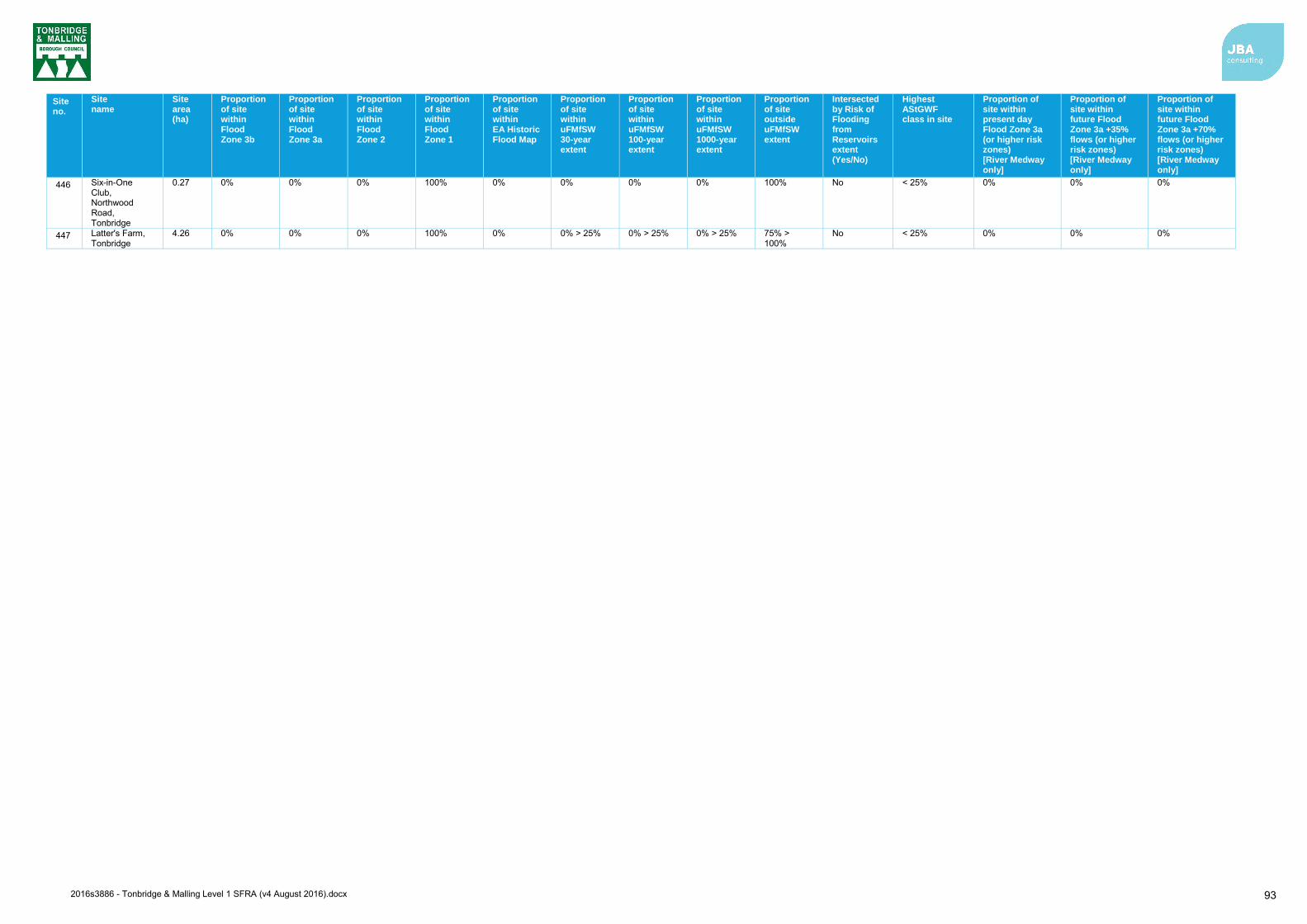
2016s3886 - Tonbridge & Malling Level 1 SFRA (v4 August 2016).docx 93
Site no.
Site name
Site area (ha)
Proportion of site within Flood Zone 3b
Proportion of site within Flood Zone 3a
Proportion of site within Flood Zone 2
Proportion of site within Flood Zone 1
Proportion of site within EA Historic Flood Map
Proportion of site within uFMfSW 30-year extent
Proportion of site within uFMfSW 100-year extent
Proportion of site within uFMfSW 1000-year extent
Proportion of site outside uFMfSW extent
Intersected by Risk of Flooding from Reservoirs extent (Yes/No)
Highest AStGWF class in site
Proportion of site within present day Flood Zone 3a (or higher risk zones) [River Medway only]
Proportion of site within future Flood Zone 3a +35% flows (or higher risk zones) [River Medway only]
Proportion of site within future Flood Zone 3a +70% flows (or higher risk zones) [River Medway only]
446 Six-in-One Club, Northwood Road, Tonbridge
0.27 0% 0% 0% 100% 0% 0% 0% 0% 100% No < 25% 0% 0% 0%
447 Latter's Farm, Tonbridge
4.26 0% 0% 0% 100% 0% 0% > 25% 0% > 25% 0% > 25% 75% > 100%
No < 25% 0% 0% 0%
2016s3886 - Tonbridge & Malling Level 1 SFRA (v4 August 2016).docx 94
13 Summary 13.1 Level 1 SFRA Assessment
The Level 1 assessment can be summarised as follows:
13.1.1 Sources of flood risk Tonbridge and Malling Borough has a history of documented flood events from several
sources of flood risk. Flood records indicate that the main source of risk is from fluvial sources.
The principle watercourses flowing through Tonbridge and Malling Borough are the River Medway and its tributaries, which include the Hilden Brook, Hawden Stream, Pen Stream, River Bourne, Coult Stream, Alder Stream and Snodland Mill Stream. The main source of fluvial flood risk is associated with the River Medway, caused by runoff and catchment inflows in the south and estuarine/tidal water levels in the north.
The most significant flood events reported to have affected Tonbridge and Malling occurred in 1953, 1968, 2000 and 2013/2014, each of which included notable flooding from the River Medway.
Historic records also indicate that Tonbridge and Malling Borough has experienced several surface water / drainage related flood events, which have been attributed to a range of sources. The Tonbridge and Malling SWMP identifies that historical records of surface water flooding are dispersed throughout the borough. The primary source of surface water flooding is attributed to heavy rainfall overloading highway carriageways and paved areas, drains and gullies, but other sources of flooding were perceived to be from blockages and high water levels impeding free discharge from surface water drains and gullies. The updated Flood Map for Surface Water (uFMfSW) shows a number of surface water flow paths which predominantly follow topographical flow paths along existing watercourses or dry valleys with some isolated ponding located in low lying areas.
Only two groundwater flood events have been recorded across the borough. The causes of these are thought to be related to high water tables and burst underground pipes rather than flooding from hard rock aquifers of superficial deposits. However, the Areas Susceptible to Groundwater Flooding (AStGWF) mapping suggests that susceptibility to groundwater flooding is greatest in the north of the borough, specifically in the areas of Birling, New Hythe, Leybourne and Snodland. This groundwater flood potential is consistent with the location of more permeable strata to the north of the borough.
The Sewer Incident Report Form data supplied by Southern Water indicates a total of 83 recorded flood incidents within Tonbridge and Malling. The more frequently flooded postcodes are TN9 1, TN11 9 and ME20 6. However, it is important to recognise that the information does not present whether flooding incidences were caused by general exceedance of the design sewer system, or by operational issues such as blockages.
In relation to artificial sources of flooding, there are no records of flooding from reservoirs impacting properties inside the borough. The Environment Agency’s Risk of Flooding from Reservoir’s flood extent mapping indicates that reservoirs in or outside of the borough could affect properties in the event of a breach. This includes the Leigh Flood Storage Area, located at the south west extent of the borough, and a breach of which could have notable implications for Tonbridge and the wider borough area.
13.1.2 Key Policies There are a number of regional and local key policies which have been considered with the SFRA. The regional policies include the River Medway CFMP (2009), the River Thames Basin Management Plan (2009), the Medway Estuary and Swale SMP (2010) and the Thames River Basin District Flood Risk Management Plan (FRMP) - Parts A, B, C and D (March 2016).
Key local policies include the following:

2016s3886 - Tonbridge & Malling Level 1 SFRA (v4 August 2016).docx 95
Thames River Basin District Flood Risk Management Plan (FRMP): within Part C identified priorities are to implement outcomes of the Middle Medway Strategy and improve flood warning.
Kent County Council Preliminary Flood Risk Assessment (PFRA): The PFRA reports significant past and future flooding from all sources except Main Rivers, the Sea and Reservoirs, which are covered by the Environment Agency, and sub-standard performance of the adopted sewer network (covered under the remit of Southern Water). The Flood Risk Regulations (2009) require the Lead Local Flood Authority (LLFA) to identify significant Flood Risk Areas. No Flood Risk Areas have been identified in Tonbridge and Malling Borough based on critical infrastructure/access routes, sewer/surface water problems and areas prone to significant ponding.
Kent Local Flood Risk Management Strategy (2013): The Strategy is used as a means by which the LLFA co-ordinates Flood Risk Management on a day to day basis and sets out measures to manage local flood risk (i.e. flood risk from surface water, groundwater and Ordinary Watercourses). The Strategy also sets out an action plan of how the LLFA intends to achieve the high-level objectives proposed for managing flood risk.
Surface Water Management Plans (SWMPs): SWMPs are produced to understand the flood risks that arise from local flooding, which is defined by the Flood and Water Management Act 2010 as flooding from surface runoff, groundwater, and Ordinary Watercourses. Options to alleviate the risks are identified and presented as a long-term action plan to manage local flooding in a particular area. The SWMPs relevant to Tonbridge and Malling Borough that have been considered in this SFRA are the:
o Tonbridge and Malling Stage 1 SWMP (2013) o Maidstone and Malling Stage 1 SWMP (2012)
13.1.3 Development and flood risk A Sequential risk based approach has been adopted to the preparation of the Level 1 SFRA which has involved an interactive process for the selection of appropriate potential development sites for the Local Plan. The relatively extensive areas of land available for potential housing development in Zones 1 and 2 has made it possible to align the selection of housing land when performing the Sequential Test so all potential new housing sites can be located on land outside of the high risk Flood Zone. Where potential housing sites are shown to comprise some land in a high risk Flood Zone, proposed development will only be allowed to take place on land zoned as medium or low risk, and if appropriate any supplementary housing will be located on land immediately adjacent to the housing site on land in a medium or low risk Zone. Since it is not proposed to place any proposed housing development on land in a high flood risk Zone there is no trigger to apply the Exception Test and, therefore, no requirement to prepare a Level 2 SFRA, as there is not a need to demonstrate proposed development is safe during a flood for land allocations in the Plan. This SFRA provides details of the FRA requirements and guidance for developers. These recommendations include those of the NPPF, Environment Agency standing advice, as well as reference to regional and local policy. Site-specific FRAs should include assessment of mitigation measures required to safely manage flood risk along with the promotion of Sustainable Drainage Systems (SuDS) to create a conceptual drainage strategy and safe access/egress at the development in the event of a flood.
Surface water flooding and the role of the LLFA and the Local Planning Authority (LPA) in surface water management has also been defined with guidance provided for the design and implementation of SuDS as part of the initial planning stage of all types of residential, commercial and industrial developments. The SFRA provides details of the types of SuDS available and when they should be used, and outlines the recommendations included in the relevant national, regional and local guidance documents.
The merits of strategic flood risk solutions should be identified and understood when considering development within the borough as these can involve measures that deliver wider strategic benefits and can be more easily and efficiently maintained than a myriad of individual smaller scale measures. Developers should work with stakeholders to identify issues and provide appropriate solutions.

2016s3886 - Tonbridge & Malling Level 1 SFRA (v4 August 2016).docx 96
13.1.4 Defences and residual risk A high-level review of formal flood defences was carried out using existing information to provide an indication of their condition and standard of protection. Details of the flood defence locations and condition were provided by the Environment Agency for the purpose of preparing this assessment, in addition to explanations of some of these defences.
Alongside the current flood risk management infrastructure within the borough, the Environment Agency are considering additional flood risk management measures. However, it is uncertain whether and in what form these will proceed at this time. When considering proposed development consideration must be given to the status and timing of FRM measures and schemes to provide evidence on whether a proposed development may benefit from, hinder, adjust or facilitate delivery and implementation.
13.1.5 Flood warning and emergency planning Emergency planning considerations have been included and the flood warning service coverage assessed; currently there are three Flood Alert Areas and seven Flood Warning Areas covering Tonbridge and Malling Borough. Requirements outlined by the NPPF for safe access and egress have also been set out.
13.2 Recommendations
13.2.1 Assessing Flood Risk and Developments The NPPF supports a risk-based and sequential approach to development and flood risk
in England, so that development is located in the lowest flood risk areas where possible; it is recommended that this approach is adopted for all future developments within the borough.
A site-specific FRA is required for all developments which are located in the Environment Agency’s Flood Zones 2 and 3, or developments greater than 1ha in size in Flood Zone 1. They are also required for developments less than 1 ha in Flood Zone 1 where there is a change in use to a more vulnerable development where they could be affected by sources of flooding other than rivers and the sea (e.g. surface water drains, reservoirs). All developments located in areas of Flood Zone 1 highlighted as having critical drainage problems must also be accompanied by an FRA. The FRA should be proportionate to the degree of flood risk, as well as the scale, nature and location of the development.
It is recommended that the impact of climate change to a proposed site is considered in FRAs and that the percentage increases which relate to the proposed lifetime of the development and the vulnerability classification of the development is identified and taken into account. The Environment Agency and LLFA should be consulted to confirm a suitable approach to climate change in light of the latest guidance.
Opportunities to reduce flood risk to wider communities could be sought through the regeneration of brownfield sites, through reductions in the amount of surface water runoff generated on a site.
The LPA, Environment Agency and LLFA should be consulted to confirm the level of assessment required and to provide any information on any known local issues.
When assessing sites not identified in the Local Plan (windfall sites), developers should use evidence provided in this SFRA to apply the Sequential Test as well as provide evidence to show that they have adequately considered other reasonably available sites.
13.2.2 Future Developments Development must seek opportunities to reduce overall levels of flood risk at the site, for example by:
Reducing volume and rate of surface water runoff based on Local Plan policy and LLFA Guidance
Locating development to areas with lower flood risk Creating space for flooding.

2016s3886 - Tonbridge & Malling Level 1 SFRA (v4 August 2016).docx 97
Integrating green infrastructure into mitigation measures for surface water runoff from potential development and consider using Flood Zones 2 and 3 as public open space.
The LPA should consult the NPPF and Environment Agency’s ‘Flood Risk Standing Advice (FRSA) for Local Planning Authorities’, published in March 2014, when reviewing planning applications for proposed developments at risk of flooding.
At the planning application stage, developers may need to undertake more detailed hydrological and hydraulic assessments of the watercourses to verify flood extent (including latest climate change allowances) inform development zoning within the site and prove, if required, whether the Exception Test can be passed.
13.2.3 Promotion of SuDS Planners should be aware of the conditions set by the LLFA for surface water management and ensure development proposals and applications are compliant with the Council’s policy. These policies should also be incorporated into the Local Plan.
A detailed site-specific assessment of SuDS would be needed to incorporate SuDS successfully into the development proposals. New or re-development should adopt source control SuDS techniques to reduce the risk of frequent low impact flooding due to post-development runoff.
For proposed developments, it is imperative that a site-specific infiltration test is conducted early on as part of the design of the development, to confirm whether the water table is low enough to allow for SuDS techniques that are designed to encourage infiltration.
Where sites lie within or close to Groundwater Source Protection Zones or aquifers, there may be a requirement for a form of pre-treatment prior to infiltration. Further guidance can be found in the CIRIA SuDS manual on the level of water quality treatment required for drainage via infiltration. Further restrictions may still be applicable and guidance should be sought from the LLFA.
Developers need to ensure that new development does not increase the surface water runoff rate from the site and should therefore contact the LLFA and other key stakeholders at an early stage to ensure surface water management is undertaken and that SuDS are promoted and implemented, designed to overcome site-specific constraints.
The LPA will need to consider drainage schemes for major applications, but it is advised developers utilise the LLFA’s Polices and Guidance to develop their drainage scheme for minor applications.
13.2.4 Infrastructure and Access Safe access and egress will need to be demonstrated at development sites. Consideration of alternative access and egress routes should be made in the event that primary routes are inundated with flood water. Resilience measures will be required if buildings are situated in the flood risk area, and opportunities to enhance green infrastructure and reduce flood risk by making space for water should be sought.
13.2.5 Green Infrastructure and WFD Opportunities to enhance green infrastructure and reduce flood risk by making space for water should be sought. In addition, opportunities where it may be possible to improve the WFD status of watercourses, for example by opening up culverts, weir removal, and river restoration, should be considered. Green infrastructure should be considered within the mitigation measures for surface water runoff from development.
13.3 Use of SFRA data and future updates It is important to recognise that the SFRA has been developed using the best available information at the time of preparation.
The SFRA should be periodically updated when new information on flood risk, flood warning or new planning guidance or legislation becomes available. New information on flood risk may be provided by authorities including Tonbridge and Malling Borough Council, Kent County Council (in its role as LLFA), the Highways Authority, Southern Water and the Environment Agency. It is

2016s3886 - Tonbridge & Malling Level 1 SFRA (v4 August 2016).docx 98
recommended that the SFRA is reviewed internally on an annual basis, allowing a cycle of review, followed by checking with the above bodies for any new information to allow a periodic update.

2016s3886 - Tonbridge & Malling Level 1 SFRA (v4 August 2016).docx I
Appendices

2016s3886 - Tonbridge & Malling Level 1 SFRA (v4 August 2016).docx II
A Index grid squares for Appendix mapping

2016s3886 - Tonbridge & Malling Level 1 SFRA (v4 August 2016).docx III
B Watercourses in Tonbridge and Malling Borough

2016s3886 - Tonbridge & Malling Level 1 SFRA (v4 August 2016).docx IV
C Flood Zone mapping
2016s3886 - Tonbridge & Malling Level 1 SFRA (v4 August 2016).docx V
D Climate change mapping This information is supplied for the River Medway only as flood modelling and mapping following the latest guidance was available for the River Medway at the time of preparing the SFRA. Updated information for other watercourses within the borough may become available in the future and this should be checked if influential for proposed development sites.

2016s3886 - Tonbridge & Malling Level 1 SFRA (v4 August 2016).docx VI
E Surface water mapping

2016s3886 - Tonbridge & Malling Level 1 SFRA (v4 August 2016).docx VII
F Groundwater mapping
2016s3886 - Tonbridge & Malling Level 1 SFRA (v4 August 2016).docx VIII
G Flood warning coverage

Offices at
Coleshill Doncaster Dublin Edinburgh Exeter Glasgow Haywards Heath Isle of Man Limerick Newcastle upon Tyne Newport Peterborough Saltaire Skipton Tadcaster Thirsk Wallingford Warrington
Registered Office
South Barn Broughton Hall SKIPTON North Yorkshire BD23 3AE United Kingdom
t:+44(0)1756 799919 e:[email protected] Jeremy Benn Associates Ltd
Registered in England 3246693
Visit our website
www.jbaconsulting.com