tour - ose.state.nm.us · tour gila river, nm june 11-12, 2015 bureau of reclamation new mexico...
TRANSCRIPT
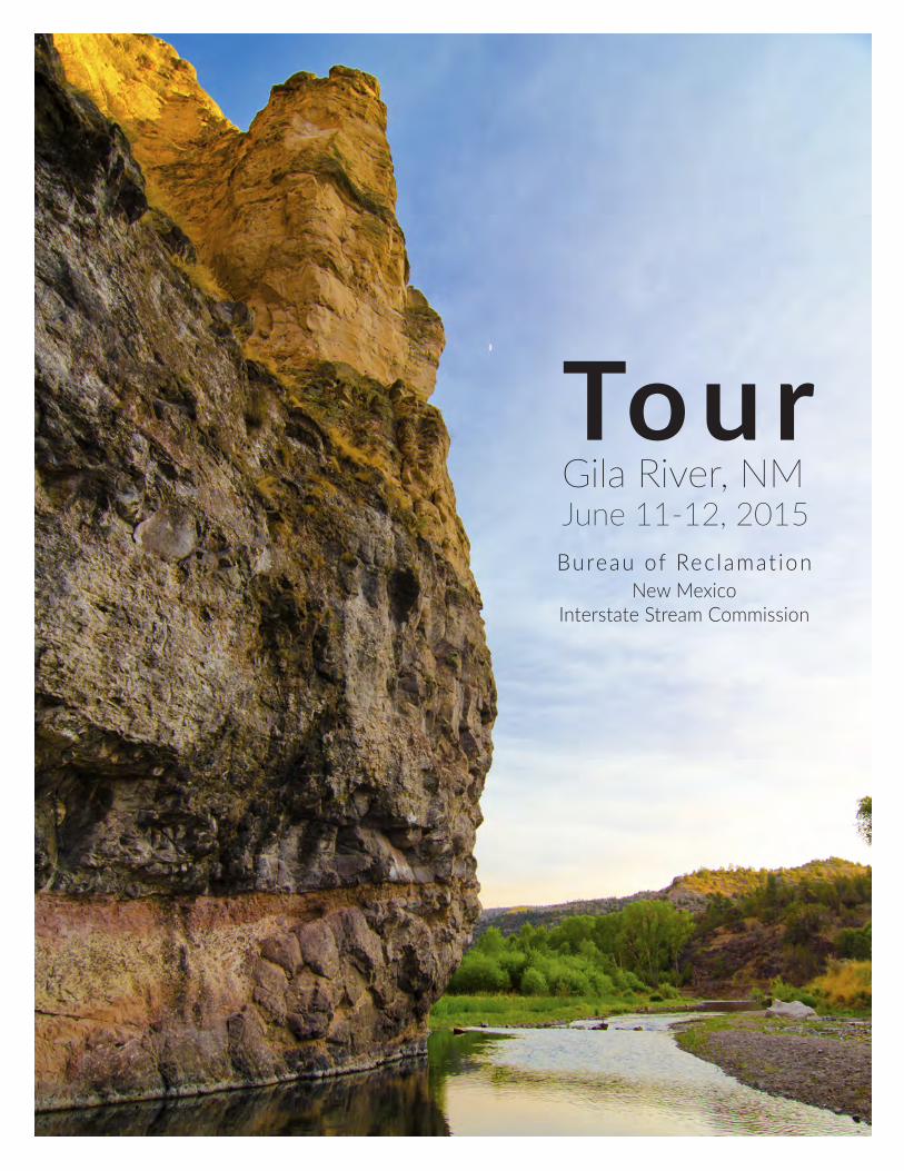
TourGila River, NMJune 11-12, 2015Bureau of Rec lamat ion
New Mexico Interstate Stream Commission

Table of Contents
Demographic Snapshot of Region 3
Drought Update 4
New Mexico SNOTEL Maps and Data 5
Four County Study Map 6
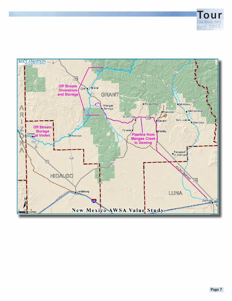
Value Study Map 7
Tour Map 8
Continental Divide 9
Stop 1: Upper Cliff-Gila Valley Overlook 10
Stop 2: Brock Canyon Diversion Point 11
Stop 3: Spar Canyon 12-13
Stop 4: Gila Farms Ditch Point of Diversion 14
Stop 5: Highway 211 Bridge 15
Stop 6: Winn Canyon 16-17
Stop 7: Mogollon Creek Confluence 18
Stop 8: Stream Gauge Divserion Point 19
Stop 9: Sycamore Canyon 20
Stop 10: Pope Canyon 21
Stop 11: Greenwood Canyon 22
Stop 12: Bill Evans Lake Diversion Structure and Lake 23
Reclamation Diversion Alternative Maps 24-28
Reclamation Storage Facility Tables 29-31
Reclamation’s Deming Pipeline Alignment 32
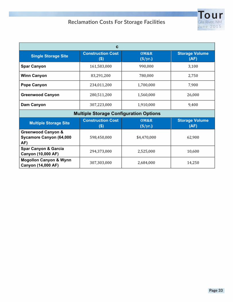
Reclamation Storage Facility Costs 33
BHI Maps of Alternatives 34-38
Preliminary Engineering Report For BHI Phase II Engineering
Evaluation of AWSA Diversion and Storage Proposals 39-50
RJH Study 51-60
Contact Information 61
Page 2
TourGila River, NMJ u n e 2 0 1 5
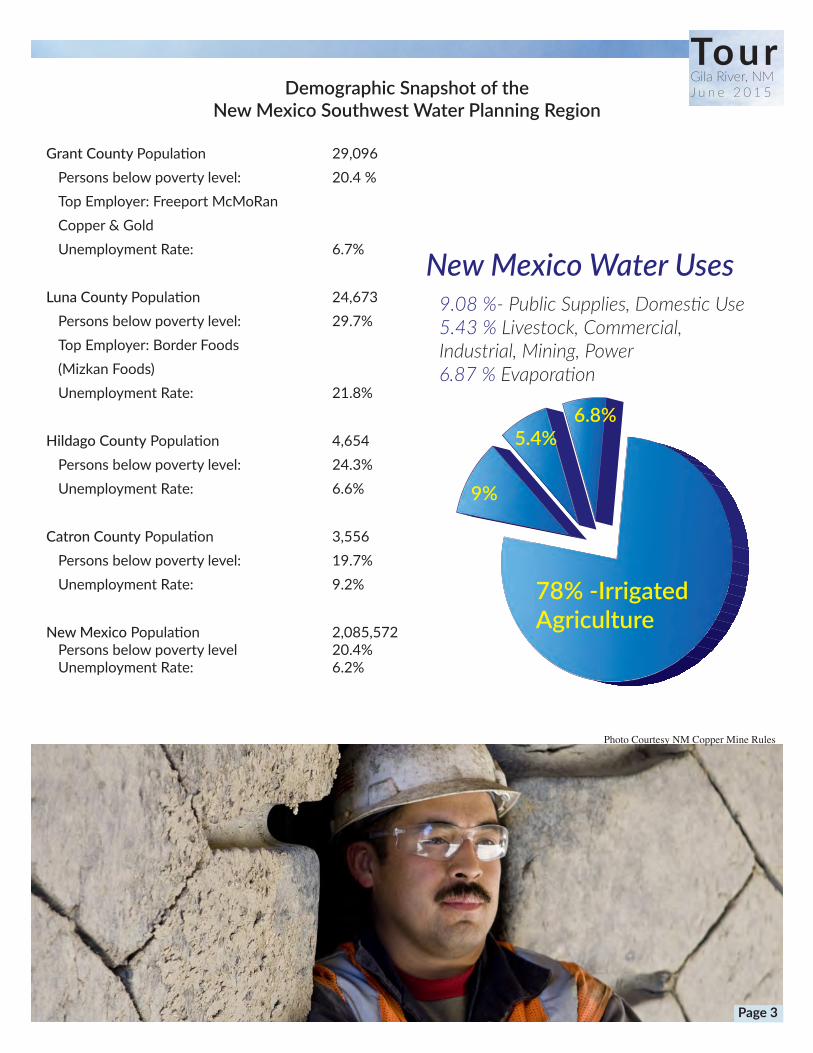
Demographic Snapshot of the New Mexico Southwest Water Planning Region
Grant County Population 29,096 Personsbelowpovertylevel: 20.4% TopEmployer:FreeportMcMoRan Copper&Gold UnemploymentRate: 6.7%
Luna County Population 24,673 Personsbelowpovertylevel: 29.7% TopEmployer:BorderFoods (MizkanFoods) UnemploymentRate: 21.8%
Hildago CountyPopulation 4,654 Personsbelowpovertylevel: 24.3% UnemploymentRate: 6.6%
Catron CountyPopulation 3,556 Personsbelowpovertylevel: 19.7% UnemploymentRate: 9.2%
New Mexico Population 2,085,572 Personsbelowpovertylevel 20.4% UnemploymentRate: 6.2%
Photo Courtesy NM Copper Mine Rules
TourGila River, NMJ u n e 2 0 1 5
New Mexico Water Uses9.08 %- Public Supplies, Domestic Use5.43 % Livestock, Commercial, Industrial, Mining, Power6.87 % Evaporation
78% -Irrigated Agriculture
9%
5.4%6.8%
Page 3

Substantial Improvement in Current Drought Status For New Mexico
Currently 47% Drought FreeCompared to 42 %
Exceptional Drought in July 2013
TourGila River, NMJ u n e 2 0 1 5
Page 4

TourGila River, NMJ u n e 2 0 1 5
!!
!!
!!
_̂
!_̂(
Taos
Roswell
Las Cruces
Santa Fe
Albuquerque
Rio Hondo
Mimbres River
Gila River
Rio Chama
River
Pecos River
Jemez River
San Francisco
River
Zuni/Bluewater
River
Cimarron River
Sangre De Cristo Mountain Range
72
70
95
6393
96
100
103
126106
New MexicoSNOTEL Water Year (Oct 1) to Date Precipitation % of Normal
0 20 40 60 80 10010Miles
Provisional Data Subject to Revision
unavailable *
<50%
50 - 69%
70 - 89%
90 - 109%
110 - 129%
130 - 149%
>=150%
Water Year (Oct 1)to Date PrecipitationBasin-wide Percent% of 1981-2010 Average
May 28, 2015
* Data unavailable at time of posting or measurement is not representative at this time of year
Prepared by:USDA/NRCS National Water and Climate Center Portland, Oregonhttp://www.wcc.nrcs.usda.gov
The water year to date precipitation percent of normal represents the accumulated precipitation found at selected SNOTEL sites in or near the basin compared to the average value for those sites on this day. Data based on the first reading of the day (typically 00:00).
Current New Mexico Snotel Reports
Page 5
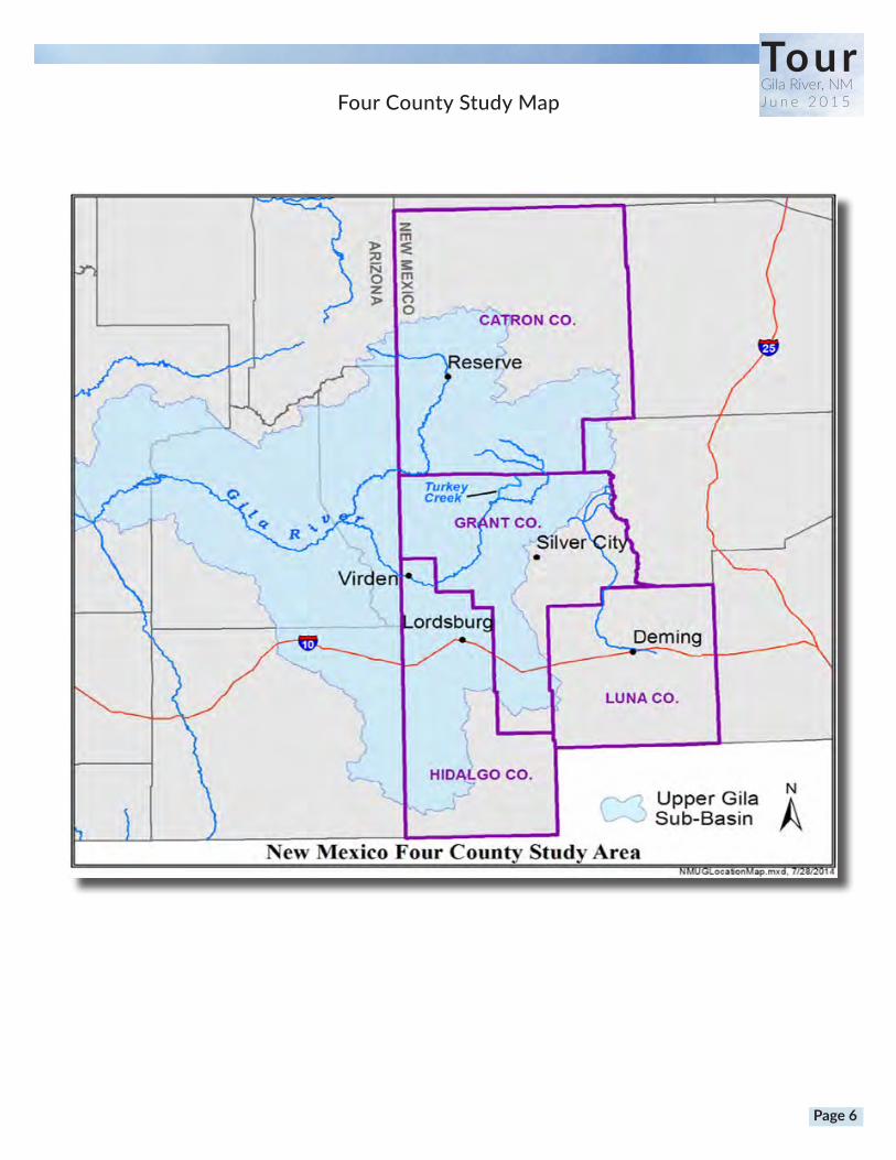
Four County Study Map
TourGila River, NMJ u n e 2 0 1 5
Page 6
TourGila River, NMJ u n e 2 0 1 5
Page 7
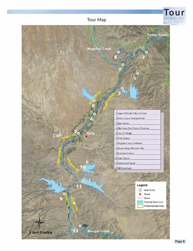
Tour MapTourGila River, NMJ u n e 2 0 1 5
Page 8

Continental Divide
ContinentalDivide(onHighway180)Elevation: 6,230feetDiversionAlternative2Elevation: 4,695feetGila,NMElevation: 4,557feetSilverCity,NMElevation: 5,895feetDeming,NMElevation: 4,300feetVirden,NMElevation: 3,763feet
TourGila River, NMJ u n e 2 0 1 5
Page 9
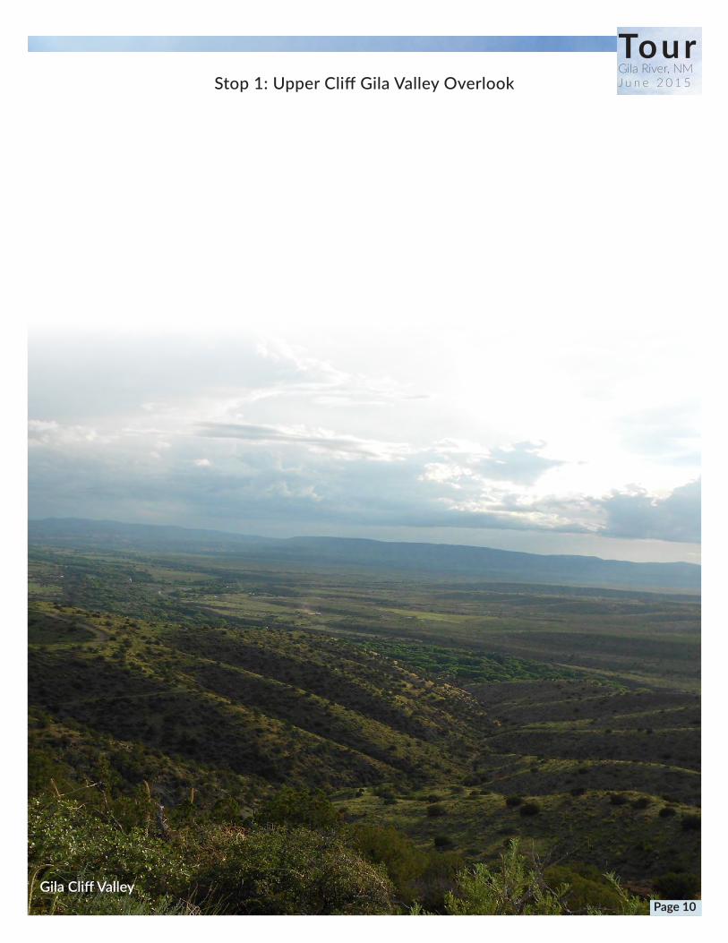
Stop 1: Upper Cliff Gila Valley Overlook
Gila Cliff Valley
TourGila River, NMJ u n e 2 0 1 5
Page 10
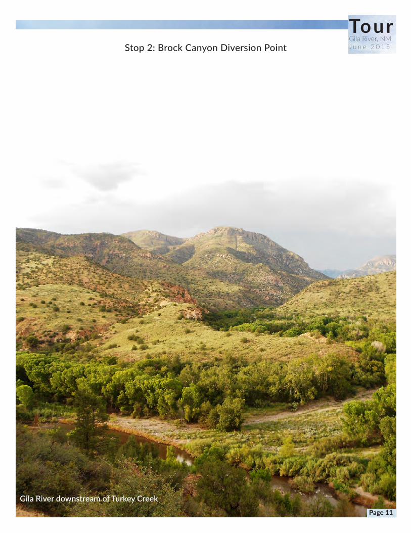
TourGila River, NMJ u n e 2 0 1 5Stop 2: Brock Canyon Diversion Point
Gila River downstream of Turkey Creek Page 11
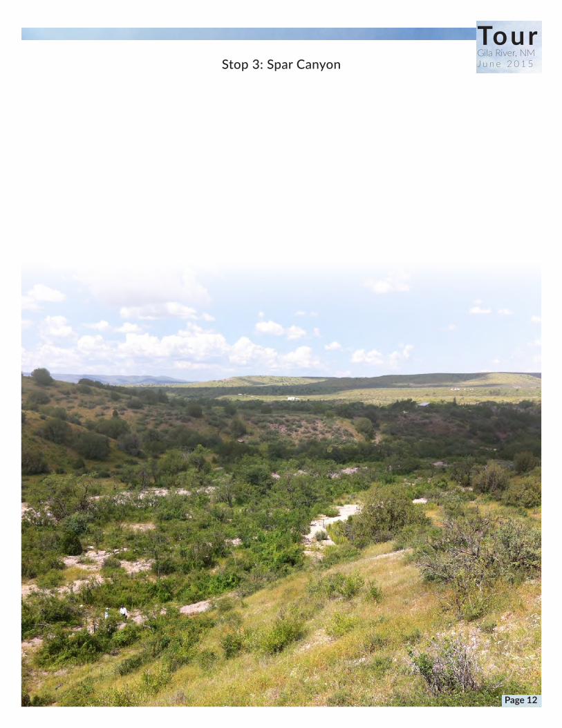
Stop 3: Spar Canyon
TourGila River, NMJ u n e 2 0 1 5
Page 12
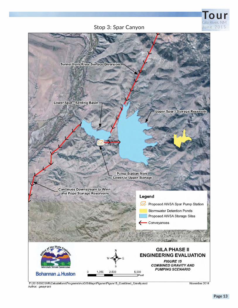
Stop 3: Spar Canyon
TourGila River, NMJ u n e 2 0 1 5
Page 13

TourGila River, NMJ u n e 2 0 1 5Stop 4: Gila Farms Ditch Point of Diversion
Page 14
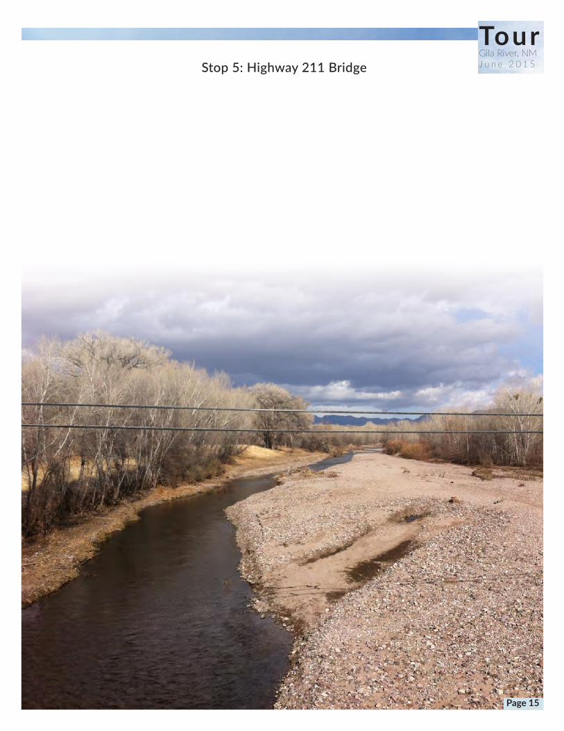
Stop 5: Highway 211 Bridge
TourGila River, NMJ u n e 2 0 1 5
Page 15
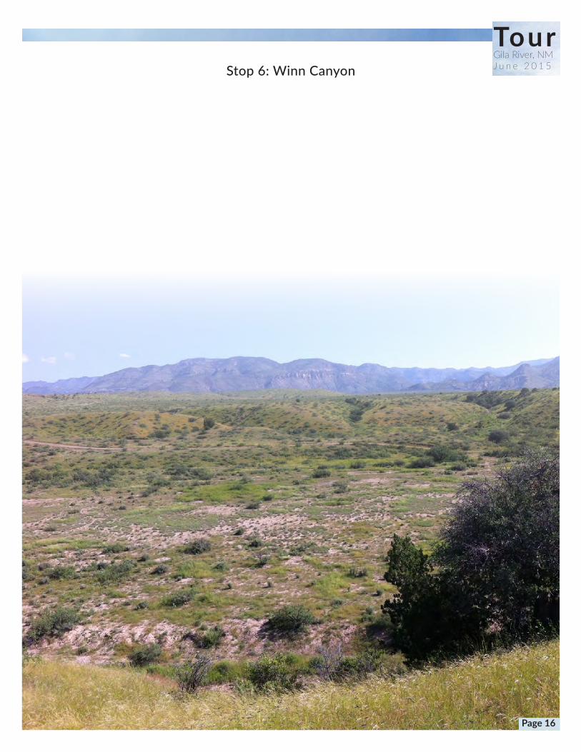
TourGila River, NMJ u n e 2 0 1 5Stop 6: Winn Canyon
Page 16
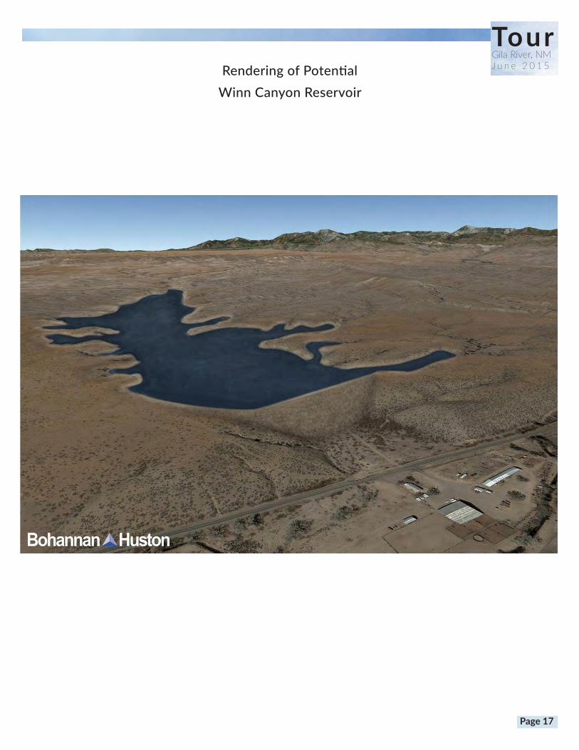
TourGila River, NMJ u n e 2 0 1 5Rendering of Potential
Winn Canyon Reservoir
Page 17

Stop 7: Mogollon Creek Confluence
Gila River at Confluence of Mogollon Creek Jan 2014
TourGila River, NMJ u n e 2 0 1 5
Page 18
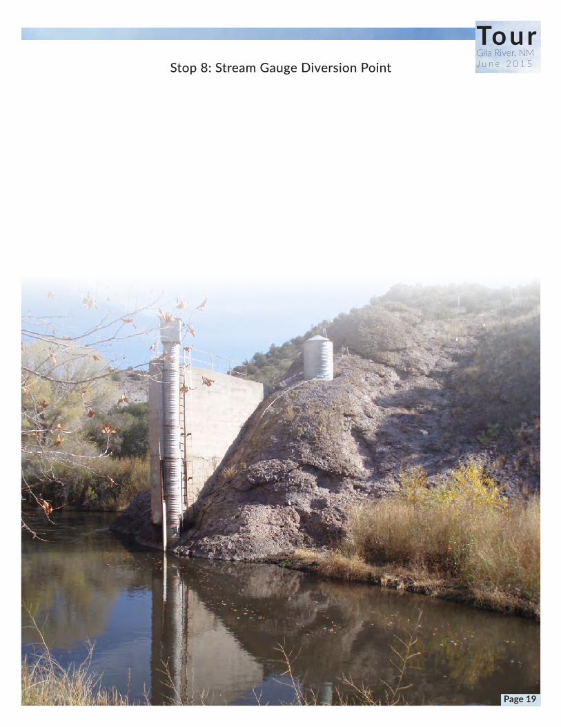
Stop 8: Stream Gauge Diversion Point
TourGila River, NMJ u n e 2 0 1 5
Page 19
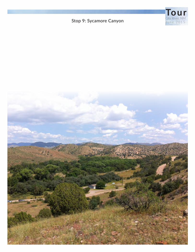
TourGila River, NMJ u n e 2 0 1 5Stop 9: Sycamore Canyon
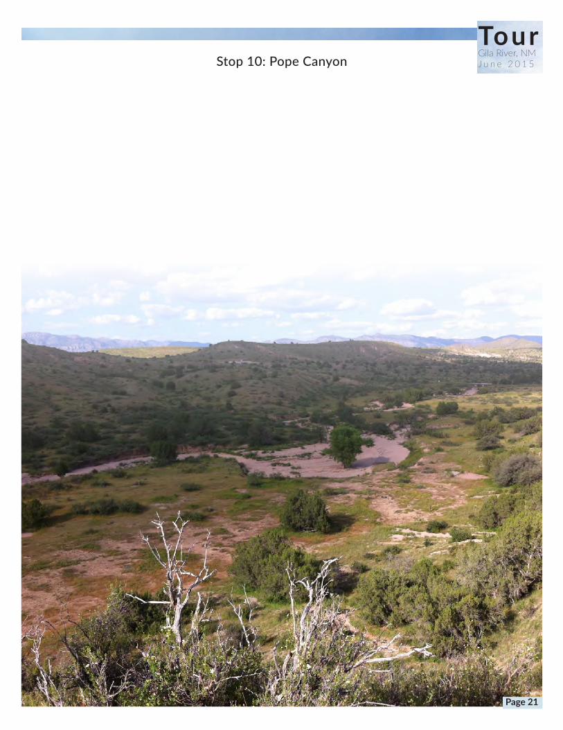
TourGila River, NMJ u n e 2 0 1 5Stop 10: Pope Canyon
Page 21
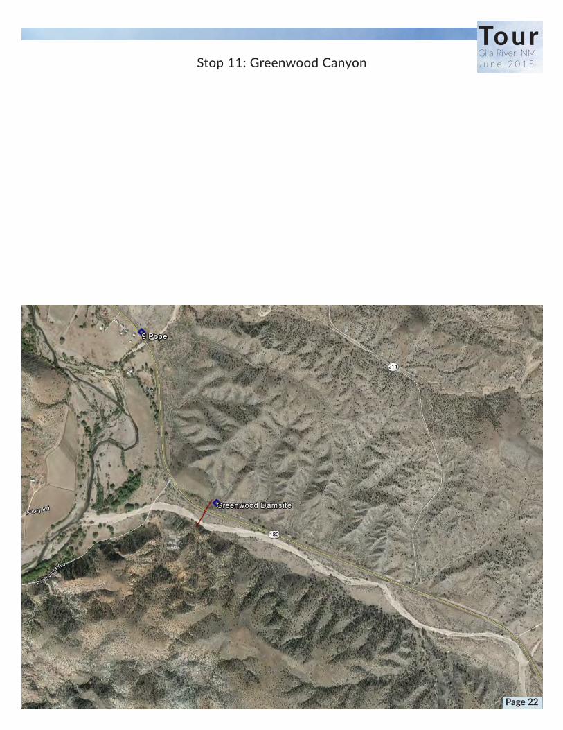
Stop 11: Greenwood Canyon
TourGila River, NMJ u n e 2 0 1 5
Page 22
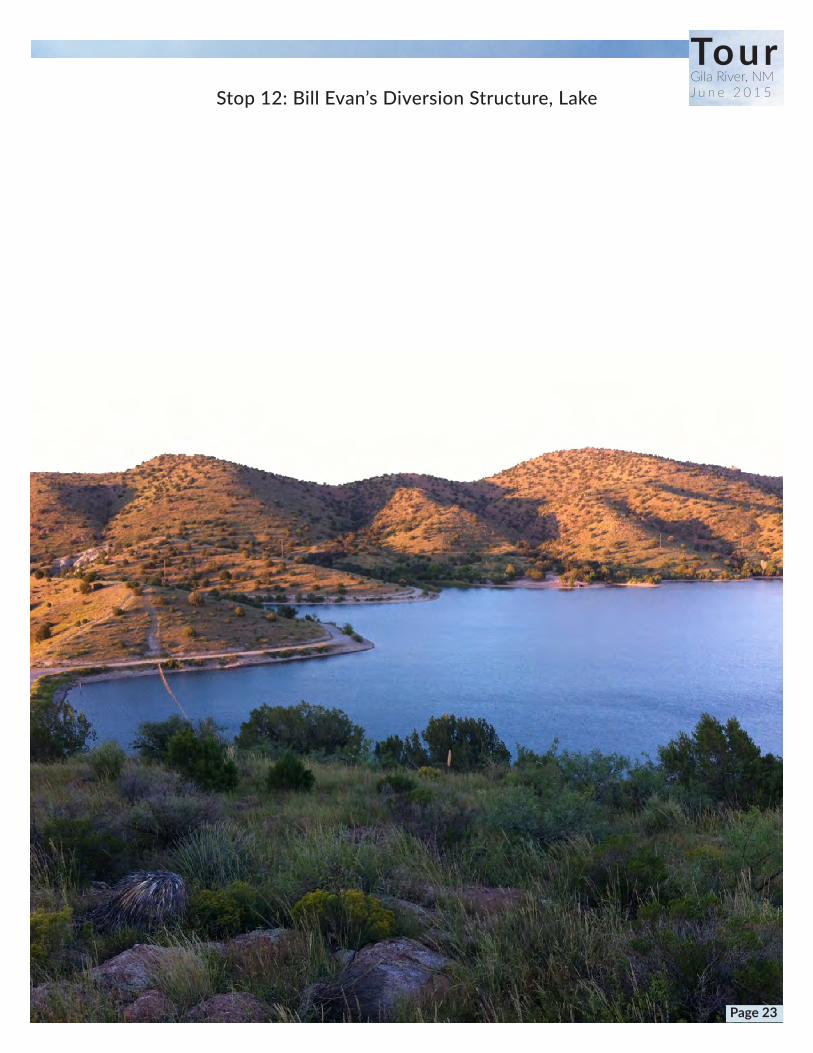
Stop 12: Bill Evan’s Diversion Structure, Lake
TourGila River, NMJ u n e 2 0 1 5
Page 23

TourGila River, NMJ u n e 2 0 1 5
Reclamation Maps

Greenwood Canyon
Winn Canyon Spar Canyon
Northrup Canyon
Gila
River
Bill EvansLake
Mogollon Creek
Diversion 1
2,031
Sycamore Canyon
Dam Canyon
Pope Canyon
Dix CanyonSpring Canyon
Davis Canyon
Cherokee Canyon
Mangas Creek
SchoolhouseCanyon
West Fork
Schoolhouse Canyon
Pancho
Canyon
Patterson
Canyon
Ira Canyon
Road
Cany
on
Moonhull
Canyon
Bear Creek
Garcia Canyon
Lobo CreekBell Canyon Maldonado Canyon
Duck Creek
36,905
22,190
25,952
7,879
2,775
4,158
2,750
4,393
2,829
4,070
3,757
839
3,781
1,153
1,536
1,613
613
1,524
475
447
Gila Farm
Ft. West
Upper Gila
Bill Evans
Riverside
Clark
Diversion1.mxd, 4/7/2014
±0 10.5
Miles
Storage Capacity in AF
Existing DiversionsDiversion
Conveyance
Storage
Diversion 1Alternative
Diversion 1
Conveyance
TourGila River, NMJ u n e 2 0 1 5
Page 25

Winn Canyon
Spar Canyon
Northrup Canyon
Gila
River
Bill EvansLake
Mogollon Creek
Diversion 2
890
Sycamore Canyon
Dam Canyon
Pope Canyon
Dix Canyon Spring Canyon
Davis Canyon
Cherokee Canyon
Mangas Creek
SchoolhouseCanyon
West Fork
Schoolhouse Canyon
Pancho
Canyon
Patterson
Canyon
Ira Canyon
Road
Cany
on
Moonhull
Canyon
Bear Creek
Garcia Canyon
Lobo Creek
Bell Canyon
Maldonado Canyon
Duck Creek
3,675
999
2,031
GreenwoodCanyon
50,667
35,057
46,777
6,557
21,288
8,814
3,268
9,406
3,629
5,436
5,960
4,095
5,769
2,836
3,668
3,039
2,046
1,524
844
678
Gila Farm
Ft. West
Upper Gila
Bill Evans
Riverside
Clark
Diversion2.mxd, 4/7/2014
±0 10.5
Miles
Storage Capacity in AF
Storage
Diversion 2Alternative
Diversion 2
Conveyance
Existing DiversionsDiversion
Conveyance
TourGila River, NMJ u n e 2 0 1 5
Page 26

Winn Canyon
Spar CanyonGila
River
Bill EvansLake
Mogollon Creek
Diversion 3
2,700
SycamoreCanyon
Dam Canyon
Pope Canyon
Dix Canyon Spring Canyon
Davis Canyon
Cherokee Canyon
Mangas Creek
SchoolhouseCanyonW
est Fork
Schoolhouse Canyon
Pancho
Canyon
Patterson
Canyon
Ira Canyon
Road
Cany
on
Moonhull
Canyon
Bear Creek
Garcia Canyon
Lobo CreekBell Canyon
Maldonado Canyon
Duck Creek
10,078
2,216
3,930
GreenwoodCanyon
Northrup Canyon
28,470
61,546
46,777
1,996
35,843
15,097
3,138
7,570
9,166
5,872
7,240
7,499
8,255
1,061
3,897
8,712
3,563
1,157
1,262
1,152
Gila Farm
Ft. West
Upper Gila
Bill Evans
Riverside
Clark
±0 10.5
Miles
Diversion3.mxd, 4/7/2014
Storage Capacity in AF
Storage
Diversion 3Alternative
Diversion 3
Conveyance
Existing DiversionsDiversion
Conveyance
TourGila River, NMJ u n e 2 0 1 5
Page 27

Winn Canyon
Spar CanyonGila
River
Bill EvansLake
Mogollon Creek
Diversion 4
3,070
SycamoreCanyon
Dam Canyon
Pope Canyon
Dix Canyon Spring Canyon
Davis Canyon
Cherokee Canyon
Mangas Creek
SchoolhouseCanyonW
est Fork
Schoolhouse Canyon
Pancho
Canyon
Patterson
Canyon
Ira Canyon
Road
Cany
on
Moonhull
Canyon
Bear Creek
Garcia Canyon
Lobo CreekBell Canyon
Maldonado Canyon
Duck Creek
11,546
2,216
3,930
GreenwoodCanyon
Northrup Canyon
29,940
61,546
46,777
1,996
35,843
15,097
2,162
7,570
11,586
6,409
7,240
7,499
8,687
1,210
4,164
9,147
3,609
1,157
1,262
1,243
Gila Farm
Ft. West
Upper Gila
Bill Evans
Riverside
Clark
Diversion4.mxd, 4/7/2014
±0 10.5
Miles
Storage Capacity in AF
Storage
Diversion 4Alternative
Diversion 4
Conveyance
Existing DiversionsDiversion
Conveyance
TourGila River, NMJ u n e 2 0 1 5
Page 28

TourGila River, NMJ u n e 2 0 1 5
Page 29

TourGila River, NMJ u n e 2 0 1 5
Page 30
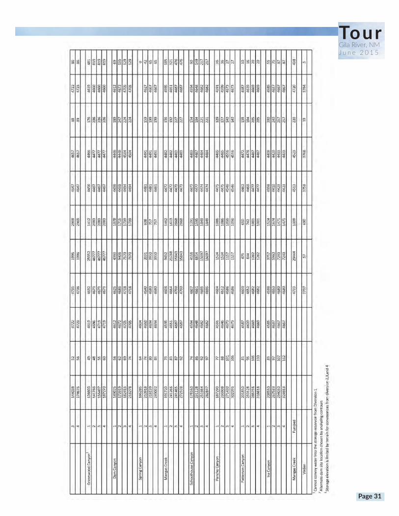
TourGila River, NMJ u n e 2 0 1 5
Page 31

TourGila River, NMJ u n e 2 0 1 5Pipeline to Deming
Page 32
TourGila River, NMJ u n e 2 0 1 5
c
Single Storage Site Construction Cost ($)
OM&R ($/yr.)
Storage Volume (AF)
Spar Canyon 161,583,000 990,000 3,100
Winn Canyon 83,291,200 780,000 2,750
Pope Canyon 234,011,200 1,700,000 7,900
Greenwood Canyon 280,511,200 1,560,000 26,000
Dam Canyon 307,223,000 1,910,000 9,400
Multiple Storage Configuration Options
Multiple Storage Site Construction Cost ($)
OM&R ($/yr.)
Storage Volume (AF)
Greenwood Canyon & Sycamore Canyon (64,000 AF)
598,450,000 $4,470,000 62,900
Spar Canyon & Garcia Canyon (10,000 AF) 294,373,000 2,525,000 10,600
Mogollon Canyon & Wynn Canyon (14,000 AF) 307,303,000 2,684,000 14,250
Reclamation Costs For Storage Facilities
Page 33
TourGila River, NMJ u n e 2 0 1 5
BHI Alternatives
Page 34

!(
!( !(
!(
!(
!(
!(
!(
Riffle
1
2 3
5
4
6
8
7
6200605059505850
5750
5650
5550
54505350
5000
4950
4900
4850
625061006000 5950 59
00
580056505550
5450
6150
6100
60005900
5800
57005600
5550
5350
5250
5200
5050
5000
4950
53005250
5200
5100
5050
560055005400
5300
5100
58505750
5700
5500
5400
5150
5150
4900
4850
555054005300 5250
5100
5000
4950
4900
48504800
5100
50505000
4950 4900
4850
5500
5450
5350
5600
4900
4800
490048
50
4950
4800
5000
5600
4750
Source: Esri, DigitalGlobe, GeoEye, i-cubed, Earthstar Geographics,CNES/Airbus DS, USDA, USGS, AEX, Getmapping, Aerogrid, IGN, IGP,swisstopo, and the GIS User Community
LegendPotential AWSA Diversion Locations!( Pre Site Visit
!( Recommended Site
!( Site VisitField Reconnaissance ReachIndex Contour (50 ft)Intermediate Contour (10 ft)
0 1,000 2,000500Feet
P:\20150063\WR\Calculations\Programs\ArcGIS\Maps\Figures\Figure4_Additional_Diversion_Locations.mxdAuthor: gmaynard
.GILA PHASE II
ENGINEERING EVALUATIONFIGURE 4
ADDITIONAL POTENTIAL AWSA DIVERSION LOCATIONS
November 2014
Turkey Creek
Gila River
Brushy Canyon
Brock Canyon
TourGila River, NMJ u n e 2 0 1 5
Page 35
TourGila River, NMJ u n e 2 0 1 5
,
,
,
,,
,,
,,
,,
,,
,
,,
,,,
,
, ,
, ,
,,
, ,,
,,
,,
,,
=
!(
J4
Copyright:© 2013 National Geographic Society, i-cubed
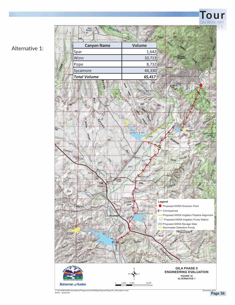
FIGURE 16ALTERNATIVE 1
GILA PHASE IIENGINEERING EVALUATION
P:\20150063\WR\Calculations\Programs\ArcGIS\Maps\Figures\Figure16_Alternative1.mxdAuthor: gmaynard
November 2014
Legend!( Proposed AWSA Diversion Point
, Conveyances
Proposed AWSA Irrigation Pipeline Alignment
= Proposed AWSA Irrigation Pump Station
Proposed AWSA Storage SitesStormwater Detention Ponds
0 6,000 12,0003,000Feet
.
SparWSEL = 4,713
WinnWSEL = 4,685
PopeWSEL = 4,616
SycamoreWSEL = 4,600
Canyon Name VolumeSpar 1,642Winn 10,713Pope 8,732Sycamore 44,330Total Volume 65,417
Alternative1:
Page 36

,
,
,
,,
,,
,,
,,
,,
,
,,
,,,
,
, ,
, ,
,,
, ,,
,,
,,
,,
=
!(
J4
Copyright:© 2013 National Geographic Society, i-cubed
FIGURE 17ALTERNATIVE 2
GILA PHASE IIENGINEERING EVALUATION
P:\20150063\WR\Calculations\Programs\ArcGIS\Maps\Figures\Figure17_Alternative2.mxdAuthor: gmaynard
November 2014
Legend!( Proposed AWSA Surface Diversion Point
Proposed AWSA Drain LinesProposed AWSA Collector Pipe
, Conveyances
= Proposed AWSA Irrigation Pump Station
Proposed AWSA Irrigation Pipeline AlignmentProposed AWSA Storage SitesStormwater Detention Ponds
0 6,000 12,0003,000Feet
.
SparWSEL = 4,713
WinnWSEL = 4,685
PopeWSEL = 4,616
SycamoreWSEL = 4,600
Canyon Name VolumeSpar 1,642Winn 10,713Pope 8,732Sycamore 44,330Total Volume 65,417
TourGila River, NMJ u n e 2 0 1 5
Alternative2:
Page 37
,
,
,,
,,
,,
,
,,
,
,
,
,
, ,
,,,,,
,
=
J4
Copyright:© 2013 National Geographic Society, i-cubed
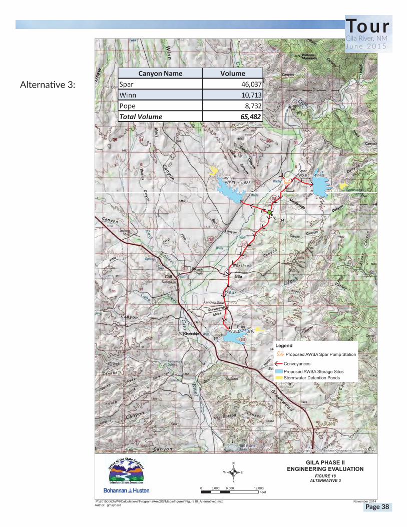
FIGURE 18ALTERNATIVE 3
GILA PHASE IIENGINEERING EVALUATION
P:\20150063\WR\Calculations\Programs\ArcGIS\Maps\Figures\Figure18_Alternative3.mxdAuthor: gmaynard
November 2014
Legend
= Proposed AWSA Spar Pump Station
, Conveyances
Proposed AWSA Storage SitesStormwater Detention Ponds
0 6,000 12,0003,000Feet
.
SparWSEL = 4,960Winn
WSEL = 4,685
PopeWSEL = 4,616
Canyon Name VolumeSpar 46,037Winn 10,713Pope 8,732Total Volume 65,482
TourGila River, NMJ u n e 2 0 1 5
Alternative3:
Page 38
PRELIMINARY ENGINEERING REPORT FORPHASE II ENGINEERING EVALUATION OF AWSA DIVERSION AND STORAGE PROPOSALS
Section IX Page 71 of 83P:\20150063\WR\Reports\Final\20150063 Final Gila_PER_.Docx
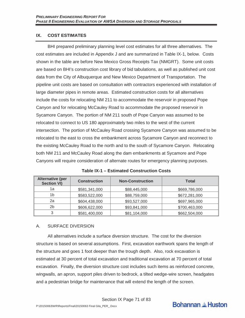
IX. COST ESTIMATES
BHI prepared preliminary planning level cost estimates for all three alternatives. The
cost estimates are included in Appendix J and are summarized in Table IX-1, below. Costs
shown in the table are before New Mexico Gross Receipts Tax (NMGRT). Some unit costs
are based on BHI’s construction cost library of bid tabulations, as well as published unit cost
data from the City of Albuquerque and New Mexico Department of Transportation. The
pipeline unit costs are based on consultation with contractors experienced with installation of
large diameter pipes in remote areas. Estimated construction costs for all alternatives
include the costs for relocating NM 211 to accommodate the reservoir in proposed Pope
Canyon and for relocating McCauley Road to accommodate the proposed reservoir in
Sycamore Canyon. The portion of NM 211 south of Pope Canyon was assumed to be
relocated to connect to US 180 approximately two miles to the west of the current
intersection. The portion of McCauley Road crossing Sycamore Canyon was assumed to be
relocated to the east to cross the embankment across Sycamore Canyon and reconnect to
the existing McCauley Road to the north and to the south of Sycamore Canyon. Relocating
both NM 211 and McCauley Road along the dam embankments at Sycamore and Pope
Canyons will require consideration of alternate routes for emergency planning purposes.
Table IX-1 – Estimated Construction Costs
Alternative (per Section VI) Construction Non-Construction Total
1a $581,341,000 $88,445,000 $669,786,0001b $583,522,000 $88,759,000 $672,281,0002a $604,438,000 $93,527,000 $697,965,0002b $606,622,000 $93,841,000 $700,463,0003 $581,400,000 $81,104,000 $662,504,000
A. SURFACE DIVERSION
All alternatives include a surface diversion structure. The cost for the diversion
structure is based on several assumptions. First, excavation earthwork spans the length of
the structure and goes 1 foot deeper than the trough depth. Also, rock excavation is
estimated at 30 percent of total excavation and traditional excavation at 70 percent of total
excavation. Finally, the diversion structure cost includes such items as reinforced concrete,
wingwalls, an apron, support piles driven to bedrock, a tilted wedge-wire screen, headgates
and a pedestrian bridge for maintenance that will extend the length of the screen.
PRELIMINARY ENGINEERING REPORT FORPHASE II ENGINEERING EVALUATION OF AWSA DIVERSION AND STORAGE PROPOSALS
Section IX Page 72 of 83P:\20150063\WR\Reports\Final\20150063 Final Gila_PER_.Docx
B. SUBSURFACE DIVERSION
Alternative 2 includes a subsurface diversion structure. The cost for the subsurface
diversion structure is based on several assumptions. First, a temporary construction
cofferdam and dewatering will be required at each diversion point along the infiltration
gallery. Also, trenching will be required for each diversion point. Finally, the subsurface
diversion structure cost includes such items as perforated pipe, blank casing for cleanouts
and access ports, 24 inch to 66 inch collector pipes, and headgates.
C. TUNNEL
The estimated cost for the tunnel proposed in Alternatives 1 and 2 is based on
consultation with a tunneling contractor that was documented in the April 2014 PER.
D. STORAGE RESERVOIRS
The estimated costs for the storage reservoirs are based on several assumptions,
which are discussed below.
1. All dams will require a black, 60 mil, HDPE liner, or equivalent (described in
more detail in Section IV.C.3 above). In addition to the HDPE liner at each dam,
a 12-inch thick compacted clay subgrade is included. The cost estimate for
Spar Canyon also includes a cost for a soil cement grade control slab across the
bottom of the dam pool.
2. Floodpool grading will be required before placement of the impermeable liner.
Earthwork has been optimized to better balance the cut and fill at each reservoir
site. A balanced earthwork approach should be taken to facilitate potential
construction phasing. Costs for excavation and backfill are based on the total
excavation at each site. The only dam that requires import is Sycamore. This
import is assumed to come from Winn and Pope, which both have excess
material available. The grading could be refined during design to reduce the
import required for construction of the dam at Sycamore and to reduce the
excess earth generated from excavation at Winn and Pope.
3. A concrete emergency spillway is assumed to extend down the downstream
side of each dam to convey flow over the top of the dam in the event of the
Probable Maximum Flood (PMF) or other overtopping situations. In addition, the
emergency spillway concrete is assumed to extend 5 feet down the upstream
PRELIMINARY ENGINEERING REPORT FORPHASE II ENGINEERING EVALUATION OF AWSA DIVERSION AND STORAGE PROPOSALS
Section IX Page 73 of 83P:\20150063\WR\Reports\Final\20150063 Final Gila_PER_.Docx
side of the dam, overlapping the HDPE liner. The dam slopes were assumed to
be 2:1 on the upstream side and 4:1 on the downstream side.
4. The cost for each reservoir site includes a cost for an upstream stormwater
detention facility. The stormwater detention facility costs are based on a graph
of dam storage vs. cost per acre-foot for previously constructed detention
facilities, in 2014 dollars.
E. SPAR CANYON RESERVOIR CONCEPTUAL OUTLET WORKS
The cost for the Spar Canyon Reservoir conceptual outlet works includes reinforced
concrete, wire-enclosed riprap at the orifice inlets, 72 inch pipe to convey 90 cfs to the Gila
River, 30 inch pipe connecting the 90 cfs orifice inlets to the 90 cfs outlet pipe to the Gila
River, and a ported riser for the 350 cfs outlet.
F. CONVEYANCE PIPES BETWEEN STORAGE RESERVOIRS
The estimated costs for conveyances between storage reservoirs are based on
assumptions that were documented in the April 2014 PER, including expected rock
trenching and excavation, as well as traditional excavation.
G. IRRIGATION PUMP STATION AT WINN CANYON
The cost for the 10 cfs irrigation pump station at Winn Canyon is based on several
assumptions. The cost includes a 24 inch pipeline from Winn Canyon to the Upper Gila
diversion site. Also included is a cast in place concrete clearwell, a 30 ft x 30 ft x 15 ft metal
building, one 4,500 gpm pump, 50 hp motor, VFD pump control and SCADA system.
Alternatively, the cost for a 50 cfs irrigation pump station at Winn Canyon is based on
a 42 inch pipeline from Winn Canyon to the Upper Gila diversion site. Also included is a
cast in place concrete clearwell, a 30 ft x 30 ft x 15 ft metal building, one 22,500 gpm pump,
300 hp motor, VFD pump control and SCADA system. The cost for the 50 cfs irrigation
pump station at Winn Canyon also includes a 100 kW solar array.
H. SPAR PUMP STATION
The cost for the 350 cfs pump station to Spar Canyon includes the following:
1. 108 inch pipeline from the diversion structure to the pump station
2. Four parallel 60 inch pipelines from the pump station to the storage dam
3. 180 ft x 30 ft x 20 ft cast in place concrete clear well
4. 150 ft x 80 ft x 30 ft pre-engineered metal building to house the pumps

PRELIMINARY ENGINEERING REPORT FORPHASE II ENGINEERING EVALUATION OF AWSA DIVERSION AND STORAGE PROPOSALS
Section IX Page 74 of 83P:\20150063\WR\Reports\Final\20150063 Final Gila_PER_.Docx
5. 120 ft x 60 ft x 25 ft bridge crane system
6. 40 ft x 80 ft x 20 ft electrical/control building
7. Electrical components
8. Three 40,000 gpm pumps, 5,900 hp motors
9. Four 10,000 gpm pumps, 1,500 hp motors
10. Pump control and SCADA system
11. PNM substation and power line extension
I. SOUTHWEST REGIONAL WATER SUPPLY BOOSTER PUMP STATIONS
The cost for the SWRWS pipeline has been updated from the April 2014 PER to
include the following items for each booster pump station:
1. 50 ft x 30 ft x 20 ft pre-engineered metal building
2. Two 3,100 gpm pumps, 500 hp motors
3. Electrical components
4. Pump control and SCADA system
5. PNM Power Extension
6. 1 MW solar array
PRELIMINARY ENGINEERING REPORT FORPHASE II ENGINEERING EVALUATION OF AWSA DIVERSION AND STORAGE PROPOSALS
Section IX Page 75 of 83P:\20150063\WR\Reports\Final\20150063 Final Gila_PER_.Docx
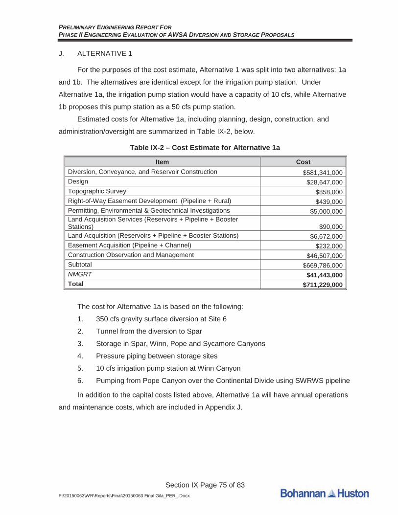
J. ALTERNATIVE 1
For the purposes of the cost estimate, Alternative 1 was split into two alternatives: 1a
and 1b. The alternatives are identical except for the irrigation pump station. Under
Alternative 1a, the irrigation pump station would have a capacity of 10 cfs, while Alternative
1b proposes this pump station as a 50 cfs pump station.
Estimated costs for Alternative 1a, including planning, design, construction, and
administration/oversight are summarized in Table IX-2, below.
Table IX-2 – Cost Estimate for Alternative 1a
Item CostDiversion, Conveyance, and Reservoir Construction $581,341,000Design $28,647,000Topographic Survey $858,000Right-of-Way Easement Development (Pipeline + Rural) $439,000Permitting, Environmental & Geotechnical Investigations $5,000,000Land Acquisition Services (Reservoirs + Pipeline + Booster Stations) $90,000Land Acquisition (Reservoirs + Pipeline + Booster Stations) $6,672,000Easement Acquisition (Pipeline + Channel) $232,000Construction Observation and Management $46,507,000Subtotal $669,786,000NMGRT $41,443,000Total $711,229,000
The cost for Alternative 1a is based on the following:
1. 350 cfs gravity surface diversion at Site 6
2. Tunnel from the diversion to Spar
3. Storage in Spar, Winn, Pope and Sycamore Canyons
4. Pressure piping between storage sites
5. 10 cfs irrigation pump station at Winn Canyon
6. Pumping from Pope Canyon over the Continental Divide using SWRWS pipeline
In addition to the capital costs listed above, Alternative 1a will have annual operations
and maintenance costs, which are included in Appendix J.

PRELIMINARY ENGINEERING REPORT FORPHASE II ENGINEERING EVALUATION OF AWSA DIVERSION AND STORAGE PROPOSALS
Section IX Page 76 of 83P:\20150063\WR\Reports\Final\20150063 Final Gila_PER_.Docx
Estimated costs for Alternative 1b, including planning, design, construction, and
administration/oversight are summarized in Table IX-3, below.
Table IX-3 – Cost Estimate for Alternative 1b
Item CostDiversion, Conveyance, and Reservoir Construction $583,522,000Design $28,786,000Topographic Survey $858,000Right-of-Way Easement Development (Pipeline + Rural) $439,000Permitting, Environmental & Geotechnical Investigations $5,000,000Land Acquisition Services (Reservoirs + Pipeline + Booster Stations) $90,000Land Acquisition (Reservoirs + Pipeline + Booster Stations) $6,672,000Easement Acquisition (Pipeline + Channel) $232,000Construction Observation and Management $46,682,000Subtotal $672,281,000NMGRT $41,597,000Total $713,878,000
The cost for Alternative 1b is based on the following:
1. 350 cfs gravity surface diversion at Site 6
2. Tunnel from the diversion to Spar
3. Storage in Spar, Winn, Pope and Sycamore Canyons
4. Pressure piping between storage sites
5. 50 cfs irrigation pump station at Winn Canyon
6. Pumping from Pope Canyon over the Continental Divide using SWRWS pipeline
In addition to the capital costs listed above, Alternative 1b will have annual operations
and maintenance costs, which are included in Appendix J.

PRELIMINARY ENGINEERING REPORT FORPHASE II ENGINEERING EVALUATION OF AWSA DIVERSION AND STORAGE PROPOSALS
Section IX Page 77 of 83P:\20150063\WR\Reports\Final\20150063 Final Gila_PER_.Docx
K. ALTERNATIVE 2
For the purposes of the cost estimate, Alternative 2 was split into two alternatives: 2a
and 2b. The alternatives are identical except for the irrigation pump station. Under
Alternative 2a, the irrigation pump station would have a capacity of 10 cfs, while Alternative
2b proposes this pump station as a 50 cfs pump station.
Estimated costs for Alternative 2a, including planning, design, construction, and
administration/oversight are summarized in Table IX-4, below.
Table IX-4 – Cost Estimate for Alternative 2a
Item CostDiversion, Conveyance, and Reservoir Construction $604,438,000Design $31,881,000Topographic Survey $858,000Right-of-Way Easement Development (Pipeline + Rural) $439,000Permitting, Environmental & Geotechnical Investigations $5,000,000Land Acquisition Services (Reservoirs + Pipeline + Booster Stations) $90,000Land Acquisition (Reservoirs + Pipeline + Booster Stations) $6,672,000Easement Acquisition (Pipeline) $232,000Construction Observation and Management $48,355,000Subtotal $697,965,000NMGRT $43,187,000Total $741,152,000
The cost for Alternative 2a is based on the following:
1. 150 cfs gravity subsurface diversion between Turkey Creek and Site 6
2. 200 cfs gravity surface diversion at Site 6
3. Tunnel from the diversion to Spar
4. Storage in Spar, Winn, Pope and Sycamore Canyons
5. Pressure piping between storage sites
6. 10 cfs irrigation pump station at Winn Canyon
7. Pumping from Pope Canyon over the Continental Divide using SWRWS pipeline
In addition to the capital costs listed above, Alternative 2a will have annual operations
and maintenance costs, which are included in Appendix J.
PRELIMINARY ENGINEERING REPORT FORPHASE II ENGINEERING EVALUATION OF AWSA DIVERSION AND STORAGE PROPOSALS
Section IX Page 78 of 83P:\20150063\WR\Reports\Final\20150063 Final Gila_PER_.Docx
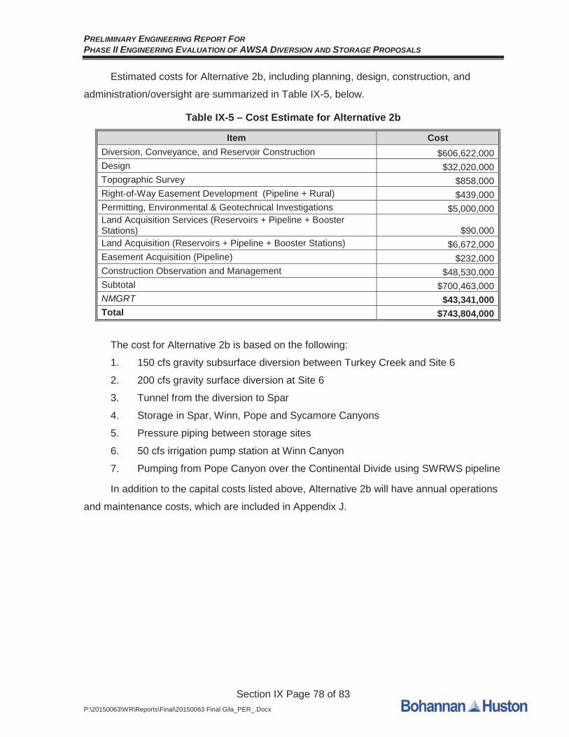
Estimated costs for Alternative 2b, including planning, design, construction, and
administration/oversight are summarized in Table IX-5, below.
Table IX-5 – Cost Estimate for Alternative 2b
Item CostDiversion, Conveyance, and Reservoir Construction $606,622,000Design $32,020,000Topographic Survey $858,000Right-of-Way Easement Development (Pipeline + Rural) $439,000Permitting, Environmental & Geotechnical Investigations $5,000,000Land Acquisition Services (Reservoirs + Pipeline + Booster Stations) $90,000Land Acquisition (Reservoirs + Pipeline + Booster Stations) $6,672,000Easement Acquisition (Pipeline) $232,000Construction Observation and Management $48,530,000Subtotal $700,463,000NMGRT $43,341,000Total $743,804,000
The cost for Alternative 2b is based on the following:
1. 150 cfs gravity subsurface diversion between Turkey Creek and Site 6
2. 200 cfs gravity surface diversion at Site 6
3. Tunnel from the diversion to Spar
4. Storage in Spar, Winn, Pope and Sycamore Canyons
5. Pressure piping between storage sites
6. 50 cfs irrigation pump station at Winn Canyon
7. Pumping from Pope Canyon over the Continental Divide using SWRWS pipeline
In addition to the capital costs listed above, Alternative 2b will have annual operations
and maintenance costs, which are included in Appendix J.
PRELIMINARY ENGINEERING REPORT FORPHASE II ENGINEERING EVALUATION OF AWSA DIVERSION AND STORAGE PROPOSALS
Section IX Page 79 of 83P:\20150063\WR\Reports\Final\20150063 Final Gila_PER_.Docx
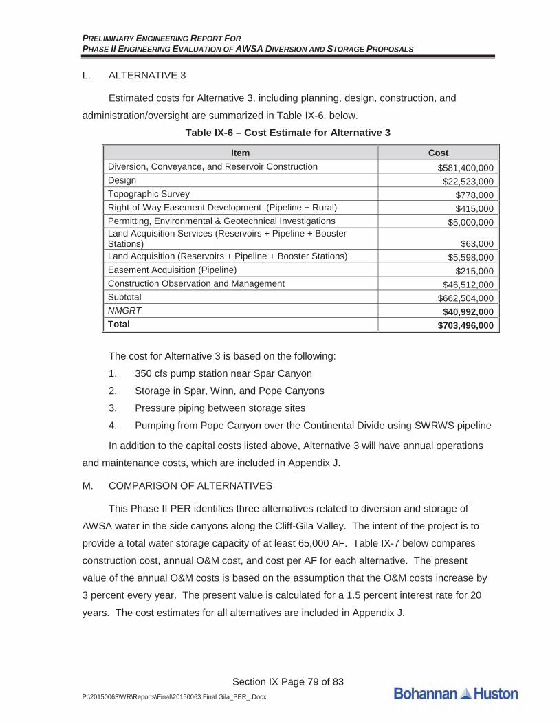
L. ALTERNATIVE 3
Estimated costs for Alternative 3, including planning, design, construction, and
administration/oversight are summarized in Table IX-6, below.
Table IX-6 – Cost Estimate for Alternative 3
Item CostDiversion, Conveyance, and Reservoir Construction $581,400,000Design $22,523,000Topographic Survey $778,000Right-of-Way Easement Development (Pipeline + Rural) $415,000Permitting, Environmental & Geotechnical Investigations $5,000,000Land Acquisition Services (Reservoirs + Pipeline + Booster Stations) $63,000Land Acquisition (Reservoirs + Pipeline + Booster Stations) $5,598,000Easement Acquisition (Pipeline) $215,000Construction Observation and Management $46,512,000Subtotal $662,504,000NMGRT $40,992,000Total $703,496,000
The cost for Alternative 3 is based on the following:
1. 350 cfs pump station near Spar Canyon
2. Storage in Spar, Winn, and Pope Canyons
3. Pressure piping between storage sites
4. Pumping from Pope Canyon over the Continental Divide using SWRWS pipeline
In addition to the capital costs listed above, Alternative 3 will have annual operations
and maintenance costs, which are included in Appendix J.
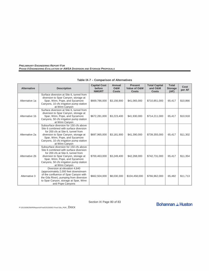
M. COMPARISON OF ALTERNATIVES
This Phase II PER identifies three alternatives related to diversion and storage of
AWSA water in the side canyons along the Cliff-Gila Valley. The intent of the project is to
provide a total water storage capacity of at least 65,000 AF. Table IX-7 below compares
construction cost, annual O&M cost, and cost per AF for each alternative. The present
value of the annual O&M costs is based on the assumption that the O&M costs increase by
3 percent every year. The present value is calculated for a 1.5 percent interest rate for 20
years. The cost estimates for all alternatives are included in Appendix J.
PRELIMINARY ENGINEERING REPORT FORPHASE II ENGINEERING EVALUATION OF AWSA DIVERSION AND STORAGE PROPOSALS
Section IX Page 80 of 83
P:\20150063\WR\Reports\Final\20150063 Final Gila_PER_.Docx
Table IX-7 – Comparison of Alternatives
Alternative DescriptionCapital Cost
before NMGRT
Annual O&M Costs
Present Value of O&M
Costs
Total Capital and O&M
Costs
Total Storage
(AF)Cost
per AF
Alternative 1a
Surface diversion at Site 6, tunnel from diversion to Spar Canyon, storage at
Spar, Winn, Pope, and Sycamore Canyons, 10 cfs irrigation pump station
at Winn Canyon
$669,786,000 $3,156,900 $41,065,000 $710,851,000 65,417 $10,866
Alternative 1b
Surface diversion at Site 6, tunnel from diversion to Spar Canyon, storage at
Spar, Winn, Pope, and Sycamore Canyons, 50 cfs irrigation pump station
at Winn Canyon
$672,281,000 $3,223,400 $41,930,000 $714,211,000 65,417 $10,918
Alternative 2a
Subsurface diversion for 150 cfs above Site 6 combined with surface diversion
for 200 cfs at Site 6, tunnel from diversion to Spar Canyon, storage at
Spar, Winn, Pope, and Sycamore Canyons, 10 cfs irrigation pump station
at Winn Canyon
$697,965,000 $3,181,900 $41,390,000 $739,355,000 65,417 $11,302
Alternative 2b
Subsurface diversion for 150 cfs above Site 6 combined with surface diversion
for 200 cfs at Site 6, tunnel from diversion to Spar Canyon, storage at
Spar, Winn, Pope, and Sycamore Canyons, 50 cfs irrigation pump station
at Winn Canyon
$700,463,000 $3,249,400 $42,268,000 $742,731,000 65,417 $11,354
Alternative 3
Diversion at elevation 4,640 (approximately 2,000 feet downstream of the confluence of Spar Canyon with the Gila River), pumping from diversion to Spar Canyon, storage at Spar, Winn
and Pope Canyons
$662,504,000 $8,030,300 $104,458,000 $766,962,000 65,482 $11,713

PRELIMINARY ENGINEERING REPORT FORPHASE II ENGINEERING EVALUATION OF AWSA DIVERSION AND STORAGE PROPOSALS
Section X Page 81 of 83P:\20150063\WR\Reports\Final\20150063 Final Gila_PER_.Docx
X. CONCLUSION AND NEXT STEPS
A. CONCLUSION
This PER recommends one new diversion location, refines analysis of potential
storage at Spar and Winn canyons, summarizes a new geomorphic review, an additional
geophysical/geotechnical field campaign, and analyzes pumping options and sediment
control measures. All of the alternatives meet the objective of the project to provide a total
water storage capacity of at least 65,000 AF to produce a safe yield of approximately 10,000
AFY.
During this phase of work, BHI was able to refine some of the assumptions that form
the basis for the cost estimates presented in Section IX above. The seismic survey at the
diversion site, as well as the bathymetric survey by Tetra Tech, provided more detailed
information on which to base the quantities and costs for the diversion structure. One major
difference between this analysis and the April 2014 PER is the recommendation for liners at
each of the reservoir sites. These liners and the associated earthwork increased the cost of
each dam appreciably. However, due to some refinement of the assumptions that form the
basis of the hydraulic profiles, the sizes, and therefore costs of some of the conveyances,
are smaller than what was proposed in the April 2014 PER.
BHI investigated the price of a radial collector well system on the Gila River. High-
level cost estimates for a radial collector well system on the Gila River were on the order of
$100,000,000. As discussed in Section V.A.2 above, more detailed investigation is required
if a radial collector well system remains a viable alternative on the Gila River. BHI has
developed the three alternatives for diversion, conveyance, and storage of Gila River water.
As described herein, each alternative meets the project objectives including the ability to
provide a total water storage capacity of at least 65,000 AF to produce a safe yield of
approximately 10,000 AFY with a minimum of 5,000 AF of storage near the top of the Cliff-
Gila valley (from which releases to mitigate drying and all of the farmland in the valley can
benefit).
B. NEXT STEPS
For this project to continue, the next steps would consist of more detailed
environmental, geological, and geotechnical investigations and conceptual design of a
selected Alternative. The environmental investigation should include field surveys,
jurisdictional determination, and permitting. Geological and geotechnical investigations

PRELIMINARY ENGINEERING REPORT FORPHASE II ENGINEERING EVALUATION OF AWSA DIVERSION AND STORAGE PROPOSALS
Section X Page 82 of 83P:\20150063\WR\Reports\Final\20150063 Final Gila_PER_.Docx
should include physical sampling of subsurface conditions at the reservoir sites and
diversion site in order to provide criteria for the conceptual design. The conceptual design
would refine the conveyances and storage from the appraisal level concepts presented in
this report. This would enable development of more certain project cost estimates for
budgeting and funding purposes.
Provided the environmental and geotechnical investigations and conceptual design do
not uncover any serious technical challenges to the viability of the project, the next steps
would be to secure permitting, easements, or land acquisition of the reservoir sites,
pipelines, and booster stations.
Once permitting, clearances and right-of-way or easements have been secured,
design survey and preliminary and final design can commence, followed by construction and
commissioning. The design and construction, while forming the bulk of the cost of the
project, will likely require less time in the schedule than the pre-design (investigations,
permits, and conceptual design) activities.

TourGila River, NMJ u n e 2 0 1 5
RJH Study
Value Engineering Study SWRWS Project November 2014
Solutions Engineering & Facilitating, Inc.
Final Report 1-1
EXECUTIVE SUMMARY This report contains the results of the Value Engineering Study of the Southwest Regional Water Supply (SWRWS) Project, proposed to the Interstate Stream Commission as part of the planning process under the 2004 Arizona Water Settlements Act (AWSA). The report is organized in a drill down format, that is, all items are presented first in summary format with increasing levels of detail as one delves (drills down) further into the report. This will allow the reader to easily obtain only the information he or she desires. The goals for this VE Study were to: review the AWSA water availability including the AWSA diversion model, review the BHI and the BOR appraisal-level designs including the preferred configuration of components, and recommend further studies and/or investigations. Areas not included in this VE Study were: ” quality control checks of the current appraisal level designs, review of the legal implication of the project, or independent cost estimate review of the current appraisal level designs. Technical data provided the VE Team included data from the BHI Phase II Draft Final Report dated September 12, 2014, Bureau of Reclamation Appraisal Level Report on the Arizona Water Settlements Act Tier-2 Proposals and other Diversion and Storage Configurations dated July 2014, plus multiple other reports and data. The VE Team consisted of eight very senior technical specialists plus an equally senior value engineering facilitator. The technical specialties included: constructability and costing; hydraulic structures and conveyance; environmental permitting; geomorphology and sediment transport; dams, reservoirs and geotechnical; electrical; tunneling; hydrology, water modeling and yield; and value engineering and life-cycle costing. The Value Engineering (VE) Team selected BHI’s Preferred Alternative No. 2 as the base case against which to measure their VE Proposals. Therefore, all of the proposals and supplemental recommendations are measured against this design concept. This Value Engineering (VE) Study generated thirteen (13) proposals and seventeen (17) supplemental recommendations. These proposals and supplemental recommendations are categorized by following technical areas: Diversion, Sedimentation, Conveyance, Storage/Reservoirs, Distribution and Diversion Model Review. For the purpose of this report, the Value Engineering Proposals are ideas that have the potential to save life-cycle costs, and Supplemental Recommendations are ideas that would improve the project, but don’t easily fit into either of the previous category. The first section of the report contains an executive summary of all the value engineering proposals, their estimated savings, and their ultimate disposition. To obtain the backup information about the VE Proposal, or the Review Board (ISC staff) Decision reasoning regarding the VE Proposal, the hyperlinks shown in the summary table can be used. The second section of the report contains a brief project background, the VE Study Team Members, and a brief description of the methodology used. The third section contains detailed information about each VE Proposal. These individual proposal analyses are also organized in a drill down manner. Section Four contains a summary of all the supplemental recommendations, and their ultimate disposition. As mentioned above, these are ideas that the Team thought would add value to the project but do not necessarily reduce life-cycle costs. This section is further subdivided into four sections: AWSA Water Availability, Recommendations for Added Value, Recommendations for Further ISC Study, and Notes to Designer. To obtain the backup information about the VE Supplemental Recommendations, or the Review Board Decision reasoning regarding the VE Supplemental Recommendations, the hyperlinks shown in the summary table can be used. Section Five contains ideas analyzed by the Team, but either failed because they were thought to not be technically viable and/or did not save life-cycle costs. Section Six contains functions analyzed by the VE Team. Section Seven contains all of the brainstorming ideas ideated by the Team both prior to and during the workshop. Section Eight documents the ultimate disposition of the Team’s Proposals and Supplemental Recommendations as made by the Review Board. A summary of findings of the VE Team are as follows: AWSA Water Availability and Yield
Value Engineering Study SWRWS Project November 2014
Solutions Engineering & Facilitating, Inc.
Final Report 1-2
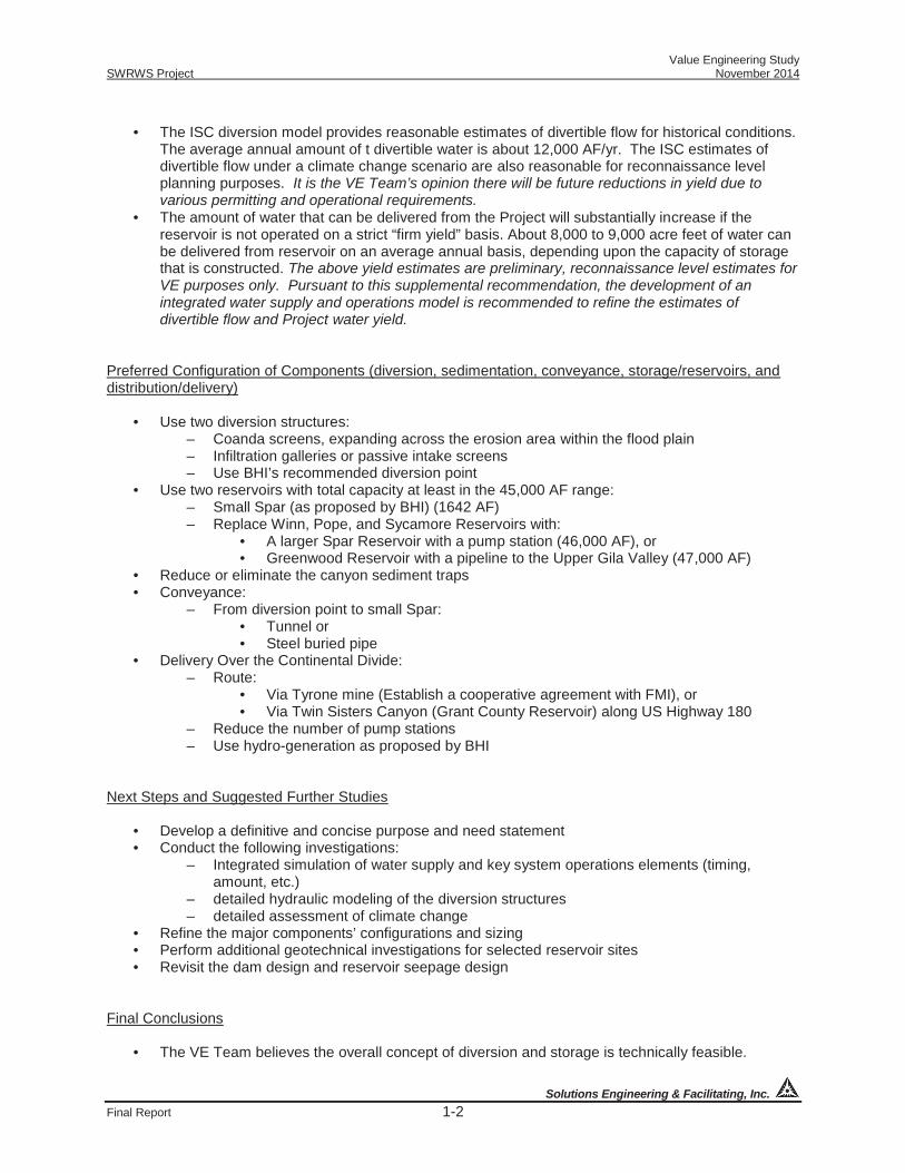
• The ISC diversion model provides reasonable estimates of divertible flow for historical conditions.
The average annual amount of t divertible water is about 12,000 AF/yr. The ISC estimates of divertible flow under a climate change scenario are also reasonable for reconnaissance level planning purposes. It is the VE Team’s opinion there will be future reductions in yield due to various permitting and operational requirements.
• The amount of water that can be delivered from the Project will substantially increase if the reservoir is not operated on a strict “firm yield” basis. About 8,000 to 9,000 acre feet of water can be delivered from reservoir on an average annual basis, depending upon the capacity of storage that is constructed. The above yield estimates are preliminary, reconnaissance level estimates for VE purposes only. Pursuant to this supplemental recommendation, the development of an integrated water supply and operations model is recommended to refine the estimates of divertible flow and Project water yield.
Preferred Configuration of Components (diversion, sedimentation, conveyance, storage/reservoirs, and distribution/delivery)
• Use two diversion structures: – Coanda screens, expanding across the erosion area within the flood plain – Infiltration galleries or passive intake screens – Use BHI’s recommended diversion point
• Use two reservoirs with total capacity at least in the 45,000 AF range: – Small Spar (as proposed by BHI) (1642 AF) – Replace Winn, Pope, and Sycamore Reservoirs with:
• A larger Spar Reservoir with a pump station (46,000 AF), or • Greenwood Reservoir with a pipeline to the Upper Gila Valley (47,000 AF)
• Reduce or eliminate the canyon sediment traps • Conveyance:
– From diversion point to small Spar: • Tunnel or • Steel buried pipe
• Delivery Over the Continental Divide: – Route:
• Via Tyrone mine (Establish a cooperative agreement with FMI), or • Via Twin Sisters Canyon (Grant County Reservoir) along US Highway 180
– Reduce the number of pump stations – Use hydro-generation as proposed by BHI
Next Steps and Suggested Further Studies
• Develop a definitive and concise purpose and need statement • Conduct the following investigations:
– Integrated simulation of water supply and key system operations elements (timing, amount, etc.)
– detailed hydraulic modeling of the diversion structures – detailed assessment of climate change
• Refine the major components’ configurations and sizing • Perform additional geotechnical investigations for selected reservoir sites • Revisit the dam design and reservoir seepage design
Final Conclusions
• The VE Team believes the overall concept of diversion and storage is technically feasible.
Value Engineering Study SWRWS Project November 2014
Solutions Engineering & Facilitating, Inc.
Final Report 1-3
• The VE Team feels permitting will be prolonged and challenging. • Reusable return flows and tributary runoffs should be recaptured and/or exchanged.

Value Engineering Study SWRWS Project November 2014
Solutions Engineering & Facilitating, Inc.
Final Report 1-4
VE PROPOSAL SUMMARY TABLE
Note: To obtain the backup information about the VE Proposal or the Review Board Decision reasoning regarding the VE Proposal, the hyperlinks shown in the summary table can be used.
PROPOSAL
NO. VE PROPOSAL DESCRIPTION REVIEW BOARD DECISIONS PAGE NO.
P01-003 Collect, use, and account for surface flows from Gila River tributaries that flow into the system’s water storage reservoirs. Initial Est. Savings: ($20,000) Future Est. Savings: $1,580,000 Total Est. Savings: $1,560,000
TABLE Attractive idea and could be very helpful, but the legal issues are still undecided. The details would have to be worked out in accordance with Sub-term 1.10 of Exhibit 2.47 of Consumptive Use and Forbearance Agreement (CUFA). There are also other laws to which NM must adhere. The NM Office of the State Engineer (OSE) requires that dams release flood runoff within 96 hours.
3-1
P01-009 Use steel pipe to convey diverted water from the Coanda intake screens only at the BHI diversion structure through buried and elevated alignment along the Gila River for discharges into the Spar Reservoir. Initial Est. Savings: $5,200,000 Future Est. Savings: $0,000 Total Est. Savings: $5,200,000
DECLINE Due to environmental concerns and the higher risk of environmental disturbance. In addition, it is not aesthetically desired. It also requires maintenance access road. Construction access would be challenging.
3-6
P01-011 Include water conservation measures as a component of the project. Initial Est. Savings: $0,000 Future Est. Savings: $2,864,430 Total Est. Savings: $2,864,430
ACCEPT Water conservation measures will be included as required by OSE. Those measures are already being considered separately. It would be helpful to know whether or not the savings calculation takes into account the loss of return flows from the fields.
3-10
P01-013 Consolidate Pope and Sycamore reservoirs into one larger reservoir in Greenwood canyon. Initial Est. Savings: $70,000,000 Future Est. Savings: $0,000 Total Est. Savings: $70,000,000
ACCEPT Consolidate Pope and Sycamore reservoirs into one larger reservoir in Greenwood canyon.
3-13
P01-014 Eliminate Winn Reservoir and add a second reservoir in Spar Canyon. Initial Est. Savings: $17,000,000 Future Est. Savings: $0,000 Total Est. Savings: $17,000,000
ACCEPT 3-16
P01-015 Optimize the required number and size of pumping stations for Deming delivery flow (SWRWS) requirements. Initial Est. Savings: $1,650,000 Future Est. Savings: $0,000 Total Est. Savings: $1,650,000
ACCEPT 3-19

Value Engineering Study SWRWS Project November 2014
Solutions Engineering & Facilitating, Inc.
Final Report 1-5
PROPOSAL NO. VE PROPOSAL DESCRIPTION REVIEW BOARD DECISIONS PAGE
NO. P01-031 Use passive intake screens to replace
the infiltration galleries in combination with Coanda screens at the BHI Gila River diversion point intake structure. Initial Est. Savings: $13,600,000 Future Est. Savings: $100,000 Total Est. Savings: $13,700,000
TABLE This proposal appears to have a greater probability of long-term success than the infiltration gallery. In addition, the projected savings are large. However, USGS data indicates that when the flow is less than 50 cfs, the depth of the water at the gage is less than 5” above 4654’. Looking at the Tetratech bathymetric sketches, these might not be covered during low flows. Finally, security issues need to be addressed.
3-20
P01-048 Construct channels to allow tributary sediment to bypass the storage reservoirs. Initial Est. Savings: $6,000,000 Future Est. Savings: ($1,700,000) Total Est. Savings: $4,300,000
DECLINE Although this seems preferable to BHI’s stormwater detention facilities, sediment removal dams have been in place and to good effect for decades. 12 of the tributaries along the Gila have sediment/flood control dams. Winn Canyon is the largest, and Sycamore has a check dam. But there are no such dams on either Spar or Greenwood.
3-27
P01-055 Modify the feature of the dam discharge to allow greater temperature control of releases. Initial Est. Savings: $0,000 Future Est. Savings: $0,000 Total Est. Savings: $0,000
ACCEPT This will likely be required in order to protect aquatic species.
3-32
P01-060 Use existing electrical infrastructure to feed the low horsepower pumps for Winn Reservoir. Initial Est. Savings: Not quantified Future Est. Savings: Not quantified Total Est. Savings: Not quantified
ACCEPT WITH MODIFICATIONS Although the costs/savings are unknown, it seems that the existing electrical infrastructure could be used, especially if there is a pump station for Larger Spar (P01-014), or Greenwood (P01-013). This could also be combined with SR01-030 to use FMI’s power infrastructure.
3-35
P01-061 Use 12.47kV or 13.8kV rather than 4.16kV for the large pump motors. Initial Est. Savings: $2,000,000 Future Est. Savings: $0,000 Total Est. Savings: $2,000,000
ACCEPT Due to savings.
3-37
P01-062 Connect into PNM's 115kV source rather than the 69kV source voltage. Initial Est. Savings: Not Calculated Future Est. Savings: Not Calculated Total Est. Savings: Not Calculated
TABLE Costs/savings are unknown. Perhaps this could be studied further and some cost estimates generated.
3-39
Value Engineering Study SWRWS Project November 2014
Solutions Engineering & Facilitating, Inc.
Final Report 1-6
PROPOSAL NO. VE PROPOSAL DESCRIPTION REVIEW BOARD DECISIONS PAGE
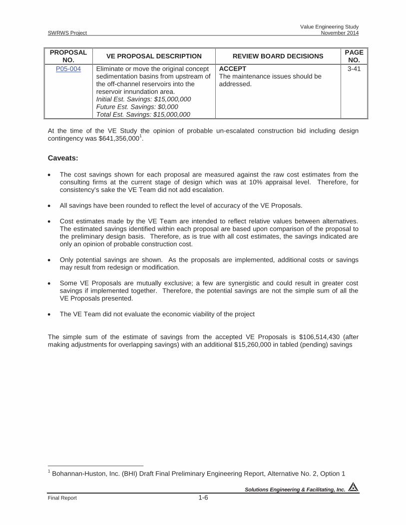
NO. P05-004 Eliminate or move the original concept
sedimentation basins from upstream of the off-channel reservoirs into the reservoir innundation area. Initial Est. Savings: $15,000,000 Future Est. Savings: $0,000 Total Est. Savings: $15,000,000
ACCEPT The maintenance issues should be addressed.
3-41
At the time of the VE Study the opinion of probable un-escalated construction bid including design contingency was $641,356,0001.
Caveats: The cost savings shown for each proposal are measured against the raw cost estimates from the
consulting firms at the current stage of design which was at 10% appraisal level. Therefore, for consistency’s sake the VE Team did not add escalation.
All savings have been rounded to reflect the level of accuracy of the VE Proposals.
Cost estimates made by the VE Team are intended to reflect relative values between alternatives.
The estimated savings identified within each proposal are based upon comparison of the proposal to the preliminary design basis. Therefore, as is true with all cost estimates, the savings indicated are only an opinion of probable construction cost.
Only potential savings are shown. As the proposals are implemented, additional costs or savings
may result from redesign or modification. Some VE Proposals are mutually exclusive; a few are synergistic and could result in greater cost
savings if implemented together. Therefore, the potential savings are not the simple sum of all the VE Proposals presented.
The VE Team did not evaluate the economic viability of the project
The simple sum of the estimate of savings from the accepted VE Proposals is $106,514,430 (after making adjustments for overlapping savings) with an additional $15,260,000 in tabled (pending) savings
1 Bohannan-Huston, Inc. (BHI) Draft Final Preliminary Engineering Report, Alternative No. 2, Option 1
Value Engineering Study SWRWS Project November 2014
Solutions Engineering & Facilitating, Inc.
Final Report 4-1
The following ideas were generated by the VE Team and thought to have considerable merit. These ideas are thought to offer improvements, but either the economics were not calculable or the idea could not be developed because of insufficient information. The VE Team suggests that these recommendations be carefully reviewed and given as much thought and effort as the formal VE Proposals.
SUPPLEMENTAL RECOMMENDATIONS SUMMARY TABLE
PROPOSAL NO. VE PROPOSAL DESCRIPTION REVIEW BOARD COMMENTS PAGE
NO. AWSA Water Availability
SR01-064 Review and evaluate divertible water supply and project yield.
ACCEPT It is necessary.
4-5
Recommendations for Added Value SR01-012 Implement a staged project
development plan that provides an initial Gila diversion and an initial or base level of storage, selected and designed to facilitate staged design and construction that is based on optimized supply potential versus current and projected demand.
ACCEPT Given the time involved and the financial resources, this appears to be a necessity.
4-12
SR01-026 Develop project objectives and operational criteria for diversion-storage alternatives.
ACCEPT 4-14
SR01-006 Divert Gila River return flow by exchange or recapture.
TABLE This is probably challenging due to CUFA constraints and/or non-point return flows. In addition, returns are needed by downstream users. If NM can demonstrate return flow, it could probably just negotiate a credit and divert water under CUFA terms. There are also questions regarding how this affects water rights and enforcement, and how it takes into account the excess water diverted to provide adequate pressure head.
4-16
SR01-019 Add additional erosion protection at the proposed diversion structures to prevent flanking of the structures by riverine erosion during large floods.
ACCEPT This would apparently be necessary for the project to continually accomplish its purpose.
4-19
SR01-020 Add an ALERT/SCADA system to enable opitimized system operation and accounting of water flows into and out of the project.
ACCEPT NM may be able to partially fund this through (vii)(D)(2)Section 107 of the AWSA.
4-23
SR01-027 Align the technical (engineering), NEPA, and Section 404 alternatives development and evaluation processes.
ACCEPT This would appear to save a great deal of time and effort.
4-27
SR01-037 Develop purpose and need (P&N) statement as foundation for alternatives development and evaluation.
ACCEPT This will be formulated as part of NEPA, if NM chooses to develop the AWSA water.
4-30

Value Engineering Study SWRWS Project November 2014
Solutions Engineering & Facilitating, Inc.
Final Report 4-2
PROPOSAL NO. VE PROPOSAL DESCRIPTION REVIEW BOARD COMMENTS PAGE
NO. SR01-030 Develop and/or expand and use the
existing Freeport-McMoRan (FMI) Tyrone (Bill Evans Lake) facilities for water storage, pumping, and pipeline conveyance for Mimbres basin water requirements.
TABLE FMI’s facilities are designed for the uses at the mine and for diversion of lower flows than those of AWSA. In addition, Bill Evans Lake likely does not have much additional capacity. Bill Evans Lake accepts only crystal clear, sediment free water. This might be solely to protect their pump impellers. They divert at low flows, whereas under the SWRWS project, sediment-laden water needs to be diverted at high flows. However, FMI’s existing power infrastructure could be used to serve pump stations for the reservoirs (e.g. Greenwood). In addition, the route along Mangas Creek through Tyrone Mine could be used for SWRWS pipeline to Deming.
4-32
SR02-004 Construct a low head dam at the BHI diversion point on the Gila River comprised of concrete fixed weir wall, piling cutoff walls, and sediment bypass sluiceway to provide sufficient water depth, clean water, and adequate supplies of water diversions into the intake screen area for conveyance to Spar Reservoir.
DECLINE This seems more “invasive” of the channel than the Coanda screen, and the aesthetic appeal of the area might be lost. It is accepted, however, that something needs to be done to prevent flanking across the floodplain (SR01-019).
4-35
SR04-002 Do not provide a separate pipe or cast-in-place concrete lining for the tunnel.
TABLE There needs to be additional geological/geotechnical information and research.
4-37
Recommendations for Further Study by the ISC SR01-005 Establish a target delivery amount
and location(s) for environmental flow augmentation.
TABLE This would have to be done at some point. However, it would likely be done when consulting with the US Fish and Wildlife Service and during the NEPA process, if NM chooses to pursue this project.
4-40
SR01-052 Develop an integrated ground water/surface water model to help define operational parameters, to monitor the effectiveness of environmental bypass flows, and to account for non-point discharges of return flows into the Gila River that could be recaptured and reused.
ACCEPT This could likely be built upon the model developed by SSPA.
4-42

Value Engineering Study SWRWS Project November 2014
Solutions Engineering & Facilitating, Inc.
Final Report 4-3
PROPOSAL NO. VE PROPOSAL DESCRIPTION REVIEW BOARD COMMENTS PAGE
NO. SR01-007 Considering a) BHI’s single-liner lined
reservoir, homogenous dam over and an unimproved alluvial foundation, and b) Reclamation’s zoned earthfill over a cutoff foundation without reservoir seepage control, additional alternative designs should be considered that robustly address dam safety and seepage management.
ACCEPT Safety and seepage would need additional attention in next design phase.
4-44
SR01-050 Perform additional detailed hydraulic modeling of the proposed diversion structure to assess its performance under a wider range of likely flow rate and sedimentation conditions.
ACCEPT This is necessary in the next design phase. Perhaps even a 3D scale model could be constructed in a laboratory.
4-47
SR01-021 Perform a Monte Carlo simulation of key system operations elements relating to the capture and delivery of AWSA waters to further demonstrate project feasility, identify project vulnerabilities, and identify potential improvements in system performance.
ACCEPT This could be done In lieu of modifying the ISC CUFA model for additional climate variability (SR01-049).
4-49
SR01-049 Make the climate change impact analysis in the ISC water availability model more robust by including likely changes in seasonal flow rates due to climate change.
TABLE The seasonal flow rates have already been considered in the ISC model. This could be more expanded later.
4-52
SR01-035 Pump water from San Carlos Reservoir back to southwest New Mexico.
DECLINE With the AWSA, NM already has terms negotiated and ratified. Legal and physical aspects of this proposal are really challenging.
4-55

TourGila River, NMJ u n e 2 0 1 5
Thank you!
Contact Information
Bureau of Reclamation Vivian Gonzales, Study Manager [email protected] 623-773-6416
Jeff Riley, P.E., Engineering Division Chief [email protected] 623-773-6457
New Mexico Interstate Stream Commission Deborah Dixon, P.E., Director [email protected] 505-827-6160
Craig Roepke, Gila River Bureau Chief [email protected] 505-827-6160