toward adaptation toward adaptation to alarming water ... · integrated observation for sustainable...
TRANSCRIPT

Summary of the Session onSummary of the Session onSummary of the Session onEARTH OBSERVATIONS EARTH OBSERVATIONS EARTH OBSERVATIONS
FOR SUSTAINABLE WATER MANAGEMENTFOR SUSTAINABLE WATER MANAGEMENTFOR SUSTAINABLE WATER MANAGEMENT
GEOSS Symposium on Integrated Observation for Sustainable Development in the Asia-Pacific Region
(GEOSS AP Symposium)At Mirai-kan in Tokyo, Japan
April 14-16, 2008
Toward Adaptation Toward Adaptation Toward Adaptation to Alarming Water Cycle Variations to Alarming Water Cycle Variations to Alarming Water Cycle Variations
under under under the the the Climate ChangeClimate ChangeClimate Change

Drought and Water Scarcity
Floods and Land Slides
Water Pollution and
Ecosystem Degradation
Climate Change Impacts on Water Cycle

Extreme Weather Events in late 20th century, human contribution, and future trend
> 90%
> 66%
> 66%

Monsoon Rainfallincrease or decrease ?
Change in the mean annual range of precipitation: ]1976 to 2003 minus 1948 to 1975 periods (mm per day).

Short Lecture for Scientific Understandings and PredictionsDevelopment of a daily grid precipitation analysis dataset over Asia by A. YatagaiWater Cycle Projection in Asia by Super-High-Resolution Climate Model by A. Kitoh

Data Collection
Blue:GTSBlack:Pre-compiled datasetRed:Individual collection

V07076030 stations
V04091400 stations
GTS920 station
Input more rain gauges

Short Lecture for Scientific Understandings and PredictionsDevelopment of a daily grid precipitation analysis dataset over Asia by A. YatagaiWater Cycle Projection in Asia by Super-High-Resolution Climate Model by A. Kitoh

JJA precipitation climatology
EAclim
20km GCM180km GCMTRMM3A25
CMAP GPCP

JMAJMATyphoon track and intensity: 60km vs 20km
60km mesh model
20km mesh model
60-km model forecasts shallower central pressures and weaker maximum winds. 20-km model represents typhoon development closer to the observations.

Changes in annual streamflow
Streamflow increases in most of rivers in East Asia and South Asia, but decreases in Southeast Asia, western Asia and the Mediteranean region

Short Lecture for Scientific Understandings and PredictionsDevelopment of a daily grid precipitation analysis dataset over Asia by A. YatagaiWater Cycle Projection in Asia by Super-High-Resolution Climate Model by A. Kitoh
Short reports on "What is happening in the water cycle and water resources management under possible (ongoing) impacts of the climate change?" Bangladesh/Bhutan/India/Indonesia/Japan/Korea/Mongolia/Nepal/Pakistan/Philippines/Sri Lanka/Thailand/Uzbekistan/Vietnam
Short reports on "What is on-going and/or planned?IGWCO/APN/UNU/ICHARM/Pacific Region Drought Initiative/Sentinel Asia /HARIMAU/AWCI

•documenting the variationsLocal To integrate local -global data sets and information and analyze
MRI/GCM20, K-GEO/27km RCM•documenting the societal issues
•summarizing the on-going and planed adaptations
•realizing end-to-end approaches
•providing usable information for effective adaptations
•building capacity

Numerical Climate Prediction Model
Flood/Inundations→Evacuation
Instruction
Satellite River Management data Reference Site Data
GIS/Basin Info.
Support of data interoperability
Ontology of
dictionary
Ontology of
Geographic inform
ation Water ResourceManagement
Flood PredictionHeavy RainfallPrediction
Satellite DataAssimilation Distributed
Hydrological ModelOperation
Optimization

•documenting the variationsLocal To integrate local -global data sets and information and analyze Monsoonal Region To compile nation’s reports and datasets and analyze•documenting the societal issues Daily Rain Gauge Grid Products
•summarizing the on-going and planed adaptations
•realizing end-to-end approaches
•providing usable information for effective adaptations
•building capacity

•documenting the variationsLocal To integrate local -global data sets and information and analyze Monsoonal Region To compile nation’s reports and datasets and analyze•documenting the societal issuesTo compile nation’s reportsTo compare and identify of common and unique issues
•summarizing the on-going and planed adaptationsTo compile nation’s reportsTo promote to exchange ideas, experiences and knowledge
•realizing end-to-end approaches
•providing usable information for effective adaptations
•building capacity

BangladeshBangladesh
VietnamVietnam
LaosLaos
PhilippinesPhilippines
MongoliaMongolia
Sri LankaSri Lanka
PakistanPakistan
IndonesiaIndonesia
MyanmarMyanmar
CambodiaCambodia
ThailandThailand
JapanJapan
KoreaKorea
BhutaBhutann
IndiaIndia
UzbekistanUzbekistan
MalaysiaMalaysia
ChinaChinaNepalNepal
GEOSS Asian Water Cycle Initiative (AWCI)17 River Basins for Initial Demonstration

•documenting the variationsLocal To integrate local -global data sets and information and analyze Monsoonal Region To compile nation’s reports and datasets and analyze•documenting the societal issuesTo compile nation’s reportsTo compare and identify of common and unique issues
•summarizing the on-going and planed adaptations
•realizing end-to-end approaches
To compile nation’s reports
To collaborate with GEO Tasks and international organizations and projects..
To promote to exchange ideas, experiences and knowledge
•providing usable information for effective adaptations
•building capacity
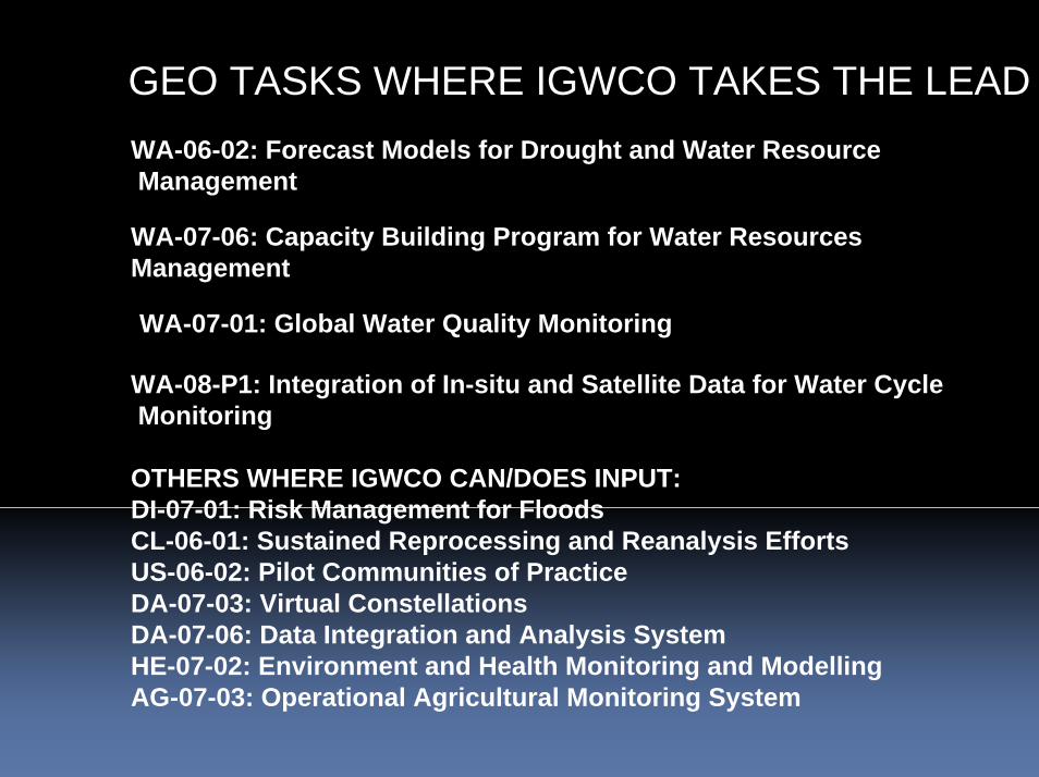
GEO TASKS WHERE IGWCO TAKES THE LEADWA-06-02: Forecast Models for Drought and Water ResourceManagement
WA-07-06: Capacity Building Program for Water ResourcesManagement
WA-07-01: Global Water Quality Monitoring
WA-08-P1: Integration of In-situ and Satellite Data for Water CycleMonitoring
OTHERS WHERE IGWCO CAN/DOES INPUT:DI-07-01: Risk Management for FloodsCL-06-01: Sustained Reprocessing and Reanalysis EffortsUS-06-02: Pilot Communities of PracticeDA-07-03: Virtual ConstellationsDA-07-06: Data Integration and Analysis SystemHE-07-02: Environment and Health Monitoring and ModellingAG-07-03: Operational Agricultural Monitoring System

In – s itu r iv er d is c ha rg e
N H S s ,G R D C /G T N -R
W H Y C O S P r o jec ts
N H S s
L a ke an d r e se rv o ir le ve ls
H Y D R O L A R E
G r o u n d w a te r
IG R A C
S a te ll iteo b s er va tio ns
•R a d ar a lt im e try•G r a v im e tr ic sa te ll ite in fo r m a tio n•S M O S
E S A , o th e r s pa cea g e nc ie s
G L O B A LT E R R E S T IA L
N E T W O R K– H Y D R O L O G Y
(G T N – H )
W a te r q u a lityG E M S /W a te r
P r is tine rive rsN H S s , W M O /C H y
S n o w c o ve r , g la c ie rs
N S ID C W G M S /G T N G
S o il m o is tu re
S M O S
C o a s ta l zo nea n d oc ea n
o b s er va tio ns
S y n o p tic w e a the ro b s er va tio ns
N M S s , G P C C
P h a s e I P h a s e II P h a s e III
O th e r fu tur e ne tw o rk s
Phased Linkage of Networks with HARON

IGWCO ACTIVITY CLIMATE IMPACT EXISTING
PRECIPITATION YES – FOR EXTREMES AND PATTERN SHIFTS
INTEGRATED PRODUCT DEVELOPMENT
SOIL MOSITURE YES – SHIFTS OF PATTERNS AND SEASONALITY
NETWORK DESIGN CONSIDERATION
RUNOFF YES – SEASONALITY AND PEAK FLOWS CHANGES
MONITOR CHANGES IN AMOUNT & SEASONALITY
GROUNDWATER YES – RECHARGE ISSUES MEASURE RESPONSES TOMEANS AND EXTREMES
WATER QUALITY YES – LOW FLOWS ARE A CRITICAL ISSUE
PROJECT OPPORTUNITY FOR LOW FLOWS
INDICATORS COMMUNICATION OF THE ISSUE
ASSESSMENT IN E2E ACTIVITY (DROUGHT)
CEOP BETTER UNDERSTANDING AND PREDICTIONS
CEOP BRINGS DATA FOR MODEL DEVELOPMENT
CAPACITY BUILDING MANAGEMENT AND ADAPTATION OPPORTUNITIES
CB EFFORTS FOCUS ON ABILITY TO ACCESS/ USE DATA

•documenting the variationsLocal To integrate local -global data sets and information and analyze Monsoonal Region To compile nation’s reports and datasets and analyze•documenting the societal issuesTo compile nation’s reportsTo compare and identify of common and unique issues
•summarizing the on-going and planed adaptations
•realizing end-to-end approaches
To compile nation’s reports
To collaborate with GEO Tasks and interna 1tional organizations and projects..
To promote to exchange ideas, experiences and knowledge
To establish and activate data provider-user cooperation
•providing usable information for effective adaptationsTo establish and activate data provider-user cooperation
•building capacity

APN Member Countries
Pacific Island Countries and Singapore are approved countries whose scientists are eligible to receive funding under APN awards.
AustraliaBangladeshCambodiaChinaFijiIndiaIndonesiaJapanLao PDRMalaysiaMongoliaNepal
New ZealandPakistanPhilippinesRepublic of KoreaRussian FederationSri LankaThailandUnited Statesof AmericaViet Nam

UNU POPs Analytical Capacity Development Project
UNU POPs Monitoring Project
Japan
Viet Nam
Malaysia
PhilippinesThailand
Indonesia
Pakistan
India
ChinaRepublic of Korea
SingaporeSince 1996Since 1999Since 2005

October 200533rd UNESCO General
ConferenceJPN proposal accredited by 191 countries
ICHARMInternational Centre for Water Hazard and Risk
Managementunder the auspices of UNESCO
hosted by PWRI, Tsukuba
3 March, 2006 in Paris
6 March, 2006at Tsukuba

Group on Earth Observations2007 Plenary and Ministerial Summit
~40 people from 19 countries
- Argentina- Australia- Austria- Belgium- Botswana- Canada- France- Germany- Honduras- Japan
Introduction - Mark Myers, Director, USGS
North American Drought Monitor and NIDIS- Jay Lawrimore, NOAA/NCDC
FEWS NET- Tamuka Magadzire, FEWS NET Regional Scientist for Southern Africa
Drought Management Center for Southeastern Europe-Silvo Zlebir, Director, Environmental Agency of the Republic of Slovenia
SERVIR- Carrie Stokes, USAID
Drought Side Meeting • 29-Nov-2007
- Kenya- Korea - Netherlands- Norway- Panama- Slovenia- South Africa- United Kingdom- USA
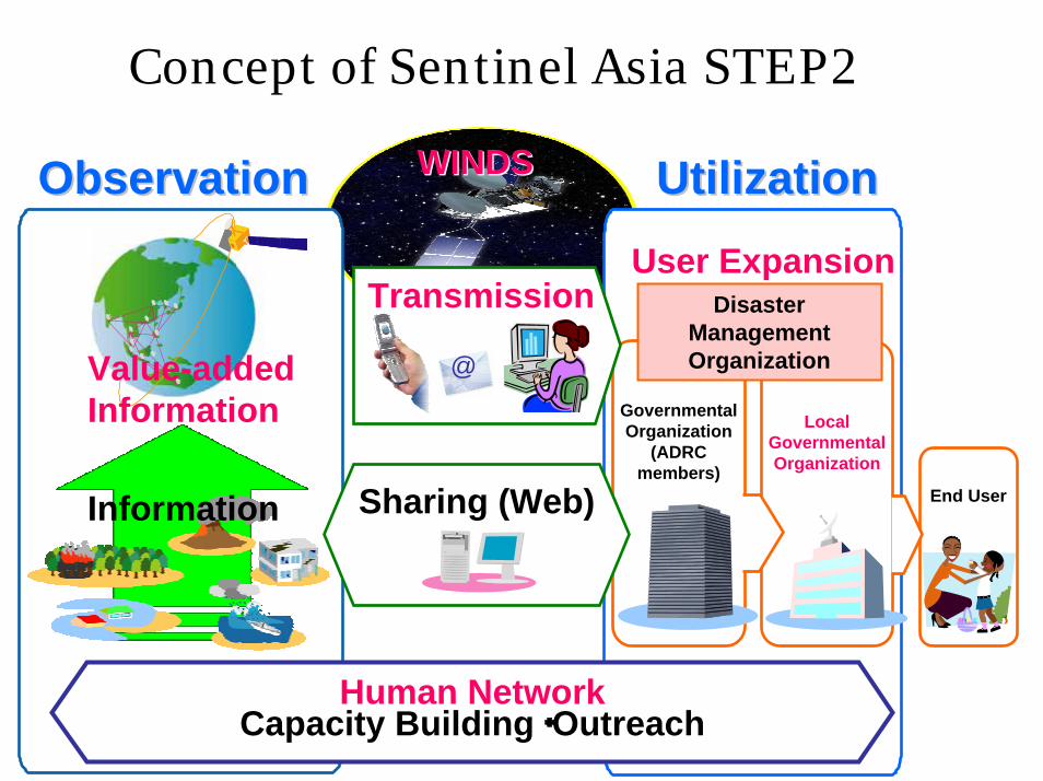
Concept of Sentinel Asia STEP2
ObservationObservationObservation UtilizationUtilizationUtilization
End User
Local Governmental Organization
Governmental Organization
(ADRC members)
User ExpansionTransmission
@
Disaster ManagementOrganization
Human NetworkCapacity Building・Outreach
Sharing (Web)Information
WINDSWINDS
Value-added Information

Japan EOS Promotion Program (JEPP) + Indonesian Research/Technology Grant
Hydrometeorological Array for ISV-Monsoon Automonitoring (HARIMAU)
http://www.jamstec.go.jp/iorgc/harimau/[email protected]
2008

GEOSSAsian Water Cycle Initiative
(AWCI)
1st GEOSS AP Symposium, Tokyo, Jan. 2007
1st Asian Water Cycle Symposium, Tokyo, Nov. 2005
1st Capacity Building Workshop, Sep. 2006
1st Task Team Meeting, Bangkok, Sep. 2006
2nd Asian Water Cycle Symposium, Tokyo, Jan. 2007
1st International Coordination Group Meeting, Bali, Sep. 2007
3rd Asian Water Cycle Symposium, Beppu, Dec. 2007
To promote integrated water resources management by making usable information
from GEOSS, for addressing the common water-related
problems in Asia.
Uniqueness・A River Basin of Each Country・Observation Convergence・Interoperability Arrangement・Data Integration・Open Data & Source Policies・Capacity Building・Early Achievements

•documenting the variationsLocal To integrate local -global data sets and information and analyze Monsoonal Region To compile nation’s reports and datasets and analyze•documenting the societal issuesTo compile nation’s reportsTo compare and identify of common and unique issues
•summarizing the on-going and planed adaptations
•realizing end-to-end approaches
To compile nation’s reports
To collaborate with GEO Tasks and international organizations and projects..
To promote to exchange ideas, experiences and knowledge
To establish and activate data provider-user cooperation To make maximum use of capability of data Integration and analysis system
•providing usable information for effective adaptations
To make maximum use of capability of data Integration and analysis system To establish and activate data provider-user cooperation
•building capacity

© GEO Secretariat
A Global Earth Observation System of SystemsGEOSS

Numerical Climate Prediction Model
Flood/Inundations→Evacuation
Instruction
Satellite River Management data Reference Site Data
GIS/Basin Info.
Support of data interoperability
Ontology of
dictionary
Ontology of
Geographic inform
ation Water ResourceManagement
Flood PredictionHeavy RainfallPrediction
Satellite DataAssimilation Distributed
Hydrological ModelOperation
Optimization

•documenting the variationsMonsoonal Region To compile nation’s reports and datasets and analyzeLocal To integrate local -global data sets and information and analyze
•documenting the societal issuesTo compile nation’s reportsTo compare and identify of common and unique issues
•summarizing the on-going and planed adaptations
•realizing end-to-end approaches
To compile nation’s reports
To collaborate with GEO Tasks and international organizations and projects..
To promote to exchange ideas, experiences and knowledge
To establish and activate data provider-user cooperation To make maximum use of capability of data Integration and analysis system
•providing usable information for effective adaptations
To make maximum use of capability of data Integration and analysis system To establish and activate data provider-user cooperation
•building capacityFor observation and data set generation including meta data preparation and QC.For data analysis especially for climate model outputs and satellite products

GEOSSAsian Water Cycle Initiative
(AWCI)
1st GEOSS AP Symposium, Tokyo, Jan. 2007
1st Asian Water Cycle Symposium, Tokyo, Nov. 2005
1st Capacity Building Workshop, Sep. 2006
1st Task Team Meeting, Bangkok, Sep. 2006
2nd Asian Water Cycle Symposium, Tokyo, Jan. 2007
1st International Coordination Group Meeting, Bali, Sep. 2007
3rd Asian Water Cycle Symposium, Beppu, Dec. 2007
To promote integrated water resources management by making usable information
from GEOSS, for addressing the common water-related
problems in Asia.
Uniqueness・A River Basin of Each Country・Observation Convergence・Interoperability Arrangement・Data Integration・Open Data & Source Policies・Capacity Building・Early Achievements

APNAPN’’ss Main ActivitiesMain Activities
• Annual Regional Call for Proposals– One of the scientific pillars of APN to support
global change research in the Asia-Pacific region– Competitive process launched in 1998 to select
projects for funding under the Science Agenda of the APN
• Capacity Development Programme(CAPaBLE)– The second pillar of APN supporting capacity
development projects and activities– Registered as WSSD Type II Partnership Initiative
• Science-Policy Linkages– APN’s Policy Agenda: “strengthening appropriate
interactions among scientists and policy-makers, and providing scientific input to policy- and decision-making and scientific knowledge to the public

B. Parallel Session: Earth Observations for Sustainable Water Management
Comprehensive knowledge of the water cycle and effective management of water resources are paramount to every nation’s well-being. Especially, it is critically important to improve the predictions of extreme weather events that often result in flood and drought, in order to take mitigating actions.
Asia-Pacific nations need to coordinate space-based and in-situ water cycle observation networks under the framework of GEOSS for developing a global observational network. In addition, they are encouraged to pursue international cooperation for achieving integrated water resource management and adapting to potential impacts of climate change by using observations, analyses and predictions. Promoting capacity building is also important.
GEO is expected to strengthen the following GEOSS Tasks. - Forecast Models for Drought and Water Resource Management- Global Water Quality Monitoring- Integration of In-Situ and Satellite Data for Water Cycle Monitoring- Capacity Building Program for Water Resource Management

STEP FORWARD!STEP FORWARD!STEP FORWARD!
WE HAVEWE HAVEWE HAVESCIENCE AND TECHNOLOGY,SCIENCE AND TECHNOLOGY,SCIENCE AND TECHNOLOGY,COOPERATION FRAMEWORK,COOPERATION FRAMEWORK,COOPERATION FRAMEWORK,
AND AND AND PEOPLEPEOPLEPEOPLE. . .
Toward Adaptation Toward Adaptation Toward Adaptation to Alarming Water Cycle Variations to Alarming Water Cycle Variations to Alarming Water Cycle Variations
under under under the the the Climate ChangeClimate ChangeClimate Change