towards domain adaptive vehicle detection in satellite ... · pdf filetowards domain adaptive...
TRANSCRIPT
Towards Domain Adaptive Vehicle Detection in Satellite Imageby Supervised Super-Resolution Transfer
Liujuan Cao†,‡, Rongrong Ji†,‡, Cheng Wang†,‡, Jonathan Li†,‡† Fujian Key Laboratory of Sensing and Computing for Smart City, Xiamen University, 361005, China
‡ School of Information Science and Engineering, Xiamen University, 361005, China{caoliujuan,rrji,cwang,junli}@xmu.edu.cn
Abstract
Vehicle detection in satellite image has attracted extensive re-search attentions with various emerging applications. How-ever, the detector performance has been significantly degen-erated due to the low resolutions of satellite images, as wellas the limited training data. In this paper, a robust domain-adaptive vehicle detection framework is proposed to bypassboth problems. Our innovation is to transfer the detectorlearning to the high-resolution aerial image domain, whererich supervision exists and robust detectors can be trained.To this end, we first propose a super-resolution algorithm us-ing coupled dictionary learning to “augment” the satellite im-age region being tested into the aerial domain. Notably, lin-ear detection loss is embedded into the dictionary learning,which enforces the augmented region to be sensitive to thesubsequent detector training. Second, to cope with the do-main changes, we propose an instance-wised detection usingExemplar Support Vector Machines (E-SVMs), which wellhandles the intra-class and imaging variations like scales, ro-tations, and occlusions. With comprehensive experiments onlarge-scale satellite image collections, we demonstrate thatthe proposed framework can significantly boost the detectionaccuracy over several state-of-the-arts.
1 IntroductionComing with the era of digital earth, nowadays have wit-nessed the explosive growth of satellite images, which opensa gate for various applications ranging from commercial tomilitary. At the core of such applications lies the need to de-tect vehicles, which typically reside on the roadway from ahigh-angle shot. While extensive research has been done onvehicle detection in the aerial image domain (Hinz 2004;Holt et al. 2009; D.Lenhart et al. 2008; Kozempel andReulke 2009; Kembhavi, Harwood, and Davis 2011), thereis limited work on low-resolution satellite domain. However,with the evolution of imaging techniques, the recent satelliteplatforms have provided 0.5∼1m resolutions by which ve-hicles are recognizable, for instance IKONOS (1m), Quick-Bird (0.61m), WordView (0.5m) etc. It is therefore emergingto detect vehicles in satellite images, which merit in highconfidentiality comparing to using aerial images.
However, it is not an easy task at all. Key challengesmainly fall in two folds: First, comparing to aerial im-
Copyright c© 2016, Association for the Advancement of ArtificialIntelligence (www.aaai.org). All rights reserved.
ages, the spatial resolution of vehicles in satellite imagesare lower by an order of magnitude, i.e. typically ≤ 10inch for satellite images. Therefor, it is almost infeasi-ble to reuse features and detectors originally designed forthe aerial image domain(Cheng, Weng, and Chen 2012a;Hinz and Baumgartner 2011; Choi and Yang 2009; Lin etal. 2008) in the satellite image domain. Second, as suchdata source is newly pervasive, there are few labels avail-able, neither for moving vehicles (Cheng, Weng, and Chen2012b) or still vehicles (Holt et al. 2009), in the satelliteimage domain to train vehicle detectors (Holt et al. 2009;Cheng, Weng, and Chen 2012b). While manual labelingmight mitigate such a limitation, it is very labor-intensivedue to the low resolution.
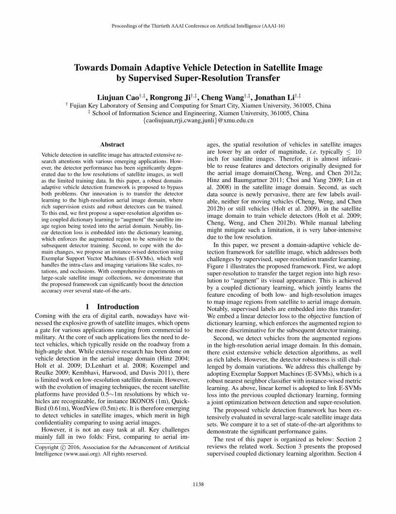
In this paper, we present a domain-adaptive vehicle de-tection framework for satellite image, which addresses bothchallenges by supervised, super-resolution transfer learning.Figure 1 illustrates the proposed framework. First, we adoptsuper-resolution to transfer the target region into high reso-lution to “augment” its visual appearance. This is achievedby a coupled dictionary learning, which jointly learns thefeature encoding of both low- and high-resolution imagesto map image regions from satellite to aerial image domain.Notably, supervised labels are embedded into this transfer:We embed a linear detector loss to the objective function ofdictionary learning, which enforces the augmented region tobe more discriminative for the subsequent detector training.
Second, we detect vehicles from the augmented regionsin the high-resolution aerial image domain. In this domain,there exist extensive vehicle detection algorithms, as wellas rich labels. However, the detector robustness is still chal-lenged by domain variations. We address this challenge byadopting Exemplar Support Machines (E-SVMs), which is arobust nearest neighbor classifier with instance-wised metriclearning. As above, linear kernel is adopted to link E-SVMsloss into the previous coupled dictionary learning, forminga joint optimization between detection and super-resolution.
The proposed vehicle detection framework has been ex-tensively evaluated in several large-scale satellite image datasets. We compare it to a set of state-of-the-art algorithms todemonstrate the significant performance gains.
The rest of this paper is organized as below: Section 2reviews the related work. Section 3 presents the proposedsupervised coupled dictionary learning algorithm. Section 4
Proceedings of the Thirtieth AAAI Conference on Artificial Intelligence (AAAI-16)
1138
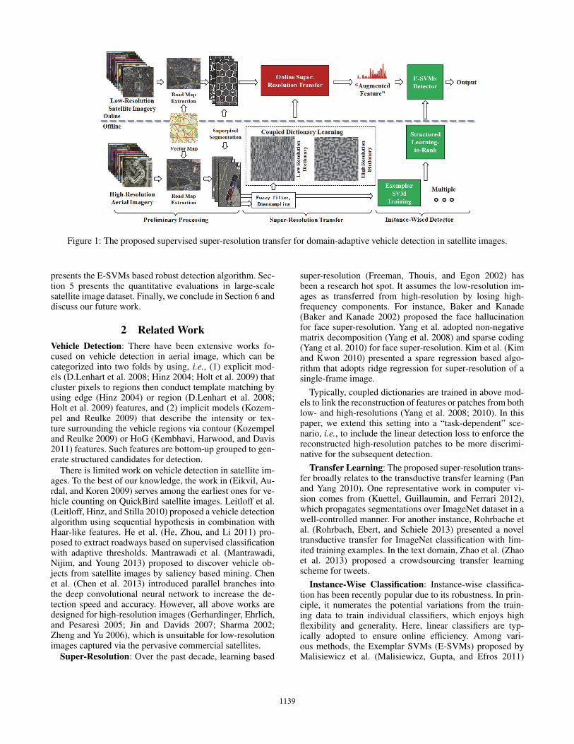
Figure 1: The proposed supervised super-resolution transfer for domain-adaptive vehicle detection in satellite images.
presents the E-SVMs based robust detection algorithm. Sec-tion 5 presents the quantitative evaluations in large-scalesatellite image dataset. Finally, we conclude in Section 6 anddiscuss our future work.
2 Related Work
Vehicle Detection: There have been extensive works fo-cused on vehicle detection in aerial image, which can becategorized into two folds by using, i.e., (1) explicit mod-els (D.Lenhart et al. 2008; Hinz 2004; Holt et al. 2009) thatcluster pixels to regions then conduct template matching byusing edge (Hinz 2004) or region (D.Lenhart et al. 2008;Holt et al. 2009) features, and (2) implicit models (Kozem-pel and Reulke 2009) that describe the intensity or tex-ture surrounding the vehicle regions via contour (Kozempeland Reulke 2009) or HoG (Kembhavi, Harwood, and Davis2011) features. Such features are bottom-up grouped to gen-erate structured candidates for detection.
There is limited work on vehicle detection in satellite im-ages. To the best of our knowledge, the work in (Eikvil, Au-rdal, and Koren 2009) serves among the earliest ones for ve-hicle counting on QuickBird satellite images. Leitloff et al.(Leitloff, Hinz, and Stilla 2010) proposed a vehicle detectionalgorithm using sequential hypothesis in combination withHaar-like features. He et al. (He, Zhou, and Li 2011) pro-posed to extract roadways based on supervised classificationwith adaptive thresholds. Mantrawadi et al. (Mantrawadi,Nijim, and Young 2013) proposed to discover vehicle ob-jects from satellite images by saliency based mining. Chenet al. (Chen et al. 2013) introduced parallel branches intothe deep convolutional neural network to increase the de-tection speed and accuracy. However, all above works aredesigned for high-resolution images (Gerhardinger, Ehrlich,and Pesaresi 2005; Jin and Davids 2007; Sharma 2002;Zheng and Yu 2006), which is unsuitable for low-resolutionimages captured via the pervasive commercial satellites.
Super-Resolution: Over the past decade, learning based
super-resolution (Freeman, Thouis, and Egon 2002) hasbeen a research hot spot. It assumes the low-resolution im-ages as transferred from high-resolution by losing high-frequency components. For instance, Baker and Kanade(Baker and Kanade 2002) proposed the face hallucinationfor face super-resolution. Yang et al. adopted non-negativematrix decomposition (Yang et al. 2008) and sparse coding(Yang et al. 2010) for face super-resolution. Kim et al. (Kimand Kwon 2010) presented a spare regression based algo-rithm that adopts ridge regression for super-resolution of asingle-frame image.
Typically, coupled dictionaries are trained in above mod-els to link the reconstruction of features or patches from bothlow- and high-resolutions (Yang et al. 2008; 2010). In thispaper, we extend this setting into a “task-dependent” sce-nario, i.e., to include the linear detection loss to enforce thereconstructed high-resolution patches to be more discrimi-native for the subsequent detection.
Transfer Learning: The proposed super-resolution trans-fer broadly relates to the transductive transfer learning (Panand Yang 2010). One representative work in computer vi-sion comes from (Kuettel, Guillaumin, and Ferrari 2012),which propagates segmentations over ImageNet dataset in awell-controlled manner. For another instance, Rohrbache etal. (Rohrbach, Ebert, and Schiele 2013) presented a noveltransductive transfer for ImageNet classification with lim-ited training examples. In the text domain, Zhao et al. (Zhaoet al. 2013) proposed a crowdsourcing transfer learningscheme for tweets.
Instance-Wise Classification: Instance-wise classifica-tion has been recently popular due to its robustness. In prin-ciple, it numerates the potential variations from the train-ing data to train individual classifiers, which enjoys highflexibility and generality. Here, linear classifiers are typ-ically adopted to ensure online efficiency. Among vari-ous methods, the Exemplar SVMs (E-SVMs) proposed byMalisiewicz et al. (Malisiewicz, Gupta, and Efros 2011)
1139
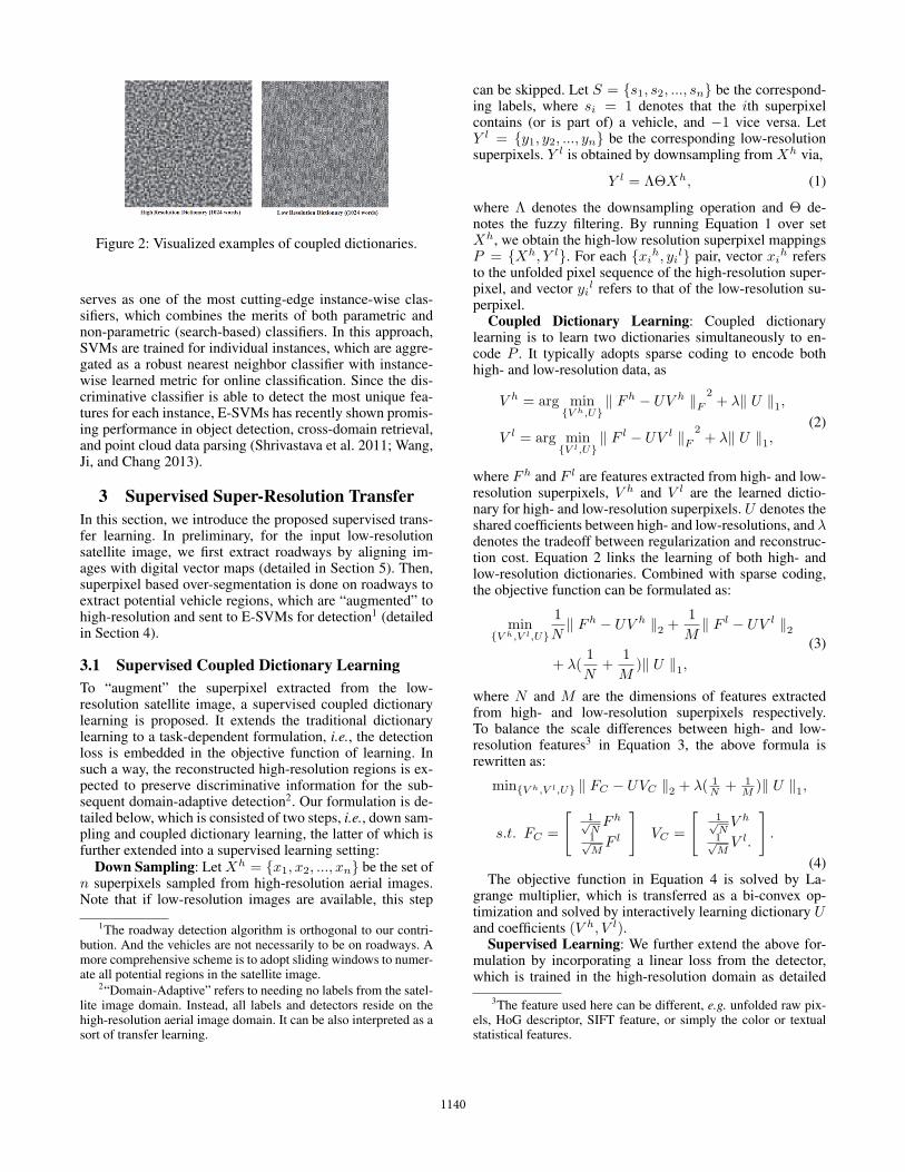
Figure 2: Visualized examples of coupled dictionaries.
serves as one of the most cutting-edge instance-wise clas-sifiers, which combines the merits of both parametric andnon-parametric (search-based) classifiers. In this approach,SVMs are trained for individual instances, which are aggre-gated as a robust nearest neighbor classifier with instance-wise learned metric for online classification. Since the dis-criminative classifier is able to detect the most unique fea-tures for each instance, E-SVMs has recently shown promis-ing performance in object detection, cross-domain retrieval,and point cloud data parsing (Shrivastava et al. 2011; Wang,Ji, and Chang 2013).
3 Supervised Super-Resolution Transfer
In this section, we introduce the proposed supervised trans-fer learning. In preliminary, for the input low-resolutionsatellite image, we first extract roadways by aligning im-ages with digital vector maps (detailed in Section 5). Then,superpixel based over-segmentation is done on roadways toextract potential vehicle regions, which are “augmented” tohigh-resolution and sent to E-SVMs for detection1 (detailedin Section 4).
3.1 Supervised Coupled Dictionary Learning
To “augment” the superpixel extracted from the low-resolution satellite image, a supervised coupled dictionarylearning is proposed. It extends the traditional dictionarylearning to a task-dependent formulation, i.e., the detectionloss is embedded in the objective function of learning. Insuch a way, the reconstructed high-resolution regions is ex-pected to preserve discriminative information for the sub-sequent domain-adaptive detection2. Our formulation is de-tailed below, which is consisted of two steps, i.e., down sam-pling and coupled dictionary learning, the latter of which isfurther extended into a supervised learning setting:
Down Sampling: Let Xh = {x1, x2, ..., xn} be the set ofn superpixels sampled from high-resolution aerial images.Note that if low-resolution images are available, this step
1The roadway detection algorithm is orthogonal to our contri-bution. And the vehicles are not necessarily to be on roadways. Amore comprehensive scheme is to adopt sliding windows to numer-ate all potential regions in the satellite image.
2“Domain-Adaptive” refers to needing no labels from the satel-lite image domain. Instead, all labels and detectors reside on thehigh-resolution aerial image domain. It can be also interpreted as asort of transfer learning.
can be skipped. Let S = {s1, s2, ..., sn} be the correspond-ing labels, where si = 1 denotes that the ith superpixelcontains (or is part of) a vehicle, and −1 vice versa. LetY l = {y1, y2, ..., yn} be the corresponding low-resolutionsuperpixels. Y l is obtained by downsampling from Xh via,
Y l = ΛΘXh, (1)
where Λ denotes the downsampling operation and Θ de-notes the fuzzy filtering. By running Equation 1 over setXh, we obtain the high-low resolution superpixel mappingsP = {Xh, Y l}. For each {xi
h, yil} pair, vector xi
h refersto the unfolded pixel sequence of the high-resolution super-pixel, and vector yil refers to that of the low-resolution su-perpixel.
Coupled Dictionary Learning: Coupled dictionarylearning is to learn two dictionaries simultaneously to en-code P . It typically adopts sparse coding to encode bothhigh- and low-resolution data, as
V h = arg min{V h,U}
‖ Fh − UV h ‖F2+ λ‖ U ‖1,
V l = arg min{V l,U}
‖ F l − UV l ‖F2+ λ‖ U ‖1,
(2)
where Fh and F l are features extracted from high- and low-resolution superpixels, V h and V l are the learned dictio-nary for high- and low-resolution superpixels. U denotes theshared coefficients between high- and low-resolutions, and λdenotes the tradeoff between regularization and reconstruc-tion cost. Equation 2 links the learning of both high- andlow-resolution dictionaries. Combined with sparse coding,the objective function can be formulated as:
min{V h,V l,U}
1
N‖ Fh − UV h ‖2 +
1
M‖ F l − UV l ‖2
+ λ(1
N+
1
M)‖ U ‖1,
(3)
where N and M are the dimensions of features extractedfrom high- and low-resolution superpixels respectively.To balance the scale differences between high- and low-resolution features3 in Equation 3, the above formula isrewritten as:
min{V h,V l,U} ‖ FC − UVC ‖2 + λ( 1N + 1
M )‖ U ‖1,
s.t. FC =
[1√NFh
1√MF l
]VC =
[1√NV h
1√MV l.
].
(4)The objective function in Equation 4 is solved by La-
grange multiplier, which is transferred as a bi-convex op-timization and solved by interactively learning dictionary Uand coefficients (V h, V l).
Supervised Learning: We further extend the above for-mulation by incorporating a linear loss from the detector,which is trained in the high-resolution domain as detailed
3The feature used here can be different, e.g. unfolded raw pix-els, HoG descriptor, SIFT feature, or simply the color or textualstatistical features.
1140
in Section 4. Instead of using Equation 4 for unsupervisedcase, we rewrite Equation 4 as:
min{V h,V l,U} ‖ FC − UVC ‖2 + λ( 1N + 1
M )‖ U ‖1,
+∑n
i=1 si(WTV h
siU + δ),
s.t. FC =
[1√NXh
1√MY l
]VC =
[1√NV h
1√MV l.
],
(5)where
∑ni=1 si(W
TV hsiU + δ) is the cost from n instance-
wised linear classifiers. The learned dictionary U enforcesthe reconstructed high-resolution feature to be discrimina-tive for the subsequent detection stage.
In online, given feature f l extracted from a candidate su-perpixel, sparse coding is conducted to transfer f l to fh =UV h, which is done by sharing reconstruction coefficientsu between high- and low-resolutions:
min ‖ U ‖0 s.t. ‖ V lU − f l ‖2 � ω. (6)
We further solve the above L0 norm optimization to the L1
norm, which revises the above formulation as:
min ‖ U ‖1 s.t. ‖ V lU − f l ‖2 � ω, (7)
by which the augmented feature fh in the high-resolutiondomain is obtained by fh = V hU .
Subsequently, detectors are run on this augmented featurefh to determine whether the candidate superpixel is vehicle.The detection scores from spatially nearby superpixels areaggregated with a non-maximal suppression. In the follow-ing section, we introduce the details of our instance-wisedvehicle detector.
4 Exemplar-SVMs for Vehicle Detector
The design of vehicle detector in the high-resolution do-main should pay special focus on the “cross-domain” varia-tions. In other words, the detector should be robust enoughagainst changes in spatial resolutions, visual appearance,imaging conditions, and camera viewing angles. We adoptan E-SVMs (Malisiewicz, Gupta, and Efros 2011) based,instance-wised detector scheme. In our observation, the ve-hicle appearances are highly changed due to the complicatedintra-class and imaging variations. Therefore, it is a morepractical solution to train instance-wised classifiers withinstance-specific metrics to conduct a refined nearest neigh-bor classification (Malisiewicz, Gupta, and Efros 2011). Thedetailed formulations of our vehicle detector are given as be-low:
Training: Given m labeled high-resolution superpixels{Si}mi=1, each of which is described by HoG feature and de-noted as fi. We train its Exemplar SVM with parameters(wi, bi) using a randomly sampled negative set Ni from su-perpixels without vehicles. We optimize the following con-vex objective function:
ΩE(wi, bi) = ‖ w ‖2 + C1h(wTi fi + bi) +
C2
∑j∈Ni
h(−wTj − bj),
(8)
Algorithm 1: Domain-Adaptive Vehicle Detection inSatellite Images by Super Resolution Transfer
Offline:Input: n superpixels: Xh = {x1, x2, ..., xn} withlabels: S = {s1, s2, ..., sn}Downsampling: Do Y l = ΛΘXh to generate low-res.superpixels: Y l = {y1, y2, ..., yn}Super-Resolution Transfer:
Learn Coupled Dictionary by Equation 4Do Pre-Detection by
∑ni=1 si(W
TFhsi + δ)
Learn Supervised Dictionary by Equation 5Instance-Wised Detector Training:
Train each E-SVM by Equation 8Calibrate E-SVMs by Hinge Loss learned via
structured learning-to-rank using Equation 10Output: Low- and high-res. dic.s V l, V h, and thelearnedE-SVMs {we, be}ne=1.Online:Given target low-res. superpixel y, do super-resolutionto obtain high-res. coeff. u, send to E-SVMs detectionin Equation 12.
where h(x) is the Hinge loss, i.e., Max(0, 1-x). To furtherguarantee the matching robustness, every superpixel Si isflipped, translated and rotated to expand to more positiveexamples for training.
Calibration: After learning all of the E-SVMs with pa-rameters {wi, bi}ni=1, we further calibrate their outputs. Thisis achieved by learning a sigmoid function (αE ,βE) usingthe validation set, with the calibration test score is:
f(x|wE , αE , βE) =1
1+e−αE(wET x−βE)
. (9)
By thresholding the original SVM score -1 (negative bor-der), the learned parameters of the Sigmoid function can beused to adjust parameters of each detector.
To calibrate, given a held-out validation set with groundtruth labels SH = {Sq}Hq=1, we first apply the E-SVMs toget prediction scores {sq}Hq=1, and then collect SVMs withpositive scores for re-ranking (only some of them are withthe same label as Sq). For each E-SVM in S, we force su-perpixels with the same label of Sq to have larger score thanothers. This can be formulated as a structured learning-to-rank (Joachims 2002):
min∑i
1
2||w||22 + C
∑ξi,j,k
s.t. ∀qi, wTΦ(qi, sj) > wTΦ(qi, sk) + 1− ξi,j,k
∀l(Sj) = l(Sqi), l(Sk) �= l(Sqi), ξi,j,k ≥ 0.
(10)
Here w ={(wi, bi)
}n
i=1. Φ(qi, sj)’s (2j − 1)th and 2jth
dimensions are sj and 1 respectively, which encodes weightsand scores into a single vector. It can be learned by solvinga cutting plane optimization (Tsochantaridis et al. 2005).
Hard Negative Mining: Different from regular E-SVMsthat only finds nearly identical instances, we set a small C2
in the training process to improve the generality, which al-lows similar but not exact examples to have positive scores.
1141
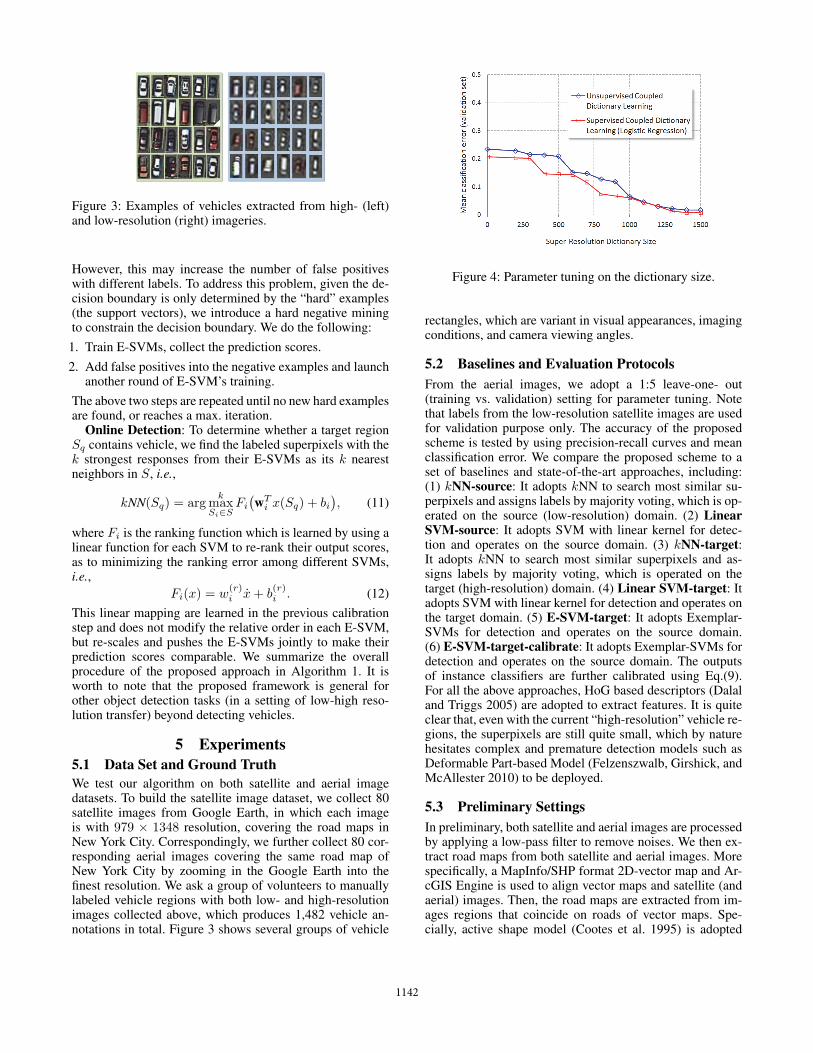
Figure 3: Examples of vehicles extracted from high- (left)and low-resolution (right) imageries.
However, this may increase the number of false positiveswith different labels. To address this problem, given the de-cision boundary is only determined by the “hard” examples(the support vectors), we introduce a hard negative miningto constrain the decision boundary. We do the following:
1. Train E-SVMs, collect the prediction scores.2. Add false positives into the negative examples and launch
another round of E-SVM’s training.The above two steps are repeated until no new hard examplesare found, or reaches a max. iteration.
Online Detection: To determine whether a target regionSq contains vehicle, we find the labeled superpixels with thek strongest responses from their E-SVMs as its k nearestneighbors in S, i.e.,
kNN(Sq) = argk
maxSi∈S
Fi
(wT
i x(Sq) + bi), (11)
where Fi is the ranking function which is learned by using alinear function for each SVM to re-rank their output scores,as to minimizing the ranking error among different SVMs,i.e.,
Fi(x) = w(r)i x+ b
(r)i . (12)
This linear mapping are learned in the previous calibrationstep and does not modify the relative order in each E-SVM,but re-scales and pushes the E-SVMs jointly to make theirprediction scores comparable. We summarize the overallprocedure of the proposed approach in Algorithm 1. It isworth to note that the proposed framework is general forother object detection tasks (in a setting of low-high reso-lution transfer) beyond detecting vehicles.
5 Experiments
5.1 Data Set and Ground Truth
We test our algorithm on both satellite and aerial imagedatasets. To build the satellite image dataset, we collect 80satellite images from Google Earth, in which each imageis with 979 × 1348 resolution, covering the road maps inNew York City. Correspondingly, we further collect 80 cor-responding aerial images covering the same road map ofNew York City by zooming in the Google Earth into thefinest resolution. We ask a group of volunteers to manuallylabeled vehicle regions with both low- and high-resolutionimages collected above, which produces 1,482 vehicle an-notations in total. Figure 3 shows several groups of vehicle
Figure 4: Parameter tuning on the dictionary size.
rectangles, which are variant in visual appearances, imagingconditions, and camera viewing angles.
5.2 Baselines and Evaluation Protocols
From the aerial images, we adopt a 1:5 leave-one- out(training vs. validation) setting for parameter tuning. Notethat labels from the low-resolution satellite images are usedfor validation purpose only. The accuracy of the proposedscheme is tested by using precision-recall curves and meanclassification error. We compare the proposed scheme to aset of baselines and state-of-the-art approaches, including:(1) kNN-source: It adopts kNN to search most similar su-perpixels and assigns labels by majority voting, which is op-erated on the source (low-resolution) domain. (2) LinearSVM-source: It adopts SVM with linear kernel for detec-tion and operates on the source domain. (3) kNN-target:It adopts kNN to search most similar superpixels and as-signs labels by majority voting, which is operated on thetarget (high-resolution) domain. (4) Linear SVM-target: Itadopts SVM with linear kernel for detection and operates onthe target domain. (5) E-SVM-target: It adopts Exemplar-SVMs for detection and operates on the source domain.(6) E-SVM-target-calibrate: It adopts Exemplar-SVMs fordetection and operates on the source domain. The outputsof instance classifiers are further calibrated using Eq.(9).For all the above approaches, HoG based descriptors (Dalaland Triggs 2005) are adopted to extract features. It is quiteclear that, even with the current “high-resolution” vehicle re-gions, the superpixels are still quite small, which by naturehesitates complex and premature detection models such asDeformable Part-based Model (Felzenszwalb, Girshick, andMcAllester 2010) to be deployed.
5.3 Preliminary Settings
In preliminary, both satellite and aerial images are processedby applying a low-pass filter to remove noises. We then ex-tract road maps from both satellite and aerial images. Morespecifically, a MapInfo/SHP format 2D-vector map and Ar-cGIS Engine is used to align vector maps and satellite (andaerial) images. Then, the road maps are extracted from im-ages regions that coincide on roads of vector maps. Spe-cially, active shape model (Cootes et al. 1995) is adopted
1142
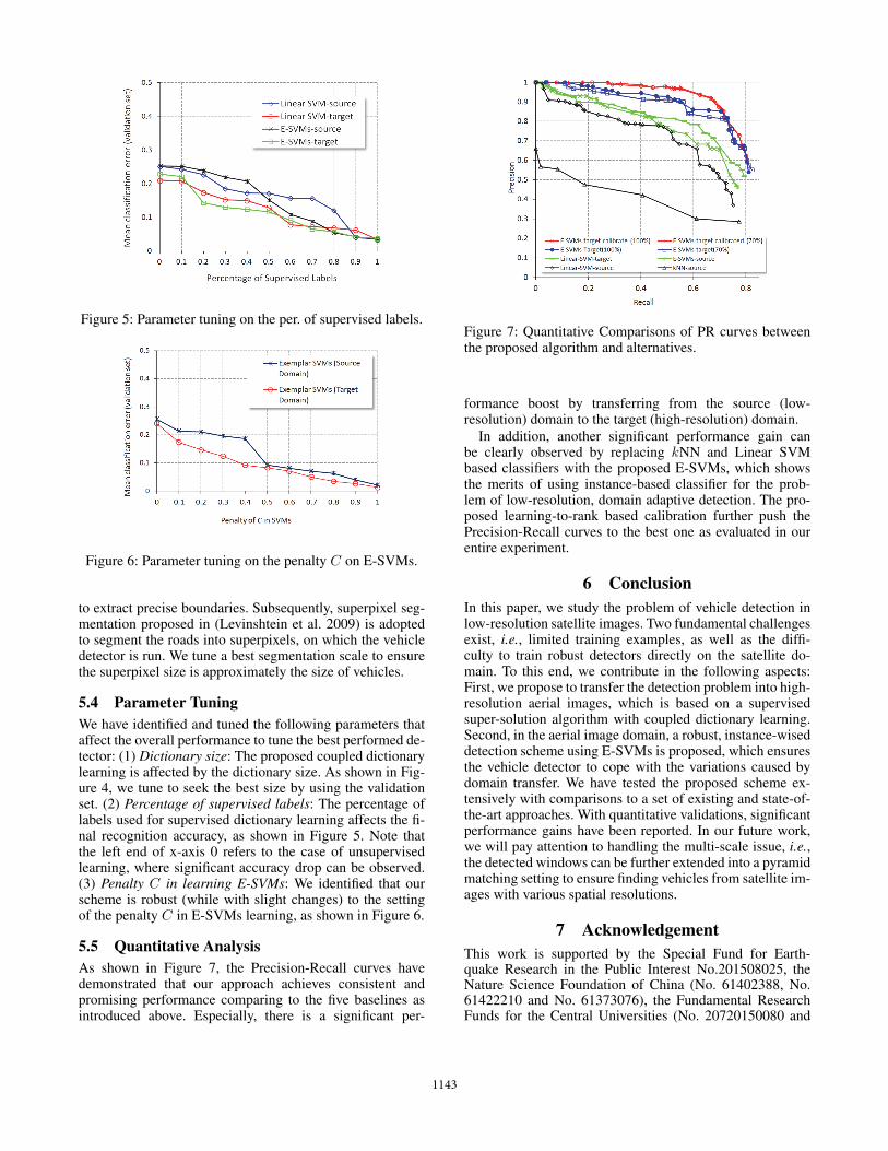
Figure 5: Parameter tuning on the per. of supervised labels.
Figure 6: Parameter tuning on the penalty C on E-SVMs.
to extract precise boundaries. Subsequently, superpixel seg-mentation proposed in (Levinshtein et al. 2009) is adoptedto segment the roads into superpixels, on which the vehicledetector is run. We tune a best segmentation scale to ensurethe superpixel size is approximately the size of vehicles.
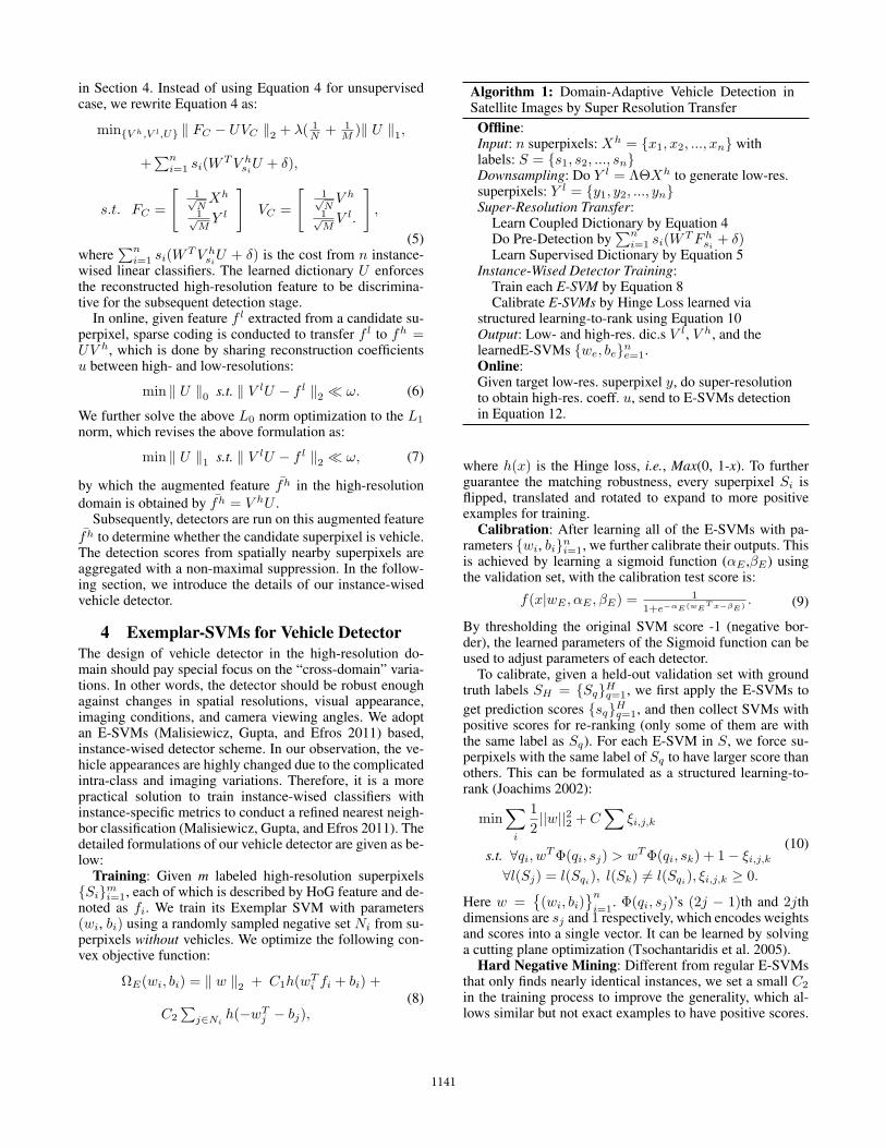
5.4 Parameter Tuning
We have identified and tuned the following parameters thataffect the overall performance to tune the best performed de-tector: (1) Dictionary size: The proposed coupled dictionarylearning is affected by the dictionary size. As shown in Fig-ure 4, we tune to seek the best size by using the validationset. (2) Percentage of supervised labels: The percentage oflabels used for supervised dictionary learning affects the fi-nal recognition accuracy, as shown in Figure 5. Note thatthe left end of x-axis 0 refers to the case of unsupervisedlearning, where significant accuracy drop can be observed.(3) Penalty C in learning E-SVMs: We identified that ourscheme is robust (while with slight changes) to the settingof the penalty C in E-SVMs learning, as shown in Figure 6.
5.5 Quantitative Analysis
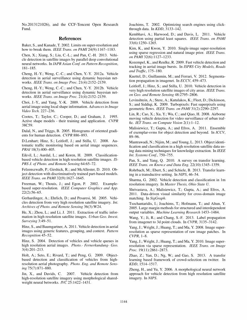
As shown in Figure 7, the Precision-Recall curves havedemonstrated that our approach achieves consistent andpromising performance comparing to the five baselines asintroduced above. Especially, there is a significant per-
Figure 7: Quantitative Comparisons of PR curves betweenthe proposed algorithm and alternatives.
formance boost by transferring from the source (low-resolution) domain to the target (high-resolution) domain.
In addition, another significant performance gain canbe clearly observed by replacing kNN and Linear SVMbased classifiers with the proposed E-SVMs, which showsthe merits of using instance-based classifier for the prob-lem of low-resolution, domain adaptive detection. The pro-posed learning-to-rank based calibration further push thePrecision-Recall curves to the best one as evaluated in ourentire experiment.
6 Conclusion
In this paper, we study the problem of vehicle detection inlow-resolution satellite images. Two fundamental challengesexist, i.e., limited training examples, as well as the diffi-culty to train robust detectors directly on the satellite do-main. To this end, we contribute in the following aspects:First, we propose to transfer the detection problem into high-resolution aerial images, which is based on a supervisedsuper-solution algorithm with coupled dictionary learning.Second, in the aerial image domain, a robust, instance-wiseddetection scheme using E-SVMs is proposed, which ensuresthe vehicle detector to cope with the variations caused bydomain transfer. We have tested the proposed scheme ex-tensively with comparisons to a set of existing and state-of-the-art approaches. With quantitative validations, significantperformance gains have been reported. In our future work,we will pay attention to handling the multi-scale issue, i.e.,the detected windows can be further extended into a pyramidmatching setting to ensure finding vehicles from satellite im-ages with various spatial resolutions.
7 Acknowledgement
This work is supported by the Special Fund for Earth-quake Research in the Public Interest No.201508025, theNature Science Foundation of China (No. 61402388, No.61422210 and No. 61373076), the Fundamental ResearchFunds for the Central Universities (No. 20720150080 and
1143
No.2013121026), and the CCF-Tencent Open ResearchFund.
References
Baker, S., and Kanade, T. 2002. Limits on super-resolution andhow to break them. IEEE Trans. on PAMI 24(9):1167–1183.Chen, X.; Xiang, S.; Liu, C.-L.; and Pan, C.-H. 2013. Vehi-cle detection in satellite images by parallel deep convolutionalneural networks. In IAPR Asian Conf. on Pattern Recognition,181–185.Cheng, H.-Y.; Weng, C.-C.; and Chen, Y.-Y. 2012a. Vehicledetection in aerial surveillance using dynamic bayesian net-works. IEEE Trans. on Image Proc. 21(4):2152–2159.Cheng, H.-Y.; Weng, C.-C.; and Chen, Y.-Y. 2012b. Vehicledetection in aerial surveillance using dynamic bayesian net-works. IEEE Trans. on Image Proc. 21(4):2152–2159.Choi, J.-Y., and Yang, Y.-K. 2009. Vehicle detection fromaerial image using local shape information. Advances in ImageVideo Tech. 227–236.Cootes, T.; Taylor, C.; Cooper, D.; and Graham, J. 1995.Active shape models - their training and application. CVPR38C59.Dalal, N., and Triggs, B. 2005. Histograms of oriented gradi-ents for human detection. CVPR 886–893.D.Lenhart; Hinz, S.; Leitloff, J.; and Stilla, U. 2008. Au-tomatic traffic monitoring based on aerial image sequences.PRAI 18(3):400–405.Eikvil, L.; Aurdal, L.; and Koren, H. 2009. Classification-based vehicle detection in high resolution satellite images. IS-PRS J. of Photo. and Remote Sensing 64:65–72.Felzenszwalb, P.; Girshick, R.; and McAllester, D. 2010. Ob-ject detection with discriminatively trained part-based models.IEEE Trans. on PAMI 32(9):1627–1645.Freeman, W.; Thouis, J.; and Egon, P. 2002. Example-based super-resolution. IEEE Computer Graphics and App.22(2):56–65.Gerhardinger, A.; Ehrlich, D.; and Pesaresi, M. 2005. Vehi-cles detection from very high resolution satellite imagery. Int.Archives of Photo. and Remote Sensing 36(3):W24.He, X.; Zhou, L.; and Li, J. 2011. Extraction of traffic infor-mation in high resolution satellite images. Urban Geo. Invest.Surveying 3:49–51.Hinz, S., and Baumgartner, A. 2011. Vehicle detection in aerialimages using generic features, grouping, and context. PatternRecognition 45–52.Hinz, S. 2004. Detection of vehicles and vehicle queues inhigh resolution aerial images. Photo.- Fernerkundung- Geo.3(4):201–213.Holt, A.; Seto, E.; Rivard, T.; and Peng, G. 2009. Object-based detection and classification of vehicles from high-resolution aerial photography. Photo. Eng. and Remote Sens-ing 75(7):871–880.Jin, X., and Davids, C. 2007. Vehicle detection fromhigh-resolution satellite imagery using morphological shared-weight neural betworks. IVC 25:1422–1431.
Joachims, T. 2002. Optimizing search engines using click-through data. In KDD, 3133–142.Kembhavi, A.; Harwood, D.; and Davis, L. 2011. Vehicledetection using partial least squares. IEEE Trans. on PAMI33(6):1250–1265.Kim, K., and Kwon, Y. 2010. Single-image super-resolutionusing sparse regression and natural image prior. IEEE Trans.on PAMI 32(6):1127–1233.Kozempel, K., and Reulke, R. 2009. Fast vehicle detection andtracking in aerial image bursts. In ISPRS City Models, Roadsand Traffic, 175–180.Kuettel, D.; Guillaumin, M.; and Ferrari, V. 2012. Segmenta-tion propagation in imagenet. In ECCV, 459–473.Leitloff, J.; Hinz, S.; and Stilla, U. 2010. Vehicle detection invery high resolution satellite images of city areas. IEEE Trans.on Geo. and Remote Sensing 48:2795–2806.Levinshtein, A.; Stere, A.; Kutulakos, K.; Fleet, D.; Dickinson,S.; and Siddiqi, K. 2009. Turbopixels: Fast superpixels usinggeometric flows. IEEE Trans. on PAMI 31(2):2290–2297.Lin, R.; Cao, X.; Xu, Y.; Wu, C.; and Qiao, H. 2008. Airbornemoving vehicle detection for video surveillance of urban traf-fic. IET Trans. on Compute Vision 2(1):1–12.Malisiewicz, T.; Gupta, A.; and Efros, A. 2011. Ensembleof exemplar-svms for object detection and beyond. In ICCV,89–96.Mantrawadi, N.; Nijim, M.; and Young, L. 2013. Object identi-fication and classification in a high resolution satellite data us-ing data mining techniques for knowledge extraction. In IEEEInt. Systems Conf., 750–755.Pan, S., and Yang, Q. 2010. A survey on transfer learning.IEEE Trans. on Know.e and Data Eng. 22(10):1345–1359.Rohrbach, M.; Ebert, S.; and Schiele, B. 2013. Transfer learn-ing in a transductive setting. In NIPS, 46–54.Sharma, G. 2002. Vehicle detection and classification in 1mresolution imagery. In Master Thesis, Ohio State U.Shrivastava, A.; Malisiewicz, T.; Gupta, A.; and Efros, A.2011. Data-driven visual similarity for cross-domain imagematching. In SigGraph.Tsochantaridis, I.; Joachims, T.; Hofmann, T.; and Altun, Y.2005. Large margin methods for structured and interdependentoutput variables. Machine Learning Research 1453–1484.Wang, Y.; Ji, R.; and Chang, S.-F. 2013. Label propagationfrom imagenet to 3d point clouds. In CVPR, 3135–3142.Yang, J.; Wright, J.; Huang, T.; and Ma, Y. 2008. Image super-resolution as sparse representation of raw image patches. InCVPR, 1–8.Yang, J.; Wright, J.; Huang, T.; and Ma, Y. 2010. Image super-resolution via sparse representation. IEEE Trans. on ImageProc. 19(11):2861–2873.Zhao, Z.; Yan, D.; Ng, W.; and Gao, S. 2013. A transferlearning based framework of crowd-selection on twitter. InKDD, 1514–1517.Zheng, H., and Yu, Y. 2006. A morphological neural networkapproach for vehicle detection from high resolution satelliteimagery. In NIPS.
1144