town of colonie comprehensive plan of colonie comprehensive plan ... as with inner suburbs across...
TRANSCRIPT
Landscape Architects, Architects, ©Copyright All Rights Reserved Saratoga Associates #04039 Engineers and Planners, P.C.
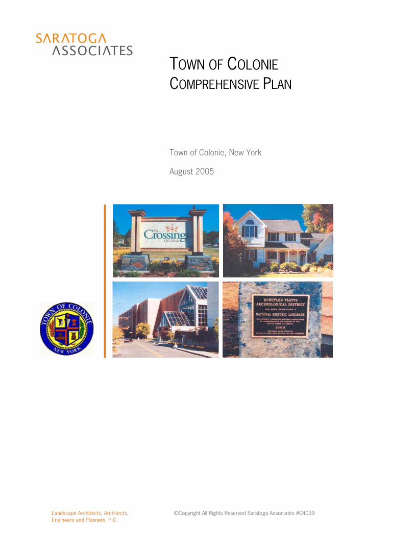
TOWN OF COLONIE COMPREHENSIVE PLAN
Town of Colonie, New York August 2005
Town of Colonie Comprehensive Plan
Adopted by the Town Board on August 25, 2005
ACKNOWLEDGEMENTS
Comprehensive Plan Advisory Committee Richard Sleasman, Chair
Christopher Einstein Bill Herman Brian Hogan Ellen Pemrick
Maggie Vinciguerra
Colonie Town Board Mary Brizzell, Supervisor
Ulderic Boisvert Kevin Bronner Brian Hogan
Nicole Criscione-Szesnat Frank Mauriello Thomas With
Town of Colonie Planning and Economic Development Department Philip Pearson, Director
Kelly Brown-Mateja Kevin Delaughter Michael Lyons
A special thank you to the New York State Hudson River Valley Greenway for grant funding assistance for the development of this comprehensive plan.
Town of Colonie Comprehensive Plan Executive Summary Table of Contents SECTION 1 – Introduction
1.1 Introduction .....................................................................................................................1 1.2 Public Involvement Process ..............................................................................................2
SECTION 2 – Vision and Goals 2.1 Vision ...........................................................................................................................5 2.2 Goals ...........................................................................................................................5
SECTION 3 – Plan Recommendations 3.1 Neighborhoods...............................................................................................................14 3.2 Neighborhood Commercial Centers..................................................................................17 3.3 Industrial Revitalization Areas...........................................................................................19 3.4 Primary Transportation Corridors .....................................................................................24 3.5 Mixed Use Nodes............................................................................................................33 3.6 Office Mixed Use Areas ...................................................................................................33 3.7 Commercial Retail Areas .................................................................................................34 3.8 Airport Business Area......................................................................................................35 3.9 Mohawk River Revitalization Area .....................................................................................36 3.10 Pine Bush Area ...............................................................................................................38 3.11 Colonie Gateways ...........................................................................................................40 3.12 Town-wide Recommendations ..........................................................................................41
Connections and Pathways..................................................................................41 Transportation ...................................................................................................42 Economic Development ......................................................................................44 Stormwater Management....................................................................................46 Infrastructure .....................................................................................................46 Historic and Cultural Resources...........................................................................49
SECTION 4 – Plan Recommendations Map
SECTION 5 – Town-wide Open Space and Recreation Plan 5.1 Overview........................................................................................................................52 5.2 Existing Open Space and Recreation Resources................................................................53 5.3 Opportunities for Open Space and Recreation ...................................................................57 5.4 Recommended Actions for Open Space and Recreation ....................................................60
SECTION 6 – Open Space and Recreation Plan Map
SECTION 7 – Implementation and Action Plan 7.1 Immediate Actions ..........................................................................................................68 7.2 Short-Term Actions .........................................................................................................70 7.3 Mid-Term Actions ............................................................................................................74 7.4 On-going Actions.............................................................................................................75 7.5 Long-Term Actions..........................................................................................................76
Appendices (under separate cover) Appendix A – Inventory and Analysis* Appendix B – Initial Neighborhood Meeting Results* Appendix C – Community Survey Results* Appendix D – Public Meeting Notes Appendix E – CPAC Public Hearing Minutes Appendix F – Table of Planning Resources and Documents **Appendix G – Town Board Public Hearing Documents including the following: Transcripts Related Correspondence Supporting Documentation
*Prepared by the Town of Colonie Planning & Economic Development Department **Town Board Public Hearing Documents are available in the Town of Colonie Town Clerk’s Office.

Executive Summary

Town of Colonie Comprehensive Plan August 2005
Executive Summary i
Executive Summary The Town of Colonie is one of Capital Region’s oldest suburban communities. As with inner suburbs across the nation, Colonie is beginning to see the impacts of regional growth beyond its borders. Some of its once vibrant commercial areas are showing signs of age, as are some of the older residential neighborhoods in Town. The Town’s industrial areas are in need of a breath of new life. However, while some areas are in need of attention and revitalization, the Town of Colonie continues to be successful in many important ways. It is recognized as a very safe community, it has good public and private schools, and it is located very conveniently in the region. The Town provides excellent basic services, and has an extensive parks system. Taxes remain low due to good fiscal management and a diverse tax base.
The Town has decided to take a comprehensive look at issues related to its continued growth and development. The Town’s primary concerns looking forward include ensuring the community remains a great place to live, work, and visit, attracting new industry and employment opportunities, and conserving the area’s natural resources and remaining open spaces. PROCESS The Town of Colonie began the comprehensive planning process in 2003. A full discussion of the comprehensive planning process can be found in Section 1.2. Several neighborhood meetings and a community survey were among the first public outreach activities to take place as part of the comprehensive planning process. A meeting was also held at the Beltrone Living Center to discuss issues related to seniors in the Town and another meeting was held with the business community to discuss their specific needs. Results from these meetings, as well as additional public workshops and focus groups, can be found in the appendix and on the Town website at www.colonie.org. In 2004, the Town hired Saratoga Associates to assist in completing the comprehensive plan, and the Town Board established the Comprehensive Plan Advisory Committee (CPAC). The CPAC included a cross-section of residents who have been involved in community activities as well as Town staff. The CPAC held over twenty-two committee meetings throughout the comprehensive planning process. All committee meetings were open to the public and a portion of the agenda at each meeting was devoted to public comment. In addition to the previously mentioned meetings and community survey, the CPAC reached out to the public on several other occasions including:
> Issues Identification and Visioning Workshop
> Focus Group Meetings > Business Workshop > Youth Workshop
> Townwide Meeting 1 > Townwide Meeting 2 > Comprehensive Plan Advisory
Committee (CPAC) Public Hearing > Town Board Public Hearing

Town of Colonie Comprehensive Plan August 2005
Executive Summary iii
VISION The Town of Colonie established a Vision Statement and set of goals to guide the development of the Comprehensive Plan. The Vision Statement is found below and the Town-wide Goals are found in Section 2.2. In the Year 2020… The Town of Colonie is among the oldest, largest, and most well-established suburban communities in the Capital Region. Conveniently located at the heart of the region, it is home to a broad spectrum of residents, businesses, and institutions. It has succeeded in stabilizing and enhancing existing neighborhoods, regenerating and reinventing its historic commercial corridors and industrial areas, conserving a network of significant open spaces, and maintaining its exceptional quality of life. As a result, Colonie is among the most affordable and desirable places to live, learn, and do business in the region. RECOMMENDATIONS Section 3 of the Comprehensive Plan identifies dozens of recommendations for neighborhoods, neighborhood commercial centers, industrial revitalization areas, primary transportation corridors, mixed use nodes, office mixed use areas, commercial retail areas, airport business area, the Mohawk River area, the Pine Bush area, gateways, connections and pathways, transportation, economic development, stormwater management, infrastructure, and historic and cultural resources. Section 5 includes the Town-wide Open Space and Recreation Plan and identifies recommendations targeted specifically toward open space and recreation. In developing plan recommendations, several major concepts created a framework for thinking about the immediate and long-term future of the Town. Those concepts include the following:
> Recognize what is working well > Identify areas where improvements are needed > Focus development in mixed use centers or nodes > Emphasize quality of life > Become pro-active about economic development > Conserve natural and open space resources > Create connections
IMPLEMENTATION Section 7 outlines a strategy for implementing the plan’s major recommendations. Within this section, specific actions necessary to implement the plan are described and prioritized. It is recognized that some actions should be implemented immediately, while others can be accomplished over several years. Although preference may be to implement all of the recommendations
Town of Colonie Comprehensive Plan August 2005
Executive Summary iii
immediately, an incremental approach is likely to be more efficient and realistic based on the availability of staff, funding resources, and volunteers. Immediate Actions (within 1 year)
> Update zoning and subdivision regulations > Establish a regular system for monitoring implementation of the comprehensive plan > Consider acceptance of the Mohawk River Waterfront Revitalization Study and the Route 7
– Route 2 Corridor Land Use/Transportation Linkage Study
Short-Term Actions (within 1-2 years) > Restructure the Planning and Economic Development Department > Enhance gateways to the Town > Develop a Town-wide Economic Development Strategy > Pursue redevelopment initiative for the Lincoln Avenue Industrial Revitalization Area > Consider reducing street widths in new residential development > Institute a snow emergency regulations > Develop a Town-wide sidewalk plan > Establish an official map > Identify priority areas for open space conservation and develop a funding mechanism > Develop a Parks and Recreation Master Plan > Develop a neighborhood planning initiative utilizing West Albany for the first neighborhood
plan > Establish an innovation homeownership program within the Town target older
neighborhoods
Mid-Term Actions (within 2-5 years) > Implement traffic calming measures > Establish a system of bicycle routes and provide appropriate signage > Compile and organize existing historic and cultural resource information to develop a
comprehensive Town-wide inventory > Update existing Generic Environment Impact Statements
On-going Actions
> Encourage education for Town planning staff, Town Board members, the Planning Board and the Zoning Board
> Prepare for and comply with the new Phase II Stormwater Management Regulations
Long-Term Actions (within 5-10 years) > Update the Comprehensive Plan

Section 1 - Introduction

Town of Colonie Comprehensive Plan August 2005 Introduction Page 1
Section 1 1.1 INTRODUCTION The Town of Colonie is one of Capital Region’s oldest suburban communities. As with inner suburbs across the nation, Colonie is beginning to see the impacts of regional growth beyond its borders. Some of its once vibrant commercial areas are showing signs of age, as are some of the older residential neighborhoods in Town. The Town’s industrial areas are in need of a breath of new life. However, while some areas are in need of attention and revitalization, the Town of Colonie continues to be successful in many important ways. It is recognized as a very safe community, it has good public and private schools, and it is located very conveniently in the region. The Town provides excellent basic services, and has an extensive parks system. Taxes remain low due to good fiscal management and a diverse tax base. Looking toward the future, the Town of Colonie seeks to recognize its assets and maintain what is working well, while identifying and addressing improvements that are needed. The Town has continued to grow in population, and with its current population of approximately 80,000 persons it is the region’s second largest municipality. Population projections from the Capital District Regional Planning Commission suggest that the Town’s population could surpass 85,000 by 2040. Though much of the Town appears “built-out”, a build out analysis conducted by the Town’s Planning and Economic Development Department (PEDD) as part of this study indicates that there is still significant potential for continued residential and commercial development on undeveloped land throughout the community. Results of the analysis are summarized in the graphic at right. It is important to recognize that this analysis does not contemplate the redevelopment of existing sites. Furthermore, a build out analysis does not consider actual development trends in the community (i.e. building permits issued) or market conditions. It merely presents a theoretical calculation of what would be possible under current zoning. It does, however, demonstrate that the Town of Colonie is not “built out.” The Town has decided to take a comprehensive look at issues related to its continued growth and development. The Town’s primary concerns looking forward include ensuring the community remains a great place to live, work, and visit, attracting new industry and employment opportunities, and conserving the area’s natural resources and remaining open spaces.

Town of Colonie Comprehensive Plan August 2005 Introduction Page 2
This Comprehensive Plan for the Town of Colonie: > Identifies needs, assets and opportunities; > Is founded on a community-based process which includes input from residents, businesses,
institutions, environmental interests and others; > Results in a coordinated vision for the future of Colonie; > Outlines actions to achieve the shared vision; and > Establishes a framework for community-wide efforts on plan implementation.
It is important to note that the Comprehensive Plan is a dynamic document focusing on a wide-range of issues affecting the community. The Plan does not, however, examine project-specific issues. Rather, the Plan examines a broader set of Town-wide issues, provides recommendations to address such issues and outlines an implementation strategy to achieve success. 1.2 PUBLIC INVOLVEMENT PROCESS The Town of Colonie began the comprehensive planning process in 2003. Several neighborhood meetings and a community survey were among the first public outreach activities to take place as part of the comprehensive planning process. For the purposes of the neighborhood meetings, the Town was divided into five planning areas: Westside, Colonie North, Latham, Colonie South, and Loudonville. Neighborhood meetings were held in each of these planning areas. A meeting was also held at the Beltrone Living Center to discuss issues related to seniors in the Town and another meeting was held with the business community to discuss their specific needs. Results from these meetings, as well as additional public workshops and focus groups, can be found in the appendix and on the Town website at www.colonie.org. The community survey was mailed to all households in the Town of Colonie – approximately 35,000 households. The survey response rate was 15%, which means that approximately 4,900 citizen responses were considered in the development of the Comprehensive Plan. Forty-three questions were asked that addressed a variety issues such as growth, housing, traffic congestion, bicycle and pedestrian facilities, recreation facilities, environmental concerns, open space preservation, business, employment, Town services, and the type of residential development that should be encouraged. The top three positive aspects of Colonie identified by survey respondents included a convenient location, schools and reasonable taxes. The top three concerns regarding the Town according to the survey included traffic, overdevelopment and a lack of sidewalks. Given these concerns, however, nearly 85% of respondents indicated they expect to be living in the Town of Colonie five years from now. This response indicates the long-term commitment many residents are making to the Town and reflects the quality of services provided by and within the community. Full survey results are found on the website at www.colonie.org and also in the appendix. In 2004, the Town hired Saratoga Associates to assist in completing the comprehensive plan, and the Town Board established the Comprehensive Plan Advisory Committee (CPAC). The CPAC included a cross-section of residents who have been involved in community activities as well as Town staff. The CPAC held over twenty committee meetings throughout the comprehensive planning process. All

Town of Colonie Comprehensive Plan August 2005 Introduction Page 3
committee meetings were open to the public and a portion of the agenda at each meeting was devoted to public comment. In addition to the previously mentioned meetings and community survey, the CPAC reached out to the public on several other occasions including:
> Issues Identification and Visioning Workshop – The purpose of this public workshop was to introduce the community to the comprehensive planning process. In addition, participants were asked to work together to define the Town’s strengths and identify issues that should be addressed in the plan. As the second part of this workshop, participants were asked to take part in an image preference evaluation. Over 50 images were shown illustrating various styles and types of commercial development, housing, streetscape and public spaces. Participants were given a scorecard and asked to rate each image on a scale of 1 to 7. A score of 1 indicated that the image was undesirable or inappropriate; a score of 4 was considered indifferent, while a score of 7 indicated that the image was very desirable or appropriate for Colonie.
> Focus Group Meetings – There were six (6) focus group meetings discussing topics that
included open space, recreation, transportation, economic development, housing, and development patterns.
> Business Workshop – A business workshop was held to discuss the future of the Town from
the perspective of business owners.
> Youth Workshop – As part of a regularly scheduled Youth Advisory Group meeting, the needs and opportunities for the community’s youth were discussed.
> Townwide Meeting 1 – The purpose of this townwide meeting on February 9, 2005 was to
introduce the plan vision statement and goals, and to present and discuss preliminary plan concepts. Attendees were asked to provide feedback about the direction of the preliminary plan concepts.
> Townwide Meeting 2 – The purpose of this second townwide meeting will be to solicit
public input about the draft plan. The draft plan document will be available for public review in advance of this meeting. Feedback from this meeting will be considered in the development of the committee’s final draft plan.
> Comprehensive Plan Advisory Committee (CPAC) Public Hearing - The purpose of this
public hearing was to receive comments about the committee’s final draft plan. As required by state law, the CPAC conducted this formal public hearing before voting on a resolution to forward the final draft plan to the Town Board for its consideration.

Town of Colonie Comprehensive Plan August 2005 Introduction Page 4
> Town Board Public Hearing – Once it formally received the Final Draft Comprehensive Plan from the committee, the Town Board held a public hearing. In accordance with state law, it held the public hearing prior to making a decision regarding plan adoption.
At the start of the CPAC’s work, while portions of the public involvement process were taking place, the Town staff created an inventory and analysis of existing conditions of the Town. This inventory and analysis is located in the appendix of this comprehensive plan. The inventory describes existing land use and use regulations, demographic and economic trends, environmental resources, cultural and recreational resources, infrastructure and transportation, as well as fiscal conditions. The information obtained from the neighborhood meetings, public workshops, focus group meetings, community survey and the inventory and analysis was used as a basis for plan recommendations. Specific policies and actions were also developed to address the problems and issues defined as part of the inventory and through the public outreach process. Finally a strategy for implementing the recommended policies and actions was created. The strategy prioritizes actions and identifies resources for implementation. A comprehensive plan should serve as a guide for future action by public and private entities in the Town. As with any planning document, this plan should be reviewed regularly to determine if the goals and recommendations found within continue to be relevant based on changing circumstances, and updated as needed.
Section 2 – Vision and Goals

Town of Colonie Comprehensive Plan August 2005 Vision and Goals Page 5
Section 2 2.1 VISION
In the Year 2020… The Town of Colonie is among the oldest, largest, and most well-established suburban communities in the Capital Region. Conveniently located at the heart of the region, it is home to a broad spectrum of residents, businesses, and institutions. It has succeeded in stabilizing and enhancing existing neighborhoods, regenerating and reinventing its historic commercial corridors and industrial areas, conserving a network of significant open spaces, and maintaining its exceptional quality of life. As a result, Colonie is among the most affordable and desirable places to live, learn, and do business in the region.
2.2 GOALS The Town of Colonie has established a set of goals to guide decision-making and help achieve this vision. These goals address a wide range of issues that have been raised through the public involvement process and through the development of an inventory and analysis. The goals are as follows:
> Provide opportunities and incentives for the development and redevelopment of a variety of housing options in the Town to meet the needs of its increasingly diverse population.
In particular, the trend toward smaller household sizes, the aging population, and the increasing need for affordable workforce housing means that Colonie must provide for the development of a range of housing types and sizes so that existing and future residents can continue to live in the community.
> Maintain the integrity of residential and mixed-use neighborhoods throughout the Town.
Neighborhoods are the basic building block of community. Work with neighborhood groups to identify and address quality of life concerns.
> Improve mobility throughout the Town.
This includes strategic investments in needed highway infrastructure, improved access to public transportation, and significant enhancements to the safety and attractiveness of non-motorized modes of travel such as walking and bicycling.
> Encourage the reuse or redevelopment of existing sites and buildings.
Provide meaningful incentives and create opportunities for increasing the value of underutilized commercial areas by focusing higher density mixed-use

Town of Colonie Comprehensive Plan August 2005 Vision and Goals Page 6
development/redevelopment, and emphasizing pedestrian friendly, high quality design, in these areas. Encourage the redevelopment of existing areas of industrial activity for future industrial and light industrial use.
> Promote commercial and industrial growth in specifically designated areas, taking
advantage of the Town’s infrastructure, location, and critical regional assets.
> Improve the development approval process by establishing land use regulations that guide development in a manner that is consistent with the vision, goals, and recommendations contained in this plan.
The regulations must result in a process that is clear, predictable, efficient, and fair.
> Provide a business-friendly environment that is supportive of local businesses, that
encourages entrepreneurship, and that helps assure the provision of quality employment and a diverse economic base in the community.
Expand partnerships between the Town, the business community, local school districts, and area colleges and universities.
> Protect the Town’s important natural resources such as stream corridors, steep slopes,
floodplains, wetland systems, and unique ecosystems.
> Enhance the Town’s Mohawk River waterfront.
Protect important natural features, improve public access, and take advantage of appropriate economic opportunities that are consistent with this special resource.
> Encourage the conservation of viable farmland and significant open spaces throughout
the Town.
> Develop a network of open lands to provide wildlife habitat and potential recreational trail corridors.
> Expand active and passive recreational resources available in the Town to meet the
growing and changing demand for these amenities.
> Maintain the Town’s high level of public safety services; community services for youth, seniors, and the public at large; and public utility infrastructure and services.
> Protect and promote the Town’s significant cultural and historic resources.

Town of Colonie Comprehensive Plan August 2005 Vision and Goals Page 7
> Establish an identity for the Town of Colonie that transcends the Town’s size and diversity while maintaining the integrity and distinctiveness of individual neighborhoods.
> Expand opportunities for sharing information and for encouraging community
involvement. Promote volunteerism and community service.
> Cooperate with the Villages of Colonie and Menands, and other neighboring and regional municipalities, agencies, and organizations on issues of mutual concern.

Section 3 – Plan Recommendations

Town of Colonie Comprehensive Plan August 2005 Plan Recommendations Page 8
Section 3 Prior to discussing the plan recommendations in detail, it is useful to understand the larger themes that guide this plan. In developing the plan recommendations, several major concepts created a framework for thinking about the immediate and long-term future of the Town. Recognize what is working well. Overall, the Town of Colonie works well in numerous important ways. It is recognized as a very safe community, it has good public and private schools, and it is located very conveniently in the region. The Town provides excellent basic services, and has an extensive parks system. Taxes remain low due to good fiscal management and a diverse tax base. Ensuring that the Town continues to be in a position to deliver necessary services and desired amenities in a cost effective manner is a critical concern for the future, and an important theme for this plan. Identify areas where improvements are needed. While there are many aspects of the Town that work well and make Colonie a wonderful place to live and do business, there are areas of the Town that need heightened maintenance consideration. Some of the community’s older areas are in need of attention, and improving conditions along Central Avenue, ensuring the continued viability of older neighborhoods in the Town, and returning old industrial sites to productive use, are among the items that are near the top of the Town’s agenda. Focus Development in Mixed Use Centers or Nodes. Colonie cannot look at its remaining undeveloped land for all or most of its future development opportunities. As an inner-suburban community (or first tier suburb), much of the Town is built out. While developable residential and commercial land does remain, some of this land is not as easy or desirable to develop today for a variety of reasons. The Town cannot spread outward, and should instead cultivate careful redevelopment of some of its older commercial sites as an alternative to continuing to develop primarily in new locations. These older commercial areas should be viewed not as liabilities, but as opportunities for renewed growth in Colonie. Creating greater economic value from these areas is an economic development strategy for Colonie.
New Urbanism - an urban design movement that gained widespread acceptance in the late 1980s and early 1990s. New Urbanists aim to reform all aspects of real estate development. Their work affects regional and local plans. They are involved in new development, urban retrofits, and suburban infill. In all cases, New Urbanist neighborhoods are walkable, and contain a diverse range of housing and jobs. New Urbanists support regional planning for open space, appropriate architecture and planning, and the balanced development of jobs and housing. They believe these strategies are the best way to reduce how long people spend in traffic, to increase the supply of affordable housing, and to rein in urban sprawl. Many other issues, such as historic restoration, safe streets, and green building are also covered in the Charter of the New Urbanism, the movement's seminal document.

Town of Colonie Comprehensive Plan August 2005 Plan Recommendations Page 9
Rather than redeveloping these old commercial areas on the same automobile-oriented, suburban model under which they were created decades ago, the opportunity exists to redefine these areas. Many communities across the nation are finding that old suburban strip malls and even dead malls can be redeveloped as compact, mixed-use centers of activity for the community. Within these centers, emphasis is on connections (interconnected streets), walkability, mixed-uses (commercial retail and office, entertainment, civic, and moderate to high density residential), and a more refined design character. Design elements such as: “build-to lines” instead of setbacks, multi-story buildings with active uses such as retail and entertainment on the ground floors, on-street parking and off-street parking on the side or rear of buildings, etc., are utilized to weave these diverse uses together. These design elements are often associated with the New Urbanism (see text box). An emphasis on focusing development and redevelopment into mixed-use centers could help the Town of Colonie accomplish many of its goals as described in the previous section. For example, greater housing diversity – in terms of housing type and price – can be provided in these areas. This includes housing for growing demographic groups such as empty nesters and seniors, and housing that reflects the trend toward smaller household sizes. Transportation choice is achieved through the creation of safe and attractive pedestrian environments; and by bringing together origins and destinations in a manner that makes improved transit service possible. Environmental and open space conservation goals are accomplished when development is focused into these compact areas rather than continuing to spread out across the landscape.

Town of Colonie Comprehensive Plan August 2005 Plan Recommendations Page 10
The concept of focusing development into mixed use centers or nodes can be applied at several different scales and with varied emphasis in different locations throughout the Town of Colonie. At the smallest scale are neighborhood centers that provide necessary or desired services to adjoining residential areas. There are many examples of these small centers throughout the Town’s older neighborhoods. Examples include the intersection of New Karner Road, Watervliet Shaker Road and Vly Road, as well as the intersections of Lisha Kill Road and Kabalian Drive, Albany Shaker Road and Everett Road, and Osborne Road and Albany Shaker Road. At a larger scale could be mixed-use nodes that accommodate local and regional services, employment, and residential opportunities. Such nodes were a primary recommendation of the NY5 Central Avenue and State Street Land Use & Transportation Study (2001). In this case, nodes of mixed-use development organized around station stops for a bus rapid transit. This particular application of the mixed-use node is sometimes referred to as Transit Oriented Development (TOD). The study demonstrated how a change in development form along Central Avenue – from “suburban strip” in the Town of Colonie – could be used to complement a significant investment in improved public transportation in this important regional corridor. Mixed-use nodes can also be an organizing principle for other corridors in the Town of Colonie. For example, the opportunity exists to create three distinct nodes of development from the commercial strip that spans most of Troy Schenectady Road (Route 7) from Vly Road to the Latham Circle, or in specific locations along Loudon Road (Route 9). At the largest scale, the mixed-use concept could be applied to a location that is at the heart of Colonie – Wolf Road. This area is already home to a wide variety of uses – offices, retail, and entertainment. More recently, senior housing (The Beltrone Living Center) and a major Town park (The Crossings) have been developed, broadening the mix of uses in the area. The long-term future of Wolf Road could be as a true Town Center for Colonie. A Town Center is a central core of retail, office and community services combined with neighborhoods and a diverse housing stock. Residential uses are usually of a density that would accommodate pedestrian linkages to non-residential activities.

Town of Colonie Comprehensive Plan August 2005 Plan Recommendations Page 11
Emphasize Quality of Life. Residents of the Town of Colonie already enjoy a high quality of life. Ensuring that this quality of life is maintained over the coming years is a priority for the Town. Though a precise definition of what constitutes a high quality of life varies from person to person, typically people cite both basic needs such as safety, housing, schools and employment, as well as desirable characteristics such as parks, access to natural areas, cultural opportunities, and low taxes. Over the last several years, community quality of life has come to be recognized as more than just a nice goal. Today, quality of life is understood as a critical component of a community’s economic development strategy. For example, according to the Trust for Public Lands’ report, The Economic Benefits of Parks and Open Space (1999), “Corporate CEO’s say quality of life for employees is the third most important factor in locating a business, behind only access to domestic markets and availability of skilled labor.” In addition, “Owners of small companies ranked recreation / parks / open space as the highest priority in choosing a new location for their business.” This emphasis on quality of life is of particular importance in a region such as ours that currently pays for and exports a highly educated workforce to other regions of the country. The Tech Valley Initiative, which includes all of the Capital Region, recognizes that quality of life is an integral part of the package that we as a region must offer in order to grow, attract, and retain technology businesses here. The highly educated workers that these industries require must desire to come here or stay here if this regional economic development initiative is to succeed. As the second largest municipality in the region, and the one at its center, Colonie’s success or failure in this regard is important to its residents, and to others in the region that do not reside here. Become pro-active about Economic Development. In the past, the Town of Colonie did not need to focus its resources to attract businesses to locate in the community. With its central location, good road network, and solid infrastructure and services, businesses have sought out Colonie for many years. In the last decade, however, other communities in the region have become more aggressive in their economic development efforts. At the same time, many of the most readily developed sites in Colonie have been developed, and as described above, some of the older industrial areas in the Town have become less productive. Going forward, the Town should take a more pro-active posture towards economic development. Working to attract and retain target industries, preparing suitable

Town of Colonie Comprehensive Plan August 2005 Plan Recommendations Page 12
sites for development or redevelopment, and addressing issues that stand in the way of returning worn out industrial and commercial areas to productive use are all items that require attention. A successful economic development strategy is critical to accomplishing the community’s many goals as identified in this planning process. In order for the Town to continue maintaining its extensive public infrastructure and high level of services, and to sustain and improve the quality of life amenities that residents value – parks, trails, community and cultural facilities, and more – the Town must continue to have a growing commercial and industrial tax base. Economic growth makes it possible to achieve this without placing an undesirable burden on residential property owners. It is recognized, however, that the relationship works both ways. As noted above, without good infrastructure and services, and a high quality of life, it is difficult to succeed with economic development efforts. Conserve Natural and Open Space Resources. As the Town has approached build-out, and pressure to develop more marginal sites has increased, there has been rising awareness in the community about the need to be good stewards of the Town’s natural resources. Steep slopes, stream corridors, wetlands, and unique ecological systems have come under stress as residential and commercial growth has spread into areas that were once considered less suitable or desirable for development. There is also a growing recognition that the Town’s remaining farmlands and large open spaces are rapidly disappearing, and that this loss will be permanent unless there is some form of intervention. The Town has recognized this and has recently taken steps to preserve some parcels of open space for active recreation through projects such as ballfield and soccer field development as well as passive recreation through the development of the mid-town park, The Crossings. In addition, the Town supports the Albany Pine Bush Preserve 2002 Management Plan in an effort to protect this important resource. The opportunity to do something about the remaining open space does still exist. There are still significant blocks of undeveloped land in the Town, especially at the western and northern edges including the Pine Bush and the Mohawk River Corridor. It is now a critical time for the community to decide whether and how to conserve some of these remaining lands for this and future generations. Ten years from now, many of the options will have been foreclosed. What are the potential benefits of acting to conserve some of the remaining open spaces in the community? First, there are obvious environmental health benefits that would result from such
Courtesy of Albany Pine Bush

Town of Colonie Comprehensive Plan August 2005 Plan Recommendations Page 13
initiatives, such as: improved water quality, the protection of wildlife habitat, the enhancement of regional biodiversity, and air quality improvements. Second, as described above open space and parkland rate highly as quality of life amenities, and as such should also be considered important components of the Town’s economic development strategy. Finally, there are fiscal benefits that should be considered. Numerous “cost of community services studies” across New York State and the nation have demonstrated that residential growth does not necessarily enhance a community’s finances. Open space does not contribute as much revenue to the balance sheet, but it also requires little or no services (infrastructure, public safety, schools, etc.). The studies show that a balance of residential, commercial, and open lands is necessary to offset the rising costs for services. Still, the fiscal benefits of open space conservation are not always well understood. As an article in the New York Times stated: “Although an increasing number of municipalities are trying to slow the juggernaut by acquiring open space and requiring large lots for construction, local officials are still obsessed by the never-ending pursuit of development they hope will offset property tax increases that were largely caused by earlier residential growth” (An Appetite for Construction: New Jersey Cries Sprawl, but Lets Suburbs Swell, March 11, 2001). Create Connections. This is the last major planning theme that guides the plan recommendations. Though early suburban neighborhoods such as West Albany have a high degree of connectivity, suburban development patterns have become increasingly isolating and automobile dependent over the last forty years. As suburban development patterns evolved, land uses were strictly segregated, street networks became less connected, and automobile use became almost mandatory to get anywhere. Today, there is a recognition that improved connectivity within residential neighborhoods, between residential neighborhoods, and from neighborhoods to activity centers throughout the community would have numerous benefits for Colonie. Transportation systems function more efficiently when there are multiple connections between locations to distribute automobile trips. Improving connections within, between, and from neighborhoods has a social equity benefit. People who are too old, too young, or too poor to drive have a greater ability to get around the community if safe and convenient pedestrian connections are available. Transit service is also more effective if people are able to walk to bus stops at their origin or destination. Improving connections also has community health benefits. There is increasing awareness around the country that our sedentary lifestyles have contributed to what some consider an epidemic of obesity and associated health problems. Making it easier and more likely that people can incorporate walking into their daily routines is the simplest way to combat this trend. Enhanced connections in the form of walking and/or biking trails
Town of Colonie Comprehensive Plan August 2005 Plan Recommendations Page 14
linking different areas if the community can provide additional recreation and transportation opportunities for residents. Pedestrian connections and recreational trails have the added economic benefit of contributing to the community’s perceived quality of life, making the community a more desirable location to live and do business. The following subsections describe recommendations by planning areas, as shown on the Plan Recommendations Map (Section 4), and Town-wide recommendations by topic. The comprehensive plan recommendations are targeted toward achieving the vision and goals identified in the previous section. The intent in offering these recommendations is to provide the Town with an array of options to address the issues and concerns that were identified during the comprehensive plan process. The recommendations are not presented in any order of priority. The purpose of this section is to present recommended methods for moving toward the community’s vision for these areas. Section 7 (Implementation) of this plan will present a programmatic strategy for implementing the plan’s major recommendations. It is in that section that activities will be prioritized, and programs and projects detailed. 3.1 NEIGHBORHOODS
The Town of Colonie is a Town with many diverse neighborhoods. Colonie’s neighborhoods give the Town its identity. While many neighborhoods are relatively new, there are several older, more established neighborhoods that represent some of the first suburban neighborhoods in the region. Making sure that these first tier suburban neighborhoods remain stable and vital is a concern that has been expressed throughout the comprehensive planning process. Some of these older residential neighborhoods have started to appear tired and worn, but they remain valuable for the community. Among other things, they provide affordable housing for young families and seniors. Each neighborhood has its own individual concerns and needs. The key to ensuring Colonie’s neighborhoods remain strong is found in the combination of recommendations described below. Neighborhoods that are currently demonstrating signs of stress are specifically mentioned. However, many of these recommendations may be appropriate for a variety of neighborhoods throughout the Town and a more focused neighborhood-specific approach may be desirable in the future.
3.1.1 Stabilize existing neighborhoods by encouraging homeownership. A stable neighborhood is one rooted in homeownership. While many do still live in homes they own, there is a trend toward rental property in neighborhoods such as West Albany. When a neighborhood shifts from owner-occupied to renter-occupied, there is typically a shift in property maintenance as absentee landlords replace long-term residents. The neighborhood then becomes a transitional neighborhood. Many programs already exist to assist in homeownership. The Town could target specific neighborhoods for additional assistance that encourages owner occupied housing.
Town of Colonie Comprehensive Plan August 2005 Plan Recommendations Page 15
Many communities have established homeownership programs and offer assistance to first time homebuyers. The Albany Housing Authority (AHA), for example, has established The Albany Home Store, which provides credit and homebuyer counseling. In addition, the AHA currently offers three homeownership programs. Each of these specific programs has income requirements, but they are examples of the types of programs that could be developed. Technical assistance is also available through organizations such as the Albany County Rural Housing Authority, the Affordable Housing Partnership of the Capital Region, Inc., and the New York State Housing Finance Agency, SONYMA, Affordable Housing Corporation. It is understood that personal income levels may prohibit participation in some federal homeownership programs. However, the Town should develop a homeownership program, targeting specific neighborhoods, that utilizes a variety of funding sources and also provides technical assistance to potential homeowners.
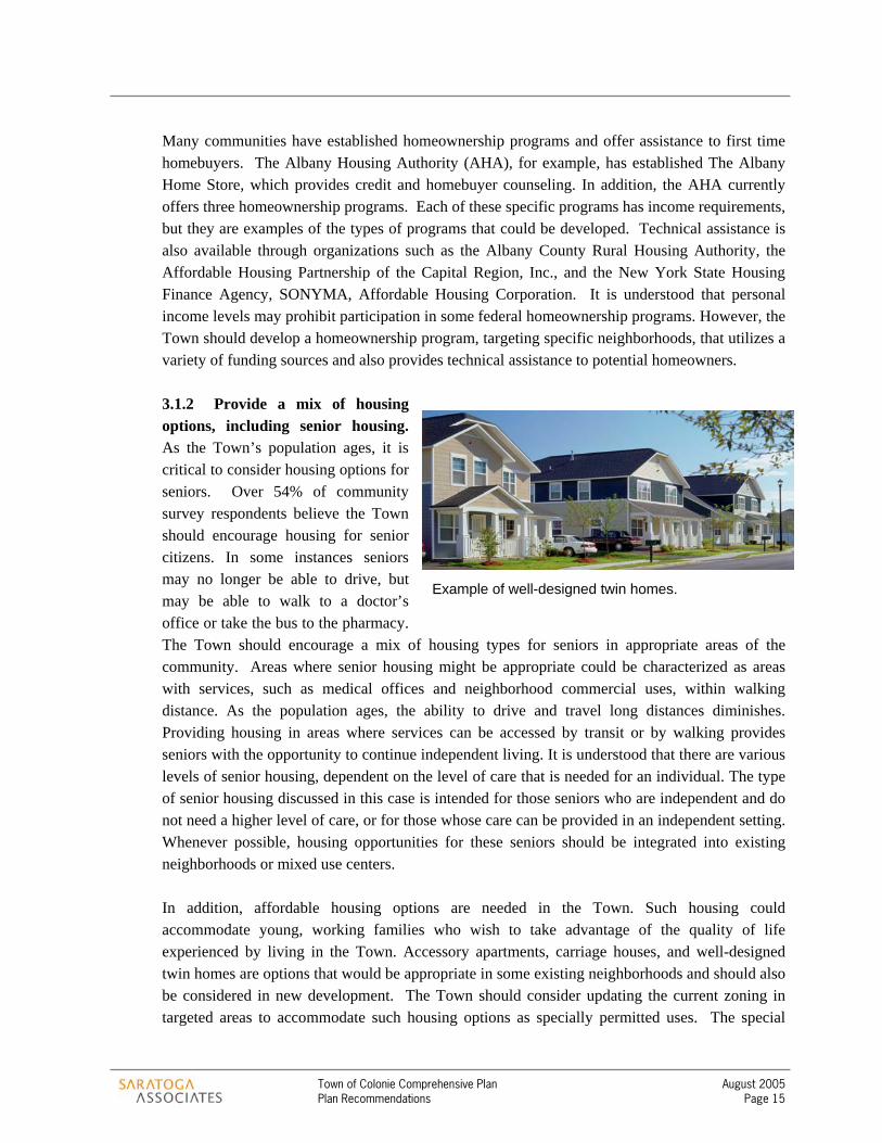
3.1.2 Provide a mix of housing options, including senior housing. As the Town’s population ages, it is critical to consider housing options for seniors. Over 54% of community survey respondents believe the Town should encourage housing for senior citizens. In some instances seniors may no longer be able to drive, but may be able to walk to a doctor’s office or take the bus to the pharmacy. The Town should encourage a mix of housing types for seniors in appropriate areas of the community. Areas where senior housing might be appropriate could be characterized as areas with services, such as medical offices and neighborhood commercial uses, within walking distance. As the population ages, the ability to drive and travel long distances diminishes. Providing housing in areas where services can be accessed by transit or by walking provides seniors with the opportunity to continue independent living. It is understood that there are various levels of senior housing, dependent on the level of care that is needed for an individual. The type of senior housing discussed in this case is intended for those seniors who are independent and do not need a higher level of care, or for those whose care can be provided in an independent setting. Whenever possible, housing opportunities for these seniors should be integrated into existing neighborhoods or mixed use centers.
In addition, affordable housing options are needed in the Town. Such housing could accommodate young, working families who wish to take advantage of the quality of life experienced by living in the Town. Accessory apartments, carriage houses, and well-designed twin homes are options that would be appropriate in some existing neighborhoods and should also be considered in new development. The Town should consider updating the current zoning in targeted areas to accommodate such housing options as specially permitted uses. The special
Example of well-designed twin homes.

Town of Colonie Comprehensive Plan August 2005 Plan Recommendations Page 16
permit requirements could ensure that such units are designed to be indistinguishable from single-family homes in the neighborhood.
3.1.3 Maintain and improve the pedestrian environment within neighborhoods. Pedestrian connections are critical to creating the sense of community that exists within these neighborhoods. Enhancing and maintaining a safe pedestrian environment is important. Though sidewalks are a costly option for every low-volume residential street, they are important on major roads, such as busy collector streets or arterials. Bike lanes or off-street bike paths may also be appropriate on the busiest of these roads. The Town should require such infrastructure as part of new development or redevelopment proposals. Connections between adjoining neighborhoods should also be required as part of all new development and redevelopment. In most cases, connections between neighborhoods (or developments) should be for both vehicular and pedestrian travel, however in some circumstances it may be appropriate to limit these connections to walking and biking paths. In locations where vehicular connections are contemplated, roadway design should be such that it limits the use of these connections as through streets. Safety considerations for adjacent neighborhoods are important and the use of traffic calming (as described below) is one technique that can help address safety concerns.
Similarly, walking and biking paths should be encouraged to connect existing neighborhoods where such connections were not originally established. Any Town owned rights-of-way or paper streets should be considered for this purpose. The Town should also work in partnership with landowners and outside funding agencies to develop and maintain such infrastructure where it is needed. The pace and extent of this effort would, of course, depend on the availability of resources and in consideration of the Town’s many priorities.
3.1.4 Establish traffic calming measures. Traffic calming is concerned with improving safety and quality of the pedestrian experience, as well as creating safer roadways for those traveling via automobile. Traffic calming usually involves reducing vehicle speeds, providing more space for pedestrians and bicyclists, and improving the overall local built environment. Traffic calming techniques could include the simple addition of street trees along the roadway, bulbouts or curb extensions, chicanes, on-street parking and landscaped medians. These techniques either physically reduce the road width or give the appearance of a narrower street, causing motorists to reduce their travel speed. It is important to recognize that these techniques are not appropriate in every situation, and qualified transportation professionals must evaluate them on a case-by-case basis.
3.1.5 Encourage the use of mass transit. Those locations throughout Colonie’s neighborhoods that are characterized by compact, higher density development could be

Town of Colonie Comprehensive Plan August 2005 Plan Recommendations Page 17
supportive of mass transit. The Capital District Transportation Authority (CDTA) operates several routes throughout the Town. The Town should coordinate with CDTA to determine opportunities for increasing ridership, and improving transit service. For example, improving the safety and quality of the pedestrian environment in the vicinity of bus routes and stops could positively impact transit use and service. Increased use of mass transit would reduce the traffic and congestion on the Town’s roadways, and would also allow those without a vehicle to be more mobile.
3.1.6 Consider neighborhood planning for specific neighborhoods. Neighborhoods, such as West Albany, would benefit from a neighborhood master plan. A neighborhood master plan would identify neighborhood specific concerns and would determine the most appropriate recommendations to address those concerns at a detailed level. The Town Board could adopt a completed neighborhood master plan as an amendment to the comprehensive plan. The Town might consider initiating such an effort in one of the Town’s older neighborhoods, developing a model process that could later be used elsewhere in the community, such as Roessleville.
3.2 NEIGHBORHOOD COMMERCIAL CENTERS Neighborhood commercial centers provide small-scale services to adjacent residential or office areas. These areas can contain a mix of uses, including small-scale retail and office, civic uses (churches, post office, etc.), and residential. Several neighborhood commercial centers already exist throughout the Town such as at the intersection of Osborne Road and Albany Shaker Road. These centers should remain small and compact to avoid spilling over into adjacent residential areas. The opportunity may exist to create additional neighborhood commercial centers in the future. If and when this opportunity or need arises, careful consideration should be given to the surrounding residential neighborhood and to the types of neighborhood commercial services needed.

Town of Colonie Comprehensive Plan August 2005 Plan Recommendations Page 18
3.2.1 Consider appropriate design guidelines for neighborhood commercial centers. According to the community survey, over 67% of the respondents agree there should be architectural design guidelines for new development throughout the Town. The Town should consider developing design guidelines for new and infill commercial or mixed-use development found within neighborhood commercial centers. Design guidelines could be incorporated into the Town’s zoning through the special use permit process. Specially permitted uses are assumed to be generally appropriate for a given zoning district, subject to special considerations. Appropriate design can be the difference between when a use is or is not appropriate, and design guidelines help to clarify how particular uses can be made to fit into the area. Among other things, design guidelines should address items such as building placement and encourage parking in the rear or to the side of buildings. Within the guidelines, some design elements should be required, while others should be suggested. For example, the guidelines could contain very specific requirements with regard to building location or the location of parking, or simply encourage the preference for multi-story buildings in neighborhood commercial centers or provide suggestions regarding appropriate building façade materials.
Examples of design guidelines addressing site organization – building placement in relation to the street, parking and buffering of parking areas and landscaping.

Town of Colonie Comprehensive Plan August 2005 Plan Recommendations Page 19
3.3 INDUSTRIAL REVITALIZATION AREAS Many opportunities exist within the Town of Colonie to regenerate and revitalize once vital industrial areas. Locations that are underutilized or even unused today, such as the First Prize Center off Everett Road, the Fuller Road and Railroad Avenue area, and several large industrial properties in the vicinity of Lincoln Avenue north of the Village of Menands and west of the City of Watervliet, could be returned to productive use. Trying to recreate value in these areas is consistent with the notion that the Town of Colonie cannot look at its remaining undeveloped land for all or most of its future development opportunities. The future revitalization of these areas should be viewed as a critical economic development opportunity, allowing the Town to grow its industrial base. Success with this type of initiative will help the Town maintain its fiscal balance, making it possible to fund necessary services and desired quality of life improvements. Before addressing individual locations in more detail (below), there are a few recommendations that could be applied to all or most of these older industrial locations. They include the following:
3.3.1 Address “brownfield” issues. The existence or possible existence of environmental contamination on older industrial properties is a major deterrent to re-investment in these properties. Several of the Town’s largest old industrial sites – including the old Delaware and Hudson property, the Al-tech site, and the Adirondack Casting site at the Town’s eastern border with the City of Watervliet and the Village of Menands – are challenged in this way. There are several programs available in New York State that could help address this issue:
> Brownfield Cleanup Program (successor to the Voluntary Cleanup Program) - Developed to
enhance private-sector cleanup of brownfields and to reduce development pressure on "greenfields." The New York State Department of Environmental Conservation administers this program.
> Environmental Restoration Program - Provides municipalities with financial assistance for
site investigation and remediation at eligible brownfield sites. The New York State Department of Environmental Conservation administers this program.
> Brownfield Opportunity Area Program – The newest of the three programs, the BOA
Program provides technical and financial assistance to municipalities and community based
Brownfields are real property, the expansion,redevelopment, or reuse of which may becomplicated by the presence or potentialpresence of a hazardous substance, pollutant,or contaminant. Cleaning up and reinvesting inthese properties takes development pressuresoff of undeveloped, open land, and bothimproves and protects the environment. - U.S. Environmental Protection Agency
Town of Colonie Comprehensive Plan August 2005 Plan Recommendations Page 20
organizations to conduct redevelopment planning for designated areas containing brownfield sites. The New York State Department of State administers this program.
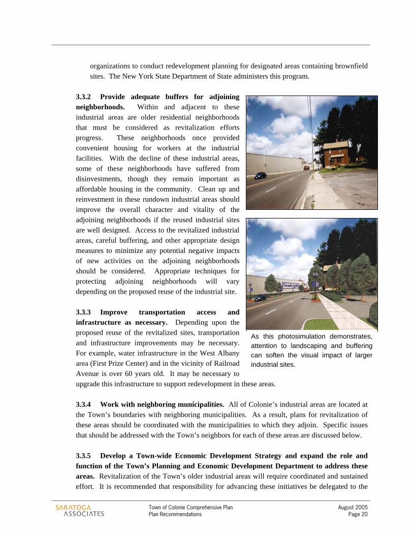
3.3.2 Provide adequate buffers for adjoining neighborhoods. Within and adjacent to these industrial areas are older residential neighborhoods that must be considered as revitalization efforts progress. These neighborhoods once provided convenient housing for workers at the industrial facilities. With the decline of these industrial areas, some of these neighborhoods have suffered from disinvestments, though they remain important as affordable housing in the community. Clean up and reinvestment in these rundown industrial areas should improve the overall character and vitality of the adjoining neighborhoods if the reused industrial sites are well designed. Access to the revitalized industrial areas, careful buffering, and other appropriate design measures to minimize any potential negative impacts of new activities on the adjoining neighborhoods should be considered. Appropriate techniques for protecting adjoining neighborhoods will vary depending on the proposed reuse of the industrial site.
3.3.3 Improve transportation access and infrastructure as necessary. Depending upon the proposed reuse of the revitalized sites, transportation and infrastructure improvements may be necessary. For example, water infrastructure in the West Albany area (First Prize Center) and in the vicinity of Railroad Avenue is over 60 years old. It may be necessary to upgrade this infrastructure to support redevelopment in these areas.
3.3.4 Work with neighboring municipalities. All of Colonie’s industrial areas are located at the Town’s boundaries with neighboring municipalities. As a result, plans for revitalization of these areas should be coordinated with the municipalities to which they adjoin. Specific issues that should be addressed with the Town’s neighbors for each of these areas are discussed below.
3.3.5 Develop a Town-wide Economic Development Strategy and expand the role and function of the Town’s Planning and Economic Development Department to address these areas. Revitalization of the Town’s older industrial areas will require coordinated and sustained effort. It is recommended that responsibility for advancing these initiatives be delegated to the
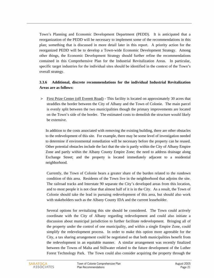
As this photosimulation demonstrates,attention to landscaping and bufferingcan soften the visual impact of largerindustrial sites.
Town of Colonie Comprehensive Plan August 2005 Plan Recommendations Page 21
Town’s Planning and Economic Development Department (PEDD). It is anticipated that a reorganization of the PEDD will be necessary to implement some of the recommendations in this plan; something that is discussed in more detail later in this report. A priority action for the reorganized PEDD will be to develop a Town-wide Economic Development Strategy. Among other things, the Economic Development Strategy should further refine the recommendations contained in this Comprehensive Plan for the Industrial Revitalization Areas. In particular, specific target industries for the individual sites should be identified in the context of the Town’s overall strategy.
3.3.6 Additional, discrete recommendations for the individual Industrial Revitalization Areas are as follows:
> First Prize Center (off Everett Road) - This facility is located on approximately 30 acres that
straddles the border between the City of Albany and the Town of Colonie. The main parcel is evenly split between the two municipalities though the primary improvements are located on the Town’s side of the border. The estimated costs to demolish the structure would likely be extensive.
In addition to the costs associated with removing the existing building, there are other obstacles to the redevelopment of this site. For example, there may be some level of investigation needed to determine if environmental remediation will be necessary before the property can be reused. Other potential obstacles include the fact that the site is partly within the City of Albany Empire Zone and partly within the Albany County Empire Zone; the need to address drainage along Exchange Street; and the property is located immediately adjacent to a residential neighborhood. Currently, the Town of Colonie bears a greater share of the burden related to the rundown condition of this area. Residents of the Town live in the neighborhood that adjoins the site. The railroad tracks and Interstate 90 separate the City’s developed areas from this location, and to most people it is not clear that almost half of it is in the City. As a result, the Town of Colonie should take the lead in pursuing redevelopment of this area, but should also work with stakeholders such as the Albany County IDA and the current leaseholder. Several options for revitalizing this site should be considered. The Town could actively coordinate with the City of Albany regarding redevelopment and could also initiate a discussion about municipal jurisdiction to further facilitate redevelopment. Bringing all of the property under the control of one municipality, and within a single Empire Zone, could simplify the redevelopment process. In order to make this option more agreeable for the City, a tax sharing arrangement could be negotiated so that both municipalities benefit from the redevelopment in an equitable manner. A similar arrangement was recently finalized between the Towns of Malta and Stillwater related to the future development of the Luther Forest Technology Park. The Town could also consider acquiring the property through the

Town of Colonie Comprehensive Plan August 2005 Plan Recommendations Page 22
Clockwise from upper left image: Examples of mixed use office and neighborhood retail; condominiums; office and apartments; townhomes; industrial redevelopment as retail and office space; infill development including neighborhood retail, office and residential.
Industrial Development Agency or some other appropriate mechanism. Control of the actual property would allow the Town to direct redevelopment of the area in a more direct manner. Future use of the area remains a question. There has been some discussion about the potential retail development of all or some of this area due to its proximity to the Everett Road exit of Interstate 90 and the Central Avenue commercial area. However, the use of this area for large-scale retail raises significant concerns related to impacts on the adjoining neighborhood, to the transportation system along Everett Road, among others. Still, it is understood that there will need to be an economic reason for someone to invest the resources that will be needed to rehabilitate and redevelop this area. It would be more appropriate to redevelop the area as a mixed-use center that would interface with the adjoining neighborhood. Well-designed office and technology space, and perhaps moderate density housing (senior housing, townhomes, condominiums, apartments), could be integrated into the site. Public spaces (such as a park or green) and smaller scale retail to serve residents and employees in the area could also be incorporated into this type of development. The area could be designed with interconnected streets/blocks and pedestrian infrastructure so that it is woven into the neighborhood. Smaller, residential scale buildings located where this site adjoins the neighborhood could also ease the transition to the surrounding residential streets. Larger parking areas or structures, and primary access to the

Town of Colonie Comprehensive Plan August 2005 Plan Recommendations Page 23
site could be oriented to the south, adjacent to the railroad tracks and highway, to further limit negative impacts on the neighborhood. Further study related to the future reuse of the area will need to occur. It is recommended that all stakeholders be invited and encouraged to participate in the planning effort, including residents from the neighborhood.
> Railroad Avenue – The Railroad Avenue corridor straddles the Town’s border with the Town of Guilderland, and the City of Albany. Though most of the buildings are still utilized, several companies have moved from the area or downsized in recent years. This trend is likely to continue as the buildings continue to age into obsolescence and the area becomes more rundown. The area is within the County Empire Zone, but there has not been much significant investment in a long time. Basic infrastructure (water and sewer) is in place, but much of it is older and in need of improvement, as are the primary roads (Railroad Avenue and Fuller Road) in the area.
Aside from the older buildings and infrastructure, a primary obstacle to reinvestment in the vicinity of Railroad Avenue is the appearance and image of this area. As a gateway to the Town of Colonie from the University of Albany area of the city, Fuller Road and Railroad Avenue create a less than desirable impression. Located just down the street from one of the primary research centers of the region’s Tech Valley Initiative, this area has great potential.
It is likely that significant investment on the public side will be necessary to enhance the redevelopment of this area. Before this can occur, the Town should identify through its Economic Development Strategy the type of industries that might be attracted to this location. For example, with its proximity to the University of Albany and Interstate 90, and even the possibility of connecting to the northern end of Route 85 (Slingerlands Bypass), it is possible that a refurbished Railroad Avenue could play a role in support of the growing technology related industries in the region. Once there is more clarity about the type of industries that should be targeted for this area, the Town should consider what level of investment is warranted here based on the potential value of redevelopment. Creative mechanisms for financing the capital improvements that will be necessary to spur investment (such as Tax Increment Financing) should also be considered. Like the First Prize Center Area, an important consideration in the redevelopment of the Railroad Avenue area should be protecting the residential neighborhood to the north toward Central Avenue. It will also be necessary to engage the City of Albany and the Town of Guilderland in the planning for this area.
> Lincoln Avenue – The Lincoln Avenue Industrial Revitalization Area is characterized by several large sites that are currently unused or underutilized. The former D&H Railroad parcel, now owned by a subsidiary of Guilford Transportation, the Al-tech facility, and

Town of Colonie Comprehensive Plan August 2005 Plan Recommendations Page 24
Adirondack Casting site are the primary pieces. There are potential environmental contamination issues at some of these locations that will need to be investigated, and if confirmed, remediated. There are also residential neighborhoods in the Town, and over the border in Watervliet that must be considered.
Due to the unanswered questions regarding potential environmental contamination of some of the individual sites in this area, the multiple property ownership that exists here, and the neighborhood and intermunicipal issues that must be considered, the Lincoln Avenue area should be considered a primary candidate for participation in the state’s new Brownfield Opportunity Area Program (BOA). Administered through the NYS Department of State, the BOA Program provides technical and financial assistance to municipalities and community based organizations to conduct redevelopment planning for designated areas containing brownfield sites. A successful application into this program would provide the necessary framework and financing to investigate the multiple issues in a comprehensive way. The Town should seek guidance from the Department of State on whether or not it would be eligible for the BOA program. Among other things, redevelopment planning for this area must consider the potential future uses for the various sites. Based on the area’s proximity to Interstate 787, and the presence of Federal Express here, it appears that warehousing and distribution could be logical target industries. Further market analysis should be conducted to determine whether this or other target industries are indeed appropriate. A critical issue that will need to be resolved is local access to these sites. Though the area is proximate to an interstate highway exit, local access to these sites from the exit is through 1st Street in the City of Watervliet. This street is primarily residential, and ill suited to be the primary point of access for a possible future industrial park, especially one that is oriented to distribution. Developing an alternative access, perhaps utilizing the entrance to Federal Express from Route 32, should be considered. Finally, because the area is adjacent to neighborhoods in both the City of Watervliet and the Town, buffering future industrial use will be very important here. The Town should consider altering its green space requirements to decrease the emphasis on green space for individual parcels in favor of much more substantial greening at entranceways to a possible future industrial park, and between the industrial park and adjoining residential neighborhoods.
3.4 PRIMARY TRANSPORTATION CORRIDORS ROUTE 5 – CENTRAL AVENUE The New York Route 5 corridor has the greatest arterial traffic volumes and the highest number of transit riders in the Capital Region, according to the New York Route 5 Land Use and Transportation Study conducted by the Capital District Transportation Committee (CDTC). CDTC is the Capital

Town of Colonie Comprehensive Plan August 2005 Plan Recommendations Page 25
Region Metropolitan Planning Organization or MPO. In its role as MPO, CDTC is engaged in various studies addressing land use and transportation along major corridors in the region, among other activities. The Town of Colonie, as a member of CDTC’s Policy Board and Planning Board, is actively engaged in the region’s transportation-related decision making. The New York 5 Study was initiated in recognition of the importance of this corridor and completed in September 2001. The recommendations that came from this study are generally incorporated into this comprehensive plan. The segment of Route 5 located within the Town of Colonie is characterized as a suburban strip. This area provides regional retail services along the strip itself and residential development along the interior of the strip. While a good portion of the strip is suburban in nature, there are nodes that are more densely developed, such as near Wolf Road and New Karner Road.
3.4.1 Establish a Business Improvement District. Pooling resources from property owners in order to coordinate ongoing maintenance and improvement activities can enhance the success of commercial areas. The creation of a Business Improvement District (BID) may be appropriate at various locations within the Town, such as area along Central Avenue. A BID provides a mechanism for property owners and business owners to raise funds for supplemental services, such as street and sidewalk maintenance, beautification, prospecting, marketing, and business recruitment and retention. It could also assist in developing public parking or coordinating shared parking arrangements. Organizing a BID requires property owners to tax themselves to raise funds and establish an operating budget under their control to provide for the additional services.
3.4.2 Encourage the use of transit. The corridor currently has the density and mix of uses that are supportive of mass transit. It is recognized that several transit stops already exist along this corridor and are well-used. However, the New York 5 Study suggests the use of Bus Rapid Transit (BRT) along this corridor to enhance the efficiency and attractiveness of the system, reduce vehicular congestion, improve circulation and increase transit ridership. BRT provides the service associated with Light Rail Transit, but at lower capital costs and operating costs. A BRT system also offers more flexibility. The Town should work to encourage the use of transit through its land use practices.
3.4.3 Improve the pedestrian environment. The New York 5 Study also suggests various improvements to the pedestrian environment along the corridor. Safety, sociability, and quality of life are important aspects of a vibrant pedestrian environment. The Study recommends traffic calming measures to assist in creating a more pedestrian oriented corridor, such as narrow streets, vertical deflectors (such as speed bumps), short turning radii around corners, bulbouts, angled parking and chicanes. In addition, streetscape improvements, such as pedestrian scaled signage and street lighting, are also recommended.
Town of Colonie Comprehensive Plan August 2005 Plan Recommendations Page 26
3.4.4 Consider the use of “form based code.” Design guidelines are one technique a community can utilize to address the form of its development. A more prescriptive technique to address the form of development is the use of form based code. A “Form Based Code” could be used as an alternative to the creation of design guidelines for mixed-use nodes within Colonie, and should be considered for mixed use nodes along Central Avenue. Form based codes place less emphasis on use regulations than do conventional zoning documents. Instead, form based codes are more flexible about use, perhaps only prohibiting certain uses that are clearly inappropriate, while being very prescriptive about architecture and urban design. There are several approaches to form based code and the Town should consider which is most appropriate as the zoning regulations are updated.
One type of form based code is called the Transect. The Transect is a concept developed by Duany Plater-Zyberk & Company, a Florida based town planning firm. As the figure below illustrates, the Transect represents the continuum of development form from rural to urban. Each point along the continuum has particular design elements that characterize that type of development. For example, the T3 Suburban Transect has different design characteristics than the T6 Urban Core Transect. Streets in suburban areas tend to be more curvilinear in form, buildings are usually detached and set back from the street, etc. In the urban core, streets form regular blocks, buildings tend to be attached and located close to the sidewalk at uniform build-to lines, streetscapes are more formal, etc. These general design elements are described in the transect graphic below.
From this general continuum, Duany Plater-Zyberk & Company have developed a set of standard design parameters for each transect. These standards, usually illustrated in simple to read tables, address a host of design elements such as the type of streets and public spaces, the building position, building type, and general architectural characteristics that are appropriate for each transect. Of course these elements must be tailored to the specific circumstances of individual communities.
For example, the City of Saratoga Springs applied this approach to its “special development areas.” These six areas, one of which is the downtown, are places where the City’s comprehensive plan calls for the encouragement of high density, mixed-use development. To implement this, the three most urban categories of the Transect were utilized (T4 through T6). The actual dimensions that apply to the different design elements within these transect zones were tailored to meet the characteristics of Saratoga Springs.
In Colonie, the Transect concept could be modified to apply to the mixed-use areas along Central Avenue. For example, the T6 category could be tailored to fit the corridor’s most “urban” areas along Central Avenue, near the Albany City line.
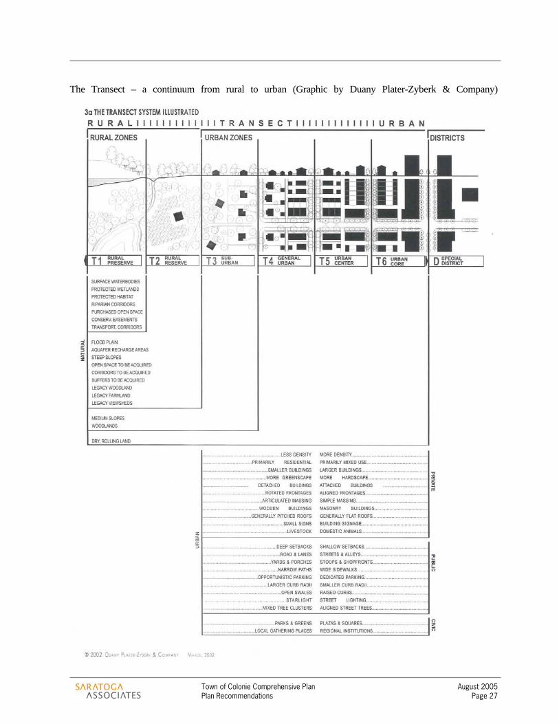
Town of Colonie Comprehensive Plan August 2005 Plan Recommendations Page 27
The Transect – a continuum from rural to urban (Graphic by Duany Plater-Zyberk & Company)

Town of Colonie Comprehensive Plan August 2005 Plan Recommendations Page 28
ROUTE 7 – ROUTE 2 The Town of Colonie and the Capital District Transportation Committee (CDTC) are currently undertaking a study of the Route 7 – Route 2 corridor from Vly Road to the Latham Circle. This is a heavily traveled corridor that experiences traffic congestion issues at specific locations. As a result of the transportation issues and the continuing development pressure in this corridor, in the summer of 2004 the Town Board enacted a temporary development moratorium for portions of the corridor west of I-87 (the Northway). The moratorium was intended, in part, to give the Town time to advance the Route 7 – Route 2 Corridor Land Use/Transportation Linkage Study. After its reconstruction in 1990, Route 7 – Route 2 became a more attractive transportation route and potential location for development. The corridor plays an important role as an east-west transportation route in the Capital Region. While there are transportation improvement projects planned for the Route 7 – Route 2 corridor over the next few years, it is unlikely that a major project to increase capacity will be undertaken. An investment to increase capacity by widening Route 7 – Route 2 would be a costly endeavor, and as the graphic at right indicates, widening the road (as a single solution) would not improve congestion issues in the long-term. As a result, the Route 7 – Route 2 Study moves beyond traditional transportation analysis and focuses on the land use side as well. The study assesses the impact of various types of land uses on the transportation infrastructure. Currently, multiple parcels of land in the corridor are poised for development or redevelopment. In addition to the type of land use, the form of development can have a significant impact on the function of the corridor. Design can impact driving habits and ultimately traffic generation. As stated previously, there are transportation improvements planned or occurring along the corridor. The recently completed Wade Road Extension is a positive improvement to the traffic congestion in that portion of the corridor. In addition, the NYSDOT is currently developing plans to improve the Northway Exit 6. While many alternatives are being considered, a Single Point Urban Interchange (SPUI) is a primary alternative at this stage of the study. The Route 7 – Route 2 Study will recommend additional transportation solutions such as access management, internal/parallel access roads, intersection improvements, improved pedestrian and bicycle connections, and improved transit.
Source: “How to…Link Land Use andTransportation Planning” (2003), StraffordRegional Planning Commission, Dover, NewHampshire

Town of Colonie Comprehensive Plan August 2005 Plan Recommendations Page 29
It is recommended that the concepts and recommendations described in the Route 7 – Route 2 Study be incorporated into the comprehensive plan. The following are highlights of recommendations from the study. For specific recommendations, the Route 7 – Route 2 Study should be referenced.
3.4.5 Create gateways to enhance significant locations along the corridor. Gateways provide a sense of arrival and can also function to calm traffic at key locations. A landscaped median or boulevard treatment similar to the boulevard gateway along Route 9 in Saratoga Springs, New York would be recommended. This type of gateway treatment would not only provide aesthetic appeal and help to slow traffic, but also provide a pedestrian refuge. It is recommended that gateways be established at the following locations along the corridor:
> East Gateway – located between the Latham Circle and the Adirondack Northway (I-87) > Gateway at the Northway – located directly west of the Adirondack Northway (I-87) > Albany-Shaker Road Gateway – located at the intersection of Route 7 and Albany-Shaker
Road and clearly identifying the link between Albany International Airport and the community
> West Gateway – located at Vly Road and continuing eastward to allow for safe pedestrian and bicycle crossing at Albany Shaker Road
3.4.6 Encourage the use of transit. Several transit stops already exist along this corridor. Making these stops more convenient to places of work or residential neighborhoods might encourage usage. In addition, safety factors need to be considered for transit riders. Appropriate bus pull-offs should be incorporated into the roadway and well marked sidewalks and crosswalks should also be a priority in areas adjacent to and leading to transit stops.
3.4.7 Implement access management techniques. Access management includes techniques that effectively limit the number of access points or curbcuts along a roadway corridor. Limiting the number of driveways, consolidating driveways or replacing a center-turn lane with a raised median are common techniques. Access roads are another access management technique in which a parallel road would be created to providing an alternative route to access the businesses and services that front onto the main corridor. An access road would redirect motor vehicles to intersections with appropriate traffic controls and assist in alleviating congestion and improving traffic flow on Route 7 and Route 2.
Access management provides many benefits in addition to improving traffic flow. Reducing the number of curbcuts reduces the number of potential conflict points between pedestrians and vehicles. This also creates a safer environment for bicyclists. In creating a landscaped raised median, pedestrian crossing opportunities are enhanced (the median serves as a pedestrian refuge island) and the aesthetics of the corridor are enhanced as well. In addition, accommodating the disabled is easier, as the need for special treatments at driveways along the corridor is reduced. Limiting future access to Route 7 – route 2 from individual development sites is a high priority. The Town is working with the CDTC through the Route 7 – Route 2 Study to develop specific

Town of Colonie Comprehensive Plan August 2005 Plan Recommendations Page 30
access management recommendations and to identify locations for future access roads and internal road networks in areas where significant development potential remains.
Some of the specific locations along the corridor that present opportunities for access roads are located on the south side of the Route 7, and include but are not limited to the following: > Rensselaer Avenue west to Wade Road, and Wade Road west to NYSUT Drive. > Lear Jet Lane west and north to NYSUT Drive.
3.4.8 Encourage a greater mix of uses and an emphasis on design in specific nodes where additional development or redevelopment is anticipated. Some areas of the corridor - especially the area between NYSUT Drive and Exit 6 of the Northway, and the area from Albany-Shaker Road west to Vly Road - still contain significant amounts of developable land. With their location directly on Route 7, these areas are under significant pressure for development. A primary concern is that these areas will be developed for large-scale retail similar to what has occurred to the east, and immediately to the northwest of Exit 6. The Route 7 – Route 2 Study will recommend that these areas be developed instead with a mix of uses. The specific uses – offices, small to moderate scale retail, higher density residential such as senior housing, and perhaps hotels and entertainment uses – will vary depending on the location. In addition to the recommended land use changes, the plan will suggest design elements to improve the appearance of sites and structures in these areas, and to create environments that accommodate vehicles while also enhancing the safety and comfort of pedestrians. Interconnected street networks and walkability will be high priorities in these mixed-use nodes.
3.4.9 Encourage the use of buffers between commercial development and existing residential development. The Route 7 – Route 2 corridor is a very diverse corridor with retail, commercial, and residential uses. In areas where residential uses are adjacent to commercial or retail uses, landscaped buffers should be in place. The Town should encourage buffers to be preserved or created as new development or redevelopment occurs.
3.4.10 Create connections and pathways. The opportunity exists to connect neighborhoods through trails and to connect to the Mohawk Hudson Bike Hike Path. There are areas along the corridor that are environmentally constrained by stream corridors and not ideal for development. However, such areas could be developed as walking and biking trails. The Town, through the Planning and Economic Development Department or the Parks and Recreation Department, could partner with local and regional groups such as the Albany County Land Conservancy, the Mohawk River Community Partners, the Capital District Transportation Committee or the Initiative for Healthy Infrastructure at the University at Albany to identify and develop connections. Local volunteer groups would also be resources to assist in long-term maintenance.
3.4.11 Consider the redevelopment of underutilized malls as hybrid malls. There are locations along the Route 7 corridor where the opportunity exists to redevelop underutilized malls. Such malls may still be active, however these retail centers are not currently as active as

Town of Colonie Comprehensive Plan August 2005 Plan Recommendations Page 31
they once were. One concept gaining momentum in the retail marketplace is the concept of a hybrid mall. A hybrid mall blends a conventional enclosed mall with open-air retail centers. Hybrids are attractive, even in regions prone to inclement weather. Consumers, developers and communities recognize the benefits associated with this type of development. The outdoor aspects of a hybrid mall may include a mix of restaurants, entertainment, offices and public spaces. Successful projects typically include nighttime draws and ultimately create a destination. The hybrid mall approach would allow this retail center to recapture a regional draw.
The following illustration represents Deerfoot Meadows, a hybrid mall in Canada.
ROUTE 9 – LOUDON ROAD Route 9, also known as Loudon Road, is a primary north-south route in the Town. This road is characterized with a mix of land uses and a variety of architectural designs. Land uses include residential, commercial, and retail along the length of the corridor. The corridor is also home to Town Hall and the Siena College campus. Some of the primary challenges for this corridor are transportation related, including traffic congestion in specific locations and the abundance of curb cuts from Route 9 to individual sites. There are also issues related to the proximity of commercial uses directly along Route 9 and residential neighborhoods to the rear. And finally, there is a concern that the corridor will become one long commercial strip all the way to the Town’s northern border.
Source: Streetwise, Vol.22 No. 2 January 08, 2004
Town of Colonie Comprehensive Plan August 2005 Plan Recommendations Page 32
The section of Route 9 from just north of Maxwell Road to the Latham Circle has been a very successful commercial area in the Town for decades. More recently, portions of the “miracle mile” have become somewhat aged. As these locations are spruced up or redeveloped, there will be opportunities to improve the overall appearance and function of the corridor. Recommendations for commercial areas (Section 3.7 below) will help to ensure that as this occurs, attention will be paid to good access management, building and site design, and the ability of the corridor to serve vehicles, bikes, pedestrians, and transit.
3.4.12 Encourage development of a Mixed-Use Node along Route 9 between Maxwell Road and the Latham Circle. There are few large parcels of land remaining for development in this corridor. As an alternative to continued retail only development along the entire length of the “miracle mile”, the Town should look for opportunities to encourage the development of a small mixed-use center. This could be accomplished through redevelopment of an existing site in the form of a pedestrian-friendly “village” center. The node could perhaps accommodate small-scale retail, office, moderate density residential, and entertainment uses, creating a sense of place for the Newtonville area.
3.4.13 Create connections between neighborhoods and improve the pedestrian environment. The most basic solution to improving the pedestrian environment is the addition of sidewalks and crosswalks, at appropriate locations frequently used by pedestrians. One appropriate location might be near Siena College. Sidewalks connecting Siena College to the strip development and other services along Route 9 would create an improved safety condition for students.
The Town should encourage pedestrian connections and sidewalks along Route 9. To further enhance the safety of the pedestrian environment, well marked crosswalks and access management should also be encouraged. Curb-cuts, for example, increase the potential for pedestrian and vehicle conflicts. Currently, an overabundance of curb-cuts exist on Route 9. Access management in the form of shared driveways and shared parking can be effective in reducing curb-cuts. When new development occurs or when alterations are made to existing sites, the Town should consider requiring pedestrian facilities or shared driveways. In other cases, Colonie could consider paying for pedestrian improvements, dependent on the available resources. Funding is often available from other agencies or organizations.
3.4.14 Consider traffic calming along the corridor. Traffic calming is a technique utilized in many communities to slow vehicular traffic. This technique uses a variety of tools, such as landscaped medians, bulbouts, and street trees. Coupled with improvements for the pedestrian environment along Route 9, this recommendation would assist in creating a corridor that is both friendly and welcoming to the pedestrian and functions well for vehicles.
Town of Colonie Comprehensive Plan August 2005 Plan Recommendations Page 33
3.5 MIXED USE NODES
3.5.1 Encourage mixed use nodes at transit stops along Central Avenue. The Route 5 Study focused on regional mixed use nodes supported by bus rapid transit (BRT). The Plan Recommendations map suggests the location of such nodes. (Note: these are the nodes as described in the Route 5 Corridor Study). Allowing for a mix of office, residential and retail development should be encouraged. The form of development at these locations should also be considered. Pedestrians and bicyclists should be considered and appropriate facilities incorporated into the design of the roadway. To this end, buildings should be placed near the street, parking should be placed in the rear with consideration of abutting uses, sidewalks should be well-maintained and perhaps a boulevard-style roadway treatment is necessary in specific locations to provide a pedestrian refuge when crossing the multi-lane roadway.
3.5.2 Encourage mixed use nodes at key locations throughout the Route 7 / Route 2 corridor. Similar to the mixed use nodes along the Central Avenue Corridor, office, residential and some small scale retail would be encouraged. Such nodes are illustrated on the Plan Recommendations Map and include areas such as the intersection of Route 7 and Wade Road; the Vly Road area and the areas near Albany-Shaker Road.
3.5.3 Consider developing the Wolf Road Corridor as a mixed use node or Town Center. The Wolf Road corridor is already an important activity center in the Town. With a variety of uses ranging from office and commercial to retail and services, Wolf Road has the potential to become a Town Center in the future. The recent addition of sidewalks to Wolf Road is a step in the right direction. Additional pedestrian facilities and attention to the form of development taking place in the corridor will be key to its success as a center. It is important that future improvements to Wolf Road balance the capacity of the road infrastructure, sewer and water capabilities with aesthetics and traffic calming efforts. The corridor must function well to be successful.
The use of mass transit and an increased mix of uses should be encouraged in this area. In fact, higher densities could be encouraged along Wolf Road, provided the sewer and water infrastructure exists to support such densities. The Town could consider the placement of senior services or senior housing, in addition to the Beltrone Living Center, in this location.
3.6 OFFICE MIXED USE AREAS The Plan Recommendations Map identifies several locations as office mixed use areas. These are areas where office uses currently exist, such Corporate Woods or along British American Boulevard, and where there is an opportunity to provide a wider mix of uses in support of the existing, and any future, office development. Small-scale services, such as dry cleaners, print shops or restaurants, could support the employees in these areas. Though these areas are not envisioned to include

Town of Colonie Comprehensive Plan August 2005 Plan Recommendations Page 34
residential uses, the expanded services provided in them might also be convenient for adjacent residential neighborhoods.
3.6.1 Develop design guidelines for office mixed use areas. Similar to other mixed-use areas in the Town, the development of design guidelines should be considered for the office mixed areas. Design guidelines can be incorporated into the Town’s zoning through the special use permit process. Specially permitted uses are assumed to be generally appropriate for a given zoning district, subject to special considerations. Among other things, design guidelines should address items such as building placement and encourage parking in the rear or to the side of buildings. Design guidelines can also address the location of sidewalks and assist in creating pedestrian connections to adjacent residential uses.
3.7 COMMERCIAL RETAIL AREAS The commercial retail areas, as illustrated on the Plan Recommendations Map, are located primarily along Route 9 north of Maxwell Road near the I-87 Exit 6 area - the Latham Farms and Latham Retail Center developments. These particular areas are primarily characterized by large scale retail development. While these commercial retail areas provide needed services to Town residents, many residents have expressed through the public outreach process concern over the amount of large scale development in the community.
3.7.1 Update zoning regulations within the commercial retail areas to include design guidelines. The zoning regulations should address the form and function of development in these areas. Design guidelines should illustrate appropriate site design, site organization and architectural standards. Despite being large developments, large scale retail could be enhanced to have more character and more of an identity. The Town should be clear from the beginning what is expected of the developer regarding design of the site and building. This might assist in expediting the development process and the resulting predictability may also encourage development in these areas.
Site design should emphasize the pedestrian as well as the automobile. Prominent crosswalks should be located at appropriate controlled intersections and sidewalks should be developed along the roadway, especially as the areas continue to build out. The sidewalk should be separated from the road with a wide planting strip. The planting strip would serve to buffer pedestrians from automobile traffic. Within the parking lots, substantial landscaping to reduce continuous areas of impervious surface, pedestrian walkways, and other such improvements should be required. In addition, smaller buildings oriented to the sidewalk and street, could improve the pedestrian environment along roadway corridors and buffer the large parking areas that large-scale stores require. Design themes for all buildings should be consistent. In addition, utility and service facilities should be placed in visually unobtrusive locations.
Town of Colonie Comprehensive Plan August 2005 Plan Recommendations Page 35
These areas should function well, not only from a vehicular point of view, but also from a transit and pedestrian view as well. Access management techniques could be utilized to reduce traffic congestion and potential conflict points with pedestrians and through traffic. Access management consists of a series of standards that manage (and minimize) the number of access points and curbcuts on the public road system. The purpose of access management is to allow for development to occur, while preserving the flow of traffic in terms of speed, capacity and safety (traffic includes pedestrians and bicyclists).
3.8 AIRPORT BUSINESS AREA The Airport Business Area is an area characterized by a variety of uses including residential, office and commercial. In addition, there are many businesses associated with the transportation infrastructure, such as warehousing, distribution and truck terminals. The Albany International Airport (the Airport) is a valuable economic force in the Town and region, providing over 10,000 full-time jobs. The Airport is home to 14 commercial airlines and 4 cargo services. This major transportation hub connects the capital region with the world. The Airport has actively sought to be a ‘good neighbor’ within the Town of Colonie. The Town of Colonie has worked with the Airport regarding the impacts of noise on surrounding neighborhoods. The Town has adopted an Airport Noise Overlay District as recommended in the 2003 Noise Compatibility Study Update, which was completed by the Airport. Such action has served to preserve property values and reduce conflicts within the Airport Area.
3.8.1 Implement noise compatibility measures as identified in the 2003 Noise Compatibility Study Update. In accordance with federal regulations, the Airport completed an FAR Part 150 Noise Compatibility Study Update in April 2003. Within this study, several recommendations are suggested to assist in reducing the impacts of the Airport and Airport-related activities. The Town ahs already implemented some recommended measures and should work to implement others, such as requiring the recording of fair disclosure covenants with the deeds of lots in new subdivisions, encouraging the use of sound insulation materials for noise-sensitive buildings, and promoting site planning for noise abatement.
3.8.2 Encourage the Albany International Airport to maintain acquired properties as open space. The Airport has for some time been purchasing undeveloped properties to assist with preventing obstructions and also to prevent uses of land that are inconsistent with airport activities. The Town could encourage the Airport, once it purchases these properties and removes any obstructions, to continue maintaining these properties as open space.
3.8.3 Rezone surrounding parcels to more appropriate land uses and encourage ancillary services to support the Airport and economic development within the region. The Town should consider rezoning parcels located within the airport area to uses that are more compatible with the Airport. In addition, such a rezoning could also work to encourage economic
Town of Colonie Comprehensive Plan August 2005 Plan Recommendations Page 36
development. The Town Planning and Economic Development Department and the Airport could coordinate with one another on future economic development activities. Partnerships could be established as both entities look for opportunities to facilitate the growth of businesses and to enhance employment opportunities in the Town. In addition, discussions could take place about how to assist in placing parcels used for the purposes of economic development back on Town tax rolls. This would help to offset the public services provided to such properties. The Town could establish, for example, a Payment In Lieu Of Taxes (PILOT) program when coordinating with the Airport. This program could be a demonstration project for future partnerships and cooperative efforts. The IDA could also be a partner in this effort.
3.9 MOHAWK RIVER REVITALIZATION AREA The Town of Colonie is fortunate to have approximately 10 miles of waterfront along the Mohawk River. Recognizing the importance of this waterfront the Town, in coordination with the Mohawk River Community Partners of Colonie, Inc. (MRCP), is developing a Waterfront Revitalization Strategy and Action Plan. This Revitalization Strategy has been funded by a grant from the New York State Department of State Division of Coastal Resources under its Local Waterfront Revitalization Program. The study addresses a variety of issues including the health of the river itself, the adjacent land uses, the recreational uses of the river, the economic development opportunities of the river, the use of the river as a transportation route, and more. The Mohawk River Revitalization Area, as illustrated on the Map, is the boundary of the study area identified in the Waterfront Revitalization Strategy and Action Plan.
3.9.1 Embrace the recommendations of the Mohawk River Revitalization Strategy. The comprehensive plan supports the findings and recommendations in the Mohawk River Revitalization Strategy. While the study includes a more detailed description of each recommendation, the following are the general recommended actions discussed in the study. It would be appropriate for the Town to endorse and implement these actions, as it deems appropriate. In fact, many of these actions are consistent with those recommended in this comprehensive plan
> The Town of Colonie’s Comprehensive Plan should include a Town-wide Open Space Plan
component that serves to protect viewsheds and environmentally sensitive lands, including floodplains and wetlands.
> The Town of Colonie in partnership with MRCP should develop an Economic Development Strategy for the Study Area based on recreation and heritage tourism.
> The Town of Colonie should develop a Recreation Plan that includes the Mohawk River and its amenities.

Town of Colonie Comprehensive Plan August 2005 Plan Recommendations Page 37
> MRCP should form a Colonie Heritage Partnership, which would identify sites and stories, identify audiences, develop appropriate signage and exhibits, create a thematic framework, and work in partnership with local and regional funders and experts in interpretation.
> Enhance the sense of community for the existing neighborhood in the Study area, including establishing pedestrian connections in and between neighborhoods.
> Support farm operations, land stewardship and economic vitality of the Study Area. > Support traditional uses of land, such as hunting, fishing, and trapping consistent with all
applicable laws. > Establish formal, purposeful partnerships with municipal neighbors and state and local
program sponsors. > Explore partnerships with local, state and national land trusts to accomplish conservation
goals. > Protect scenic viewsheds throughout the Study Area through scenic overlay designations,
buffer zones and other conservation planning tools. > The Town of Colonie should adopt necessary land use regulations to support the
Recommended Actions outlined in the Revitalization Study. > MRCP will continue its role in outreach and public education by providing a forum for
discussing issues and projects affecting the Study Area.
3.9.2 Encourage the use of conservation subdivision design for the entire area, especially in the vicinity of the Delphus Kill. Conservation subdivision design considers the sensitive environmental features of the area. Conservation Subdivision Design is a type of clustering that addresses the form of development. By separating the concept of density from the concept of lot size, the Town could permit flexible lot-sizes that facilitate creative subdivision design in harmony with the landscape. In addition to the environmental and viewshed benefits of allowing homes to be situated in a creative manner, a network of conserved open lands can be created in the process. These conserved lands, for example, might function as wildlife corridors or create buffers. In addition, the conserved lands could provide benefits related to stormwater management. This type of benefit will become increasingly important as the Town addresses the Phase II Stormwater Rule required by the New York State Department of Environmental Conservation. A more detailed description of the Conservation Subdivision Design approach is provided in Section 5 – Open Space and Recreation Plan.
A required open space set aside should also be established. In locations where sewer and water
infrastructure is already available, or could be made available, a required minimum open space set aside of perhaps 50% could be established for conservation subdivisions. Where wells and septic systems will be utilized, the minimum open space set aside could be reduced to perhaps 40%. These minimum open space set asides would ensure meaningful open space conservation, and still allow creative subdivision design.

Town of Colonie Comprehensive Plan August 2005 Plan Recommendations Page 38
3.9.3 Establish an Incentive Zoning mechanism. Such a mechanism would allow for modest density increases in exchange for specified public benefits – Incentive Zoning establishes a framework for negotiation between the Planning Board and the developer of a proposed project. Under Incentive Zoning, the Planning Board would work within established guidelines to grant a developer additional housing units above the base density in exchange for the developer’s agreement to provide specified public benefits. The Incentive Zoning provision must be carefully written to set clear parameters about the extent of the potential density bonus and to specify the public benefits that are required in order to receive the density bonus. The review process established under the incentive zoning provision would ensure that the benefits gained are worth the incentives provided.
3.9.4 Revise zoning regulations in the Delphus Kill area. The Delphus Kill area is one of the relatively few remaining areas for development in Colonie. However, slopes and environmentally sensitive characteristics are potentially limiting for development in this area. If development were to occur, it is recommended that only residential development be considered north of Pollack Road. The use of conservation subdivision design would consider special environmental features, while still allowing for some development to occur. An emphasis on residential development with some moderate density, mixed use office would be appropriate in areas south of Pollack Road when development occurs in this location. The use of conservation design would be required in this area as well. This area could be considered more of a transition area and could provide some small scale neighborhood commercial development serving existing residential neighborhoods in the vicinity. In addition, those areas remaining as open space could provide future opportunities for biking and hiking corridors.
The impacts of any change in zoning within the Delphus Kill area or other areas in the Town would be reviewed as part of the State Environmental Quality Review (SEQR) requirements associated with any zoning change. Similarly, the impacts (such as traffic) of future development within this area would require project and site specific review under SEQR and would occur if and when development is proposed.
3.10 PINE BUSH AREA The Pine Bush Area on the Plan Recommendations Map is characterized by properties located within and adjacent to the Albany Pine Bush Preserve in the western portion of the Town. The Albany Pine Bush area contains sandy, well-drained soils characterized by ecological communities and plant species adapted to fire and dry conditions. This area is most well-known for its support of the Karner Blue Butterfly, a state and federally listed endangered species. The Pine Bush Area also supports the globally rare pitch pine and scrub oak barrens. In addition to the ecological importance of the area, a mix of commercial and low-density residential uses exists here. Currently, 700 acres of protected Albany Pine Bush Preserve lands are within the Town of Colonie and located primarily in the area outlined on the Plan Recommendations Map. These protected lands are part of a 3,000-acre recreational resource that is open to the public. Within the Preserve, there are

Town of Colonie Comprehensive Plan August 2005 Plan Recommendations Page 39
18 miles of recreational trails allowing for a variety of non-motorized uses. These trails create connections to adjacent neighborhoods and municipalities. The Preserve also offers educational opportunities including self-guided exploration and interpretative programs. In addition, an environmental education facility is slated to open soon. In 1988, New York State established the Albany Pine Bush Preserve Commission and the Albany Pine Bush Preserve. The Commission is a unique partnership of public, private and non-profit organizations responsible for managing the Preserve for public use and protecting its sensitive resources. The Town of Colonie is an active member of the Commission and works together with the Commission regarding development and open space protection activities within the Pine Bush. For example, the Town has sponsored an initiative promoting the use of indigenous plant species for commercial development as part of the development approval process. As a result, local nurseries now carry indigenous plant species. In 2002, the Commission developed a Management Plan for the Preserve and the Town Board, as a member of the Commission, agreed to support the Management Plan. The Management Plan identified areas recommended for full protection and partial protection. The Town should utilize the Management Plan as a resource when identifying areas to consider for open space conservation. For example, those areas identified for full protection within the management plan could be considered priority open space conservation areas.
3.10.1 Revise the zoning regulations in the Pine Bush Area. The current industrial zoning designation for much of the Pine Bush Area should be reconsidered. Low-density residential, office and pockets of light industrial uses would be more appropriate. As zoning for the area is revised following adoption of this plan, the Town will identify an appropriate density that reasonably allows for some development to occur and still carefully considers the special resources of the Pine Bush. To that end, the use of conservation subdivision design should be required for all development – residential as well as office or light industrial. This form of development would maintain open spaces, provide an opportunity for wildlife corridors to be maintained and hopefully prevent significant fragmentation of important habitat. Revising the underlying zoning, as described above, is one of several tools to assist in conserving significant resources while allowing some development to occur. The Town and the Pine Bush Commission work together as development applications for this area are reviewed. The Commission currently has an opportunity to review all development plans for activities located within the Pine Bush Preserve and this practice will continue. This collaboration and cooperation assists both the Town and the Commission in their conservation objectives.
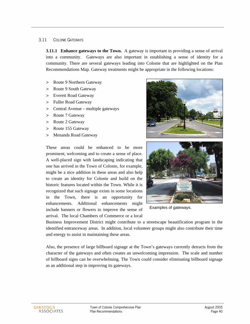
Town of Colonie Comprehensive Plan August 2005 Plan Recommendations Page 40
3.11 COLONIE GATEWAYS
3.11.1 Enhance gateways to the Town. A gateway is important in providing a sense of arrival into a community. Gateways are also important in establishing a sense of identity for a community. There are several gateways leading into Colonie that are highlighted on the Plan Recommendations Map. Gateway treatments might be appropriate in the following locations:
> Route 9 Northern Gateway > Route 9 South Gateway > Everett Road Gateway > Fuller Road Gateway > Central Avenue – multiple gateways > Route 7 Gateway > Route 2 Gateway > Route 155 Gateway > Menands Road Gateway These areas could be enhanced to be more prominent, welcoming and to create a sense of place. A well-placed sign with landscaping indicating that one has arrived in the Town of Colonie, for example, might be a nice addition in these areas and also help to create an identity for Colonie and build on the historic features located within the Town. While it is recognized that such signage exists in some locations in the Town, there is an opportunity for enhancements. Additional enhancements might include banners or flowers to improve the sense of arrival. The local Chambers of Commerce or a local Business Improvement District might contribute to a streetscape beautification program in the identified entranceway areas. In addition, local volunteer groups might also contribute their time and energy to assist in maintaining these areas. Also, the presence of large billboard signage at the Town’s gateways currently detracts from the character of the gateways and often creates an unwelcoming impression. The scale and number of billboard signs can be overwhelming. The Town could consider eliminating billboard signage as an additional step in improving its gateways.
Examples of gateways.
Town of Colonie Comprehensive Plan August 2005 Plan Recommendations Page 41
3.12 TOWN-WIDE RECOMMENDATIONS
CONNECTIONS AND PATHWAYS 3.12.1 Develop a Town-wide Sidewalk Plan. Throughout the comprehensive planning process, participants identified the need for additional connections between residential neighborhoods and also between services. Of those responding to the community survey, nearly 70% felt there were not enough sidewalks and this lack of sidewalks is a serious problem. A Town-wide sidewalk plan would serve to identify appropriate locations for new sidewalks and locations where sidewalk connections or improvements are necessary. It is understood that sidewalks may not be appropriate in all locations and the maintenance costs of sidewalks should be carefully considered. Additional study into the proper locations of such formal connections is recommended.
Possible locations where sidewalks might be appropriate would be on streets that connect neighborhoods to recreation facilities or neighborhood services. Sidewalks could be added to Buhrmaster Road or Mill Road, for example, to enhance connections to the Mohawk-Hudson Bike-Hike path to the north and to services located along Route 7 to the south. In addition, such connections could link with existing trails and pathways in the Town, creating a Town-wide network for pedestrians.
3.12.2 Create walking connections between neighborhoods. In addition to sidewalks, more informal trail connections would also serve an important purpose. These connections are described in more detail in Section 5. Walking connections between neighborhoods would allow children to ride their bicycles safely to a friend’s house without the need to negotiate a street. Walking connections would provide a location for neighborhood residents to jog for exercise or walk their dog. In addition, such trail connections could ultimately be part of a Town-wide network of connected trails and could be located along existing rights-of-way, such as utility corridors or paper streets. Paper streets are rights-of-way that have been reserved for the purpose of future roadways, but have not been developed as roadways.
Maintenance of these trails could be provided by the Town, neighborhood groups or other entities. Volunteer groups could also be formed to maintain these trails, with funding assistance for materials provided by the Town. These types of trails do not all need to be constructed of paved materials. Crushed stone, for example, could be used.

Town of Colonie Comprehensive Plan August 2005 Plan Recommendations Page 42
TRANSPORTATION Traffic congestion and transportation infrastructure are very important issues in the Town of Colonie. In fact, two of the top three concerns raised by residents who responded to the Town’s community survey were traffic, and the lack of sidewalks. There are numerous efforts underway to address transportation related concerns in the Town. Large projects such as the proposed bridge replacement at the Exit 6 interchange of I-87 (the Northway), and the future creation of an Exit 3 interchange, are in various stages of design by the New York State Department of Transportation. Other important projects under development include the realignment of Maxwell Road and the associated development of a new road parallel to Wolf Road, improvements to Everett Road, changes to the intersection of Old Wolf Road and Watervliet-Shaker Road, and several others. The Wade Road Extension and the realignment of Albany-Shaker Road were recently completed. In addition to these projects, the Town and the Capital District Transportation Committee (CDTC) are currently working on the Route 7-Route 2 Corridor Transportation and Land Use Linkage Study to address future development alternatives and transportation options for the important corridor between Vly Road and the Latham Circle. The Town is also conducting a study of traffic calming techniques that could be employed in the Town to reduce the negative impacts of traffic on local streets, and it is coordinating with the Capital District Transportation Authority (CDTA) to improve transit service including the future implementation of bus rapid transit in the Route 5 Corridor.
Numerous recommendations addressed elsewhere in this Comprehensive Plan are also intended, in part, to address transportation concerns. For example, the recommendation to focus higher density, mixed-use development in specific nodes or centers that are designed for both vehicles and pedestrians improves the likelihood that people can accomplish more than one task (work, shopping, living, entertainment) without necessarily being compelled to drive to a new location. This has the effect of reducing the overall number of vehicular trips that the roadway system must handle. These nodes or centers are also much more supportive of mass transit, and could make investments in improved transit service more feasible. This would improve the mobility of those who cannot, or choose not to drive. As another example, recommendations in this section for pedestrian and bicycle linkages between neighborhoods, and between neighborhoods and activity centers (parks, neighborhoods centers, etc.) could also have the effect of reducing the overall number of trips generated throughout the community. In addition to these recommendations that directly or indirectly improve overall transportation in the Town, the following recommendations for transportation are provided.
Traffic calming involves roadway design and engineering techniquesthat provide visual cues to motorists to slow down and be alert for other motorists and for pedestrians. Narrow road widths, on-street parking, tight turn radii, bulb outs and curb extensions, textured or otherwise well marked crosswalks, and speed humps are examples of traffic calming techniques that are being used around the country.
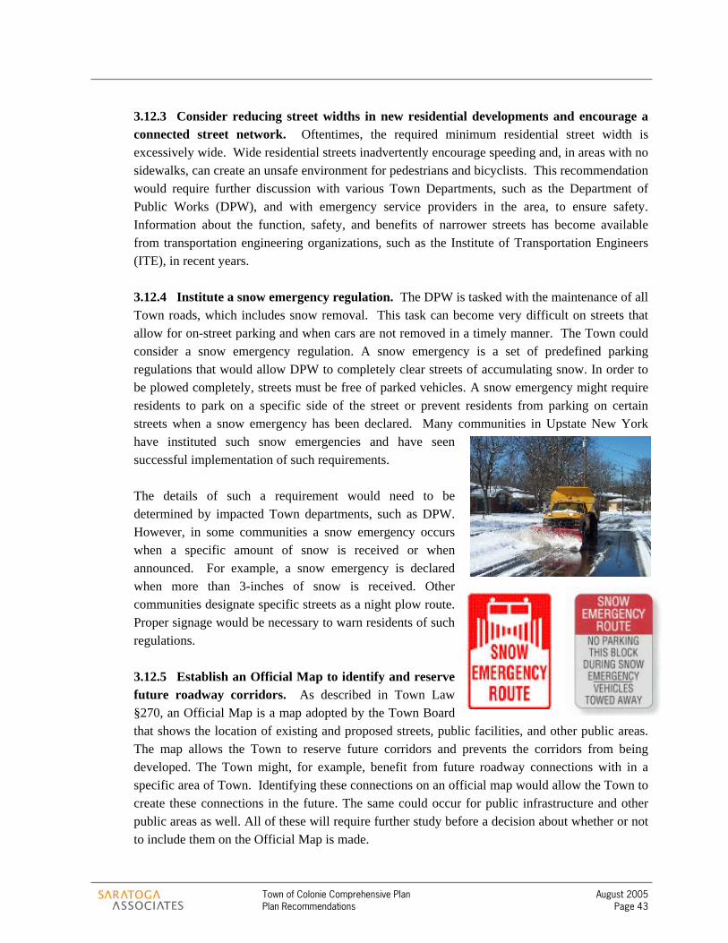
Town of Colonie Comprehensive Plan August 2005 Plan Recommendations Page 43
3.12.3 Consider reducing street widths in new residential developments and encourage a connected street network. Oftentimes, the required minimum residential street width is excessively wide. Wide residential streets inadvertently encourage speeding and, in areas with no sidewalks, can create an unsafe environment for pedestrians and bicyclists. This recommendation would require further discussion with various Town Departments, such as the Department of Public Works (DPW), and with emergency service providers in the area, to ensure safety. Information about the function, safety, and benefits of narrower streets has become available from transportation engineering organizations, such as the Institute of Transportation Engineers (ITE), in recent years.
3.12.4 Institute a snow emergency regulation. The DPW is tasked with the maintenance of all Town roads, which includes snow removal. This task can become very difficult on streets that allow for on-street parking and when cars are not removed in a timely manner. The Town could consider a snow emergency regulation. A snow emergency is a set of predefined parking regulations that would allow DPW to completely clear streets of accumulating snow. In order to be plowed completely, streets must be free of parked vehicles. A snow emergency might require residents to park on a specific side of the street or prevent residents from parking on certain streets when a snow emergency has been declared. Many communities in Upstate New York have instituted such snow emergencies and have seen successful implementation of such requirements.
The details of such a requirement would need to be determined by impacted Town departments, such as DPW. However, in some communities a snow emergency occurs when a specific amount of snow is received or when announced. For example, a snow emergency is declared when more than 3-inches of snow is received. Other communities designate specific streets as a night plow route. Proper signage would be necessary to warn residents of such regulations.
3.12.5 Establish an Official Map to identify and reserve future roadway corridors. As described in Town Law §270, an Official Map is a map adopted by the Town Board that shows the location of existing and proposed streets, public facilities, and other public areas. The map allows the Town to reserve future corridors and prevents the corridors from being developed. The Town might, for example, benefit from future roadway connections with in a specific area of Town. Identifying these connections on an official map would allow the Town to create these connections in the future. The same could occur for public infrastructure and other public areas as well. All of these will require further study before a decision about whether or not to include them on the Official Map is made.

Town of Colonie Comprehensive Plan August 2005 Plan Recommendations Page 44
3.12.6 Provide adequate bicycle facilities and establish a signed system of bicycle routes throughout the Town. Biking functions not only as a recreational activity, but also as an alternative mode of transportation. Over 50% of community survey respondents feel that bicycle lanes and corridors should be encouraged throughout the Town. The Town should provide facilities to ensure the safety and convenience of bicycling, such as the informational kiosk illustrated in the adjacent photo. The addition of bike lanes, proper pavement markings and signage, and a map of bike routes in the Town should be considered. The opportunity exists for the Town to enhance connections with regional bicycle routes, such as the Mohawk-Hudson Bike-Hike Path.
3.12.7 Consider opportunities to provide paved shoulders on all collector and arterial roads, where sidewalks are not provided. When sidewalks are not available, paved shoulders of sufficient width should be provided to allow for safe pedestrian and bicycle use. Paved shoulders should be provided on collectors and arterials regardless of jurisdiction – state, county or town. A minimum width of four (4) feet would be sufficient.
ECONOMIC DEVELOPMENT
3.12.8 Develop a Town-wide Economic Development Strategy. Given its prime location in the region and proximity to regional transportation systems, the Town of Colonie has not had the need to actively pursue economic development in the past. However, this is changing. As new, high technology markets emerge in the region, the competition to attract business and increase the local tax base becomes stronger. The Town should first identify the types of businesses it hopes to attract and then develop a strategy to attract those businesses. The Planning and Economic Development Department, the local Chambers of Commerce and the IDA could work together to develop incentives for business to locate in specified areas.
3.12.9 Revise zoning and development regulations to facilitate a more efficient development process. Streamlining the development process is critical to promoting economic development in the community. Developers and potential developers want to understand early in
Example of an informational kiosk along a bike path (left) and a clearly marked bike lane (right).
Town of Colonie Comprehensive Plan August 2005 Plan Recommendations Page 45
the development process what is expected of them and what they can expect in turn from the Town regarding standards and time schedules. The Town should also formally establish design guidelines for specific commercial areas of the Town. As discussed previously, design guidelines would address building placement, the location of parking, pedestrian facilities and other design and functional aspects.
In creating a predictable process, it is likely that a more expeditious development review process would result. Throughout the comprehensive planning process, developers have indicated frustration with the lengthy timeframe associated with development review in the Town. Any revisions that take place should carefully consider ways in which to improve this process. For instance, the Town should continue efforts to expedite the inter-departmental reviews. In addition, the Town should consider having the special use permit be part of the Planning Board review process. This would serve to expedite the special permit process.
3.12.10 Identify locations for infill development and redevelopment activities and encourage the use of such locations. There are locations in Colonie that would be appropriate for redevelopment or infill development. Infill development is the development or redevelopment of vacant or underutilized parcels located in otherwise built-up areas. The Planning and Economic Development Department could work with the Colonie Industrial Development Agency (IDA) to create an inventory of appropriate redevelopment locations and develop an incentive program to encourage the reuse or redevelopment of these areas. This could also be part of a larger, more comprehensive economic development strategy.
Initial locations for infill or redevelopment could be found along Railroad Avenue or Lincoln Avenue. These industrial areas, while still viable, are prime locations for redevelopment. In addition, there may be underutilized buildings in other areas of the community that represent opportunities for redevelopment. A detailed inventory would assist in finding other appropriate locations. The Town should encourage developers to utilize existing vacant and underutilized buildings and sites before building on greenfields. This practice will provide opportunities for additional development within the Town, while also maintaining the Town’s remaining open spaces. There are numerous ways in which the Town could encourage such activities including tax incentives, an expedited review process, or a reduction in application fees. Additional assistance might also be in the form of sharing the costs of improved infrastructure or forming creative partnerships to assist a developer or group of developers with these costs.
3.12.11 Coordinate with the Albany-Colonie Chamber of Commerce and the Latham Chamber of Commerce to promote local businesses and quality employment. Each Chamber seeks to encourage planned economic development that supports local commerce and quality of life. The Planning and Economic Development Department should also work with the Chambers to identify an economic vision for the community and work to integrate that vision into the region’s economic vision. In addition, these organizations could work to retain the Town’s younger population through the creation of quality employment.

Town of Colonie Comprehensive Plan August 2005 Plan Recommendations Page 46
STORMWATER MANAGEMENT 3.12.12 Comply with Phase II Stormwater Management Regulations. The U.S. Environmental Protection Agency (EPA), in an effort to protect and preserve the nation’s water resources, has developed a stormwater management rule. Phase II of the Stormwater Rule is currently underway and is intended to institute controls on unregulated sources of storm water discharges that may cause environmental degradation. Municipal Separate Storm Water Systems (MS4s) located in Urbanized Areas (as defined by the U.S. Census) are automatically covered by a nationwide permit under the Phase II rule. Phase II represents an expansion of requirements set forth in Phase I. The MS4s are required to develop and implement a stormwater management program by 2008.
The Town of Colonie, as an urbanized area, has recently completed a draft report addressing the management of stormwater. The report recommends a watershed approach to bring greater levels of awareness to stormwater management issues such as flooding, maintenance, future facilities, growth and inter-municipal coordination. Existing policies and documents that address stormwater management in the Town include the following:
> Town of Colonie Highway and Drainage Standards > Final Generic Environmental Impacts Statements for the Boght Road/Columbia Street,
Airport Area and the Lisha Kill/Kings Road area > Town of Colonie Watercourse Area Management Local Law > Grading Law
The report also suggest multiple recommendations that are watershed specific. Recommendations are provided for the Lisha Kill, Vly Creek, Shaker Creek, Delphus Kill, and tributaries to the Mohawk River, Cherry Creek, Sand Creek, Red Creek, Nucklos Creek, Cemetery Creek, Salt Kill, Kromma Kill, and Gas House Creek.
3.12.13 Anticipate and budget for the long-term maintenance of stormwater management facilities. Compliance with the Phase II Stormwater Regulations will likely lead to increased long-term maintenance costs that will be passed on to the Town. The Town should prepare to maintain the facilities that are created to address stormwater management and should prepare to address such costs through its annual budget.
INFRASTRUCTURE
3.12.14 Focus on maintaining existing infrastructure. As an older suburban community, the Town of Colonie has areas where existing water and sewer infrastructure is aging and in need of continued attention. In some locations, water and sewer pipes are over sixty years old and it is not unusual for water line breaks or other failures to occur. The Town of Colonie does have an ongoing maintenance program and a portion of its annual capital budget is devoted to infrastructure rehabilitation. However, identifying problems early and providing preventative maintenance is difficult to accomplish within current funding levels.

Town of Colonie Comprehensive Plan August 2005 Plan Recommendations Page 47
It is anticipated that infrastructure maintenance will be a growing issue for the Town in coming years, especially when addressing stormwater management under the Phase II Stormwater Management Regulations. As a result, the Town will need to review its Capital Plan to ensure that adequate levels of funding are available to meet this need. The Town currently addresses safety and security issues associated with existing public infrastructure on a regular basis. The Latham Water District, for example, complies with all state and federal regulations related to the safety and security of public infrastructure.
3.12.15 Coordinate infrastructure maintenance and improvement programs with planned development. The comprehensive plan has identified locations in the Town of Colonie where future development or redevelopment should be focused. The plan notes that the Town cannot spread outward, and should instead cultivate careful redevelopment of some of its older commercial sites as an alternative to continuing to develop primarily in new locations. Within these centers or nodes of development, the plan envisions development or redevelopment as compact, mixed-use centers of activity for the community. Though the scale of these centers or nodes would vary, they would typically be developed at somewhat higher densities than has been common in suburban commercial areas.
In order to accomplish this important goal of the comprehensive plan, the Town will need to coordinate its infrastructure maintenance and improvement priorities with development initiatives in these targeted areas of the community. Right-sizing infrastructure for future planned development will ensure that resources are used efficiently. For example, the comprehensive plan discusses the possibility of Wolf Road evolving into a more complete, mixed use Town Center for Colonie. As part of future master planning for a Wolf Road Town Center, the Town will need to address infrastructure needs. It is already known that a sewer pump station along Wolf Road is operating near capacity, and ideally improvements to the pump station could be designed in contemplation of additional development or redevelopment consistent with a master plan for the area. The timing suggested in this example may not be achievable (i.e. improvements to the pump station may be needed before a Wolf Road Town Center Master Plan could be completed given other priorities), however the recommendation to coordinate such investments with planned development areas remains valid.
3.12.16 Coordinate infrastructure maintenance and improvement programs with Economic Development initiatives. In a similar fashion to the recommendation above, the Town will need to coordinate its infrastructure maintenance and improvement program with specific initiatives outlined in an Economic Development Strategy developed as part of the implementation of this comprehensive plan (see Section 7.2, Short-term Actions). In order to stimulate economic investment in areas such as the Industrial Revitalization Areas, infrastructure needs should be calibrated with targeted industries identified for each of these locations. For example, if the Economic Development Strategy finds that the Railroad Avenue area is suitable for technology related industries tied to the region’s Tech Valley Initiative, specific infrastructure needs should

Town of Colonie Comprehensive Plan August 2005 Plan Recommendations Page 48
be addressed up front to make this corridor “shovel ready” for this type of development. Consistent water and electric supplies, and high-speed communications infrastructure might be needed investments in this case.
Except where public health and safety are at issue, restrict or give low priority to water and sewer infrastructure investments in areas that are designated in this document as conservation areas. The previous three recommendations suggest priority areas for infrastructure investment – maintenance of existing infrastructure; areas targeted for focused, mixed-use development; and areas targeted for economic development initiatives. This recommendation suggests the opposite - areas that are not targeted for growth, or which are desired for conservation purposes, should have a low priority for infrastructure investment. If water and sewer infrastructure is still needed, to support homes in new conservation subdivisions for example, the pipes should be sized to reflect the limited density of future development in these areas.
While there are only about thirty pockets in the Town that are not already served by public sewer, and only about a third of the Town is not served by public water, the Town can still use infrastructure investments, or more precisely the lack thereof, to help control its growth. For example, the Kings Road area is not currently served by public sewer. Providing sewer service in that area would be expensive due the need for several pump stations. However, because the area is located within the Albany Pine Bush Preserve, it is not targeted for significant development, and therefore investing in urbanizing infrastructure such as public sewers is probably not necessary there. In fact, providing such infrastructure in the area would increase the development potential, and therefore the value, of these lands in direct conflict with the desire to conserve much of this area.
3.12.17 Consider modern infrastructure needs. Investigate the current condition of, and improve as necessary, the technology infrastructure available in Colonie. In previous decades, transportation, electricity, and water and sewer infrastructures were considered necessary ingredients for economic development. Creating “shovel-ready” sites for economic development therefore focused on ensuring that these areas were equipped with such infrastructure in advance of actual proposals. Today, in addition to these other forms of infrastructure, the availability of technology infrastructure (for high speed communication) is essential for the many technology based or technology dependent industries. Many of these businesses could be appropriately located in areas of the Town.
As improvements are made to specific areas targeted for development, such as the Industrial Revitalization Areas, the Mixed Use and Office Mixed Use Areas, and the Airport Business Area, technology infrastructure should be provided. Niagara Mohawk’s Wired Building Grant Program and similar initiatives through New York State and the federal Government should be pursued.
3.12.18 Expand educational efforts related to water conservation. Some of the growth in demand for public water in recent years is not attributable to population growth. Instead, it

Town of Colonie Comprehensive Plan August 2005 Plan Recommendations Page 49
appears that water usage is increasing rapidly due, in part, to residents’ desires for a green lawn. It is estimated that lawn irrigation doubles water usage for the average home in Colonie. Though water capacity is not currently an issue for the Town, it might still make sense to promote the wise use of the Town’s water resources. Educational programs describing the benefits and methods of water conservation could be easily developed and implemented throughout the Town.
HISTORIC AND CULTURAL RESOURCES The Town of Colonie has a great heritage and it is important that this heritage be preserved and celebrated. The Loudon Road Historic District is one example of a recognized historically significant area. The Loudon Road Historic District was placed on the National Register of Historic Places in 1979. The district boundary includes Loudon Road from Cromitie Road to Menands Road in Loudonville. Approximately 360 acres and 20 buildings make up this district that is recognized for its historical significance in architecture and engineering. The Watervliet Shaker Historic District is also listed on the National Register of Historic Places and includes the area surrounding Albany Shaker Road, southwest of Albany International Airport (including Ann Lee Pond and Stump Pond). This district was added to the National Register in 1973 and is the site of the first Shaker settlement called Wisdom Valley. Wisdom Valley was founded by Mother Ann Lee in 1776 and is one of only seven community sites that have museums or restored structures exemplifying the Shaker way of life. The Old Shaker Cemetery, apple orchard, millpond, and three Shaker ‘family’ home sites are also located within the district. In addition, a portion of the Watervliet Shaker Historic District is located within the Albany County Nature and Historic Preserve. This preserve was created by the county legislature in 1976 to preserve areas of the county identified as environmental and historically sensitive. The Ann Lee Pond, for example, is included in the county-designated Nature and Historic Preserve.
3.12.19 Compile and organize existing historic and cultural resource information to develop a comprehensive Town-wide inventory. There are numerous sites and buildings of historic or cultural importance within the community. Nearly 87% of those responding to the community survey feel it is important or very important to preserve historic sites and structures. Overwhelmingly, the Shaker sites are believed to be special sites in the Town that need protection, according to the survey. The Town Planning and Economic Development Department and the Town Historian, in coordination with the Shaker Heritage Society and local volunteer groups, could work to pull this information together in a timely manner.
While many of these resources are already documented (i.e. the National Register of Historic Places), it would be helpful to have this information in one easy-to-find location. An inventory could be the first step in properly identifying these resources and developing options for stewardship and preservation. Such an activity could also be the starting point for developing programs to promote and educate the community about these important resources. As part of the inventory, perhaps a brochure could be created that identifies the locations of these resources and

Town of Colonie Comprehensive Plan August 2005 Plan Recommendations Page 50
allows residents and visitors to embark on a self-guided walking tour. Various entities could assist the Town in this endeavor, in addition to volunteer organizations. The New York State Office of Parks, Recreation, and Historic Preservation, for example, could provide valuable technical and perhaps financial assistance for programming and preservation. In addition, other areas throughout the Town could be considered for historic district designation.
3.12.20 Consider architectural standards within State and National Register Historic Districts. The Loudon Road Historic District and the Watervliet Shaker Historic District are home to several significant structures, each with their own architectural style. Maintaining the character and integrity of these district requires a more careful look at new development and significant alterations to existing structures. The Town could consider developing architectural standards that could be reviewed by a board, such as an Architectural Review Board. Architectural standards would provide such a board with the tools it needs to encourage developers and property owners to address architectural design issues. A more detailed conversation should occur with property owners within the Historic District to better understand their needs and to determine what is appropriate.
A second related step the Town could consider is to participate in the Certified Local Government (CLG) program. The CLG program is a nationwide program resulting from the National Historic Preservation Act. The CLG program establishes a formalized link between a local community’s commitment to the preservation of historic resources and state and federal historic preservation programs. In becoming a CLG, a community enhances its capacity to make decisions regarding local historic preservation and planning issues by tapping into technical, legal and financial assistance offered through the New York State Historic Preservation Office (SHPO). To become a CLG, a local government must be approved and certified by the National Park Service, enact a local preservation law meeting specified standards, establish a process to landmark historic resources, and create a local Historic Preservation Commission. SHPO officials could assist the Town in taking the necessary actions to become a CLG.
3.12.21 Raise awareness of the William K. Sanford Town Library. The William K. Sanford Town Library located at 629 Albany-Shaker Road is an important resource in the Town. The library provides over 173,000 books and reference materials including periodicals, audiovisual materials, children’s books, adult reference titles and large print books. The library also provides adult programs such as business finance, Internet workshops, and English as a Second Language classes. The Youth Service Department offers storytime for preschoolers, craft programs, a summer reading club and other events.
The Library of Congress
Town of Colonie Comprehensive Plan August 2005 Plan Recommendations Page 51
The Town, in coordination with library staff and volunteers, could raise public awareness of the programs and services the library has to offer through increased public relations and outreach efforts. The concepts of a bookmobile or a satellite library location to serve residents throughout the Town might also prove to be successful outreach activities. In addition, the Library of Congress and the American Library Association are resources that local libraries can utilize to assist in increasing recognition of the importance of the Town Library. These organizations have created, for example, a Tip Sheet and Toolkit that provide interesting ways to engage the community.

Section 4 – Plan Recommendations Map
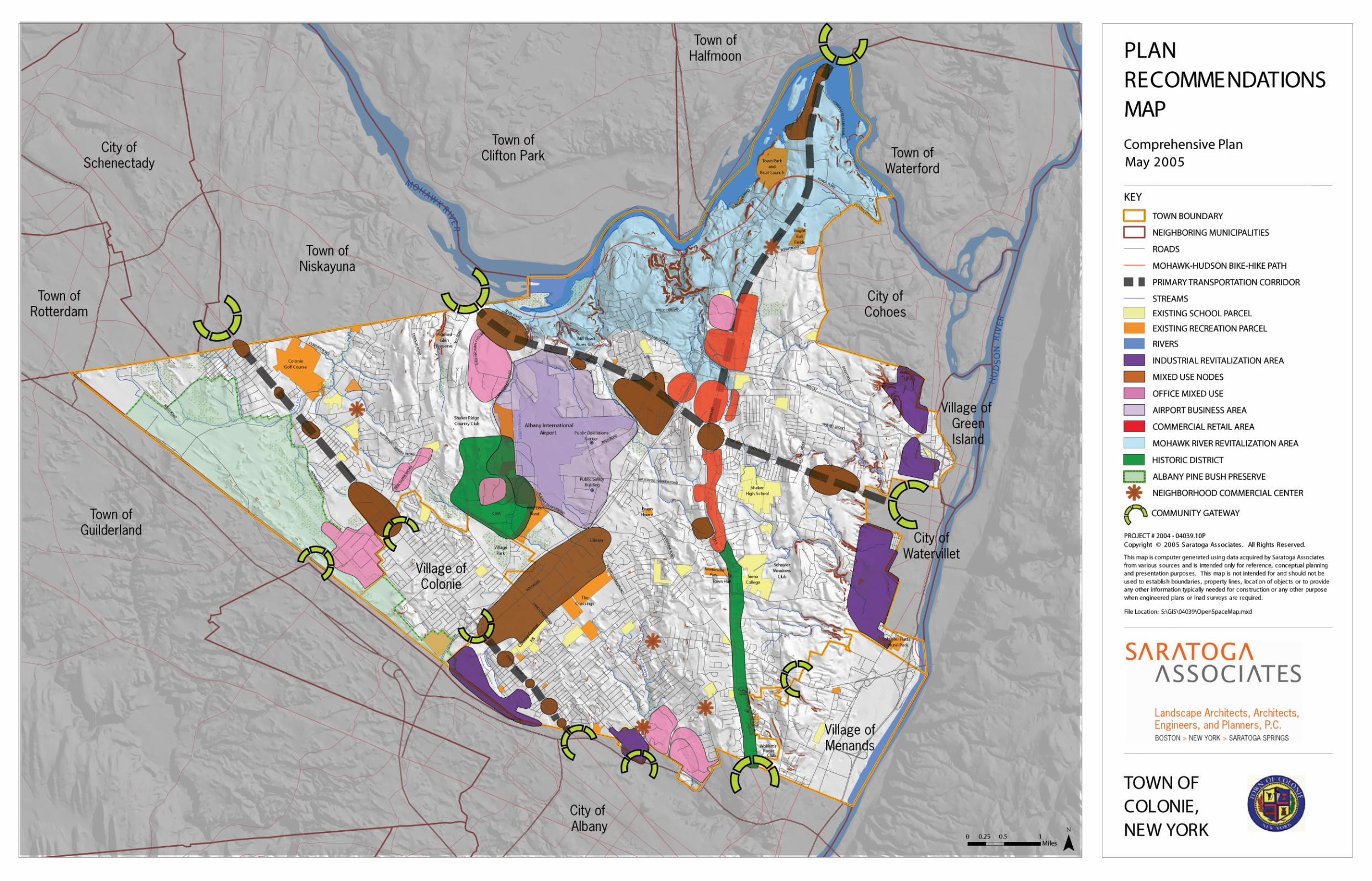

Section 5 – Town-wide Open Space and Recreation Plan

Town of Colonie Comprehensive Plan August 2005 Open Space and Recreation Plan Page 52
Section 5 5.1 OVERVIEW OF THE OPEN SPACE AND RECREATION PLAN The Town of Colonie recognizes the importance of preserving open spaces and enhancing recreational opportunities for its residents. Of those responding to the community survey, 57% consider preserving open spaces a high priority, 56% believe protecting scenic views is very important and 54% feel protecting wildlife is very important. In response to these survey results and discussions that have taken place during focus group meetings throughout the comprehensive planning process, several comprehensive plan goals listed in Section 1 relate to the conservation of farmland and open space or the development of a network of open lands.
The benefits of protecting open space and enhancing recreation resources are many. There are social benefits that provide both formal and informal public gathering places, such as the Town Park or The Crossings. There are health benefits in the form of designated locations for physical activity including the Mohawk Hudson Bike Hike Path and the Boght Ballfields. There are environmental benefits through the protection of important natural systems and wildlife habitats, such as the Pine Bush and the many watercourses found throughout the Town. Lastly, there are fiscal benefits associated with the protection of open space as well. Numerous ‘cost of community services’ studies demonstrate that open space generates a net fiscal benefit to local governments. This fiscal benefit is the result of open space generating more in property tax revenue than it requires in public services. In comparison, residential development often generates a net fiscal loss because the costs for public services, such as schools, roads, sewer, water and police are more than the residential development generates in tax revenue.
Goal: Encourage the conservation of viable farmland and significant open spaces.
Goal: Develop a network of open lands to provide wildlife habitat and potential recreational trail corridors.
Goal: Protect the Town’s important natural resources such as stream corridors, steep slopes, floodplains, wetland systems, and unique ecosystems.
Goal: Enhance the Town’s Mohawk River waterfront.
Goal: Expand active and passive recreational resources available in the Town to meet the growing and changing demand for these amenities.

Town of Colonie Comprehensive Plan August 2005 Open Space and Recreation Plan Page 53
To achieve the community’s open space and recreation goals and to enjoy the benefits of protecting open space, the Town has decided to devote an entire section of the comprehensive plan to discussing open space and recreation resources. The resulting Open Space and Recreation Plan is a combination of the Open Space and Recreation Map and supporting text. The following section illustrates and describes existing open space and recreation resources, identifies future opportunities for protecting these resources and provides for recommended actions and strategies. The Open Space and Recreation Map found in Section 6 illustrates the community’s open space vision in an easy to understand format. This map is a useful tool that can assist Town staff, the Planning Board, developers and the public to guide growth in a manner consistent with the comprehensive plan goals. This tool illustrates natural features, open spaces and recreation resources located in the Town and provides improved knowledge about a site that may be developed such as:
> What are the open space resources on a particular site? > Where are these resources located? > How do these resources relate to the community’s open space vision?
Existing trails, potential trails, areas of high conservation interest, and areas for conservation or conservation design are also identified on the map. The map shows the location of these resources, how these elements relate to one another, and how these resources relate to the developed areas of the Town as a network of open spaces and recreation resources.
5.2 EXISTING OPEN SPACE AND RECREATION RESOURCES
5.2.1 Geology. The Town of Colonie encompasses 57.9 square miles in Albany County, situated north of the City of Albany and Town of Guilderland, west of the Hudson River and City of Watervliet, south of the Mohawk River and east of the Town of Niskayuna.
Ten to fifteen thousand years ago, when the glaciers covering North America receded, a large glacial lake, Lake Albany, formed in the Capital District. As that lake drained, much of Colonie was left a moderately level area. The small drainage rill eventually became Colonie’s larger creeks: Patroon’s Creek, Sand Creek, Lisha Kill, Shaker Creek, Delphus Kill and the Salt Kill. Along the Hudson and Mohawk Rivers are long alluvial flats, that provided extremely fertile soils for agriculture, as a result of the continual flooding.
As Colonie is bordered on the north by the Mohawk River, and to the east, by the Hudson River, there are significant steep slopes on the crests of those two river valleys, that also provide beautiful views of both the river and the Taconic Ridgeway to the East. The Shaker Ridge area, in the northwest, and the lands to the east of the Northway are generally gently rolling hills. Very flat areas can be found in and around Albany International Airport, and along the Route 5 – Central Avenue Corridor.

Town of Colonie Comprehensive Plan August 2005 Open Space and Recreation Plan Page 54
5.2.2 Watercourses. Approximately 91 miles of watercourses are protected in the Town of Colonie under the Town’s stream corridor protection overlay that was enacted in 1989. Included for protection are the Mohawk River, major tributaries of the Mohawk and Hudson Rivers, such as the Delphus Kill, Lisha Kill, Salt Kill, Sand Creek and Shaker’s Creek, among many others. Currently, any disruption or work within the 100’ of the watercourse’s banks must be approved by the Significant Environmental Areas Management Board. Approximately, 1,921 acres of the Town are located within the protected watercourse buffer.
5.2.3 Wetlands and Floodplains. There are 1,531 acres of New York State DEC Wetlands in the Town of Colonie. NYSDEC wetlands must be 12.4 or more contiguous acres. Additionally, land within 100’ of each NYSDEC wetlands is protected by the State. Wetlands are determined by not only the presence of standing water, but by certain vegetation that thrive in wet soils, that indicate the presence of moisture over a period of time. The U.S. Army Corp of Engineers protects “all waters of the U.S.,” including wetlands. Unlike State wetlands, federal wetlands are not mapped. Federal wetlands are typically identified through a detailed wetland delineation on a site by site basis. Wetlands are regulated by the Corps with the exception of isolated wetlands (wetlands not directly connected to streams or other water bodies associated with navigable waters). The Corps still considers these “isolated” wetlands as aquatic resources.
As a part of the 1972 Clean Water Act, the federal government decided to protect wetlands for several reasons. Wetlands provide many benefits to communities, including flood and storm water control, surface and groundwater protection, erosion control, treatment of pollution and habitat for fish and wildlife.
A floodplain is the level land along the course of a water body. To mitigate the effects if a flood during time of high water levels (after a large rain or snowmelt), the Federal Emergency Management Agency has identified and mapped the 100-year floodplain of many streams and rivers as part of the Flood Insurance Rate program. These are referred to as the Flood Insurance Rate Maps (FIRM) and are used by lending institutions to determine properties that are at risk of flood damage and require flood insurance. In Colonie, these floodplain areas are located in and around the Mohawk River, the Hudson River, the Lisha Kill, Shaker Creek, the Delphus Kill, Sand Creek and the Salt Kill.
5.2.4 Albany Pine Bush Preserve. A large portion of the southwestern border of Colonie, along the Guilderland town line, are land in the Albany Pine Bush. After glacial Lake Albany drained, dunes were formed by wind whipped sand, which were then stabilized by the globally unique plants of the Pine Bush such as the Pitch Pine, Scrub Oak and Smooth Shadbush. The

Town of Colonie Comprehensive Plan August 2005 Open Space and Recreation Plan Page 55
Karner Blue Butterfly, a federally endangered species, along with two rare natural communities and fourteen rare insects are native to the Pine Bush.
The Albany Pine Bush Preserve Commission was established in 1988 by the New York State Legislature. Recognizing the Pine Bush as a “rare and endangered natural community,” the Commission was charged to “protect and manage the Albany Pine Bush.” The Commission is a coalition of pubic and private entities, of which the Town of Colonie is a partner, along with the NYSDEC, the NYS Office of Parks Recreation and Historic Preservation, The Nature Conservancy, the City of Albany, the Town of Guilderland, Albany County, and four citizen representatives. Currently, 700 acres of protected Albany Pine Bush Preserve lands are within the Town of Colonie and located primarily in the area outlined on the Plan Recommendations Map. These protected lands are part of a 3,000-acre recreational resource that is open to the public. Within the Preserve, there are 18 miles of recreational trails allowing for a variety of non-motorized uses. These trails create connections to adjacent neighborhoods and municipalities. The Preserve also offers educational opportunities including self-guided exploration and interpretative programs. In addition, an environmental education facility is slated to open soon.
5.2.5 Mohawk River. There are approximately 10 miles of Mohawk River waterfront in the Town of Colonie. Recognized as an important, but underutilized asset to the Town, a grant was received for Colonie to participate in The Countryside Exchange Program in 2002. In 2003, the Town was visited by an international team of Waterfront experts to help the Town chart a course in the planning of this critical area. As a result of the exchange team’s recommendations, the Mohawk River Community Partners of Colonie, Inc. was organized “to identify, preserve, protect and promote the natural, scenic, cultural, historical, economic and recreational resources” of the waterfront area. Not only is the Mohawk River an important asset due to its beautiful scenic views, and adjacent bike/hike trails, it is also one of the main sources of the Town’s water supply.
5.2.6 Hudson River. A segment of the Town of Colonie’s eastern edge is located along the Hudson River and within the Hudson River Estuary. The Hudson River is one of fourteen designated American Heritage Rivers. The Hudson River is a unique waterbody in that is it a freshwater river experiencing tidal flows. The tidal activity create an estuary habitat for many aquatic creatures.
5.2.7 Parks and Recreation Resources. The Town of Colonie has an extensive park system and recreation facilities providing a range of active and passive recreation opportunities. The Town of Colonie Parks and Recreation Department maintains approximately 850 acres of parks
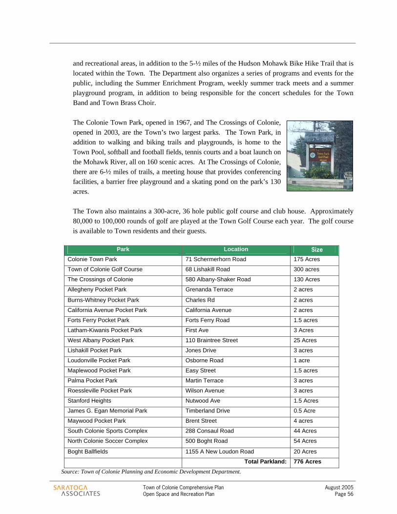
Town of Colonie Comprehensive Plan August 2005 Open Space and Recreation Plan Page 56
and recreational areas, in addition to the 5-½ miles of the Hudson Mohawk Bike Hike Trail that is located within the Town. The Department also organizes a series of programs and events for the public, including the Summer Enrichment Program, weekly summer track meets and a summer playground program, in addition to being responsible for the concert schedules for the Town Band and Town Brass Choir.
The Colonie Town Park, opened in 1967, and The Crossings of Colonie, opened in 2003, are the Town’s two largest parks. The Town Park, in addition to walking and biking trails and playgrounds, is home to the Town Pool, softball and football fields, tennis courts and a boat launch on the Mohawk River, all on 160 scenic acres. At The Crossings of Colonie, there are 6-½ miles of trails, a meeting house that provides conferencing facilities, a barrier free playground and a skating pond on the park’s 130 acres.
The Town also maintains a 300-acre, 36 hole public golf course and club house. Approximately 80,000 to 100,000 rounds of golf are played at the Town Golf Course each year. The golf course is available to Town residents and their guests.
Park Location Size
Colonie Town Park 71 Schermerhorn Road 175 Acres
Town of Colonie Golf Course 68 Lishakill Road 300 acres
The Crossings of Colonie 580 Albany-Shaker Road 130 Acres
Allegheny Pocket Park Grenanda Terrace 2 acres
Burns-Whitney Pocket Park Charles Rd 2 acres
California Avenue Pocket Park California Avenue 2 acres
Forts Ferry Pocket Park Forts Ferry Road 1.5 acres
Latham-Kiwanis Pocket Park First Ave 3 Acres
West Albany Pocket Park 110 Braintree Street 25 Acres
Lishakill Pocket Park Jones Drive 3 acres
Loudonville Pocket Park Osborne Road 1 acre
Maplewood Pocket Park Easy Street 1.5 acres
Palma Pocket Park Martin Terrace 3 acres
Roessleville Pocket Park Wilson Avenue 3 acres
Stanford Heights Nutwood Ave 1.5 Acres
James G. Egan Memorial Park Timberland Drive 0.5 Acre
Maywood Pocket Park Brent Street 4 acres
South Colonie Sports Complex 288 Consaul Road 44 Acres
North Colonie Soccer Complex 500 Boght Road 54 Acres
Boght Ballfields 1155 A New Loudon Road 20 Acres
Total Parkland: 776 Acres Source: Town of Colonie Planning and Economic Development Department.

Town of Colonie Comprehensive Plan August 2005 Open Space and Recreation Plan Page 57
Fifteen “pocket parks” dispersed throughout the Town provide playground facilities as well as tennis and basketball courts. The West Albany Memorial Park, at 22 acres, is the largest pocket park, and has 8 baseball and softball fields. Additionally the Town has three ball field complexes, with soccer, baseball, softball and tee ball fields.
5.2.8 The Mohawk Hudson Bike Hike Trail. The Bike Hike Trail is a 35-mile long multi-use trail that runs through Schenectady and Albany Counties, and is a part of the 350-mile statewide “Canalway Trail” that extends from Buffalo to Albany. In 2003, the Capital District Transportation Committee developed a plan to fill in the gaps that are located throughout the trail. Priority areas for trail connections in Colonie include connecting Broadway in Colonie/Menands with the trail, the newly realigned Albany Shaker Road with the trail and a trail extension to Peebles Island. The Hudson Valley Greenway has ultimate plans to connect the Mohawk Hudson Bike Hike Trail down the Hudson River to New York City.
Between the Village of Menands, and the City of Watervliet, yet still in the Town of Colonie, is The Schuyler Flatts Cultural Park, a site that is steeped in significance to both Native and Colonial American history. This 43-acre site serves as an educational resource to residents and visitors, as well as a passive recreation area, with its wide, open fields.
5.3 OPPORTUNITIES FOR OPEN SPACE AND RECREATION While much of the Town of Colonie has been developed, several opportunities still exist to protect open space and enhance recreation resources.
5.3.1 Recreation Resources. The Town should consider expanding and improving the existing parks and trail system. As described above, the Town has many parks and an extensive bike- hike trail already established. There are opportunities to improve and expand these facilities, where appropriate and to create a network of recreation resources. The Town might consider the creation of an environmental education center associated with the Mohawk Hudson Bike Hike Trail and the Mohawk River, for example. School children, residents and visitors could learn of the history of the area, as well as discussing important environmental features along the Mohawk River. The Town’s old water treatment facility might be one possible location for such a center.
Town of Colonie Comprehensive Plan August 2005 Open Space and Recreation Plan Page 58
5.3.2 Potential recreational trails. The Open Space and Recreation Map shows many potential trails that would be appropriate in creating a network of connected trials and bicycle routes throughout Colonie and the region. Existing biking and hiking facilities include the Mohawk Hudson Bike Hike Path, a variety of bicycle routes, such at the Route 9 Bicycle Route, and trails through the Town Park and The Crossings. These trails include a combination of on road or off road facilities.
Many opportunities exist to increase the number of trails and bicycle routes in the Town and create connections between neighborhoods and the Town’s recreation facilities or connections to the Mohawk River and the Mohawk Hudson Bike-Hike Trail. Opportunities for trail links exist in the vicinity of the new trail near Albany Shaker Road (behind the Hilton Garden Inn) and along British American Boulevard. Connections could also be made between neighborhoods and neighborhood services, which would encourage residents to use alternative modes of transportation. Some of the newly identified bicycle routes share existing roadways, while some of the potential trails are multi-use trails, off-road trails or hiking trails along protected waterways. One significant connection the Town could consider is completion of a bike path from the Ann Lee Pond area to the Bike Hike Trail.
Bicyclists currently use several roadways throughout the community as ‘unofficial’ shared roadway bicycle routes. However, limited signage exists to guide cyclists or to warn motorists of a shared roadway. To avoid potentially dangerous conflicts and to indicate directions, distances or destinations to cyclists, the American Association of State Highway and Transportation Officials (AASHTO) Guide for the Development of Bicycle Facilities recommends proper signage be placed in ¼ mile (500m) intervals and at all directional changes along the routes. Signed routes could also be mapped and coordinated with regional tourism activities.
The Town of Colonie Highway Department could coordinate this initiative to sign and maintain routes. In addition, the Town Highway Department could maintain the roadway shoulders to provide a safer place for bicyclists to ride. Grants and technical assistance may be available for signage through Transportation Enhancements Funding or the Capital District Transportation Committee (CDTC). Specific trail locations are identified on the Open Space and Recreation Map.
5.3.3 Scenic roads. There may be opportunities throughout the Town to recognize and preserve the unique character of scenic roads. The Town could encourage the use of the conservation subdivision process in areas where development is inevitable to preserve frontage and other distinguishing characteristics of scenic roads. Roadways with scenic qualities include roads such as River Road, along the Mohawk River and Kings Road in the Pine Bush area. Another roadway with scenic qualities is Route 9 from Fonda Road north to the Mohawk River.
5.3.4 Conservation areas and areas for conservation design. As illustrated on the Open Space and Recreation Map, several areas have been identified as areas where conservation is
Town of Colonie Comprehensive Plan August 2005 Open Space and Recreation Plan Page 59
appropriate and the use of conservation design should be considered for all development that occurs in these areas. These areas represent relatively large tracts of undeveloped land that is either in the path of development or could support additional development. Recognized as the few remaining areas of open space in the Town, the intent is to preserve the character of these areas as open spaces, while allowing for development to occur. A variety of tools are available to conserve these areas and are described in the recommended actions discussion below. The use of conservation subdivision design or land acquisition are examples of such tools that are useful in creating a network of open spaces. Areas of conservation interest include:
> Albany Pine Bush Preserve – This area is a critical habitat for the Karner Blue Butterfly.
This is a location where acquisition by the Town or a local land conservancy would be appropriate. The Town could work closely with the Pine Bush Commission to identify critical parcels for development.
> Ashford Glen Preserve – The Ashford Glen Preserve is already a preserved area and the
opportunity exists to expand the open space resources here through creative design of development and conservation easements.
> Ann Lee Pond Area – The Ann Lee Pond is a significant natural resource in the community.
Albany County is currently responsible for the Ann Lee Pond. Perhaps the Town could coordinate with the County to improve access to Ann Lee Pond and improve the hiking and biking amenities there as well. This area is also adjacent to a park in the Village of Colonie and expanding the protected open space in this area would assist in creating a more regional open space and recreation network.
> Area north of Albany International Airport (between Route 7 and River Road) – The airport,
as part of its acquisition program, has already acquired several parcels in this area. The Town should encourage this program and assist when necessary.
> Mohawk River Revitalization Area – There are specific locations within this study area that
might be considered for the purposes of preservation. Protection of viewsheds and land stewardship should be promoted, as well as traditional uses of the land including hunting and fishing. If development occurs within this area, the use of a conservation design approach should be encouraged.
> Delphus Kill Area – Within this area are specific parcels that would be appropriate for
preservation, such as the Kettle Hole Bog. The emphasis should be on maintaining open space. However, when development does occur in this area, it should be in the form of conservation design.
> Fonda Road Area - When development occurs in this area, the use of conservation
subdivision design should be required.

Town of Colonie Comprehensive Plan August 2005 Open Space and Recreation Plan Page 60
> Area south of the Boght Ball Fields and east of Route 9. When development occurs in this
area, the use of conservation subdivision design should be required.
> Area north of Route 7 near the boundary with the City of Cohoes - When development occurs in this area, the use of conservation subdivision design should be required.
> Area south of Route 7 in the vicinity of Haswell Road - When development occurs in this
area, the use of conservation subdivision design should be required.
> Area between Troy-Schenectady Road (Route 2) and Route 155 near the boundary with the City of Watervliet - When development occurs in this area, the use of conservation subdivision design should be required.
5.3.5 Parcels of high conservation interest. These are specific locations identified on the Open Space and Recreation Map that have significance in terms of a cultural, historical or open space resource. The Town should consider the protection of these areas as a priority. In some instances, such as the kettle bog or Stump Pond, preservation might be appropriate. In other cases, partnerships and coordination of conservation goals will be necessary, such as with the Ann Lee Pond, which is owned by Albany County and the Mohawk River Islands, which are owned by the Canal Corporation. Six locations are shown on the map including:
> Ann Lee Pond / Shaker Heritage Site > Stump Pond > Parcels adjacent to The Crossings > Pruyn House > Kettle Bog > Islands on the Mohawk River
In addition, the Town as a member of the Albany Pine Bush Commission, voted in support of the 2002 Management Plan. Parcels identified for full protection within the Management Plan should be considered areas of high conservation interest as well.
5.4 RECOMMENDED ACTIONS AND STRATEGIES FOR OPEN SPACE AND RECREATION
Identifying opportunities for open space protection and additional recreational resources is a critical first step. In order to successfully protect these resources, a series of actions and strategies will need to be implemented. In most instances, the solution to open space protection will not be a single action, but rather a combination of several actions. The following recommended actions and strategies are each proven techniques for protecting and preserving open space and recreation. Communities across New York State and the nation are utilizing these strategies to preserve open
Town of Colonie Comprehensive Plan August 2005 Open Space and Recreation Plan Page 61
spaces and enhance recreation activity. The Town could choose to implement one or many of these techniques, depending on the unique situation of each opportunity that may arise. Implementation of these actions and strategies may fall to any number of volunteer groups, appointed groups such as the Conservation Advisory Council or Town Departments, such as the Department of Parks and Recreation or the Planning and Economic Development Department. Perhaps the role of the existing Conservation Advisory Council could be expanded, at the Town Board’s discretion, to begin work on the various initiatives described. Also, organizations such as the Albany County Land Conservancy (ACLC) are often willing to work with communities to achieve meaningful open space protection. Within the discussion of each recommended action or strategy, the most appropriate group to implement the action will be identified. In addition, possible technical and financial resources will also be specified, where appropriate.
Acquisition of open space is one method of preserving open space. This is a voluntary method involving only willing landowners.
Fee simple acquisition, purchase of development rights (PDR), conservation easements, and transfer of development rights (TDR) are all methods to acquire open space. Acquisition may be in the form of a donation or purchase. Parties responsible for such acquisition may include the Town, a local land conservancy such as the Albany County Land Conservancy or the Pine Bush Commission through the Nature Conservancy. Fee Simple Acquisition is the outright acquisition of land, including all rights associated with land ownership. It is the most common type of real estate transfer. Purchase of Development Rights, or PDR, occurs when the development rights associated with a particular property are sold to a land trust or government agency. The right to develop property is one of several rights that are attached to land ownership. Development rights may be sold or donated separately from all other rights associated with the land. The property continues to remain under private ownership, even after the development rights have been removed. Typically, the uses associated with that land is limited to farming or open space after development rights have been removed. PDR is a voluntary action. Conservation Easements are legal documents restricting the use of property to open space, wildlife habitat or agriculture. Every conservation easement is different and the arrangement is made specific to the particular property under easement. A landowner may sell or donate an easement to a land trust, such as the Albany County Land Conservancy, or a government entity. The donation of a conservation easement provides benefits to the landowner as well as the community. A donation may alleviate estate tax and income tax burdens for landowners.
5.4.1 Consider acquisition of open space from willing sellers or donors.

Town of Colonie Comprehensive Plan August 2005 Open Space and Recreation Plan Page 62
The Transfer of Development Rights, or TDR, occurs when development rights are not used on the land from which they come, but instead are transferred to a designated site called a receiving area. Once a TDR occurs, the land from which the development rights came (sending area) is then restricted as open space or agricultural land. This technique has worked well in some areas of the country, but requires significant staffing resources to make it successful. In addition, it is critical to establish sending and receiving areas consistent with the open space vision in advance of development occurring. This might also be achieved through with an incentive zoning approach, as described below. Some locations where acquisition might be appropriate include the following:
> The Kettle Bog > Critical areas of the Pine Bush as identified in the 2002 Management Plan > The Ann Lee Pond and Shaker Heritage Site area > Areas providing potential public access to the Mohawk River, such as the property located
between the Town water treatment facility and the Mohawk View Water Pollution Control Plant.
> Parcels of high conservation interest.
Incentive zoning is a technique used in many communities. In return for providing a public benefit, such as preserving open
space or providing a recreational trail, a developer may receive a bonus. A bonus could be in the form of an additional floor of commercial development or increased density in the case of residential development. Again, this is a voluntary measure. If a developer does not wish to provide a public amenity, they are not required to do so. However, the developer will then not be eligible for the bonus. Incentive Zoning could be used to provide public access to protected open space for the development of pedestrian or recreational pathways. It is important to recognize that there is no automatic right for the public to have access to open lands created from conservation subdivisions. The Town cannot compel a private landowner to allow public access on their land. However, the Town can purchase the right for public access and/or offer incentives to the landowner for allowing public access through open lands. Incentives for public access can be built-in to the revised land use regulations as an incentive zoning provision. In this case, the developer of a conservation subdivision would be offered some modest increase in the allowed density, perhaps up to 10% or 15% of the total number of permitted housing units, in return for permitting public access to the open lands. Although NYS General Obligations Law has become much more supportive in terms of limiting the liability of landowners who allow public access to their lands for the purposes of enhancing recreational opportunity, the Town should
5.4.2 Encourage the use of Incentive Zoning
Town of Colonie Comprehensive Plan August 2005 Open Space and Recreation Plan Page 63
consider if it can extend its own existing liability coverage to any trails created as part of this network. These types of incentives can be very powerful tools for establishing a community trail network.
It is recommended that the Town revise its zoning regulations to require the use of conservation subdivision
design in conservation areas as illustrated on the Open Space and Recreation Map. Conservation subdivision design is a form of cluster development that takes into consideration the natural features of a landscape. Utilizing conservation subdivision will allow development to occur and still provide opportunities to conserve open spaces and trails. This form of development will permit flexible lot-sizes, facilitating creative design in harmony with the landscape. In addition to the environment and scenic benefits of allowing homes to be sited in a creative way, a network of conserved open lands can be created in the process. The Conservation Subdivision Design approach begins with the identification of open space resources present on the site to be developed (environmentally constrained land, agricultural land, historic or scenic views, significant woodlots, etcetera). This first step is what distinguishes the conservation subdivision approach from the more traditional clustering approach. A Town-wide map of open space resources can be a useful guide for starting this identification process and is found in Section 6. This resource identification will form the basis for designating conservation lands in the new subdivision. Once conservation lands are identified and designated, areas where development would be most appropriate are identified. Homes (the number based on allowable density for the zoning district) are then designed into the development areas of the site in a creative fashion. Flexible lot sizes and area and bulk standards facilitate this creativity. Identifying road alignments and lot lines are the final steps in the Conservation Subdivision Design process.
5.4.3 Require the use of Conservation Subdivision Design as development occurs.
Conservation Subdivision Design (term coined by Randall Arendt) Uses open space resources present on a site to be developed as the starting point for design (In the same way that a golf-
course community is designed). The four-step conservation subdivision design process is quite simple:
1. Identify conservation areas – potential development areas follow once the conservation areas have been “greenlined”. 2. Locate house sites 3. Align streets and trails 4. Draw in the lot lines
Conservation easement – a legal tool that ensures that conservation lands set aside as a result of this process remain
undeveloped. Ownership options for conservation lands - an individual landowner or several landowners in the new conservation
subdivision, a homeowner’s association, the Town, or a land conservancy such as the Albany County LandConservancy.
See Randall Arendt’s, Conservation Design for Subdivisions: A Practical Guide to Creating Open Space Networks (1996) and
Growing Greener: Putting Conservation into Local Plans and Ordinances (1999) for more information

Town of Colonie Comprehensive Plan August 2005 Open Space and Recreation Plan Page 64
There are three advantages to the conservation subdivision approach. The first advantage is that the process is guided by farmland and open space conservation, recreational development and natural resource protection. The design process is creative and not driven strictly by arbitrary minimum lot size requirements. The second advantage is that networks of open space are created through the development process enhancing the value of homes within these subdivisions, the value of surrounding neighborhoods, and the quality of life of residents. The third advantage is that developers are allowed more flexibility to provide different types of housing on a variety of lot sizes in response to market demand. Infrastructure costs may be reduced through the clustering of homes. In addition, the illustration to the right shows a comparison of a conventional subdivision and a conservation subdivision. In all cases, a conservation easement will be the legally binding mechanism for ensuring that the open space set aside as part of the subdivision cannot be further developed or subdivided in the future. The Town will be a party to the easement, and in some cases a third-party enforcer such as a local land trust may also be party to the easement. Ownership options for open land set aside as part of these subdivisions are described above, but in most cases it is recommended that a private landowner, or several landowners in the new subdivision should retain ownership of the land under easement. For larger subdivisions, a homeowner’s association may sometimes retain ownership of the open lands. In rare cases, the Town or a land trust may become the owner of the open lands.
The Town should conduct a Parks and Recreation Master Plan to inventory existing parks and identify a community-based need for future facilities. The
Level of Service approach recommended by the National Recreation and Park Association (NRPA) should be utilized. This formula is based on a series of factors such as the number of users per day per facility, participation frequency, type of user, facility demand, population service requirements, and other factors. As part of this Master Plan, the Town could clearly identify areas that need parks, the specific type of facility that is needed, long-term maintenance requirements of existing facilities, and consider additional improvements at the Town Park and pockets parks through the community. Also as part of this master plan, the Town should consider whether or not there is a need for additional facilities for theater groups and musical groups to perform. In addition, a Park Master Plan might also consider
5.4.4 Develop a Parks and Recreation Master Plan.
A comparison of a conventional subdivision (left) with a conservation subdivision (right). In both cases, a total of 16 residential lots were created. A conservation easement ensures that the open land preserved as part of the conservation subdivision (right) cannot be further subdivided or developed in the future. Source: Conservation Design for Subdivisions: A Practical Guide to Creating Open Space Networks (1996) by Randall Arendt.
Town of Colonie Comprehensive Plan August 2005 Open Space and Recreation Plan Page 65
programming needs and might assist in addressing the needs of youth and seniors in the community for additional places to gather. Investigating public-private partnerships related to recreation might also be appropriate through the Master Plan process.
Many funding opportunities exist to assist in conservation activities, including a referendum for a bond, grants, public-private
partnerships, non-profit organizations, funding set aside directly from the Town budget, and a real estate transfer tax are some techniques often used to fund the conservation of open space. A local bond act is one method that many communities in New York State are using to raise funds to acquire open space. General revenue bonds must be approved by the local governing body and are subject to a local referendum. Local voters will ultimately decide whether or not the bond will be approved. A real estate transfer tax is a local tax on the sale of real property that could be used to help finance the conservation of open space. Real estate transfer taxes do not typically apply to the donation or sale of conservation easements. The taxes raised through this mechanism could be placed in a fund and used to purchase land identified in the open space vision. The Town would be responsible for instituting and collecting this local tax. Grant funding may be available from the NYS Department of Agriculture and Markets. The department’s farmland protection program will pay up to 75% of the cost of the development rights for exceptional proposals. It is important to recognize that given current funding levels for the state’s program, demand for these grants statewide far exceeds the available funds. As a result, this is a very competitive grant program. Colonie would have a very limited number of farmland parcels, if any, which would be likely to receive funding under this program.
Other sources of grant funding for PDR should also be explored. These could involve other agencies of the state or federal governments, or private foundations that work with land conservation organizations in the region, such as the Trust for Public Land or the New York State Department of State. The Town should consider gathering more information about funding conservation activities. Important considerations would include determining the amoung of land to be protected, the anticipated cost of protection, the availablility of grants funds, the average cost to taxpayers, and the fiscal costs and benefits associated with such an initiative. It is important to establish a common understanding of these issues with Town residents.
5.4.5 Identify and pursue potential funding sources for conservation activities.
Town of Colonie Comprehensive Plan August 2005 Open Space and Recreation Plan Page 66
The Town of Colonie should initiate new partnerships and continue to foster existing partnerships with land conservation
organizations, public agencies, the local development community and neighboring municipalities. Building partnerships can lead to successful, long-term land conservation. Land Conservation Organizations Organizations such as the Open Space Institute (OSI), the Trust for Public Land, American Farmland Trust, and the Albany County Land Conservancy could provide technical expertise for land conservation activities. Each of these organizations has knowledgeable staff and dedicated volunteers in positions to work with the Town and landowners to implement the Town’s open space and recreation vision. These organizations are also excellent sources for information and educational opportunities regarding open space conservation. Public Agencies A variety of public agencies, at all levels of government, are available to assist the Town in achieving its open space vision. At the federal level, the United States Department of Agriculture (USDA) and the Natural Resources Conservation Service (NRCS) each have a variety of programs designed to assist farmers and landowners in protecting valuable environmental resources. Technical support is also available through the local Soil and Water Conservation District. At the state level, opportunities exist to partner with multiple agencies including the New York State Office of Parks, Recreation and Historic Preservation (NYSOPRHP), the Department of Agriculture and Markets (NYSDAM), and the Department of Environmental Conservation (NYSDEC). Several funding programs exist for the purposes of open space protection and other land conservation activities. Grants are typically funded through the NYSOPRHP, NYSDEC, and NYSDAM. Activities carried on by the Capital District Transportation Committee (CDTC) may provide opportunities for regional partnerships. CDTC could provide technical assistance with regards to determining trail alignments or identifying funding opportunities. As a regional entity, the CDTC can also assist in coordinating efforts across municipal boundaries. Local Development Community Homebuilders, developers, realtors and businesses are all a part of the local development community. Each of these entities contributes in some manner to the success of the Town. The development community ideally seeks a predictable development process where ‘good’ projects are quickly approved and ‘negative impacting’ projects are denied. Identifying the appropriateness of a project is not a simple task. However, through the Comprehensive Plan, a community-wide consensus has been established regarding what is an appropriate project for specific areas. As the community more clearly articulates its vision for the future, it should seek cooperative partnerships with developers and development interests that can help to achieve the vision.
5.4.6 Initiate and continue to foster partnerships.

Town of Colonie Comprehensive Plan August 2005 Open Space and Recreation Plan Page 67
Neighboring Municipalities The Town of Colonie should continue to seek opportunities for a cooperative partnership with its neighbors such as the Village of Colonie. These relationships should continue in the form of shared open spaces and regional trail opportunities.

Section 6 – Open Space and Recreation Plan Map


Section 7 – Implementation and Action Plan

Town of Colonie Comprehensive Plan August 2005 Implementation and Action Plan Page 68
Section 7 The specific actions that will be necessary to implement this plan are described and prioritized below in the Action Plan Section. It is important to recognize that some of these recommended actions should be implemented immediately, while others can be accomplished over several years. Although the preference may be to implement all of the recommendations immediately, an incremental approach is likely to be more efficient and realistic based on the availability of staff, funding resources and volunteers. While the plan attempts to consider the Town’s capacity to implement the various recommendations, it is recognized that there may be a need for additional staff or a reallocation of staff responsibilities to fully implement the plan recommendations. 7.1 IMMEDIATE ACTIONS (WITHIN 1 YEAR)
7.1.1 Update zoning and subdivision regulations to be consistent with the recommendations of the comprehensive plan. Several zoning revisions are explained and described throughout the plan. The Town should immediately update the zoning and subdivision regulations to ensure consistency with the plan and to begin implementation of the plan recommendations. Recommended zoning revisions are listed below by topic area. Neighborhoods
> Update zoning to allow a mix of housing options by special permit. Allowable housing should include options for senior housing as well as affordable housing opportunities such as accessory apartments, carriage houses and well-designed twin-homes.
Neighborhood Commercial Centers
> Establish design guidelines for new and infill development.
Industrial Revitalization Areas > Update zoning to allow for appropriate redevelopment of these areas.
Primary Transportation Corridors
> Establish form-based code for the Route 5/Central Avenue Corridor. > Revise mixed use zoning within nodes along the Route 7 –Route 2 corridor to reflect
recommendations in the Route 7 – Route 2 Land Use/Transportation Linkage Study. > Revised mixed use zoning within a node along Route 9 between Maxwell Road and
Latham Circle.
Mixed Use Nodes > Revise zoning to include mixed use nodes at transit stops on Route 5 / Central Avenue > Revise zoning to create mixed use nodes at key locations along the Route 7 – Route 2
corridor

Town of Colonie Comprehensive Plan August 2005 Implementation and Action Plan Page 69
> Consider revising zoning to reflect the Wolf Road corridor as a mixed use node or Town Center
Office Mixed Use Areas
> Establish design guidelines.
Commercial Retail Areas > Establish design guidelines.
Airport Business Area > Rezone parcels surrounding the airport to more appropriate land uses that encourage
ancillary services to the airport.
Mohawk River Revitalization Area > Revise zoning to include the use of conservation subdivision design. > Establish an incentive zoning mechanism that would allow for modest density increases
in exchange for specified public benefits. > Revise zoning in the Delphus Kill area to allow residential north of Pollack Road and
residential with some mixed use office south of Pollack Road. Any development that occurs in this area should appropriately consider the environmental features of the area.
Pine Bush Area
> Change the existing Industrial zoning to low-density residential and pockets of light industrial that appropriately consider this important natural resource.
> Revise zoning to include the use of conservation subdivision design.
7.1.2 Establish a regular system for monitoring implementation of the comprehensive plan. The Town Board should establish a Comprehensive Plan Oversight Committee to help guide the plan implementation effort. The Committee could include selected Town Staff, the Town Supervisor, the Chair of the Planning Board, the Chair of the Zoning Board, and other appointments. The primary purpose of the Committee should be to create and implement an annual “Blueprint for Action” that outlines plan implementation activities for the year. To make the most efficient use of the Town’s resources, the Committee could work to prioritize actions, assign responsibilities, and also identify public/private partnerships that can be formed to implement specific recommendations.
It is important to note that the comprehensive plan is a living document. As such, the comprehensive plan may need to be adjusted or updated from time to time in order to reflect the current conditions and needs of the community. A Comprehensive Plan Oversight Committee could be the body that evaluates the plan regularly and could provide guidance to the Town Board regarding when it is appropriate to revisit the plan.

Town of Colonie Comprehensive Plan August 2005 Implementation and Action Plan Page 70
7.1.3 Consider acceptance of the Mohawk River Waterfront Revitalization Study and the Route 7 – Route 2 Corridor Land Use/Transportation Linkage Study. These more detailed studies of specific areas in the Town (each described in Section 3) have been underway at the same time as development of the Comprehensive Plan. Throughout the comprehensive planning process, the CPAC coordinated with the committees directing each of these efforts to ensure general consistency with the comprehensive plan. As a result, the broad recommendations in these studies have been incorporated into the Comprehensive Plan. More detailed recommendations remain in the specific plans. As each of these specific area plans are concluded, the Town Board should review and accept them as additional guides to policy in the areas that they cover. Furthermore, each specific area plan will suggest additional action items that the Town Board should consider implementing as appropriate.
7.2 SHORT-TERM ACTIONS (WITHIN 1-2 YEARS)
7.2.1 Restructure Planning and Economic Development Department. There are numerous recommendations within Section 3 of this plan that suggest an additional role or responsibility for the Town’s Planning and Economic Development Department (PEDD) during implementation. The additional roles fall into two primary categories: economic development and long range planning. Both are functions that the PEDD currently has some responsibility over, however, these responsibilities are fragmented due to other priorities assigned to this department. Enhancing the Planning and Economic Development Department’s ability to coordinate proactive economic development initiatives, and to undertake future planning studies such as neighborhood plans, will provide the Town Board with the staff support it will need to implement these important components of the Comprehensive Plan.
7.2.2 Enhance gateways to the Town. A gateway is important in providing a sense of arrival into a community. Gateways are also important in establishing a sense of identity for a community. These areas could be enhanced to be more prominent, welcoming and to create a sense of place. A well-placed sign with landscaping indicating that one has arrived in the Town of Colonie, for example, might be a nice addition in these areas and could also help to create an identity for Colonie. While it is recognized that such signage exists in some locations in the Town, there is an opportunity for enhancements. Additional enhancements might include banners or flowers to improve the sense of arrival. The local Chambers of Commerce or a local Business Improvement District might contribute to a streetscape beautification program in the identified entranceway areas. In addition, local volunteer groups might also contribute their time and energy to assist in maintaining these areas.
7.2.3 Develop a Town-wide Economic Development Strategy. Given its prime location in the region and proximity to regional transportation systems, the Town of Colonie has not had the need to actively pursue economic development in the past. However, this is changing. As new, high technology markets emerge in the region, the competition to attract business and increase the
Town of Colonie Comprehensive Plan August 2005 Implementation and Action Plan Page 71
local tax base becomes stronger. The Town should first identify the type of businesses it hopes to attract and then develop a strategy to attract those businesses. Among the important questions that the Economic Development Strategy should answer is what role the Town of Colonie could play in the region’s growing technology sectors. It should also explore the potential of specific locations such as Railroad Avenue in terms of attracting such industries. The Planning and Economic Development Department (PEDD) should have primary responsibility for developing the Economic Development Strategy. The PEDD, working with the local Chambers of Commerce, the Industrial Development Agency, and others, could then develop incentives for business to locate in specified areas.
7.2.4 Pursue redevelopment initiative for the Lincoln Avenue Industrial Revitalization Area. Even as it develops an Economic Development Strategy (above), the Town should begin conversations with the New York State Department of State (DOS) about the Brownfield Opportunity Area (BOA) Program. A successful application to the BOA program will allow the Town to advance its understanding of any potential environmental contamination issues in the area, and to develop a comprehensive approach to redevelopment of the various sites that considers environmental remediation, appropriate reuse, transportation access, and neighborhood issues. However, eligibility requirements for this program are very specific and, in an effort to determine eligibility, an in-depth discussion with the DOS should take place prior to submitting an application.
7.2.5 Consider reducing street widths in new residential developments. At the same time as the Town’s land use regulations are being amended (see above), the Town should organize a review of its residential street standards. Oftentimes, the required minimum residential street width is excessively wide. Wide residential streets inadvertently encourage speeding and, in areas with no sidewalks, can create an unsafe environment for pedestrians and bicyclists. Development of a reduced residential street standard would require coordination with various Town Departments, such as the Department of Public Works (DPW), and with emergency service providers in the area, to ensure safety. Information about the function, safety, and benefits of narrower streets has become available from transportation engineering organizations, such as the Institute of Transportation Engineers (ITE), in recent years.
7.2.6 Institute a snow emergency regulation. In order to make narrower local roads practical in the Town of Colonie, snow removal procedures must be addressed. The DPW is responsible for the maintenance of all Town roads, including snow removal. This task can become very difficult on streets that allow for on-street parking and when cars are not removed in a timely manner. As it considers a narrower residential street standard (above), the Town should consider a snow emergency regulation. A snow emergency is a set of predefined parking regulations that would allow DPW to completely clear streets of accumulating snow. In order to be plowed completely, streets must be free of parked vehicles. A snow emergency might require residents to park on a specific side of the street or prevent residents from parking on certain streets when a snow emergency has been declared. Specific requirements could be tailored to the characteristics of particular streets or areas of the Town. The details of such a requirement would need to be

Town of Colonie Comprehensive Plan August 2005 Implementation and Action Plan Page 72
determined by impacted Town departments, such as DPW. Many communities in Upstate New York have instituted snow emergency procedures and have seen successful implementation of such requirements.
7.2.7 Develop a Town-wide sidewalk plan. Throughout the comprehensive planning process, participants identified the need for additional connections between residential neighborhoods and also between services. A Town-wide sidewalk plan would serve to identify appropriate locations for new sidewalks and locations where sidewalks connections or improvements are necessary. It is understood that sidewalks may not be appropriate in all locations and that the maintenance costs of sidewalks should be carefully considered. Additional study into the proper locations of such formal connections is recommended. The Planning and Economic Development Department could initiate such a plan.
7.2.8 Establish an official map. The Town Board should adopt an Official Map. This map would show the location of existing and proposed streets, public facilities, and other public areas. The adoption of such a map would allow the Town to reserve future corridors and protect the specified areas from development. Town staff could work to develop the official map.
7.2.9 Identify priority areas for open space conservation and develop a funding mechanism for conserving open space. The Open Space and Recreation Plan section of this document (Section 5) establishes a vision for a town-wide network of open lands and recreational resources, and provides recommendations for protecting these resources. Within this section, and the associated map (Section 6), a handful of specific areas are identified as “Parcels of High Conservation Interest”. These are special locations where some form of permanent protection is highly desired. In addition to these specific locations, there are several larger areas, highlighted in the plan and on the map as “Conservation Areas,” where significant blocks of undeveloped land still exist. In some cases these Conservation Areas coincide with special ecosystems or landscape features such as the Albany Pine Bush Preserve or the Mohawk River area. Within these larger areas, specific parcels may also be desirable for permanent protection. In some cases, the high conservation value parcels are already known. For example, the Albany Pine Bush Preserve Management Plan identifies parcels for “full protection.” In other areas designated in this Comprehensive Plan as Conservation Areas, it is not known which parcels would be most suitable for some form of permanent protection and which might be more appropriate for development utilizing conservation design.
As follow-up actions to the Comprehensive Plan the Town should develop a set of criteria that could be used to evaluate specific open space parcels proposed for acquisition (fee simple or easement). At the same time, the Town should investigate the establishment of a local funding mechanism for its open space conservation program. Overall goals in terms of protected acres, and estimates of associated acquisition costs should be evaluated. Ultimately, the Town should determine an appropriate level of funding, the methods for generating these funds (general funds, general revenue bonds, or other), and the process for gaining approval for such funding (some

Town of Colonie Comprehensive Plan August 2005 Implementation and Action Plan Page 73
methods may require voter referendum). These follow-up activities could be organized through an existing entity such as the Town’s Conservation Advisory Council, with assistance from the Department of Planning and Economic Development and, perhaps, outside expertise from a partner such as the Nature Conservancy and/or the Trust for Public Land.
7.2.10 Develop a Parks and Recreation Master Plan. The Colonie Department of Parks and Recreation should initiate a Town-wide Parks and Recreation Master Plan. A Master Plan would inventory all of the recreational resources throughout the Town. The master plan would also identify recreational needs and address steps to fulfill those recreational needs. Technical and financial assistance could be available through the New York State Office of Parks, Recreation and Historic Preservation.
7.2.11 Develop a neighborhood planning initiative – utilize West Albany for the first neighborhood plan. Neighborhoods, such as West Albany, would benefit from a neighborhood master plan. A neighborhood master plan would identify neighborhood specific concerns and would determine the most appropriate recommendations to address those concerns at a detailed level. Once prepared the Town Board could adopt a neighborhood master plan as an amendment to the comprehensive plan. The Town might consider initiating such an effort in one of the town’s older neighborhoods, developing a model process that could later be used elsewhere in the community, such as Roesselville.
7.2.12 Establish an innovative homeownership program within the Town, targeting older neighborhoods. Many communities have established homeownership programs and offer assistance to first time homebuyers. The Albany Housing Authority (AHA), for example, has established The Albany Home Store, which provides credit and homebuyer counseling. In addition, the AHA currently offers three homeownership programs. Each of these specific programs has income requirements, but they are examples of the type of programs that could be developed. Technical assistance is also available through organizations such as the Albany County Rural Housing Authority, the Affordable Housing Partnership of the Capital Region, Inc., and the New York State Housing Finance Agency, SONYMA, Affordable Housing Corporation. The Town should develop a homeownership program that targets specific neighborhoods.
7.2.13 Consider the creation of a Design Review Board or an Architectural Review Board. The Town Board may decide in the future to establish a Design Review Board or and Architectural Review Board to refine and expand on design guidelines in the Town. The design guidelines, once established by the Town through the zoning amendments and administered by the Planning Board, will likely have a positive impact on the aesthetics of development in the Town. As the Town moves forward, it may find be necessary to have an additional layer of design or architectural review. This would ultimately be a Town Board decision.

Town of Colonie Comprehensive Plan August 2005 Implementation and Action Plan Page 74
7.3 MID-TERM ACTIONS (WITHIN 2-5 YEARS)
7.3.1 Implement traffic calming measures. Traffic calming is concerned with improving safety and quality of the pedestrian experience, as well as creating safer roadways for those traveling via automobile. Traffic calming usually involves reducing vehicle speeds, providing more space for pedestrian and bicyclists, and improving the overall local built environment. Traffic calming techniques could include the simple addition of street trees along the roadway, bulbouts or curb extensions, chicanes, on-street parking and landscaped medians. These techniques either physically reduce the road width or give the appearance of a narrower street, causing motorists to reduce their travel speed. It is important to recognize that these techniques are not appropriate in every situation, and qualified transportation professionals must evaluate them on a case-by-case basis. The Planning and Economic Development Department could coordinate with the Department of Public Works to consider appropriate measures for calming traffic. The Town is currently undertaking a study to identify appropriate locations for and types of traffic calming measures for new development. Such measures may also be incorporated into developed areas when road improvements are considered.
7.3.2 Establish a system of bicycle routes throughout the Town and provide appropriate signage. Biking functions not only as a recreational activity, but also as an alternative mode of transportation. The Town should provide facilities to ensure the safety and convenience of bicycling, such as the informational kiosk illustrated in the adjacent photo. The addition of bike lanes, proper pavement markings and signage, and a map of bike routes in the Town should be considered. The opportunity exists for the Town to enhance connections with regional bicycle routes, such as the Mohawk-Hudson Bike-Hike Path.
7.3.3 Compile and organize existing historic and cultural resource information to develop a comprehensive Town-wide inventory. The Town Planning and Economic Development Department and the Town Historian, in coordination with local volunteer groups, could work to pull this information together in a timely manner.
While many of these resources are already documented (i.e. the National Register of Historic Places), it would be helpful to have this information in one easy-to-find location. An inventory could be the first step in properly identifying these resources and developing options for stewardship and preservation. Such an activity could also be the starting point for developing programs to promote and educate the community about these important resources. As part of the inventory, perhaps a brochure could be created that identifies the locations of these resources and allows residents and visitors to embark on a self-guided walking tour. Various entities could assist the Town in this endeavor, in addition to volunteer organizations. The New York State Department of Parks, Recreation, and Historic Preservation, for example, could provide valuable technical and perhaps financial assistance for programming and preservation.

Town of Colonie Comprehensive Plan August 2005 Implementation and Action Plan Page 75
7.3.4 Update existing Generic Environmental Impact Statements (GEISs). The Town has successfully utilized the GEIS tool to assist in mitigating impacts of new development in specific areas throughout the Town. The Town could update the existing documents and consider expanding the scope of the GEIS to strengthen provisions for mitigation of open space loss.
7.4 ON-GOING ACTIONS
7.4.1 Encourage education for Town planning staff, the Town Board, the Planning Board and the Zoning Board. The Town Board should encourage all members of the Town’s Planning Board and Zoning Board of Appeals to attend educational programs in an effort to update their knowledge of planning and zoning techniques and laws on a continuing basis. Town Board members and planning staff could also be encouraged to attend such programs as appropriate. This is of particular importance as the Town continues to change and as it considers the use of new planning tools in response to this change. Several organizations offer such programs and hold workshops and conferences or can come to local communities for this purpose. These organizations include, but are not limited to: the Albany County Department of Economic Development, Conservation and Planning, the New York State Department of State Division of Local Government, the New York Planning Federation, the Capital District Regional Planning Commission, the Upstate Chapter of the American Planning Association and local colleges and universities, such as Albany Law School and the State University at Albany.
7.4.2 Prepare for and comply with the new Phase II Stormwater Management Regulations. The U.S. Environmental Protection Agency (EPA), in an effort to protect and preserve the nation’s water resources, has developed a stormwater management rule. The Stormwater Phase II Rule requires a permit for discharges from Municipal Separate Storm Water Systems (MS4s) in Urbanized Areas. The New York State Department of Environmental Conservation (DEC) issued two general permits under the State Pollutant Discharge Elimination System (SPDES) to comply with the EPA law. The two state permits address MS4s in urbanized areas and construction activities.
Also under the Phase II regulations, MS4s are required to develop and implement a stormwater management program by 2008. Generally, a stormwater management program must contain six minimum control measures, according to the MS4 Phase II Permit requirements. Each minimum control measure must describe measurable goals as well as select and implement management practices to achieve the goals. The minimum control measures include: public education and outreach; public involvement and participation; illicit discharge detection and elimination; construction site runoff control; post-construction runoff control; and pollution prevention and good housekeeping. So, for example, the Town could work with partners to provide educational services related to septic system maintenance and the prevention of illicit discharges into the Town’s storm drainage system.

Town of Colonie Comprehensive Plan August 2005 Implementation and Action Plan Page 76
7.5 LONG-TERM ACTIONS (WITHIN 5-10 YEARS)
7.5.1 Update the comprehensive plan. As the community changes and grows, its needs and desires change. The comprehensive plan should be a flexible and adaptable document that reflects such changes. Therefore, it is strongly recommended that the Town of Colonie review and update, if necessary, the comprehensive plan within the next 5 to 10 years. An assessment of the progress achieved on the implementation actions would also beneficial.
Appendices (Under Separate Cover)