town of oakville transportation overview study planning/lo... · a plan for kerr village midtown...
TRANSCRIPT

Town of Oakville - Town of Oakville TransportationOverview Study
i
June 2009Proposal # 5173
Town of Oakville
Transportation Overview Study
Town of Oakville
Oakville
June 2009
iTRANS Consulting Inc.100 York Blvd., Suite 300
Richmond Hill, ON L4B 1J8Tel: (905) 882-4100
Fax: (905) 882-1557www.itransconsulting.com
Proposal # 5173

Town of Oakville - Town of Oakville TransportationOverview Study
ii
June 2009Proposal # 5173
TABLE OF CONTENTS
1. Introduction ................................................................................................................................ 11.1 Overview............................................................................................................................ 11.2 Scope................................................................................................................................. 1
2. Direction from Previous Studies .............................................................................................. 22.1 Policy Direction .................................................................................................................. 2
2.1.1 Places to Grow Plan................................................................................................ 22.1.2 Sustainable Halton .................................................................................................. 3
2.2 Town of Oakville Intensification Areas............................................................................... 52.2.1 Bronte Village Revitalization Plan ........................................................................... 52.2.2 Kerr Village Plan...................................................................................................... 62.2.3 Midtown Oakville ..................................................................................................... 82.2.4 Uptown Core ........................................................................................................... 9
2.3 Transportation Planning Direction ................................................................................... 102.3.1 Halton Transportation Master Plan ....................................................................... 112.3.2 Sustainable Halton – Transportation Servicing ..................................................... 122.3.3 Oakville Transportation Master Plan ..................................................................... 122.3.4 Metrolinx Regional Transportation Plan ................................................................ 132.3.5 QEW HOV Widening, Oakville to Burlington......................................................... 152.3.6 GO Transit Plans................................................................................................... 152.3.7 Oakville Transit Service Plan ................................................................................ 152.3.8 Smart Commute Halton......................................................................................... 172.3.9 Oakville Active Transportation Master Plan .......................................................... 17
3. Transportation Conditions & Trends ..................................................................................... 193.1 Modal Split ....................................................................................................................... 193.2 Trip Distribution................................................................................................................ 20
3.2.1 Origin-Destination Patterns ................................................................................... 203.2.2 Modal Splits & Trip Distribution ............................................................................. 213.2.3 Work Trips (OD – Modal Split) .............................................................................. 223.2.4 Internal Oakville Trips............................................................................................ 243.2.5 Trip Lengths .......................................................................................................... 263.2.6 Active Transportation Comparison........................................................................ 27
3.3 Summary of Trends and Opportunities............................................................................ 274. Transportation Directions ....................................................................................................... 28
4.1 Required Transportation Infrastructure............................................................................ 284.1.1 Transportation Master Plan Findings .................................................................... 284.1.2 Implications of HOV Operations............................................................................ 29
4.2 Opportunities for Transit .................................................................................................. 304.2.1 Provincial Corridors ............................................................................................... 304.2.2 Midtown Oakville Hub............................................................................................ 304.2.3 Uptown Core ......................................................................................................... 314.2.4 Bronte Road and Third Line .................................................................................. 314.2.5 Other Potential Corridors....................................................................................... 31
4.3 Opportunities for Alternate Modes................................................................................... 32

Town of Oakville - Town of Oakville TransportationOverview Study
iii
June 2009Proposal # 5173
Tables
Table 3-1: Modal Share Summary........................................................................................................ 20Table 3-2: Trip Distribution ................................................................................................................... 21Table 3-3: AM Peak Period Distribution by Mode – All Trip Purposes................................................. 22Table 3-4: PM Peak Period Distribution by Mode – All Trip Purposes................................................. 22Table 3-5: AM Peak Period Distribution by Mode – Work Trip Purpose .............................................. 23Table 3-6: PM Peak Period Distribution by Mode – Work Trip Purpose .............................................. 23Table 3-7: Distribution of Trips within Oakville – PM Peak Period ....................................................... 25Table 3-8: Travel Distance for Internal Trips – PM Peak Period.......................................................... 26Table 3-9: Percentage of Cycling Daily Travel ..................................................................................... 27Table 4-1: Transportation Master Plan Recommended Road Improvements...................................... 28
Exhibits
Exhibit 2-1: Growth Plan Places to Grow and the Town of Oakville ...................................................... 3Exhibit 2-2: Sustainable Halton Recommended Land Use Option......................................................... 4Exhibit 2-3: Bronte Village Revitalization Study – Draft Land Use Schedule......................................... 6Exhibit 2-4: Kerr Street Draft Land Use Schedule.................................................................................. 7Exhibit 2-5: Midtown Oakville Official Plan Schedule ............................................................................. 8Exhibit 2-6: Uptown Core Official Plan Schedule ................................................................................. 10Exhibit 2-7: Halton TMP 2007 Update – Road Improvements ............................................................. 11Exhibit 2-8: Oakville TMP 2021 Road Improvements........................................................................... 12Exhibit 2-9: Oakville TMP 2021 Recommended Transit Service Concept ........................................... 13Exhibit 2-10: Metrolinx RTP 25-year Plan and the Town of Oakville ................................................... 14Exhibit 2-11: 2012 Oakville Transit Route Network.............................................................................. 16Exhibit 2-12: Draft Active Transportation Network ............................................................................... 18Exhibit 3-1: Trip Length by Purpose – PM Peak Period ....................................................................... 26

Town of Oakville - Town of Oakville TransportationOverview Study
1
June 2009Proposal # 5173
1. INTRODUCTION
1.1 Overview
The Town of Oakville developed its transportation strategy through the recent Oakville TransportationMaster Plan (TMP) in 2007. However since 2007 the planning framework has changed as a result ofprovincial policy. The land use targets for the Town have been revised to conform to the provincialPlaces to Grow Act and related Region and Town policies.
As a result, there is a need for the Town to update its transportation strategy. The strategy will haveregard for the implications of the on-going studies for growth areas identified through the Town’sLivable Oakville Initiative. The transportation strategy will also incorporate information that haschanged or become available since the 2007 study, including:
Land use assumptions have been updated across Halton Region to reflect higher population andemployment forecasts and higher urban densities as per the requirements set by the Places toGrow Act.
The 2006 Transportation Tomorrow Survey (TTS) is available, providing more current informationon travel patterns than the 2001 TTS data which were the basis for the 2007 TMP study.
The Metrolinx Regional Transportation Plan has been completed identifying a number ofinvestments in GTA transit and transportation system affecting the Town of Oakville.
The Town is currently in the process of reviewing its Official Plan - Livable Oakville - with the goalof updating the plan to meet the objectives of the Places to Grow Act. The Town has initiatedstudies for Oakville growth centres:
Bronte Village Revitalization Study
A Plan for Kerr Village
Midtown Oakville Review
Uptown Core Review
1.2 Scope
This update to the Town’s existing transportation strategy addresses the Official Plan Policies andinfrastructure needs associated with the provincial Growth Plan and Town intensification initiatives.This Strategic Overview Report is the first of three parts to the Review. This report provides astrategic look at the Town needs and constraints, assesses the implications of the growth centres,provides strategies to meet growth targets, and reviews level of service standards to assess thecoordination of development and infrastructure.

Town of Oakville - Town of Oakville TransportationOverview Study
2
June 2009Proposal # 5173
2. DIRECTION FROM PREVIOUS STUDIES
2.1 Policy Direction
The transportation system is a key component of urban form and strongly influences city building.Hence the development of the transportation system over the next 25 years should have regard forthe growth strategy for the Town of Oakville. The Transportation system should support andcomplement this growth strategy in order for the Town of Oakville to meet its planning objectives.
The provincial Places to Grow Plan for the Greater Golden Horseshoe 2006 (Growth Plan) providesdirection to municipalities in the development of communities. The Oakville Official Plan (2006)provides strategic direction for growth within the Town. The Oakville Official Plan is being updated toaddress the direction and requirements of the Growth Plan. The Livable Oakville initiative provides forintensification in Bronte Village, Kerr Village, Midtown Oakville, the Uptown Core and DowntownPalermo.
2.1.1 Places to Grow Plan
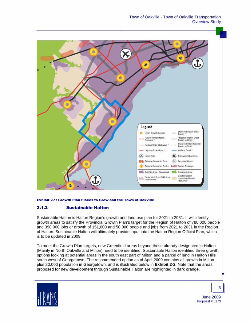
Adopted by Provincial Parliament in 2006, the Ontario Ministry of Public Infrastructure Renewal’s(MPIR) Places to Grow Act focuses on overcoming the problems of urban sprawl and gridlock in theGreater Golden Horseshoe (GGH) area by making communities more livable by providing more travelchoices and a greater mix of housing, parks and employment opportunities. This is to ensure theeconomic future and quality of life of the GGH to 2031 when an additional 3.7 million people areexpected to be living in the area.
The final Growth Plan for the Greater Golden Horseshoe was released in June 2006. Thefollowing objectives for municipal planning were highlighted in the press announcement – many ofwhich will affect the Town of Oakville:
Stimulate economic prosperity.
Encourage more compact communities, with services, shops and businesses close to home.
Preserve greenspace and agricultural lands that are under pressure in the GGH.
Curb urban sprawl and cut down on car dependency.
Contribute to better air quality.
Spur transit investment and create conditions favourable to public transit use.
Promote a culture of conservation.
Central to the Growth Plan is the concept of urban growth centres across the Greater Toronto Area(GTA) linked by transit supportive intensification corridors. Midtown Oakville is designated as onesuch urban growth centre, connected by high order transit to the City of Mississauga and the future401/407 employment area.
Exhibit 2-1 below shows the Town of Oakville in the context of the Growth Plan.
Town of Oakville - Town of Oakville TransportationOverview Study
3
June 2009Proposal # 5173
Exhibit 2-1: Growth Plan Places to Grow and the Town of Oakville
2.1.2 Sustainable Halton
Sustainable Halton is Halton Region’s growth and land use plan for 2021 to 2031. It will identifygrowth areas to satisfy the Provincial Growth Plan’s target for the Region of Halton of 780,000 peopleand 390,000 jobs or growth of 151,000 and 50,000 people and jobs from 2021 to 2031 in the Regionof Halton. Sustainable Halton will ultimately provide input into the Halton Region Official Plan, whichis to be updated in 2009.
To meet the Growth Plan targets, new Greenfield areas beyond those already designated in Halton(Mainly in North Oakville and Milton) need to be identified. Sustainable Halton identified three growthoptions looking at potential areas in the south east part of Milton and a parcel of land in Halton Hillssouth west of Georgetown. The recommended option as of April 2009 contains all growth in Miltonplus 20,000 population in Georgetown, and is illustrated below in Exhibit 2-2. Note that the areasproposed for new development through Sustainable Halton are highlighted in dark orange.

Town of Oakville - Town of Oakville TransportationOverview Study
4
June 2009Proposal # 5173
Exhibit 2-2: Sustainable Halton Recommended Land Use Option
The above graphic represents only the general areas for new mixed use/residential lands. Options forthe preferred concept will be subject to public consultation and are to be finalized later in 2009.Based on this plan, a significant amount of growth will be occurring directly north of the Town ofOakville. Future transportation infrastructure should accommodate and support this growth.Transportation infrastructure requirements were also analyzed as part of the Sustainable Haltoninitiative, and this component is summarized in Section 2.3.2.

Town of Oakville - Town of Oakville TransportationOverview Study
5
June 2009Proposal # 5173
2.2 Town of Oakville Intensification Areas
2.2.1 Bronte Village Revitalization Plan
Bronte Village is a unique area within the Town of Oakville with rich history, and is well situated onthe shore of Lake Ontario. The revitalization plan was initiated in 2004 in response to communityconcerns about development pressure and the need to increase the vibrancy of the local commercialarea. The study has since been completed and now recommends policies to be included in theLivable Oakville Plan to guide anticipated growth in Bronte Village.
The ultimate goal of the plan is for Bronte Village to be a vibrant community with a thrivingcommercial area with a variety of housing opportunities, providing year-round opportunities forresidents, workers, and visitors.
Key objectives include:
To nurture, conserve, and enhance a historic lakeside village character.
To revitalize the village and maintain a complete community.
To maintain and improve waterfront connections.
Key policy directions from the plan include:
The Lakeshore Road West corridor will be the focus for mixed use development.
Development will conserve and enhance village character and cultural heritage.
Public open space and streetscape improvements will be secured through development and willbe used to improve connectivity between the waterfront and commercial areas.
Growth and change will occur gradually over the long-term and will by linked to the provision ofinfrastructure such as transit, transportation, pedestrian, and cycling facilities.

Town of Oakville - Town of Oakville TransportationOverview Study
6
June 2009Proposal # 5173
The planned growth target for Bronte Village includes accommodating an additional 1,100 newresidential units and 900 jobs.
All growth will be monitored through Traffic Impact Studies required during the development processto ensure that the road network and transit service can accommodate the impacts to thetransportation network.
Exhibit 2-3 is the draft land use schedule resulting from the Bronte Village Revitalization study.
Exhibit 2-3: Bronte Village Revitalization Study – Draft Land Use Schedule
2.2.2 Kerr Village Plan
Kerr Village is an established downtown area with a main street of commercial uses, a wide range ofhousing types, and many community and institutional services. The goal is to revitalize Kerr Village tocreate a vibrant business district and cultural area.
Planning objectives include:
Create opportunities for new, sustainable growth by promoting compact urban form with higherdensity development through compatible redevelopment opportunities.
Enhance mobility of all users by providing transit priority measures and increasing levels ofservice through the development process.
Create an attractive public realm.

Town of Oakville - Town of Oakville TransportationOverview Study
7
June 2009Proposal # 5173
Key policy directions include:
Kerr Street south of Speers Road will be the focus for main street mixed use development.
Kerr street north of Speers Road will focus on transit oriented, high density mixed usedevelopment.
Alternate modes of transportation will be encouraged such as transit, cycling, and walking.
Development will transition in height between the main street areas and adjacent lower densityresidential neighbourhoods.
The planned growth target for Kerr Village includes accommodating an additional 2,100 newresidential units and 1,500 jobs.
Exhibit 2-4 below is the draft land use schedule for the Plan for Kerr Village.
Exhibit 2-4: Kerr Street Draft Land Use Schedule

Town of Oakville - Town of Oakville TransportationOverview Study
8
June 2009Proposal # 5173
2.2.3 Midtown Oakville
Midtown is located in between three residential communities: Iroquois Ridge South to the east,College Park to the north and Old Oakville to the south and bounded by Sixteen Mile Creek to thewest. These neighbourhoods are characterized by medium density residential and low density single-family homes. The district is constrained by barriers of the Queen Elizabeth Way (QEW) and the CNRail corridor.
Considering the barriers currently present in Midtown to accessibility and liveability, a number ofopportunities for improvement were identified. These opportunities were used as the basis for themajor infrastructure and land use changes this Plan recommends, aiming to increase access forpedestrians, transit users and cars, establish a Midtown identity, and lay the groundwork for a newgrowth centre.
It is a Town goal that the Midtown will become a diverse and attractive new centre for the Town ofOakville. The employment, civic, residential and commercial mix in Midtown will provide for a range ofopportunities for engagement and interaction among people who live, work and visit Midtown, leadingto its evolution into a community.
Midtown will complete a transit oriented community with high levels of public transit and pedestrianaccessibility. Service improvements to the Lakeshore West GO line, a dedicated right-of-way for thefuture Bus Rapid Transit system and convenient connections for transit riders will be the highlights ofpublic transportation in Midtown.
The vision for Midtown (Exhibit 2-5) is a transit centre that is more than a train platform surrounded bysurface parking. Complementary land uses are proposed, which incorporate a broader objective ofcreating Midtown into a transit centre with both seamless connections between multiple types oftransportation and a diverse, active, and a sustainable sense of place.
Exhibit 2-5: Midtown Oakville Official Plan Schedule

Town of Oakville - Town of Oakville TransportationOverview Study
9
June 2009Proposal # 5173
Midtown will be defined by high quality urban design. Civic buildings, offices, retail, commercial andresidential uses served with high levels of transit and vehicular accessibility will establish Midtown asa transit centre. Centres such as Midtown are akin to the mobility hubs identified by Metrolinx as oneof the basic building blocks of the Regional Transportation Plan. Mobility Hubs are to be focuses ofactivity where convenient connections to higher order transit, people’s places of work and residenceand day to day needs all come together, making getting around, doing business and everyday lifeeasier and more convenient.
To meet the Provincial growth targets identified in Places to Grow, development in the Urban GrowthCentre (UGC) boundary of Midtown will need to meet a target in excess of 5,500 new residential unitsand between 186,000 – 279,000 sq metres of office / commercial space by 2031.
Residential intensification will be directed to the west and southerly edges of the UGC, abutting therail corridor and 16 Mile Creek. In this peripheral location, higher buildings will have less of an impacton surrounding development and will also act to strongly define the edge of the Urban Growth Centre.Office intensification will be located in the central area of the Urban Growth Centre boundary withfrontage and an address on Trafalgar Road. The creation of residential and office uses adjacent tothe GO Station will make commuting by transit attractive and efficient. In addition, office uses will beintensified along the QEW corridor providing high visibility for potential tenants. Parking for the officecomplex can be provided on-site and in the hydro right-of-way corridor.
2.2.4 Uptown Core
Trafalgar Road and Dundas Street are the two main arterial roads bounding Oakville’s Uptown Corearea. Trafalgar Road is a four-lane north-south road and Dundas Street is a four-lane east-west road.In the period from 2009 to 2015, these roads will be widened to six lanes throughout the study area.The widening is also anticipated to include HOV lanes (which will ultimately be replaced with BusRapid Transit lanes) on Dundas Street and high-order transit services on Trafalgar Road.The configuration of the road network within the Uptown Core accommodates alternative travelmodes, including transit, a bikeway network and pedestrian provisions.
Local transit routes provide coverage such that most residences, schools, neighborhood centres andpublic facilities will be within a reasonable walking distance of a bus stop. A transit hub is already inplace which is supported with transit routing complimented with a comprehensive network ofsidewalks and sidewalk connections throughout the community to facilitate walking to transit stops.Providing convenient street-side bicycle lockup/locker facilities throughout the Central Retail area, aswell as at the transit hub, will add to the safety and attractiveness of alternative travel modes.
It is envisioned that high non-auto mode splits for the Uptown Core lands can be achieved as there isa comprehensive network of sidewalks and bikeways, transit services, a transit hub, HOV and/or BusRapid Transit lanes on the arterial corridors. The Uptown Core plans promote non-auto travel, suchas consolidated mixed-use development, creation of a “main street” community, and potentiallyreduced and maximum parking supply rates.
Exhibit 2-6 below shows the proposed concept plan for streets, blocks and land uses.

Town of Oakville - Town of Oakville TransportationOverview Study
10
June 2009Proposal # 5173
Exhibit 2-6: Uptown Core Official Plan Schedule
Section E of Oakville’s Official Plan positions the Uptown Core development framework as a regionalcentre with emphasis on commercial development (both retail and office) and a strong civic andpublic presence (government, institutional, cultural, recreational and public open space uses). Mixeduse development is encouraged in the Core.
Residential uses will range from high to medium although a full range of residential forms will bepermitted. The planned growth target for uptown Core includes accommodating at total of 16,000people and 3,000 jobs.
The Uptown Core is intended to function as a regional commercial node, as well as a community andneighbourhood centre. An estimated 28,000 jobs are anticipated to be generated in all commercialand other land use categories. The commercial component described in this section includesresidential and mixed-use destinations.
The development of additional commercial gross floor area shall be contingent upon the submissionof appropriate studies including a detailed Transportation Study illustrating that the additionalcommercial development can be absorbed by the transportation system existing at that time.
2.3 Transportation Planning Direction
Previous studies have provided direction in the development of the transportation system. TheOakville Transportation Master Plan 2007 provided planned direction for the development of theTown’s transportation infrastructure.

Town of Oakville - Town of Oakville TransportationOverview Study
11
June 2009Proposal # 5173
The Halton Transportation Master Plan in 2004 and 2007 and the Halton Region Strategic Planprovide direction on plans for regional infrastructure within the Town. The findings of plannedinfrastructure have been summarized in the development charges studies for Halton and Oakvillecompleted in 2004.
Since the completion of these studies, new initiatives have been undertaken including: MetrolinxRegional Transportation Plan (November 2008) – The Big Move, MTO QEW Widening EA (6 to 8lanes, with plans to use extra 2 lanes for HOV use), GO Transit plans for additional track, train andstation enhancements, and service improvements, the Oakville Transit 2008-2012 Service Plan(2008), Smart Commute Halton program, and the on-going Oakville Active Transportation MasterPlan. The implications of these studies are summarized below.
2.3.1 Halton Transportation Master Plan
The Region of Halton’s Regional Transportation Master Plan Study, initially completed in 2004, is atransportation strategy that considers all modes of travel, to meet the needs of Halton residents up tothe year 2021. The plan provides the tools needed to manage traffic safely, efficiently and costeffectively. An update to the Halton TMP Roads Capital Program was initiated in 2007 to update thetiming and need for road improvements out to 2021 as illustrated in Exhibit 2-7.
Exhibit 2-7: Halton TMP 2007 Update – Road Improvements

Town of Oakville - Town of Oakville TransportationOverview Study
12
June 2009Proposal # 5173
2.3.2 Sustainable Halton – Transportation Servicing
As part of Phase 3 of the Sustainable Halton initiative, a transportation servicing component wasundertaken to determine transportation infrastructure required. The future transportation conditionswere considered under two transit mode split scenarios 1) “trend” mode split based on 2006 TTS, and2) “enhanced” mode split, where mode split is increased to an average of 20% across the Region inthe peak hour. The results of the recommended option 2 illustrate a total of 13 screenlines acrossHalton being congested for the “trend” scenario. In comparison, 10 screenlines are congested in the“enhanced” scenario. Within Oakville, the screenline west of Bronte Creek shows 1 lane of deficiencyin both scenarios, while the screenline north of the QEW shows 1 lane of deficiency in “trend” and nodeficiency in “enhanced”.
2.3.3 Oakville Transportation Master Plan
Adopted by the Town of Oakville in 2007, the Oakville Transportation Master Plan establishestransportation policies and infrastructure plans for all travel modes in Oakville (vehicles, transit,cycling, walking) until 2021. Oakville’s TMP was first completed in 2004. The 2007 update to theTMP, recommended road and transit networks improvements provided below in Exhibit 2-8 andExhibit 2-9.
Exhibit 2-8: Oakville TMP 2021 Road Improvements
No significant changes to the proposed 2021 road improvements have been proposed from the 2004TMP to the 2007 TMP.

Town of Oakville - Town of Oakville TransportationOverview Study
13
June 2009Proposal # 5173
Exhibit 2-9: Oakville TMP 2021 Recommended Transit Service Concept
The 2007 TMP provides strategic policy directions dedicated to increasing transit usage specificallyby achieving the following objectives:
Regional and interregional transit linkages.
Inter-modal transfer locations supporting all local, regional, and interregional travel.
Land use patterns that support transit use for all trips.
Travel Demand Management (TDM) and Transportation Systems Management (TSM).
Introduction and expanded use of new technologies.
2.3.4 Metrolinx Regional Transportation Plan
In November of 2008, Metrolinx adopted a Regional Transportation Plan (RTP) for the GreaterToronto and Hamilton Area (GTHA), entitled The Big Move: Transforming Transportation in theGreater Toronto Area and Hamilton. The Plan calls for a multi-modal transportation system that:
Takes into account all modes of transportation.
Makes use of intelligent transportation systems.
Promotes the integration of local transit systems with each other and with GO Transit.
Works toward easing congestion and commute times, and reducing transportation-relatedemissions of smog precursors and greenhouse gases.
Promotes transit-supportive development and the viability and optimization of transitinfrastructure.
The RTP developed by Metrolinx is the third piece of the three-part approach by the Province ofOntario to prepare the GTHA for growth and sustainability, the first two of which are the 2005Greenbelt Plan, and the aforementioned 2006 Growth Plan for the Greater Golden Horseshoe.

Town of Oakville - Town of Oakville TransportationOverview Study
14
June 2009Proposal # 5173
Nine priority actions or Big Moves are identified in the Plan – concrete actions that comprise a “to-do”list needed to implement the overall strategy.
The nine Big Moves are:1. A fast, frequent and expanded region rapid transit network.2. High-order transit connectivity to the Pearson Airport district from all directions.3. An expanded Union Station – the heart of the GTHA’s transportation system.4. Complete walking and cycling networks with bike-sharing programs.5. An information system for travellers, where and when they need it.6. A region-wide integrated transit fare system.7. A system of connected mobility hubs.8. A comprehensive strategy for goods movement.9. An investment strategy to provide immediate, stable, and predictable funding.
A number of key policies based upon these Big Moves are set forth in the Plan and are considered inthe development of the Oakville Transportation Overview Study.
Exhibit 2-10 below shows the Town of Oakville in the context of the Metrolinx 25-year plan.
Exhibit 2-10: Metrolinx RTP 25-year Plan and the Town of Oakville

Town of Oakville - Town of Oakville TransportationOverview Study
15
June 2009Proposal # 5173
2.3.5 QEW HOV Widening, Oakville to Burlington
As part of the Ontario Ministry of Transportation’s Southern Highways Program, the QEW fromTrafalgar Road to Guelph Line is being widened from six lanes to eight lanes. The new lanes will befor High Occupancy Vehicles or HOV in both the eastbound and westbound directions. These newlanes require the widening of the Bronte Creek and Sixteen-Mile Creek bridges, and in total will run16.3 km in each direction.
The widening of the QEW for HOV instead of General Purpose Lanes (GPL) will have implications onthe transportation capacity of the corridor. Since the most recent version of the Oakville TMPassumed widening for GPL and not HOV, this Transportation Overview will look at the impacts ofHOV on the east-west traffic screenlines across Bronte Creek and Sixteen-Mile Creek. The changewill likely have the greatest impacts upon Lakeshore Road, Rebecca Street, Speers Road, and theproposed Wyecroft extension across Bronte Creek.
2.3.6 GO Transit Plans
GO Transit has developed a $1.7 billion capital plan to deal with growth on the GO rail and bussystem until 2016. This plan, developed in conjunction with the GTA municipalities and dependent onone-third funding from each of the federal, provincial and municipal sectors, includes components onimprovements for each corridor, bus and train upgrades, and extra-GTA expansion. Particularemphasis is given to implementation of the GO TRIP (Transit Rail Improvement Program), whichincreases capacity of existing rail lines through methods such as grade separation, additional tracksand layover spaces, and improvements to the hub at Union Station to enable it to cope with up to 80million passengers (double existing capacity). Acquiring new rail equipment and implementing busrapid transit programs are also focuses of the 10-year plan.
The plan features the following initiatives:
$580 million for GO TRIP (rail) expansion, which includes:
Track improvements on Lakeshore West GO line to allow for more frequent service,increased reliability and extension of service hours to include midday trains, throughseparation from freight trains on parallel tracks and grade separation at crossovers.
Improved train storage facility on the Milton line.
$35 million expansion of parking capacity, $14 million of which is for improvements to the parkingstructure at the Oakville GO Station – part of the plans for intensification in Midtown Oakville.
$500 million investment in new rail equipment, including coaches, locomotives and maintenancefacilities.
$165 million for bus rapid transit routes.
$37 million for new buses.
The improvement of the service on the Lakeshore West GO line, in particular, featuring extendedservice hours and faster travel, aims to provide a more convenient and reliable link between Oakville(and the other municipalities to the west) and Toronto.
2.3.7 Oakville Transit Service Plan
The Oakville Transit 2008-2012 Service Plan is created as a short term plan within the framework ofthe Town of Oakville’s longer term transit plans. This updated Service Plan is formed on the basis ofthe Oakville TMP and the North Oakville Secondary Plan (NOSP).

Town of Oakville - Town of Oakville TransportationOverview Study
16
June 2009Proposal # 5173
The TMP outlines a hierarchy of services to be achieved over the next 15 years, including primarycorridors on Trafalgar and Dundas that will have dedicated lanes and signal priority. Secondarycorridors are to exist on most of the remaining east-west and north-south arterials and will have goodservice levels of 10 to 15 minute headways.
The largest change from existing Oakville Transit service will be the adoption of a more grid basedsystem as opposed to the previous radial system. This change also results in a significantimprovement to the level of off-peak service.
The proposed transit route network for the year 2012 is shown below in Exhibit 2-11.
Exhibit 2-11: 2012 Oakville Transit Route Network

Town of Oakville - Town of Oakville TransportationOverview Study
17
June 2009Proposal # 5173
2.3.8 Smart Commute Halton
To help reduce traffic congestion and improve air quality, Halton Region is participating in the SmartCommute Initiative, Canada’s largest transportation demand reduction program with participationacross the entire GTA.
The Smart Commute Halton TMA has begun with the set-up of a Travel Demand Management (TDM)program for employees at the Halton Regional Centre and the Woodlands Operation Centre.Initiatives currently available include:
Carpool / Ridematching Service
Preferential carpool parking
Emergency Ride Home Program
Improved transit service
Sale of transit tickets/passes
Bike lockers at auditorium entrance
2.3.9 Oakville Active Transportation Master Plan
The Town of Oakville Active Transportation Master Plan (ATMP) aims to develop a convenient andefficient Town-wide cycling and pedestrian system that links all communities in the Town.
The draft vision for Phase 1 of the study (September 2008) states that “The Town of Oakville is apedestrian and cycling supportive community that encourages active transportation for both utilitarianand recreational travel through:
Ensuring that every street accommodates pedestrians and cyclists.
Established promotional and educational policies and programs including a coordinatedmarketing strategy to encourage active transportation year-round.
A Town-wide visible and connected active transportation network of on-road and off-road facilitiesdesigned with safety in mind that are comfortable, convenient, and accommodate the needs ofexisting and future users.
Approved Official Plan policies and associated strategies which recognize that great placesrequire pedestrian and cycling friendly land development and streetscape design that supportsthe Town of Oakville’s vision to become the most livable Town in Canada.
The draft active transportation plan is illustrated below in Exhibit 2-12.

Town of Oakville - Town of Oakville TransportationOverview Study
18
June 2009Proposal # 5173
Exhibit 2-12: Draft Active Transportation Network

Town of Oakville - Town of Oakville TransportationOverview Study
19
June 2009Proposal # 5173
3. TRANSPORTATION CONDITIONS &
TRENDS
Transportation data was reviewed, including 2006 Transportation Tomorrow Survey, to providesummaries that assess travel characteristics and trends in Oakville over a 5 year period. The reviewincluded: the magnitude of trip making by mode, trip distribution (inbound, outbound and through theTown), and trip length. The analysis includes an assessment of vehicle ownership and the effect oftrip length and purpose on modal choice.
For this type of analysis it may be more common to analyse weekday AM and PM peak hours ratherthan peak periods. However, Oakville has two traffic volume peaks in the PM; each one smaller inmagnitude than the one AM peak, and therefore, an analysis of peak periods provides a moreaccurate account of travel characteristics. The AM and PM peak periods have been defined as 6:00AM to 8:59 AM and 3:30 PM to 6:29 PM respectively. Where peak hour is mentioned, it is defined asAM from 7:30 AM to 8:29 AM and PM from 4:45 PM to 5:44 PM.
The analysis is completed for travel between Oakville and the Greater Toronto Area (GTA) as well asHamilton and Niagara, unless stated otherwise. Modal split is the first travel characteristic examined,followed by trip origin and destination. An analysis combining travel mode and travel destination wasexamined next. A separate analysis dedicated to work trips follows. The Town was divided into 17zones and an origin-destination study for travel between and within these zones was conducted. Thememorandum is completed by a discussion of trip lengths and concluding statements.
3.1 Modal Split
The analysis of modal splits (percentage of travel by mode) in the Town of Oakville was conducted bycollecting data on inbound and outbound trips for the AM and PM peak periods. The travel modesconsidered are automobile (driver and passenger), local transit, GO Transit, and non-motorized (walkand cycle) and other.
Travel to and from Oakville is largely dominated by the personal automobile. The automobile modalshare ranges from 79% for AM peak period outbound trips to 91% for PM peak period outbound trips.Walk-Cycle-Other was the next most used mode ranging from 5% of inbound trips in the PM to 11%of inbound trips in the AM. GO Transit followed a commuter travel pattern as it only has a significantpresence in the data for outbound trips in the AM and inbound trips in the PM at 8% and 6%respectively. Local transit has steady use throughout the day peaking at 2% for inbound trips in theAM peak period.
The overall volume is greater during the PM peak period than the AM peak period, as indicated by themore than 97,000 trips inbound in the PM compared to 90,000 outbound in the AM.
The 2006 trips by mode were compared to the 2001 data presented in the Transportation MasterPlan. The modal split breakdown is similar indicating little or no change in travel behaviour within theTown as summarized in Table 3-1 . The results indicate a marginal increase in the percentage ofwalk and cycle trips and a marginal decrease in the percentage of GO Transit trips in the PM peak.

Town of Oakville - Town of Oakville TransportationOverview Study
20
June 2009Proposal # 5173
Mode
AM PeakPeriodTrips %
PM PeakPeriodTrips %
Outbound Inbound Outbound Inbound Outbound InboundAutomobile 79% 86% 92% 87% 78% 87%Local Transit 2% 2% 2% 1% 2% 1%GO Transit 8% 1% 1% 6% 9% 8%Walk-Cycle-Other 11% 11% 6% 5% 11% 4%
Total100%
(90,802)100%
(86,085)100%
(93,359)100%
(97,399)100%
(77,655)100%
(58,672)
2006 2001
AM Peak Period Trips%
PM Peak Period Trips%
Table 3-1: Modal Share Summary
Source: 2006 TTS (2006) and Town of Oakville TMP 2007 (2001).
3.2 Trip Distribution
3.2.1 Origin-Destination Patterns
An analysis summarizing modal splits was conducted for travel between Oakville and the GTA for alltrip purposes. The analysis was conducted for both AM and PM peak periods.
Considering all trip purposes (work, school, shopping, other), there is a high percentage of tripsoriginating in Oakville and destined to Oakville. This suggests a high degree of “self-containment”.Trips that start and end in Oakville, ranging from 56% to 61% of all trips (Table 3-2).
The majority of trips leaving Oakville are destined to nearby communities within Halton and PeelRegions, particularly trips to Mississauga, which represents a 17.7% share of outgoing AM peakperiod trips and an 18.9% share of inbound PM peak period trips. For other municipalities, Oakville isan attractor of trips, with more trips destined for Oakville during the AM peak period and leavingOakville during the PM peak period than the reverse.
Oakville also has a significant commuter travel pattern with the City of Toronto as shown by the highproportion of outbound trips to Toronto during the AM peak period (9.7% of all trips) and inbound fromToronto during the PM peak period (7.7% of all trips). There is a negligible reverse travel patterninbound AM and outbound PM trips (0.5% and 1.1% of all trips, respectively).

Town of Oakville - Town of Oakville TransportationOverview Study
21
June 2009Proposal # 5173
Table 3-2: Trip Distribution
Origin / Destination Outbound Inbound Outbound InboundDowntown Toronto 10% 0% 1% 8%Rest of Toronto 6% 3% 4% 6%Durham 0% 0% 0% 0%York 1% 1% 1% 1%Mississauga 16% 13% 14% 17%Brampton 2% 2% 2% 2%Peel 18% 15% 16% 19%Oakville 57% 61% 59% 56%Burlington 4% 10% 10% 6%Milton 1% 2% 2% 1%Halton Hills 0% 1% 1% 0%Halton 63% 74% 72% 64%Hamilton Area 2% 6% 5% 2%Niagara Region 0% 1% 1% 0%
Total 100% 100% 100% 100%
AM Peak Period Trips % PM Peak Period Trips %
3.2.2 Modal Splits & Trip Distribution
An analysis cross referencing modal splits and origin-destination information was conducted for travelbetween Oakville and the GTA. The analysis was done for both AM and PM peak periods.
For the AM peak period, automobile traffic was heavily used for trips in Halton and Peel Region.There is a slightly higher proportion of automobile trips inbound than outbound during the AM peakperiod (71% and 64% respectively) for trips in Halton Region. The modal share of automobile tripsoutbound to Peel Region is higher than trips inbound from Peel Region. Small proportions of overallauto traffic make their way to and from the other districts in the study area.
Local transit trips in the AM peak period show a strong commuter travel connection to Mississauga.Inbound trips from Mississauga account for nearly 29% of local transit trips while outbound trips toMississauga account for 9% of transit trips. 80% of outbound trips and 63% of inbound trips are withinOakville.
GO Transit trips are connected with movement to and from Toronto. For the AM peak period,outbound trips destined for Downtown Toronto account for more than 91% of all GO Transit trips.Another 7% are destined for the rest of Toronto. Inbound trips to Oakville by GO Transit are 32% fromToronto (outside of Downtown) and 14% from Peel Region. Nearly 12% came from DowntownToronto.
For cycling, walking and other methods of travel, over 95% of outbound trips and over 96% ofinbound trips are within Oakville and the rest are primarily to and from Mississauga and Burlington(Table 3-3).

Town of Oakville - Town of Oakville TransportationOverview Study
22
June 2009Proposal # 5173
Table 3-3: AM Peak Period Distribution by Mode – All Trip Purposes
Outbound Inbound Outbound Inbound Outbound Inbound Outbound InboundDowntown Toronto 3% 0% 1% 0% 90% 12% 0% 0%Rest of Toronto 7% 4% 5% 3% 7% 32% 0% 0%Durham 0% 0% 0% 0% 0% 0% 0% 0%York 1% 1% 0% 0% 0% 0% 0% 0%Mississauga 20% 14% 9% 28% 1% 11% 2% 2%Brampton 2% 2% 0% 1% 0% 3% 0% 0%Peel 22% 16% 9% 29% 1% 14% 3% 2%Oakville 57% 56% 80% 63% 0% 0% 95% 96%Burlington 5% 11% 4% 1% 1% 21% 1% 1%Milton 1% 2% 0% 0% 0% 0% 0% 0%Halton Hills 0% 1% 0% 0% 0% 0% 0% 0%Halton 64% 71% 84% 64% 1% 21% 96% 98%Hamilton Area 2% 7% 1% 3% 1% 21% 1% 0%Niagara Region 0% 1% 0% 0% 0% 0% 0% 0%
Total 71,183 72,643 1,443 1,828 7,299 650 9,873 9,757
AM 2006Automobile Local Transit GO Transit Cycle-Walk-Other
Similar distributions for the reverse movements are observed for the PM peak period as summarizedin Table 3-4.
Table 3-4: PM Peak Period Distribution by Mode – All Trip Purposes
Outbound Inbound Outbound Inbound Outbound Inbound Outbound InboundDowntown Toronto 1% 2% 0% 2% 27% 90% 0% 0%Rest of Toronto 4% 6% 2% 6% 29% 7% 1% 0%Durham 0% 0% 0% 0% 0% 0% 0% 0%York 1% 1% 0% 0% 0% 0% 0% 0%Mississauga 14% 19% 34% 14% 15% 1% 3% 4%Brampton 2% 2% 3% 0% 3% 0% 0% 0%Peel 16% 21% 37% 14% 18% 1% 4% 4%Oakville 57% 58% 58% 73% 0% 0% 94% 94%Burlington 11% 7% 3% 1% 15% 1% 2% 1%Milton 2% 1% 0% 0% 0% 0% 0% 0%Halton Hills 1% 1% 0% 0% 0% 0% 0% 0%Halton 71% 67% 61% 74% 15% 1% 96% 95%Hamilton Area 6% 2% 0% 3% 12% 1% 0% 1%Niagara Region 1% 0% 0% 0% 0% 0% 0% 0%
Total 84,246 83,547 1,640 1,294 710 6,242 5,200 5,176
PM 2006Automobile Local Transit GO Transit Cycle-Walk-Other
3.2.3 Work Trips (OD – Modal Split)
In considering trips made only for the purpose of traveling to and from work, there is a much higherpercent of travel outside of Oakville. The proportion of AM outbound auto trips to Peel region is muchlarger than overall trip purposes, representing more than 1/3 of auto trips and as many auto trips astrips from Oakville to Oakville. The proportion of auto trips to and from Halton Region are 55% and44% respectively. Trips from Burlington to Oakville in the AM peak period (18% of work trips)represent a significant inflow of commuter trips.

Town of Oakville - Town of Oakville TransportationOverview Study
23
June 2009Proposal # 5173
The percentage of work trips made by local transit indicate that local transit travel is primarily withinOakville or to and from the City of Mississauga. Despite the high number of automobile trips fromBurlington to Oakville in the AM peak hour, there is limited local transit travel between Burlington andOakville.
For GO Transit, cycling, walking and other modes of transportation, there are only slight differencesfor inbound trips for work based trips and other purpose trips. It is noted that the proportion ofoutbound walking and cycling trips to outside of Halton Region is negligible (Table 3-5).
Table 3-5: AM Peak Period Distribution by Mode – Work Trip Purpose
Outbound Inbound Outbound Inbound Outbound Inbound Outbound InboundDowntown Toronto 4% 1% 0% 0% 92% 13% 0% 0%Rest of Toronto 9% 6% 0% 5% 6% 34% 0% 0%Durham 0% 0% 0% 0% 0% 0% 0% 0%York 2% 2% 0% 0% 0% 0% 0% 0%Mississauga 34% 19% 20% 38% 1% 16% 0% 5%Brampton 2% 3% 0% 0% 0% 0% 0% 0%Peel 36% 22% 20% 38% 1% 16% 0% 5%Oakville 35% 31% 80% 50% 0% 0% 100% 92%Burlington 9% 18% 0% 2% 2% 28% 0% 2%Milton 1% 3% 0% 0% 0% 0% 0% 0%Halton Hills 0% 2% 0% 0% 0% 0% 0% 0%Halton 45% 55% 80% 52% 2% 28% 100% 95%Hamilton Area 5% 12% 0% 5% 0% 10% 0% 0%Niagara Region 0% 1% 0% 0% 0% 0% 0% 0%
Total 13,684 33,118 83 774 2,231 440 340 770
AM Work Trips 2006Automobile Local Transit GO Transit Cycle-Walk-Other
Similar distributions for the reverse movements are observed for the work trip PM peak period assummarized in (Table 3-6).
Table 3-6: PM Peak Period Distribution by Mode – Work Trip Purpose
Outbound Inbound Outbound Inbound Outbound Inbound Outbound InboundDowntown Toronto 1% 4% 0% 6% 18% 91% 0% 0%Rest of Toronto 6% 11% 7% 9% 38% 7% 0% 0%Durham 1% 0% 0% 0% 0% 0% 0% 0%York 1% 3% 0% 0% 0% 0% 0% 0%Mississauga 18% 30% 28% 20% 16% 0% 9% 4%Brampton 4% 3% 0% 0% 0% 0% 0% 0%Peel 22% 33% 28% 20% 16% 0% 9% 4%Oakville 34% 35% 62% 65% 0% 0% 90% 96%Burlington 16% 8% 3% 0% 22% 1% 2% 0%Milton 3% 2% 0% 0% 0% 0% 0% 0%Halton Hills 2% 0% 0% 0% 0% 0% 0% 0%Halton 55% 45% 65% 65% 22% 1% 91% 96%Hamilton Area 12% 3% 0% 0% 6% 0% 0% 0%Niagara Region 2% 0% 0% 0% 0% 0% 0% 0%
Total 30,080 29,048 569 543 392 5,170 976 910
PM Work Trips 2006Automobile Local Transit GO Transit Cycle-Walk-Other

Town of Oakville - Town of Oakville TransportationOverview Study
24
June 2009Proposal # 5173
3.2.4 Internal Oakville Trips
Internal trips are those trips that start and end within Oakville. The proportion of internal trips is animportant indicator of the degree of “self-containment”. The Town was divided into 17 zones based onneighbourhood units and functional areas and an origin-destination analysis of internal movementswas completed for the PM peak period. This analysis has two elements—a review of trips leavingzones and a review of trips entering zones.
Slightly over 53,000 trips are made internal within Oakville during the PM peak period. The volume ofoutbound trips, trips leaving zones, from the top 5 employment zones account for approximately 55%of all trips. The top 5 are: River Oaks Wedgewood Creek (6,446 trips), College Park Flapperwood(6,315 trips), South Central Oakville (5,866 trips), Glen Abbey (5,863 trips), and Southeast Oakville(4,827). These 5 zones are also among the 7 zones that had 30% or more trips that started andended in the same zone. There are notable connections between particular zones. Nearly half of alltrips leaving the Burloak Employment Area were bound for Bronte Village. Over 30% of trips leavingBronte Village were bound for South Central Oakville. Nearly 38% of trips leaving QEW East CornwallEmployment area were bound for South Central Oakville. Slightly less than 30% of trips leaving theUptown Core were bound for River Oaks Wedgewood Creek.
For trips entering zones, inbound trips, the top 5 residential zones account for approximately 62% ofall trips. The top 5 zones are: River Oaks Wedgewood Creek (7,465 trips), South Central Oakville(7,027 trips), College Park Flapperwood (6,858 trips), Glen Abbey (6,697 trips), and SoutheastOakville (5,074 trips). Except for Southeast Oakville, these zones are the 4 that had 30% or moretrips that started and ended in the same zone. There are also some noticeable connections for thispart of the analysis. Over 57% of trips arriving in Burloak Employment Area in the PM are fromCollege Park Flapperwood, and the rest originate in West Oak Trails. Over 38% of trips arriving in theQEW East Cornwall Employment Area originated in Southeast Oakville. Over 36% of trips arriving inNorth Oakville came from River Oaks Wedgewood Creek. Nearly 30% of trips arriving in BronteVillage came from South Central Oakville (Table 3-7)
The intensification areas that were studied currently have low to moderate self containment. Thepercentages of trips destined to the intensification area that originate in the intensification area arenoted below:
Bronte Village 23% of inbound trips are from within the district
Kerr Street 10% of inbound trips are from within the district
Midtown 10% of inbound trips are from within the district
Uptown 18% of inbound trips are from within the district

Town of Oakville - Town of Oakville Transportation Overview Study
25
June 2009Proposal # 5173
Table 3-7: Distribution of Trips within Oakville – PM Peak Period
FROM TO ---> Bro
nte
Vill
ag
e
Ke
rrS
tre
et
Old
Oa
kvill
e
Mid
tow
nC
ore
Up
tow
nC
ore
Bu
rlo
ak
Em
p.
Are
a
QE
WW
Sp
eers
Rd
Em
p.A
rea
So
uth
Ce
ntr
al
Oa
kv
ille
Gle
nA
bb
ey
We
st
Oa
kT
rail
s
Riv
er
Oa
ks
We
dg
ew
oo
dC
ree
k
Co
lleg
eP
ark
Fla
pp
erw
oo
d
QE
WE
Co
rnw
all
Em
p.
Are
a
So
uth
Ea
st
Oa
kv
ille
Sh
erw
oo
dH
eig
hts
Win
sto
nP
ark
Em
plo
ym
ent
Are
a
No
rth
Oa
kvill
e
Bronte Village 672 0 59 65 0 0 75 625 125 86 50 174 0 80 16 0 0 2,027Kerr Street 36 169 83 73 41 0 70 350 160 280 53 171 15 214 0 0 0 1,715Old Oakville 55 110 156 54 50 0 35 301 70 131 85 229 46 362 16 31 0 1,731Midtown Core 16 88 97 186 86 0 65 346 343 94 549 534 32 392 80 116 20 3,044Uptown Core 0 31 16 33 319 0 0 85 142 56 543 454 0 97 0 0 56 1,832Burloak Employment Area 72 0 0 0 0 0 0 0 19 37 0 17 0 0 0 0 0 145QEW W Speers Rd Employment Area 366 230 134 88 80 0 92 623 558 411 473 439 32 186 16 17 16 3,761South Central Oakville 878 229 165 89 32 0 186 2,228 611 313 274 281 65 343 64 50 58 5,866Glen Abbey 72 198 68 105 71 0 213 449 2,526 818 356 449 68 300 32 53 85 5,863West Oak Trails 138 131 75 241 75 37 224 258 496 1,420 234 255 0 102 16 94 56 3,852River Oaks Wedgewood Creek 49 54 64 169 446 0 106 371 457 202 2,924 1,035 0 194 32 88 255 6,446College Park Flapperwood 203 165 246 287 303 50 66 469 340 463 891 2,018 98 415 159 73 69 6,315QEW E Cornwall Employment Area 143 54 0 31 33 0 17 233 72 56 122 101 62 639 96 31 0 1,690South East Oakville 157 193 352 300 146 0 31 426 262 166 213 356 367 1,460 363 0 35 4,827Sherwood Heights 0 16 0 48 0 0 48 67 118 91 136 80 112 156 191 32 36 1,131Winston Park Employment Area 36 0 62 21 64 0 0 104 218 224 273 133 62 67 175 198 15 1,652North Oakville 38 21 16 0 17 0 0 92 180 131 289 132 0 67 121 0 0 1,104
2,931 1,689 1,593 1,790 1,763 87 1,228 7,027 6,697 4,979 7,465 6,858 959 5,074 1,377 783 701
TO
TA
LO
UT
BO
UN
DT
RIP
S
TOTAL INBOUND TRIPS

Town of Oakville - Town of Oakville TransportationOverview Study
26
June 2009Proposal # 5173
3.2.5 Trip Lengths
For trips that were made within the Town of Oakville, the mode of travel was compared to thedistance travelled (Table 3-8). In the PM peak period, automobiles accounted for 100% of trips morethan 10 km long, and more than 93% of all trips over 1 km long. The majority of transit trips were inthe 1km to 10 km length. Cycling, walking and other forms of transportation accounted for 22% oftrips up to 1 km in length and over 4% of trips between 1 km and 5 km.
Table 3-8: Travel Distance for Internal Trips – PM Peak Period
Travel Distance for Internal Trips
0 to 1 km 1 to 5 km 5 to 10 km 10 to 15 km
Auto 77.16% 93.48% 95.75% 100.00%
Transit 0.60% 2.28% 2.06% 0.00%Cycle-Walk-Other 22.24% 4.24% 2.19% 0.00%
For inbound and outbound work related trips related to work are most frequently shorter than 10 kmrange. Few work trips are longer than 40 km. The vast majority of school based trips are shorter than10 km. Other purpose trips to or from home (e.g. shopping visiting, recreation) are also primarily lessthan 10 km in length as illustrated in Exhibit 3-1.
Exhibit 3-1: Trip Length by Purpose – PM Peak Period
Trip Lengths Originating in Oakville PM period
0
5000
10000
15000
20000
25000
30000
0 - 10 km 10 - 20 km 20 - 30 km 30 - 40 km 40 - 50 km 50 - 60 km 60 + km
Nu
mb
er
of
Tri
ps
Work Trips
School Trips
Home based OtherTripsNon Home basedTrips
Trip Lengths Destined for Oakville PM period
0
5000
10000
15000
20000
25000
30000
0 - 10 km 10 - 20 km 20 - 30 km 30 - 40 km 40 - 50 km 50 - 60 km 60 + km
Nu
mb
er
of
Tri
ps
Work Trips
School Trips
Home based OtherTripsNon Home basedTrips

Town of Oakville - Town of Oakville TransportationOverview Study
27
June 2009Proposal # 5173
3.2.6 Active Transportation Comparison
The cycling activity within the Town of Oakville and other Greater Toronto Area (GTA) jurisdictions isnoted below (Table 3-9).
Table 3-9: Percentage of Cycling Daily Travel
Municipality Bicycle Mode Share
Oakville 0.40%
Mississauga 0.27%
Brampton 0.29%
Vaughan 0.19%
Markham 0.17%
Toronto 1.04%
Hamilton 0.65%
Burlington 0.39%
Pickering 0.21%
Mean 0.40%
Mean (excluding Toronto) 0.32%
Oakville currently has a higher level of active transportation use than comparable municipalities, butlower activity than the City of Toronto and City of Hamilton that have more extensive cyclinginfrastructure and more fully developed communities.
3.3 Summary of Trends and Opportunities
The Transportation Tomorrow Survey data indicated that the travel characteristics in Oakville havenot changed substantially between 2001 and 2006. The percentage of travel by automobile remainshigh, at approximately 79%. The percentage of travel by GO Transit, 8% of outbound trips in the AMpeak hour, demonstrates potential for other forms of transit travel.
A large percentage of trips are short distances, less than 10 km. Walking and cycling represent 22%of trips less than 1 km and 4% of trips 1-5%. The majority of school trips and other purpose trips(shopping, recreation, visiting) are less than 10 km in length.
The percentage of AM peak period trips from Oakville that remain within Oakville is 57% and isconsidered substantial. Other key destinations include the City of Mississauga 16% of trips anddowntown Toronto 10%. AM auto trips to Oakville include a large percentage originating from the Cityof Burlington. There is limited travel from Burlington to Oakville on transit.
The high percent of trips from Oakville remaining in Oakville is consistent with the short trip length ofa large percent of trips. There are opportunities to reduce travel by encouraging development thatresults in shorter trips that can be made by non-auto modes. The intensification areas have thepotential for higher levels of self containment, and the design and provision of infrastructure shouldreflect this opportunity.

Town of Oakville - Town of Oakville TransportationOverview Study
28
June 2009Proposal # 5173
4. TRANSPORTATION DIRECTIONS
4.1 Required Transportation Infrastructure
4.1.1 Transportation Master Plan Findings
The Oakville Transportation Master Plan 2007 included screenline capacity analysis to determinetransportation network needs through to the year 2021. The analysis indicated that withouttransportation improvements, there will be transportation capacity constraints throughout the Town oneast-west corridors crossing Bronte Creek, Sixteen Mile Creek, Third Line, Fourth Line and NinthLine. There will also be capacity constraints across the QEW. The TMP confirmed that even withenhanced transit operations that capacity constraints are anticipated crossing these screenlines.
The identified Provincial and Regional road capacity improvements are summarized in Table 4-1. Thefindings supported the need for a Burnhamthorpe Road (or New North Oakville TransportationCorridor) crossing of Sixteen Mile Creek.
Table 4-1: Transportation Master Plan Recommended Road Improvements
Corridor Road SectionQEW Highway 403 in Oakville to Highway 403 in Burlington, Widen from 6 to 8 lanesTrafalgar Road Iroquois Shore Rd. to Upper Middle Rd. Widen from 4 to 6 lanesTrafalgar Road Upper Middle Rd. to Dundas St. Widen from 4 to 6 lanesTrafalgar Road Dundas St. to Highway 407 Widen from 4 to 6 lanesJames Snow Parkway Britannia Rd. to Highway 407 New 2-lane constructionNeyagawa Boulevard Dundas St. to Burnhamthorpe Rd. Widen from 2 to 4 lanesBurnhamthorpe Road Bronte Road to Ninth Line Widen from 2 to 4 lanes, including new Sixteen Mile
Creek structureDundas Street Neyagawa Blvd. to Proudfoot Trail Widen from 4 to 6 lanes, including new
Sixteen Mile Creek structureDundas Street Neyagawa Blvd. to Oak Park Blvd. Widen from 4 to 6 lanesDundas Street Oak Park Blvd. to Highway 403 Widen from 4 to 6 lanesDundas Street Proudfoot Trail to Bronte St. Widen from 4 to 6 lanesDundas Street Bronte St. to Tremaine Rd. Widen from 4 to 6 lanesNinth Line Upper Middle Rd. to Dundas St. Widen from 2 to 4 lanesDorval Drive Wyecroft Rd. to N. Service Rd. Widen from 4 to 6 lanesDorval Drive Speers Rd. to Wyecroft Rd. Widen from 4 to 6 lanesBurloak Drive QEW to Upper Middle Rd. Widen from 2 to 4 lanesBronte Road Upper Middle Rd. to Highway 407 Widen from 2 to 4 lanesBronte Road QEW to Upper Middle Rd. Widen from 2 to 4 lanesUpper Middle Road Bronte Rd. to Postmaster Widen from 2 to 4 lanesUpper Middle Road Winston Park Dr. to Winston Churchill Blvd. Widen from 2 to 4 lanesUpper Middle Road Grand Blvd. to Ninth Line/Ford Dr. Widen from 4 to 6 lanesUpper Middle Road Trafalgar Rd. to Neyagawa Blvd. Widen from 4 to 6 lanes
The TMP confirmed the need for the Town of Oakville road infrastructure including a Midtowncrossing of the QEW, connecting Iroquois Shore Road to Royal Windsor Drive and a Wyecroft Road– Harvester Road connection across Bronte Creek is needed within the period to 2021.

Town of Oakville - Town of Oakville TransportationOverview Study
29
June 2009Proposal # 5173
4.1.2 Implications of HOV Operations
With the transportation improvements identified in the Transportation Master Plan and with a shifttoward increased use of alternative modes, the V/C ratio of each screenline analysed was projectedto meet or be better than the level of service threshold of 0.90 (90% of capacity). However, it is notedthat the additional lanes planned on Dundas Street and on the QEW are proposed for HighOccupancy Vehicle (HOV) lane operations. The TMP did not include capacity adjustments for HOVoperations on Dundas Street or the QEW.
It is anticipated that the HOV lanes on both corridors will be implemented as a 2-plus (vehicles with 2or more passengers) operation initially with the possibility of increasing to 3-plus when there issufficient demand. For the Dundas Street corridor, conversion to reserved bus lanes (RBL) or busrapid transit will be considered when there is sufficient transit demand in the corridor. It is estimatedthat HOV lanes or RBL operate most effectively at or below 60% of a general purpose lane maximumvolume (1100 vehicles per hour for freeway lanes, 500 vehicles per hour for arterial lanes) to producetravel time benefits for high occupancy vehicles. With a capacity adjustment to reflect HOVoperations, the Sixteen Mile Creek North and South screenlines will exceed planned capacity by onevehicle lane.
Opportunities to address the potential capacity constraints across Sixteen Mile Creek include:
Widening Speers Road to 6 lanes across Sixteen Mile Creek.
Widening Upper Middle Road to 6 lanes across Sixteen Mile Creek.
A further widening of the Queen Elizabeth Way to 10 lanes through Oakville
An EA for a new roadway across Sixteen Mile Creek (in addition to Burnhamthorpe Road)
Policies to maximize use of existing arterials.
The option of Widening Upper Middle Road is a feasible option. The existing road right-of-way andstructure appears sufficiently wide to accommodate an additional lane per direction betweenNeyagawa Boulevard and Dorval Drive.
Additional capacity on Upper Middle Road and Dorval Drive would be consistent with the dualfunction that Upper Middle Road serves in this section of the corridor; it 1) provides continuity ofcapacity of four east-west lanes and 2) provides north-south connectivity of the arterial road systembetween Neyagawa Boulevard and Dorval Drive.
Speers Road is a key east-west corridor south of the QEW. Immediately east of Sixteen Mile Creek, itfeeds two east-west corridors Cornwall Road and Cross Avenue, both of which provide access to theOakville GO Rail Station and bus terminal. The provision of additional capacity on Speers Roadacross Sixteen Mile Creek would provide greater lane continuity with Cornwall Road and CrossAvenue to the east. Additional capacity could also provide opportunities for transit priority for busesaccessing the GO Station.
Further widening of the QEW within Oakville, beyond the planned eight lanes, would be appropriategiven the high traffic demand traveling through the Town of Oakville. However, there are no currentprovincial commitments or plans for further widening of the QEW.
The current plan for North Oakville does not include additional crossings of Sixteen Mile Creek,beyond the New North Oakville Transportation Corridor / Burnhamthorpe Road. There are significantenvironmental constraints to the corridor. Furthermore, it is anticipated that the Highway 407 willcontinue to operate with reserve capacity.

Town of Oakville - Town of Oakville TransportationOverview Study
30
June 2009Proposal # 5173
4.2 Opportunities for Transit
There are a number of planned and potential corridors in the Town of Oakville that presentopportunities to support the development of the Midtown Oakville hub as an urban growth centre andsupport major nodes, community nodes, and corridors. They also provide opportunities to strengthenconnections to urban growth centres in adjacent municipalities, key mobility hubs, urban rapid transitin adjacent municipalities, and GO Transit commuter rail services.
4.2.1 Provincial Corridors
The Highway 407 transitway is a provincial initiative that will provide inter-regional rapid transitservice along the Highway 407 corridor through the Town of Oakville between the City of Burlingtonand various other municipalities in the GTHA along the corridor. The Highway 407 transitway wouldconnect to the Trafalgar Road and Highway 403 higher-order transit services in the Town of Oakville.This route is beneficial to the Town of Oakville as it provides a direct rapid transit connection betweenOakville and other suburban, urban growth centres and development nodes in the GTHA.
A Highway 403 transitway provides rapid transit service along the Highway 403 corridor from theOakville GO station and Midtown Oakville hub to other regional destinations in Mississauga and theGreater Toronto Area (GTA) including the Mississauga City Centre, Pearson International Airportconnecting to other rapid transit services in Toronto, York and Durham Regions.
4.2.2 Midtown Oakville Hub
The Midtown Oakville “hub” is centred on Trafalgar Road between the Queen Elizabeth Expressway(QEW) to the north and Cornwall Road to the south. At present, the Midtown Oakville hub areacomprises of a few low rise industrial, commercial and employment properties and parking lots for theOakville GO station. GO Transit’s Lakeshore West rail line extends over 60 kilometres west fromDowntown Toronto’s Union Station, through the Oakville GO station to the City of Hamilton.
GO Transits’ Lakeshore West rail corridor presents connection opportunities for enhancedconnections between the Midtown Oakville area and other urban growth centres located along thelakeshore west corridor, such as Port Credit in the City of Mississauga, Downtown Burlington andDowntown Hamilton.
The Midtown Oakville area well served by an inter-regional GO bus line that operates between theOakville GO Station and the Finch GO Terminal located in North York (City of Toronto). Several localOakville transit bus routes also converge at the Oakville GO Station. There are opportunities to betteraccommodate bus transit to the Midtown hub through transit priority and the application of RBL orHOV lanes, queue jump lanes or transit signal priority along the following corridors:
Trafalgar Road
Speers Road / Cornwall Road
Cross Avenue / South Service Road

Town of Oakville - Town of Oakville TransportationOverview Study
31
June 2009Proposal # 5173
4.2.3 Uptown Core
The centre of the Uptown core is at the intersection of Trafalgar Road and Dundas Street. Bothcorridors are identified as primary transit corridors.
Higher-Order Transit on Trafalgar Road provides a direct north-south connection between theMidtown Oakville hub and major destinations and development areas along the Trafalgar Roadcorridor including the Oakville Place Shopping Centre, Sheridan College-Trafalgar Campus,Oakville’s Uptown core. This route also connects to the planned Highway 403 Transitway, higher-order transit along Dundas Street and the Highway 407 transitway.
Higher-Order Transit along Dundas Street through the Town of Oakville serves the cities ofMississauga, Burlington and Toronto. The Dundas Street route will provide direct, cross-town servicebetween north Oakville and the City of Burlington, connecting to the Highway 407 transitway andLakeshore West GO rail line, terminating at the Downtown Burlington urban growth centre.
4.2.4 Bronte Road and Third Line
A Bronte Road higher-order transit line would provide a direct north-south link between the BronteVillage area of Oakville to the south and the Highway 407 transitway to the north, while serving theQEW West / Speers Road industrial/employment areas, Glen Abbey and West Oak Trails andintersecting with multiple east-west transit corridors throughout the Town.
Higher order transit services on Third-Line would provide another north-south higher-order transitcorridor parallel to Bronte Road and Dorval Drive. This route would serve Bronte Village, Glen Abbeyand West Oak Trail’s neighbourhoods of the Town, as well as proposed development areas in NorthOakville. Key destinations along this route would include the Bronte GO station on the LakeshoreWest rail line and the Hopedale Mall. The route also intersects with rapid transit services alongDundas Street and potentially the Highway 407 transitway.
4.2.5 Other Potential Corridors
Other higher-order transit corridors could be considered line along major roadways that provide adirect connection between urban nodes, higher density neighbourhoods and established high ordertransit corridors. Transit accommodation may include reserve bus lanes or bus rapid transit, queuejump lanes or transit signal priority. Potential higher order transit corridors include:
Dorval Drive
Neyagawa Boulevard
Sixth Line
Upper Middle Road
Lakeshore Road West
Rebecca Street
Wyecroft Road

Town of Oakville - Town of Oakville TransportationOverview Study
32
June 2009Proposal # 5173
4.3 Opportunities for Alternate Modes
The draft planned cycling network is illustrated in Exhibit 2-12. The proposed cycling networkincludes boulevard trails, on-road bicycle lanes and signed bicycle routes. The cycling plan as part ofthe on-going Oakville Active Transportation Master Plan should also provide direction on theprovision of bicycle parking particularly at nodes and transit hubs.
The Town will need to coordinate the initiatives with Regional Transit and other Municipalities foralternative modes. The proposed cycling network includes on-road bicycle lanes on Dundas Street,Trafalgar Road north of Dundas Street, on Sixth Line north of Dundas Street, and Trafalgar Roadsouth of Iroquois Shore Road. Plans for cycling routes will have to be coordinated with transitinitiatives and future road widenings to ensure that they are compatible and functionally feasible.

Appe
ndix
A
Tit
leof
App
endix
A