town of star valley ranch, wyoming and the star valley ranch … · 1 town of star valley ranch,...
TRANSCRIPT

1
Town of Star Valley Ranch, Wyoming
and the Star Valley Ranch Association
in partnership with the
USDA Forest Service,
Bridger-Teton National Forest,
Greys River Ranger District
Non-motorized Trail Plan & Proposal
August 8, 2014

2
Town of Star Valley Ranch, Wyoming
and the Star Valley Ranch Association
in partnership with the USDA Forest Service
Bridger-Teton National Forest, Greys River Ranger District
Non-motorized Trail Plan & Proposal
Recreation trails are for people. They allow us to go back to our roots. Trails help humans make sense of
a world increasingly dominated by mechanical transportation and pavement. They allow us to come
more closely in touch with our natural surroundings, to soothe our psyches, to challenge our bodies, and
to practice ancient skills. -Forest Service Trail Construction and Maintenance Handbook
It is at the local, community level where successful trail networks begin. –BRANDYWINE CONSERVANCY,
Community Trails Handbook, 1997
Introduction: The Town of Star Valley Ranch and the Star Valley Ranch Association are proposing
several non-motorized trail projects within the Bridger-Teton National Forest, adjacent to the town.
What is proposed: The Town of Star Valley Ranch and the Star Valley Ranch Association are proposing a
partnership with the Bridger-Teton National Forest to increase recreational opportunities to the public
and provide improved management and care of National Forest lands. To do this the Town and
Association propose to improve and maintain approximately 7.5 miles of existing trail and to construct
2.95 miles of new non-motorized hiking trail utilizing volunteers and a proposed RTP grant from the
State of Wyoming. These projects are detailed as follows:
1. The Town/Association would adopt the 4.5 mile Cedar Creek Trail and use volunteers to
improve, repair and maintain the trail to Forest Service Trail Standards. We would request the
Forest Service add the trail to the National Forest Trail System.
2. Add the 1.3 mile Green Canyon Trail to the National Forest Trail System. The Town/Association
would volunteer to improve, repair and maintain the trail to Forest Service Trail Standards.
3. The Town/Association volunteers would also provide routine trail maintenance to the Prater
Canyon Trail (077) within the Prater Canyon Watershed. This trail is already on the National
Forest Trail System.
4. The Town/Association volunteers will construct and maintain a new 1.1 mile trail from Vista
Drive to Prater Canyon which would follow the toe of the slope. (Vista Prater Trail)
5. The Town/Association volunteers will construct a new 1.9 mile trail from the Vista Prater Trail,
just south of Green Canyon, to a viewpoint 775 feet in elevation above the mouth of Cedar
Creek Canyon then extending into and connecting with the Cedar Creek Trail at approximately
MP 1.05 (Valley View Trail).

3
6. The Town/Association volunteers will work with the Forest Service to establish a
trailhead/parking area at the mouth of Green Canyon and a second at the mouth of Cedar
Creek.
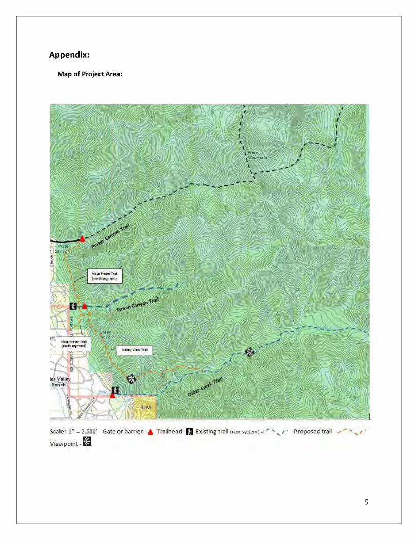
Trail Locations: All of these trails are begin along the boundary of the Town of Star Valley Ranch and the
Bridger-Teton National Forest. See attached map
Why is this proposed?:
1. Improve opportunity for people to connect with nature and public land by providing loop
options for non-motorized use.
2. Improve watershed conditions by reducing illegal activity and repairing unsustainable trails.
3. Increase opportunities for citizen engagement in stewardship of the National Forest.
4. To add recreational opportunities and diversity for residents of the Star Valley and those visiting
from other locations.
Design Elements: The basic design elements in the proposal are as follows:
1. Adopt all three canyon trails to the NF System.
2. Re-construct and provide heavy maintenance to the Cedar Creek Trail.
3. Add two trails which connect all three canyon trails providing for a number of hiking
opportunities including a loop route.
4. Provide a centralized Trailhead that allows for easy access to National Forest lands. All three
canyons could be accessed from this one trailhead, however a second trailhead at the mouth of
Cedar Creek would also be established and maintained.
Public Access/Trailheads: All of these trails will have full public access, not just for the residents of the
Town of Star Valley Ranch but any visitor to the area. The central access point to this trail system would
be the Green Canyon Trailhead. From here a hiker would be able to access any of the three canyons and
associated trails. With the addition of Highway 89 as an official scenic byway through the Star Valley we
would also propose that Wyoming Department of Transportation add directional signing for National
Forest access from Highway 89 to the Green Canyon Trailhead.
A secondary trailhead would eventually be needed at the mouth of Cedar Creek Canyon. At the present
time hikers and horse users are able to access the trail by crossing private land owned by Leisure Valley
Inc. Space does exist on National Forest and Association lands to construct a trailhead and connecting
trail should LVI no longer permit access across their property.
Season of Use: Primary season of use for these trails would be summer and fall. There would however
be some winter use of the Vista Prater Trail, mostly by snowshoers.
Construction and Maintenance: The Town and Association will lead, in conjunction with the Forest
Service, the design, construction and reconstruction of these trails. The Town and Association will apply
for a RTP Grant through the State of Wyoming for funding to include leadership, supplies and tools. The

4
Town and Association will develop a volunteer trail crew to be led by a paid employee. Trail
construction/maintenance and reconstruction will be accomplished through the use of volunteers.
Construction/Reconstruction Schedule: Below is listed a proposed phasing of the
construction/reconstruction and maintenance work. An RTP grant request will be submitted in 2014 for
the first two phases.
Phase 1 (2015): Reconstruct/Maintain the first 3 miles of the Cedar Creek Trail. Construct the 1.1 mile
Vista Green Trail from Vista Drive to Prater Canyon. Establish signing on these trails and an information
kiosk at the Green Canyon Trailhead as well as traffic control barriers and gates.
Phase 2 (2016): Maintain/reconstruct the upper 1.5 miles of the Cedar Creek Trail. Construct the first
1.05 miles of the Valley View Trail from the junction with the Vista Green Trail to the viewpoint above
Cedar Creek Canyon. Maintain/Reconstruct the Green Canyon Trail.
Phase 3 (2017): Establish a Trailhead on NF and Association property at the mouth of Cedar Creek
Canyon. Install information and trail signing. Construct the final 0.80 miles of the Valley View Trail from
the viewpoint above the mouth of Cedar Creek Canyon to the junction with Cedar Creek Trail.
Associated Benefits: Additional benefits will be derived from the establishment of these trails and
facilities.
1. Increased public access to public lands
2. Increased access for fuels management reduction projects, especially along the Vista Prater
Trail.
3. Better access for noxious weed control
4. Better signing and understanding of the National Forest boundary.
5. A safer experience for the forest visitor
6. Increased opportunities for business transactions with increased stops along Highway 89.
5
Appendix:
Map of Project Area:

6
Trail Logs/Photos:
A. Cedar Creek Trail
Cedar Creek Trail is an existing “user trail” that is not on the Forest Service trail system. If begins
at the mouth of Cedar Creek Canyon and extends for approximately 4.5 miles where it
terminates near a small unnamed lake. It rises in elevation from 6,334 feet at the entrance to
the canyon to 8,845 feet at the lake with an average grade of 10.5%.
MP 0.27: Cedar Creek Trail at NF Boundary looking up canyon.
In general the trail has a very good tread although there are a number of locations that require
tread work or trail relocation. By far the primary maintenance need for this trail is brushing and
cutting downfall. In many locations years of downfall has required users to find a new route and
wander around fallen trees.

7
MP 0.50: Good tread condition as trail climbs up Cedar Creek Canyon
In several locations drainage from side seeps and springs either does not drain from the trail or
actually runs down there trail for 20 or 30 feet. Some maintenance will be required, in five or six
locations, to move this water off the trail or construct rock culverts to carry the water under the
trail.
In one location, at MP 0.61 the trail actually follows the creek bed for 50 feet or so and requires
hikers to wade along the stream during the high water season. The best solution here is to
relocate the trail a few feet to the north out of the creek bed and use a small crib wall to protect
the tread.

8
MP 0.55: The first 0.7 miles of the trail follows closely to Cedar Creek
MP 0.61: Trail dips into the creek bed for around 50 feet

9
MP 0.63: Second area along the creek requiring some tread work.
At MP 0.70 the trail begins to climb away from the creek on the south facing slope. Grades
average 10 to 12% with some short steeper pitches. But the tread is good and shows no
erosion.
At MP 0.85 the trail comes to a very nice overlook. From here you get a good view looking back
down the canyon and at the creek below. A very nice cataract is formed as the creek flows over
a large rock outcrop. A short spur trail leads to a nice rock to stand on and gather in the view.

10
MP 0.85: From viewpoint looking down into Cedar Creek
MP 0.85: Lookout Rock

11
At MP 0.96 the trail comes into a very nice grove of White Spruce.
MP 1.24: Brushing is the big maintenance issue

12
At MP 1.45 the trail begins a steep climb, 18 to 20% grade up the south facing slope of the
canyon. At MP 1.64 the trail levels out at 7,351 ft., 1,000 feet above the mouth of the canyon.
From here there are excellent views of the Star Valley to the west and to the east a large basin
that the trail now enters. The main maintenance issue here is downed logs.
MP 1.64: Looking west into the Star Valley and the Caribou Mountains of Idaho
MP 1.85: Lots of downfall from here on.

13
At MP 2.10 the trail crosses a side creek and enters a long, relatively flat basin. Meadows with
wildflowers are surrounded by stands of spruce and fir with very little mortality. For the next
mile the trail rises at a 4 to 5% grade.
MP 2.45: Looking north from trail in a large basin at 7,600 feet, almost 1,300 feet above the mouth of the canyon.
At MP 3.12 the trail starts a steep climb to the unnamed lake.

14
B. Green Canyon Trail
Green Canyon Trail is actually a 1.27 mile, 4-wheel drive road that starts at the mouth of Green
Canyon and terminates at the intersection of two canyon drainages. This road is used by the
Star Valley Ranch Association and Leisure Valley Inc. to maintain access to water collection
facilities in the canyon. The trail is currently used by hikers, bikers and ATV users. It is very
steep, rising 913 feet in a little over a mile and a quarter; this works out to a 14% grade.
MP 0.1: Beginning of trail just above parking area.
MP 1.27: End of trail where two drainages come together and form Green Canyon Creek.

15
C. Prater Canyon Trail
Prater Canyon Trail begins at the end of a 0.86 mile road that is maintained by the Town of Star
Valley Ranch to assess their water collection facilities in the canyon. At the end of the road
there is a small parking area at 7,342 ft. From here the Prater Canyon Trail follows the creek
heading east to Murphy Canyon and Murphy Lakes. This is a NF System trail.
MP 0.2: Prater Canyon Trail looking west towards the Star Valley.

16
MP 0.45: The Prater Canyon Trail is extremely steep with an average grade of 30%
This proposal would provide some trail maintenance within the Prater Canyon watershed.
D. Vista Prater Trail
The Vista Prater Trail is a proposed trail that would run from Vista Ave. in the Town of Star
Valley Ranch on the south to Prater Canyon Road on the north. It would be approximately 1.10
miles in length and rise 450 feet from south to north; a 7.6% grade. Construction would not be
difficult as it is rolling terrain and it follows a shaded fuel break on National Forest land.
The trail has been located near the toe of the slope as far east as possible. This places the trail
out of sight from the homes that have been built along the NF boundary. This trail should be
quite popular with hikers on the ranch as it could be combined with other trails and roads to
make some nice loop opportunities.

17
View from Vista Drive looking north. Typical terrain and vegetation.
E. Valley View Trail
The proposed Valley View Trail begins from the Vista Prater Trail approximately 0.15 miles south
of Green Canyon and the proposed trailhead. From this junction the route of the trail heads
southeast and begins to climb the face of the slope between Green Canyon and Cedar Canyon.
The trail will quickly climb to get above the tree line and screen the trail from the homes along
the Forest Boundary.
The trail has been designed to follow a forested, natural bench along the face of the slope so
that the trail is not visible from the valley below. Hikers will experience secluded forest walk
with a brief view of the valley as they move south. When they reach the ridge above the mouth
of Cedar Creek Canyon they will be treated to a panoramic view of both the Upper and Lower
Star Valleys and the Caribou Mountain in Idaho.
The trail from Green Canyon to the Cedar Creek Viewpoint is 1.05 miles in length. Total
elevation gained over this run is 545 feet; an average of a 9.8% grade. At the viewpoint the
elevation is 7,109 feet, approximately 775 feet above the entrance to Cedar Creek Canyon.

18
Valley View Trail as viewed from Cedar Creek Road.
MP: 0.0: Valley View Trail route heading southeast to the toe of the slope

19
MP: 0.15: Typical vegetation and side slope.
MP 0.35: First of four small ravines all of which can be easily crossed.

20
MP 0.63: Trail stays within the vegetation on the bench. Hiker gets an occasional view of the valley.
MP 1.05: Panoramic Viewpoint above the mouth of Cedar Creek Canyon, looking southwest.

21
Another view looking west.
MP 1.12: View looking up Cedar Creek. Trail will extend from here up Cedar Creek Canyon and join Cedar Creek Trail at MP 1. 05, just above
the White Spruce Grove.

22
Summary: The proposed addition of two existing trails within the Bridger-Teton National Forest to the
National Forest Trails System, the improvement of one trail which is already on the National Forest Trails
System and the construction of two new trails within this forest area will greatly improve public access
to the National Forest. This proposed partnership with the Bridger-Teton National Forest will allow the
Town of Star Valley Ranch and the Star Valley Ranch Association to implement these changes using
funds provided by a proposed Recreational Trails Program (RTP) grant from the State of Wyoming and
volunteers provided by the Town of Star Valley Ranch and/or the Star Valley Ranch Association.