townson road subdivision application
TRANSCRIPT
1
!
! ii
Townson Road Subdivision Application Statement of Environmental Effects On behalf of Luxeland Development Pty Ltd September 2017
2
Project Director
Contributors
Michael Hanisch
Revision Revision Date Status Authorised
Name Signature
1 August 2017 Draft MH
2 September Final AC
* This document is for discussion purposes only unless signed and dated by the persons identified. This document has been reviewed by the Project Director.
Contact
Mecone
Suite 1204b, Level 12, 179 Elizabeth Street Sydney, New South Wales 2000
[email protected] mecone.com.au
© Mecone
All Rights Reserved. No part of this document may be reproduced, transmitted, stored in a retrieval system, or translated into any language in any form by any means without the written permission of Mecone.
All Rights Reserved. All methods, processes, commercial proposals and other contents described in this document are the confidential intellectual property of Mecone and may not be used or disclosed to any party without the written permission of Mecone.
3
Table of Contents
1 General Information .................................................................................... 51.1 Proposed Development ............................................................................... 51.2 Environmental Assessment ........................................................................... 51.3 Site suitability .................................................................................................. 61.4 Public Interest ................................................................................................. 61.5 Proponent and Project Team ...................................................................... 71.6 Background ................................................................................................... 7
1.6.1 Planning Proposal – Part Precinct Release ................................................. 71.6.2 Development Consent for Staged Residential Subdivision ...................... 8
1.7 Pre-DA Meeting ............................................................................................. 9
2 The Site ........................................................................................................ 152.1 Regional Context ........................................................................................ 152.2 Local Context .............................................................................................. 162.3 Site Description ............................................................................................ 16
3 The Proposal ............................................................................................... 183.1 Development Summary .............................................................................. 183.2 Residential Lots ............................................................................................ 193.3 Road Layout ................................................................................................. 193.4 Landscaping ................................................................................................ 243.5 Civil works ..................................................................................................... 24
4 Planning and Environmental Assessment ................................................ 254.1 Planning Assessment ................................................................................... 25
4.1.1 Integrated Assessment ............................................................................... 254.1.2 State Environmental Planning Policies (SEPPs) ......................................... 264.1.2.1 SEPP No. 55 – Remediation of Land .......................................................... 264.1.2.2 SEPP (Infrastructure) 2007 ........................................................................... 274.1.2.3 SEPP (Sydney Region Growth Centres) 2006 ........................................... 274.1.3 Development Control Plans (DCPs) .......................................................... 344.1.3.1 Key DCP Issues ............................................................................................ 344.1.4 Other Planning Matters ............................................................................... 384.1.4.1 Voluntary Planning Agreement ................................................................ 384.1.4.2 Land Use and Infrastructure Implementation Plan – North West Priority Growth Area ................................................................................................ 39
4
4.2 Environmental Assessment ......................................................................... 394.2.1 Flora and Fauna Assessment ..................................................................... 394.2.2 Bushfire .......................................................................................................... 404.2.3 Stormwater Management and Erosion Control ...................................... 414.2.4 Archaeological Heritage ........................................................................... 424.2.5 Traffic ............................................................................................................ 42
5 Section 79C Assessment ............................................................................ 43
6 Conclusion .................................................................................................. 45
7 Appendices ................................................................................................ 487.1 Appendix 1 – Cost of Works ....................................................................... 487.2 Appendix 2 – Proposal Plans ...................................................................... 497.3 Appendix 3 – Biocertification Letter .......................................................... 507.4 Appendix 4 – Contamination and Geotechnical Report ...................... 517.5 Appendix 5 – Traffic Report ........................................................................ 527.6 Appendix 6 – Bushfire Assessment ............................................................. 537.7 Appendix 7 – Archaeological Report ....................................................... 547.8 Appendix 8 – Civil Engineering Report ...................................................... 557.9 Landscaping Plans ...................................................................................... 567.10 Blacktown Growth Centres DCP Assessment .......................................... 577.11 Service Confirmation Letters ...................................................................... 587.12 Vegetation Management Plan ................................................................. 59
Schedule of Tables
Table 1 – Project Team ............................................................................................................ 7Table 2 – Pre-Application Meeting Response ....................................................................... 9Table 3 – Site Description ....................................................................................................... 16Table 4 – SEPP (Sydney Region Growth Centres) 2006 – Appendix 12 ............................ 28Table 5 – BEP assessment against Table 4-2 of the DCP .................................................... 34Table 6 – BEP assessment against Table 4-4 of the DCP .................................................... 36Table 7 – Section 79C Assessment Summary ...................................................................... 43
5
1 General Information This Statement of Environmental Effects (SEE) report has been prepared on behalf of Luxeland Development Pty Ltd (Luxeland) to support a Development Application (DA) to Blacktown City Council (Council) for a residential subdivision at Townson Road, Colebee.
The subject DA follows the rezoning of the site as part of a “part of precinct release” in the North West Priority Growth Area, known as the West Schofields (Townson Road) Precinct. The rezoning was gazette in June 2016 and resulted in the site being zoned for a mix of land uses including residential, recreational, infrastructure and for environmental protection.
The proposed subdivision subject of this DA is over the balance of the West Schofields (Townson Road) Precinct, not subject of Consent DA-6-04442. Consent DA-16-04442 was issued on 16 June 2017 over land at Lot 567 DP1200170, Alderton Drive for;
Stage subdivision of Lot 567 DP1200170 into 283 Torrens Title Lots, Building Envelope Plans and three (3) lots zoned SP2 (lot 285), RE1 (Lot 284) and E2 (Lot 286), with associated works including Bulk Earthworks and Tree Removal Construction of Public Roads, Stormwater Drainage, Landscaping, Street Tree Planting and Temporary on site detention basin.
The proposal subject of this application is located over the land north of Consent DA-16-04442. The subject site is defined as Lot 1029 DP1191446 and Lots 5-8 DP27536, Townson Road, Colebee.
The SEE includes an assessment of the proposed works in terms of the matters for consideration as listed under Section 79C of the Environmental Planning and Assessment Act 1979 (EPAA) and should be read in conjunction with information annexed to this report. Specifically, the SEE includes the following information:
• Description of the site in its local and regional context; • Identification of the proposed works; • Assessment of the project against Council’s controls and policies; • Assessment of all environmental impacts of the project; and • Identification of measures for minimising or managing the potential
environmental impacts.
1.1 Proposed Development The application includes a Torrens Title subdivision of the site and includes;
§ Land clearing and bulk earthworks to make the site suitable for the residential development;
§ 213 x residential Allotments; § 3 x residual allotments; § 1 x drainage allotment; § 1 x parkland allotment; § Associated Civil works including;
o servicing, public roads, stormwater drainage. § Street landscaping.
6
1.2 Environmental Assessment
This Statement of Environmental Effects in conjunction with the other documents submitted with the application provides an environmental assessment of the proposal. It was found that the associated impacts are considered to be minimal and manageable. Hence, the outcomes of the proposed development include but are not necessarily limited to:
§ Integrating the development with the approved lot layout within DA-16-04442;
§ The staged development of 213 x residential allotments with a mix of size and orientation, suitable for future dwellings;
§ Providing 2 x allotments for dedication to Council for the purposes of public recreation and public infrastructure (drainage);
§ Construction of public roads that provide a logical layout that orientates the subdivision to take advantage of site features;
§ Create residual lots that provide opportunity development opposite land designated RE1 Public Recreation;
§ Creation of rear access lanes to allotments; and
§ Provision of public landscaping and infrastructure.
MBM Quantity Surveyors have calculated the cost of development for the proposal to be $11,837,370.60 (including GST). Refer to Appendix 1 for the Cost Estimate of the proposed.
An environmental and planning assessment of the proposal is provided in Section 4 of this report.
1.3 Site suitability
The proposal is considered to be suitable for the site for the following reasons:
§ The proposed development is consistent with the land use designation for the site in the West Schofields (Townson Road) Precinct of the North West Priority Growth Area.
§ The proposal will not adversely impact on any adjoining land and provides the logical development of the site for residential purposes.
§ The proposal does not adversely impact on environmental attributes or features of the land or increase the risk of natural hazards that may affect the land.
1.4 Public Interest
The proposal is considered to be in the public interest for the following reasons:
§ The proposal will have minimal environmental impacts.
§ The proposal provides a suitable and diverse housing product that integrates with adjoining land uses.
§ The development includes provision of suitable infrastructure to service the residential development to a suitable standard.
7
§ Provision of suitable streetscape amenity by providing open space and streetscape landscaping.
Therefore, it is considered that the proposal is within the public interest, based on the above outcomes and a high quality outcome for the site and the Blacktown City Council Local Government Area (LGA).
1.5 Proponent and Project Team
The Development Application and SEE Report have been prepared on behalf of the applicant, Luxeland Development Pty Ltd.
Table 1 – Project Team
Item Description
Urban Planning Assessment Mecone
Architectural and Landscape Design Cox Architecture
Cost of Works MBM Quantity Surveyors
Engineering Northrop
Bushfire and Vegetation Management Consultant EcoLogical
Archaelogical Heritage Kelleher Nightingale Consulting Pty Ltd
Contamination Douglas Parnters
Landcaping Site Image
Traffic Traffix
1.6 Background
1.6.1 Planning Proposal – Part Precinct Release
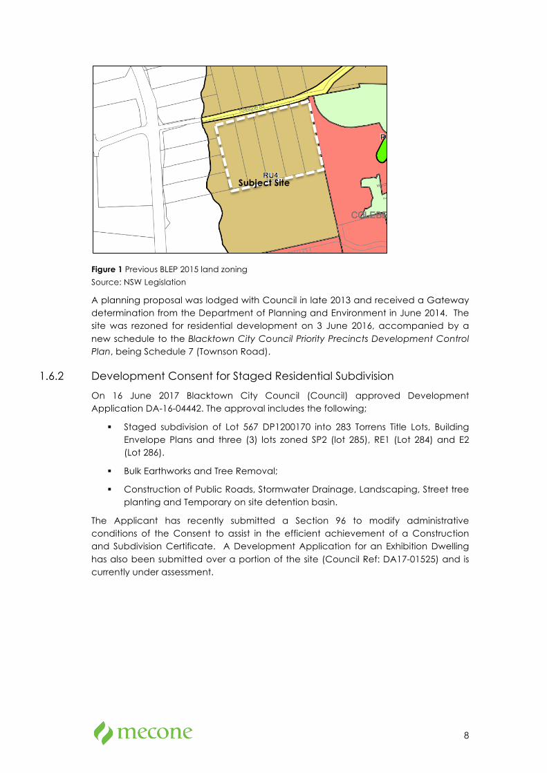
The subject was rezoned in June 2016 under a part-precinct release of the West Schofields Precinct in the North West Priority Growth Area. Prior to this, the site was zoned RU4 – Primary Production Small Lots under the Blacktown Local Environmental Plan (BLEP) 2015, as shown in the figure below.
8
Figure 1 Previous BLEP 2015 land zoning
Source: NSW Legislation
A planning proposal was lodged with Council in late 2013 and received a Gateway determination from the Department of Planning and Environment in June 2014. The site was rezoned for residential development on 3 June 2016, accompanied by a new schedule to the Blacktown City Council Priority Precincts Development Control Plan, being Schedule 7 (Townson Road).
1.6.2 Development Consent for Staged Residential Subdivision
On 16 June 2017 Blacktown City Council (Council) approved Development Application DA-16-04442. The approval includes the following;
§ Staged subdivision of Lot 567 DP1200170 into 283 Torrens Title Lots, Building Envelope Plans and three (3) lots zoned SP2 (lot 285), RE1 (Lot 284) and E2 (Lot 286).
§ Bulk Earthworks and Tree Removal;
§ Construction of Public Roads, Stormwater Drainage, Landscaping, Street tree planting and Temporary on site detention basin.
The Applicant has recently submitted a Section 96 to modify administrative conditions of the Consent to assist in the efficient achievement of a Construction and Subdivision Certificate. A Development Application for an Exhibition Dwelling has also been submitted over a portion of the site (Council Ref: DA17-01525) and is currently under assessment.
Subject Site
9
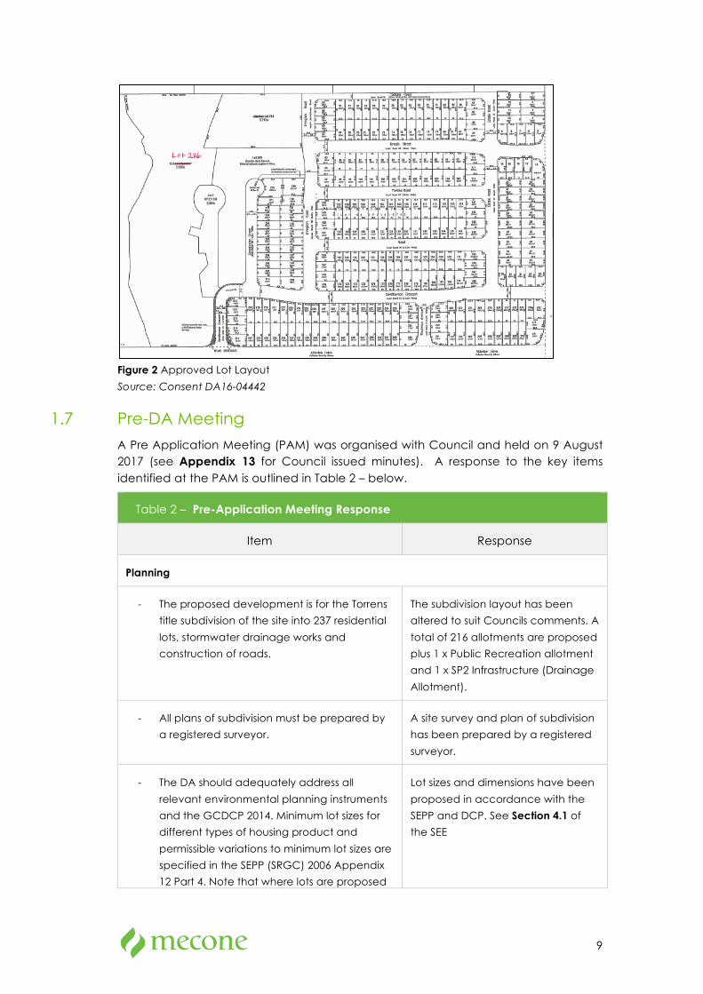
Figure 2 Approved Lot Layout
Source: Consent DA16-04442
1.7 Pre-DA Meeting
A Pre Application Meeting (PAM) was organised with Council and held on 9 August 2017 (see Appendix 13 for Council issued minutes). A response to the key items identified at the PAM is outlined in Table 2 – below.
Table 2 – Pre-Application Meeting Response
Item Response
Planning
- The proposed development is for the Torrens
title subdivision of the site into 237 residential
lots, stormwater drainage works and
construction of roads.
The subdivision layout has been
altered to suit Councils comments. A
total of 216 allotments are proposed
plus 1 x Public Recreation allotment
and 1 x SP2 Infrastructure (Drainage
Allotment).
- All plans of subdivision must be prepared by
a registered surveyor.
A site survey and plan of subdivision
has been prepared by a registered
surveyor.
- The DA should adequately address all
relevant environmental planning instruments
and the GCDCP 2014. Minimum lot sizes for
different types of housing product and
permissible variations to minimum lot sizes are
specified in the SEPP (SRGC) 2006 Appendix
12 Part 4. Note that where lots are proposed
Lot sizes and dimensions have been
proposed in accordance with the
SEPP and DCP. See Section 4.1 of
the SEE
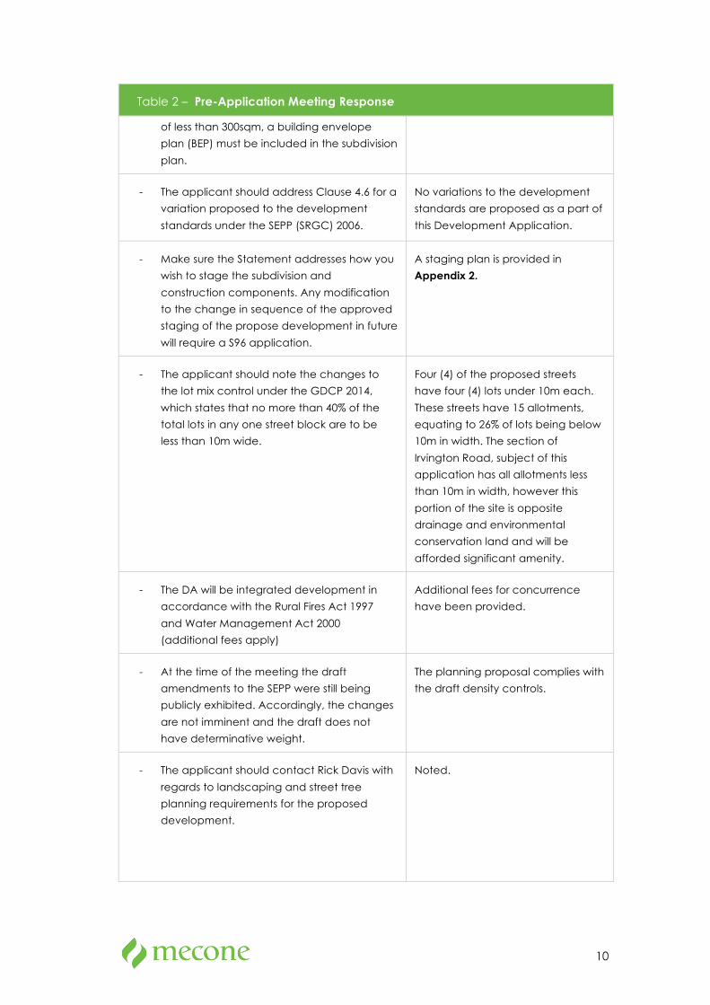
10
Table 2 – Pre-Application Meeting Response
of less than 300sqm, a building envelope
plan (BEP) must be included in the subdivision
plan.
- The applicant should address Clause 4.6 for a
variation proposed to the development
standards under the SEPP (SRGC) 2006.
No variations to the development
standards are proposed as a part of
this Development Application.
- Make sure the Statement addresses how you
wish to stage the subdivision and
construction components. Any modification
to the change in sequence of the approved
staging of the propose development in future
will require a S96 application.
A staging plan is provided in
Appendix 2.
- The applicant should note the changes to
the lot mix control under the GDCP 2014,
which states that no more than 40% of the
total lots in any one street block are to be
less than 10m wide.
Four (4) of the proposed streets
have four (4) lots under 10m each.
These streets have 15 allotments,
equating to 26% of lots being below
10m in width. The section of
Irvington Road, subject of this
application has all allotments less
than 10m in width, however this
portion of the site is opposite
drainage and environmental
conservation land and will be
afforded significant amenity.
- The DA will be integrated development in
accordance with the Rural Fires Act 1997
and Water Management Act 2000
(additional fees apply)
Additional fees for concurrence
have been provided.
- At the time of the meeting the draft
amendments to the SEPP were still being
publicly exhibited. Accordingly, the changes
are not imminent and the draft does not
have determinative weight.
The planning proposal complies with
the draft density controls.
- The applicant should contact Rick Davis with
regards to landscaping and street tree
planning requirements for the proposed
development.
Noted.

11
Table 2 – Pre-Application Meeting Response
Engineering
- The applicant is proposed a variation to the
ILP road pattern. Council’s Senior Traffic
Management Officer indicated that the
internal road layout of the proposed
subdivision plan tabled at the meeting is
considered satisfactory and likely to be
supported.
Noted – the road layout has not
changed since the PAM.
- All laneways are to be community titled
unless RMS agree to signpost for a shared
zone. For community titled roads, a minimum
7m width with 1.5m wide footpath on one
side is required.
Laneways are proposed in a
community title arrangement and
are designed in accordance with
Council’s DCP.
- Note that Australian Standard require that
where a laneway connects with a subdivision
road, the laneway entry point cannot be
within 6m of the tangent point of a
subdivision road intersection.
Laneway access is in excess of 6m
from any intersection.
- The DA is to demonstrate that access and
turning paths comply with Australian
Standards, in particular within proposed
driveways and laneways.
All access and turning paths comply
with Australian Standard. Where
there is any concern, the Traffic
Report in Appendix 5 has provided
swept paths.
- The applicant proposed a reduction in road
width directly adjoining land zoned RE1
Public Recreation. Council’s Engineer Design
(Tony Merrilees) indicated that Council would
not support any reduction in RE1 Public
Reservation and SP2 Infrastructure classified
roads as it will lead to road inconsistencies.
No reduction in road width has
been proposed.
- Footpath is still required along the RE1 zoned
site as the final path of the cycleway through
the E2 zoned land is not yet set.
The applicant is currently liaising with
Councils recreation department to
design the RE1 zoned land, which
will provide the cycleway.
- The applicant enquired of the requirements
for footpath of the shared cycling path under
the VPA going through the RE1 lane. Tony
Merrilees stated that there is also an option of
it going through E2 zoned land.
The E2 land will be under private
ownership tied to proposed Lot 214.
No public walkway will be provided.
- Council’s Engineer – Design noted that the E2
lot identified on the plans tabled at the
The E2 land will be tied to proposed
Lot 214. The relevant mechanism will
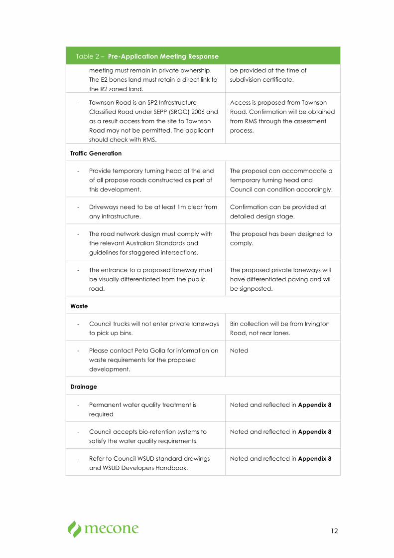
12
Table 2 – Pre-Application Meeting Response
meeting must remain in private ownership.
The E2 bones land must retain a direct link to
the R2 zoned land.
be provided at the time of
subdivision certificate.
- Townson Road is an SP2 Infrastructure
Classified Road under SEPP (SRGC) 2006 and
as a result access from the site to Townson
Road may not be permitted. The applicant
should check with RMS.
Access is proposed from Townson
Road. Confirmation will be obtained
from RMS through the assessment
process.
Traffic Generation
- Provide temporary turning head at the end
of all propose roads constructed as part of
this development.
The proposal can accommodate a
temporary turning head and
Council can condition accordingly.
- Driveways need to be at least 1m clear from
any infrastructure.
Confirmation can be provided at
detailed design stage.
- The road network design must comply with
the relevant Australian Standards and
guidelines for staggered intersections.
The proposal has been designed to
comply.
- The entrance to a proposed laneway must
be visually differentiated from the public
road.
The proposed private laneways will
have differentiated paving and will
be signposted.
Waste
- Council trucks will not enter private laneways
to pick up bins.
Bin collection will be from Irvington
Road, not rear lanes.
- Please contact Peta Golla for information on
waste requirements for the proposed
development.
Noted
Drainage
- Permanent water quality treatment is
required
Noted and reflected in Appendix 8
- Council accepts bio-retention systems to
satisfy the water quality requirements.
Noted and reflected in Appendix 8
- Refer to Council WSUD standard drawings
and WSUD Developers Handbook.
Noted and reflected in Appendix 8

13
Table 2 – Pre-Application Meeting Response
- MUSIC is to be used to assess the
performance of the water quality systems
and an electronic copy provided to Council
for assessment.
Noted and reflected in Appendix 8
- Refer to section 4.2 of Part J of the DCP 2015
for load reduction requirements.
Noted and reflected in Appendix 8
On site detention
- Permanent on site detention is required for
the site area covered by the proposed
development.
Noted and reflected in Appendix 8
- A civil engineer registered with NER is to
certify that the on site detention basin has
been designed to mitigate all post
developed flows from the site to not exceed
pre-developed rural catchment flows for all
storm events from 1 in 2 year ARI to 1 in 100
year ARI. The pre-developed initial pervious
loss is 15mm, compared to post-developed
pervious loss of 5mm at 85% impervious.
Provide a separate pre-developed DRAINS or
RAFTS model. The bioretention extended
detention depth is to be considered as dead
storage or ignored in the model. This design is
to be supported by electronic modeling that
complies with the requirements of Council’s
Engineering Guide for Development 2005
and account for any bypass of the detention
basin along the roads or elsewhere that
cannot drain to the basin. The 12D drainage
program is not approved as an acceptable
model in Blacktown.
Alternatively, design and construct the On
Site Detention System so as to comply, as a
minimum with the requirements of Council’s
WSUD standard drawings and OSD Deemed
to Comply Tool.
Noted and reflected in Appendix 8

14
Table 2 – Pre-Application Meeting Response
Water Conservation
- In developing the MUSIC model allow for
each dwelling to have a 2KL rainwater tank
collecting runoff from a maximum of 50% of
the roof area.
Noted and reflected in Appendix 8
- Submit a copy of the engineering checklist
available from Council website.
Noted and reflected in Appendix 8
- Submit Council MUSIC models for further
assessment.
Noted and reflected in Appendix 8
15
2 The Site
2.1 Regional Context
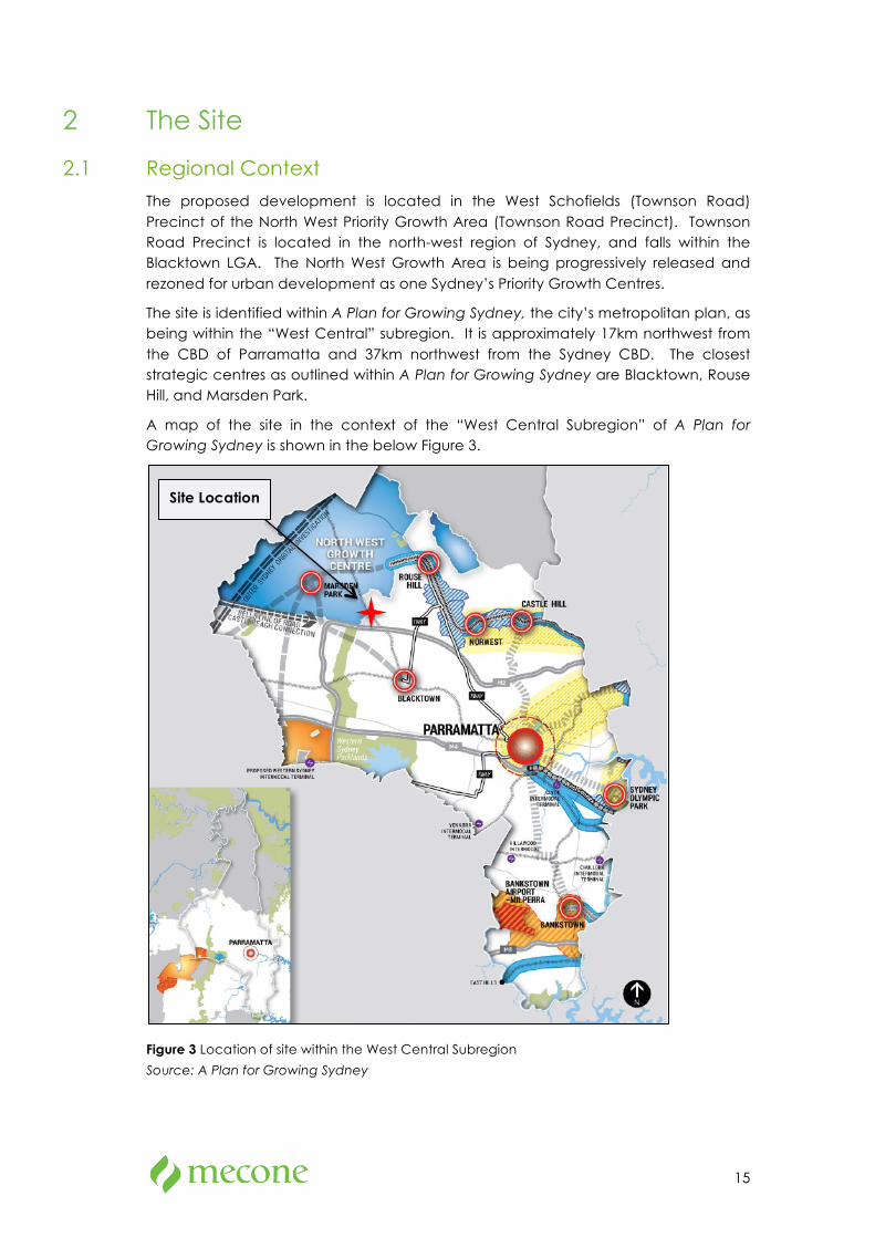
The proposed development is located in the West Schofields (Townson Road) Precinct of the North West Priority Growth Area (Townson Road Precinct). Townson Road Precinct is located in the north-west region of Sydney, and falls within the Blacktown LGA. The North West Growth Area is being progressively released and rezoned for urban development as one Sydney’s Priority Growth Centres.
The site is identified within A Plan for Growing Sydney, the city’s metropolitan plan, as being within the “West Central” subregion. It is approximately 17km northwest from the CBD of Parramatta and 37km northwest from the Sydney CBD. The closest strategic centres as outlined within A Plan for Growing Sydney are Blacktown, Rouse Hill, and Marsden Park.
A map of the site in the context of the “West Central Subregion” of A Plan for Growing Sydney is shown in the below Figure 3.
Figure 3 Location of site within the West Central Subregion
Source: A Plan for Growing Sydney
Site Location
16
2.2 Local Context
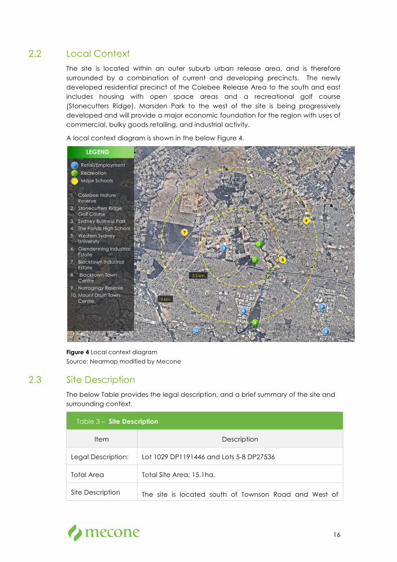
The site is located within an outer suburb urban release area, and is therefore surrounded by a combination of current and developing precincts. The newly developed residential precinct of the Colebee Release Area to the south and east includes housing with open space areas and a recreational golf course (Stonecutters Ridge). Marsden Park to the west of the site is being progressively developed and will provide a major economic foundation for the region with uses of commercial, bulky goods retailing, and industrial activity.
A local context diagram is shown in the below Figure 4.
Figure 4 Local context diagram
Source: Nearmap modified by Mecone
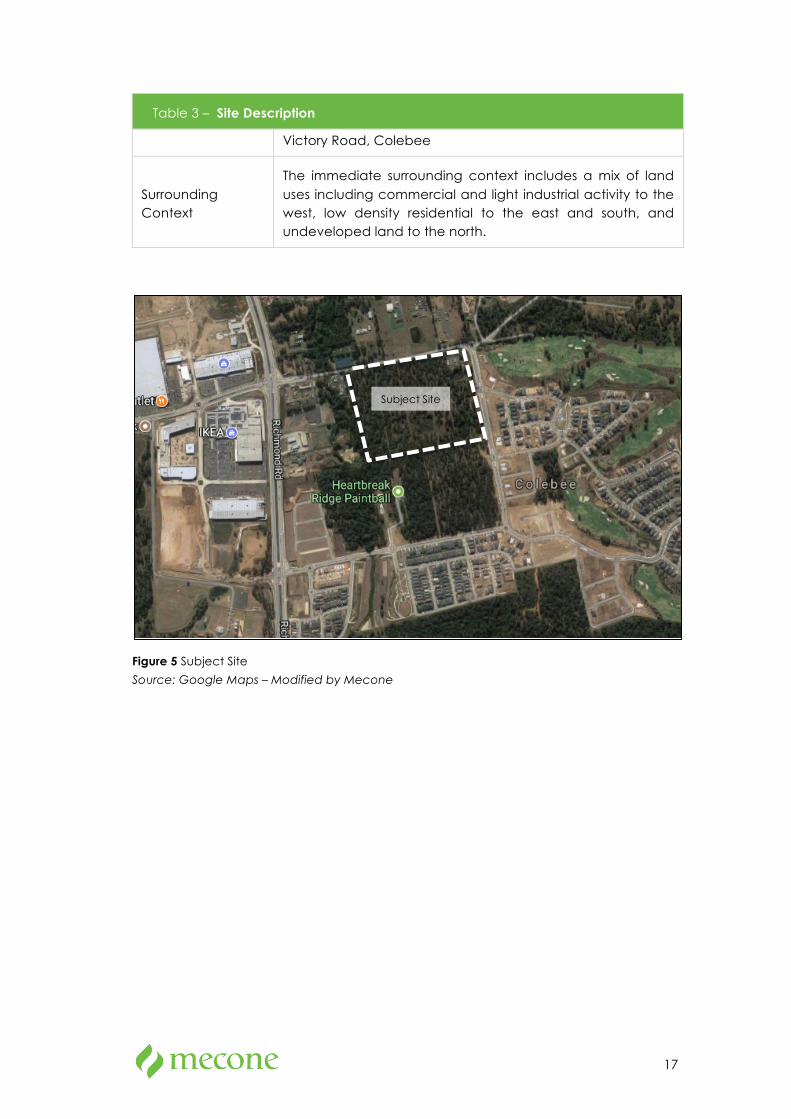
2.3 Site Description
The below Table provides the legal description, and a brief summary of the site and surrounding context.
Table 3 – Site Description
Item Description
Legal Description: Lot 1029 DP1191446 and Lots 5-8 DP27536
Total Area Total Site Area; 15.1ha.
Site Description The site is located south of Townson Road and West of
!
5 km
2.5 km
LEGEND
Retail/Employment
Recreation
Major Schools
1. Colebee Nature Reserve
2. Stonecutters Ridge Golf Course
3. Sydney Business Park
4. The Ponds High School
5. Western Sydney University
6. Glendenning Industrial Estate
7. Blacktown Industrial Estate
8. Blacktown Town Centre
9. Nurragingy Reserve
10. Mount Druitt Town Centre
1
7 !
3 !
2
4 !
5 !
6 !
!
!
7 !
8 !
9 10 !
17
Table 3 – Site Description
Victory Road, Colebee
Surrounding Context
The immediate surrounding context includes a mix of land uses including commercial and light industrial activity to the west, low density residential to the east and south, and undeveloped land to the north.
Figure 5 Subject Site
Source: Google Maps – Modified by Mecone
Subject Site
18
3 The Proposal
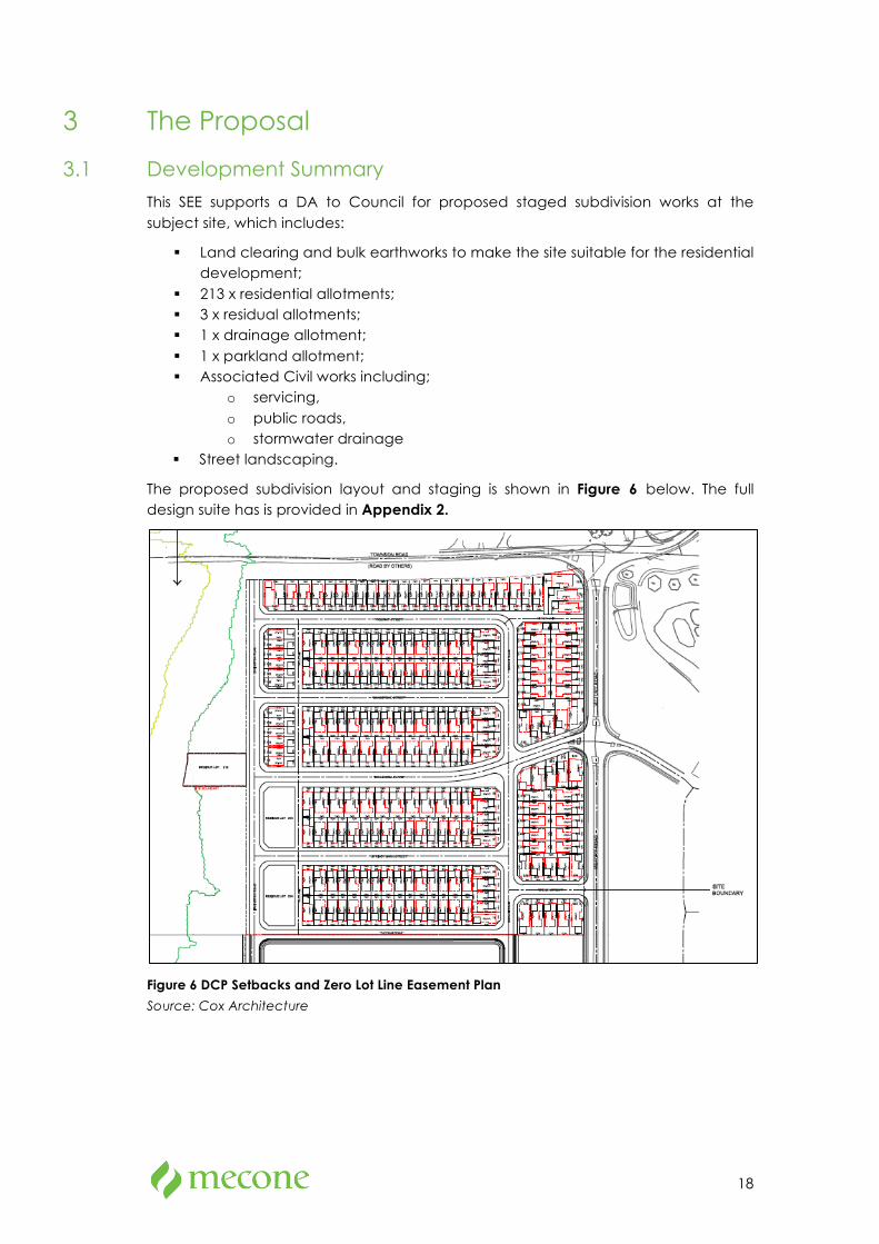
3.1 Development Summary
This SEE supports a DA to Council for proposed staged subdivision works at the subject site, which includes:
§ Land clearing and bulk earthworks to make the site suitable for the residential development;
§ 213 x residential allotments; § 3 x residual allotments; § 1 x drainage allotment; § 1 x parkland allotment; § Associated Civil works including;
o servicing, o public roads, o stormwater drainage
§ Street landscaping.
The proposed subdivision layout and staging is shown in Figure 6 below. The full design suite has is provided in Appendix 2.
Figure 6 DCP Setbacks and Zero Lot Line Easement Plan
Source: Cox Architecture

19
3.2 Residential Lots
The proposal provides for a total of 213 residential allotments, which consist of;
§ 4 x allotments above 500m2 in area; § 103 x allotments between 300m2 and 500m2; § 106 x allotments 250m2 to 300m2 in area
Of these allotments 36 are afforded a width of 9m. A total of 105 allotments have a width in excess of 12m.
Residue allotments 214-216 are either adjoining or opposite parkland and have the following site areas;
§ Lot 214 – 1,665.8m2 § Lot 215 – 1,599m2 § Lot 216 – 1,599m2
The applicant intends to construct the resultant dwellings and has therefore considered suitable lot configurations that will provide a diverse dwelling typology. The lot layout demonstrates that a range of alternative building types can be provided.
Figure 7 Proposed Building Envelope Site Plan
Source: Cox Architecture
3.3 Road Layout
The proposed road layout provides the framework for the subdivision. The road layout has been derived from existing site features and ensures the layout provides the best amenity for the future residents, respects the existing environment, fosters a