tracking dinosaurs in blm canyon country, utah · three-day field trip will visit many important...
TRANSCRIPT

GEOLOGY OF THE INTERMOUNTAIN WESTan open-access journal of the Utah Geological Association
Volume 3 2016
© 2016 Utah Geological Association. All rights reserved. For permission to copy and distribute, see the following page or visit the UGA website at www.utahgeology.org for information.Email inquiries to [email protected].
TRACKING DINOSAURS IN BLM CANYON COUNTRY, UTAH
ReBecca K. Hunt-Foster, Martin G. Lockley, Andrew R.C. Milner, John R. Foster, Neffra A. Matthews, Brent H. Breithaupt, and Joshua A. Smith
A Field Guide Prepared ForSOCIETY OF VERTEBRATE PALEONTOLOGY
Annual Meeting, October 26 – 29, 2016Grand America Hotel
Salt Lake City, Utah, USA

GEOLOGY OF THE INTERMOUNTAIN WESTan open-access journal of the Utah Geological Association
ProductionCover Design and Desktop Publishing
Douglas A. Sprinkel
CoverA Navajo Sandstone scene from 185 million years ago. A variety of vertebrates stroll and swim near an inter-dunal lake “oasis” while small animals take refuge in their burrows and pterosaurs fly overhead. Artwork by Brian Engh, dontmesswithdinosaurs.com.
i
2016 President Bill Loughlin [email protected] 435.649.40052016 President-Elect Paul Inkenbrandt [email protected] 801.537.33612016 Program Chair Andrew Rupke [email protected] 801.537.33662016 Treasurer Robert Ressetar [email protected] 801.949.33122016 Secretary Tom Nicolaysen [email protected] 801.538.53602016 Past-President Jason Blake [email protected] 435.658.3423
UGA Board
UGA CommitteesEducation/Scholarship Loren Morton [email protected] 801.536.4262Environmental Affairs Craig Eaton [email protected] 801.633.9396Geologic Road Sign Terry Massoth [email protected] 801.541.6258Historian Paul Anderson [email protected] 801.364.6613Membership Rick Ford [email protected] 801.626.6942 Public Education Paul Jewell [email protected] 801.581.6636 Matt Affolter [email protected] Publications Roger Bon [email protected] 801.942.0533Publicity Paul Inkenbrandt [email protected] 801.537.3361Social/Recreation Roger Bon [email protected] 801.942.0533
AAPG House of Delegates2016-2018 Term Craig Morgan [email protected] 801.422.3761
State Mapping Advisory CommitteUGA Representative Jason Blake [email protected] 435.658.3423
UGA NewsletterNewsletter Editor Bob Biek [email protected] 801.537.3356
UGA Websitewww.utahgeology.org
Webmasters Paul Inkenbrandt [email protected] 801.537.3361 Lance Weaver [email protected] 801.403.1636
Become a member of the UGA to help support the work of the Association and receive notices for monthly meetings, annual field conferences, and new publi-cations. Annual membership is $20 and annual student membership is only $5. Visit the UGA website at www.utahgeology.org for information and membership application.
The UGA board is elected annually by a voting process through UGA Members. However, the UGA is a volunteer driven organization, and we welcome your voluntary service. If you would like to participate please contact the current president or committee member corresponding with the area in which you would like to volunteer.
Utah Geological Association formed in 1970 from a merger of the Utah Geological Society, founded in 1946, and the Intermountain Association of Geologists, founded in 1949. Affiliated with the American Association of Petroleum Geologists.
Volume 3 2016
This is an open-access article in which the Utah Geological Association permits unrestricted use, distribution, and reproduction of text and figures that are not noted as copyrighted, provided the original author and source are credited.
Earthquake Safety CommitteChair Grant Willis [email protected] 801.537.3355
Douglas A. SprinkelUtah Geological Survey
Bart J. KowallisBrigham Young University
Thomas C. Chidsey, Jr.Utah Geological Survey
Steven SchamelGeoX Consulting, Inc.
Society of Vertebrate PaleontologyEditors
James I. Kirkland (Editor-in-Chief) — Utah Geological Survey ReBecca Hunt-Foster — Bureau of Land Management
Greg McDonald — Bureau of Land ManagementMartha Hayden — Utah Geological Survey
Editors
GEOLOGY OF THE INTERMOUNTAIN WESTan open-access journal of the Utah Geological Association
Volume 3 2016
67
ABSTRACTThe remarkably extensive and abundant Mesozoic-aged exposures on public lands around Moab have
made this region well known for ichnofossils. The nearly complete record of Upper Triassic through Low-er Cretaceous rocks exposed in this area is well known for its sheer abundance of tracks and traces. This three-day field trip will visit many important classic and new sites exposed in the Bureau of Land Manage-ment’s Canyon Country District. This field trip guidebook will give one an overview of the major sites we will visit, as well as a brief summary of work previously done in these areas.
Tracking Dinosaurs in BLM Canyon Country, Utah
ReBecca K. Hunt-Foster1, Martin G. Lockley2, Andrew R.C. Milner3, John R. Foster4, Neffra A. Matthews5, Brent H. Breithaupt6, and Joshua A. Smith7
1Bureau of Land Management – Canyon Country District, 82 East Dogwood, Moab, Utah 84532; [email protected] of Colorado Denver, Campus Box 172, University of Colorado Denver, PO Box 173364, Denver, Colorado 80217; [email protected]. George Dinosaur Discovery Site at Johnson Farm, 2180 East Riverside Drive, St. George, Utah 84790; [email protected] of Moab, 118 East Center Street, Moab, Utah 84532; [email protected] of Land Management National Operations Center, Geospatial Section, Denver Federal Center, Bldg. 50, P.O. Box 25047, OC-534, Denver, Colorado 80225-0047; [email protected] of Land Management, 5353 Yellowstone Road, Cheyenne, Wyoming 82009; [email protected] Anthropological Research Group (DARG), P.O. Box 3543, Grand Junction, Colorado 81502; [email protected]
Citation for this article.Hunt-Foster, R.K., Lockley, M.G., Milner, A.R.C., Foster, J.R., Matthews, N.A., Breithaupt, B.H., and Smith, J.A., 2016, Tracking dinosaurs in BLM canyon country, Utah: Geology of the Intermountain West, v. 3, p. 67–100.© 2016 Utah Geological Association. All rights reserved. For permission to use, copy, or distribute see the preceeding page or the UGA website, www.utahgeology.org, for information. Email inquiries to [email protected].
FIELD TRIP OVERVIEWOn Day 1, the field trip will start in Salt Lake City
and travel south on Interstate 15 (I-15) exiting at Spanish Fork, where we will proceed on U.S. Highway 6 across Soldier Summit through Price to Green River between the San Rafael Swell to the west and the Book Cliffs (fig-ure 1). We will continue east on Interstate 70 (I-70) con-tinuing along the south side of the Book Cliffs. This tran-sect represents one of the longest continuous exposures of the regressing Late Cretaceous coastline anywhere in North America (Van Wagoner and others,1991; Kirk-land and others, 2016). Our first stop will be the Copper Ridge Dinosaur Tracksite, where we will view the tracks
of a turning sauropod in the Upper Jurassic Morrison Formation, along with the first Hispanosauropus tracks identified outside Europe (Foster, 2015). This trackway has historically been attributed to a limping theropod. Immediately following we will visit the Mill Canyon Dinosaur Tracksite (Cedar Mountain Formation; Ruby Ranch Member). This newly discovered tracksite pre-serves one of the most diverse and largest Early Creta-ceous dinosaur tracksites in North America and was the subject of recent interpretive efforts by the Bureau of Land Management (BLM). If time allows, we will visit a possible cynodont burrow complex found in the erg deposits of the Lower Jurassic Navajo Sandstone west of

68
Tracking Dinosaurs in BLM Canyon Country, UtahHunt-Foster, R.K., Lockley, M.G., Milner, A.R.C., Foster, J.R., Matthews, N.A., Breithaupt, B.H., and Smith, J.A.
Geology of the Intermountain West 2016 Volume 3
Figure 1. (A) Field trip route. (B) Day one stops: 1 – Copper Ridge Dinosaur Tracksite, 2 – Mill Canyon Dinosaur Tracks, and 3 – Synapsid Burrows. (C) Day two stops: 4 and 5 – Lisbon Valley and the Last Phytosaur, 6 – Shay Canyon, 7 – Track City, and 8 – Bridger Jack Mesa. (D) Day three stops: 9 – Bull Canyon Dinosaur Tracks, 10 – Poison Spider Dinosaur Tracks, 11 – Moline Reef Tracksite, and 12 – Utah State University–Eastern Prehistoric Museum.

69
Tracking Dinosaurs in BLM Canyon Country, UtahHunt-Foster, R.K., Lockley, M.G., Milner, A.R.C., Foster, J.R., Matthews, N.A., Breithaupt, B.H., and Smith, J.A.
Geology of the Intermountain West 2016 Volume 3
Moab. We will spend the evening in Moab. Day 2 will consist of driving south to the Indian
Creek and Lisbon Valley areas to view tracks in the Chinle, Wingate, and Navajo Formations, along with the Last Phytosaur—a cast of a phytosaur skull pressed into the basal-most sands of the Triassic-Jurassic Win-gate Sandstone. We will view a variety of Eubrontes and Grallator tracksites, including archosauromorph and dicynodont tracks. We will return to Moab for the eve-ning.
Day 3 we will visit the Fisher Mesa Tracksite on Forest Service land in the La Sal Mountains. This Mid-dle Jurassic Entrada Sandstone tracksite is part of the Moab “Megatracksite” that preserves millions of Mega-losauripus tracks in the Moab area. Afterwards we will visit our last Moab area site, the Poison Spider Tracksite, where we will view Eubrontes, Grallator, and the type of small bird-sized Anomoepus moabensis in an oasis de-posit within the Navajo Sandstone. We will then travel to the new Moab Giants Museum for a tour of the facil-ities before heading through the San Rafael Swell where we will visit the Moline Reef Tracksite (also called the Moore Tracksite) in the Turonian Ferron Sandstone. Our last stop will be at the Utah State University Eastern Prehistoric Museum in Price, where we will view tracks found in the Upper Cretaceous Mesaverde Group from the surrounding Book Cliffs before returning to Salt Lake City. Final schedule will be flexible to accommo-date maximum tracking opportunities (figure 1).
INTRODUCTION TO TRACKS OF THE MOAB AREA
The prehistoric track record in Utah is exceptional-ly good, particularly in southeastern Utah. Fossil foot-prints are found abundantly in most terrestrial deposits from the Late Paleozoic through Cenozoic and are di-verse, well-documented and represented at an extraor-dinarily large number of sites (Lockley and Hunt, 1995). In the Moab area, abundant sites are known from most Mesozoic terrestrial formations. The most representa-tive track assemblages and sites from this area represent the main focus of this guide and field trip.
Early and Middle Triassic track assemblages are dominated by archosaur tracks. Among the most rep-
resentative are those of the famous Chirotherium or “chirothere” (meaning hand animal) group. These have a global distribution and have been well-documented in the western United States by Peabody (1948) espe-cially in the Moenkopi Formation of northern Arizona. Peabody, however, also described swim tracks from Utah, which he attributed to amphibians. The Upper Triassic Chinle Formation has proved a rich source of both tracks and body fossils as described in this guide and in Martz and others (2014). Chinle Formation tracks are particularly diverse, and include the ubiqui-tous tridactyl theropod track Grallator, which is argu-ably the first unequivocally identified dinosaur track, although the rare track Atreipus may be as old. A zone with abundant small Grallator tracks, also identified in Europe, has been interpreted as evidence of the early global radiation of small theropods. Associated Chinle tracks, found abundantly in the Moab area, and else-where in Utah, include Brachychirotherium, probably representing an aetosaur, the lacertiform ichnogenus Rhynchosauroides, and the less common Apatopus, of probable phytosaur affinity. These assemblages are as-sociated with diverse Chinle plant fossils, indicative of humid paleoenvironmental conditions that generated paleosol and fluvio-lacustrine deposits containing fish-es, amphibians, phytosaurs, and other aquatic fauna.
The transition from the Chinle Formation to the Upper Triassic-Lower Jurassic Glen Canyon Group, consisting, in ascending order of the Wingate, Kayenta, and Navajo Formations, marks a very significant change in paleoenvironmental conditions. The Upper Triassic-Lower Jurassic Wingate and Lower Jurassic Navajo Sandstones predominantly consist of dune sands with the sandy fluviatile facies of the Lower Jurassic Kayenta in between. All three formations are locally track rich but almost devoid of body fossils. There is a marked change in the track assemblages (ichnofaunas) just above the base of the Wingate where the aforemen-tioned Chinle ichnofauna is replaced by a fauna con-taining Grallator and Eubrontes (both representing theropods), Otozoum (prosauropod track), Anomoepus (ornithischian), and Batrachopus (small, terrestrial crocodylomorph). One small Anomoepus morphotype has been named A. moabensis (Lockley and Gierlinski, 2006; Lockley and others, 2014a). This is typical of Early
70
Tracking Dinosaurs in BLM Canyon Country, UtahHunt-Foster, R.K., Lockley, M.G., Milner, A.R.C., Foster, J.R., Matthews, N.A., Breithaupt, B.H., and Smith, J.A.
Geology of the Intermountain West 2016 Volume 3
Jurassic assemblages worldwide and has been referred to as the first truly global tetrapod track biochron (Lucas, 2007). Facies variation is important in these formations, with the Moenave Formation in south-west Utah (partly equivalent to the Wingate Sandstone in southeastern Utah) representing a fluvio-lacustrine system in this region, and has yielded theropod swim tracks around St. George (Milner and others, 2006c). Likewise, the Kayenta Formation transitions into a silty facies in northern Arizona and southwestern Utah. The synapsid track Brasilichnium, which is difficult to dis-tinguish from Permian Chelichnus also occurs in the dune facies with Octopodichnus and small Grallator tracks, especially in the Navajo Sandstone, long regard-ed as a classic dune (erg) deposit. The Navajo contains localized playa deposits with algal carbonates and zones with fossil wood; all evidence of pluvial periods.
The tetrapod record for the Middle Jurassic is rather sparse both in Utah and globally. The Carmel Formation has produced Carmelopodus, from near Vernal, and the dune facies of the Entrada Sandstone has pro-duced the small terrestrial crocodylian Entradasuchus and a few small theropod tracks. By contrast the up-permost surface of the Entrada around Moab, where it represents the interface with the marine, upper tongue of the Summerville Formation, has produced abun-dant theropod tracks assigned to the ichnogenera Megalosauripus and Therangospodus, and two isolated occurrences of sauropod tracks of which only one site has been described by Foster and others (2000) as the oldest recorded in North America. This aggradational flooding surface has produced a regionally extensive track zone known as the Moab Megatracksite, which covers an area of several hundred square km (Lockley, 1997). Megatracksites, also popularly known as dino-saur freeways, can be attributed to the dynamics of sea level change associated with coastal plain systems. Immediately above the megatracksite surfaces, in thin upper Summerville deposits, abundant pterosaur tracks (ichnogenus Pteraichnus) occur in marginal marine deposits along with a few theropod tracks. This unit marks the transition into the Upper Jurassic, which is mainly represented by the Morrison Formation, con-taining abundant tetrapod skeletal remains and a some-what more scattered record of saurischian-dominated
(sauropod and theropod) tracksites. A few sites have also yielded ornithischian tracks including the type of Stegopodus, from near Moab airport (Lockley and Hunt, 1998). Crocodylian and turtle tracks also occur at a few sites, including the type of Hatcherichnus, a crocodylian swim track with associated sinuous tail traces (Foster and Lockley, 1997).
The Cretaceous track record in southeastern Utah is represented by Lower Cretaceous assemblages from the Cedar Mountain Formation and the Naturita Forma-tion (formerly known as the Dakota Formation), with the Upper Cretaceous assemblages from the broadly defined Mesaverde Group. Recent studies of the Ce-dar Mountain have revealed the first dromaeosaurid trackways from North America, and an assemblage of bird tracks (Aquatilavipes) that are arguably the oldest evidence of birds from North America (Lockley and others, 2014b, 2015). In contrast to the Cedar Moun-tain Formation, which is rich in bone sites and contains skeletal and track evidence of sauropods, the overly-ing Naturita Formation, although very track-rich, is almost completely devoid of tetrapod body fossils and contains no track evidence of sauropods, apparently marking the beginning of the so called “sauropod hi-atus.” Although containing abundant track evidence of theropods (Lockley, 2016), ornithopods, ankylosaurs, pterosaurs, crocodylians, and turtles, most of the bet-ter-documented Naturita Formation tracksites occur in Colorado. Nevertheless, sites with ornithopods, thero-pod, and crocodylian tracks have been reported from Utah. Moreover, given that the Colorado sites represent a vast dinosaur freeway associated with coastal plain aggradation along the margins of the Western Interior Seaway, the Naturita Formation tracksite occurrences in Utah must be considered an integral part of the dino-saur freeway complex.
The Upper Cretaceous coal-bearing Mesaverde Group, the youngest Mesozoic-aged rocks in south-eastern Utah, are also historically famous for dinosaur tracks, including miscellaneous theropod and giant hadrosaur tracks, some of which were excavated early in the 20th century. There have also been scattered re-ports of a few sites yielding pterosaur, bird, mammal, and frog tracks. Recent studies indicate as yet undocu-mented turtle, ceratopsian, and therizinosaur tracks

71
Tracking Dinosaurs in BLM Canyon Country, UtahHunt-Foster, R.K., Lockley, M.G., Milner, A.R.C., Foster, J.R., Matthews, N.A., Breithaupt, B.H., and Smith, J.A.
Geology of the Intermountain West 2016 Volume 3
Although tetrapod tracks are abundant and diverse in the Mesozoic of southeastern Utah, the question arises as to their utility in paleobiology. Clearly they are important indicators of behavior, helping distin-guish walkers from runners, sprawling from erect gaits, obligatory from facultative bipeds and quadrupeds, and solitary from gregarious tendencies. We also find evi-dence of swimming among theropods, crocodylians, turtles, and pterosaurs (Milner and Lockley, 2016), or even indications of theropod courtship (Lockley and others, 2016b). It is also accepted that because tracks represent in situ evidence of living animals, they have value for paleoecological census purposes. Formations have been categorized on the basis of the relative num-ber of sites yielding tetrapod tracks versus skeletal re-mains (Lockley, 1991). Regionally, a surprising number of formations yield only tracks (Type 1), or are heavily track-dominated (Type 2): e.g., Wingate, Navajo, Entra-da, Summerville, and Naturita. In contrast, formations dominated by skeletal remains and relatively few tracks (Type 4): e.g., Morrison and Cedar Mountain Forma-tions are less common, and there are no bone-bearing formations which lack tracks entirely (Type 5). Forma-tions with equal number of vertebrate track and verte-brate body fossil sites are classified as Type 3. This re-inforces the conclusion that tracks are abundant and useful in helping characterize faunas associated with given deposits. It is also well known that track assem-blages are often consistent within given sedimentary fa-cies. This gives rise to the ichnofacies concept, the clas-sic example being the dune or Chelichnus ichnofacies, which gives insight into Permian through Jurassic and even some Cenozoic dune-dwelling faunas. The most diverse tetrapod ichnofaunas appear to occur in flu-vio-lacustrine and floodplain paleoenvironments such as are represented by various Chinle, Morrison, and Cedar Mountain deposits. The Naturita Formation and Mesaverde Group also yield diverse ichnofaunas associ-ated with what can be broadly defined as well-vegetat-ed, coal-producing coastal plain systems, which in turn generate regionally extensive megatracksite or dinosaur freeway complexes shaped by sea level dynamics.
This field trip guide will take one through each site we will visit during the 2016 Society of Vertebrate Pa-leontology Field Trip of the same name. These sites are
all managed by the BLM – Canyon Country District Of-fice, unless otherwise noted. Please remember that it is illegal to collect or take vertebrate body fossils, as well as casts or molds of vertebrate trace fossils, including the use of latex, or other surface disturbing activities, without a permit under the Paleontological Resources Preservation Act of 2009. Any excavations or clearance of the below mentioned sites have been done by permit-ted paleontologists through the BLM, or other appro-priate agencies. The BLM maintains six publicly inter-preted tracksites within the Canyon Country District, of which we will visit three examples – Copper Ridge, Poison Spider, and Mill Canyon.
DAY 1: MIDDLE JURASSIC – EARLY CRETACEOUS OF GRAND COUNTY
Stop 1 – Copper RidgeThe Copper Ridge Tracksite (sometimes referred
to as the Valley City site, e.g., Lockley and Hunt, 1995, or the Turning Sauropod site, e.g., Barnes, 1997) was discovered in the 1980s and was reported by Lockley and Hunt (1995), who also published a map of the site (figure 2). The tracksite level is in the upper few meters of the Salt Wash Member of the Morrison Formation, on a current-ripple-marked surface of sandstone likely representing a sand bar lateral to a fluvial channel. It is Late Jurassic, most likely Kimmeridgian in age.
Trackways at the site include a large sauropod (ich-nogenus Brontopodus, figure 2) making a nearly 90-de-gree right turn and a large theropod with an apparent limp. Several other smaller, isolated tracks of thero-pods are preserved around the sauropod trackway. The large, possibly limping theropod trackway has recent-ly been assigned to the ichnogenus Hispanosauropus (Foster, 2015, figure 2). Hispanosauropus, previously known from the Upper Jurassic of Europe, is distinct from Megalosauripus and most likely was made by an allosauroid theropod, although it might have been made by a spinosauroid (torvosaurid) or a ceratosau-roid. Close geographic and stratigraphic association of Hispanosauropus with the large theropod body fossil taxa Allosaurus, Torvosaurus, and Ceratosaurus in both North America and the Iberian Peninsula strength-

72
Tracking Dinosaurs in BLM Canyon Country, UtahHunt-Foster, R.K., Lockley, M.G., Milner, A.R.C., Foster, J.R., Matthews, N.A., Breithaupt, B.H., and Smith, J.A.
Geology of the Intermountain West 2016 Volume 3
Figure 2. Caption on following page.

73
Tracking Dinosaurs in BLM Canyon Country, UtahHunt-Foster, R.K., Lockley, M.G., Milner, A.R.C., Foster, J.R., Matthews, N.A., Breithaupt, B.H., and Smith, J.A.
Geology of the Intermountain West 2016 Volume 3
ens the case for the tracks having been made by one of these genera. Megalosauripus appears to dominate large theropod track samples from the base of the Morrison Formation (Tidwell Member); Hispanosauropus, and similar tracks are most common in the Salt Wash Member and its equivalents, suggesting taxonomic turnover in the large theropod faunas during the early part of Morrison Formation deposition.
Stop 2 – Mill Canyon Dinosaur TracksiteThe Mill Canyon Dinosaur Tracksite (MCDT) in
the Cedar Mountain Formation (Ruby Ranch Member) is the largest and most diverse of the eight known Cedar Mountain tracksites. Although well known for its Lower Cretaceous vertebrate fauna in eastern Utah, the Cedar Mountain has previously yielded relatively few dinosaur tracksites. Among these the Arches National Park site (Lockley and others, 2004) and another yielding a large assemblage of bird tracks (Lockley and others, 2015) are important locations within a 24 km (15 mi) radius of the MCDT.
Preliminary results from the MCDT site (Lockley and others, 2014b, 2014c) indicate the presence of at least eight diagnostic ichnotaxa including three distinct theropod track morphotypes identified as Irenesauri-pus, a Dromaeosauripus-like form, and an un-named ichnite. Poorly preserved bird tracks have also been identified. Sauropod tracks include Brontopodus and manus-only sauropod undertracks. Ornithopod tracks resemble Caririchnium.
The tracks occur in the upper part of the Ruby Ranch Member, which mostly consists of gray, calcar-eous mudstone with micritic limestone beds and nod-ules. However, the track bed is complex lithologically, and is best described as a light gray, microcrystalline impure chert, with a hardness of 5.5. The hardness of the track-bearing layer has contributed to its preserva-
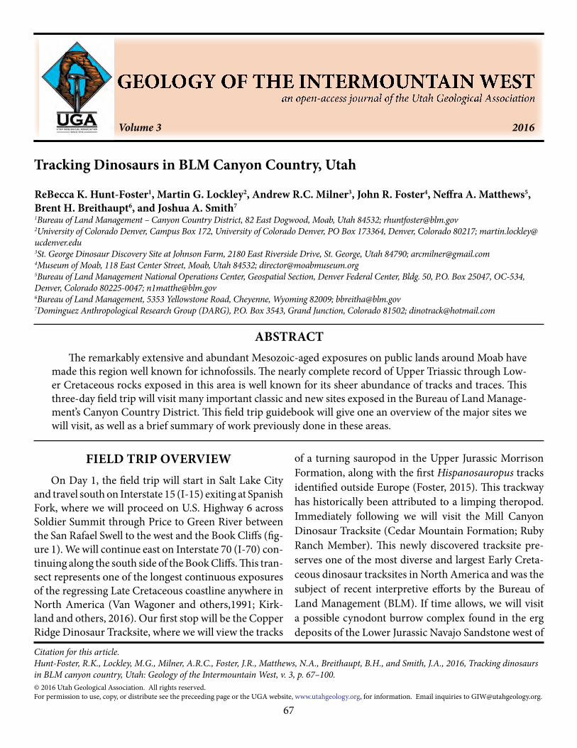
tion. In fact, in addition to the main tracksite area (fig-ure 3), which reveals at least 175 well-defined tracks and undertracks comprising more than 20 trackways, there are two nearby areas, one to the north, with ~35 tracks in at least eight trackways (Lockley and others, 2014c), and one to the east with ~30 tracks. Both these areas are within ~100 m of the main site and represent the same surface, which is intermittently exposed over a large area between and around these sites.
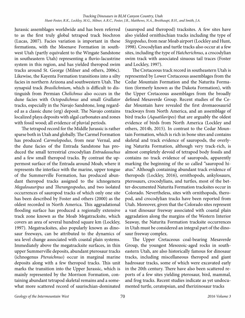
The MCDT was developed for public visitation and interpretation in 2014, opening to the public fully in April of 2016. Partly with such developments in mind the MCDT site has been subject to special study using innovative strategies. First the site was considerably en-larged, from the size of the original natural exposure, using mechanical excavation techniques, which are not often used at tetrapod tracksites. This phase of work was funded through Univerity of Colorado by the Korean National Research Institute of Cultural Heritage. Sec-ond, the site was subject to a thorough photogrammet-ric survey, which provided images for publications (e.g., Lockley and others, 2014b, figure 4) and interpretative signs. Third, a boardwalk up to 80 m long and 2 m wide was installed over the site so that visitors can “walk with the dinosaurs” without stepping on or damaging the tracks (figure 3). A shade structure was also installed. Utah Friends of Paleontology (UFOP), Moab Giants, Canyonlands Natural History Association (CNHA), and Grand County Trail Mix were community partners in these efforts during most phases of the project.
The MCDT has revealed a number of enigmatic traces that can broadly be described as slip and scratch marks. Some resemble swim tracks but cannot defini-tively be placed in this category. Likewise the largest of these traces, a pair of elongate grooves, are tentatively inferred to be of possible crocodylian origin (Lockley and others, 2014b). An herbivore coprolite was also found in the middle of the main site (Lockley and oth-
Figure 2 (figure on previous page). (A) Location of Copper Ridge Dinosaur Tracksite (after Foster, 2015). (B) Brontopodus tracks. (C) Map of tracksite by Lockley and Hunt (1995). (D) Example of photogrammetric model of the Copper Ridge Hispanosauropus trackway (Matthews, unpublished data). (E) Hispanosauropus (track 1, after Foster, 2015). (F) Participants of the Mid-Mesozoic field conference learning photogrammetry techniques on the Hispanosauropus trackway at Copper Ridge Dinosaur Tracksite from Neffra Matthews and Brent Breithaupt in 2014. (G) New interpretive signage installed at the Copper Ridge Dinosaur Tracksite by the BLM in 2016. Art by Brian Engh (dontmesswithdinosaurs.com).

74
Tracking Dinosaurs in BLM Canyon Country, UtahHunt-Foster, R.K., Lockley, M.G., Milner, A.R.C., Foster, J.R., Matthews, N.A., Breithaupt, B.H., and Smith, J.A.
Geology of the Intermountain West 2016 Volume 3
Figure 3. Caption on following page.
75
Tracking Dinosaurs in BLM Canyon Country, UtahHunt-Foster, R.K., Lockley, M.G., Milner, A.R.C., Foster, J.R., Matthews, N.A., Breithaupt, B.H., and Smith, J.A.
Geology of the Intermountain West 2016 Volume 3
ers, 2014c). The site has considerable potential for fur-ther excavation and future study.
Stop 3 – Synapsid Burrows
The Lower Jurassic (Pliensbachian-Toarcian) Na-vajo Sandstone of Utah, Colorado, New Mexico, and Arizona, along with the Nugget Sandstone to the north (Idaho, Wyoming) and the Aztec Sandstone to the south (Nevada, California), represents the largest erg to have
ever existed on Earth. Located on the western margin of Pangaea for almost 10 million years, this erg is esti-mated to have covered an area of approximately 644,000 km2 (400,000 mi2), now represented by over 322,000 km2 (200,000 mi2) of exposed eolian sandstone outcrop. Vertebrate and invertebrate trace fossils have long been known from the Navajo, and its equivalents, and are usually associated with relatively small carbonate lenses representing interdunal lakes.
At the Rocky Tops Burrow Site near Moab, Utah,
Figure 3 (figure on previous page). (A) Map of the Mill Canyon Dinosaur Tracksite (MCDT) modified after Lockley and others (2014c). (B) Carmelopodus-like track. (C) Irenesauripus. (D) Caririchnium-like track. (E) Hatcherichnus-like trace. The MCDT also contains sauropod tracks that include Brontopodus and manus-only sauropod undertracks. (F to H). Signage at the MCDT. (I) Completed trail, which opened on April 1, 2016. Scale = 10 cm (4 in). Photographs by BLM.
Figure 4. (A) Breithaupt and Matthews conducting systematic stereoscopic imagery acquisition of the main track-bearing surface at the Mill Canyon Dinosaur Tracksite (MCDT), Utah (Lower Cretaceous Cedar Mountain Formation) in summer 2014. (B) A single didactyl theropod track from MCDT (center image); color depth map with relative depths recorded in cm (left image); and Orthorectified image (right image), 1 mm (0.04 in) topographic contour map. (C) Orthorectified image mosaics composed of over 1000 images. Yellow inset box of area shown in 4D. (D) Inset showing detail of a small portion of the surface from 4C as a color depth map. (E) A single theropod track from MCDT (center image); color depth map with relative depths recorded in cm (left image); Orthorectified image (right image), 5 mm (0.2 in) topographic contour map. See Lockley and others (2014b) and Matthews and others (2016).

76
Tracking Dinosaurs in BLM Canyon Country, UtahHunt-Foster, R.K., Lockley, M.G., Milner, A.R.C., Foster, J.R., Matthews, N.A., Breithaupt, B.H., and Smith, J.A.
Geology of the Intermountain West 2016 Volume 3
“enigmatic” cylindrical and mounded sandstone struc-tures are present in eolian sandstone beds, at times below carbonate beds. Two main types of burrows are represented at this site: Type I and Type II (figure 5). Al-ternative interpretations proposed for these structures include rhizoliths, termite nests and other invertebrate traces, concretions, fluid escape features, and wind-ero-sion features (Lucas and others, 2006; Riese and oth-ers, 2011). Type I burrow structures have been defined as being comprised of high-density, complex networks of interconnected Y- and T-branching tunnels, with inclined ramps, horizontal to subhorizontal large-di-ameter structures preserved as differentially weath-ered low-relief mounds. The walls are predominantly smooth, with evidence of rhizoliths and small-diame-ter, passively filled burrows. These are most comparable with large complex burrow systems and mounds pro-duced by social and eusocial mammals that show in-terconnected, sinuous, and multiple branching tunnels and ramps. Whereas no body fossils of mammals have been found within the Navajo Sandstone (although the-rapsids have been found in this unit), modern animals
that dig similar structures include prairie dogs, voles, and naked mole rats. A few specimens observed by Riese and others (2011) exhibit scalloped walls, likely created by the organism’s hand during excavation mo-tions (figure 5).
Type II is represented by dorsoventrally flattened structures comprised of horizontal to subhorizontal, helical, curving, and simple branching tunnels that may lead to an enlarged chamber (figure 5, Smith, 1987; Groenewald and others, 2001; Miller and others, 2001; Hasiotis and others, 2004; Riese and others, 2011). These are thought to have been created by therapsids, based on their simple architecture, burrow diameter, and raised floors. They are typically less complex and less interconnected. Parallel longitudinal ridges on the surface of the burrows could possibly represent scratch-es produced by the organism’s claws, beaks, or incisors. These types of burrows likely represent a permanent dwelling and brooding structure. Similar modern tun-nels include those of alligators, crocodiles, some mon-itor lizards (Varanus mertensi), and skinks, along with modern mammals such as the platypus, armadillo, and
Figure 5. Type I and II burrows (from Riese and others, 2011). (A, C to E, and G) Y-branching structures—(C) with an out-ward branching structure and (D) with an outward branching element. (F) T- and Y-branching structures. (I to L) Sinuous architecture. (M and N) Surficial morphology of Type I structures with scallops marks by arrows. (N) Represents and extant mole burrow cast with scallops. (H and O) Type II structures and surficial morphology; (H) is the raised floor creating a bioturbated morphology and (O) shows three parallel ridges on the lobes, indicated by arrows. Scale bar = 1 cm.

77
Tracking Dinosaurs in BLM Canyon Country, UtahHunt-Foster, R.K., Lockley, M.G., Milner, A.R.C., Foster, J.R., Matthews, N.A., Breithaupt, B.H., and Smith, J.A.
Geology of the Intermountain West 2016 Volume 3
aardwolf. The Type II burrows were likely excavated by large tritylodontid therapsids, based on size and com-parisons to similar burrows from the Permian and Tri-assic of Antarctica and South Africa. A tritylodontid therapsid was recently found in the Navajo Sandstone in Sand Flats Recreation Area east of Moab. An additional Navajo Sandstone tritylodontid from Arizona was as-signed to Kayentatherium (Winkler and others, 1991) but was regarded as a mammalian cynodont of the Tri-tylodontidae by Sues and others (1994). This specimen was also found in interdunal deposits.
DAY 2: LATE TRIASSIC–EARLY JURASSIC OF SAN JUAN COUNTY
Lisbon Valley Stratigraphy and PaleontologyThe overall history and most recent lithostratigraph-
ic and vertebrate biostratigraphic assessment of Lisbon Valley were thoroughly covered by Martz and others (2014). The Upper Triassic Chinle Formation within Lisbon Valley is estimated to be late Norian-Rhaetian in age (~208-201 Ma) based on body fossils, especially aetosaurs and phytosaurs (Martz and others, 2014).
The Chinle Formation is unconformably underlain by the Lower Permian Cutler Group and overlain by the Upper Triassic-Lower Jurassic Wingate Sandstone (fig-ure 6). The Chinle in Lisbon Valley is divided into the Kane Springs beds capped by the Church Rock Member (also called the Dolores Formation in nearby Colorado and the Rock Point Formation in Arizona and New Mex-ico; Lucas (1993) refers to the Chinle as a group rather than formation). Salt tectonics in the region during the Triassic likely resulted in the complete erosion of the lower part of the Chinle Formation, the entire Moenko-pi Formation, and the upper part of the Cutler Group. Locally, the lower part of the Kane Springs beds incised paleovalleys into the Cutler Group (Martz and others, 2014). However, precise stratigraphic correlation of the Chinle Formation in the Lisbon Valley outlier is prob-lematic; especially the Kane Springs beds (Martz and others, 2014).
The uppermost Kane Springs beds contain a prom-inent conglomerate in the region called Black Ledge (Martz and others, 2014; figure 6). Another distinct unit
toward the top of the Church Rock Member is called Red Ledge (figure 6); again, mostly composed of con-glomerates deposited in a large braided river system. The Red Ledge beds are very fossiliferous. Finally, be-tween the contact of the Church Rock Member and the Lukachukai Member of the Wingate Sandstone is a mostly fluvial unit called the Big Indian Rock beds (Martz and others, 2014; figure 6). The Big Indian Rock beds contain the Last Phytosaur skull (see below) and important tracksites located on Eagle Nest Ridge (see discussion below) to the south.
Lisbon Valley ResearchCurrent investigation of Lisbon Valley began with
exhaustive and thorough fieldwork in 2004 through 2015 by Andrew R.C. Milner and the St. George Dino-saur Discovery Site at Johnson Farm (SGDS). In 2009, the Natural History Museum of Utah (UMNH) and other researchers from Colorado and Arizona joined the team resulting in spectacular findings of plants, in-vertebrates, vertebrates, and invertebrate and vertebrate trace fossils (figure 7). Extensive study of vertebrate body fossils from Lisbon Valley has been conducted on fishes (Schaeffer, 1967; Milner and others, 2006a, 2006b; Gibson, 2013a, 2013b, 2015), with some work on phyto-saurs, especially the Last Phytosaur (Morales and Ash, 1993; Lucas and others, 1997; Martz and others, 2014), and aetosaurs (Martz and others, 2014). Several publi-cations are presently being written to describe many of the new vertebrate specimens both from Lisbon Valley and Indian Creek (see discussion on Indian Creek), as well as the vertebrate trace fossils and localities summa-rized below (table 1).
Stop 4 – Lisbon ValleyCamp Hill Swimtracks (figure 8)
A set of large didactyl to tetradactyl swimtracks re-ferable to Characichnos isp. occur on a large fallen block of sandstone preserved in concave epirelief (Milner and Lockley, 2016; figure 8B). Swimtracks may represent punting marks left by a large phytosaur swimming or bottom-walking in a channel, although orientation of travel cannot be determined. The best preserved set of

78
Tracking Dinosaurs in BLM Canyon Country, UtahHunt-Foster, R.K., Lockley, M.G., Milner, A.R.C., Foster, J.R., Matthews, N.A., Breithaupt, B.H., and Smith, J.A.
Geology of the Intermountain West 2016 Volume 3
Figure 6. Stratigraphy of the Chinle Formation in the Lisbon Valley area. (A) Generalized stratigraphy of Skull Ridge showing the positions of Black Ledge and Red Ledge beds (modified from Ash and others, 2014). (B) Detailed stratigraphic section of Skull Ridge (modified from Martz and others, 2014). Unit/subunit numbers: 1 – Cutler Group, 2 – lower Kane Springs beds, 3 – middle Kane Springs beds, 4 – upper Kane Springs beds, 5a–Black Ledge, 5b to f – lower Church Rock Member, 6–Red Ledge, 7a to f – upper Church Rock Member, and 8–Wingate Sandstone. (C) Explanation for B (modified from Martz and others, 2014).

79
Tracking Dinosaurs in BLM Canyon Country, UtahHunt-Foster, R.K., Lockley, M.G., Milner, A.R.C., Foster, J.R., Matthews, N.A., Breithaupt, B.H., and Smith, J.A.
Geology of the Intermountain West 2016 Volume 3
swimtracks was replicated (SGDS 1196) and measures 30 cm long by 17 cm wide (12 in long by 7 in wide), and the deepest point being 1.7 cm (0.67 in) in the middle of the center digit. Sets of circular depressions arranged in arches may represent a trace called “Pentasauropus” (figure 8C; Lockley and Hunt, 1995), although identi-fication as actual trace fossils cannot be determined at this site.
The fallen block containing these tracks match-es well with the Red Ledge beds of the Church Rock Member above (Martz and others, 2014; figure 8A). The thicker sandstone layer is cross-bedded representing a broad, braided river system (Martz and others, 2014).
Additional in situ examples of smaller Characichnos traces occur to the southwest on Camp Hill with a swim direction toward the northwest. Other isolated swim tracks occur on Eagle Nest Ridge to the north and Three Step Hills to the south.
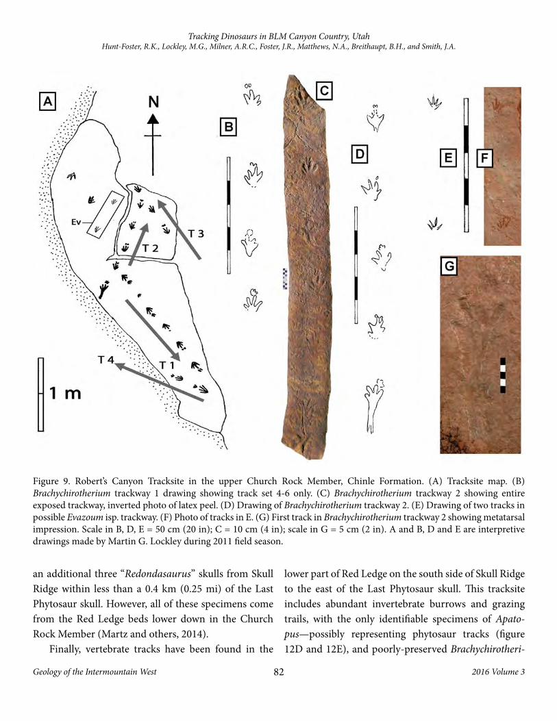
Robert’s Canyon Tracksite (figure 9)
This is a very informative tracksite set in a sequence of fluvial channel beds containing abundant invertebrate trace fossils throughout. This site is immediately below the Wingate Sandstone in the uppermost Church Rock Member of the Chinle Formation situated just above
Figure 7. Examples of vertebrate body fossils from the Chinle Formation of Lisbon Valley. (A) Hemicalypterus weiri Schaeffer, 1967 (USNM V 23425), composite part and counterpart image courtesy Sarah Z. Gibson (modified from Gibson, 2015). (B) Synorichthys stewarti Schaeffer, 1967 (UMNH VP 22906). (C) Lophionotus sanjuanenesis Gibson, 2013a (UMNH VP 19420A). (D) Tanaocrossus kalliokoskii Schaeffer, 1967 (UMNH VP 22905). (E) Lophionotus chinleana Gibson, 2013b (UMNH VP 19417 = holotype). (F) Partial articulated phytosaur skeleton with osteoderms, dorsal vertebrae, ribs, and pelvis (UMNH VP 24650). (G) Crocodylomorpha new genus and species partial skull (UMNH VP 21212). (H) “Redondasaurus” (Machaeroprosopus) sp. skull (UMNH VP 24304). (I) Typothorax coccinarum incomplete lateral osteoderm (UMNH VP 24232). Scales A-E and I = 1 cm (0.4 in); G = 2 cm (0.8 in); and F, H = 10 cm (4 in).

80
Tracking Dinosaurs in BLM Canyon Country, UtahHunt-Foster, R.K., Lockley, M.G., Milner, A.R.C., Foster, J.R., Matthews, N.A., Breithaupt, B.H., and Smith, J.A.
Geology of the Intermountain West 2016 Volume 3
the Red Ledge beds (Martz and others, 2014). Tracks occur on a high northern ridge in the step-walled “Rob-ert’s Canyon” named after its co-discoverers, Robert Baldazzi and Robert Gay. David Slauf, however, found this tracksite along with several other small tracksites located farther to the south and southeast of the Rob-ert’s Canyon locality. Most of these nearby tracksites only have Brachychirotherium preserved along with
deep mud cracks, and they resemble sites preserved to the north on the northeastern slope of Redd Ridge. Only one of these additional localities preserves a single Evazoum gatewayensis track.
The Robert’s Canyon Tracksite preserves abundant Brachychirotherium (figure 9A to 9D and 9G), although possible Evazoum (figure 9E and 9F) and Rhynchosau-roides tracks are also present. All tracks at this site are preserved in concave epirelief. Latex peels were created under permit for the longest Brachychirotherium track-way and for two small possible Evazoum tracks in a sin-gle trackway. Abundant smaller tracks were recognized over the entire surface after the latex peels were later examined at the SGDS. Because of the steep-walled can-yon, low-angle light on the tracksite surface makes these smaller tracks invisible. All of the tracks on this surface are small, compared to other sites in Lisbon Valley.
Eagle Nest Tracksites (figure 10)
The Big Indian Rock beds (Martz and others, 2014) at the contact between the Church Rock Member of the Chinle Formation and the Lukachukai Member of the Wingate Sandstone contain abundant tracks locally with most preserved as natural casts (figures 10A and 10B). Brachychirotherium (figure 10C) and small Grallator (figure 10D and 10E) are locally abundant, preserved in medium- to coarse-grained sandstone. Tracks occur on at least four stratigraphic levels and most surfaces have not been mapped because the ledges are long and nar-row with in-situ tracks on the undersides. One surface has poorly preserved Grallator in concave epirelief and can be oriented into its in-situ position (figure 10B and 10F). Grallator tracks range in size from 15.5 cm (6.1 in) long and 9 cm (4 in) wide to 6 cm (2 in) long and 4.5 cm (1.8 in) wide with several tracks displaying phalangeal pads. These Grallator tracks are small in comparison to older and larger Grallator found at a site near the base of the Red Ledge beds on Schaeffer Ridge to the south (figure 10G). Brachychirotherium cf. parvum are mostly incomplete and have an average length/width of 12 cm (5 in) by 14 cm (6 in), respectively.
Several small, in situ tracksites have also been re-corded within the lower part of the Lukachukai Mem-ber of the Wingate Sandstone on the southeastern side
Vertebrate Species Actinopterygii indet. Hemicalypterus weiri Schaeffer, 1967 (Fig. 7A) Lophionotus sanjuanenesis Gibson, 2013a (Fig. 7C) Lophonotus chinleana Gibson, 2013b (Fig. 7E) Synorichthys stewarti Schaeffer, 1967 (Fig. 7B) Cionichthys dunklei Schaeffer, 1967 Lasalichthys hillsi Schaeffer, 1967 Tanaocrossus kalliokoskii Schaeffer, 1967 (Fig. 7D) Tanaocrossus sp. Arganodus dorotheae (Case, 1921) Chinlea sorenseni Schaeffer, 1967
Phytosauria indet. (Fig. 7F) Pseudopalatine indet. “Redondasaurus” (Machaeroprosopus) sp. (Fig. 7H) Machaeroprosopus sp.
Aetosauria indet. Typothorax sp. Typothorax coccinarum Cope, 1875 (Fig. 7I)
Paracrocodylomorpha indet. Crocodylomorpha indet. Crocodylomorpha n. gen. et sp. (Fig. 7G) Vertebrate Ichnofossils Undichna isp. Rhynchosauroides isp. Gwyneddichnium isp. Brachychirotherium parvum (Hitchcock, 1889) Brachychirotherium sp. Evazoum gatewayensis Lockley and Lucas, 2013 Evazoum isp. “Pseudotetrasauropus” isp. “Pentasauropus”? Apatopus isp. Grallator isp. Grallator? Characichnos isp.
Table 1. Species and ichnospecies lists for the Chinle Forma-tion in the Lisbon Valley area.

81
Tracking Dinosaurs in BLM Canyon Country, UtahHunt-Foster, R.K., Lockley, M.G., Milner, A.R.C., Foster, J.R., Matthews, N.A., Breithaupt, B.H., and Smith, J.A.
Geology of the Intermountain West 2016 Volume 3
of Eagle Nest Ridge. All of the tracks on these surfaces are natural cast of theropod footprints, many attributed to Grallator (figure 10H and 10I).
Redd Ridge North and South (figure 11)
At least two stratigraphic levels of tracks on the north side of Redd Ridge in the upper Church Rock Member preserve footprints in concave epirelief and convex hy-porelief respectively. Small and large mudcracks are present on both surfaces. Unfortunately, dense foliage on very steep, covered slopes, makes their exact strati-graphic position uncertain. The natural cast surface re-sembles desiccated horizons to the south near Robert’s Canyon, north of Steen Canyon, and farther to the west in the Indian Creek area. Only Brachychirotherium are preserved at all of these localities (figure 11A to 11C).
On the southeast side of Redd Ridge, two large fall-en blocks covered in current ripple marks have two long and parallel Evazoum gatewayensis trackways (figure 11D and 11E) and a shorter Brachychirotherium track-way. By looking at the block shapes, both can then be ori-
ented into their correct positions so that trackway direc-tions in relationship to current flow can be determined. These tracks along with a nearby block containing swim tracks (figure 11F) come from the uppermost portion of the Red Ledge beds of the Church Rock Member.
Stop 5 – Last Phytosaur (figure 12)The Last Phytosaur represents the dorsal impression
of a pseudopalatine phytosaur skull probably referable to “Redondasaurus” (figure 12A and 12B). The name Last Phytosaur was coined by Morales and Ash (1993) because of the skulls stratigraphic position, either in the basal Wingate Sandstone, or within the uppermost Church Rock Member of the Chinle Formation (see also Lucas and others, 1997). Martz and others (2014) named the unit (8a in figure 12C) the Big Indian Rock beds, placing it within the lowermost Wingate.
Morales and Ash (1993) mention a second skull found nearby and this may be represented by MNA V10650 which was recently prepared at the SGDS. In recent years the SGDS and UMNH crews have collected
Figure 8. Camp Hill outcrop and tracks. (A) Locality of fallen phytosaur swim track block (red arrow) showing where it originated from in the Red Ledge beds (yellow arrow), Church Rock Member, Chinle Formation. Photo courtesy of Jeff Martz (University of Houston). (B) Best set of large phytosaur swim tracks (i.e., Characichnos isp. = SGDS 1196 replica). Scale = 10 cm. (C) cf. “Pentasauropus” on same surface with swim tracks.
82
Tracking Dinosaurs in BLM Canyon Country, UtahHunt-Foster, R.K., Lockley, M.G., Milner, A.R.C., Foster, J.R., Matthews, N.A., Breithaupt, B.H., and Smith, J.A.
Geology of the Intermountain West 2016 Volume 3
an additional three “Redondasaurus” skulls from Skull Ridge within less than a 0.4 km (0.25 mi) of the Last Phytosaur skull. However, all of these specimens come from the Red Ledge beds lower down in the Church Rock Member (Martz and others, 2014).
Finally, vertebrate tracks have been found in the
lower part of Red Ledge on the south side of Skull Ridge to the east of the Last Phytosaur skull. This tracksite includes abundant invertebrate burrows and grazing trails, with the only identifiable specimens of Apato-pus—possibly representing phytosaur tracks (figure 12D and 12E), and poorly-preserved Brachychirotheri-
Figure 9. Robert’s Canyon Tracksite in the upper Church Rock Member, Chinle Formation. (A) Tracksite map. (B) Brachychirotherium trackway 1 drawing showing track set 4-6 only. (C) Brachychirotherium trackway 2 showing entire exposed trackway, inverted photo of latex peel. (D) Drawing of Brachychirotherium trackway 2. (E) Drawing of two tracks in possible Evazoum isp. trackway. (F) Photo of tracks in E. (G) First track in Brachychirotherium trackway 2 showing metatarsal impression. Scale in B, D, E = 50 cm (20 in); C = 10 cm (4 in); scale in G = 5 cm (2 in). A and B, D and E are interpretive drawings made by Martin G. Lockley during 2011 field season.

83
Tracking Dinosaurs in BLM Canyon Country, UtahHunt-Foster, R.K., Lockley, M.G., Milner, A.R.C., Foster, J.R., Matthews, N.A., Breithaupt, B.H., and Smith, J.A.
Geology of the Intermountain West 2016 Volume 3
um (figure 12F). The Red Ledge beds represent a thick braided river sequence (Martz and others, 2014).
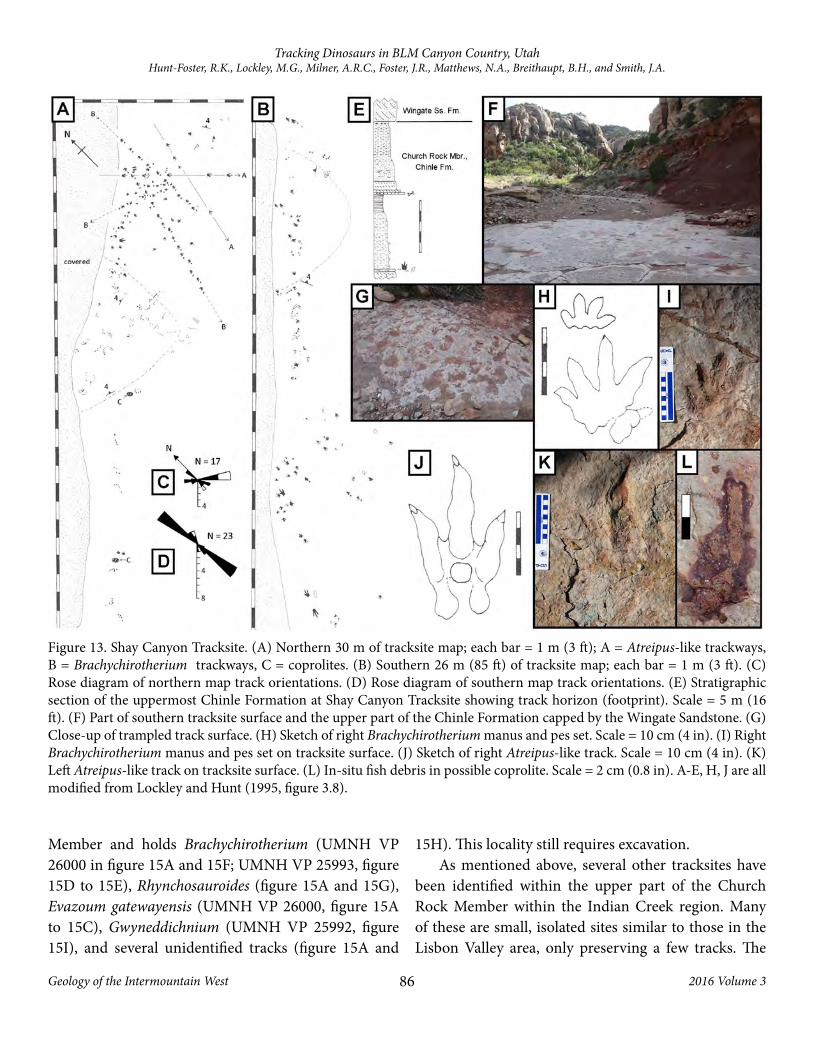
Stop 6 – Shay Canyon Tracksite (figure 13)Upon entering the Indian Creek Valley from the
south, we drive down through the Kayenta Formation,
underlain by the Wingate Sandstone, and the Chinle Formation. In the uppermost part of the Church Rock Member of the Chinle, approximately 15 m below the Chinle-Wingate contact lies the Shay Canyon Tracksite (Lockley and Hunt, 1995, p. 77–78, figure 3.8; called Rock Point Formation by Hunt and Lucas, 2007, p. 223).
Figure 10. Eagle Nest Ridge Tracksites. (A) Southeast side of Eagle Nest Ridge showing the position of the track-bearing Big Indian Rock beds and Lukachukai Member of the Wingate Sandstone. (B) Track-bearing Big Indian Rock beds on Eagle Nest Ridge. The two upper fallen slabs are those mapped in F. (C) In situ natural cast tracks on underside of ledge in Big Indian Rock beds. Brachychirotherium (white arrow left center) and Grallator (yellow arrow top right). (D) Isolated Grallator natural cast from Big Indian Rock beds (UMNH VP 24637). Scale = 2 cm (0.8 in). (E) Grallator natural cast (UMNH VP 21876). Scale = 2 cm (0.8 in). (F) Two mapped Grallator-dominated slabs in B. Scale = 10 cm (4 in). (G) Two natural cast Grallator tracks from the base of Red Ledge beds of Church Rock Member from Schaeffer Ridge. These are the largest Grallator from the Chinle Formation of the region (UMNH VP 22885). Scale = 5 cm. (H) Natural cast tracks preserved in Lukachukai Member on Eagle Nest Ridge (photo courtesy David Slauf, volunteer at SGDS). (I) Same track surface as in H showing at least 20 theropod tracks on two stratigraphic levels (photo courtesy David Slauf).

84
Tracking Dinosaurs in BLM Canyon Country, UtahHunt-Foster, R.K., Lockley, M.G., Milner, A.R.C., Foster, J.R., Matthews, N.A., Breithaupt, B.H., and Smith, J.A.
Geology of the Intermountain West 2016 Volume 3
Although only briefly described by Lockley and Hunt (1995), very little has been published on this very large tracksite, which is by far the largest Chinle track-site exposed in the region. The site preserves over 250 tracks on a single bedding surface (figure 13A), dom-inated by Brachychirotherium tracks and trackways (figure 13B). Less common Atreipus-like tracks are also reported, along with possible Pentasauropus tracks (Lockley and Hunt, 1995; figure 3.10). Other problem-
atic tracks include several enigmatic scratch and scrape marks, which were first interpreted as phytosaur swim tracks, although this is highly speculative (Lockley and Hunt, 1995). Hunt and Lucas (2007) identify tracks at the Shay Canyon site as Brachychirotherium thuringi-acum, Anchisauripus sillimani, and Pentasauropus sp. Several patches of fish debris (figure 13C) have been interpreted as coprolites by Lockley and Hunt (1995). It is possible that these are simply disarticulated and/or
Figure 11. Tracks from Redd Ridge. (A) Brachychirotherium parvum trackway with mudcracks preserved as actual tracks (UMNH VP 22334). Scale = 10 cm (4 in). (B) Close-up of second set manus and pes tracks in A. Scale = 5 cm (2 in). (C) Partial Brachychirotherium trackway with unusual gate. First pes tracks has elongate metatarsal impression (UMNH VP 21875). Scale = 10 cm (4 in). (D) Two large current ripple-covered Evazoum track blocks fallen from Red Ledge beds in background with Wingate Sandstone behind that. (E) Latex peel showing examples of two Evazoum gatwayensis tracks in trackway from lower block shown in D. (F) Possible swim track set from Red Ledge beds. Scale = 5 cm (2 in).

85
Tracking Dinosaurs in BLM Canyon Country, UtahHunt-Foster, R.K., Lockley, M.G., Milner, A.R.C., Foster, J.R., Matthews, N.A., Breithaupt, B.H., and Smith, J.A.
Geology of the Intermountain West 2016 Volume 3
associated fish remains since fossil fishes are very abun-dant locally within the Church Rock Member in both the Indian Creek and Lisbon Valley areas.
At Indian Creek, the Chinle Formation unconform-ably overlies the Lower Triassic Moenkopi Formation which is very thin here compared to other areas. The lower member of the Chinle superficially resembles the Kane Springs beds as seen in Lisbon Valley, but is identified as the Owl Rock Member (Martz and others, 2014). The upper member is the Church Rock Member capped by the Wingate Sandstone (figure 14).
Fossils are locally abundant within the Chinle For-mation and Wingate Sandstone in Indian Creek. Phy-
tosaurs, aetosaurs, crocodylomorphs, theropods, me-toposaurs, and a variety of fishes have been collected in the Indian Creek valley from 2013-2016 by UMNH and SGDS field crews. Several small tracksites have also been recognized in the upper part of the Owl Rock (see Track City below) and Church Rock Members of the Chinle, and the Lukachukai Member of the Wingate.
Stop 7 – Track City (figure 15)The “Track City” Tracksite is the oldest tracksite in
the Chinle Formation known from the Indian Creek area. It is located in the upper part of the Owl Rock
Figure 12. “Last Phytosaur” and tracks found nearby on Skull Ridge. (A) In situ pseudopalatine phytosaur skull impression at Last Phytosaur locality. Note white bone to the right in photos and abundance of large associated mudstone clasts. Jeff Martz pictured for scale. (B) Close-up of Last Phytosaur skull. Green clay still remains in replica from first replication of specimen housed at Museum of Northern Arizona (MNA). Yellowish material is old latex left behind from a failed replica attempt. This has since been removed for UMNH and SGDS latex peel. Finger on right is pointing to end of snout. Scale = 10 cm (4 in). (C) Stratigraphic section through Last Phytosaur site (black arrow) situated in Big Indian Rock beds (unit 8a) in basal Wingate Sandstone (modified from Martz and others, 2014). (D) Apatopus natural cast tracks (UMNH VP 24921). Scale = 2 cm (0.8 in). (E) Apatopus natural cast tracks (UMNH VP 24919). Scale = 2 cm (0.8 in). (F) Pair of Brachychirotherium natural cast tracks with abundant invertebrate burrows (UMNH VP 24920). Scale = 5 cm (2 in).
86
Tracking Dinosaurs in BLM Canyon Country, UtahHunt-Foster, R.K., Lockley, M.G., Milner, A.R.C., Foster, J.R., Matthews, N.A., Breithaupt, B.H., and Smith, J.A.
Geology of the Intermountain West 2016 Volume 3
Member and holds Brachychirotherium (UMNH VP 26000 in figure 15A and 15F; UMNH VP 25993, figure 15D to 15E), Rhynchosauroides (figure 15A and 15G), Evazoum gatewayensis (UMNH VP 26000, figure 15A to 15C), Gwyneddichnium (UMNH VP 25992, figure 15I), and several unidentified tracks (figure 15A and
15H). This locality still requires excavation.As mentioned above, several other tracksites have
been identified within the upper part of the Church Rock Member within the Indian Creek region. Many of these are small, isolated sites similar to those in the Lisbon Valley area, only preserving a few tracks. The
Figure 13. Shay Canyon Tracksite. (A) Northern 30 m of tracksite map; each bar = 1 m (3 ft); A = Atreipus-like trackways, B = Brachychirotherium trackways, C = coprolites. (B) Southern 26 m (85 ft) of tracksite map; each bar = 1 m (3 ft). (C) Rose diagram of northern map track orientations. (D) Rose diagram of southern map track orientations. (E) Stratigraphic section of the uppermost Chinle Formation at Shay Canyon Tracksite showing track horizon (footprint). Scale = 5 m (16 ft). (F) Part of southern tracksite surface and the upper part of the Chinle Formation capped by the Wingate Sandstone. (G) Close-up of trampled track surface. (H) Sketch of right Brachychirotherium manus and pes set. Scale = 10 cm (4 in). (I) Right Brachychirotherium manus and pes set on tracksite surface. (J) Sketch of right Atreipus-like track. Scale = 10 cm (4 in). (K) Left Atreipus-like track on tracksite surface. (L) In-situ fish debris in possible coprolite. Scale = 2 cm (0.8 in). A-E, H, J are all modified from Lockley and Hunt (1995, figure 3.8).

87
Tracking Dinosaurs in BLM Canyon Country, UtahHunt-Foster, R.K., Lockley, M.G., Milner, A.R.C., Foster, J.R., Matthews, N.A., Breithaupt, B.H., and Smith, J.A.
Geology of the Intermountain West 2016 Volume 3
Figure 14. Generalized stratigraphy of the Indian Creek valley and view of Bridger Jack Mesa showing the Owl Rock and Church Rock Members making up the Chinle Formation, capped by the Wingate Sandstone.
Figure 15. Examples of vertebrate tracks from the “Track City” locality situated in the upper part of the Owl Rock Member, Chinle Formation. (A) Discovery block containing actual tracks in fine-grained sandstone (UMNH VP 26000). Scale = 10 cm (4 in). (B) large, well-preserved Evazoum gatewayensis track (UMNH VP 26000). Scale = 5 cm (2 in). (C) Two partial Evazoum tracks only displaying digits III and IV (UMNH VP 26000). Scale = 2 cm (0.8 in). (D to E) Brachychirotherium track through thick sediment, showing the track outline and infill, and the undertrack on opposite side (UMNH VP 25993). Scale = 5 cm (2 in). (F) Brachychirotherium manus and pes set (UMNH VP 26000). Scale = 5 cm (2 in). (G) Rhynchosauroides isp. (UMNH VP 26000). Scale = 1 cm (0.4 in). (H) unidentified small tracks (UMNH VP 26000). Scale = 1 cm (0.4 in). (I) Actual track that likely represents Gwyneddichnium pes with possible metatarsal impression (UMNH VP 25992). Scale = 2 cm (0.8 in).
88
Tracking Dinosaurs in BLM Canyon Country, UtahHunt-Foster, R.K., Lockley, M.G., Milner, A.R.C., Foster, J.R., Matthews, N.A., Breithaupt, B.H., and Smith, J.A.
Geology of the Intermountain West 2016 Volume 3
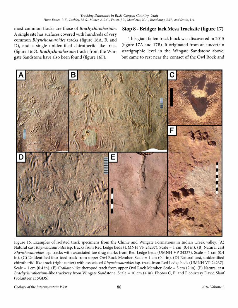
most common tracks are those of Brachychirotherium. A single site has surfaces covered with hundreds of very common Rhynchosauroides tracks (figure 16A, B, and D), and a single unidentified chirotheriid-like track (figure 16D). Brachychirotherium tracks from the Win-gate Sandstone have also been found (figure 16F).
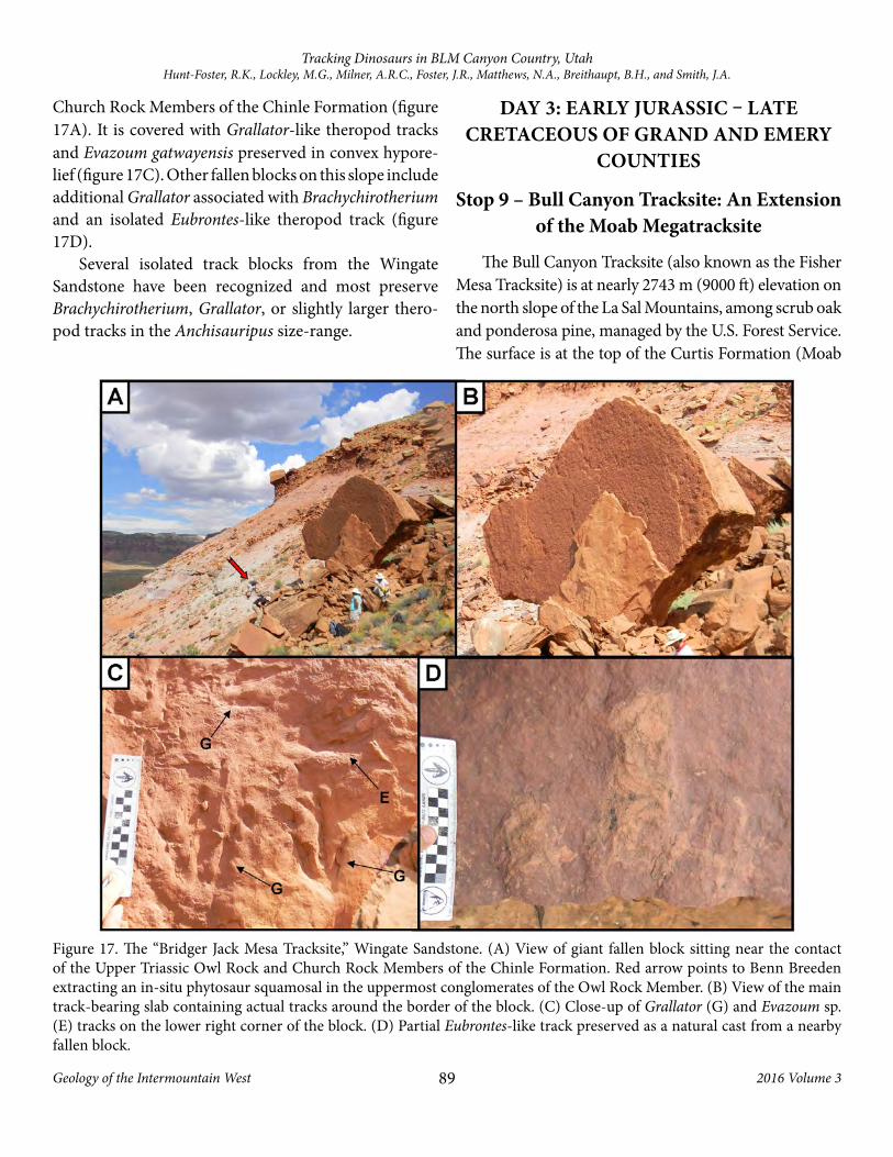
Stop 8 - Bridger Jack Mesa Tracksite (figure 17)
This giant fallen track block was discovered in 2015 (figure 17A and 17B). It originated from an uncertain stratigraphic level in the Wingate Sandstone above, but came to rest near the contact of the Owl Rock and
Figure 16. Examples of isolated track specimens from the Chinle and Wingate Formations in Indian Creek valley. (A) Natural cast Rhynchosauroides isp. tracks from Red Ledge beds (UMNH VP 24237). Scale = 1 cm (0.4 in). (B) Natural cast Rhynchosauroides isp. tracks with associated toe drag marks from Red Ledge beds (UMNH VP 24237). Scale = 1 cm (0.4 in). (C) Unidentified four-toed track from upper Owl Rock Member. Scale = 1 cm (0.4 in). (D) Natural cast, unidentified chirotheriid-like track (right center) with associated Rhynchosauroides isp. track from Red Ledge beds (UMNH VP 24237). Scale = 1 cm (0.4 in). (E) Grallator-like theropod track from upper Owl Rock Member. Scale = 5 cm (2 in). (F) Natural cast Brachychirotherium-like trackway from Wingate Sandstone. Scale = 10 cm (4 in). Photos C, E, and F courtesy David Slauf (volunteer at SGDS).
89
Tracking Dinosaurs in BLM Canyon Country, UtahHunt-Foster, R.K., Lockley, M.G., Milner, A.R.C., Foster, J.R., Matthews, N.A., Breithaupt, B.H., and Smith, J.A.
Geology of the Intermountain West 2016 Volume 3
Church Rock Members of the Chinle Formation (figure 17A). It is covered with Grallator-like theropod tracks and Evazoum gatwayensis preserved in convex hypore-lief (figure 17C). Other fallen blocks on this slope include additional Grallator associated with Brachychirotherium and an isolated Eubrontes-like theropod track (figure 17D).
Several isolated track blocks from the Wingate Sandstone have been recognized and most preserve Brachychirotherium, Grallator, or slightly larger thero-pod tracks in the Anchisauripus size-range.
DAY 3: EARLY JURASSIC – LATE CRETACEOUS OF GRAND AND EMERY
COUNTIES
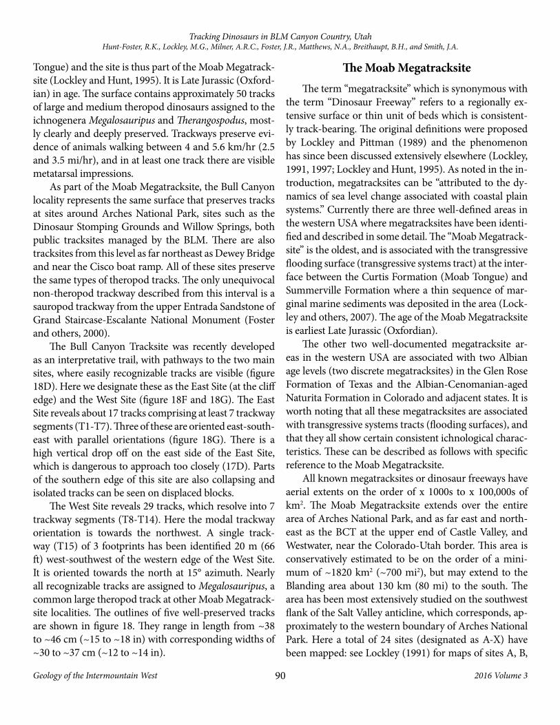
Stop 9 – Bull Canyon Tracksite: An Extension of the Moab Megatracksite
The Bull Canyon Tracksite (also known as the Fisher Mesa Tracksite) is at nearly 2743 m (9000 ft) elevation on the north slope of the La Sal Mountains, among scrub oak and ponderosa pine, managed by the U.S. Forest Service. The surface is at the top of the Curtis Formation (Moab
Figure 17. The “Bridger Jack Mesa Tracksite,” Wingate Sandstone. (A) View of giant fallen block sitting near the contact of the Upper Triassic Owl Rock and Church Rock Members of the Chinle Formation. Red arrow points to Benn Breeden extracting an in-situ phytosaur squamosal in the uppermost conglomerates of the Owl Rock Member. (B) View of the main track-bearing slab containing actual tracks around the border of the block. (C) Close-up of Grallator (G) and Evazoum sp. (E) tracks on the lower right corner of the block. (D) Partial Eubrontes-like track preserved as a natural cast from a nearby fallen block.
90
Tracking Dinosaurs in BLM Canyon Country, UtahHunt-Foster, R.K., Lockley, M.G., Milner, A.R.C., Foster, J.R., Matthews, N.A., Breithaupt, B.H., and Smith, J.A.
Geology of the Intermountain West 2016 Volume 3
Tongue) and the site is thus part of the Moab Megatrack-site (Lockley and Hunt, 1995). It is Late Jurassic (Oxford-ian) in age. The surface contains approximately 50 tracks of large and medium theropod dinosaurs assigned to the ichnogenera Megalosauripus and Therangospodus, most-ly clearly and deeply preserved. Trackways preserve evi-dence of animals walking between 4 and 5.6 km/hr (2.5 and 3.5 mi/hr), and in at least one track there are visible metatarsal impressions.
As part of the Moab Megatracksite, the Bull Canyon locality represents the same surface that preserves tracks at sites around Arches National Park, sites such as the Dinosaur Stomping Grounds and Willow Springs, both public tracksites managed by the BLM. There are also tracksites from this level as far northeast as Dewey Bridge and near the Cisco boat ramp. All of these sites preserve the same types of theropod tracks. The only unequivocal non-theropod trackway described from this interval is a sauropod trackway from the upper Entrada Sandstone of Grand Staircase-Escalante National Monument (Foster and others, 2000).
The Bull Canyon Tracksite was recently developed as an interpretative trail, with pathways to the two main sites, where easily recognizable tracks are visible (figure 18D). Here we designate these as the East Site (at the cliff edge) and the West Site (figure 18F and 18G). The East Site reveals about 17 tracks comprising at least 7 trackway segments (T1-T7). Three of these are oriented east-south-east with parallel orientations (figure 18G). There is a high vertical drop off on the east side of the East Site, which is dangerous to approach too closely (17D). Parts of the southern edge of this site are also collapsing and isolated tracks can be seen on displaced blocks.
The West Site reveals 29 tracks, which resolve into 7 trackway segments (T8-T14). Here the modal trackway orientation is towards the northwest. A single track-way (T15) of 3 footprints has been identified 20 m (66 ft) west-southwest of the western edge of the West Site. It is oriented towards the north at 15° azimuth. Nearly all recognizable tracks are assigned to Megalosauripus, a common large theropod track at other Moab Megatrack-site localities. The outlines of five well-preserved tracks are shown in figure 18. They range in length from ~38 to ~46 cm (~15 to ~18 in) with corresponding widths of ~30 to ~37 cm (~12 to ~14 in).
The Moab MegatracksiteThe term “megatracksite” which is synonymous with
the term “Dinosaur Freeway” refers to a regionally ex-tensive surface or thin unit of beds which is consistent-ly track-bearing. The original definitions were proposed by Lockley and Pittman (1989) and the phenomenon has since been discussed extensively elsewhere (Lockley, 1991, 1997; Lockley and Hunt, 1995). As noted in the in-troduction, megatracksites can be “attributed to the dy-namics of sea level change associated with coastal plain systems.” Currently there are three well-defined areas in the western USA where megatracksites have been identi-fied and described in some detail. The “Moab Megatrack-site” is the oldest, and is associated with the transgressive flooding surface (transgressive systems tract) at the inter-face between the Curtis Formation (Moab Tongue) and Summerville Formation where a thin sequence of mar-ginal marine sediments was deposited in the area (Lock-ley and others, 2007). The age of the Moab Megatracksite is earliest Late Jurassic (Oxfordian).
The other two well-documented megatracksite ar-eas in the western USA are associated with two Albian age levels (two discrete megatracksites) in the Glen Rose Formation of Texas and the Albian-Cenomanian-aged Naturita Formation in Colorado and adjacent states. It is worth noting that all these megatracksites are associated with transgressive systems tracts (flooding surfaces), and that they all show certain consistent ichnological charac-teristics. These can be described as follows with specific reference to the Moab Megatracksite.
All known megatracksites or dinosaur freeways have aerial extents on the order of x 1000s to x 100,000s of km2. The Moab Megatracksite extends over the entire area of Arches National Park, and as far east and north-east as the BCT at the upper end of Castle Valley, and Westwater, near the Colorado-Utah border. This area is conservatively estimated to be on the order of a mini-mum of ~1820 km2 (~700 mi2), but may extend to the Blanding area about 130 km (80 mi) to the south. The area has been most extensively studied on the southwest flank of the Salt Valley anticline, which corresponds, ap-proximately to the western boundary of Arches National Park. Here a total of 24 sites (designated as A-X) have been mapped: see Lockley (1991) for maps of sites A, B,
91
Tracking Dinosaurs in BLM Canyon Country, UtahHunt-Foster, R.K., Lockley, M.G., Milner, A.R.C., Foster, J.R., Matthews, N.A., Breithaupt, B.H., and Smith, J.A.
Geology of the Intermountain West 2016 Volume 3
C, W, and X, and two additional sites on the northeast flank of the anticline, Lockley and others (2000a, 2000b) for photographs of site E, and tracks from other sites, Lockley and Hunt (1995) for a map of site Q, with more than 2000 footprints. The latter site has been designated as an interpretative site by the BLM and has been called the “Dinosaur Stomping Ground.”
With the addition of other known sites, the Moab Megatracksite is based on a total of at least 30 reported sites. The only tracks found at all these sites are large- and medium-sized theropod tracks named Megalosauripus and Therangospodus, respectively (figure 19B to 19E). Thus, the ~3000 tracks reported from ~30 sites represent only two morphotypes. Such site-to-site track-type con-sistency indicates a scientific repeatability of results that strongly suggests that tracksites are reliable indicators or censuses of the faunas that occupied this region at this time in the Middle to Late Jurassic transition. The oth-er aforementioned Cretaceous megatracksites also show site-to-site consistency in the track types, based on sam-ples of between ~42 sites in Texas and ~120 sites in the Colorado area.
Studies of tracks found just below and just above the Moab Megatracksite surfaces indicate quite different fau-nas inhabiting the region just before and after the mega-tracksite was registered. In the eolian dune deposits, just below, small crow-sized theropod tracks (Wildeichnus) occur, whereas just above, in the marginal marine depos-its of the upper tongue of the Summerville Formation, pterosaur tracks (Pteraichnus) are regionally distrib-uted. A fourth suite of theropod, sauropod, stegosaur, and crocodylian tracks occur in the overlying Salt Wash Member of the Morrison Formation (Lockley and others, 2007, figure 2 = figure 19 herein).
Stop 10 – Poison Spider Dinosaur Tracksite
As mentioned earlier, the Navajo Sandstone in south-eastern Utah represents possibly the largest erg ever to de-velop during the Phanerozoic (Parrish and Falcon-Lang, 2007). Multiple occurrences of carbonate beds, repre-senting spring-fed lakes that ponded between dunes, are present in the Navajo Sandstone in the Moab area. These carbonate beds, and other siliciclastic water-lain inter-dune deposits, frequently preserve a variety of dinosaur
tracks, most notably Eubrontes, Grallator, Otozoum, and Anomoepus. Elsewhere in the Moab area, large clusters of conifer tree remains occur in association with these interdunal deposits. The presence of these conifers has been inferred to represent long-lived pluvial episodes where the erg was stabilized. Alternatively they may re-flect erg-margin locations in this area of the Colorado Plateau (Parrish and Falcon-Lang, 2007).
The tracks known from the Poison Spider Dinosaur Tracksite represent a variety of theropod dinosaurs, rang-ing in size from very small to over 1.5 m at the hips. The tracks on the main blocks represent up to 10 different animals. The rocks containing the tracks fell from the Navajo Sandstone cliffs, split along the bedding planes and now rest on the Kayenta Formation, which makes up the slopes below the cliff (figure 20A). Both true tracks and the corresponding natural casts occur on the main slabs, and mostly represent Eubrontes and Grallator (fig-ure 20E).
The larger, upper track slab, first documented by the BLM in 1965, was later mapped by Lockley and Hunt (1995, figure 20B). The block had tilted outward from the cliff base, revealing Eubrontes and Grallator, but also the type specimen of Anomoepus moabensis, a small three-toed bird-like track produced by ornithischian dinosaurs (figure 20D and 20F). More than 24 theropod tracks of various sizes are preserved here (see figure 20C).
Whereas tracks are very common and well known from these interdune deposits, body fossils for dinosaurs of this age are very rare, with only one dinosaur, Seitaad, having been found in the Navajo Sandstone in Utah (Ser-tich and Loewen, 2010), and one small theropod, Segis-aurus, known from Arizona (Camp, 1936, figure 20G). Thus, most information on Early Jurassic life at this time is based on trackways, such as these, which are very com-mon in interdune units within the Navajo.
Stop 11– Moline Reef TracksiteThe Moilne Reef Tracksite represents an ornithopod
tracksite in the Upper Cretaceous (Turonian) Ferron Sandstone Member of the Mancos Shale (DeCourten, 1998; Jones, 2001; Kirkland and Madsen, 2007; figure 21). This deltaic/coastal environment represented by the Ferron Sandstone has only rarely produced tracks with-

92
Tracking Dinosaurs in BLM Canyon Country, UtahHunt-Foster, R.K., Lockley, M.G., Milner, A.R.C., Foster, J.R., Matthews, N.A., Breithaupt, B.H., and Smith, J.A.
Geology of the Intermountain West 2016 Volume 3
Figure 18. Caption on following page.

93
Tracking Dinosaurs in BLM Canyon Country, UtahHunt-Foster, R.K., Lockley, M.G., Milner, A.R.C., Foster, J.R., Matthews, N.A., Breithaupt, B.H., and Smith, J.A.
Geology of the Intermountain West 2016 Volume 3
in Utah. The Moilne Reef Tracksite is located on a fallen sandstone block, which fell out of the escarpment located directly north of the site. The tracks are preserved as nat-ural casts and true tracks. There are nine tridactyl tracks preserved, which are not well-defined, and manus tracks were noted by Gierlinski and Lockley (2013, figure 24.2A and B). The footfalls in the Moilne Reef Tracksite show a
consistent 97 cm (38 in) length in the left and right paces, and the animal is estimated to be roughly 72 cm (0.3 in) tall at the hips (Jones, 2001).
Stop 12 – Tracks from the Mesaverde GroupSince the 1920s Upper Cretaceous tetrapod tracks
have been reported from the coal-bearing strata of the broadly defined Mesaverde Group (Campanian and Maastrichtian) at various sites in Utah, Colorado, and Wyoming, especially around the Price coal mining dis-trict of Utah and Grand Mesa in western Colorado (Car-penter, 1992). During the deposition of this unit, swamps were developing in interdeltaic to coastal plain environ-ments (Parker and Balsley, 1989; Carpenter, 1992). Some tracks have been extracted as isolated casts from the roofs of coal mines (Peterson, 1924) whereas others have been described from surface exposures (Robison, 1991; Lockley and others, 2011). In the 1930s the tracks were often treated sensationally, as in the case of Peterson’s claim of a Tyrannosaurus track and Barnum Brown’s ex-cavation of a slab for the American Museum with tracks he attributed to a “mystery dinosaur” with a giant stride (Brown, 1938). These latter interpretations figured in 1970s debates about dinosaur speed, as well as by Car-penter (1992). Only in a few cases have large surfaces with trackway segments been mapped in detail (Lockley and others, 1983, 2011; Parker and Balsley, 1989).
Tracks occurring in the Campanian Blackhawk For-mation of Utah, near Price, Utah, have frequently been discovered in coal mines near the area, and are common-ly known to locals. A large collection of trackways from these coal mines can be found at the Utah State Univer-
Figure 19. Tracks from Dinosaur Stomping Grounds (DSG) in the Upper Jurassic Curtis Formation (Moab Tongue). (A and B) Megalosauripus tracks found at DSG. (C and D) Therangospodus tracks at other sites around the Moab Megatracksite area, west of Arches National Park, on BLM lands. Photographs by ReBecca Hunt-Foster.
Figure 18 (figure on previous page). Bull Canyon Dinosaur Tracksite (BCT) on National Forest Service Land, east of Moab, Utah. A selection of theropod tracks from the BCT (Fischer Mesa Tracksite) were photogrammetrically documented in 2004. Above (from left to right columns) are (A) Color depth maps, (B) Orthographic images, and (C) Topographic contour maps (5 mm [0.2 in] contours). All graphics are depicted at a uniform scale. Scale bar is 50 cm (20 in) in length. A camera cali-bration photo set (see Matthews and others, 2016) was taken for each track; however, multiview matching software was not yet available and calibrated objects of known length had not been developed. The coded targets, visible in the orthographic image map, were place around the subject to aid in manual image alignment necessary in the software of the day. (D) Andrew Milner and Brent Breithaupt at the BCT during documentation in 2004. (E) New signage at the BCT Trail installed by the Forest Service in July of 2016. (F-H). Map of the tracks at the BCT by M.G. Lockley, with associated upper surface (shaded yellow) of the Moab Member, which is part of the Moab Megatracksite. (F) Relationship of the East and West sites to the pathways, fence, and vegetation (in green). (G) Details of the two sites with main trackway orientations and outlines of best preserved tracks. (H) Orientation patterns derived from 13 trackways with reliably measured orientations. (I) Location of the BCT.

94
Tracking Dinosaurs in BLM Canyon Country, UtahHunt-Foster, R.K., Lockley, M.G., Milner, A.R.C., Foster, J.R., Matthews, N.A., Breithaupt, B.H., and Smith, J.A.
Geology of the Intermountain West 2016 Volume 3
sity – Eastern Prehistoric Museum (figure 22). Tracks found in the vicinity of Grand Mesa, in western Colo-rado, are known from just above the Campanian Bow-ie Shale Member of the lower Williams Fork Formation (also known as the Hunter Canyon Formation). These
tracks preserve a wide variety of taxa including the mam-mal tracks Schadipes (Lockley and Foster, 2003; figure 23), crocodiles, ceratopsians, hadrosaurs, and a possible therizinosaur.
The dominant track types in the Mesaverde Group
Figure 20. The Poison Spider Dinosaur Tracksite (PSDT) west of Moab, Utah. (A) These tracks are present in the lower Navajo Sandstone (Early Jurassic). (B and C) Large track block containing multiple different tracks (map after Lockley and Hunt, 1995). (D) Eubrontes track. (E) Main track block at PSDT displaying Eubrontes and Grallator tracks. (F) Anomoepus moabensis track. (G) New signage installed at PSDT in 2016. Art (G) and figure layout (A) by Brian Engh. Photographs by ReBecca Hunt-Foster.

95
Tracking Dinosaurs in BLM Canyon Country, UtahHunt-Foster, R.K., Lockley, M.G., Milner, A.R.C., Foster, J.R., Matthews, N.A., Breithaupt, B.H., and Smith, J.A.
Geology of the Intermountain West 2016 Volume 3
appear to be those of large hadrosaurs, likely related to Rhinorex, with large numbers represented, and a variety of size classes present (Parker and Rowley, 1989; Carpenter, 1992; Gates and Scheetz, 2014, figure 23), along with theropods of various sizes (Lockley and others, 1983, 2011). A lesser number of tetradactyl tracks may be at-tributed to ceratopsians, but these have not been studied in detail. There are scattered reports of pterosaur tracks (Lockley, 1999) as well as bird and frog tracks (Robison, 1991). Ongoing work has revealed the presence of turtle and other tetrapod tracks, as yet undescribed.
Other reports of tracks from the Mesaverde Group include Peterson (1924), Strevell (1932, 1940), Look (1951, 1955), Wilson (1969), Collins (1976), Lockley (1984, 1986), Parker and Balsley (1986, 1989), Rowley and Parker (1986, 1989), Lockley and Jennings (1987), Lockley and Conrad (1989), Parker and Balsley (1989), and Rowley and Parker (1989).
ACKNOWLEDGMENTSWe acknowledge our sponsors, artists and volunteers,
who have helped with these sites, along with the Bureau of Land Management, National Forest Service, State of Utah, and regional museums for permitted access to sites and specimens. All the authors thank their coauthors and respective institutions mentioned and referred to in the
relevant citations. We also thank the Utah Geological As-sociation for editorial and production support.
REFERENCESAsh, S.R., Milner, A.R.C., Sharrow, D., and Tarailo, D., 2014, First
known post-Triassic occurrence of the palm-like plant fossil Sanmiguelia Brown, in MacLean, J.S., Biek, R.F., and Huntoon, J.E., editors, Geology of Utah’s far south: Utah Geological Association Publication 43, p. 511–516.
Barnes, F.A., 1997, Canyon country dinosaur tracks and trackers: Moab, Utah, Canyon Country Publications, 176 p.
Brown, B., 1938, The mystery dinosaur: Natural History, v. 41, p. 190–202.
Camp, C., 1936, A new type of small bipedal dinosaur from the Navajo Sandstone of Arizona: Berkeley, University of California Bulletin 24, p. 39–56.
Carpenter, K., 1992, Behavior of hadrosaurs as interpreted from footprints in the “Mesaverde” Group (Campanian) of Colorado, Utah, and Wyoming: Contributions to Geology, v. 29, no. 2, p. 81–96.
Case, E.C., 1921. A new species of Ceratodus from the Upper Triassic of western Texas: Occasional Papers of the Museum of Zoology, v. 101, p. 1–2.
Collins, B., 1976, Coal deposits of the Carbondale, Grand Hogback and southern Danforth Hills coal fields, eastern Piceance Basin, Colorado: Quarterly of the Colorado School of Mines, v. 71, no. 1, 138 p.
Figure 21. (A) Moline Reef Tracksite, an ornithopod tracksite in the Upper Cretaceous (Turonian) Ferron Sandstone Mem-ber of the Mancos Shale. (B-C). Gierlinksi and Lockley (2013) re-evaluated the trackway described by Jones (2001) and illustrated previously-unrecorded manus tracks indicating an unusually wide straddle of fore limbs.

96
Tracking Dinosaurs in BLM Canyon Country, UtahHunt-Foster, R.K., Lockley, M.G., Milner, A.R.C., Foster, J.R., Matthews, N.A., Breithaupt, B.H., and Smith, J.A.
Geology of the Intermountain West 2016 Volume 3
Figure 22. (A) The W. Doug Wilson Dinosaur Tracks Collection, collected from the Royal Coal mine in Price Canyon, Black-hawk Formation. (B) Tracks from the Kenilworth mine. (C) Tracks from the Late Cretaceous Mesaverde Group, Carbon County, Utah, on exhibit at the Utah State University – Eastern Prehistoric Museum in Price, Utah. (D to H) Blackhawk Formation tracks. Photographs by ReBecca Hunt-Foster.

97
Tracking Dinosaurs in BLM Canyon Country, UtahHunt-Foster, R.K., Lockley, M.G., Milner, A.R.C., Foster, J.R., Matthews, N.A., Breithaupt, B.H., and Smith, J.A.
Geology of the Intermountain West 2016 Volume 3
Cope, E.D., 1875, Report on the geology of that part of northwest-ern New Mexico examined during the field season of 1874, in Annual report upon the geographical explorations west of the 100th Meridian [Wheeler Survey], appendix LL: Annual Report Chief of Engineers for 1875, p. 61–97 of separate issue, p. 981–1017 of full report.
DeCourten, F.L., 1991, New data on Early Cretaceous dinosaurs from the Long Walk Quarry and Tracksite, Emery County, Utah, in Chidsey, T.C., Jr., editor, Geology of east-central Utah: Utah Geological Association Publication 19, p. 311–324.
Foster, J.R., 2015, Theropod dinosaur ichnogenus Hispanosauropus identified from the Morrison Formation (Upper Jurassic), west-ern North America: Ichnos, v. 22, no. 3-4, p. 183–191.
Foster, J.R., and Lockley, M.G., 1997, Probable crocodilian tracks and traces from the Morrison Formation (Upper Jurassic) of eastern Utah: Ichnos, v. 5, p. 121–129.
Foster, J.R., Hamblin, A.H., and Lockley, M.G., 2000, The oldest ev-idence of a sauropod dinosaur in the western United States and other important vertebrate trackways from Grand Staircase-Escalante National Monument, Utah: Ichnos, v. 7, p. 169–181.
Gates, T.A., and Scheetz, R., 2014, A new saurolophine hadrosau-rid (Dinosauria: Ornithopoda) from the Campanian of Utah: North America Journal of Systematic Paleontology, http://dx.doi.org/10.1080/14772019.2014.950614.
Gierlinski, G., and Lockley, M.G., 2013, First report of probable ther-izinosaur (cf. Macropodosaurus) tracks from North America, with notes on the neglected vertebrate ichnofauna of the Ferron Sandstone, chapter 23, in Titus, A.L., and Loewen, M.A., edi-tors, At the top of the Grand Staircase: Bloomington, Indiana University Press, p. 530–535.
Gibson, S.Z., 2013a. A new lump-backed ginglymodian fish (Neopterygii, Semionotiformes) from the Upper Triassic Chinle Formation of southeastern Utah: Journal of Vertebrate
Figure 23. (A to C). Dr. Ryan King (independent) and Martin Lockley at a large block of fluvial/paludal sand-stone and mudstone from the Campanian Hunter Can-yon Formation resting on its side in DeBeque Canyon, Colorado. The underside of the bed is exposed show-ing multiple tracks in multiple trackways preserved as sand-infillings in convex hyporelief; a latex mold (A and B) is being applied to one of the tracks, under a permit from the Colorado BLM. (D) Closeup of C showing a large tetradactyl track, possibly therizinosaur, next to in-situ tree bole. (E) Newly discovered footprints in the Campanian Hunter Canyon Formation in DeBeque Can-yon, Colorado, possibly of a ceratopsian. (F) Field team of Dr. Martin Lockley, Dr. Ryan, and Eric Eckberg (BLM) collecting data on fossil footprints in the Campanian Hunter Canyon Formation in DeBeque Canyon, Colo-rado.

98
Tracking Dinosaurs in BLM Canyon Country, UtahHunt-Foster, R.K., Lockley, M.G., Milner, A.R.C., Foster, J.R., Matthews, N.A., Breithaupt, B.H., and Smith, J.A.
Geology of the Intermountain West 2016 Volume 3
Paleontology, v. 33, no. 5, p. 1027–1050.
Gibson, S.Z., 2013b, Biodiversity and evolutionary history of †Lophionotus (Neopterygii: †Semionotiformes) from the west-ern United States: Copeia, v. 2013, no. 4, p. 582–603.
Gibson, S.Z., 2015, Evidence of a specialized feeding niche in a Late Triassic ray-finned fish—evolution of multidenticulate teeth and benthic scraping in †Hemicalypterus: The Science of Nature – Naturwissenschaften, v. 102, no. 3-4, p. 10.
Groenewald, G.H., Welman, J., and Maceachern, J.A., 2001, Vertebrate burrow complexes from the early Triassic Cynognathus Zone (Driekoppen Formation, Beaufort Group) of the Karoo Basin, South Africa: Palaios, v. 16, p. 148–160.
Hasiotis, S.T., Wellner, R.W., Martin, A., and Demko, T.M., 2004, Vertebrate burrows from Triassic and Jurassic continental de-posits of North America and Antarctica—their paleoenviron-mental and paleoecological significance: Ichnos, v. 11, p. 103–124.
Hitchcock, C.H., 1889, Recent progress in ichnology: Proceedings of the Boston Society of Natural History, v. 24, p. 117–127.
Hunt, A.P., and Lucas, S.G., 2007, Late Triassic tetrapod tracks of western North America, in Lucas, S.G., and Spielmann, J.A., ed-itors, Triassic of the American West: New Mexico Museum of Natural History and Science Bulletin 40, p. 215–230.
Jones, R., 2001, Dinosaur trackway from the Ferron Sandstone Member of the Mancos Shale Formation (Upper Cretaceous) of central Utah, in Santucci, V.I., and McClelland, L., ed-itors, Proceedings of the 6th fossil resource conference: Geologic Resources Division Technical Report, NPS/NRGRD/GRDTR-01/01, p. 48–51.
Kirkland, J.I., and Madsen, S.K., 2007, The Lower Cretaceous Cedar Mountain Formation, eastern Utah—the view up an always interesting learning curve, in Lund W.R., editor, Field guide to geological excursions in southern Utah: Geological Society of America Rocky Mountain Section and Utah Geological Association Publication 35, p. 1–108, compact disk.
Kirkland, J.I., Suarez, M., Saurez, C., and Hunt-Foster, R., 2016, The Lower Cretaceous in east-central Utah—the Cedar Mountain Formation and its bounding strata: Geology of the Intermountain West, v. 3, p. 101–228.
Lockley, M.G., 1984, Dinosaur tracking: Science Teacher, v. 51, p. 18–24.
Lockley, M.G., 1986, Dinosaur tracksites: University of Colorado at Denver Geology Department Magazine Special Issue 1, 56 p.
Lockley, M.G., 1991, Tracking dinosaurs—a new look at an ancient world: New York, Cambridge University Press, 238 p.
Lockley, M.G., 1997, The paleoecological and paleoenvironmental importance of dinosaur footprints, in Farlow, J.O., and Brett-Surnam, M.K., editors, The complete dinosaur: Bloomington, Indiana University Press, p. 554–578.
Lockley, M.G., 1999, Pterosaur and bird tracks from a new locality in the Late Cretaceous of Utah, in Gillette, D.D., editor, Vertebrate paleontology ion Utah: Utah Geological Survey Miscellaneous Publication 99-1, p. 355–359.
Lockley, M.G., 2016, Making tracks through the dinosaur diamond: Earth Magazine, v. 61, p. 32–41.
Lockley, M.G., Buckley, L.G., Foster, J.R., Kirkland, J.I., DeBlieux, D.D., 2015, First reports of bird tracks (Aquatilavipes) from the Cedar Mountain Formation (Lower Cretaceous), eastern Utah: Palaeogeography, Palaeoclimatology, Palaeoecology, v. 420, p. 150–162.
Lockley, M.G., Cart, K., Martin, J., and Milner, A.R.C., 2011, New theropod tracksites from the Upper Cretaceous Mesaverde Group, western Colorado—implications for ornithomimo-saur track morphology, in Sullivan, R.M., Lucas, S.G., and Spielmann, J.A., editors, Fossil record 3: New Mexico Museum of Natural History and Science Bulletin 53, p. 321–239.
Lockley, M.G., and Conrad, K., 1989, The paleoenvironmental con-text, preservation and paleoecological significance of dinosaur tracksites in the western USA, in Gillette, D.D., and Lockley, M.G., editors, Dinosaur tracks and traces: New York, Cambridge University Press, p. 121–134.
Lockley, M.G., and Foster, J.R., 2003, Late Cretaceous mammal tracks from North America: Ichnos, v. 10, p. 269–276.
Lockley, M.G., Kukihara, R., Pionek, L., and Delgalvis A., 2014a, A survey of new fossil footprint sites from Glen Canyon National Recreation Area (western USA), with special reference to the Kayenta-Navajo transition zone (Glen Canyon Group, Lower Jurassic), in Lockley, M.G., and Lucas, S.G., editors, Fossil foot-prints of western North America: New Mexico Museum of Natural History and Science Bulletin 62, p. 157–179.
Lockley, M.G., and Gierlinski, G., 2006, Diverse vertebrate ichno-faunas containing Anomoepus and other unusual trace fossils from the Lower Jurassic of the western United States—implica-tions for paleoecology and palichnostratigraphy, in Harris, J.D., Lucas, S.G., Spielmann, J.A., Lockley, M.G., Milner, A.R.C., and Kirkland, J.I., editors, The Triassic-Jurassic terrestrial transition New Mexico Museum of Natural History and Science Bulletin 37, p. 175–191.
Lockley, M.G., Gierlinski, G., Dubicka, Z., Breithaupt, B.H., and Matthews, N.A., 2014b, A new dinosaur tracksite in the Cedar Mountain Formation (Cretaceous) of eastern Utah, in Lockley, M.G., and Lucas, S.G., editors, Fossil footprints of western North America: New Mexico Museum of Natural History and Science Bulletin 62, p. 279–285.
Lockley, M.G., and Hunt, A.P., 1995, Dinosaur tracks and other fos-sil footprints of the western United States: New York, Columbia University Press, 338 p.
Lockley, M.G., and Hunt, A.P., 1998, A probable stegosaur tracks from the Morrison Formation of Utah, in Carpenter, K., Chure,

99
Tracking Dinosaurs in BLM Canyon Country, UtahHunt-Foster, R.K., Lockley, M.G., Milner, A.R.C., Foster, J.R., Matthews, N.A., Breithaupt, B.H., and Smith, J.A.
Geology of the Intermountain West 2016 Volume 3
D., and Kirkland, J.I., editors, The Upper Jurassic Morrison Formation—an interdisciplinary study: Modern Geology, v. 23, p. 331–342.
Lockley, M.G., and Jennings, C., 1987, Dinosaur tracksites of west-ern Colorado and eastern Utah, in Paleontology and geology of the dinosaur triangle: Grand Junction, Museum of Western Colorado, p. 85–90.
Lockley, M.G., and Lucas, S.G., 2013, Evazoum gatewayensis, a new Late Triassic archosaurian ichnospecies from Colorado—impli-cations for footprints in the ichnofamily Otozoidae, in Tanner, L.H., Spielmann, J.A., and Lucas, S.G., editors, The Triassic system: New Mexico Museum of Natural History and Science Bulletin 61, p. 345–353.
Lockley, M.G., Lucas, S.G., Hunt, A.P., and Gaston, R., 2004, Ichnofaunas from the Triassic-Jurassic boundary sequences of the Gateway area, western Colorado—implications for faunal composition and correlations with other areas: Ichnos, v. 11, p. 89–102.
Lockley, M.G., McCrea, R.T., Buckley, L.G., Lim, J.D., Matthews, N.A., Breithaupt, B.H., Houck, K.J., Gierliński, G.D., Surmik, D., Kim, K.S., Xing, L., Kong, D.Y., Cart, K., Martin, J., and Hadden, G., 2016, Theropod courtship—large scale physical evidence of display arenas and avian-like scrape ceremony be-haviour by Cretaceous dinosaurs: Scientific Reports, v. 6, 18952; doi: 10.1038/srep18952.
Lockley, M.G., and Pittman, J., 1989, The megatracksite phenome-non, tracks and traces—new perspectives on dinosaurian be-havior, ecology and biogeography, in Padian, K., and Chure, D., editors, The age of dinosaurs: Paleontological Society Short Course no. 2, p. 134–145.
Lockley, M.G., Young, B.H., and Carpenter, K., 1983. Hadrosaur locomotion and herding behavior—evidence from foot-prints from the Mesaverde Formation, Grand Mesa coal field, Colorado: Mountain Geologist, v. 20, no. 1, p. 5–13.
Lockley, M.G., Meyer, C.A., and Moratalla, J.J., 2000a, Therangospodus—trackway evidence for the widespread distri-bution of a Late Jurassic theropod with well-padded feet, Gaia: Revista de Geociencias, Museu Nacional de Historia Natural, Lisbon, Portugal, v. 15, p. 339–353.
Lockley, M.G., Meyer, C.A., and dos Santos, V.F., 2000b, Megalosauripus, and the problematic concept of Megalosaur footprints, Gaia: Revista de Geociencias, Museu Nacional de Historia Natural, Lisbon, Portugal, v. 15, p. 313–337
Lockley, M.G., Gierlinski, G.D., Houck, K., Lim, J-D., Kim, K.S., Kim D.Y., Kim, T.K., Kang, S.H., Hunt-Foster, R., Li, R., Chesser, C., Gay, R., Dubicka, Z., Cart, K., and Wright, C., 2014c, New excavations at the Mill Canyon Dinosaur Track site (Cedar Mountain Formation, Lower Cretaceous) of eastern Utah, in Lockley, M.G., and Lucas, S.G., editors, Fossil footprints of west-ern North America: New Mexico Museum of Natural History
and Science Bulletin 62, p. 287–300.
Lockley, M.G., Mitchell, L., and Odier, G., 2007, Small theropod track assemblages from Middle Jurassic eolianites of eastern Utah—paleoecological insights from dune facies in a transgres-sive sequence: Ichnos, v. 14, p. 132–143.
Look, A., 1951, In my back yard: Denver, Colorado, Denver University Press, 316 p.
Look, A., 1955, 1,000 Million Years on the Colorado Plateau: Golden Bell Publishers, 354 p.
Lucas, S.G., 1993, The Chinle Group—revised stratigraphy and biochronology of Upper Triassic strata in the western United States, in Morales, M., editor, Aspects of Mesozoic geology and paleontology of the Colorado Plateau: Museum of Northern Arizona Bulletin 59, p. 27–50.
Lucas, S.G., 2007, Tetrapod footprint biostratigraphy and biochro-nology: Ichnos, v. 14, p. 5–38.
Lucas, S.G., Heckert, A.B., Anderson, O.J., and Estep, J.W., 1997, Phytosaur from the Wingate Sandstone in southeastern Utah and the Triassic-Jurassic boundary on the Colorado Plateau, in Anderson, B., Boaz, D., and McCord, R.D., editors, Proceedings of the Southwest Paleontological Symposium: Mesa, Arizona, Southwest Paleontological Society and Mesa Southwest Museum, p. 49–59.
Matthews, N.A., Noble, T.A., and Breithaupt, B.H., 2016, Close-range photogrammetry for 3D ichnology—the basics of photogram-metric ichnology, in Falkingham, P.L., Marty, D., and Richter, A., editors, Dinosaur tracks—next steps: Bloomington, Indiana University, p. 29–52.
Martz, J.W., Irmis, R.B., and Milner, A.R.C., 2014, Lithostratigraphy and biostratigraphy of the Chinle Formation (Upper Triassic) in southern Lisbon Valley, southeastern Utah, in MacLean, J.S., Biek, R.F., and Huntoon, J.E., editors, Geology of Utah’s far south: Utah Geological Association Publication 43, p. 396–448.
Miller, M.F., Hasiotis, S.T., Babcock, L.E., Isbell, J.L., and Collinson, J.W., 2001, Tetrapod and large burrows of uncertain origin in Triassic high paleolatitude floodplain deposits, Antarctica: Palaios, v. 16, p. 218–232.
Milner, A.R.C., Kirkland, J.I., and Birthisel, T.A., 2006a, Late Triassic-Early Jurassic freshwater fish faunas of the southwest-ern United States with emphasis on the Lake Dixie portion of the Moenave Formation, southwest Utah, in Harris, J.D., Lucas, S.G., Spielmann, J.A., Lockley, M.G., Milner, A.R.C., and Kirkland, J.I., editors, The Triassic-Jurassic terrestrial transition: New Mexico Museum of Natural History and Science Bulletin 37, p. 522–529.
Milner, A.R.C., and Lockley, M.G., 2016, Dinosaur swimtrack as-semblages—characteristics, contexts and ichnofacies implica-tions, in Falkingham, P.L., Marty, D., and Richter, A., editors, Dinosaur tracks—next steps: Bloomington, Indiana University
100
Tracking Dinosaurs in BLM Canyon Country, UtahHunt-Foster, R.K., Lockley, M.G., Milner, A.R.C., Foster, J.R., Matthews, N.A., Breithaupt, B.H., and Smith, J.A.
Geology of the Intermountain West 2016 Volume 3
Press, p. 152–181.
Milner, A.R.C., Lockley, M.G., and Kirkland, J.I., 2006c, A large col-lection of well-preserved theropod dinosaur swim tracks from the Lower Jurassic Moenave Formation, St. George, Utah, in Harris, J.D., Lucas, S.G., Spielmann, J.A., Lockley, M.G., Milner, A.R.C., and Kirkland, J.I., editors, The Triassic-Jurassic terres-trial transition: New Mexico Museum of Natural History and Science Bulletin 37, p. 315–328.
Milner, A.R.C., Mickelson, D.L., Kirkland, J.I., and Harris, J.D., 2006b, Reinvestigation of Late Triassic fish sites in the Chinle Group, San Juan County, Utah—new discoveries, in Parker, W.G., Ash, S.R., and Irmis, R.B., A century of research at Petrified Forest National Park—geology and paleontology: Museum of Northern Arizona Bulletin 62, p. 163–165.
Morales, M., and Ash, S.R., 1993, The last phytosaur?, in Lucas, S.G., and Morales, M., The nonmarine Triassic: New Mexico Museum of Natural History and Science Bulletin 3, p. 357–358.
Parker, L.R., and Balsley, J.K., 1989, Coal mines as localities for study-ing dinosaur trace fossils, in Gillette, D.D., and Lockley, M.G., editors, Dinosaur tracks and traces: New York, Cambridge University Press, p. 353–359.
Parker, L.R., and Rowley, R.L., 1986, Dinosaur footprints in coal mine roof surfaces from the Cretaceous of Utah [abs.], in Gillette, D.D., editor, First international symposium on dino-saur tracks and traces: Albuquerque, New Mexicon Museum of Natural History Abstracts and Programs, p. 22.
Parker, L.R., and Rowley, R.L., 1989, Dinosaur footprints from a coal mines in east-central Utah, in Gillette, D.D., and Lockley, M.G., editors, Dinosaur tracks and traces: New York, Cambridge University Press, p. 361–366.
Parrish, J.T., and Falcon-Lang, H.J., 2007, Coniferous trees associ-ated with interdune deposits in the Jurassic Navajo Sandstone Formation, Utah, USA: Paleontology, v. 50, no. 4, p. 829–843.
Peabody, F.W., 1948, Reptile and amphibian trackways from the Lower Triassic Moenkopi Formation of Arizona and Utah: University of California Department of Geological Sciences Bulletin 27, p. 295–468.
Peterson, W., 1924, Dinosaur tracks in the roofs of coal mines: Natural History, v. 24, p. 388–391.
Riese, D.J., Hasiotis, S.T., and Odier, G., 2011, Burrows excavated by mammals or therapsids in the Navajo Sandstone and their as-sociation with other organisms represented by trace fossils in a wet desert ecosystem: Journal of Sedimentary Research, v. 81, p. 299–325.
Robison, S.F., 1991, Bird and frog tracks from the Late Cretaceous Blackhawk Formation in east-central Utah, in Chidsey, T.C., Jr., editor, Geology of east-central Utah: Utah Geological Association Publication 19, p. 325–334.
Rowley, R., and Parker, L., 1986, Demonstration of dinosaur foot-
prints from coal mine roof surfaces from the Cretaceous of Utah [abs.], in Gillette, D., editor, First international sympo-sium on dinosaur tracks and traces—abstracts with programs: Albuquerque, New Mexico Museum of Natural History, p. 24.
Rowley, R., and Parker, L. 1989, Dinosaur footprints from a coal mine in east-central Utah, in Gillette, D., and Lockley, M.G., editors, Dinosaur tracks and traces: New York, Cambridge University Press, p. 353–359.
Schaeffer, B., 1967, Late Triassic fishes from the western United States: Bulletin of the American Museum of Natural History, v. 135, no. 6, p. 285–342.
Sertich, J.J.W., and Loewen, M.A., 2010, A new basal sauropodomorph dinosaur from the Lower Jurassic Navajo Sandstone of south-ern Utah: PLoS ONE, v. 5, no. 3: e9789, doi:10.1371/journal.pone.0009789.
Smith, R.M.H., 1987, Helical burrow casts of therapsid origin from the Beaufort Group (Permian) of South Africa: Palaeogeography, Palaeoclimatology, Palaeoecology, v. 60, p. 155–170.
Strevell, C., 1932, Dinosauropodes: Salt Lake City, Desert News.
Strevell, C., 1940, Story of the Strevell Museum: Salt Lake City Public Schools, 96 p.
Sues, H-D., Clark, J.M., and Jenkins, F.A., Jr., 1994, A review of the Early Jurassic tetrapods from the Glen Canyon Group of the American Southwest, in Fraser, N.C., and Sues, H-D., editors, In the shadow of the dinosaurs—Early Mesozoic tetrapods: New York, Cambridge University Press, p. 284–294.
Van Wagoner, J.C., Nummedal, D., Jones C.R., Taylor, D.R., Jennette, D.C., and Riley, G.W., 1991, Sequence stratigraphy applica-tions to shelf sandstone reservoirs—outcrop to subsurface ex-amples: American Association of Petroleum Geologists Field Conference, Sept 21–31, 1991, variously paginated.
Wilson, W., 1969, Footprints in the sands of time: Gems and Minerals, June 1969, 25 p.
Winkler, D.A., Jacobs, L.L., Congleton, J.D., and Downs, W.R., 1991, Life in a sand sea—biota from Jurassic interdunes: Geology, v. 19, p. 889–892.