traffic engineering · it is also understood that the vpa estimates that internalization of vehicle...
TRANSCRIPT

Traffic Engineering Pakenham East PSP
Traffic Impact Assessment Report
Statement of Evidence

© 2017 ‐ TTM Consulting (Vic) Pty Ltd ABN 71 123 813 865
Suite 9, 70‐80 Wellington Street, Collingwood, VIC, 3066 www.ttmgroup.com.au (03) 9419 0911 [email protected]
1 Introduction and Scope Cardinia Shire Council and the VPA have prepared and exhibited Amendment C234 to the Cardinia Planning Scheme. This statement of evidence considers the transport and traffic engineering consequences of the development in accordance with the Amendment, the traffic and transport facilities that are proposed and also considers the Parklea alternative plan.
2 Witness Experience, Project Background and Scope
Witness Name James Donald Higgs
Qualifications Bachelor of Engineering (Civil)
The University of Melbourne
Position Director
TTM Consulting (Vic) Pty Ltd
Suite 9, 70‐80 Wellington Street, Collingwood Vic 3066
Experience I have approximately 44 years' experience in Engineering including:
One year experience at Shire of Mortlake
Three years' experience at Town of Kyabram
Ten years' experience at City of Knox
One year experience Higgs‐TTM Pty. Ltd
Twenty years' experience at TTM Consulting Pty Ltd
Ten years' experience at TTM Consulting (Vic) Pty Ltd
Areas of Expertise I have expertise in road and street design and construction, development traffic impact assessment including traffic and car parking demand generation and parking generation, traffic management and general traffic engineering, road safety and transportation and urban planning with an engineering focus.
Experience My experience and expertise over the past 44 years includes road design, project assessment, inter disciplinary urban planning, preparation of movement network design codes including Liveable Neighbourhoods and Clause 56.06 review, determination of pavement design parameters and numerous car parking and traffic generation assessments of a wide range of land use developments. I am therefore well qualified to provide this assessment in respect of the subject proposal.

Site: Pakenham East PSP
Reference: 9931R7868.DOC 2
Instructions and Existing Relationship
I have been instructed by Minter Ellison, on behalf of Parklea Pty Ltd to provide a statement that includes:
Review of proposed Amendment C234 with specific references to the Pakenham East Precinct Structure Plan (PSP) in respect of traffic and transport facilities and provisions, primarily concentrating on that part of the PSP located south of Princes Highway.
Any relevant proposals for improvement of the PSP including alternative FUS plan prepared by Mesh for Parklea.
The instructions also include presentation of evidence before the Panel. The instructions are verbal. My relationship with the Applicant is of a business nature.
Referenced Material
including Facts, Matters
and Assumptions
In preparing this statement I have reviewed the following documentation:
Amendment C234 documentation as exhibited.
Background Draft report by Traffic Works.
Pakenham East Precinct Structure Plan, December 2017.
Clause 56.06 Cardinia Planning Scheme.
Infrastructure Design Manual.
Traffic surveys
I have also visited the site and surrounds several times.

Site: Pakenham East PSP
Reference: 9931R7868.DOC 3
3 Existing Conditions about the Site Of particular relevance to the PSP in respect of transport and traffic issues are the following:
Princes Highway west of Ryan Road and Princes Highway east of Mt. Ararat Road provide the only external linkages. That may be slightly assisted through some local street linkages into land west of the PSP land on the north side of Princes Highway, but otherwise there are no opportunities for additional connections.
Access to Princes Highway has limited opportunities due to the Deep Creek, Hancock’s Gully and a significant cutting over a length of about 700 metres in the vicinity of the Dore Road intersection.
Ryan Road along the western PSP boundary south of Princes Highway services about 100 houses, mostly on large ‘rural residential” style lots.
Mt. Ararat Road services a small number of houses at the eastern limit of the PSP area. Existing traffic volumes on Princes Highway is around 5,300 vehicle movements per day (vpd). Princes Highway has a four‐lane divided configuration. Ryan Road has a sealed carriageway about 7.5 metres wide for a distance of about 1,100 metres south of the Princes Highway, and thereafter an unsealed pavement. Reservation width is 24 metres.
4 The Proposal Appended to this report are copies of the PSP “Future Urban Structure” Plan, the “Road Network Plan”, copied from the exhibition material. In respect of the land south of Princes Highway the following elements are envisaged by the PSP:
Properties 16‐27 11.47ha “developable”
Other properties 256.17ha “developable” The anticipated dwelling yield for south of Princes Highway is:
Standard Density Lots 2,745 no.
Medium Density Lots 1,863 no.
Interface Lots 253 no. It is noted that the above areas and projected yields appear to overestimate the potential dwelling yield, but that will add a layer of conservatism to the traffic estimates. North of the Princes Highway the stated yield potential is:
Standard Density Lots 1,825 no.
Medium Density Lots 300 no.
Interface Lots 177 no.

Site: Pakenham East PSP
Reference: 9931R7868.DOC 4
5 Base Traffic Conditions on Princes Highway Typically a 10 year traffic growth horizon is applied to planning applications, although some of the material exhibited shows a projected Year 2046 scenario. VicRoads data indicates very slow growth over recent years, and consequently I will add 50% to current peak hourly volumes to check intersection design concepts for the Princes Highway. That is a growth rate of about 1.5% per annum, surely conservative. Existing peak period volumes have been obtained from the VicRoads data as set out below.

Site: Pakenham East PSP
Reference: 9931R7868.DOC 5
Key data from the above is:
AM Peak Hour Eastbound 200 vph
Westbound 260 vph
PM Peak Hour Eastbound 320 vph
Westbound 200 vph Factoring up by 50% gives a “Design Value” set of:
AM Peak Hour Eastbound 300 vph
Westbound 390 vph
PM Peak Hour Eastbound 480 vph
Westbound 300 vph It is difficult to determine what values were used in the Council draft TIAR and In the VicRoads/TFV exhibited material. The above values do not include existing traffic generated out of the Ryan Road precinct, where there are about 110 houses, because the subject segment upon which it is based is east of Ryan Road.

Site: Pakenham East PSP
Reference: 9931R7868.DOC 6
6 Traffic Generation and Directional Distribution I note the reference in the Draft Pakenham East PSP TIAR for Cardinia Shire that Council and VicRoads have previously agreed to use the following traffic generation rates for assessment of the PSP:
0.9 trips/hour and 9/trips per day for standard, interface and interface 2 lots,
1.0 trips/hour and 10 trips per day for interface 3 lots,
0.5 trips/hour and 5 trips per day for medium density lots. In my opinion those rates are excessive and do not provide an appropriate basis to model traffic impacts in a very much outer suburban condition. To test Pakenham I instructed traffic counts at the intersections of Simon Drive and Racecourse Road in Pakenham, on Tuesday and Wednesday May 21‐22, 2018. There are 208 dwellings that can only use one or other of the Simon Drive intersections to travel to and from the outside world. The land area occupied is about 17 hectares, indicating a density of 12 dwellings per hectare. The counts showed:
Daily (Tuesday) Trip Generation 1,369 vehicle movements OR 6.6 per household
AM Peak Hour OUTS 62 vehicles per hour (8:00‐9:00)
INS 36 vehicles per hour (8:00‐9:00)
OR 0.30 vehicles per hour/dwelling OUT
0.17 vehicles per hour IN
PM Peak Hour OUTS 43 vehicles per hour (17:00‐18:00)
INS 76 vehicles per hour (17:00‐18:00
OR 0.21 vehicles per hour/dwelling OUT
0.37 vehicles per hour/dwelling IN
Of interest is that between 5:00am and 9:00am the outbound volumes are close to peak in each hour, and the afternoon inbound traffic is also well spread. There is an obvious “mini‐peak” around school start and finish times. Also, daily traffic is about 13 times the average of the peaks. At 12 dwellings per hectare the sample is not biased towards higher than standard density. There may be some mode shift to the train because the surveyed area is within about 1km of the Pakenham Rail Station, but I do not expect that to be significant.
Site: Pakenham East PSP
Reference: 9931R7868.DOC 7
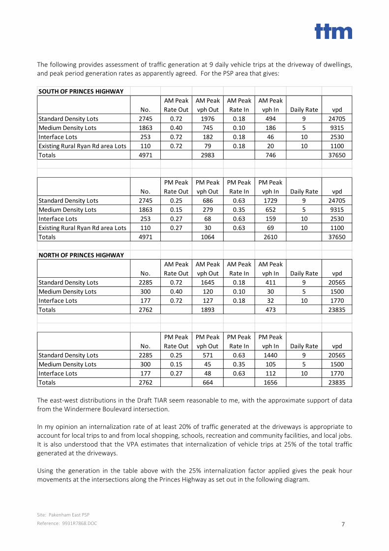
The following provides assessment of traffic generation at 9 daily vehicle trips at the driveway of dwellings, and peak period generation rates as apparently agreed. For the PSP area that gives:
The east‐west distributions in the Draft TIAR seem reasonable to me, with the approximate support of data from the Windermere Boulevard intersection. In my opinion an internalization rate of at least 20% of traffic generated at the driveways is appropriate to account for local trips to and from local shopping, schools, recreation and community facilities, and local jobs. It is also understood that the VPA estimates that internalization of vehicle trips at 25% of the total traffic generated at the driveways. Using the generation in the table above with the 25% internalization factor applied gives the peak hour movements at the intersections along the Princes Highway as set out in the following diagram.
SOUTH OF PRINCES HIGHWAY
No.
AM Peak
Rate Out
AM Peak
vph Out
AM Peak
Rate In
AM Peak
vph In Daily Rate vpd
Standard Density Lots 2745 0.72 1976 0.18 494 9 24705
Medium Density Lots 1863 0.40 745 0.10 186 5 9315
Interface Lots 253 0.72 182 0.18 46 10 2530
Existing Rural Ryan Rd area Lots 110 0.72 79 0.18 20 10 1100
Totals 4971 2983 746 37650
No.
PM Peak
Rate Out
PM Peak
vph Out
PM Peak
Rate In
PM Peak
vph In Daily Rate vpd
Standard Density Lots 2745 0.25 686 0.63 1729 9 24705
Medium Density Lots 1863 0.15 279 0.35 652 5 9315
Interface Lots 253 0.27 68 0.63 159 10 2530
Existing Rural Ryan Rd area Lots 110 0.27 30 0.63 69 10 1100
Totals 4971 1064 2610 37650
NORTH OF PRINCES HIGHWAY
No.
AM Peak
Rate Out
AM Peak
vph Out
AM Peak
Rate In
AM Peak
vph In Daily Rate vpd
Standard Density Lots 2285 0.72 1645 0.18 411 9 20565
Medium Density Lots 300 0.40 120 0.10 30 5 1500
Interface Lots 177 0.72 127 0.18 32 10 1770
Totals 2762 1893 473 23835
No.
PM Peak
Rate Out
PM Peak
vph Out
PM Peak
Rate In
PM Peak
vph In Daily Rate vpd
Standard Density Lots 2285 0.25 571 0.63 1440 9 20565
Medium Density Lots 300 0.15 45 0.35 105 5 1500
Interface Lots 177 0.27 48 0.63 112 10 1770
Totals 2762 664 1656 23835

Site: Pakenham East PSP
Reference: 9931R7868.DOC 8
10015
0
83050
203030
5020 130
1 5
70
250
RY
AN
RD
2 20
3 00
840100
137070
8030 280
3 0
120
440
ST
RE
ET
A
140
1 90
119050
101040
6020 250
40
100
320
ST
RE
ET
B
160
160
146050
77050
5020
200
4 0
70
180
ST
RE
ET
C
50S
TR
EE
T D
82015
3050
1850110
108070
10010 60
1 5
250
100
RY
AN
RD
9 01 00
1350220
950170
25020
140
370
200
ST
RE
ET
A
50110
1180130
1110110
20030 100
50
270
150
ST
RE
ET
B
5 050
990120
1270120
17040 80
20
220
100
ST
RE
ET
C
30S
TR
EE
T D
153040
108040 10
1090
20101810
PM PEAK HOUR
AM PEAK HOUR
20

Site: Pakenham East PSP
Reference: 9931R7868.DOC 9
7 Intersections along Princes Highway The exhibited material provides conceptual layout plans for the intersections along the Princes Highway. The council Draft TIAR proposes some minor changes to those intersections, providing a rationale based on SIDRA analysis of future traffic flows along both the Princes Highway and the intersecting streets. The council proposal for the intersections is to add a few left turn (generally high angle slip) lanes and to alter a few lane lengths. I agree with adding slip lanes for left turn exit from the streets within the precinct because it will allow through traffic smoother passage during off peak periods and there is no detrimental impact on pedestrian related conditions downstream. I recommend adding left slips at all connecting streets, even if only a very short approach lane length is applied. To review the validity of the proposals I am applying SIDRA analysis to the intersections, with the traffic loadings being per the diagram at Section 6 above, and the layout being per the diagram below.
The Lane Summary tables from the Sidra analysis are appended to this report and demonstrate adequate performance under the loadings applied. Of course if more realistic loadings were applied there would be a significantly greater margin of freedom in the outputs.

Site: Pakenham East PSP
Reference: 9931R7868.DOC 10
8 Traffic and Street Form for Internal Streets
8.1 Overview The exhibited material provides no guidance about traffic volumes on any sections of street other than on the approaches to the Princes Highway intersections. Consequently it is unclear as to what the nomination of the proposed street forms in the PSP has been based upon
8.2 Traffic on Major Streets at Princes Highway On the basis of the estimating rates set out at Section 6 my estimate of the distribution of daily vehicle movements on the major connections from the south is set out below.
These are less than in the council TIAR and demonstrate that there is no need for the increased cross sections as set out in the TIAR. With more appropriate traffic generation rate estimates the volumes would be much lower, but would not change what is built on the major street linkages. A street network planning objective should be to limit the extent of street where those traffic volumes will be so high. That is achievable through development of a well‐connected movement network, offering multiple route choices for most trips as the network approaches the links to the Princes Highway, and to the main “loop” arterial Connector Boulevard Street from Intersection A to Intersection B.
8.3 Traffic and Street Network Elements within the Neighbourhoods In the area east of Ryan Road and south of the Primary School site the PSP Plan 7 shows some Access Street Level 2 proposals. There is not enough developable land to create a need for those streets, with Access Street Level 1 being adequate. Additional parking around part of the school site may be warranted. There will be almost no traffic on the streets that run along the drainage areas, freeway corridor and open space areas. There should be a further street section ‐ Park Edge ‐ with 5.5 metres carriageway in a 12.5 metres reservation, as is contemplated for similar application in Clause 56.06 of the Planning Scheme. The proposed Boulevard Connector east of Street B can be a Connector Street, and the proposed Connector Street as Street B near the LTC can be Boulevard Connector. Streets along Hancock’s Gully are shown at Access Street Level 2, both sides. Those streets will have housing on only one side, and are not likely to carry more than 1,000 daily vehicle movements. A “Park Edge” form of Access Street Level 1 will be adequate. My proposed modifications to the street forms are shown in Drawing No. 9931110. The Conservation Interface Street will have extremely low traffic volumes and the carriageway width needs to be 5.5 metres, not more.
900
0
600
0
700
0
600
0

Site: Pakenham East PSP
Reference: 9931R7868.DOC 11
9 Cycling Trails and On‐Street Proposals The PSP shows a very comprehensive network of trails and cycle paths along some streets. AustRoads provides guidance on separation of cyclists from motor vehicles and also on appropriate grades, as follows.
Whilst the AustRoads Guide may indicate that there is no need for separation of cyclists from motor vehicles on some parts of the network I agree that where a logical route between points of attraction for cyclists will go along a street the separation is appropriate. A key point relates to gradients. On the proposed Boulevard Connector Street through the central part of the site there are grades of about 3.2% in 250 metres and 4.3% in 230 metres. A longitudinal section of the ground level along the proposed Bvd Connector Street near the High School site is provided in Drawing No. 9931501. That is not to say that the section provides finished levels but responsible design would reduce cuts and fills to limit environmental impact. Given that this is a virtual “greenfield” site I recommend a realignment of the street on which the path is proposed, to achieve grades that meet the “desirable” criteria provided by AustRoads. A suitable realignment is shown in the Drawing No. 9931310, affecting the PSP proposed High School site. I note the Parklea proposal to relocate the High School to a flatter location further to the north east, within an area likely to be delivered much later in the overall project. The Parklea proposal allows the Connector Street to have cycle‐friendly grades, is a better fit with the staging of the development and is also a better transport related solution for a major school. A further point about cycling facilities is that as far as is possible every street should be cycling‐friendly. Where target speeds are 40kph or lower, traffic volumes under about 2,500 vehicles per day will allow that if we accept the AustRoads guidelines.

Site: Pakenham East PSP
Reference: 9931R7868.DOC 12
10 The Parklea Alternative Future Urban Structure The Parklea Future Urban Structure Plan (FUS) varies from the exhibited FUS in that:
The Active Open Space has been split into two segments, with one moved east of Hancock’s Gully.
The Indoor Recreation, High School and non‐government Primary School have been moved to a relatively flat area east of Hancock’s Gully.
Community facilities adjacent to the LTC have been moved to east of Hancock’s Gully.
A small park east of the southern primary school has been omitted. Key transport related points about those matters are:
Access to the High School from the east is significantly improved. I note the secondary school catchment predictions provided by Mr. Panozzo, as follows.
From that information it is clear that the eastern area is of significance to the High School population.
Accessibility from areas west of the PSP is similar to that in the PSP proposed location because of the greater distance of Princes Highway use compared with Connector Street.
If the Parklea alternative is to be accepted I would alter some of the recommendations shown in Drawing No. 9931310 to provide more street with parking and clear travel paths. Drawing No. 9931311 shows the appropriate concept. The reason for the additional street network including clear travel lanes and additional parking is to enable satisfactory management of the school traffic, clear of parking and with circular travel paths enabled so that U‐turns are not prevalent. Under the proposal presented in Drawing No. 9931311 both the non‐government primary school and the secondary school have all boundaries along streets, and all except the western boundary of the primary school would be streets with two clear travel lanes plus parallel parking.

Site: Pakenham East PSP
Reference: 9931R7868.DOC 13
11 The Parklea Proposed LTC Plan Parklea has discussed an alternative town centre concept plan with the VPA and Council. The version assessed by me is appended to this report. I understand that, following a workshop session held in May 2018, modifications may be made to this concept plan. The Parklea LTC plan differs from the exhibited PSP plan for the LTC in respect of the alignment of the streets and the location of key intersections. The Parklea plan has a design that is sprung from a plan for Intersection B and the Connector Street, with a de facto “Main Street” intersection on Connector B about 110 metres south of the Princes Highway southern carriageway. The plan for the connector is shown in the drawing proposed by Cardno and appended to this report. As a presentation of the LTC the Street B form would be improved with a planted median, consistent with the Boulevard Connector Street form. The cycle path in a less formal response to the typical section may allow better integration of the traffic facilities with the existing trees that are to be retained in that vicinity.
12 Ryan Road Ryan Road is nominated as a “bus capable” street in the network. The PSP proposal is for a 7 metres carriageway plus 2 x parking/tree lanes, centred on a line offset 9.6 metres off one of the property boundary lines. The existing carriageway of about 7.5 metres width is located to the east of centre, approximately centred on a line about 9.5 metres off the eastern building line. That condition exists to a point about 300 metres south of Canty Lane, from where the pavement is unsealed. There is a narrowing at a drainage crossing north of Canty Lane.
South of the existing sealed carriageway a street carriageway of 7.3 metres will be adequate, with no additional parking needed. AADT will be under about 2,500. The paths can continue south on the PSP proposed offsets. Therefore Ryan Road will need minimal additional work – the paths can be provided with development and minimal indented car parking to service development as occurring. Any idea of making Ryan Road wider to the southern boundary in case a railway station might go there makes no sense. If a railway station had been proposed a totally different urban structure would be appropriate. In my opinion there is no need for a roundabout at the intersection of Canty lane and Ryan Road. A simple priority T junction will provide adequately for the movements that are likely to occur.

Site: Pakenham East PSP
Reference: 9931R7868.DOC 14
13 The Boulevard Connector Street as an Arterial Street The constraints to the arterial road network are such that there is no way of responding truly to the traditional “mile grid” of arterial roads or streets with midway connectors, despite what the VPA explanatory report says. Typically arterial blocks will encompass about 256 hectares of land, and connections are short and straight where “connector” street standards are warranted. In this case the area south of Princes Highway is about 370 hectares, or well over a full arterial street block. The Boulevard Connector Street will need to function as an arterial street – the network would fail if it was to be removed, which is a valid test of what constitutes an arterial network element.
14 The Infrastructure Contributions Plan
Key points in respect of traffic facilities included in the Infrastructure Contributions Plan (ICP) are:
With approach configurations to the Princes Highway per the council TIAR with left slips, and under the traffic volume scenario described above, 3 separate through lanes on the Princes Highway are not necessary and such layouts should not be part of the ICP.
The roundabout at the intersection of Canty Lane and Ryan Road is not necessary and therefore should be removed from the ICP.
Ryan Road should not be part of the ICP
The Boulevard Connector between Intersection A and Intersection B should be included in the ICP
15 Summary and Conclusions Subject to the recommendation made in the body of this statement I see no traffic or transport related reasons why the proposed Planning Scheme Amendment should not be adopted. Additional work will be needed in respect of the ICP, and I have made my recommendations in that respect in the body of the statement. In preparing this statement I have made all of the inquiries that I believe are desirable and appropriate and no matters of significance which I regard as relevant have to my knowledge been withheld from the Panel. TTM Consulting (Vic) Pty Ltd
J. D. Higgs

APPENDIX


RYA
N R
OA
D
MT A
RARA
T RO
AD
SOUT
H
MT A
RARA
T RO
AD
NO
RTH
DORE
RO
AD
OA
KVIE
W LA
NE
PRINCES FREEWAY
PRINCES HIGHWAY
PRINCES HIGHWAY(PROPOSED)
AOS1
AOS2
14 May 2018
PAKENHAM EASTLevel 2, 6 Riverside Quay Southbank, VIC 3006
t 9695 3025 f 9695 3001
N
1:8000 at A1
0 80 160 240 400METERS
1:16000 at A3Revised VPA FUSP - Option 1

SITE ANALYSIS SK06 (Option 2)
retail developmentsupermarket 4200 sqm(5.0 /100sqm) 210 cars
specialty retail 4685 sqm(5.0 /100sqm) 235 cars
commercial + medical 2550 sqm(3.5 /100sqm) 90 cars
childcare 1000 sqm(3.5 /100sqm) 35 cars
CAC 1200 sqm(3.5 /100sqm) 42 cars
total area 13635 sqm
total cars required 535 carscarpark a 350 carscarpark b 290 carsstreet parking tbc
total cars proposed 640 cars
new street to wrap around combined NAC & CAC sites
SYD
i 2 C . C O M . A U
MEL
PER1800 422 533
CONCEPT PLANNING 01.10.2015
2015-063DRAWN BY
DRAWING NO.
DATE
PROJECTPARKLEA
PAKENHAM EAST1:2000 @ A3
0 30m
MASTER PLAN OPTION 2
WO/BJ
SK06.11
[1:1000 @ A1]
supermarket4200 m2
r960
r300
r500
retail600medical
650
retail
medical1000
retail
retail
car park a350 cars
car park b200 cars
upper level residential over ground floor retail
50m creek offset line
multi level res.
750
c/p
town-houses
town-houses
town-houses
townhouses
feature building
park
school site
residential
residential
residential
residential
residential
residential
residential
residential
residential
residential
residential
view line
view line
residential
childcare
kinder
cac
outdoor
outdoor
town square
medium density
residential
medium density
residential
princes highway
view
line
comm.900
900
675
ha
nc
oc
k’ s
gu
l l y

SITE LAYOUT
Site: 101 [INT B PM ]


