traffic planning study
TRANSCRIPT

Project #: 43.4697
Traffic Planning Study
Broad Street Corridor Master Plan
Broad Street City of Rochester, New York
Monroe County
October, 2010
PREPARED FOR:
City of Rochester City Hall
30 Church Street Rochester, New York 14614
CONTACT:
Thomas Hack
PREPARED BY: T.Y. Lin International Engineering, Architecture & Land Surveying, PC 255 East Avenue Rochester, NY 14604 p. (585) 512-2000

Broad Street Corridor Master Plan – Rochester, NY Traffic Planning Study
October 2010
i
TRAFFIC PLANNING STUDY Broad Street Corridor Master Plan
Broad Street
City of Rochester, New York
TABLE OF CONTENTS
SECTION PAGE
EXECUTIVE SUMMARY 1
I. INTRODUCTION AND PROJECT DESCRIPTION 5
II. EXISTING STREET NETWORK GEOMETRY AND TRAFFIC VOLUMES 8
III. BACKGROUND DEVELOPMENT & ROADWAY NETWORK MODIFICATIONS 14
IV. TRAFFIC PROJECTIONS 15
V. TRAFFIC OPERATIONS 30
VI. PUBLIC TRANSPORTATION 35
VII. PARKING EVALUATION 38
VIII. CONCLUSIONS AND RECOMMENDATIONS 40
REFERENCES 43
APPENDIX A – Master Plan Conceptual Phased Layouts APPENDIX B – Calculations APPENDIX C – Level of Service Table & Level of Service Definitions APPENDIX D – Intersection Capacity Analysis Printouts APPENDIX E – Traffic Figures APPENDIX F – Trial Bridge Closure Traffic Counts and Observation Notes APPENDIX G – Sensor Data Graphs

Broad Street Corridor Master Plan – Rochester, NY Traffic Planning Study
October 2010
ii
TABLE, MAP, AND FIGURE SUMMARY
Table I-1 – Development Scenarios Table IV-1 – Intersection Level of Service - Broad Street Bridge Trial Closure Table IV-2 – Sensor Data Comparison: Broad Street Bridge Open vs. Broad Street Bridge Closed Table IV-3 –Full Buildout Unadjusted Traffic Generation (2025) Table IV-4 – Adjusted Full Buildout Traffic Generation (2025) Table IV-5 – Scenario 2 – 2014 Traffic Generation (35% of Full Development 2025) Table V-1 – Intersection Level of Service in the Study Area - Proposed Table VI-1 – Existing Public Transit Services Table VII-1 – Existing Study Area Parking Supply and Demand Map I-1 - Broad Street Corridor Study Area Map I-2 - Broad Street Recommended Alternative of the Master Plan Exhibit II-1 – Court Street @ South Avenue Exhibit II-2 – Court Street Typical Section (Exchange Boulevard to South Avenue) Exhibit II-3 – Exchange Boulevard (Court Street to Broad Street) Exhibit II-4 – Exchange Street Typical Section (Court Street to Broad Street) Exhibit IV-1 – Broad Street Aqueduct (North) Exhibit VIII-1 –Exchange Boulevard with Mitigation (Court Street to Broad Street) Exhibit VIII-2 – Court Street with Mitigation @ South Avenue
Appendix E Figure 1-1 Existing Lane Configuration Figure 1-2A Existing AM Peak Hour Volumes Figure 1-2B Existing PM Peak Hour Volumes Figure 2-1 Scenario 1 – 2011 – Proposed Lane Configurations Figure 2-2A Scenario 1 – 2011 – AM Background Volume Figure 2-2B Scenario 1 – 2011 – PM Background Volume Figure 2-3A Scenario 1 – 2011 – AM Redistributed Volume Figure 2-3B Scenario 1 – 2011 – PM Redistributed Volume Figure 2-4A Scenario 1 – 2011 – AM Diverted Volume Figure 2-4B Scenario 1 – 2011 – PM Diverted Volume Figure 2-5A Scenario 1 – 2011 – AM Cumulative Volume Figure 2-5B Scenario 1 – 2011 – PM Cumulative Volume Figure 2-6A Scenario 1 – 2011 – AM Peak Hour Future Volume Figure 2-6B Scenario 1 – 2011 – PM Peak Hour Future Volume Figure 2-7 Scenario 1 – 2011 – 2-Way Conversion of Broad Street Figure 3-1 Scenarios 2&3 – 2014 & 2025 – Proposed Lane Configurations Figure 3-2A Scenario 2 – 2014 – AM Background Volume

Broad Street Corridor Master Plan – Rochester, NY Traffic Planning Study
October 2010
iii
Figure 3-2B Scenario 2 – 2014 – PM Background Volume Figure 3-3 Scenario 2 – 2014 – Background Development Distribution Figure 3-4A Scenario 2 – 2014 – AM 35% of Total Trip Distribution Volume Figure 3-4B Scenario 2 – 2014 – PM 35% of Total Trip Distribution Volume Figure 3-5A Scenario 2 – 2014 – AM 35% Redistribution w/ Watered Washington Street Figure 3-5B Scenario 2 – 2014 – PM 35% Redistribution w/ Watered Washington Street Figure 3-6A Scenario 2 – 2014 – AM Peak Hour 35% Build Volume Figure 3-6B Scenario 2 – 2014 – PM Peak Hour 35% Build Volume Figure 4-1A Scenario 3 – 2025 – AM 100% Total Trip Dist. w/ Watered Washington Street Figure 4-1B Scenario 3 – 2025 – PM 100% Total Trip Dist. w/ Watered Washington Street Figure 4-2A Scenario 3 – 2025 – AM 100% Total Development Distribution Figure 4-2B Scenario 3 – 2025 – PM 100% Total Development Distribution Figure 4-3A Scenario 3 – 2025 – AM Full Build Volume Figure 4-3B Scenario 3 – 2025 – PM Full Build Volume Figure 5 RTS Bus Routes within Study Area Figure 6 Off-Street Parking Figure TBC–1A Test Bridge Closure – 2010 AM Peak Hour Volumes Figure TBC–1B Test Bridge Closure – 2010 PM Peak Hour Volumes Figure TBC–2A Test Bridge Closure –2010 AM Peak Hour Volumes (Grown to 2011) Figure TBC–2B Test Bridge Closure – 2010 PM Peak Hour Volumes (Grown to 2011) Figure TBC–3A Test Bridge Closure – 2008 AM Peak Hour Volumes (Grown to 2011) Figure TBC–3B Test Bridge Closure – 2008 PM Peak Hour Volumes (Grown to 2011) Figure TBC- 4A Test Bridge Closure – 2010 AM Peak Hour Volumes (Grown to 2011) – Change
in Traffic Volume Figure TBC–4B Test Bridge Closure – 2010 PM Peak Hour Volumes (Grown to 2011) - Change
in Traffic Volume
Broad Street Corridor Master Plan – Rochester, NY Traffic Planning Study
October 2010
1
EXECUTIVE SUMMARY The City of Rochester is proposing to redevelop the Historic Erie Canal Aqueduct and the Broad Street Corridor between South Avenue and westerly to the Main Street intersection, across the Genesee River, in the City of Rochester, Monroe County, New York. The project study area is defined as the geographic area bounded by Main Street to the north, the Inner Loop to the south and west, and Clinton Avenue to the East. To revitalize the area and spur development the project, as recommended in the Master Planning process is composed of the following three geometric modification construction phases:
• Phase 1 – Involves closing the Broad Street Bridge over the Genesee River and rewatering the former aqueduct. Anticipated to begin construction in 2011 and be completed by 2012.
• Phase 2 – Conversion of the section of Broad Street between South Washington Street and Exchange Boulevard into a boulevard with one (1) travel lane in each direction and adjacent parking. Phase 2 is assumed to begin soon after phase 1 and be completed by 2013.
• Phase 3 - Involves closing and watering the street section between Washington Avenue and Main Street. Construction is planned to occur 2013 to 2014
Future development of this land is anticipated and was analyzed by Economics Research Associates (ERA). Their analysis was based on four uses: retail, office, hotel, and residential. Based on three phases of development, the following traffic scenarios were analyzed:
• Scenario 1 - Phase 1 construction without any of the vacant land use development.
• Scenario 2 – Includes the completed three-phase construction of Broad Street and about 35% of the development of the adjacent vacant land.
• Scenario 3 – Includes the evaluation of the full development of vacant land in the study area targeted to be complete by the year 2025.
EXISTING STREET NETWORK GEOMETRY AND TRAFFIC VOLUMES Monroe County DOT maintains two databases that contain traffic volume numbers; one database is comprised of street segments and the other one is based on intersection turning movement counts at intersections. These two databases contain traffic count information ranging from the early 1980’s to the current year. The traffic counts included in this study represent the most current data collected for the respective street segment or intersection. To evaluate the impact of this project on the adjacent city street network, twenty-seven (27) signalized intersections were studied within the study area.
Broad Street Corridor Master Plan – Rochester, NY Traffic Planning Study
October 2010
2
BACKGROUND DEVELOPMENT & ROADWAY NETWORK MODIFICATIONS Background developments currently planned or recently constructed in the core downtown area that would likely impact the study area were added to the existing traffic volumes to project future background traffic volumes. The following major developments were included in the background analysis for Scenario 2 (2014, 35% build):
• Construction of PAETEC Headquarters/Midtown Redevelopment in the Main Street/North Clinton Avenue/Chestnut Street/Broad Street area;
• Recently constructed ESL Headquarters in the Chestnut Street/Woodbury Street area;
• The Transit Center at Mortimer Street. Additionally, the City has several initiatives planned for street network modifications within the downtown core corresponding to the developments listed above. These proposed street changes include:
• Conversion of Broad Street from a one-way street to a two-way street between Stone Street and Broadway Street east of the study area. This improvement is anticipated to be complete by 2011 and has been incorporated into the study.
• Modification of a portion of the Inner Loop from a grade-separated expressway with frontage roads to a multi-lane arterial between the Monroe Avenue/Chestnut Street area and Main Street. This modification has not been incorporated into the study.
TRAFFIC PROJECTIONS The projected traffic for the project area is comprised of several distinct components and derived from different modeling approaches. These components are listed as follows:
1. Existing traffic within the study area and the core downtown area 2. Background traffic for major developments listed in section III 3. The use of the Genesee Transportation Council’s Travel Demand Model 4. Annual growth factor for background traffic 5. Redistribution and diversion of traffic from the Broad Street Bridge closure for
the Phase 1 construction (as supported by the Mock Bridge Closure ) 6. Traffic generated for the projected Broad Street Corridor Master Plan
development 7. Trip generation reduction factors and distribution of Scenario 2 (2014) traffic –
assumed to be 35% of the project development 8. Trip generation reduction factors and distribution of Scenario 3 (2025) traffic–
assumed to be 100% of the project development These components are discussed further in the Traffic Impact Study (TIS).

Broad Street Corridor Master Plan – Rochester, NY Traffic Planning Study
October 2010
3
TRAFFIC OPERATIONS Using the network model provided by Monroe County Department of Transportation (MCDOT), the studied intersections were analyzed with the traffic-software Synchro 7 build 761 to determine the signalized Levels of Service (LOS). The intersection LOS was compared for each of the locations studied for the existing condition and each of the three scenarios outlined above for the weekday morning and evening peak hours. PUBLIC TRANSPORTATION Within the study area, a total of 34 bus routes currently pass through the study area. Of the three river crossings, Main Street receives the highest volumes of bus traffic (in both directions), while Broad Street receives only westbound traffic and Court Street receives only eastbound traffic. Downtown Rochester is the hub for the Regional Transit Service (RTS) bus system. As such, the impact of bus service on the study area is investigated in this report.
CONCLUSIONS AND RECOMMENDATIONS The proposed Broad Street Corridor Master Plan recommended alternative includes closing the Broad Street Bridge to rewater the aqueduct, converting Broad Street to a boulevard with one lane in each direction and adjacent parking from Exchange to South Washington, and closing the section of Broad Street between South Washington Street and West Main Street to rewater this area. To mitigate the intersections that would have a Level of Service of E or F under the scenarios studied, the following physical improvements are proposed:
SCENARIO 1 MITIGATION (2011, Bridge Closure) Restripe the Court Street roadway section between Exchange Boulevard and
South Avenue to provide; one lane westbound with two westbound lanes on the west end of the section and two eastbound lanes with parking on the south side transitioning to three eastbound lanes on the east end of the section.
At the intersection of Court Street with South Avenue, modify the westbound approach lane geometry from a left/through and through to an exclusive left and one through lane.
On Exchange Boulevard between Broad Street and Court Street, restripe the inside southbound lane as a left only and then the curb lane would be the through lane. The northbound left turn lane would be extended towards Court Street providing side-by-side turn lanes to increase storage capacity for these two left turn movements.
SCENARIO 2 MITIGATION (2014, 35% Development)
On Main Street at Washington Street and Plymouth Ave, widen and restripe Main Street between the I-490 overpass and Fitzhugh Street to provide opposing left turns on Main Street (a five lane section) and remove parking
Broad Street Corridor Master Plan – Rochester, NY Traffic Planning Study
October 2010
4
from the south side of the street. In addition, at the intersection of Main Street with Plymouth Avenue, modify the traffic signal operation to provide a protected/permitted left turn phase for each approach.
On Main Street from Exchange Boulevard/State Street to East Avenue, maintain the current four lane section with the removal of the exclusive bus lanes. This is necessary to support for the 35% development phase (2014) when the section of Broad Street is proposed to be closed west of Washington Street.
On Exchange Boulevard at Broad Street, modify the traffic signal operation to provide a protected/permitted northbound left turn phase.
Optimization of traffic signals timings are recommended where necessary.
SCENARIO 3 MITIGATION (2025, Full Development) At the intersection of Main Street with Plymouth Avenue, add a right-turn at
the westbound approach. Reverse the direction of Troup Street between South Fitzhugh Street and
South Plymouth from one-way EB to one-way WB. Construct an additional connection for westbound traffic on Troup street between Exchange Boulevard and Plymouth Avenue, which is currently one-way eastbound in this section. This connection will provide alternative access for the Court/Exchange area to the I-490 eastbound from the Plymouth Avenue on-ramp, without crossing the river via Court Street. Modify the Plymouth/Troup signal to add WB heads and loops.
Optimization of traffic signals timings will be needed to adjust for revised geometries and traffic patterns.
Additionally, the changes in on-street parking within the study area for this project would be a net loss of 130 spaces, a loss of 107 within the Broad Street corridor, a loss of 24 in the Main Street corridor and a net gain of 1 space in the Court Street corridor. However, the net increase of 435 planned off-street parking will provide an overall net gain of 328 spaces in parking supply within the study area.

Broad Street Corridor Master Plan – Rochester, NY Traffic Planning Study
October 2010
5
I. INTRODUCTION AND PROJECT DESCRIPTION Rochester’s Center City Core (roughly defined as the area within the Inner Loop, as well as High Falls, a portion of Corn Hill, and the East End to Alexander Street) has been experiencing resurgence in recent years. Various Center City districts, including the East End, Grove Place, and the St. Paul Quarter have benefited from an increase in residential units in the form of both new construction, and the renovation of existing historic buildings. In addition, the ESL Headquarters has been completed and the Midtown Redevelopment Project and the Transit Center are moving forward amid other smaller development projects to add to the revitalization of the core downtown area east of the Genesee River. The southwest quadrant of Center City (south of Main Street and west of the Genesee River), has yet to see any type of private investment. The Historic Erie Canal Aqueduct and Broad Street Corridor Master Plan was spearheaded by the City of Rochester in an effort to provide a planning initiative for the city blocks immediately north and south of Broad Street from South Avenue to the Broad Street intersection at Main Street. A primary goal of the master plan was to determine a best possible reuse for the historic Erie Canal Aqueduct, which allows Broad Street to span the Genesee River by carrying the road deck for the Broad Street Bridge. The study area is shown below in Map I-1.
Map I-1 - Broad Street Corridor Study Area
Broad Street Corridor Master Plan – Rochester, NY Traffic Planning Study
October 2010
6
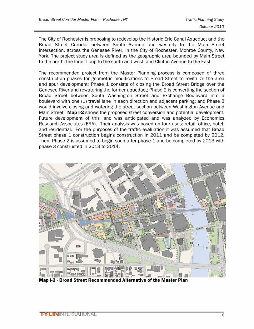
The City of Rochester is proposing to redevelop the Historic Erie Canal Aqueduct and the Broad Street Corridor between South Avenue and westerly to the Main Street intersection, across the Genesee River, in the City of Rochester, Monroe County, New York. The project study area is defined as the geographic area bounded by Main Street to the north, the Inner Loop to the south and west, and Clinton Avenue to the East. The recommended project from the Master Planning process is composed of three construction phases for geometric modifications to Broad Street to revitalize the area and spur development; Phase 1 consists of closing the Broad Street Bridge over the Genesee River and rewatering the former aqueduct; Phase 2 is converting the section of Broad Street between South Washington Street and Exchange Boulevard into a boulevard with one (1) travel lane in each direction and adjacent parking; and Phase 3 would involve closing and watering the street section between Washington Avenue and Main Street. Map I-2 shows the proposed street conversion and potential development. Future development of this land was anticipated and was analyzed by Economics Research Associates (ERA). Their analysis was based on four uses: retail, office, hotel, and residential. For the purposes of the traffic evaluation it was assumed that Broad Street phase 1 construction begins construction in 2011 and be completed by 2012. Then, Phase 2 is assumed to begin soon after phase 1 and be completed by 2013 with phase 3 constructed in 2013 to 2014.
Map I-2 - Broad Street Recommended Alternative of the Master Plan

Broad Street Corridor Master Plan – Rochester, NY Traffic Planning Study
October 2010
7
The first traffic analysis scenario, Scenario 1, is Phase 1 construction without any of the vacant land use development. The remaining construction phases, Phase 2 and 3, converting Broad Street to match the master plan is assumed to be complete by 2014 coinciding with completion of other downtown development projects outside of the Broad Street Aqueduct Master Plan study area but within the core downtown area. Scenario 2 consists of the completed three-phase construction of Broad Street and about 35% of the development of the adjacent vacant land. This 35% development is assumed to occur in the area of the rewatered aqueduct along South Avenue on the east side of the river and Exchange Boulevard on the west side of the river since this area is the focal point of the development area. Full land use development is forecasted to occur over a 15 year window beyond 2011, so the last scenario, Scenario 3, is the evaluation of the full development of vacant land in the study area targeted to be complete by the year 2025. Table I-1 correlates the development scenarios and the Broad Street construction phases.
Table I-1 Development Scenarios
Scenario No. (Year)
Planned Development
Completed Broad Street Construction Phase
1 (2011) 0%
Phase 1 Construction complete- Broad Street closed between South Ave and Exchange Blvd – Begin Construction of Aqueduct section (2011-2012) – Includes 2-way conversion of Broad Street within and adjacent to the study area
2 (2014) 35%
Phase 2 Construction - Improve Broad Street into a “Boulevard” between Exchange Blvd and South Washington Street (2012-2013)
Phase 3 Construction - Broad Street between Washington Street and Main Street – Canal Watering (2013-2014)
3 (2025) 100% Broad Street Construction Phases completed

Broad Street Corridor Master Plan – Rochester, NY Traffic Planning Study
October 2010
8
II. EXISTING STREET NETWORK GEOMETRY AND TRAFFIC VOLUMES The following is a description of the current City streets and intersections within the study area. Traffic volumes are collected by Monroe County DOT and maintained in two databases; one database for street segments and the other one for intersection turning movement counts at intersections; and the corresponding date of the counts. These two databases contain traffic count information ranging from the early 1980’s to the current year. The traffic counts included in this study represent the most current data collected for the respective street segment or intersection. A comparison of the downtown street segments volume data over the last 30 years shows that downtown traffic volumes are cyclical with increases and decreases over the time frame. However, the traffic volumes have not significantly grown over that time period and for this reason, the latest intersection count data is assumed to be the “Existing 2008” traffic volumes for use in this report. The speed limit for all of these streets is 30 mph. The existing lane configurations are shown in Figure 1-1 and the existing AM and PM total volumes are shown in Figures 1-2A and 1-2B, respectively. Broad Street Broad Street is an urban minor arterial that traverses east-west and consists of two travel lanes in each direction all the way from West Main Street thru Stone Street where it becomes one way westbound. Traveling East on Broad Street there are left turn lanes at the intersections of South Plymouth Avenue, South Fitzhugh Street, Exchange Boulevard and Stone Street. Traveling west there are left turn lanes at the intersection of Stone Street, South Avenue, Exchange Boulevard, South Fitzhugh Street, South Plymouth Street, and South Washington Street. On-street parking is available on both sides of the street between the Main Street and Stone Street intersections. The Average Daily Traffic (ADT) varies between approximately 8,200 (near Washington Street) to 11,600 (near South Avenue) vehicles per day (vpd) and the bidirectional Peak Hour Volume (PHV) varies between 1,000 to 1,200 vehicles per hour (vph). Main Street Main Street is an urban minor arterial that traverses east-west in the downtown area and consists of four lanes, two traveling in each direction between Clinton Street and Aqueduct Street intersections. Left turns are restricted in both directions at Clinton Street between 7:30am and 6:00pm, Monday through Friday. West of Aqueduct Street, Main Street transitions to a six lane arterial, three lanes in each direction with parking allowed in the curb lane off-peak hours. Traveling east there are left turn lanes between Aqueduct Street and the Clarion Riverside Hotel Entrance west of the South Avenue intersection. The center left turn lane becomes a through lane west of Aqueduct Street and left turns are restricted at the intersection of State Street/Exchange Boulevard. Three lanes continue westbound with the auxiliary opposing left turn lanes at Fitzhugh Street. The three lanes in the eastbound direction drops to two lanes at Fitzhugh Street where the inside lane becomes a left turn lane. Then two lanes continue eastward at this point. There is also a right turn lane marked at the intersection of South Plymouth Avenue. Shared bus lanes begin at Fitzhugh Street and continue eastward through the

Broad Street Corridor Master Plan – Rochester, NY Traffic Planning Study
October 2010
9
Clinton Avenue intersection to Chestnut Street. The ADT is approximately 17,000 vpd and the PHV is 1,300 vph. Court Street Court Street is an urban minor arterial that traverses east-west, runs from Exchange Blvd thru Clinton Avenue and beyond. On-street parking is available on both sides of the street between the Exchange Boulevard and South Avenue intersections with restrictions at each end to accommodate right turn lanes at the intersections. Court Street is one-way eastbound east of Clinton Avenue. The ADT is approximately 8,000 vpd and the PHV is 800 vph.
Exhibit II-1 – Court Street @ South Ave
Exhibit II-2 – Court Street Typical Section (Exchange Boulevard to South Ave) South Avenue / St Paul Street South Avenue / St Paul Street is an urban minor arterial that traverses one-way southbound to the south of E. Main Street in the downtown area. South Avenue consists of four travel lanes with an exclusive left-turn lane approaching the South Avenue Garage entrance and approaching East Broad Street. On-street parking is available between bump-outs in the area in front of the library. The ADT is approximately 23,000 vpd and the PHV is 2,010 vph. Plymouth Avenue Plymouth Avenue is an urban principal arterial street that traverses north-south, from W. Main Street northerly and southerly. There are left turn lanes heading north and south

Broad Street Corridor Master Plan – Rochester, NY Traffic Planning Study
October 2010
10
at the intersections of W. Main Street and W. Broad Street, and ending at the south entrance to the Civic Center. The ADT is approximately 11,000 vpd and the PHV is 1,000 vph. Spring Street Spring Street is classified as an local street and is a two-lane, one-way street eastbound between South Washington Avenue and South Plymouth Street and a two-lane, one-way street westbound between South Washington Avenue and West Broad Street. No on-street parking is provided. The ADT is approximately 5,000 vpd and the PHV is 400 vph. Exchange Boulevard/State Street Exchange Boulevard is an urban minor arterial that traverses north-south, from West Main Street southerly. There are left turn lanes heading south at West Broad Street, Court Street, and the Blue Cross Arena parking lot just south of the Court Street intersection. Traveling north there is a left turn lane at the intersection of West Broad Street. At the intersection of Main Street left turns are prohibited from 7:30am to 6:00pm Monday – Friday. On-street parking is available on both sides of the street between the South Fitzhugh/Troup Street and West Main Street intersections with bump-outs defining parking areas with some restrictions near the Blue Cross Arena and the Public Safety Building. The ADT is approximately 13,500 vpd and the PHV is 1,100 vph.
Exhibit II-3 Exchange Boulevard
(Court Street to Broad Street)
Exhibit II-4 –Exchange Boulevard Typical Section (Court Street to Broad Street)
Broad Street Corridor Master Plan – Rochester, NY Traffic Planning Study
October 2010
11
Troup Street Troup Street is classified as a local street and is a one-lane, east-west street that is designated one-way in the eastbound direction between South Plymouth Avenue and South Fitzhugh Street/Exchange Boulevard area. The ADT is approximately 2,800 vpd and the PHV is 260 vph. Washington Street Washington Street is classified as an urban minor arterial and is a three-lane, north-south street with two lanes in the northbound direction and one-lane southbound between West Main Street and Spring Street. On-street parking is available on the west side of the street between the Spring Street and West Main Street intersections. South of Spring Street is the two-lane, one-way northbound I-490 westbound off-ramp to West Broad Street via Washington Street or South Plymouth Avenue via Spring Street. The ADT is approximately 12,000 vpd and the PHV is 900 vph. Fitzhugh Street Fitzhugh Street is classified as an urban principal arterial a two-lane, north-south street with one lane in each direction. On-street parking is available on both sides of the street between the West Broad Street and West Main Street intersections. The section south of West Broad Street is the access entrance to the Civic Parking garage. The ADT is approximately 5,000 vpd and the PHV is 400 vph. North/South Clinton Avenue North/South Clinton Avenue is an urban minor arterial that traverses one-way northbound south of E. Main Street in the downtown area. South Clinton Avenue consists of four travel lanes south of Broad Street with an exclusive right-turn lane approaching the Court Street intersection and an exclusive left-turn lane with a shared left-through lane approaching the Broad Street intersection, and parking available on the west side South of Court Street. North of Broad Street, South Clinton Avenue consists of three travel lanes with parking on the west side of the street. At the intersection of South Clinton Avenue and E. Main Street, turning movements are prohibited from 7:30am to 6:00pm, Monday through Friday. The ADT is approximately 20,000 vpd at the Court Street intersection and about 13,000 at Main Street. The PHV is 2,400 vph and 1,200 vpd at the Court Street and Main Street intersections, respectively. Chestnut Street Chestnut Street between Main Street and Monroe Avenue (south of Woodbury Boulevard) is classified as an urban minor arterial and is a four-lane, north-south street with two lanes in each direction. An additional southbound lane is provided between Court Street and Monroe Avenue. No on-street parking is available. The ADT is approximately 14,000 vpd and the PHV is 1300 vph.

Broad Street Corridor Master Plan – Rochester, NY Traffic Planning Study
October 2010
12
Woodbury Boulevard Woodbury Street is classified as an urban collector that traverses east-west, runs between South Avenue and Chestnut Street. On-street parking is available on both sides of the street between the S. Clinton Avenue and South Avenue intersections. The ADT is approximately 7,000 vpd and the PHV is 700 vph. Stone Street Stone Street is classified as a local street and is a two-lane street that traverses north-south between Main Street and Broad Street. Traffic is two-way south of the South Avenue parking garage access, and one-way northbound north of the South Avenue parking garage access. On-street parking is provided on the east side of the street. The ADT is approximately 4,000 vpd and the PHV is 450 vph. Bausch and Lomb Place Bausch and Lomb Place is classified as a local street that traverses north-south between Broad Street and Court Street. From Broad street, the street is one-way southbound to the circle in front of the Bausch and Lomb Tower that jogs easterly to align with St. Mary’s Place. The Court Street garage has access to this street. On-street parking is provided in the one-way section on the west side of the street. The ADT is approximately 4,000 vpd and the PHV is 450 vph. Saint Mary’s Place Saint Mary’s Place is classified as a local street and is a two-lane street that traverses north-south between Court Street and Capron Street. On-street parking is provided on both sides of the street. The ADT is approximately 4,000 vpd and the PHV is 450 vph. Washington Street, Plymouth Avenue, Fitzhugh Street, and Clinton Avenue are prefaced by “North” north of West Main Street and “South” South of West Main Street. Main Street and Broad Street have the East and West prefix on each side of the Genesee River. There are twenty-seven (27) signalized intersections within the study area that were analyzed to evaluate the impact of this project. The intersections within the study area include:
1. Main Street/Broad Street/Ford Street 2. Main Street/Broad Street 3. Main Street/Washington Street 4. Main Street/Plymouth Avenue 5. Main Street/Fitzhugh Street 6. Main Street/Exchange Blvd/State Street 7. Main Street/South Avenue/St. Paul Street 8. Main Street/S. Clinton Avenue/N. Clinton Avenue 9. Broad Street/Washington Street 10. Broad Street/Plymouth Avenue 11. Broad Street/Fitzhugh Street 12. Broad Street/Exchange Boulevard

Broad Street Corridor Master Plan – Rochester, NY Traffic Planning Study
October 2010
13
13. Broad Street/South Avenue 14. Broad Street/Stone Street 15. Broad Street/S. Clinton Avenue 16. Broad Street/Chestnut Street 17. Spring Street/Plymouth Avenue 18. Troup Street/1-490 EB On-Ramp/Plymouth Avenue 19. Court Street/Exchange Boulevard 20. Court Street/South Avenue 21. Court Street/Bausch & Lomb Place 22. Court Street/S. Clinton Avenue 23. Court Street/Chestnut Street 24. Woodbury Boulevard/South Avenue/I-490 25. Woodbury Boulevard/St. Mary’s Street 26. Woodbury Boulevard/S. Clinton Avenue 27. Woodbury Boulevard/Chestnut Street

Broad Street Corridor Master Plan – Rochester, NY Traffic Planning Study
October 2010
14
III. BACKGROUND DEVELOPMENT & ROADWAY NETWORK MODIFICATIONS
A. PROPOSED MAJOR DEVELOPMENTS
There are many developments that are planned in the core downtown area with three major developments occurring that are expected to add measureable traffic volumes to the downtown street network: PAETEC Headquarters/Midtown Redevelopment in the Main Street/North
Clinton Avenue/Chestnut Street/Broad Street area. This development continues to evolve in size and use. The forecasted volumes included in this study are for a larger development and are conservative compared to the current downsized scenario.
ESL Headquarters in the Chestnut Street/Woodbury Street area. Although this development has opened, the traffic volumes were generated based on the forecasted volumes.
The Transit Center at Mortimer Street. This is the remaining remnant of the former Renaissance Square project. This project will move the transit stopovers and dwell locations off Main Street to the Transit Center. Then the Main Street dedicated bus lanes can be removed to provide two lanes in each direction, which will provide additional traffic capacity if the Broad Street Bridge is closed.
For the purpose of this Traffic Study, It is assumed that the background developments are in place for the Scenario 2 (2014, 35% build).
B. PROPOSED STREET GEOMETRY OUTSIDE OF PROJECT AREA
The City has several initiatives planned for street network modifications within the downtown core corresponding to the developments listed above. These proposed street changes include:
Conversion of Broad Street from a one-way street to a two-way street between Stone Street and Broadway Street east of the study area. This improvement is anticipated to be complete by 2011 and has been incorporated into the study.
Modification of a portion of the Inner Loop from a grade-separated expressway with frontage roads to a multi-lane arterial between the Monroe Avenue/Chestnut Street area and Main Street. This modification has not been incorporated into the study.
Broad Street Corridor Master Plan – Rochester, NY Traffic Planning Study
October 2010
15
IV. TRAFFIC PROJECTIONS The projected traffic for the project area is comprised of several distinct components and derived from different modeling approaches. These components are listed as follows:
1. Existing traffic within the study area and the core downtown area. 2. Background traffic for major developments listed in section III. 3. The use of the Genesee Transportation Council’s Travel Demand Model. 4. Annual growth factor for background traffic. 5. Redistribution and diversion of traffic from the Broad Street Bridge closure for
the Phase 1 construction (as supported by the Mock Bridge Closure.) 6. Traffic generated for the projected Broad Street Corridor Master Plan
development. 7. Trip generation reduction factors and distribution of Scenario 2 (2014) traffic –
assumed to be 35% of the project development. 8. Trip generation reduction factors and distribution of Scenario 3 (2025) traffic–
assumed to be 100% of the project development. These components are discussed below showing the data source and the methodology for the application of the component to the overall traffic projections and evaluation of traffic impacts on the study area intersections. Calculation spreadsheets are included in Appendix B.
A. BASE TRAFFIC VOLUMES As discussed in Section II, the existing intersection turning movement count data for the downtown street network was taken over several years, however with cyclical changes in the City’s traffic patterns over the last thirty years, the most current count data from the MCDOT database was used without adjusting the traffic to the current year. These volumes were the basis for the existing 2008 base year traffic analysis. The MCDOT also made available the Synchro Traffic analysis model that includes these same existing volumes. This model was modified to match street geometry and signal operations to the study area intersections and street segments.
B. BACKGROUND TRAFFIC FOR MAJOR DEVELOPMENTS
Monroe County DOT has taken the traffic projections from the traffic studies prepared for the Transit Center (approximated from the former Renaissance Square project), Midtown Redevelopment and ESL Headquarters developments and prepared a spreadsheet appended to the existing intersection traffic database to show traffic associated with these developments including the roadway changes associated with them listed in the previous section. This information has been made available for use on this project and incorporated as appropriate.

Broad Street Corridor Master Plan – Rochester, NY Traffic Planning Study
October 2010
16
C. TRAVEL DEMAND MODEL
The Genesee Transportation Council (GTC) created a traffic model using the GTC Regional Travel Demand TransCAD model representing the existing year 2008 travel demand for AM and PM peak hours in downtown Rochester. They also prepared a future year 2014 travel demand model to include changes in the network demand based on specific developments for the downtown area including the Transit Center (former Renaissance Square), PAETEC Headquarters/ Midtown Redevelopment, and ESL Headquarters. The model also included some minor developments including Charlotte Square Development, Capron Street Development, Cox Building Development, Warner Place and the Kirstein Building Development. A 2014 travel demand model run named “Revised 2” included the proposed developments and street geometry changes since this is the anticipated timeframe for the completion of these projects. A second 2014 model was created that removed the link representing the Broad Street Bridge closure but included the proposed street geometry and development and this model is referred to as “Full Build 2” for the AM and PM Peak Hours.
D. ANNUAL GROWTH FACTOR
Based on the comparison of volumes between the 2008 “Existing” model and the 2014 “Revised 2” models, a growth rate of 0.5% was used for the study area background growth.
E. BROAD STREET BRIDGE CLOSURE PROJECTED TRAFFIC REDISTRIBUTION
AND DIVERSION The “Revised 2” and “Full Build 2” travel demand model runs were examined to assess the impact of the proposed closure of Broad Street Bridge over the Genesee River, Scenario 1. These model projections were used to gauge the anticipated traffic shifts that could be expected for all of the forecasted development within the downtown area for both scenarios with the Broad Street Bridge in place and with this bridge link removed. The proposed lane configuration for Scenario 1 is shown in Figure 2-1. The proposed 2011 peak hour volumes are shown in Figures 2-6A and 2-6B for AM and PM peak hours, respectively. However, since these models do not incorporate future land use for the proposed development in our study area, the model differences were used to determine the traffic redistribution for the bridge closure only. The “Revised 2” and “Full Build 2” model runs were compared at a cordon line located along the river bisecting the four bridge crossings within downtown. The volumes from the “Revised 2” model on the four bridges (Andrews Street, Broad Street, Main Street and Court Street) were compared to the directional model volumes if the Broad Street bridge were to be closed to traffic and shifted to the 3 remaining bridges (Court Street, Main Street and Andrews Street).

Broad Street Corridor Master Plan – Rochester, NY Traffic Planning Study
October 2010
17
This comparison yielded that 20% of trips currently crossing Broad Street would be diverted away from the remaining three CBD crossings and the remaining 80% would be redistributed trips that would use the three downtown crossings for both the AM and PM Peak time frames. The percentages of the model volumes representing redistributed trips were applied to the traffic volumes in the Synchro model. Therefore, in both the AM and PM, 80% of Broad Street traffic was redistributed to the other 3 bridges and the other 20% was diverted out of the study area. The comparison further identified that the closure of the Broad Street Bridge will shift 65% of the westbound directional Broad Street traffic to Court Street. That is 65% of 625 vph in the AM Peak and 65% of 850 vph in the PM Peak diverted to Court Street in both the AM and PM peak hours. Similarly, 10% and 15% of the Broad Street volumes would be redistributed to Main Street for the AM and PM peak hours, respectively. For eastbound traffic, the split was the similar and opposite, where 65% of the eastbound directional Broad Street traffic (65% of 500 vph in the AM and of 535 vph in the PM) diverted to Main Street in both the AM and PM peak hours and 10% to Court Street for both the AM and PM peak hours. Andrews Street will see 5% of the volume for both the EB and WB directions in the AM peak hour and 5% for the eastbound direction in the PM peak hour. Therefore, the peak two-way traffic on Main Street could grow to 1800 vph, Court Street to 1400 vph, and Andrews Street to 650 vph. Figures showing the redistributed traffic and the diverted traffic for the AM and PM peak hours are included in Appendix ‘E’. Although this may seem counter-intuitive, the model seems to generalize the diversion based on the destinations, which may be the concentration of businesses, parking garages and parking areas. That is, westbound traffic destined for areas north and west of Main Street west of the river will use Court Street in the AM and then eastbound Main Street in the PM. For the westbound AM traffic destined for areas south and east of Broad Street on the east side of the Genesee River indicate that traffic using Broad Street to cross in the AM peak may use Main Street in the AM and Court Street in the PM. This would correspond to the diversion assumptions in the model. The trial bridge closure described below supports the assumptions made for Scenario 1. The proposed traffic volumes were assigned to the revised street network using the directional turning movements of the Broad Street traffic through the network based on the MCDOT Synchro model.
F. TRIAL BRIDGE CLOSURE DATA COLLECTION In order to better understand the traffic impacts if the bridge was permanently closed, the Broad Street Bridge was closed for a two week trial period to observe traffic patterns within the city. The bridge was blockaded from the morning of
Broad Street Corridor Master Plan – Rochester, NY Traffic Planning Study
October 2010
18
Monday, February 15th, 2010 to 6:00pm Thursday, February 25th, 2010. The week of February 15th through the 19th, traffic was only moderately observed. The first week was assumed to have irregular traffic patterns as commuters were learning to adjust their normal trip in and out of the city. Also, Monday February 15 was a national holiday with most businesses closed, and with the public schools on recess for February Break through the remainder of the week, expected commuter and school traffic was anticipated to be reduced. Traffic observations and counts were conducted the second week of the bridge closure, as commuters were acquainted with new traffic patterns. Manual turning movement counts were conducted at various intersections in the study area February 23rd through February 25th during the morning and evening peak hours. Although the traffic data does not appear to have been impacted, a snow storm event occurred in the City the afternoon of Thursday February 25th, which caused traffic delays on area highways such as route I-490. This weather event may have caused commuters to leave work early, or possibly chose alternate routes home; however after reviewing the traffic data from the turning movement counts, there did not seem to be a significant difference in volumes, in comparison to the other two evening counts. The intersections included in the trial bridge closure include: 1. Woodbury Blvd & South Ave/I-490 Eastbound Ramps 2. Woodbury Blvd & Clinton Avenue 3. Troup Street/I490 Ramp & Plymouth Avenue 4. Broad Street & Chestnut Street 5. Broad Street & Clinton Street 6. Broad Street & South Avenue 7. Broad Street & Exchange Boulevard 8. Broad Street & Fitzhugh Street 9. Broad Street & Plymouth Avenue 10. Court Street & Clinton Avenue 11. Court Street & South Avenue 12. Court Street & Exchange Boulevard 13. Main Street & Clinton Avenue 14. Main Street & South Avenue/St. Paul Street 15. Main Street & State Street/Exchange Boulevard 16. Main Street & Plymouth Avenue 17. Main Street & Broad Street On-street traffic operations were also observed during the trial closure of the Broad Street Bridge between February 23, 2010 and February 25, 2010. Observations were from traffic engineers floating through the study area, traffic counters during the count and from video images provided by MCDOT from camera locations on South Avenue and Clinton Avenue.

Broad Street Corridor Master Plan – Rochester, NY Traffic Planning Study
October 2010
19
Generally, the overall operations of the study area appeared to flow fairly well throughout the trial period, even during the peak hours. The main area of concern was along Court Street between South Avenue and Exchange Boulevard. Court Street is striped as two westbound lanes on the west end of the bridge approaching Exchange Blvd and two eastbound lanes on the east end of the bridge approaching South Ave, however legal and illegal parking activity greatly limits the ability of traffic to use both lanes. Additionally, buses stopping at the east end of the bridge disrupt traffic flow and occasionally block both eastbound travel lanes. With eastbound queues extending westerly on Court Street to Exchange Boulevard at times, the southbound left-turning traffic on Exchange Boulevard often blocked the westbound left-turn movement from Court Street onto Exchange Boulevard. As such, increased queues were observed on the westbound approach of Court Street at Exchange Boulevard. This traffic pattern occurred from about 5:05pm to 5:25pm. Also, traffic on South Avenue peaked significantly from approximately 5:15pm to 5:35pm. With the overlap of these two activities, there seemed to be insufficient capacity to handle the volume for a 30 to 45 minute timeframe with a 15 to 20 minute overlap peak during the timeframe. Timing adjustments were made by MCDOT at the intersection of Court Street and South Avenue to try to help alleviate the back-ups. According to a City of Rochester Engineer, the PM peak period was observed to be between 5:00 and 5:20 corresponding to the observations above and shortly after 5:20 each day the volumes dropped dramatically. To read the detailed observations see Appendix ‘F’.
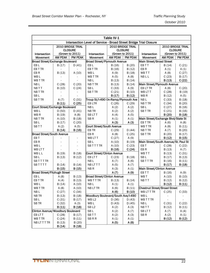
G. TRIAL BRIDGE CLOSURE EVALUATION Intersection Analysis The traffic volumes collected in the peak hour traffic counts were compared and balanced for the volumes taken throughout the study area. Traffic volumes were balanced when intersections were close together without a destination source between them. The Broad Street/South Avenue and Broad Street/Exchange Boulevard intersections were counted multiple times in the trial week to provide a method to compare volume changes between the count days. Traffic volumes figures and count data is included in Appendix F. The results of the Synchro analysis of the studied intersections are summarized in Table IV-1. A summary of findings for each intersection is listed below.
• Woodbury Blvd & South Ave/I-490 Eastbound Ramps – Level of Service (LOS) D was reported for Woodbury traffic movements in both the AM and PM peak hours with LOS A for South Avenue.
• Woodbury Blvd & Clinton Avenue - Satisfactory LOS B and C were reported for traffic movements in both the AM and PM peak hours.

Broad Street Corridor Master Plan – Rochester, NY Traffic Planning Study
October 2010
20
• Troup Street/I490 Ramp & Plymouth Avenue – LOS C was reported for Troup Street traffic movements in both the AM and PM peak hours with LOS A for Plymouth Avenue.
• Broad Street & Chestnut Street - Satisfactory LOS A, B and C were reported for traffic movements in both the AM and PM peak hours.
• Broad Street & Clinton Street - Satisfactory LOS A and B were reported for traffic movements in both the AM and PM peak hours. (This is an intersection of two, one-way streets)
• Broad Street & South Avenue - Satisfactory LOS B was reported for traffic movements in both the AM and PM peak hours.
• Broad Street & Exchange Boulevard - Satisfactory LOS A, B and C were reported for all but one of the traffic movements in both the AM and PM peak hours. An LOS of D was reported for the Broad Street eastbound left turns in both the AM and PM peak hours.
• Broad Street & Fitzhugh Street – Satisfactory LOS A, B and C were reported for traffic movements in both the AM and PM peak hours.
• Broad Street & Plymouth Avenue - Satisfactory LOS A, B and C were reported for traffic movements in both the AM and PM peak hours.
• Court Street & Clinton Avenue - Satisfactory LOS A, B and C were reported for traffic movements in both the AM and PM peak hours.
• Court Street & South Avenue - Satisfactory LOS A, B and C were reported for traffic movements in both the AM and PM peak hours. An LOS of D was reported for the Court Street eastbound through/right movement for the PM peak hour.
• Court Street & Exchange Boulevard - Satisfactory LOS A, B and C were reported for traffic movements in both the AM and PM peak hours. An LOS of D was reported for the Court Street westbound left movement for both the AM and PM peak hours.
• Main Street & Clinton Avenue - Satisfactory LOS A and B were reported for traffic movements in both the AM and PM peak hours.
• Main Street & South Avenue/St. Paul Street - Satisfactory LOS A, B and C were reported for traffic movements in both the AM and PM peak hours.
• Main Street & State Street/Exchange Boulevard - Satisfactory LOS A and B were reported for traffic movements in both the AM and PM peak hours.
• Main Street & Plymouth Avenue - Satisfactory LOS A, B and C were reported for traffic movements in both the AM and PM peak hours.
• Main Street & Broad Street - Satisfactory LOS A, B and C were reported for traffic movements in both the AM and PM peak hours.
Broad Street Corridor Master Plan – Rochester, NY Traffic Planning Study
October 2010
21
Satisfactory Levels of Service were reported for all movements in the Synchro model based on the volumes collected and the traffic signal timings provided by MCDOT. However, the observations indicate that the intersections along the following street segments experienced LOS of F for a 30 to 45 minute period during the PM peak hour:
• Exchange Boulevard from Main Street to south of the Court Street intersection,
• Court Street from Exchange to South Avenue, and • South Avenue between Main Street and Woodbury Boulevard The observation from the video surveillance indicated that some traffic on Court Street waited for two traffic signal cycles before moving through the intersection at South Avenue.
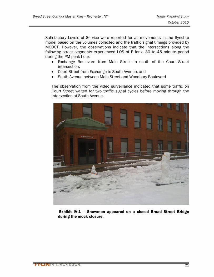
Exhibit IV-1 – Snowmen appeared on a closed Broad Street Bridge during the mock closure.
Broad Street Corridor Master Plan – Rochester, NY Traffic Planning Study
October 2010
22
Table IV-1
Intersection Level of Service - Broad Street Bridge Trial Closure
Intersection Movement
2010 BRIDGE TRIAL CLOSURE
(Grown to 2011) Intersection Movement
2010 BRIDGE TRIAL CLOSURE
(Grown to 2011) Intersection Movement
2010 BRIDGE TRIAL CLOSURE
(Grown to 2011) AM PEAK PM PEAK AM PEAK PM PEAK AM PEAK PM PEAK
Broad Street/Exchange Boulevard Broad Street/Plymouth Avenue Main Street/Broad Street EB L B (17) D (41) EB L B (16) B (20) EB T T B (14) C (21) EB T TR - - EB T TR B (16) B (12) EB R A (1) A (1) EB R B (13) A (10) WB L A (9) B (18) WB T T A (8) C (27) WB L - - WB T TR A (5) A (8) NB L L C (23) B (17) WB T TR - - NB L B (13) B (14) B (13) C (22) NB L C (28) C (20) NB T TR B (13) B (14) Main Street/Plymouth Avenue NB T T B (10) C (24) SB L C (33) A (9) EB LT TR A (8) C (20) NB T TR - - SB T TR C (21) B (10) WB LT T C (28) B (19) SB L - - B (17) B (12) WB R B (12) A (5) SB T TR A (7) C (31) Troup St/I-490 On-Ramp/Plymouth Ave NB L C (33) B (18) B (11) C (25) EB LTR C (26) C (29) NB T TR C (34) B (20) Court Street/Exchange Boulevard NB L A (2) A (2) SB L C (27) B (16) WB L D (50) D (41) NB TR A (2) A (2) SB T TR C (21) B (16) WB R B (19) A (8) SB LT T A (4) A (5) B (20) B (18) NB T TR A (10) B (18) SB R A (1) A (1) Main Street/Exchange Blvd/State St SB L B (17) C (20) A (3) A (3) EB T TR A (6) A (8) SB T T A (2) A (5) Court Street/South Avenue WB T TR A (8) B (11) B (14) B (16) EB TR C (29) D (44) NB T TR A (7) B (20) Broad Street/South Avenue EB R A (8) C (25) SB T TR B (20) B (17) EB T - - WB LT T C (27) A (9) B (12) B (15) EB R - - SB L A (10) B (19) Main Street/South Avenue/St. Paul St WB L - - SB T T T TR A (10) C (23) EB T C (28) C (22) WB LT T - - B (16) C (24) EB R B (13) A (7) WB L L B (19) B (18) Court Street/Clinton Avenue WB T T B (13) C (31) SB L B (13) B (12) EB LT T C (23) B (18) SB L B (17) B (13) SB T T T TR - - NB L A (7) A (6) SB T T TR B (16) B (11) SB T T T T B (14) B (14) NB LT T T A (5) A (7) B (17) B (18) B (15) B (15) NB R A (3) A (1) Main Street/Clinton Avenue Broad Street/Fitzhugh Street A (7) A (9) EB T T B (16) A (9) EB L A (8) B (13) Broad Street/Clinton Avenue WB T A (10) B (10) EB T TR A (4) B (13) WB T T TR B (13) B (14) NB T T B (12) B (12) WB L B (14) A (10) NB L A (1) A (1) B (12) B (11) WB T TR A (8) A (10) NB LT TR A (6) B (11) Chestnut Street/Broad Street NB L C (27) C (34) A (6) B (10) WB LT T TR C (25) C (33) NB TR B (13) B (18) Woodbury Boulevard/South Ave/I-490 WB L - - SB L C (31) B (17) WB L2 D (36) D (43) WB T T TR - - SB TR C (32) A (3) WB L D (43) D (45) NB L C (31) C (22) B (11) B (18) SB L2 A (2) A (3) NB T T B (12) B (11) Clinton Avenue/Woodbury Boulevard SB L A (2) A (7) SB LT T A (7) A (4) EB LT T C (28) B (17) SB T T A (2) A (3) SB R A (2) A (1) WB T TR C (24) B (11) SB R R A (1) A (1) B (12) B (12) NB LT T T TR B (13) B (20) A (5) A (8)
B (14) B (18)

Broad Street Corridor Master Plan – Rochester, NY Traffic Planning Study
October 2010
23
The difference between the analyzed LOS and the observed traffic operations may be due to parking friction or impedance, a higher peak hour factor, and the transit operation impedance at the southwest corner of the Court Street/South Avenue intersection that caused the 30 to 45 minute traffic congestion observed. Satisfactory LOS for the Court Street/South Avenue intersection indicate that the traffic volumes do not exceed capacity, and traffic operation concerns observed in the field can be mitigated with measures discussed later in this report. System Sensor Data Monroe County DOT has various System Sensors detector loops as part of the Central Computerized Traffic Signal System within the study area that record approximate lane volumes. Some of the sensors were either off-line or not collecting data, however, the system sensors that had available data include:
• East Broad Street (east of South Ave) – two sensors, one westbound sensor in each westbound lane (third sensor was blocked off during closure)
• West Broad Street (west of Plymouth Ave) – one eastbound sensor in one of the two eastbound lanes
• Plymouth Ave (south of Broad Street) – one sensor in each lane northbound and southbound (4 sensors total)
• West Main Street (westbound east of State Street and eastbound west of State Street) - one sensor in each direction
• East main Street (westbound east of Clinton Avenue and eastbound west of Clinton Avenue) - one sensor in each direction
• South Washington Street (south of West Broad Street) – one sensor in northbound direction
• Court Street (east of South Avenue) – two sensors eastbound and two sensors westbound
• Northbound Exchange Boulevard (north of Court Street) – one sensor for two lanes
• Southbound Exchange Boulevard (north of Broad Street) – one sensor for two lanes
• Southbound St. Paul Street (north of main Street) – one sensor for three lanes
The average volumes over a 3-week period of time (two weeks prior to the closure of the bridge and one week after the closure) were compared to the average volumes during the second week the bridge was closed. Although the data could not be used to compare actual volumes, the differential between the two scenarios would be evaluated to further assess increases and decreases in traffic on these streets that are part of the study area.

Broad Street Corridor Master Plan – Rochester, NY Traffic Planning Study
October 2010
24
From the graph of the daily traffic data, the approximate peak hour was evaluated to determine the percent difference between the bridge open and bridge closed data. Table IV-2 summarizes the results of this evaluation. The sensor graphs are in Appendix G.

Broad Street Corridor Master Plan – Rochester, NY Traffic Planning Study
October 2010
25
Table IV-2
Sensor Data Comparison: Broad Street Bridge Open vs. Broad Street Bridge Closed
Intersection
Open Peak Hour
Sensor Volume
Closed Peak Hour
Sensor Volume % Diff
Peak Hour
Factor (PHF)
South Washington Northbound AM 1950 1870 -4% 0.97
PM 870 925 6% 0.98
Court Street Eastbound AM 1945 2240 15% 0.92
PM 1920 2040 -6% 0.89
Westbound AM 810 1365 69% 0.92
PM 1900 1970 4% 0.90
Main Street @ State Street Eastbound AM 1225 1260 3% 0.96
PM 1575 1560 -1% 0.93
Westbound AM 1235 1250 1% 0.92
PM 1635 1750 7% 0.91
Exchange Boulevard Northbound AM 1465 1905 30% 0.91
PM 2020 2370 17% 0.93
Southbound AM 2095 1810 -14% 0.91
PM 1835 1590 -13% 0.95
W. Broad Street Eastbound AM 805 635 -21% 0.86
PM 400 395 -1% 0.99
South Plymouth Avenue Northbound AM 745 1375 85% 0.93
PM 765 1380 80% 0.93
Southbound AM 750 705 -6% 0.88
PM 2660 2680 1% 0.84
St. Paul Street Southbound AM 1790 1775 -1% 0.99
PM 1915 1780 -7% 0.88
E. Broad Street Westbound AM 2015 1120 -44% 0.90 PM 2500 1700 -32% 0.90

Broad Street Corridor Master Plan – Rochester, NY Traffic Planning Study
October 2010
26
Although the sensor data only shows trends, some conclusions can be drawn from the data presented. From the sensor data summary table, there are several locations that showed substantial increases. The Court Street AM peak westbound increase of 69% is attributable to the diverted traffic that typically would have used Broad Street to cross the river from east to west. The Court Street AM peak eastbound increase of 15% is attributable to the diverted traffic that typically would have used Broad Street to cross the river from west to east. These percentages are very close to the assumed diversion percentages from the Travel Demand Model. Other substantial increases include northbound Exchange Boulevard in the AM and PM peaks (30% and 17%, respectively) and Plymouth Avenue northbound for both the AM and PM peaks (85% and 80%, respectively). Main Street volumes increased slightly showing that some traffic used Main Street instead of Court Street. Decreases in traffic were found for Broad Street, southbound Exchange Boulevard, and St. Paul Street. Besides the obvious diversion from Broad Street, the southbound Exchange decrease may have been due to people choosing other access to I-490 eastbound via the Inner Loop, Boys Club Place on-ramp or the Plymouth Avenue on-ramp. Similarly for St. Paul Street traffic diversions could use the Inner Loop or Andrews Street to cross the river. Trial Closure Summary and Conclusions During the trial bridge closure, general traffic observations were made and concluded that the overall operations of the study area appeared to flow well during the peak hours. The largest area of concern was along Court Street between South Avenue and Exchange Street. Given that Court Street has only one lane in each direction, there was insufficient capacity to handle the volume during a 30-45 minute timeframe with a 15-20 minute peak of the evening peak hour due to the increased volumes or traffic interruptions by the Dinosaur BBQ restaurant by buses and vehicles at the driveway. This caused congestion not only at the intersections of Court Street & South Avenue and Court Street & Exchange Street, but also delays at Exchange Boulevard & Broad Street, and South Avenue & Broad Street. This congestion was expected, as essentially two westbound and two eastbound lanes across the river were removed.
Main Street did not pick up a substantial amount of additional volume during this trial probably due to turn restrictions at State Street and Clinton Avenue and the designated bus lanes reducing through traffic to one lane in each direction. This also indicates that Main Street will not need to have the bus lanes removed to close the bridge as proposed for Scenario 1 only.
Broad Street Corridor Master Plan – Rochester, NY Traffic Planning Study
October 2010
27
Based on these observations and conclusions, and with the mitigation proposed later in this report, the bridge closure is feasible and can be accomplished with satisfactory levels of service at all intersections and no movements with a Level of Service less than an ‘E’.
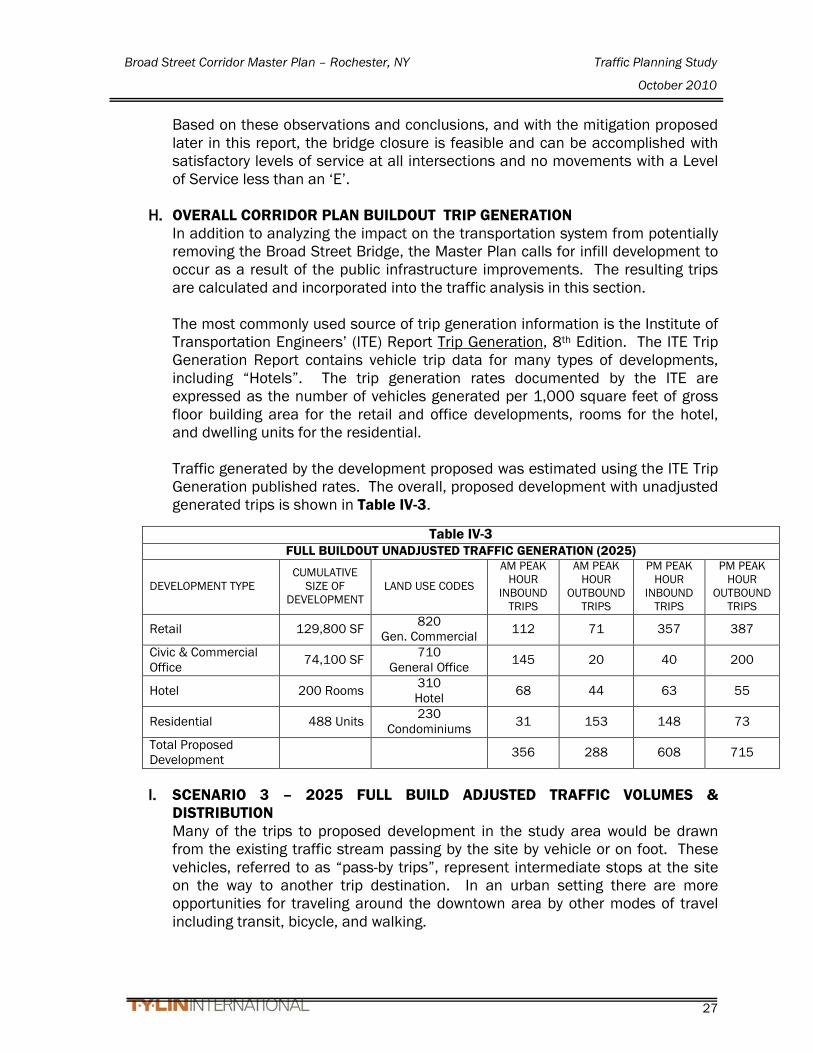
H. OVERALL CORRIDOR PLAN BUILDOUT TRIP GENERATION
In addition to analyzing the impact on the transportation system from potentially removing the Broad Street Bridge, the Master Plan calls for infill development to occur as a result of the public infrastructure improvements. The resulting trips are calculated and incorporated into the traffic analysis in this section. The most commonly used source of trip generation information is the Institute of Transportation Engineers’ (ITE) Report Trip Generation, 8th Edition. The ITE Trip Generation Report contains vehicle trip data for many types of developments, including “Hotels”. The trip generation rates documented by the ITE are expressed as the number of vehicles generated per 1,000 square feet of gross floor building area for the retail and office developments, rooms for the hotel, and dwelling units for the residential. Traffic generated by the development proposed was estimated using the ITE Trip Generation published rates. The overall, proposed development with unadjusted generated trips is shown in Table IV-3.
I. SCENARIO 3 – 2025 FULL BUILD ADJUSTED TRAFFIC VOLUMES &
DISTRIBUTION Many of the trips to proposed development in the study area would be drawn from the existing traffic stream passing by the site by vehicle or on foot. These vehicles, referred to as “pass-by trips”, represent intermediate stops at the site on the way to another trip destination. In an urban setting there are more opportunities for traveling around the downtown area by other modes of travel including transit, bicycle, and walking.
Table IV-3 FULL BUILDOUT UNADJUSTED TRAFFIC GENERATION (2025)
DEVELOPMENT TYPE CUMULATIVE
SIZE OF DEVELOPMENT
LAND USE CODES
AM PEAK HOUR
INBOUND TRIPS
AM PEAK HOUR
OUTBOUND TRIPS
PM PEAK HOUR
INBOUND TRIPS
PM PEAK HOUR
OUTBOUND TRIPS
Retail 129,800 SF 820 Gen. Commercial 112 71 357 387
Civic & Commercial Office 74,100 SF 710
General Office 145 20 40 200
Hotel 200 Rooms 310 Hotel 68 44 63 55
Residential 488 Units 230 Condominiums 31 153 148 73
Total Proposed Development 356 288 608 715
Broad Street Corridor Master Plan – Rochester, NY Traffic Planning Study
October 2010
28
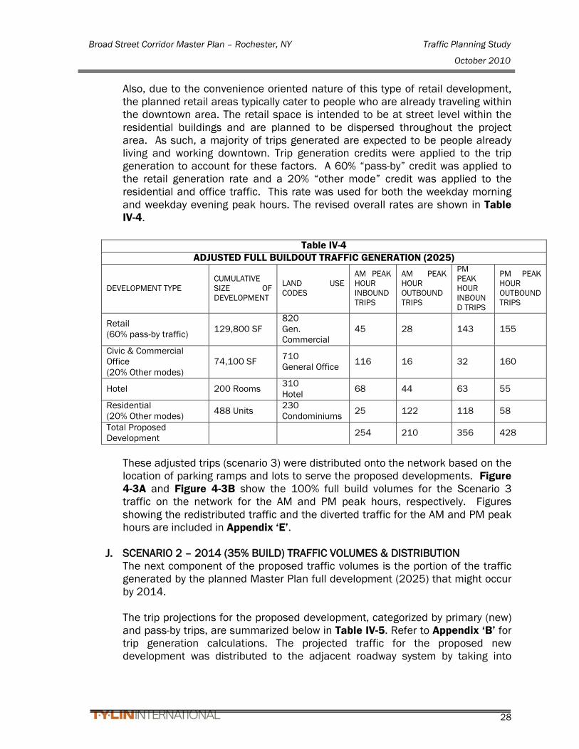
Also, due to the convenience oriented nature of this type of retail development, the planned retail areas typically cater to people who are already traveling within the downtown area. The retail space is intended to be at street level within the residential buildings and are planned to be dispersed throughout the project area. As such, a majority of trips generated are expected to be people already living and working downtown. Trip generation credits were applied to the trip generation to account for these factors. A 60% “pass-by” credit was applied to the retail generation rate and a 20% “other mode” credit was applied to the residential and office traffic. This rate was used for both the weekday morning and weekday evening peak hours. The revised overall rates are shown in Table IV-4.
These adjusted trips (scenario 3) were distributed onto the network based on the location of parking ramps and lots to serve the proposed developments. Figure 4-3A and Figure 4-3B show the 100% full build volumes for the Scenario 3 traffic on the network for the AM and PM peak hours, respectively. Figures showing the redistributed traffic and the diverted traffic for the AM and PM peak hours are included in Appendix ‘E’.
J. SCENARIO 2 – 2014 (35% BUILD) TRAFFIC VOLUMES & DISTRIBUTION The next component of the proposed traffic volumes is the portion of the traffic generated by the planned Master Plan full development (2025) that might occur by 2014. The trip projections for the proposed development, categorized by primary (new) and pass-by trips, are summarized below in Table IV-5. Refer to Appendix ‘B’ for trip generation calculations. The projected traffic for the proposed new development was distributed to the adjacent roadway system by taking into
Table IV-4 ADJUSTED FULL BUILDOUT TRAFFIC GENERATION (2025)
DEVELOPMENT TYPE CUMULATIVE SIZE OF DEVELOPMENT
LAND USE CODES
AM PEAK HOUR INBOUND TRIPS
AM PEAK HOUR OUTBOUND TRIPS
PM PEAK HOUR INBOUND TRIPS
PM PEAK HOUR OUTBOUND TRIPS
Retail (60% pass-by traffic) 129,800 SF
820 Gen. Commercial
45 28 143 155
Civic & Commercial Office (20% Other modes)
74,100 SF 710 General Office 116 16 32 160
Hotel 200 Rooms 310 Hotel 68 44 63 55
Residential (20% Other modes) 488 Units 230
Condominiums 25 122 118 58
Total Proposed Development 254 210 356 428

Broad Street Corridor Master Plan – Rochester, NY Traffic Planning Study
October 2010
29
consideration the surrounding parking areas, existing traffic patterns, and logical routing patterns. These adjusted trips (scenario 2) were distributed onto the network. Scenario 2 assumes that development occurs mostly within the area of the Phase 1 and 2 improvements. Table IV-5 shows the composition and traffic distribution.
Table IV-5
SCENARIO 2 - 2014 TRAFFIC GENERATION (35% OF FULL DEVELOPMENT 2025)
DEVELOPMENT TYPE
CUMULATIVE SIZE OF
DEVELOPMENT LAND USE CODES
AM PEAK HOUR
INBOUND TRIPS
AM PEAK HOUR
OUTBOUND TRIPS
PM PEAK HOUR
INBOUND TRIPS
PM PEAK HOUR
OUTBOUND TRIPS
Scenario 2 – East of Fitzhugh Street
Retail 63,900 SF 820 Gen.
Commercial 22 14 70 76
Residential 416 Units 230 Condominiums 21 104 101 49
Total Scenario 2 Trips 43 118 171 125
Figure 3-6A and Figure 3-6B show the 35% build volume for the Scenario 2 traffic on the network for the AM and PM peak hours, respectively. Figures showing the redistributed traffic and the diverted traffic for the AM and PM peak hours are included in Appendix ‘E’.
Broad Street Corridor Master Plan – Rochester, NY Traffic Planning Study
October 2010
30
V. TRAFFIC OPERATIONS
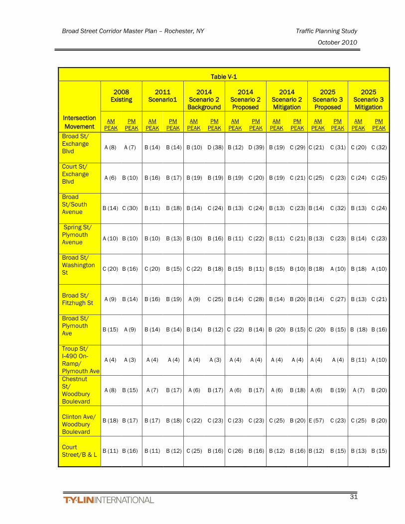
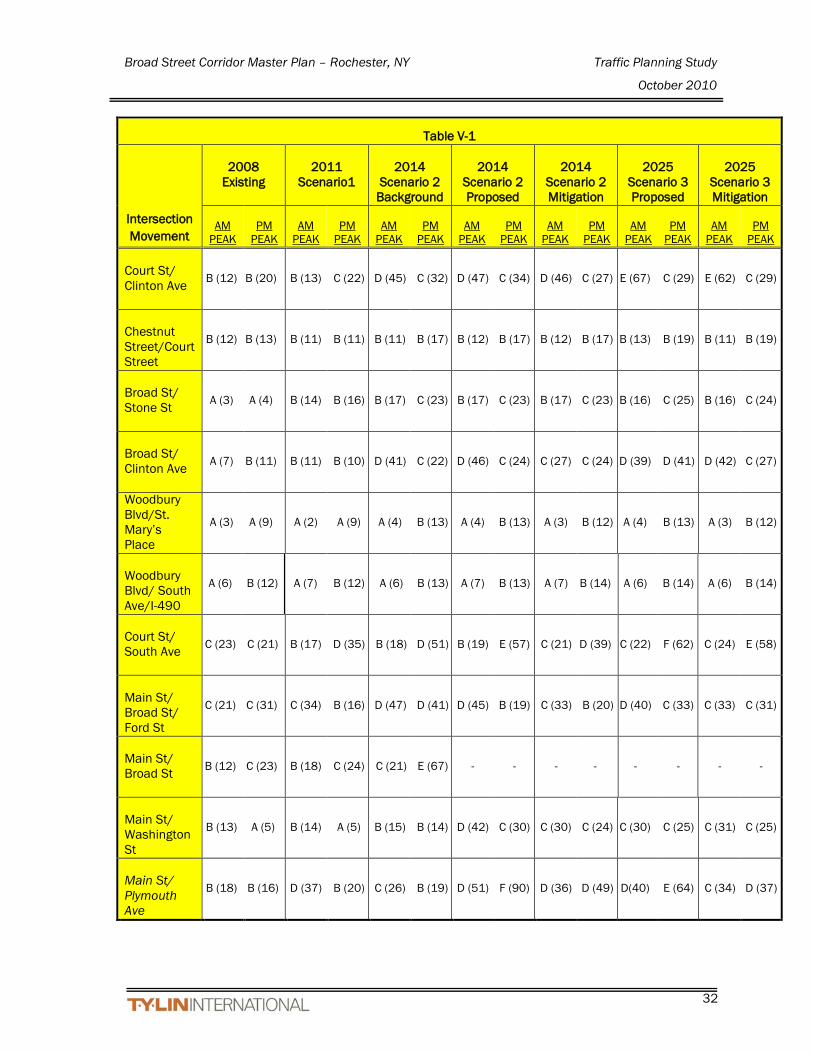
A. EXISTING AND PROPOSED TRAFFIC OPERATIONS The Level of Service (LOS) analysis methodology for analyzing signalized intersections is documented in the Highway Capacity Manual (Transportation Research Board, Washington, D.C., 2000). The traffic-software Synchro 7 build 761, was used to analyze the studied intersections using the network model provided by Monroe County Department of Transportation (MCDOT). Levels of Service for signalized intersections are expressed in terms of average control delay per vehicle. Full definitions of LOS for signalized intersections are included in Appendix C. Located in Appendix C, Table V-1 presents a summary of the weekday morning and evening peak hours for the intersection capacity analysis results for the Existing 2008, the proposed 2011 Scenario, the proposed 2014 Background traffic scenario and the 2014 Proposed (35% Build) Scenario, the full-build 2025 scenario 3 and then the 2025 Scenario 3 with mitigation of the intersections with low level of service. The Synchro Level of Service analyses are provided in Appendix D.
Broad Street Corridor Master Plan – Rochester, NY Traffic Planning Study
October 2010
31
Table V-1
Intersection Movement
2008
Existing
2011
Scenario1
2014 Scenario 2
Background
2014 Scenario 2 Proposed
2014 Scenario 2 Mitigation
2025 Scenario 3 Proposed
2025 Scenario 3 Mitigation
AM
PEAK PM
PEAK AM
PEAK PM
PEAK AM
PEAK PM
PEAK AM
PEAK PM
PEAK AM
PEAK PM
PEAK AM
PEAK PM
PEAK AM
PEAK PM
PEAK Broad St/ Exchange Blvd
A (8) A (7) B (14) B (14) B (10) D (38) B (12) D (39) B (19) C (29) C (21) C (31) C (20) C (32)
Court St/ Exchange Blvd
A (6) B (10) B (16) B (17) B (19) B (19) B (19) C (20) B (19) C (21) C (25) C (23) C (24) C (25)
Broad St/South Avenue
B (14) C (30) B (11) B (18) B (14) C (24) B (13) C (24) B (13) C (23) B (14) C (32) B (13) C (24)
Spring St/ Plymouth Avenue
A (10) B (10) B (10) B (13) B (10) B (16) B (11) C (22) B (11) C (21) B (13) C (23) B (14) C (23)
Broad St/ Washington St
C (20) B (16) C (20) B (15) C (22) B (18) B (15) B (11) B (15) B (10) B (18) A (10) B (18) A (10)
Broad St/ Fitzhugh St
A (9) B (14) B (16) B (19) A (9) C (25) B (14) C (28) B (14) B (20) B (14) C (27) B (13) C (21)
Broad St/ Plymouth Ave
B (15) A (9) B (14) B (14) B (14) B (12) C (22) B (14) B (20) B (15) C (20) B (15) B (18) B (16)
Troup St/ I-490 On-Ramp/ Plymouth Ave
A (4) A (3) A (4) A (4) A (4) A (3) A (4) A (4) A (4) A (4) A (4) A (4) B (11) A (10)
Chestnut St/ Woodbury Boulevard
A (8) B (15) A (7) B (17) A (6) B (17) A (6) B (17) A (6) B (18) A (6) B (19) A (7) B (20)
Clinton Ave/ Woodbury Boulevard
B (18) B (17) B (17) B (18) C (22) C (23) C (23) C (23) C (25) B (20) E (57) C (23) C (25) B (20)
Court Street/B & L
B (11) B (16) B (11) B (12) C (25) B (16) C (26) B (16) B (12) B (16) B (12) B (15) B (13) B (15)
Broad Street Corridor Master Plan – Rochester, NY Traffic Planning Study
October 2010
32
Table V-1
Intersection Movement
2008
Existing
2011
Scenario1
2014 Scenario 2
Background
2014 Scenario 2 Proposed
2014 Scenario 2 Mitigation
2025 Scenario 3 Proposed
2025 Scenario 3 Mitigation
AM
PEAK PM
PEAK AM
PEAK PM
PEAK AM
PEAK PM
PEAK AM
PEAK PM
PEAK AM
PEAK PM
PEAK AM
PEAK PM
PEAK AM
PEAK PM
PEAK Court St/ Clinton Ave
B (12) B (20) B (13) C (22) D (45) C (32) D (47) C (34) D (46) C (27) E (67) C (29) E (62) C (29)
Chestnut Street/Court Street
B (12) B (13) B (11) B (11) B (11) B (17) B (12) B (17) B (12) B (17) B (13) B (19) B (11) B (19)
Broad St/ Stone St
A (3) A (4) B (14) B (16) B (17) C (23) B (17) C (23) B (17) C (23) B (16) C (25) B (16) C (24)
Broad St/ Clinton Ave
A (7) B (11) B (11) B (10) D (41) C (22) D (46) C (24) C (27) C (24) D (39) D (41) D (42) C (27)
Woodbury Blvd/St. Mary’s Place
A (3) A (9) A (2) A (9) A (4) B (13) A (4) B (13) A (3) B (12) A (4) B (13) A (3) B (12)
Woodbury Blvd/ South Ave/I-490
A (6) B (12) A (7) B (12) A (6) B (13) A (7) B (13) A (7) B (14) A (6) B (14) A (6) B (14)
Court St/ South Ave
C (23) C (21) B (17) D (35) B (18) D (51) B (19) E (57) C (21) D (39) C (22) F (62) C (24) E (58)
Main St/ Broad St/ Ford St
C (21) C (31) C (34) B (16) D (47) D (41) D (45) B (19) C (33) B (20) D (40) C (33) C (33) C (31)
Main St/ Broad St
B (12) C (23) B (18) C (24) C (21) E (67) - - - - - - - -
Main St/ Washington St
B (13) A (5) B (14) A (5) B (15) B (14) D (42) C (30) C (30) C (24) C (30) C (25) C (31) C (25)
Main St/ Plymouth Ave
B (18) B (16) D (37) B (20) C (26) B (19) D (51) F (90) D (36) D (49) D(40) E (64) C (34) D (37)

Broad Street Corridor Master Plan – Rochester, NY Traffic Planning Study
October 2010
33
Table V-1
Intersection Movement
2008
Existing
2011
Scenario1
2014 Scenario 2
Background
2014 Scenario 2 Proposed
2014 Scenario 2 Mitigation
2025 Scenario 3 Proposed
2025 Scenario 3 Mitigation
AM
PEAK PM
PEAK AM
PEAK PM
PEAK AM
PEAK PM
PEAK AM
PEAK PM
PEAK AM
PEAK PM
PEAK AM
PEAK PM
PEAK AM
PEAK PM
PEAK Main St/ Fitzhugh St
B (14) B (16) C (22) B (19) B (12) C (21) B (12) C (31) B (18) B (18) B (19) B (20) B (18) B (18)
Main St/ Exchange Blvd/ State St
B (14) B (17) B (19) C (20) C (25) D (40) C (26) D (41) B (18) C (34) C (25) D (39) B (14) D (40)
Main St/ South Ave/ St. Paul St
B (20) C (20) B (20) B (20) B (20) B (17) B (20) C (20) C (20) C (22) C (22) C (27) C (22) C (26)
Main St/ Clinton Ave
B (13) B (17) B (16) B (19) C (21) C (26) C (22) C (26) C (22) C (26) C (23) C (30) C (23) C (30)
Chestnut St/Broad St
B (12) B (15) B (15) B (14) B (16) B (14) B (17) B (15) B (17) B (15) B (17) B (16) B (17) B (16)
As shown in Table V-1, all the studied intersections are anticipated to operate with an overall acceptable LOS ‘D’ or better for future 2011 Scenario 1 conditions during the AM and PM peak hours. With the exception of the following intersections all the studied intersections are anticipated to operate with an overall acceptable LOS ‘D’ or better for future 2014 Scenario 2 (build) conditions during the AM and PM peak hours:
• Main Street/Broad Street • Main Street/Plymouth Avenue
With the intersection improvements recommended for Scenario 2 all intersections are anticipated to operate at LOS ‘D’ or better. With the exception of the following intersections all the studied intersections are anticipated to operate with an overall acceptable LOS ‘D’ or better for future 2025 Scenario 3 (build) conditions during the AM and PM peak hours:
• Clinton Avenue/Woodbury Boulevard • Court Street/Clinton Avenue • Court Street/South Avenue
Broad Street Corridor Master Plan – Rochester, NY Traffic Planning Study
October 2010
34
• Main Street/Plymouth Avenue Intersection improvements are recommended for Scenario 3 to remediate failing levels of service and reduce delay triggered by the additional development.
The following is a detailed summary of the Level of Service analysis results for intersections with a projected overall LOS ‘E’ or lower for the future build scenarios: Woodbury Boulevard @ Clinton Avenue The signalized intersection of Woodbury Boulevard and Clinton Avenue currently operates at an overall LOS ‘B’ for the AM and PM peak hours studied. The intersection’s LOS is expected to remain consistent for Scenario 1 (2011) and degrade slightly for the Scenario 2 (2014) background analysis to an overall LOS ‘C’ during the AM and PM peak hours. For the proposed Scenario 2 (2014) build condition the intersection is expected to remain at an overall LOS ‘C’ for both AM and PM peak hours. However, with construction of the proposed Scenario 3 (2025) build condition, the overall intersection LOS is expected to degrade to a LOS ‘E’ for the AM peak hour. With the mitigation measures in-place the intersection is expected to operate at an overall LOS ‘C’ or better for the AM and PM peak hours. Court Street @ Clinton Avenue The existing signalized intersection of Court Street and Clinton Avenue operates at an overall LOS ‘B’ for the AM and PM peak hours studied. The intersection’s LOS is expected to remain consistent for Scenario 1 (2011) and degrade slightly for the Scenario 2 (2014) background analysis to an overall LOS ‘D’ during the AM peak hour and to an overall LOS ‘C’ during the PM peak hour. For the proposed Scenario 2 (2014) build condition the intersection is expected to remain relatively unchanged for both AM and PM peak hours. However, with construction of the proposed Scenario 3 (2025) build condition, the overall intersection LOS is expected to degrade to a LOS ‘E’ for the AM peak hour. Mitigation measures are recommended to balance the intersection’s individual approaches, however the overall intersection is expected to continue to operate at a LOS ‘E’ for the AM peak hour. The PM peak hour is expected to operate at an overall LOS ‘C’ as commuter traffic patterns in this location differ during the PM peak hour from the Am peak hour. Court Street @ South Avenue The signalized intersection of Court Street and South Ave currently operates at an overall LOS ‘C’ for both the AM and PM peak hours studied. With the construction of Scenario 1 (2011), the intersection’s LOS is expected increase during the AM peak hour and to degrade slightly to a LOS ‘D’ for the PM peak hour. The intersection is expected to remain consistent for the Scenario 2 (2014) background analysis.

Broad Street Corridor Master Plan – Rochester, NY Traffic Planning Study
October 2010
35
For the proposed Scenario 2 (2014) build condition the intersection is expected to degrade slightly to an overall LOS ‘C and an overall LOS ‘E’ for the AM and PM peak hours, respectively. However, with the recommended mitigation measures in place for Scenario 2, the intersection is expected to operate at an overall LOS ‘D’ or better for both the AM and PM peak hours. With construction of the proposed Scenario 3 (2025) build condition, an overall LOS ‘C; is expected for the AM peak hour and the intersection is expected to fail during the PM peak hour. However, with the recommended mitigation measures in-place, the intersection is expected to operate at an overall LOS ‘D’ or better for the AM and PM peak hours. Main Street @ Plymouth Avenue The signalized intersection of Main Street and Plymouth Avenue currently operates at an overall LOS ‘B’ for the AM and PM peak hours studied. The intersection’s LOS is expected to degrade slightly for Scenario 1 (2011) and the Scenario 2 (2014) background analysis during the AM peak hour and is expected to remain consistent during the PM peak hour. For the proposed Scenario 2 (2014) build condition the intersection is expected fail during the PM peak hour. However, with the recommended mitigation measures in place, the intersection is expected to operate at an overall LOS ‘D’ for both the AM and PM peak hours. With the construction of the proposed Scenario 3 (2025) build condition, the overall intersection LOS is expected remain at a LOS ‘D’ for the AM peak hour and degrade to a LOS ‘E’ for the PM peak hour. However, with the proposed mitigation measures, the intersection is expected to operate at an overall LOS ‘D’ or better for the AM and PM peak hours.
VI. PUBLIC TRANSPORTATION
Downtown Rochester is the hub for the Regional Transit Service (RTS) bus system, operated by the Rochester Genesee Regional Transportation Authority (RGRTA). Within the study area, a total of 34 bus routes pass through the study area. Table VI-1 summarizes the frequency of bus service by bus routes for each service operating within the project study area. The routings of the RTS buses within the study area is also depicted in Figure 5. As can be seen in Table VI-1, there are 34 bus routes, the majority of these routes providing 15 to 30 minute headways into the downtown area. Of the three river crossings, Main Street receives the highest volumes of bus traffic (in both directions), while Broad Street receives only westbound traffic and Court Street receives only eastbound traffic.

Broad Street Corridor Master Plan – Rochester, NY Traffic Planning Study
October 2010
36
At the Broad Street bridge, many of the 16 buses during the morning peak period (7-9 AM) and 34 buses during the evening peak period (4-6 PM) actually make a loop from westbound Broad Street, turning left onto Exchange Boulevard, stopping at the Hall of Justice/Blue Cross Arena stop, making a second left onto Court Street, followed by a right turn onto South Avenue (primarily heading to eastbound I-490). The bus routes that operate in this fashion include Routes 21, 22, 30,35,40,91 and 92. As mentioned above, Main Street is the primary transit corridor, and in the study area vicinity, the area of heaviest transit activity occurs at the intersection of Main Street with St. Paul Street/South Avenue. RTS has two transit hubs where bus routes typically begin/end: 1) Main Street at the Liberty Pole, and 2) Broad Street Station. There are plans by the RGRTA to replace these two transit hubs with one larger facility as part of the propose Transit Center development located along Mortimer Street, which is north of Main Street between St. Paul Street and North Clinton Avenue. Main Street currently has bus lanes in both directions. These lanes are reserved for buses and right-turning vehicles. Since the Transit Center project will create a new transit station, the exclusive bus lanes on Main Street will be eliminated for the 2014 and 2025 analyses. Broad Street Station is located at the corner of Broad Street with Chestnut Street and James Street. Several bus routes (30, 91 and 92) now use Broad Street westbound between this station and the Civic Center/Hall of Justice crossing the Broad Street Aqueduct Bridge before returning back via the Court Street Bridge and South Avenue back onto I-490. Bus Routes 21 and 22 only cross the River as an alternate route to South Avenue.

Broad Street Corridor Master Plan – Rochester, NY Traffic Planning Study
October 2010
37
Table VI-1
Existing Public Transit Services
Buses During Peak Period Route Crossing over Genesee River
Route AM PM Broad Street Main Street Court Street No. Route Name In Out In Out EB WB EB WB EB WB
1/1x Lake 7 / 8 8 / 7 x x 2/2x Thurston 6 / 5 5 / 5 x x 2/2x Parsells 6 / 6 5 / 5 3abc Lyell 9 / 8 7 / 8 x x 3/3x Goodman 6 / 6 5 / 6 4/4x Hudson 7 / 6 7 / 7 4/4x Genesee 6 / 7 7 / 6 x x 5/5x St. Paul 5 / 6 6 / 5 5/5x South 5 / 6 5 / 5 6/6x Clifford 5 / 5 4 / 5 6/6x Jefferson 5 / 5 5 / 5 x x 7/7x Clinton 7 / 7 6 / 6 7/7x Monroe 7 / 8 7 / 6
8 Chili/Strong 7 / 7 7 / 8 x x 9 Jay/Maple 4 / 4 5 / 4 x x
10/10x Portland 7 / 8 9 / 9 10/10x Dewey 9 / 9 9 / 9 x x 11/11x S. Clinton 6 / 6 6 / 6 11/11x Joseph 6 / 5 6 / 6
14 Ridge Road 4 / 1 2 / 3 x x x 15 Dewey/Latta 5 / 2 1 / 7 x x 16 Crosstown 4 / 3 4 / 3 x x 17 East Ave to Pittsford 2 / 2 2 / 2
18/19 University 5 / 2 4 / 4 x 18/19 Plymouth 4 / 4 5 / 4 x x
20 Brockport/Spencerport 3 / 1 2 / 4 x x 21 E. Rochester/Fairport 9 / 4 3 / 8 x x 22 Penfield 3 / 3 4 / 4 x x
24 RIT/Marketplace Mall/Scottsville 2 / 2 3 / 3
30/40/45 Webster/ Xerox via Empire Creek 4 / 1 2 / 3
x x
50 MCC/ Mt. Hope 2 / 5 2 / 1
91 Avon/Suburban Plaza 5 / 4 2 / 5
x x
92 Perinton/Bushnell's Basin/Lyons/Eastview Mall 5 / 2 2 / 5
x x
96 Hilton/Hamlin/Clarkson 3 / 0 0 / 2 x AM Peak Period (7-9AM) - Total Buses 0 16 75 63 14 0 PM Peak Period (4-6PM) - Total Buses 0 34 67 73 25 0
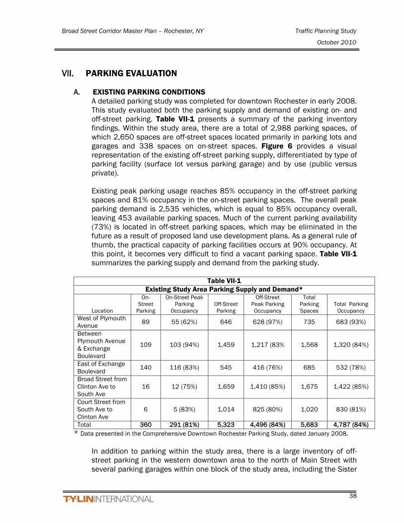
Broad Street Corridor Master Plan – Rochester, NY Traffic Planning Study
October 2010
38
VII. PARKING EVALUATION
A. EXISTING PARKING CONDITIONS A detailed parking study was completed for downtown Rochester in early 2008. This study evaluated both the parking supply and demand of existing on- and off-street parking. Table VII-1 presents a summary of the parking inventory findings. Within the study area, there are a total of 2,988 parking spaces, of which 2,650 spaces are off-street spaces located primarily in parking lots and garages and 338 spaces on on-street spaces. Figure 6 provides a visual representation of the existing off-street parking supply, differentiated by type of parking facility (surface lot versus parking garage) and by use (public versus private). Existing peak parking usage reaches 85% occupancy in the off-street parking spaces and 81% occupancy in the on-street parking spaces. The overall peak parking demand is 2,535 vehicles, which is equal to 85% occupancy overall, leaving 453 available parking spaces. Much of the current parking availability (73%) is located in off-street parking spaces, which may be eliminated in the future as a result of proposed land use development plans. As a general rule of thumb, the practical capacity of parking facilities occurs at 90% occupancy. At this point, it becomes very difficult to find a vacant parking space. Table VII-1 summarizes the parking supply and demand from the parking study.
Table VII-1
Existing Study Area Parking Supply and Demand*
Location
On-Street
Parking
On-Street Peak Parking
Occupancy Off-Street Parking
Off-Street Peak Parking Occupancy
Total Parking Spaces
Total Parking Occupancy
West of Plymouth Avenue 89 55 (62%) 646 628 (97%) 735 683 (93%)
Between Plymouth Avenue & Exchange Boulevard
109 103 (94%) 1,459 1,217 (83% 1,568 1,320 (84%)
East of Exchange Boulevard 140 116 (83%) 545 416 (76%) 685 532 (78%)
Broad Street from Clinton Ave to South Ave
16 12 (75%) 1,659 1,410 (85%) 1,675 1,422 (85%)
Court Street from South Ave to Clinton Ave
6 5 (83%) 1,014 825 (80%) 1,020 830 (81%)
Total 360 291 (81%) 5,323 4,496 (84%) 5,683 4,787 (84%) * Data presented in the Comprehensive Downtown Rochester Parking Study, dated January 2008.
In addition to parking within the study area, there is a large inventory of off-street parking in the western downtown area to the north of Main Street with several parking garages within one block of the study area, including the Sister

Broad Street Corridor Master Plan – Rochester, NY Traffic Planning Study
October 2010
39
Cities parking garage on Fitzhugh Street (991 spaces), the Genesee Crossroads parking garage on State Street (604 spaces), and the Clarion Riverside Hotel Garage on St. Paul Street (181 spaces). On-street parking spaces and surface lots within the study area, that are located north and south of Broad Street between Main Street (near Cascade Street) and Clinton Avenue, have a total of 1,300 and 338 existing spaces, respectively.
B. MASTER PLAN STREET IMPROVEMENT EFFECTS ON PARKING The proposed master plan projects replacing the surface lots with ramp garages providing 1,735 spaces; 1,410 for future development and 325 additional spaces for public use. This yields a net increase of 435 spaces for the surface lot replacements as off-street parking. The closure of the two Broad Street sections; between Exchange Boulevard and South Avenue and between Main Street and Washington Street; will result in a loss of 107 on street parking spaces, which means that 68% of the on-street parking in the study area will be retained (231 out of the 338 existing spaces). For the overall study area, the street improvements and planned development would provide a net increase of 328 parking spaces.

Broad Street Corridor Master Plan – Rochester, NY Traffic Planning Study
October 2010
40
VIII. CONCLUSIONS AND RECOMMENDATIONS The proposed Broad Street Corridor Master Plan recommended alternative includes closing the Broad Street Bridge to rewater the aqueduct, converting Broad Street to a boulevard with one lane in each direction and adjacent parking, and closing the section of Broad Street between South Washington Street and West Main Street to rewater this area. Overall levels of service for the signalized intersections within the study area will be ‘E’ or better, and parking impacts from the loss on-street parking is largely mitigated.
A. SCENARIO 1 MITIGATION (2011, Bridge Closure) To mitigate the intersections that would have a Level of Service of E or F under
the proposed 2011 Bridge Closure scenario, the following physical improvements are proposed:
Restripe the Court Street section between Exchange Boulevard and South
Avenue to provide; one lane westbound with two westbound lanes on the west end of the section and two eastbound lanes with parking on the south side transitioning to three eastbound lanes on the east end of the section.
At the intersection of Court Street with South Avenue, modify the westbound approach lane geometry from a left/through and through to an exclusive left and one through lane.
On Exchange Boulevard between Broad Street and Court Street, restripe the inside southbound lane as a left only and then the curb lane would be the through lane. The northbound left turn lane would be extended towards Court Street providing side-by-side turn lanes to increase storage capacity for these two left turn movements. Extension of the turning lanes would involve removal of the existing pedestrian island in Exchange Boulevard midblock between Broad Street and Court Street. However, the existing pedestrian island on the south leg of Exchange Boulevard and Court Street would remain.
Exhibit VIII-1 –Exchange Boulevard with Mitigation (Court Street to Broad Street)

Broad Street Corridor Master Plan – Rochester, NY Traffic Planning Study
October 2010
41
B. SCENARIO 2 MITIGATION (2014, 35% Development)
To mitigate the intersections that would have a Level of Service of E or F under the proposed 2014 35% build scenario, the following additional physical improvements are proposed:
On Main Street at Washington Street and Plymouth Ave, widen and restripe Main Street between the I-490 overpass and Fitzhugh Street to provide opposing left turns on Main Street (a five lane section) and remove parking from the south side of the street. In addition, at the intersection of Main Street with Plymouth Avenue, modify the traffic signal operation to provide a protected/permitted left turn phase for each approach.
On Main Street from Exchange Boulevard/State Street to East Avenue, maintain the current four lane section with the removal of the exclusive bus lanes. This is necessary for the 35% development phase (2014) when the section of Broad Street is proposed to be closed west of Washington Street.
On Exchange Boulevard at Broad Street, modify the traffic signal operation to provide a protected/permitted northbound left turn phase.
Optimization of traffic signals timings are recommended where necessary.
C. SCENARIO 3 MITIGATION (2025, Full Development) To mitigate the intersections that would have a Level of Service of E or F under the proposed 2025 full-build scenario, the following physical improvements are proposed in addition to the improvements proposed for 2014:
At the intersection of Main Street with Plymouth Avenue, add a right-turn at the westbound approach.
Reverse the direction of Troup Street between South Fitzhugh Street and South Plymouth from one-way EB to one-way WB. Construct an additional connection for westbound traffic on Troup street between Exchange boulevard and Plymouth Avenue, which is currently one-way eastbound in this section. This connection will provide alternative access for the Court/Exchange area to the I-490 eastbound from the Plymouth Avenue on-ramp, without crossing the river via Court Street. Modify the Plymouth/Troup signal to add WB heads and loops.
Optimization of traffic signals timings will be needed to adjust for revised geometries and traffic patterns.
D. EFFECTS ON ON-STREET PARKING DUE TO MITIGATION IMPROVEMENTS
The restriping of Main Street to five lanes between Broad Street and Fitzhugh Street will result in the loss of 24 spaces on the south side of Main Street.

Broad Street Corridor Master Plan – Rochester, NY Traffic Planning Study
October 2010
42
The reconfiguration of Court Street between Fitzhugh Street and South Avenue will result in a net gain of 1 space. There are 22 spaces existing on the north side of the street and 14 spaces on the south side Court Street with almost all of these spaces on the bridge only. Removing parking on the north side will result in the loss of the 22 spaces, but providing parking spaces on Broad Street between the bridge and Fitzhugh Street would gain 14 spaces that are currently not provided.
Exhibit VIII-2 –Court Street with Mitigation @ South Avenue
The changes in on-street parking within the study area for this project are a net loss of 123 spaces, a loss of 107 within the Broad Street corridor, a loss of 24 in the Main Street corridor and a net gain of 8 spaces in the Court Street corridor. However, the net increase of 435 planned off-street parking will provide an overall net gain of 328 spaces in parking supply within the study area. A majority of the proposed parking spaces are planned in new parking garages and surface lots west of Exchange Street. The creation of new parking spaces is planned to coincide with the future development phases as outlined in the Broad Street Corridor Master Plan Study dated May 2009.

Broad Street Corridor Master Plan – Rochester, NY Traffic Planning Study
October 2010
43
REFERENCES
1. Federal Highway Administration, Highway Capacity Manual, Special Report
209, Washington, D.C., 2000.
2. Institute of Transportation Engineers, Trip Generation, 8th Edition,
Washington, D.C., 2003.
3. Institute of Transportation Engineers, Trip Generation Handbook, 8th Edition,
Washington, D.C., 2003.
4. Monroe County Department of Transportation Traffic Volume Database,
(Excel Spreadsheet) Rochester, New York, 2008.
5. Trafficware, SYNCHRO PLUS SIMTRAFFIC, Version 7, Build 761, Albany,
California, 2006.