traffic terminal and park & ride development “. railway and...
TRANSCRIPT

JAKARTA INTEGRATED URBAN TRANSPORT HUB DEVELOPMENT Final Report
2 - 25
2.2.2 Position with Respect to Upper Level Plan
Position of the Dukuh Atas area stated in the upper level plan is shown in Figure-2.2.20
1) Stated Position in the MPA Master Plan Study in JABODETABEK Area As cooperation agreement for the “Establishing Metropolitan Priority Areas” was signed between
Japanese and the Indonesian government in December, 2010, JICA has started its “Master Plan Study
for Establishing Metropolitan Priority Area for Investment and Industry (MPA) in JABODETABEK
Area” from May, 2011 to set forward the MPA framework.
From the Master Plan Study, The 3rd Steering Committee was held on October, 2012, where the
Dukuh Atas area was chosen as a first priority development area in the “Fast Track Projects: ” As
part of the “A. Better Urban Environment, A1. New public transport System based on the MRT, (4)
Traffic Terminal and Park & Ride development “.
Inside the master plan study, the project goal is to improve accessibility of the citizens to the
amenities located in the stations by solving congestions and to introduce multi-modal facility at the
railway and MRT stations.
Also for the MRT north-south line constructions is stated in the upper master plan of the national
level, MP3EI (Master Plan for the Acceleration and Expansion of Indonesia's Economic Development
2011-2025) , Dukuh Atas area individually is not stated in the national level.
2) Position with respect to RTRW(Spatial Plan DKI Jakarta) 2011-2030 The Jakarta Provincial Government has adopted the Spatial Plan DKI Jakarta (RTRW) 2011-2030 as
the spatial plan for the governments in all parts of the province as the highest level plan. For each
subdistrict, building to land ratios, floor area ratios, road widths, etc., are defined in the City Plan Sheet
(LRK). As a rule the LRK (City Plan Sheet) is revised every five years as needed. Also, for areas where
new large scale land use changes are anticipated, prior to the preparation of the LRK, in the Urban
Design Guidelines (UDGL) new land use policies, building area ratios, floor area ratios are set, and
after approval by the Regional Spatial Coordination Team of Jakarta (Tim Koordinasi Penataan Ruang
Daerah Khusus Ibukota Jakarta ) the LRK (City Plan Sheet) is prepared.

JAKARTA INTEGRATED Final Report URBAN TRANSPORT HUB DEVELOPMENT
2 - 26
1.1.1.1.RTRW SPATIAL PLAN DKI JAKARTA 2011----2030 (RTRW(RENCANA TATA RUANG WILAYAH)DKI JAKARTA 2011-2030) This is a spatial plan for all cities and regions in Jakarta (East, West, South, North, Central, Thousand Islands) for 20 years. It defines road, railway, and new traffic plans, land development directions (uses in 11 major categories), measures against disasters, etc.
4.4.4.4.LRKLRKLRKLRK City Plan Sheet
1:1000 use restriction maps (41 types of use, individual / group) building area ratios, floor area ratios, height restrictions, set backs, road widths
A. KRKKRKKRKKRK Dependency City Plan (disclosed only to those with development authority)
(KRK (Keterangan Lembar Rencana Kota)
B.RTLBRTLBRTLBRTLB (submitted by developers) (RTLB (Rencana Tata Letak Bangunan) 1:1000 Spatial layout plans for
individual/group buildings for specific areas
2.2.2.2.UDGL Urban Design Guide Line (UDGL(Panduan Rancang Kota)) Prior to preparation of 1:1000 LRK use restriction maps, use restriction map proposals and area policy proposals are prepared for new development areas
3.3.3.3.Urban Development Guide Line
(Pedoman Pembangunan Kota)
Draft plan for urban facilities, etc., necessary for new development Roads, car parks, infrastructure, etc.
Regional Spatial Coordination Team of Jakarta (Tim Koordinasi Penataan Ruang Daerah Khusus Ibukota Jakarta ) Development study team established by Governor of Jakarta
New developments with major development impact (associated with change of use)
Prepare
Prepare
Study
Approval by Governor of Jakarta Province Reflected in changes in LRK
Compliance with LRK
Detailed disclosure to those with development authority
Final development permit
Submit development building plan
Incentives Deregulation
Normal development
Master Plan of Acceleration and Expansion of Indonesia
Economic Development (MP3EI)
Master Plan for Establishing Metropolitan Priority Area (MPA) for Investment and
Industry
Regional Spatial Plan Jabodetabek- punjur (Presidential Decree No.54/2008)
National Spatial Plan (RTRWN)
SPATIAL PLANNING SYSTEM
National Long-Term Development Plan (RPJPN 2005-2025)
National Medium-Term Development Plan (RPJMN 2010-2014)
Government Work Plan and
Draft Budget Revenue
FINANCIAL & PLANNING SYSTEM
MRT North-South Line
Dukuh Atas Area (Fast Track, Priority Project: Urban Transport
Figure-2.2.20 Land use map DKI Jakarta Province 2008 Source: Study Team

JAKARTA INTEGRATED URBAN TRANSPORT HUB DEVELOPMENT Final Report
2 - 27
Figure-2.2.21 Dukuh Atas under the MPA Fast Track Project
(Source)MPA 3
rd
Steering Committee)

JAKARTA INTEGRATED Final Report URBAN TRANSPORT HUB DEVELOPMENT
2 - 28
2) Position of Dukuh Atas area in the RTRW (Spatial Plan DKI Jakarta) 2011-2030
(1)Current land use As of 2012, the Dukuh Atas area is zoned as yellow (residential, low rise facilities) use,
separating the purple (business, commercial) use areas to the north and south, and remains within
the high building area ratio development area along Thamrin - Sudirman Road.
In the center of Jakarta commercial and business areas extend linearly only along the main trunk
roads, with the majority of the other areas being high-density residential (Kampung).
Source: RTRW DKI Jakarta 2030 versi Februari
Figure-2.2.22 Land use map DKI Jakarta Province 2008
Dukuh Atas

JAKARTA INTEGRATED URBAN TRANSPORT HUB DEVELOPMENT Final Report
2 - 29
(2) Future spatial use policies In the city center of Jakarta, it is the policy that in the future commercial and business areas
would only be along the main roads, not linearly but the developed in a planar manner.
However, Menteng subdistrict located to the northeast of Dukuh Atas has many historical
residential buildings, so it will continue as a residential area.
Source: RENCANA TATA RUANG WILAYAH DKI JAKARTA 2030)
Figure-2.2.23 Plan of the Provincial Land Spatial Pattern of DKI Jakarta
Dukuh Atas
JAKARTA INTEGRATED Final Report URBAN TRANSPORT HUB DEVELOPMENT
2 - 30
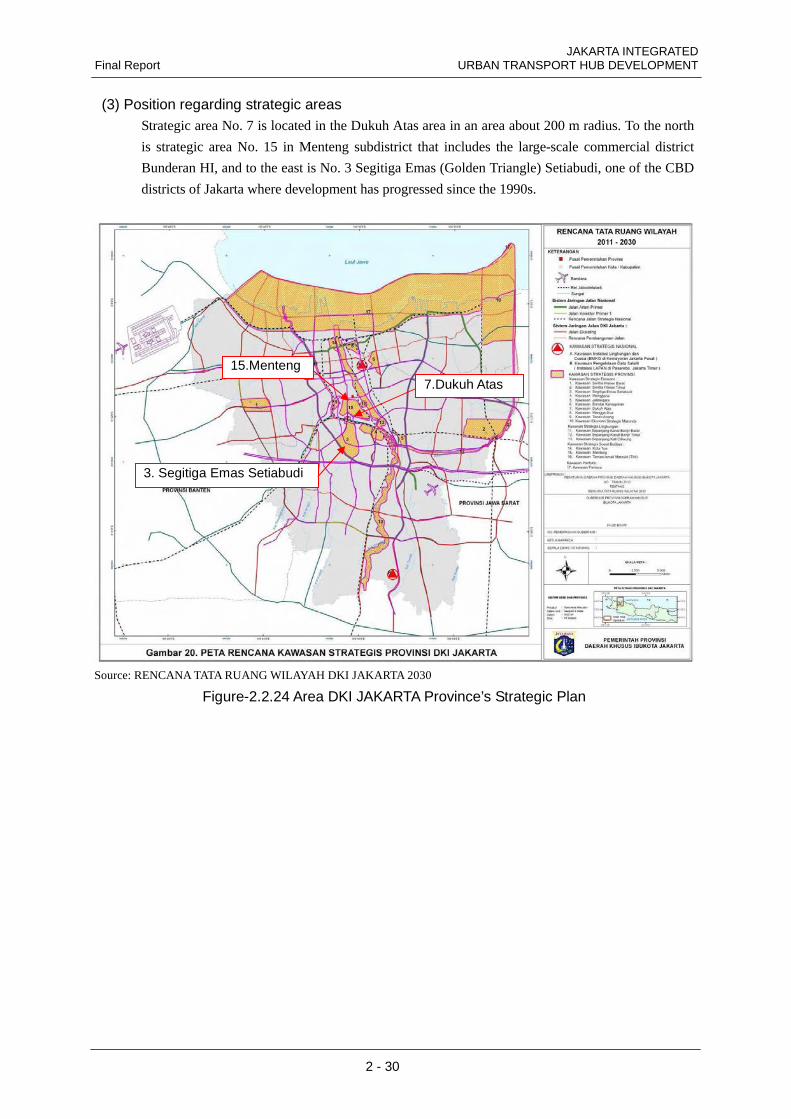
(3) Position regarding strategic areas Strategic area No. 7 is located in the Dukuh Atas area in an area about 200 m radius. To the north
is strategic area No. 15 in Menteng subdistrict that includes the large-scale commercial district
Bunderan HI, and to the east is No. 3 Segitiga Emas (Golden Triangle) Setiabudi, one of the CBD
districts of Jakarta where development has progressed since the 1990s.
Source: RENCANA TATA RUANG WILAYAH DKI JAKARTA 2030
Figure-2.2.24 Area DKI JAKARTA Province’s Strategic Plan
7.Dukuh Atas
3. Segitiga Emas Setiabudi
15.Menteng
JAKARTA INTEGRATED URBAN TRANSPORT HUB DEVELOPMENT Final Report
2 - 31
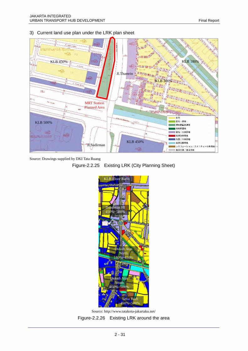
3) Current land use plan under the LRK plan sheet
Source: Drawings supplied by DKI Tata Ruang
Figure-2.2.25 Existing LRK (City Planning Sheet)
Source: http://www.tatakota-jakartaku.net/
Figure-2.2.26 Existing LRK around the area
Bunderan HI 450%~500%
Setia Budi 450%~500%
Dukuh Atas North
180%~450%
Dukuh Atas South
450%~500%
KLB Floor Ratio
KLB 300%
KLB 180% KLB 450%
KLB 500%
KLB 450%
Jl.Thamrin
Jl.Sudirman
MRT Station Planned Area

JAKARTA INTEGRATED Final Report URBAN TRANSPORT HUB DEVELOPMENT
2 - 32
At present in Dukuh Atas, the floor area ratios (KLB:Koefisien Lantai Bangunan) tend to be low
compared with the commercial and business center Bunderan HI subdistrict to the north on the
LRK (City Plan Sheet) and the commercial and residential high-rise center Setia Budi subdistrict
to the south.
The building area ratios (KDB: Koefisien Dasar Bangunan) are set to 40% to 60%, being set
lower the higher the floor area ratio (KLB:Koefisien Lantai Bangunan).
In particular in the north side of the Dukuh Atas area, business use is zoned for both sides of
Thamrin Road only, but areas away from the road are zoned as residential, so the floor area ratios
are low. Also, to the northwest of the area there are landacape restrictions in a part of the Menteng
subdistrict, which is a historical area.
Also, the planned site at MRT Dukuh Atas Station is currently zoned as a green area, so at
present there are no restrictions on floor area ratio and building area ratio. Likewise along the river
there are no restrictions on floor area ratio and building area ratio.

JAKARTA INTEGRATED URBAN TRANSPORT HUB DEVELOPMENT Final Report
2 - 33
4) Land ownership Most of the land ownership around the Dukuh Atas area is private. Land for roads is all managed
by the Jakarta Provincial Government. In the case of rivers, Banjir Kanal which flows east-west is
managed by the Ministry of Public Works, Directorate General of Water Resources, and rivers
flowing to the Menteng subdistrict in the northeast are owned by the Jakarta Provincial
Government PU.
The Jakarta Provincial Government owns the green strips on the two sides of rivers. Also, the
green area where the MRT Dukuh Atas Station is planned is owned by Jakarta Provincial
Government.
Other publicly owned land includes the approximately 3,000 m2 land where the public market
(PASAR BLORA) is located, which is owned by the public corporation PD PASAR JAYA, which
operates all the public markets.
Source: Study Team
Figure-2.2.27 Existing Landownership in Dukuh Atas
Banjir Kanal
N
Menteng
Planned
MRT
Station
Pasar
Blora
Private Land Public Land (PD PASAR JAYA) Public Land(DGR) Green Area/Park (DKI PW)
Water Body (MPW) Water Body (DKI PW)
Road (DKI PW)
JAKARTA INTEGRATED Final Report URBAN TRANSPORT HUB DEVELOPMENT
2 - 34
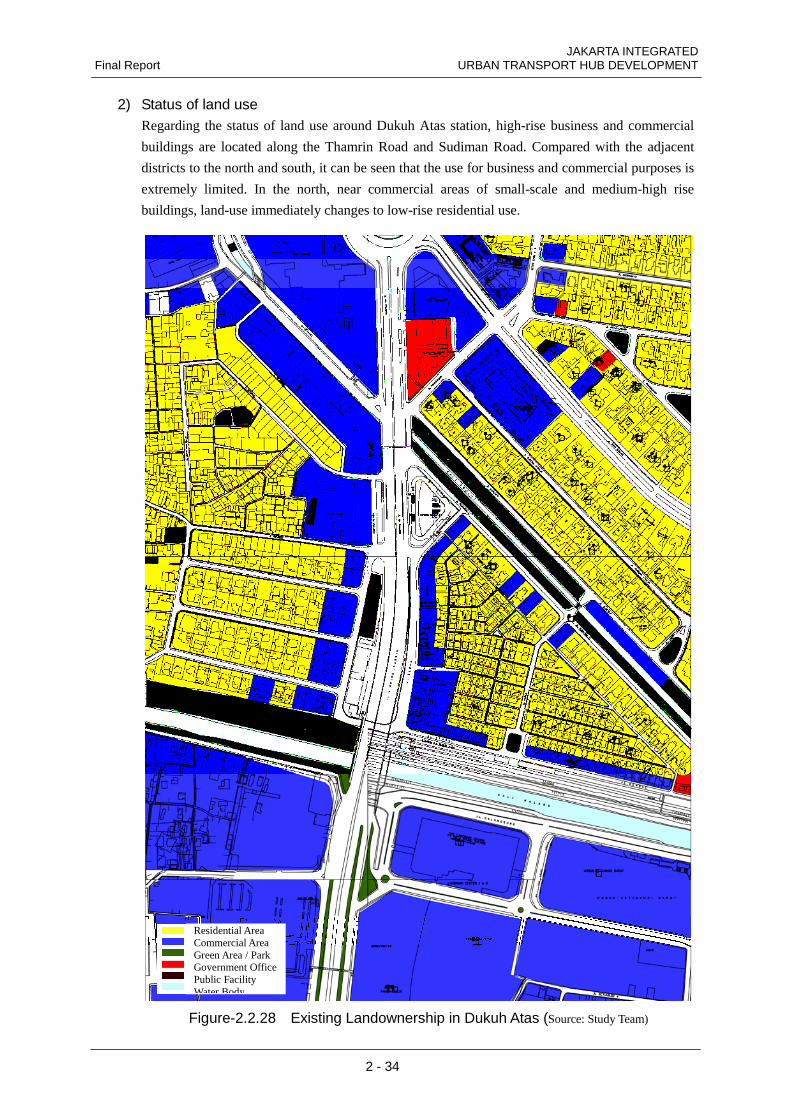
2) Status of land use Regarding the status of land use around Dukuh Atas station, high-rise business and commercial
buildings are located along the Thamrin Road and Sudiman Road. Compared with the adjacent
districts to the north and south, it can be seen that the use for business and commercial purposes is
extremely limited. In the north, near commercial areas of small-scale and medium-high rise
buildings, land-use immediately changes to low-rise residential use.
Figure-2.2.28 Existing Landownership in Dukuh Atas (Source: Study Team)
Residential Area Commercial Area Green Area / Park Government Office Public Facility Water Body

JAKARTA INTEGRATED URBAN TRANSPORT HUB DEVELOPMENT Final Report
2 - 35
6) Status of the surrounding buildings The status of the buildings in the Dukuh Atas area has been summarized below after surveying
their uses and number of stories (refer to Figure-2.2.12).
The status of the land use significantly differs on the east and the west side of Sudirman/Tamrin
Road. The west side comprises lots as large as about __## m2. In contrast, the east side is
characterized by dense distribution of extremely small lots Since no roads can be found to allow
access by vehicles, the east side poses a dangerous condition where disasters cannot be prevented.
(a) Use
In both the east and west areas, the lots facing a main street are often used as commercial
complexes and offices while the lots in the other areas consist mostly of dwelling houses.
(b) Number of stories
On Tanjung Karang Road west of Sudirman/Tamrin Road, buildings are four-story or higher and
the two building currently under construction are higher than 10-story. Mid-rise residences exist
only on lots along the railway tracks, and the other lots are occupied by single or two-story large
residences.
On Blora Road and Kendal Road east of Sudirman/Tamrin, three-story buildings are
conspicuous, with several mid-rise buildings standing on Blora Road. Some buildings currently
under construction can also be found. Buildings off the main streets are mostly single or
two-story structures.
(c) Construction type
Low-rise buildings are brick structures and mid-rise buildings are of reinforced concrete
construction. The mid-rise building being constructed on Blora Road east of Sudirman/Tamrin
Road is a steel structure.

JAKARTA INTEGRATED Final Report URBAN TRANSPORT HUB DEVELOPMENT
2 - 36
Figure-2.2.29 Existing Building in Dukuh Atas Area

JAKARTA INTEGRATED URBAN TRANSPORT HUB DEVELOPMENT Final Report
2 - 37
2.2.3 Details of surveys in past fiscal years In the past, the Dukuh Atas area has been considered to be a Transit Oriented Development (TOD)
potential model, from its position as a transport hub.
1) Former JBIC survey In July 2008, "Basic Survey concerning Railway Station Revitalization" which was commissioned
by JBIC, proposed initiatives aimed at revitalization of Dukuh Atas Station, as a model for the
solution of issues regarding stations in Indonesia.
In that survey, an outline survey of the status of Dukuh Atas Station surroundings was carried
out, and proposals for the development of the area focusing on the station were made, but it did not
indicate specifically how to proceed.
Source: JBIC “Basic Survey concerning Railway Station Revitalization" July 2008
Green area MRT (subway)
Pedestrian deck
Underground pedestrian walkway
Blora Road Bus/taxi bay • Bus bay • Taxi bay • Parking lot
Teg Karang Road
DML Kota Bumi Road
Width expanded to 4-lane road
New road
Station front plaza extension area
Future land development area
Future land development area
West side: 1F is Jabotabek railway
2F is airport access railway
East side: 1F is Jabotabek
railway Kendal Road
Galunggung Road
Sudirman Station Pedestrian deck
Sudirman Road
Expand width to 4-lane road
Monorail Station
Jabotabek railway Airport access railway
Commercial/business area
Commercial/business area
Important location
In order to facilitate access to both the north and south, a bus bay to be provided on both sides of Sudirman Road
Jabotabek Railway Station
Building
Twin Tower Station Building Shops catering to the daily shopping needs, and promotion of commercial development on both sides of the station
Waterway jetty Connects to railway and monorail stations by pedestrian decks
Composite station building Airport access railway: 3F level, Jabotabek railway: 1F level
Pedestrian deck to commercial buildings
Sudirman Road
Monorail Station (2F level)
Waterfront
Figure-2.2.30 JBIC survey proposals

JAKARTA INTEGRATED Final Report URBAN TRANSPORT HUB DEVELOPMENT
2 - 38
2) Dukuh Atas Station Interchange Competition In October and November of year 2008, The spatial planning agency of DKI Jakarta
(JAKARTA DKI TATA RUANG), together with the Indonesia Architect Institute hosted a
architectural competition “Sayembara Karya Stasiun Kereta Api Interchange Dukuh Atas 2008
(New Idea Competition for the Interchange Railway Station Dukuh Atas 2008), to gain new ideas
from the public (Limited to have at least one member of the Indonesian Architect Institute with an
architects license to be in the team) to implement to the current urban planning around the Dukuh
Atas area. The condition of the competition was to propose a design idea of integrate station for
the transport modes expected to come to Dukuh Atas in the future, which are the railway, MRT,
BRT, monorail , Airport line, and waterway transport. 3 winners were awarded, and the first
winner Mr. Yori Antars idea of multi later integration and roof top green building were
implemented to the existing

JAKARTA INTEGRATED URBAN TRANSPORT HUB DEVELOPMENT Final Report
2 - 39
Source: www.iai-jakarta.org/
Figure-2.2.31 Dukuh Atas Station Design Competition 2008

JAKARTA INTEGRATED Final Report URBAN TRANSPORT HUB DEVELOPMENT
2 - 40
3) Urban Transport Hub report of Dukuh Atas Based on the results of a competition in that year, Jakarta Provincial Government Planning Bureau
(JAKARTA DKI TATA RUANG) produced a report on future urban plan for the Dukuh Atas Station
surrounding area as a traffic hub “Panduan Rancang Kota Kawasan Dukuh Atas.” The report promotes
the TOD type of urban development, and for the Dukuh Atas area proposes a scheme to provide a large
public open space within a high floor area ratio area by forming a super block. The report itself was
not certified under the Spatial Plan law, and the plan was not implemented in the LRK city plan sheet.
Source: Panduan Rancang Kota Kawasan Dukuh Atas DKI 2008
Figure-2.2.32 Design Guidelines for Dukuh Atas District 2008 (1)
Figure-2.2.33 Design Guidelines for Dukuh Atas District 2008 (2) (Source: Panduan Rancang Kota Kawasan Dukuh Atas DKI 2008)

JAKARTA INTEGRATED URBAN TRANSPORT HUB DEVELOPMENT Final Report
2 - 41
Source: Panduan Rancang Kota Kawasan Dukuh Atas DKI 2008
Figure-2.2.34 Design Guidelines for Dukuh Atas District 2008 (3)
Source: Panduan Rancang Kota Kawasan Dukuh Atas DKI 2008
Figure-2.2.35 Design Guidelines for Dukuh Atas District 2008 (4)

JAKARTA INTEGRATED Final Report URBAN TRANSPORT HUB DEVELOPMENT
2 - 42
In the scheme in this report, to promote TOD, a scheme in which pedestrians have priority is
developed, and a network of pedestrian flow lines within the area is proposed. Also, open spaces
are planned as the entrance spaces to the area, and it is proposed that these be connected by the
pedestrian flow lines. Regarding transport facilities, the MRT, airport access line, BRT
(TransJakarta) Koridor 1, and at the 2008 stage Koridor 4 & 6 in the east direction had started
operation
Source: Panduan Rancang Kota Kawasan Dukuh Atas DKI 2008
Figure-2.2.36 Design Guidelines for Dukuh Atas District 2008 (5)
Open Space
Facility Entrance
Underground Passage
Arcade
JAKARTA INTEGRATED URBAN TRANSPORT HUB DEVELOPMENT Final Report
2 - 43
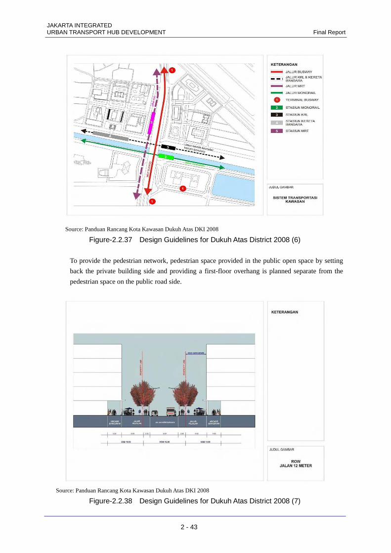
Source: Panduan Rancang Kota Kawasan Dukuh Atas DKI 2008
Figure-2.2.37 Design Guidelines for Dukuh Atas District 2008 (6)
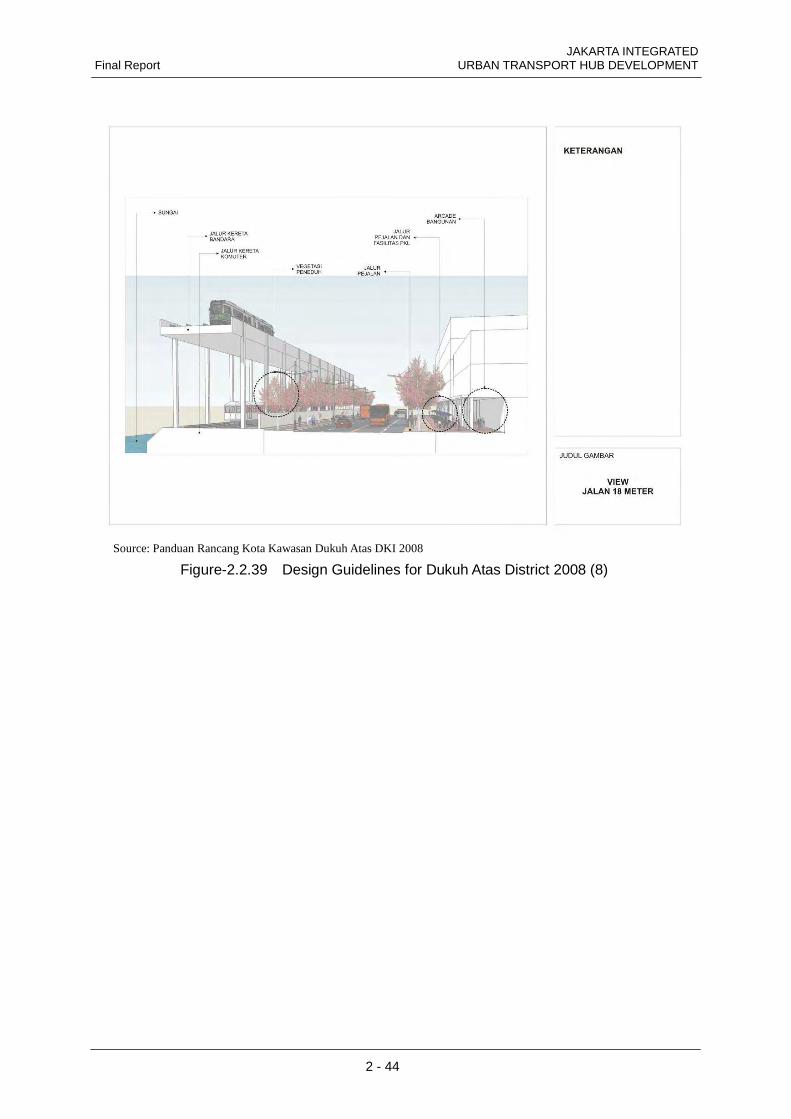
To provide the pedestrian network, pedestrian space provided in the public open space by setting
back the private building side and providing a first-floor overhang is planned separate from the
pedestrian space on the public road side.
Source: Panduan Rancang Kota Kawasan Dukuh Atas DKI 2008
Figure-2.2.38 Design Guidelines for Dukuh Atas District 2008 (7)
JAKARTA INTEGRATED Final Report URBAN TRANSPORT HUB DEVELOPMENT
2 - 44
Source: Panduan Rancang Kota Kawasan Dukuh Atas DKI 2008
Figure-2.2.39 Design Guidelines for Dukuh Atas District 2008 (8)

JAKARTA INTEGRATED URBAN TRANSPORT HUB DEVELOPMENT Final Report
2 - 45
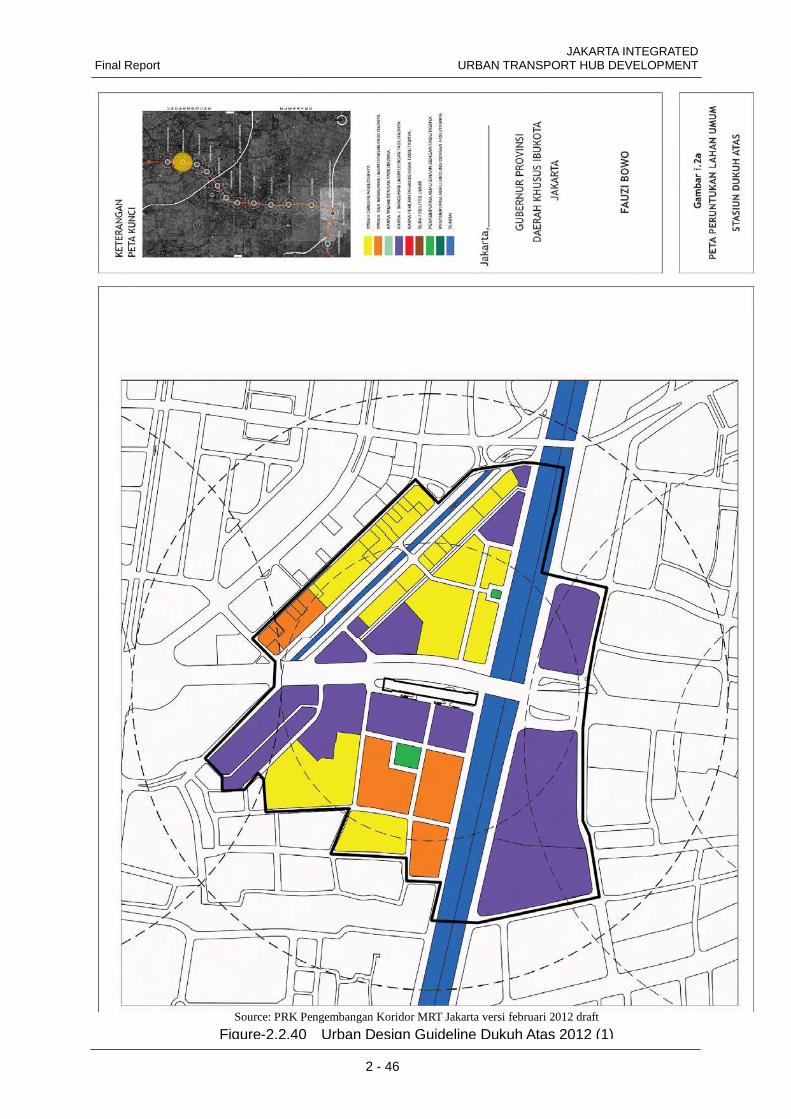
2.2.4 Current area development outlook 1) Outlook for land-use with the opening of MRT – Urban Design Guidelines The DKI Urban Planning Bureau is reviewing the LRK for land-use, floor area ratios, building
area ratios, etc., in an area extending to a radius of 500 m from the MRT station, in association
with the development of the MRT.
For this study of Dukuh Atas area, we respected the current undergoing study of the UDGL
done by the DKI Urban Planning Bureau, as the future vision of this area.
The undergoing UDGL study is based on the traffic hub report of “Panduan Rancang Kota
Kawasan Dukuh Atas” in 2008, respecting the usage of average 1ha super block planning. The
northern area of Dukuh Atas is planned to be raised to 600% KLB (Floor Area Ratio) from the
current 180%~450%. This study also respects this concept, of making high volume development on
north side aligning with the integration of the urban transport hub to be formed in the northern area.
Table-2.2.5 Urban Design Guideline Dukuh Atas 2012 (3) Source: PRK Pengembangan Koridor MRT Jakarta versi februari 2012 draft
JAKARTA INTEGRATED Final Report URBAN TRANSPORT HUB DEVELOPMENT
2 - 46
Source: PRK Pengembangan Koridor MRT Jakarta versi februari 2012 draft
Figure-2.2.40 Urban Design Guideline Dukuh Atas 2012 (1)

JAKARTA INTEGRATED URBAN TRANSPORT HUB DEVELOPMENT Final Report
2 - 47
Source: PRK Pengembangan Koridor MRT Jakarta versi februari 2012 draft
Figure-2.2.41 Urban Design Guideline Dukuh Atas 2012 (2)

JAKARTA INTEGRATED Final Report URBAN TRANSPORT HUB DEVELOPMENT
2 - 48
For other on going issues, Dukuh Atas has been placed as an area for TOD model, and the
compilation of the Urban Design Guideline is underway to ease mandatory parking
installations imposed on existing large development projects in Jakarta.
The issue of prime importance is an increase in ridership of public transport for both the
Railway Bureau of the Ministry of Transportation and the Indonesian railway company,
MRTJ, and there is no disagreement among the parties concerned on development to enhance
convenience for users such as transfer of trains among multiple lines which will be supported
by developing transfer circulations around Dukuh Atas Station. As regards MRT, although the
urban planning department holds its own image of planning for the areas around MRT stations,
it needs to be consistent with that of the DKI Urban Planning Bureau.
The DKI Transit Bureau, Transjakarta, has perceived problems in the current status of the
greater distance between Dukuh Atas Stations 1 and 2 and the insufficiency of station space
and connection passages for the large volume of users and has agreed on the transfer of buses
onto an artificial ground in view of the flow of users after the opening of the MRT north-south
line. The DKI Transit Bureau understands the policy on Dukuh Atas as the TOD area of the
DKI Urban Planning Bureau; it has raised a question, however, on the easement of the
mandatory parking installation in conjunction with the CAT function of the airport line.

JAKARTA INTEGRATED URBAN TRANSPORT HUB DEVELOPMENT Final Report
2 - 49
2.2.5 Future public transport plans As of 2012, Dukuh Atas is a transport hub where the railway West line and BRT (TransJakarta)
Koridor 1, Koridor 4, and Koridor 6 lines connect as major public transport.
In 2030, the MRT North-South line will be capable of transporting a large number of passengers
as an alternative to the BRT Koridor 1, and the area of influence of the railway station is expected
to expand. Also, the railway Loop line, the Serpong-Bekasi shortcut, and the Airport Express will
be completed, so the transport connections of Dukuh Atas will be capable of being accessed from
all directions of the city by public transport, thereby raising it as a major city center area.
Railway 750m radius
BRT 250m radius
Dukuh Atas
Bekasi
Serpong
Railway 750m radius MRT 500m radius BRT 250m radius
Dukuh Atas
Airport Express
Serpong Bekasi Short-Cut
Bekasi
Serpong
Loopline
Figure-2.2.42 Public Transportation Network in Year 2012 (Source: Study Team)
Figure-2.2.43 Public Transportation Network in Year 2030 (Source: Study Team)

JAKARTA INTEGRATED Final Report URBAN TRANSPORT HUB DEVELOPMENT
2 - 50
2.2.6 MRT plans Presently in this area, tendering for the detailed design of the Dukuh Atas Station (Intermediate
Underground Station) scheme of the Jakarta MRT north-south line of the Jakarta special provincial
urban expressway is in progress with Japanese ODA.
1) MRT north-south line Among the currently planned projects, only this project is making specific progress. The route has
been determined and in October this year construction order was placed for work section 6 . As a
Step project, it is planned that Japanese construction companies will participate in all the work
sections and that the work will proceed on a design/build basis. This will be Indonesia's first
underground railway, and will be a total of less than 24 km, from Lebak Bulus to Kampung
Bandan in the east via Jakarta Kota. (See Fig. 2.2.27.) Phase 1 will be the 15.7km section from
Lebak Bulus to Bundaran HI, and will include seven stations above ground, six stations below
ground. Construction will start in 2012 and operation is scheduled to start by the end of 2016.
Phase 2(from Bundaran HI to Kampung Bandan) is scheduled to open in 2018. The underground
railway is being designed as 1500V direct current with narrow gauge tracks 1067mm wide. It will
run north-south along Jakarta’s main road, Sudirman Road and Thamrin Road, and is expected to
greatly contribute to the development of the area around Dukuh Atas Station.
Figure-2.2.44 Underground Railway North-South Line
(Source: http://www.jakartamrt.com/)

JAKARTA INTEGRATED URBAN TRANSPORT HUB DEVELOPMENT Final Report
2 - 51
Source: Engineering Consulting Services for Jakarta Mass Transit System Project
Figure-2.2.45 MRT Dukuh Atas Station Basic Design Drawing
JAKARTA INTEGRATED Final Report URBAN TRANSPORT HUB DEVELOPMENT
2 - 52
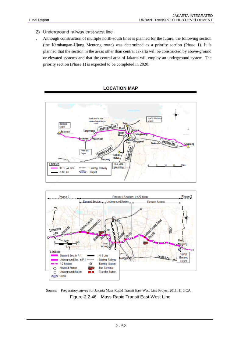
2) Underground railway east-west line . Although construction of multiple north-south lines is planned for the future, the following section
(the Kembangan-Ujung Menteng route) was determined as a priority section (Phase 1). It is
planned that the section in the areas other than central Jakarta will be constructed by above-ground
or elevated systems and that the central area of Jakarta will employ an underground system. The
priority section (Phase 1) is expected to be completed in 2020.
Source: Preparatory survey for Jakarta Mass Rapid Transit East-West Line Project 2011, 11 JICA
Figure-2.2.46 Mass Rapid Transit East-West Line