trail of blood - stanford university
TRANSCRIPT

spatial history lab1 April 2010
Trail of BloodThe Movement of San Francisco’s Butchertown and the Spatial Transformation of Meat Production, 1849-19011
Andrew Robichaud1
On a visit to New York City in 1842, Charles Dickens sketched a lively street scene on Broadway: the fashionable and well-to-do strolling up and down the wide streets, “ladies in bright colors walking to and fro, in pair and singly,” one with a blue parasol who “passed and repassed the hotel-window twenty times while we were sitting there.”2
But there was another living creature that caught Dickens’s eye; mixing with the ladies in bright clothes and parasols were “two portly sows,” and around the corner came a “half-a dozen gentlemen hogs.” Later in his travel account, Dickens observed a “solitary swine,” with one good ear, “having parted with the other to vagrant dogs.”3 Here, in the center of a growing and cosmopolitan metropolis—a fashionable part of one of the most fashionable American cities—were swine.
For much of the nineteenth century, American cities were ecologically diverse places, invariably made up of a multitude of domesticated and semi-domesticated species, including humans. But by the twentieth century that diversity was in decline, as people segregated and separated animals used for food production from growing commercial and residential downtowns. This new spatial separation between humans and certain animals transformed human-animal relationships, and the emerging paradigm fundamentally changed how people thought of their world. We continue to grapple with the consequences of that separation today, the contours and ramifications of which scholars have only begun to explore.4
During much of the nineteenth century, people in cities needed animals, even if their physical presence was at times offensive and unpleasant. Many urban residents kept pigs, who foraged the city streets by day before returning home each night for food scraps and shelter. For the poor, in particular, scavenger pigs were an inexpensive source of meat. Hog cart riots were common occurrences in New York City in the late 1820s and 1830s, as residents rebelled against city efforts to impound free-roaming pigs.5 By 1842, the year Charles Dickens visited New York, pigs still maintained a conspicuous presence in that city.6
Though pigs were less common in nineteenth century San Francisco, early accounts describe a multitude of species within the city. “The spaces separating these houses are filled with domestic animals,” wrote French journalist Etienne Derbec in the early years of the Gold Rush, “Horses, mules, sows, pigs, chickens live in freedom in these unusual sections [of town], and you, sir, can imagine all the inconveniences such a population brings in its train: one’s sense of smell and of hearing are, as you can well believe, somewhat offended.”7
1Graduate Lab Affiliate, Stanford University Spatial History Lab
©2010 Stanford University Spatial History Lab. All rights reserved1
The advent of railroads, wire communication and to so some extent refrigeration, changed the spatial possibilities of human-animal interactions. Railroads transformed spatial relations, making a seemingly distant area by human scale (out of sight, scent and sound) relatively close by a new industrial scale (the flow of capital, and the rapid movement of information and goods). A trip from the city’s outskirts to downtown markets by rail required a fraction of the time and cost it once did. Wire communication meant that a decision made in downtown San Francisco by someone on the stock market floor could be effected immediately by someone miles away on the kill floor. If distance were measured in terms of time spent and spoilage of goods, railroads caused a dramatic shrinkage of space. Later in the century, industrial use of ice and refrigeration had the effect of further collapsing distance and slowing time. Suddenly it was possible to ship regularly, quickly and inexpensively from hinterlands and outskirts to urban markets.8
Just as railroads created new connections between city and hinterlands—an urban center that magnetically pulled natural resources to concentrated markets—so also did railroads offer new opportunities to push away unwanted spaces. Railroads both connected and separated, creating an urban-periphery relationship that simultaneously pushed and pulled across the very same sets of tracks. Cities, including San Francisco, used this new spatial scenario as a regulatory tool.
In the remade landscape of a post-railroad world, the coexistence—often unpleasant—of animals and people in cities was no longer a necessary evil. Cities all over the world soon started exporting their noxious trades—chief among them slaughterhouses. One of the first things many cities did upon establishing a railroad was to export the messy process of killing and processing animals.9
The Urban Menagerie
The Case of San FranciscoThe case of San Francisco offers an interesting example
of this spatial transformation of meat production in the late nineteenth century. Using city directories and insurance maps to determine the locations of slaughterhouses and retail butcher shops—then mapping those places using GIS—we are able to see surprising spatial trends in meat production and distribution in the last decades of the nineteenth century. These trends would not be visible without using digital tools to breathe life into old documents.
Prior to 1867, slaughterhouses and retail butchers existed throughout San Francisco.
©2010 Stanford University Spatial History Lab. All rights reserved2
spatial history lab1 April 2010
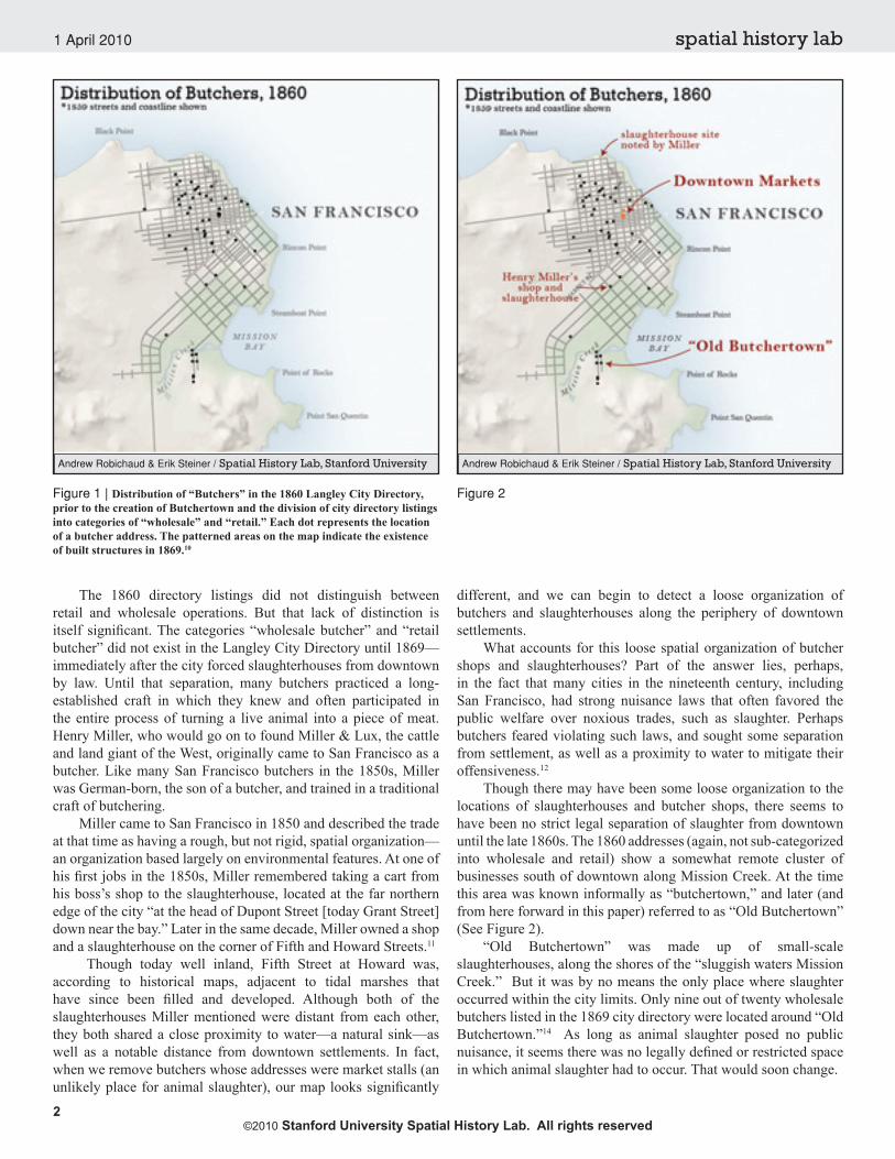
Figure 1 | Distribution of “Butchers” in the 1860 Langley City Directory, prior to the creation of Butchertown and the division of city directory listings into categories of “wholesale” and “retail.” Each dot represents the location of a butcher address. The patterned areas on the map indicate the existence of built structures in 1869.10
Figure 2
Andrew Robichaud & Erik Steiner / Spatial History Lab, Stanford University
The 1860 directory listings did not distinguish between retail and wholesale operations. But that lack of distinction is itself significant. The categories “wholesale butcher” and “retail butcher” did not exist in the Langley City Directory until 1869—immediately after the city forced slaughterhouses from downtown by law. Until that separation, many butchers practiced a long-established craft in which they knew and often participated in the entire process of turning a live animal into a piece of meat. Henry Miller, who would go on to found Miller & Lux, the cattle and land giant of the West, originally came to San Francisco as a butcher. Like many San Francisco butchers in the 1850s, Miller was German-born, the son of a butcher, and trained in a traditional craft of butchering.
Miller came to San Francisco in 1850 and described the trade at that time as having a rough, but not rigid, spatial organization—an organization based largely on environmental features. At one of his first jobs in the 1850s, Miller remembered taking a cart from his boss’s shop to the slaughterhouse, located at the far northern edge of the city “at the head of Dupont Street [today Grant Street] down near the bay.” Later in the same decade, Miller owned a shop and a slaughterhouse on the corner of Fifth and Howard Streets.11
Though today well inland, Fifth Street at Howard was, according to historical maps, adjacent to tidal marshes that have since been filled and developed. Although both of the slaughterhouses Miller mentioned were distant from each other, they both shared a close proximity to water—a natural sink—as well as a notable distance from downtown settlements. In fact, when we remove butchers whose addresses were market stalls (an unlikely place for animal slaughter), our map looks significantly
different, and we can begin to detect a loose organization of butchers and slaughterhouses along the periphery of downtown settlements.
What accounts for this loose spatial organization of butcher shops and slaughterhouses? Part of the answer lies, perhaps, in the fact that many cities in the nineteenth century, including San Francisco, had strong nuisance laws that often favored the public welfare over noxious trades, such as slaughter. Perhaps butchers feared violating such laws, and sought some separation from settlement, as well as a proximity to water to mitigate their offensiveness.12
Though there may have been some loose organization to the locations of slaughterhouses and butcher shops, there seems to have been no strict legal separation of slaughter from downtown until the late 1860s. The 1860 addresses (again, not sub-categorized into wholesale and retail) show a somewhat remote cluster of businesses south of downtown along Mission Creek. At the time this area was known informally as “butchertown,” and later (and from here forward in this paper) referred to as “Old Butchertown” (See Figure 2).
“Old Butchertown” was made up of small-scale slaughterhouses, along the shores of the “sluggish waters Mission Creek.” But it was by no means the only place where slaughter occurred within the city limits. Only nine out of twenty wholesale butchers listed in the 1869 city directory were located around “Old Butchertown.”14 As long as animal slaughter posed no public nuisance, it seems there was no legally defined or restricted space in which animal slaughter had to occur. That would soon change.
Andrew Robichaud & Erik Steiner / Spatial History Lab, Stanford University

Andrew Robichaud & Erik Steiner / Spatial History Lab, Stanford University
©2010 Stanford University Spatial History Lab. All rights reserved3
spatial history lab1 April 2010
The city would focus its first wave of new spatial regulations on “Old Butchertown,” and the slow, crimson creek that carried offal and blood to the Bay. Mission Creek did that work for years, until the accumulated and perpetual volume of bloody waste overtook the limited cleansing power the creek once held. Mission creek was no longer sufficient—both in its relationship to expanding residential settlement, and also in its capacity as an environmental sink facing the needs of a large and growing population.
Perhaps no American place grew as quickly into a major city as San Francisco in the nineteenth century. From 1860 to 1870 the city’s population increased by over 90,000 people—more than any other decade in its history besides the 1920s. As a percentage increase, the population tripled in the 1860s. By 1870, San Francisco was the tenth largest city in the United States.15
The new human pressures on the city’s environment in the 1860s were extraordinary. In 1866, the city’s Health Officer, J.M. McNulty, surveyed the sanitary situation, and expressed particular concern for “the close proximity of the Slaughter Houses and Hog Ranches to the City,” and their “great nuisance… so long as they remain in the present locality.”16 Two years later, in 1868, the problem persisted, and the Health Officer reported that the slaughterhouses located on the “sluggish waters of Mission creek,” required “two or three tides to carry the offal to the bay, where a great portion of it drifts in on our irregular water front, putrefying in the sun, and sending up its pestilential gases, poisoning the atmosphere of our city, and causing disease wherever it abounds.”17 Human activities of this booming city were rapidly outpacing the natural sink that was Mission Creek.
In addition to creating more waste, population growth also meant competition for space; the growing spheres of residential and noxious space clashed with greater frequency and intensity. In particular, the area south of Market Street, just north of “Old Butchertown” underwent rapid settlement in the 1860s. One factor in the development south of Market Street was the lapse in the city franchise on several toll roads in the 1860s, which opened Mission and Folsom Streets to greater traffic and development, and presumably made them more appealing to residential settlement.18
Geography had some influence on settlement patterns as well, with steep hills to the west of downtown limiting settlement, compared to the flat lowlands south of Market Street. It was soon clear, however, that the city’s growth made slaughterhouses in “Old Butchertown”—now only a few blocks south of the settlements south of Market Street—a permanent nuisance to the growing number of residential neighbors. What ensued was a turf war between competing aesthetics of space—a conflict between increasingly refined residential space and the new concentration and volume of urban waste. Residents complained about the stench and foulness in what one newspaper called a “war of the citizens on the butchers.”19
Inseparable from the stench of slaughter were health concerns that put additional pressure on the movement of slaughterhouses. The smell of rotting flesh was not merely unpleasant, but miasmatic theories held that those odors were unhealthy, even deadly. Further, new scientific evidence increasingly suggested that environments, and not God or an individual’s impiety, caused sickness and disease. By the 1860s, disease was not simply the
fault of an individual, but a social and environmental problem that could be solved by altering one’s surroundings. These ideas provided a stronger impetus for urban environmental reform.20
Public health was a powerful force in nineteenth century municipal politics. City governments often took seriously their task of protecting public welfare through a “well regulated society” under two common law maxims: salus populi suprema lex est (the welfare of the people is the supreme law), and sic utere tuo ut alienum non laedas (use your own so as not to injure another).21 Slaughterhouse regulation fell under the “Health Officer’s Report” in the city’s Annual Reports. By 1865 the San Francisco Department of Health was a powerful arm of city hall. Its muscle was the common law, which would enable the department’s rapid development in the decades that followed.
Slaughterhouses were not the only urban feature pushed toward the city’s outskirts. At the same time San Francisco started exporting slaughter, they also began exporting their dead. In 1868 the city exhumed bodies in cemeteries downtown and relocated them to the uninhabited “Outside Lands”—a windy and desolate collection sand dunes far west of the lively downtown. It was both fear of disease and the unremitting demand for residential urban space for the living that pushed cemeteries to the periphery—pressures not entirely different from those exerted on “Old Butchertown.”22
But slaughterhouses were held in space by a slightly different set of forces. Urban residents wanted them farther away than they actually were, but those same residents relied upon their close proximity. The railroad changed those spatial tensions—the pushes and pulls—holding slaughterhouses in place, effectively weakening the forces (spoilage and cost) that kept slaughter close. Slaughterhouses and other noxious trades, once spatially situated near the places they serviced, could now be connected to the city from farther away. It was possible enjoy a meal without smelling,
The Push on Slaughter
Figure 3 | Urban Development of San Francisco, 1853-1869. An illustration of the southern progression of the city around Mission Creek. (See p.8)

©2010 Stanford University Spatial History Lab. All rights reserved4
spatial history lab1 April 2010
Figure 4 | The stilted structures of Butchertown after massive damage from the 1906 earthquake. The slaughterhouses were designed so that offal would fall into the tide below.23
seeing, or hearing the process of turning animals into food.In the late 1860s, San Francisco passed a series of laws
that first banned slaughter from certain parts of the city, and ultimately established a particular, finite space for killing and keeping of animals that would become known as Butchertown. The initial push on slaughterhouses was accompanied by a “pull” from the southern shores of the city, a place that would become new Butchertown. The result was the consolidation of unwanted space, “Butchertown,” that was a piece of a larger separation and compartmentalization of the urban periphery.
The Nature of Slaughterhouse Space
A City Remade: The New Dynamics of Meat Production
Before it became slaughterhouse space, the marshes on the far southeastern side of the city were part of a 4,500-acre Mexican land grant to Jose Cornelio Bernal in 1839. The name of the grant was “Rincon de las Salinas y Potrero de Viejo”—“the corner of the salt marsh and the old grazing land.” The area had several key characteristics that made it stand out as potential slaughterhouse space. First, it was a place with little or no residential settlement and far from the growing residential areas of downtown. Second, it was a space recently connected to downtown by railroad and bridge, and thus pulled into economic orbit of the rapidly growing urban market. Third, it offered specific natural features that, in the eyes of nineteenth century planners, made it suitable for slaughterhouses.
The new abattoirs would be built on stilts with slatted floors, with the idea that slaughterhouse waste would drop into the tide below and washed away twice daily by the inexorable ebb and flow of salt water. It was a space of interaction between people and the natural environment—not one of domination or subversion, but a place where the built and natural environment, human work and ecological work, were expected to coexist.
Though San Francisco’s slaughterhouse district was somewhat distinctive for its tidal sink (most other cities had rivers), Butchertown was hardly unique. Specialized slaughterhouse space was an increasingly common feature of industrializing cities around the world. These places tended to have three key features: a new railroad, separation from downtown, and flowing water. Chicago, New Orleans, Paris, Berlin, and many other cities saw the emergence of similar versions of slaughterhouse space at around the same as San Francisco, though the forces in their creation might have varied.24 It seems likely that cities shared and borrowed knowledge to create these spaces. They were a specific type of space produced at a historical moment—the confluence of ideas of health and sanitation, urban population booms, and new spatial relationships made possible by the railroad.
By 1867, slaughter in San Francisco could only occur in an area defined by Kentucky Avenue, First Street, I Street, Seventh Street, and Railroad Avenues. Violators faced a fine of $20 to $500 and between twenty-five days and six months of prison for every infraction. Based on addresses, it would seem that wholesale butchers would take a few years to make the full transition to Butchertown, but the city no doubt came to enforce the new law. In 1867, one butcher challenged the law’s enforcement in an appeal that reached the California Supreme Court, and which ultimately upheld the legitimacy of Butchertown in Ex Parte Shrader.25
The new law creating Butchertown forced a spatial reconfiguration of meat production and sale. Wholesalers moved entirely out of “Old Butchertown” and split their operations between a small section of downtown, where they had offices, and new Butchertown, where they had slaughterhouses, stockyards and warehouses.
Spatial regulation of nuisances—particularly the regulation of something as noxious as slaughterhouses—was clearly within the rights of the city of San Francisco. An individual’s ownership of his own labor was not absolute; in the name of public welfare it could have spatial limitations. The urgency and widespread legitimacy of slaughterhouse regulation in the 1860s perhaps adds new context to the Slaughterhouse Cases that the Supreme Court would hear only several years later.26 One overlooked outcome of that important case was that it allowed cities to continue regulation of slaughterhouses under long-established precedent.
When the city created the new slaughterhouse reservation, the streets delineating Butchertown did not yet exist. If you were to stand on “First Street” in the southern part of the city, you would be knee deep in the bay. Most of Butchertown was not even dry land. In figure 5, the limits of Butchertown (in real space) are overlaid on an 1869 coastal survey map and a 1911 city map, showing Butchertown’s relationship to the Bay and downtown.
Just as the steep hills to the west of downtown San Francisco did not stop the city from overlaying its tidy grid of streets, so also did the bay offer no obstacle for the virtual “roads” that extended in straight lines into the concave tide. In the case of Butchertown, however, those watery roads were not necessarily meant to become land; the tidal flats were a critical feature of the new slaughterhouse space.

Figure 7 | Wholesale Butcher Locations, 1871-1901. New Butchertown and the spatial transformation of wholesale butchers. (See p.9)
©2010 Stanford University Spatial History Lab. All rights reserved5
spatial history lab1 April 2010
Figure 5 | An outline of Butchertown is imposed on an 1869 coastal survey. The newly created railroad, crossing Mission Bay and the mouth of Islais Creek, made Butchertown relatively close to downtown markets by commercial standards, while its physical location was far enough from settlement to mitigate nuisance.27
Figure 6 | Butchertown superimposed on The 1911 Chevalier map of San Francisco. City maps from the late nineteenth and early twentieth centuries usually showed the street grid extending into the Bay.28 San Francisco is also somewhat unique in that it allowed legal ownership of tidal bay lands.
Andrew Robichaud & Erik Steiner / Spatial History Lab, Stanford University
Mapping Meat Consumption
Andrew Robichaud & Erik Steiner / Spatial History Lab, Stanford University
While the keeping and slaughtering of animals contracted spatially and became increasingly invisible to urban residents, what happened to the spatial organization of meat sales and butcher shops? Mapping the addresses of the city’s “retail butcher” shops—where disembodied meat was sold to urban consumers—offers a surprising answer.
Mapping retail butchers shows their geographic expansion over time. But by mapping density, as shown in figure 8, we see a more important change in distribution. Though the number of retail shops in 1871 (244) increased only to 322 in 1886 and 299 in 1901, the distribution of those shops became more evenly spread across the city. No longer concentrated in specialized niches downtown (often market stalls), butcher shops spread across the city as stores in residential neighborhoods. No longer confined to downtown markets, meat hung in the windows of neighborhood stores, becoming integrated into the urban landscape. While certain living animals were becoming less a part of people’s lives, meat was increasingly imbedded in the everyday experience of city folk.30
Space and separation, then, intensified a new bureaucratization of the meat industry in San Francisco in the late nineteenth century. As butchers split their operations—to at once maintain their connections to downtown and Butchertown—so also did a split in the structure of their organizations emerge. In city directories, wholesale butchers increasingly listed their “offices,” which were not located at food markets, but rather in the financial district. Many butchers, like Henry Miller, turned in their bloody aprons for business suits, and went to work with bankers and brokers.29 The fashionable and well-to-do still mixed with animals downtown, as they had in Dickens’s time, though the physical connection between people and animals gave way to a more abstract relationship of commodification.

©2010 Stanford University Spatial History Lab. All rights reserved6
spatial history lab1 April 2010
Discussion and Question
Epilogue
Mapping historical data offers a new set of evidence with which to work. It raises many more questions than it ultimately answers.
The density maps of butcher shops raise a number of new questions. If there was, in fact, a decline in the number of butchers working out of market stalls, as the data suggests, what explains this apparent exodus from markets and into neighborhood shops? Was this new spatial organization connected to the creation of Butchertown and the parallel spatial transformation of the wholesale industry? Did the spatial changes in retail butcher shops have something to do with improved refrigeration and means of distribution? Furthermore, what were the consequences of this change? What did it mean socially that people increasingly shopped for meat at stores and not centralized markets? Was this movement of butcher shops part of a larger decentralization of commerce in general?
On larger level, why were 244 butcher shops needed to serve a population of about 160,000 in 1871, while a 1901 population of around 350,000 only needed 299 shops? Did consumption of meat decline, or (more likely) did individual shops sell at a higher volume? What were the mechanics of this transformation?
If we think of meat production—from pasture to hamburger—as a single system, a network, how might the movement of one piece of that network (the movement of slaughterhouses to Butchertown) change other parts of that system? And if we think of animals as part of a human intellectual network, what happens when certain species are removed from view?
San Francisco experienced a contraction and concentration of slaughterhouse and animal spaces in the late nineteenth century, along with a parallel spatial expansion of meat as a commodity. An urban resident living in 1901 saw living cows and pigs with far less frequency than someone in 1860, though human and animal lives remained invisibly tethered through a more abstract relationship of consumption.
As certain species were banned from cities, the diversity of people’s physical relationships with animals narrowed to mostly horses and dogs as transportation and pets—relationships qualitatively different than animal husbandry. Perhaps no coincidence, the first generation to grow up with disembodied
Figure 9
Andrew Robichaud & Erik Steiner / Spatial History Lab, Stanford University
Figure 8 | Retail Butcher Locations, 1871-1901. Spatial evolution of the butcher economy from concentrated to dispersed. (See p.10)
Andrew Robichaud & Erik Steiner / Spatial History Lab, Stanford University
Furthermore, how might we think of slaughterhouse regulation in the broader context of urban environmental reform? Slaughterhouses, tanneries, and cemeteries were among many urban features that became unwanted. What did this broader urban transformation look like, and what does the apparent compartmentalization of marginalized urban space add to our understanding of the relationship between city and hinterland?
Finally, for people living in San Francisco at the time, how was the lived experience in 1860 different from that in 1901? For one, urban residents in 1860 would have smelled, seen, and perhaps known the animals they consumed, while 1901 residents would have known fewer animals but been surrounded with butchered meat. What were the ramifications of those changes?

©2010 Stanford University Spatial History Lab. All rights reserved7
spatial history lab1 April 2010
meat and invisible slaughterhouses was the first generation to have their stomachs turned at Upton Sinclair’s descriptions of slaughterhouses on Chicago’s South Side decades later.
The separation of slaughter also separated the labor that accompanied it, and the invisibility of slaughterhouses enabled a glut of other offenses against animals and workers. “The slaughtering machine ran on, visitors or no visitors,” wrote Sinclair in 1906, “like some horrible crime committed in a dungeon, all unseen and unheeded, buried out of sight and of memory.”31 For years, cities like San Francisco had tried to make slaughterhouses “unseen,” “unheeded,” and “out of sight.” That was precisely the point—a healthier and more pleasant existence for urban residents in a modern city. With the strokes of a pen, Sinclair collapsed that cherished space, which had come to hide a world so grotesque as to cause a national outcry and a new agenda of reform.
As meatpacking operations increasingly turned to places like Baden (south of San Francisco) in the twentieth century, municipal regulations no longer applied. The City of San Francisco could no longer regulate the slaughterhouses that served its communities. A new spatial scale of production forced a shift in the scale of regulation, as the federal government took on slaughterhouses in the Progressive Era.
As slaughterhouses disappeared to city residents, retail butcher shops—once concentrated in city markets—spread like grapeshot throughout the city. Butcher shops and meat became more visible and a greater part of everyday life. Disembodied meat was normalized, and slaughter estranged.
The new separation was not random, however, and represented an attempt by cities to separate, concentrate, and order marginal or peripheral space. Slaughterhouses joined tanneries and cemeteries, and other types of spaces urban residents no longer wanted or needed close by. They were spatial diasporas that marked a new ordering of space. In many ways, this structuring of the periphery was shaped by environmental and democratic factors, effected by residential desires for a cleaner, healthier and more pleasant place to live.
Perched on the edge of Butchertown, where the tanneries once stood, today sits the Southeast Wastewater Treatment Plant, responsible for processing 80 percent of San Francisco’s wastewater. Though perhaps a powerful statement on the perpetuity of space devoted to industrial-scale waste, we would be hard pressed to find a more appropriate monument to Butchertown.
The French approach to reclaiming slaughterhouse space was more ironic; La Villette stands today transformed into a vast urban park, its grassy lawns bustling with picnics, strollers and soccer games. Residential aesthetics—at one time in conflict with slaughterhouse space—have reclaimed La Villette, once densely packed with the sounds and smells of animals, blood, and death. Americans, those that could, moved to the suburbs.

©2010 Stanford University Spatial History Lab. All rights reserved8
spatial history lab1 April 2010
Figure 3 extended | Urban Development of San Francisco, 1853-1869. An illustration of the southern progression of the city around Mission Creek.

©2010 Stanford University Spatial History Lab. All rights reserved9
spatial history lab1 April 2010
Figure 7 extended | Wholesale Butcher Locations, 1871-1901. New Butchertown and the spatial transformation of wholesale butchers.

©2010 Stanford University Spatial History Lab. All rights reserved10
spatial history lab1 April 2010
Figure 8 extended | Retail Butcher Locations, 1871-1901. Spatial evolution of the butcher economy from concentrated to dispersed.

©2010 Stanford University Spatial History Lab. All rights reserved11
spatial history lab1 April 2010
Supplementary Information is linked to the online version of the paper at http://spatialhistory.stanford.edu/publications.
Ninth U.S. Census data in Robert Cherny and William Issel, San Francisco: 1865-1932: Politics, Power, and Urban Development (Berkeley: University of California Press, 1986) 24.SFMR 1865-1866, 235.SFMR 1867-1868, 284-5.Roger Olmsted and Nancy Olmsted, Rincon de las Salinas y Potrero Viejo—the Vanished Corner (San Francisco: San Francisco Clean Water Management Program, 1981) 219; Roger Lotchin, San Francisco, 1846-1856: From Hamlet to City (New York: Oxford, 1974) 169; William Crittenden Sharpsteen, “Vanished Waters of Southeastern San Francisco,” California Historical Society Quarterly, 21 no.2 (Jun., 1941), online: www.sfmuseum.org/hist5/vanish.html (accessed 12/17/09).“Butchertown War Resumed,” California Daily Alta, 4 June 1868: 1.For a more detailed discussion on changing ideas of health and the environment, see Martin V. Melosi, The Sanitary City: Urban Infrastructure in America from Colonial Times to the Present (Baltimore: Johns Hopkins University Press, 2000) as well as Rosenberg, The Cholera Years.See Novak, The People’s Welfare: Law and Regulation in Nineteenth-Century America, introduction.Tamara Shelton Venit, “Unmaking Historical Spaces,” California History, 85 no. 3 (2008), p.32.Butchertown. [Ruined Piers.],” 1906, Photograph, Berkeley, CA, Bancroft Library, The 1906 San Francisco Earthquake and Fire Digital Collection, http://www.oac.cdlib.org/ark:/13030/hb5j49p27w/?brand=oac4.See Meat, Modernity, and the Rise of the Slaughterhouse, ed. Paula Young Lee (Durham, NH: University of New Hampshire Press, 2008).Ex Parte Shrader, 33 Cal. 279, 1867 WL 694 (Cal).Ronald Labbe and Jonathan Lurie have offered an important new look at the context of the Slaughterhouse Cases. See Ronald M. Labbe and Jonathan Lurie, The Slaughterhouse Cases: Regulation, Reconstruction, and the Fourteenth Amendment (Lawrence: University of Kansas Press, 2003).“San Francisco Peninsula. United States Coast Survey, 1869.” http://www.davidrumsey.com/maps407.htmlAugust Chevalier, “The “Chevalier” Commercial, Pictorial and Tourist Map of San Francisco From Latest U.S. Gov. and Official Surveys,” from http://www.davidrumsey.com/maps6460.html (accessed 12/17/09).See “Banks” and “Brokers” in 1886 and 1901 San Francisco Directory.On a separate note, butcher shops might stand as a highly accurate proxy for settlement, since people did not travel far to buy meat. Since we do not yet have mapped population data for San Francisco in the nineteenth century, butcher shops may offer a decent place marker.Upton Sinclair, The Jungle (New York: Doubleday, Page & company, 1906) 41.
15.
16.17.18.
19.20.
21.
22.
23.
24.25.
26.
27.
28.
29.
30.
31.
This article should be read as an exploration—a starting point more than a complete project. That will soon become clear to the reader. Indeed, one of the exciting parts of making maps and creating new evidence for analysis is that it raises more questions than it answers. Creating maps often opens up new sets of questions for the historian to take to the archives. I welcome your feedback and suggestions, which can be emailed to [email protected]. I would like to thank Jon Christensen for supporting and engaging this project, along with Richard White and Zephyr Frank for valuable feedback at various points. Errors belong to me entirely. Spatial history is impossible without collaboration. My greatest thanks goes to Erik Steiner who produced the final visualizations and offered valuable feedback along the way. Thanks also to the Spatial History Lab team, especially Kathy Harris and Whitney Berry. David Rumsey’s website, davidrumsey.com, provided digitized historical maps used throughout. His commitment to making those maps free and easy to use online has been an enormous asset to this and other projects.Charles Dickens American Notes, as reprinted in Fireside Dickens. (London: G. W. Carleton, 1883) 362.Dickens 362.Two historical works of note are Harriet Ritvo, The Animal Estate (New York: Harvard, 1987) and Richard Bulliet, Hunters, Herders and Hamburgers (New York: Columbia, 2005). Katherine Grier, Pets in America: A History (Chapel Hill: University of North Carolina, 2006) 351, FN 69. Charles Rosenberg The Cholera Years (Chicago: University of Chicago Press, 1987) 113.Dickens 362.Abraham Nasatir, ed. A French Journalist in the California Gold Rush: The Letters of Etienne Derbec (Georgetown, California: The Talisman Press, 1864) 170.See William Cronon, Nature’s Metropolis (New York: Norton, 1991).See Meat, Modernity, and the Rise of the Slaughterhouse, ed. Paula Young Lee (Durham, NH: University of New Hampshire Press, 2008). Data points based on business listings in the Langley San Francisco City Directory (San Francisco: Langley, 1860). The Map, “San Francisco Peninsula. United States Coast Survey, 1869,” was produced by the United States Coast Survey and downloaded from http://www.davidrumsey.com/maps407.html (accessed 12/17/09). Data points for all of the maps in this paper were created with the help of the online program www.batchgeocode.com. City directory addresses were compiled in a spreadsheet, then processed through batchgeocode and turned into spatial points compatible with GIS. Points were then double-checked for accuracy (there were glitches) and some points had to be adjusted to match nineteenth-century block numbers (most address and block relationships remained constant through the years, though changes can be found at the front street index of each year’s city directory).Henry Miller, “Dictation of Henry Miller, Esq.” Miller was interviewed for Hubert Bancroft’s Chronicles of the Builders of the Commonwealth. Bancroft Library, MSS C-D 791. For a broad discussion of municipal nuisance laws and their widespread use in the nineteenth century cities, see William Novak, The People’s Welfare: Law and Regulation in Nineteenth-Century America (Chapel Hill: University of North Carolina Press, 1996) San Francisco Municipal Reports (SFMR), 1867-68, 284-285.Langley San Francisco Directory, 1869.
1.
2.
3.4.
5.
6.7.
8.9.
10.
11.
12.
13.14.