trail shrines in native american rock art - … · trail shrines in native american rock art in...
TRANSCRIPT
Galal R. Gough
TRAIL SHRINES IN NATIVE AMERICAN ROCK ART
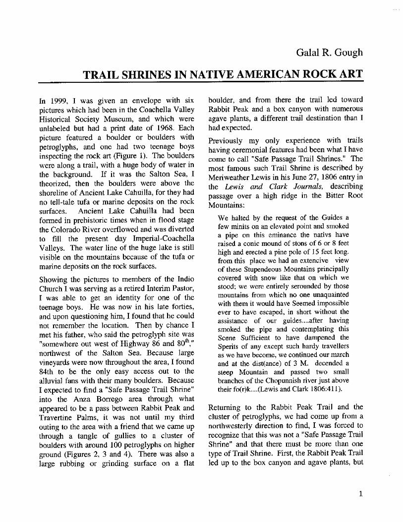
In 1999, I was given an envelope with six pictures which had been in the Coachella Valley Historical Society Museum, and which were unlabeled but had a print date of 1968. Each picture featured a boulder or boulders with petroglyphs, and one had two teenage boys inspecting the rock art (Figure 1). The boulders were along a trail, with a huge body of water in the background. If it was the Salton Sea, I theorized, then the boulders were above the shoreline of Ancient Lake Cahuilla, for they had no tell-tale tufa or marine deposits on the rock surfaces. Ancient Lake Cahuilla had been formed in prehistoric times when in flood stage the Colorado River overflowed and was diverted to fill the present day Imperial-Coachella Valleys. The water line of the huge lake is still visible on the mountains because of the tufa or marine deposits on the rock surfaces.
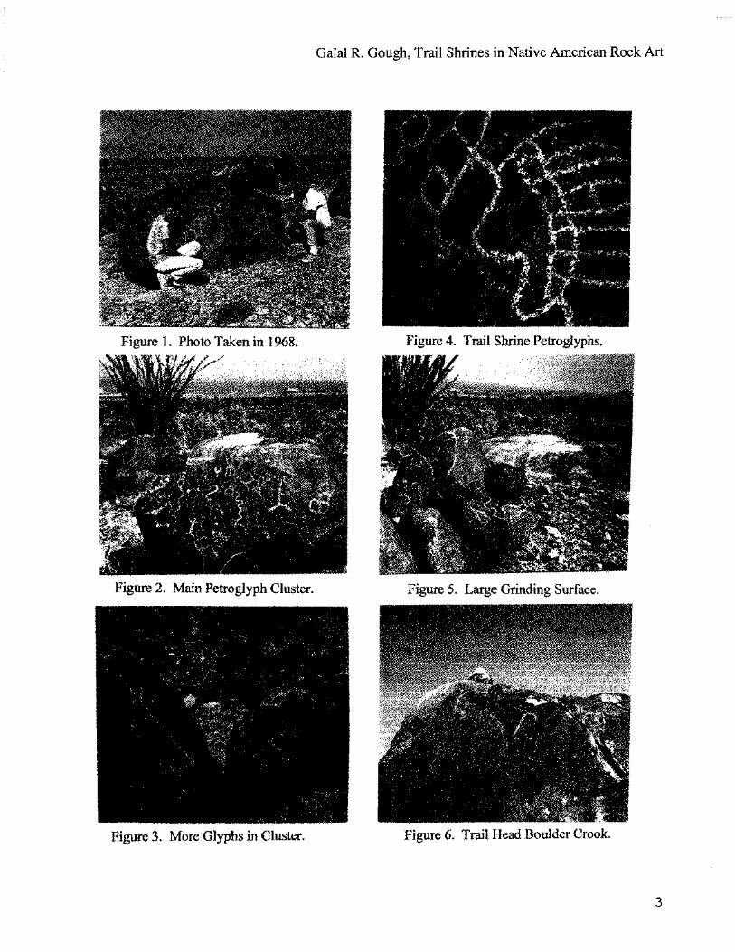
Showing the pictures to members of the Indio Church I was serving as a retired Interim Pastor, I was able to get an identity for one of the teenage boys. He was now in his late forties, and upon questioning him, I found that he could not remember the location. Then by chance I met his father, who said the petroglyph site was "somewhere out west of Highway 86 and 80 th," northwest of the Salton Sea. Because large vineyards were now throughout the area, I found 84th to be the only easy access out to the alluvial fans with their many boulders. Because I expected to find a "Safe Passage Trail Shrine" into the Anza Borrego area through what appeared to be a pass between Rabbit Peak and Travertine Palms, it was not until my third outing to the area with a friend that we came up through a tangle of gullies to a cluster of boulders with around 100 petroglyphs on higher ground (Figures 2, 3 and 4). There was also a large rubbing or grinding surface on a flat
boulder, and from there the trail led toward Rabbit Peak and a box canyon with numerous agave plants, a different trail destination than I had expected.
Previously my only experience with trails having ceremonial features had been what I have come to call "Safe Passage Trail Shrines." The most famous such Trail Shrine is described by Meriweather Lewis in his June 27, 1806 entry in the Lewis and Clark Journals, describing passage over a high ridge in the Bitter Root Mountains:
We halted by the request of the Guides a few minits on an elevated point and smoked a pipe on this eminance the nativs have raised a conic mound of stons of 6 or 8 feet high and erected a pine pole of 15 feet long. from this place we had an extencive view of these Stupendeous Mountains principally covered with snow like that on which we stood; we were entirely serounded by those mountains from which no one unaquainted with them it would have Seemed impossible ever to have escaped, in short without the assistance of our guides....after having smoked the pipe and contemplating this Scene Sufficient to have dampened the Sperits of any except such hardy travellers as we have become, we continued our march and at the dist(ance) of 3 M. decended a steep Mountain and passed two small branches of the Chopunnish river just above their fo(r)k....(Lewis and Clark 1806:411).
Returning to the Rabbit Peak Trail and the cluster of petroglyphs, we had come up from a northwesterly direction to find, I was forced to recognize that this was not a "Safe Passage Trail Shrine" and that there must be more than one type of Trail Shrine. First, the Rabbit Peak Trail led up to the box canyon and agave plants, but
1

Utah Rock Art, Volume 23, 2003
went no farther. Second, prominent among the petroglyphs was the flat boulder with huge metate or grinding surface (Figure 5), which I will later comment on as "agave fiber rubs." This led me, regarding the question of Trail Shrine Typology, to believe we had stumbled upon a "Harvest Trail Shrine." This conviction was further reinforced by an ethnographic reference to hunting trails, food gathering trails and safe passage trails, for Chief Francisco Patencio had written in his Stories and Legends of the Palm Springs Indians:
The trails of the Indians were everywhere. They led up all the canyons. There were hunting trails for the men, and used by women to gather the seed, nuts, plums, and acorns, so many things. They led from the land of one tribe to another. All the Indians did their part to keep the trails clear. The trails were sacred to the Indians (Patencio 1943: 70).
Then following the trail back on level sloping terrain, we passed three more clusters of petroglyphs before reaching the initial petroglyphs on the trail, featured in the six pictures taken in 1968. Nearby was a large boulder with a crook petroglyph (Figure 6). Because of the widespread incidence of the shaman's crook in Native American Rock Art across the Southwest, and the writings of Carabeth Laird dealing with the great powers attributed to the Shaman's crook, and as "the shaman's badge of office" (Laird 1976:31), I believed the crook petroglyph, though appearing to be more recent, indicated a perception that the Rabbit Peak Trail Shrine was a site of a powerful harvest ceremony.
The Clark Lake petroglyph site at the southern base of the Santa Rosa Mountains, located east of Rockhouse Canyon, has a number of rubbing surfaces (Figure 7) along the Petroglyph Trail. Lowell John Bean, Sylvia Brakke Vane and Jackson Young, in The Cahuilla Landscape: The Santa Rosa and San Jacinto Mountains,
describe the site and the "agave fiber rubs," as follows:
The petroglyphs, which have been interpreted as being of an early Cahuilla type, are pecked into the reddish-brown patina of the boulders, which spread out for a hundred feet along the Clark Lake Petroglyph Trail.... There are agave fiber rubs associated with the petroglyphs (Bean, Vane and Jackson 1991:44).
This petroglyph site (Figure 8) along with the agave fiber rubs contributed to the recognition of more than one type of trail shrine, and the need to consider Harvest Trail Shrines and multiple use trails in investigating Trail Shrine Typology.
The most common Trail Shrine type, as illustrated by the Meriweather Lewis quote, is the Safe Passage Trail Shrine. In Pipes Canyon, located northwest of present day Yucca Valley, California, a Trail Shrine marks a prehistoric route from the desert up into the San Bernardino Mountains. On an outcrop of rock (Figure 9) there are three petroglyph panels (Figure 10).
Just beyond the outcrop, the trail, with a cairn on either side, moves up onto a higher shelf to avoid a marsh area farther upstream. The Trail Shrine and cairns initiate the climb up into the mountains.
A classic desert Safe Passage Trail Shrine is east of Corn Springs and southeast of Desert Center, California. As the trail moves out into the desert for the long trek to McCoy Springs, there is a petroglyph-covered boulder (Figure 11) followed by a large cairn (Figure 12), where offerings were made for safe passage through the long hot dry desert expanse. Unfortunately, the cairn has been disturbed, perhaps by mis-guided pothunters who have no respect or knowledge. Chief Patencio, commenting on the practice of putting a pile of rocks by the side of a trail, said: "This pleased the spirits, and caused goodwill" (Patencio 1943: 73).
2
Fi pure 3. More Glv rhs in. Cluster. Figure Trail Head Boulder ook.
Figure 4. Trail Shrine etroglyphs.
Galal R. Gough, Trail Shrines in Native American Rock Art
3
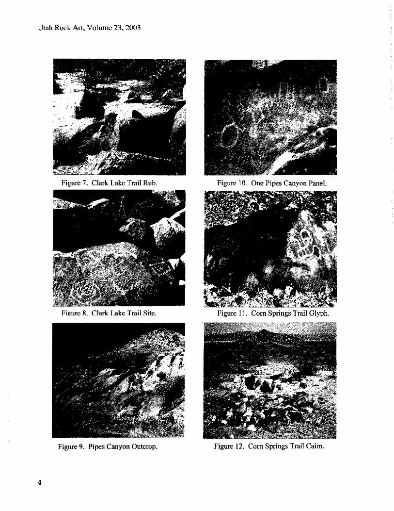
Figure 7. Clark Lake Trail Rub.
Utah Rock Art, Volume 23, 2003
Figure 9. Pipes Canyon Outcrop. Figure 2 Corn Springs Trail Calm.
4

Galal R. Gough, Trail Shrines in Native American Rock Art
In the Turtle Mountains, northwest of Vidal Junction, California, according to a listing of sites, I had read of petroglyphs near Mopah Spring. However, after hiking to the spring, nestled by a palm tree, I found only potsherds and flakes near a ridge and small shelters, but no petroglyphs. A year or so later, when a couple with a plane asked me to show them the giant intaglios or desert figures along the Colorado River, I asked them to fly over the Turtle Mountains on the way home. From the air I could see a trail on the other side of a ridge from the spring. Going back, I followed the trail (Figure 13) up to a saddle where there was an intersection of trails, along with a trail guardian petroglyph (Figure 14), a large cairn and other petroglyphs at this major Trail Shrine.
Farther north, in the Mojave National Preserve, a trail from Soda Dry Lake over a volcanic ridge to Cow Cove goes right straight up to the crown of the ridge (Figure 15). At the crest of the climb is a group of petroglyphs (Figure 16). Below the steep incline wagon ruts follow the trail, but veer to the right to switch back up the ridge. But the trail to the petroglyphs goes straight up the incline, as some Indian trails do. But while I have no ethnographic data on this site, I found the description in Rock Art of the Southwest: A Visitor's Companion, by Liz and Peter Welsh, to be very provocative:
TRAILS are associated with some rock-art sites. In some cases, the trails are routes through canyons and passes. In other cases, they are straight cleared paths that lead directly up a slope-paths with no switchbacks, which makes them hard to climb. Researchers think it is unlikely that these were for ordinary travel; they may have been used in strenuous activities that were part of certain rituals (Liz and Peter Welsh 2000: 36).
A nearby rock shelter and rock aligned desert pavement add to the mystery about the meaning of the site.
Two trails in Arizona start east from the prehistoric Colorado River crossing near present day Bullhead City, with one heading out toward Secret Pass. This more northerly route along Fox Creek has a cluster of petroglyphs, including a unique boulder glyph (Figure 17), and the site is known by some researchers as the Fox Creek Trail Shrine. A huge cairn with many hundreds of offering rocks (Figure 18) appears also to have had a pathway or dance circle around it. The trail continues to the east along Fox Creek (Figure 19), and in another view of the cairn the trail is visible on the far slope (Figure 20) leading toward Secret Pass.
The other trail is farther south and also has petroglyph markers (Figure 21) and a huge trail shrine cairn (Figure 22). This trail is known as the Mohave Road, with the Arizona spelling, and has important historical references. Father Francisco Garces in 1776 recorded his journey east into present day Arizona in his diary, which provides the source for the account in Clifford Walker's book, Back Door to California: The Story of the Mojave River Trail:
In order to complete his goal of a route from California to New Mexico, Garces headed east from the Mohave villages, crossing the Colorado River on June 5. The Yavapai treated him favorably as he crossed their territory in Arizona, and they guided him to the Hopi pueblo of Oraibi... To reach California from New Mexico, Garces not only mentioned the direct route from Zuni to the Mojave River Trail, but also a route around the northern part of the Grand Canyon. With the Anza or Yuma route to California a fact, and the direct route from New Mexico, following the Indian trails across Arizona and the Mojave Desert a visible possibility (Walker 1986: 80-81).
Garces had shown the dream of so many for a New Mexico to California route could soon be a reality.
5

Utah Rock Art, Volume 23, 2003
Igure 15. Trail Up Ridge.
6

Galal R. Gough, Trail Shrines in Native American Rock Art
Figuto 21 donave Petroglyphs. Figure v10 r MohaNc Read GI .'p s.
7

Utah Rock Art, Volume 23, 2003
It is uncertain from the Garces diary whether his route was the Fox Creek Trail through Secret Pass, or the Mohave Road. But the role of the Mohave Road in later American history is well documented. In 1863 Captain Henry M. Enos was ordered to find a practical wagon road from Fort Whipple near present day Prescott to the Colorado River, and, according to Dennis Casebier, chose the route
...originally known as the 'Irataba trail' being named for the Mohave chief who was the first to lead immigrants from California with their wagons over the route. In December of 1863 and January of 1864, Enos, a captain in the quartermaster's department from New Mexico, conducted an exploration over the route and reported it to be practical for wagons (Casebier 1975:138).
While wagons followed the Indian trail, there are stretches where the original trail is still visible near the Mohave Road (Figure 23). Clusters of petroglyphs and broken pottery are found along the road, as well as isolated petroglyph boulders (Figure 24) over many miles as the Mohave Road approaches the mountain pass.
The huge trail shrine cairns, where stone offerings were made over extensive periods of time, suggest an important ritual related to passage through desert and mountain expanses. Grace Burkholder in an article entitled "Something to Think About," in the Nevada Archaeologist, asks questions regarding the Safe Passage Trail Shrines. For example:
Did Native Americans use trail markers or were petroglyphs placed along a trail to insure a safe journey?...the glyphs could have represented small shrines where travelers paused for a few minutes rest or to ask the guardian spirits for a safe journey (Burkholder 2000: 9).
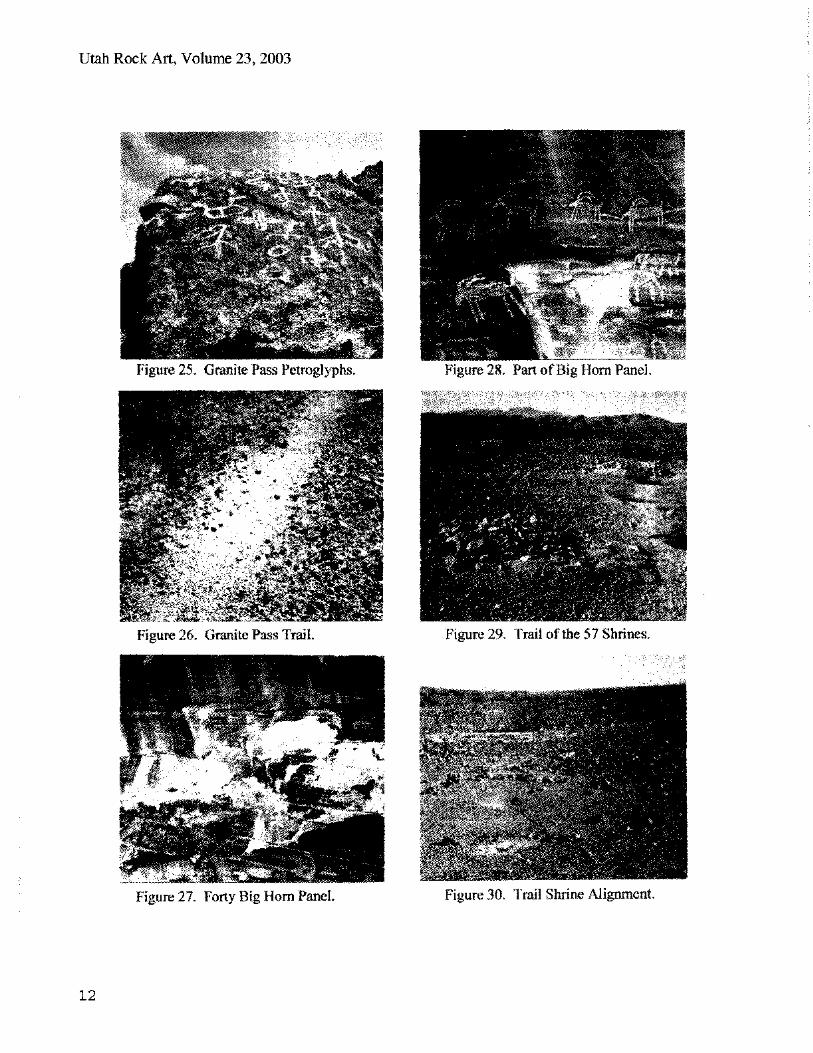
Another Trail Shrine in Western Arizona is located in Granite Pass, between Vicksburg and Salome. A tall boulder complex with petroglyphs (Figure 25) marks the Granite Pass
Trail Shrine. There are bedrock mortars on the back side, and though the old road and newer highway disrupt the area, farther to the east an Indian trail (Figure 26) leads toward the site. (The trail measures 15 inches across, and I call it an Indian trail because years ago Ike Eastvold, who in more recent years has devoted himself to the establishment and protection of Petroglyph National Monument, New Mexico, told me during an outing in the Mojave, and I think I have it right, that a game trail is about 9 or 10 inches wide, an Indian trail 14 or 15 inches wide, and a mule trail 22 inches wide.)
In Southern Nevada, between the Whitney-Hartman and Kohta's Circus sites southwest of Mesquite, there is a Forty Bighorn panel (Figures 27 and 28). The trail continuing in a southerly direction from the panel toward a spring has hunting blinds overlooking the route big horn would take to drink. The petroglyph site fits the requirements of a Hunting Trail Shrine. In the Fall 1996 La Pintura, Pat McCreery takes "Another Look at Hunting Magic" and observes that in preparation for the book, Tampamveni, Ekkehart Malotki discovered and photographed eight petroglyph hunting panels. McCreery concludes on the basis of his research with Palavayu data, and the research of others, that hunting success was a motivating factor in both ritual and petroglyph depictions of hunt and game images (McCreery 1996: 6-8). My less ambitious goal is simply to chronicle a third type of Trail Shrine, namely, the Hunting Trail Shrine.
The fourth type of Trail Shrine, because of sleeping circles and other indications of ritual taking place over a period of days, I am calling the Sacred Gathering Trail Shrine. The first example is the "Trail of the 57 Shrines" on Bee Rock Mesa, discovered by Paul Wilhelm and described in the June 1951 issue of Desert Magazine. Located across from the Thousand Palm Oasis, the trail has 57 cairns (Figure 29), along with rock alignments, (Figure 30) sleeping circles (Figure 31) and possible dancing areas.
8
Galal R. Gough, Trail Shrines in Native American Rock Art
Wilhelm notes the "record number of rock mounds-Trail Shrines of the ancient Indians who once camped" at the Thousand Palms Spring (Wilhelm 1951). The sleeping circles, I believe, indicate a shrine with ceremonial activity lasting two or more days.
Another ceremonial site where individual sleeping areas would indicate activity over several days is Bourke's Intaglio, also called Merryman's Circular Pathway, located along the Needles to Laughlin Highway south of the old Von Schmidt Nevada Border Marker. Bourke describes the large pile of stones and the dance circle farther to the west (Figure 32) used in the Boy's Puberty or Coming of Age Initiation. The numerous individual sleeping pads north and west of the intaglio (Figures 33 and 34) would suggest that the enactments around the dance circle (Bourke 1889:171-174) and the training for the responsibilities of manhood, lasted for several days, again qualifying this site as being a Sacred Gathering Trail Shrine.
Bourke's Intaglio is along the Xam Kwatcan Trail, which leads up the Colorado River about two hundred miles from the cairns, ceremonial circle and Trail Shrine petroglyph panel at Pilot Knob or Avikwalal, across from present day Yuma, north to Spirit Mountain or Avikwaame, the "Mountain of Creation." Other well-known ceremonial sites, like Black Point and the Blythe Intaglios, are also along the Xam Kwatcan Trail. But some less known Trail Shrines featuring intaglios deserve also to be noted. West of Winterhaven and the canal, along a trail from prehistoric Indian villages along the Colorado River which intersects with the main Xam Kwatcan Trail, are creation related Kumastamho intaglios (Figures 35 and 36). Another trail farther north, which also links up with the Xam Kwatcan Trail, features the Wilke Intaglios with Kumastamho by the trail (Figure 37) and the armless evil twin brother Katar nearby (Figure 38). Boma Johnson, retired former BLM Cultural Affairs Specialist in the Yuma office, told me in a conversation, that there are 16 such
paired figures along the Xam Kwarcan Trail. Below Needles, where the Xam Kwatcan Trail comes from around the mountains to the Colorado River, the Camp Moabi Intaglio creates another Shrine (Figure 39).
The final Safe Passage Trail Shrine in the paper is along the Old Chambers Well Road east Of Vidal Junction in the Whipple Mountains. The Xam Kwatcan Trail followed this route, as did the Yuma to Needles Stage Coach in later days. At an outcrop of rock approaching Chamber's
Well (Figure 40), petroglyphs mark the trail shrine. An accumulation of styles (Figures 41 and 42) suggests that petroglyphs were added through a long period of time. James Cunkle and Markus Jacquemain, in their book on Stone Magic of the Ancients: Petroglyphs, Shamanic Shrine sites, Ancient Rituals, point out that petroglyph locations "may have evolved into shrines through a process of cumulative use of the same location. After a period of time, the shere number and density of images would have qualified the site as a shrine" (Cunkle and Jacquemain 1995: 95). In this regard, a site in the Arizona Strip called Nampaweap, which means "Foot Canyon" in Piute, was an important trail corridor and accumulated over time so many petroglyphs as to become one of the largest sites in the area (Slifer 2000: 153).
Many rock art researchers seem to focus on the more esoteric, non-survival related aspects of shamanism, with less emphasis on the shaman's main responsibilities having to do with the functions of daily life and well being. Therefore, I recommend more research needs to be done on Trail Shrines and their role in survival and seasonal migration. A safe passage over great expanses of desert or mountainous terrain, the role of trails in survival endeavors related to food gathering and hunting, and the place of trails in ceremonies and religious pilgrimages, required shamanic ritual and meaningful interpretation.
9

Utah Rock Art, Volume 23, 2003
Figure < C b
10

Figure 33. Puberty Cer..mony Pad. F'gur_. 36. V. z,wrhaven. Intaglio.
Galal R. Gough, Trail Shrines in Native American Rock Art
11
e 27. 1,or Big Horn Panel. Figur_ Slirne Alignment.
Utah Rock Art, Volume 23, 2003
12
Galal R. Gough, Trail Shrines in Native American Rock Art
I believe this paper makes a contribution to Trail Shrine Typology by documenting at least four types of shrines:
• The Safe Passage Trail Shrine • The Harvest Trail Shrine • The Hunting Trail Shrine • The Sacred Gathering Trail Shrine
The Xam Kwatcan Trail has a continuing sequence of Shrines from Pilot Knob, or Avikwalal, across the Colorado River from Yuma, to Spirit Mountain, or Avikwaame, almost 200 miles farther north. The many intaglio representations of Kumastamho, the Creation deity, along the Xam Kwatcan Trail to Spirit Mountain, the "Mountain of Creation," would indicate a sacred journey for the tribes along the lower Colorado River which was fundamental to their understanding of the need for harmony with the source of creation, spiritual health, unity and meaning. So the investigation of the role of Trail Shrines also affiiins their place in the sacred journeys, or religious pilgrimages, of Native American peoples.
[Tragic vandalism--Two months after the paper was submitted for publication the author was notified that the Fox Creek Trail site had been vandalized. The distinctive boulder glyph (Figure 17), "had been broken off at the base and stolen, leaving only part of the petroglyph." Gough notes, "vandalism and theft accentuates the importance of site stewardship programs and constant monitoring of sites, especially those near encroaching housing developments". Editor]
ACKNOWLEDGEMENTS
Several persons hiked with me or guided me to Trail Shrines identified in this paper. Sam Sallie was my companion on two hikes in search of the Rabbit Peak Harvest Trail Shrine, and also on the hike to find the Petroglyph Trail glyphs between Clark Dry Lake and Rock House
canyon. Twenty years earlier Sam also led me to the Old Chamber's Well Trail Shrine. Sue Myers, a docent for the Coachella Valley Preserve, was my guide to the Trail of the 57 Shrines. Carroll and Laura Eakle, and Jack and Arlene Perkins, of my Desert Hot Springs congregation, accompanied me, respectively, to the Pipes Canyon and Corn Springs Trail Shrines. Boma Johnson took me to the Winterhaven and Wilke Intaglio sites northwest of Yuma. John Loken was my guide to Secret Pass and the Fox Creek Trail Shrine east of Bullhead City, Arizona. Mike Davis led me to the Forty Big Horn Trail Shrine southwest of Mesquite, Nevada. Such adventures invariably led to lasting or deepened friendships. I am also indebted to the Southern Nevada Rock Art Association for inviting me to give my first presentation on Trail Shrines at the April meeting in 2001. Finally, I am grateful to my wife for her encouragement, and traveling so many desert roads and hiking to site after site with me.
REFERENCES CITED
Bean, Lowell John, Sylvia Brakke Vane, and Jackson Young 1991 The Cahuilla Landscape: The Santa Rosa
and San Jacinto Mountains. The Ballena Press, Menlo Park, California.
Bourke, John 1889 Notes on the Cosmogony and Theogony of
the Mojave Indians of the Rio Colorado, Arizona, Journal of American Folk-Lore, Vol. II, No. VI: July-September.
Burkholder, Grace 2000 Something to Think About, Nevada
Archaeologist, Vol. 18.
Casebier, Dennis G. 1975 The Mojave Road. Norco: Tales of the
Road Mojave Road Publishing Company. Kings Press.
13

Utah Rock Art, Volume 23, 2003
Cunkle, James R. and Markus H. Jacquemain 1995 Stone Magic of the Ancients: Petroglyphs,
Shamanic Shrine Sites, Ancient Rituals. Phoenix, Golden West Publishers.
de Voto, Bernard (editor) 1991 The Journals of Lewis and Clark. Boston,
Houghton-Miffin,
Laird, Carobeth 1976 The Chemehuevi. Banning, California.
Malki Museum Press.
McCreery, Pat 1996 Another Look at Hunting Magic, La
Pintura, Vol. 23, Number 2. Lemon Grove, California. American Rock Art Research Association, Fall.
Patencio, Chief Francisco 1943 As told to Margaret Boynton. Stories.
Palm Springs Desert Museum.
Slifer, Dennis 2000 Guide to Rock art in the Utah Region.
Santa Fe. Ancient City Press.
Walker, Clifford J. 1986 Back Door to California: Story of the
Mojave River Trail. Mojave River Valley Museum Association, Barstow.
Welsh, Liz and Peter 2000 Rock Art of the Southwest: A Visitor's
Companion. Berkeley, Wilderness Press.
14