transit and the plan for transformation · pdf filetransit and the plan for transformation ......
TRANSCRIPT
ix
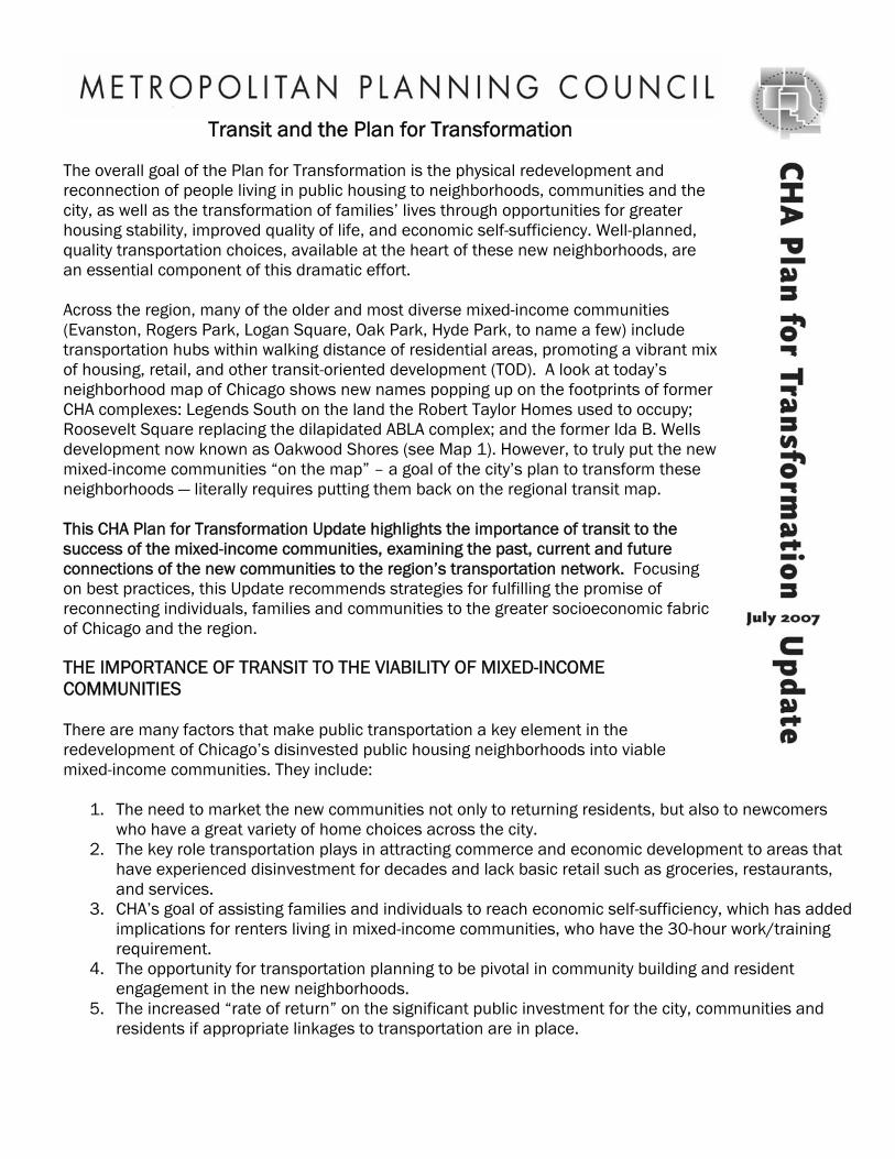
Transit and the Plan for Transformation The overall goal of the Plan for Transformation is the physical redevelopment and reconnection of people living in public housing to neighborhoods, communities and the city, as well as the transformation of families’ lives through opportunities for greater housing stability, improved quality of life, and economic self-sufficiency. Well-planned, quality transportation choices, available at the heart of these new neighborhoods, are an essential component of this dramatic effort. Across the region, many of the older and most diverse mixed-income communities (Evanston, Rogers Park, Logan Square, Oak Park, Hyde Park, to name a few) include transportation hubs within walking distance of residential areas, promoting a vibrant mof housing, retail, and other transit-oriented development (TOD). A look at today’s neighborhood map of Chicago shows new names popping up on the footprints of former CHA complexes: Legends South on the land the Robert Taylor Homes used to occupy; Roosevelt Square replacing the dilapidated ABLA complex; and the former Ida B. Wells development now known as Oakwood Shores (see Map 1). However, to truly put the new mixed-income communities “on the map” – a goal of the city’s plan to transform these neighborhoods — literally requires putting them back on the regional transit map. This CHA Plan for Transformation Update highlights the importance of transit to the success of the mixed-income communities, examining the past, current and future connections of the new communities to the region’s transportation network. Focusing on best practices, this Update recommends strategies for fulfilling the promise of reconnecting individuals, families and communities to the greater socioeconomic fabric of Chicago and the region. THE IMPORTANCE OF TRANSIT TO THE VIABILITY OF MIXED-INCOME COMMUNITIES There are many factors that make public transportation a key element in the redevelopment of Chicago’s disinvested public housing neighborhoods into viable mixed-income communities. They include:
1. The need to market the new communities not only to returning residents, but also to newcomers who have a great variety of home choices across the city.
2. The key role transportation plays in attracting commerce and economic development to areas that have experienced disinvestment for decades and lack basic retail such as groceries, restaurants, and services.
3. CHA’s goal of assisting families and individuals to reach economic self-sufficiency, which has added implications for renters living in mixed-income communities, who have the 30-hour work/training requirement.
4. The opportunity for transportation planning to be pivotal in community building and resident engagement in the new neighborhoods.
5. The increased “rate of return” on the significant public investment for the city, communities and residents if appropriate linkages to transportation are in place.

CHA Plan for Transformation Update ● July 2007 Page 2 The following recommendations address each of these factors.
1. Marketing the New Communities
A 2004 market assessment by Reconnecting America showed that at least a quarter of all U.S. households who will be looking for homes in the next 20 years – 14.6 million in total — will be looking to rent or buy within a half mile of fixed-guideway transit stops.1 AARP (formerly the American Association of Retired Persons) reports that 71 percent of older households want to live within walking distance of a train or bus.2
For former CHA residents returning to the new neighborhoods and newcomers thinking about moving to the new affordable and market-rate homes in these communities, access to transportation is a primary decision factor. According to Bill Goldsmith of the Community Builders Inc., a developer of the new Oakwood Shores mixed-income community, “A variety of transportation options is key to attracting former CHA residents to Oakwood Shores but also in marketing the community to newcomers.” As these new neighborhoods compete with other areas to attract a healthy mix of residents, transportation options become a must for marketing communities that have long endured isolation. Interestingly, market segments particularly interested in TOD solutions, including empty-nesters, singles, couples without children, and people without cars, are the main groups moving into the mixed-income communities developed as part of the Plan for Transformation - reinforcing the need to think about these neighborhoods as natural places for TOD.
“A variety of transportation options is key to attracting former CHA residents to Oakwood Shores but also in marketing the community to newcomers.” – Bill Goldsmith, The Community Builders Inc.
As more “product” at similar prices is developed in the vicinity of the former CHA sites and other neighborhoods across the city, strategic location of bus routes and train stations enhance the attractiveness and competitive edge of the mixed-income communities.
2. Supporting Retail and Commerce
For local businesses trying to establish themselves and larger retailers moving into the mixed-income communities, foot traffic means prosperity. An active, well-maintained transportation hub can anchor the economic development of neighborhoods that, for decades, have lacked the bare minimum of retail opportunities. With the delivery of the first batches of homes in mixed-income communities across the city, and thousands more in the queue, these neighborhoods are ripe for development of new retail corridors to become true destinations for shopping, entertainment and recreation. For instance, recent studies of the Quad Communities area (which includes the Douglas, Grand Boulevard, Kenwood and Oakland neighborhoods, as well as over one-third of the mixed-income homes developed through the Plan) showed that the Cottage Grove corridor has a $675 million purchasing power and would be able to absorb up to 700,000 sq. ft of commercial space.3 The entire area is expecting 10,000 new residents moving in within the next five years, most of them moving into mixed-income communities. Organizing all this growth along well-planned and well-served transportation corridors is vital to guarantee the success of these neighborhoods.

CHA Plan for Transformation Update ● July 2007 Page 3
3. Promoting Resident Self-Sufficiency To create a more viable culture than what existed in the previous era of failed public housing, CHA has made resident self-sufficiency a core objective of the Plan for Transformation. For instance, the property-specific requirements or “site-specific criteria” in the new communities, which in many cases include a 30-hour work requirement, reflects the fact that families must have a secure source of income to pay for housing and be economically stable.4 While the hope is to set high standards for residents in these high quality homes and make sure they are contributing to the community’s sustainability, it is challenging to enforce this requirement. Furthermore, it will be near impossible for residents to meet this work requirement if their communities are not linked to city and regional job centers through the reliable, affordable and versatile options that only public transportation can provide. For public housing residents and working families moving into the new mixed-income communities, easy access to their jobs, schools and training opportunities is absolutely essential to work towards economic self-sufficiency and meet the 30-hour work requirement. Many lower income families lack access to a car and depend on public transportation to go to their workplaces, whether located in Chicago’s Loop, surrounding neighborhoods, or suburbs. As Linda Kaiser, CHA manager of resident services, puts it: "Reliable public transportation is essential for connecting residents in CHA units to employers and jobs. Even the best training programs and placements are only effective if residents can arrive to work on time and in an affordable way." Reliable and affordable public transportation also relates to a family’s ability to save money. A recent study showed that while transportation costs consume around 8 percent of the household budget for the higher-income Chicago-area families, very-low-income families spend 53 percent or more of their budgets on transportation.5
"Reliable public transportation is essential for connecting residents in CHA units to employers and jobs. Even the best training programs and placements are only effective if residents can arrive to work on time and in an affordable way." - Linda Kaiser, CHA managing director of resident services
4. Building Community
Planning for transportation access and service can be a valuable and constructive tool for promoting resident engagement. Studies show that careful transportation planning can increase community cohesion in neighborhoods by promoting walkability, contributing to affordability, and making streets and transit stops pleasant places for neighbors to interact.6 Moreover, a recent New York study showed that, in areas with heavy car traffic, residents spend less time walking, shopping and playing with children in their neighborhood.7 A participatory planning process can bring together long-time residents and newcomers, local businesses and institutions, and policymakers, investors and champions, to decide what the community needs in terms of transit and transportation enhancements, as well as how to obtain it. Such a process can complement the investment of time, money and staff by CHA, foundations, and development teams to make sure the new residents of these communities have places and activities to interact with each other, the developments are well integrated within the fabric of the larger communities, and are well “wired” to schools, churches, community-based organizations, and other institutions.8 Also, a participatory process can ensure that this “re-connection” responds to

CHA Plan for Transformation Update ● July 2007 Page 4
the community demands, reflects the ability of the market to absorb new TOD, and engages the key players able to make recommendations happen.
5. Maximizing Public Investment and Existing Infrastructure
Millions of public dollars have been invested in the mixed-income communities from their initial stages, and will continue to be until final delivery of all of the homes, and throughout the life of the development. Public funds cover almost completely the high costs of demolition, land clearing, environmental remediation, and infrastructure. Government monies also comprise several layers of affordable housing financing in the form of tax credits, TIF dollars, HOPE VI funds, and other sources. Once the buildings are up and running, services for public housing residents and community-building activities are covered, again, by a patchwork of city, state and federal funding sources, plus philanthropic contributions. Although the Plan is usually referred to as a “$1.6 billion” effort, this figure is likely to grow as the redevelopment extends and development costs increase. In the Oakland community, where Jazz on the Boulevard, Lake Park Crescent and Oakwood Shores are being developed, more than $400 million in public investment is anticipated for infrastructure, housing, and social services related to mixed-income communities. And the investment will continue: in late 2006, to complement the $20+ million Service Connector program funded by CHA and managed by the Chicago Dept. of Human Services,9 U.S. Dept. of Housing and Urban Development, state, Chicago Mayor’s Office of Workforce Development and the local philanthropic partner, The Partnership for New Communities, came together to offer $23 million to connect public housing residents to jobs and workforce development programs.10 Again, a safe, fast and affordable commute to the workplace or training facility can make a critical difference for a household benefiting from these programs. To maximize the good use of the Plan’s public monies and leverage private investment, solid investments need to be made in local transit service. In many areas, these investments can take advantage of the basic infrastructure that already exists in the form of bus routes or rapid transit rail tracks. For example, plans for a TOD near Park Boulevard (on the footprint of the former Stateway Gardens) crystallized with the commitment to open a much-needed Metra station at 35th Street, near the Illinois Institute of Technology. This stop, when open in 2008, will complement the newly rebuilt Red and Green line CTA stops, affording residents access to jobs throughout the city and the South and Southwest suburbs. Conversely, Westhaven Park, being built along a 12-block stretch of the CTA Green Line, does not have a single stop. And, Metra lines run near the lake, along the eastern boundary of Oakwood Shores and Lake Park Crescent (roughly between 35th and 42nd streets), yet no stops are available between 27th and 47th streets.
RECONNECTING NEIGHBORHOODS In the past, many of the neighborhoods with new mixed-income sites and other public housing developments were better connected to the city’s transit system. Numerous CTA train stations along the current Lake Street Green Line corridor, specifically between Ashland and California, served the area where Westhaven Park (formerly Henry Horner) is located. These stations were closed by 1960 in order to streamline multiple transit options within a one-mile corridor and based on low population densities and weak ridership markets.11 Moreover, CTA discontinued Lake Street bus service in 1997, allegedly because of low ridership and duplication of Green Line service.12

CHA Plan for Transformation Update ● July 2007 Page 5 Many local stops serving the Cabrini-Green area, on the north side Brown Line, were closed due to spacing and poor ridership when the Ravenswood Line was instituted in 1949. The Kenwood branch of the CTA train, which ran from Indiana Avenue to 42nd Place across the current Oakwood Shores community, was abandoned in the late 1950s.13 Metra lines serving the MidSouth and lakefront areas, which encompass Oakwood Shores (formerly Madden Wells), Jazz on the Boulevard, and Lake Park Crescent, previously had stations at 39th and 43rd streets. These stations were taken out of service in the 1960s.14 Several stations along what is now the CTA Green Line were also closed in August 1949, between Roosevelt Road and 35th Street, effectively isolating CHA’s Hilliard, Ickes and Dearborn Homes communities.15 These reductions in public transportation options, along with the spread in the 1950s and 1960s of a planning paradigm that favored car-oriented development, segregation of uses, and large-scale enclosed public housing communities (through urban renewal projects and Euclidean zoning16), further isolated residents -- most of them African-American families of moderate to low-incomes -- and disconnected them from the socioeconomic fabric of the city. It is no wonder that in the early 1990s, when the federal government decided to tackle the decline of public housing across the nation, it embedded New Urbanism principles (TOD, mixed-uses, human-scale development) in redevelopment programs such as HOPE VI, which lead to the birth of the Plan for Transformation.
Looking to the future: Reconnecting Neighborhoods Led by the City of Chicago, Reconnecting Neighborhoods is a community planning initiative studying the transportation conditions in three former Chicago Housing Authority (CHA) sites - (Cabrini-Green, Henry Horner, and Madden/Wells/Lakefront - that are undergoing transformation into mixed-income communities (see Map 1). The project will identify opportunities for improvements in the transit system, as well as for transit-oriented development, with a focus on commercial and retail development. It is expected that, by the end of the project, a set of recommendations will be developed and that momentum for implementation will be underway, thanks in part to the support of stakeholders, investors and champions. The new Plan for Transformation communities include a mix of public housing residents, families paying affordable prices and rents for their homes, and market-rate buyers and renters. It is expected that Reconnecting Neighborhoods will foster interaction between new and long-time stakeholders in these communities, creating a place for much-needed constructive community-building. The role of MPC in this community building effort includes:
• Ensuring an ongoing, inclusive, and well-informed process of stakeholder participation to guide the studies produced as part of the project.
• Attracting the interest of public, private and nonprofit champions and investors to the opportunities in these communities.
• Assembling and engaging a panel of independent experts who would inform the recommendations arising from the studies.
• Bringing the best practice thinking from other regions in the world to bear in Chicago For more information, please call MPC’s new Project Manager for Reconnecting Neighborhoods, Brandon Johnson, at 312-863-6046.

CHA Plan for Transformation Update ● July 2007 Page 6 Map 1: Reconnecting Neighborhoods in Context
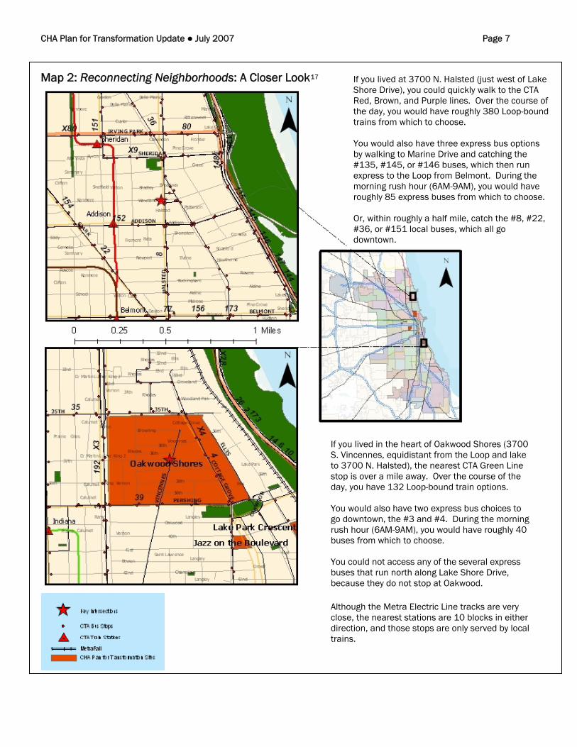
CHA Plan for Transformation Update ● July 2007 Page 7 Map 2: Reconnecting Neighborhoods: A Closer Look17
If you lived at 3700 N. Halsted (just west of Lake Shore Drive), you could quickly walk to the CTA Red, Brown, and Purple lines. Over the course of the day, you would have roughly 380 Loop-bound trains from which to choose. You would also have three express bus options by walking to Marine Drive and catching the #135, #145, or #146 buses, which then run express to the Loop from Belmont. During the morning rush hour (6AM-9AM), you would have roughly 85 express buses from which to choose. Or, within roughly a half mile, catch the #8, #22, #36, or #151 local buses, which all go downtown.
If you lived in the heart of Oakwood Shores (3700 S. Vincennes, equidistant from the Loop and lake to 3700 N. Halsted), the nearest CTA Green Line stop is over a mile away. Over the course of the day, you have 132 Loop-bound train options. You would also have two express bus choices to go downtown, the #3 and #4. During the morning rush hour (6AM-9AM), you would have roughly 40 buses from which to choose. You could not access any of the several express buses that run north along Lake Shore Drive, because they do not stop at Oakwood. Although the Metra Electric Line tracks are very close, the nearest stations are 10 blocks in either direction, and those stops are only served by local trains.

CHA Plan for Transformation Update ● July 2007 Page 8 Since the inception of the Plan in 2000, more than 14,000 homes have been built and rehabbed in areas formerly occupied by dilapidated public housing high-rises, approximately 5,300 in mixed-income communities.18 These new homes are attracting a healthy mix of residents back to communities that have hemorrhaged population for decades. With more rooftops and a healthy appetite for buying and leasing them, come more residents and increased demand for retail and transportation. All of the mixed-income sites are seeing improvements already -- as their former “urban renewal-style” street network is substituted by a street grid similar to that found across the city -- connecting developments to thoroughfares and corridors, and linking a variety of housing, commercial and recreational uses -- making streets real “places” for shopping, playing, or just sitting and enjoying neighborhood life. New bus stops are being established in the vicinity of these developments and, as mentioned above, Metra stations are being planned for places like Park Boulevard (near IIT); however, there is an enormous amount of untapped potential for improvement.
0
100
200
300
400
500
600
Tra ns i t Opt io ns w ith in 1 M i le Ra d ius (a ppro x .)
3700 North Halsted 380 220 578
3700 South Vincennes 132 40 250
Daily Loop-Bound
Trains
Daily Loop-Bound
Express Buses
Daily Loop-Bound
Local Buses
Population within 1 Mile Radius (approx.)
2000 2006
(estimated) 2011
(projected) 3700 North
Halsted 89,298 87,218 85,713 3700 South Vincennes 36,952 38,198 48,541
Organizations such as Quad Communities Development Corporation (QCDC) have already started a conversation around transportation that focuses on filling service gaps. In 2004, the community identified access to child care, frequency of service, and cost and long-distance commutes to suburban job centers as the main challenges related to transportation. The group has successfully advocated for an evening-shift shuttle van service, funded by the Mayor’s Office of Workforce Development through the Job Access Reverse Commute program (created in the wake of welfare reform to help former welfare recipients address transportation obstacles). Still, Chicago needs a more comprehensive approach to transportation in mixed-income neighborhoods. As stated by Bernita Johnson-Gabriel, QCDC executive director, "We have developed private and public partnerships to tackle the void of retail/commercial development in our community. It's only natural to follow that same path in addressing the lack of viable transportation options for residents and stakeholders alike.” Map 2 and the charts above show a closer look at transit in the Oakland community in comparison with Lakeview (a community equidistant to the Loop and the lake).19

CHA Plan for Transformation Update ● July 2007 Page 9 POLICY RECOMMENDATIONS FOR IMPROVING TRANSPORTATION ACCESS IN MIXED-INCOME COMMUNITIES
1. Push for federal, state, and regional commitments to invest in public transportation in the areas affected by the Plan for Transformation.
Major changes in public transportation networks require federal and state funding and support. As vital as creating partnerships with community organizations and leaders is, involving state and federal legislators early in the planning of community transportation enhancements is critical. The need for an efficient system to prioritize projects is also important. MPC believes funding for transportation capital projects in our region should be chosen through an accountable and transparent prioritization system and is working with the evolving Chicago Metropolitan Agency for Planning to create a solution for the region. MPC strongly supports the efforts of the Regional Transportation Authority (RTA) to adequately fund and maintain our regional transit system and endorses a reinvention of the RTA’s planning powers and additional investment of transit funds for our region. This will ensure capital and operating needs (including those needed to support transportation improvements in mixed-income communities) are met equitably.
2. Make collaborative and participatory transportation planning a
key component in the redevelopment of public housing into mixed-income housing through processes that include all stakeholders and coordinate different levels of government.
As Reconnecting Neighborhoods illustrates, creation and implementation of successful transportation plan requires the engagement of many relevant stakeholders, from residents to local businesses to neighborhood institutions. Groups need to be educated on basic concepts of transportation planning and guaranteed a “voice” in the development of plans. They can also be instrumental in gathering support for the plan’s recommendations from policymakers, investors and funders. Many can become “champions,” who make the recommendations happen.
"We have developed private and public partnerships to tackle the void of retail/commercial development in our community. It's only natural to follow that same path in addressing the lack of viable transportation options for residents and stakeholders alike.” – Bernita Johnson-Gabriel, QCDC executive director
Such efforts also require close collaboration between federal, state, regional, and city levels of government, including all Departments of Transportation, other relevant city agencies (Planning and Development), transit providers, and regional agencies such as the RTA and the Chicago Metropolitan Agency for Planning to help guide the process.
3. Connect transportation planning around the Plan for Transformation to other citywide initiatives
such as the Olympics and “greening” of Chicago, ensuring they reinforce each other.
Lori Healey, then commissioner of the Chicago Dept. of Planning and Development and now Mayor Richard M. Daley’s chief of staff, recently described the huge impact the Plan for Transformation had on the U.S. Olympic Committee (USOC), as it toured Chicago and evaluated it against Los Angeles as potential host of the 2016 Games. Indeed, several mixed-income communities are located in the vicinity of proposed Olympic venues (Westhaven Park is walking distance to United Center, and Legends South will be a few blocks to the proposed Olympic Stadium at Washington

CHA Plan for Transformation Update ● July 2007 Page 10
Park). Public transportation enhancements, a key decision factor for the International Olympic Committee, must be coordinated with improvements in CHA mixed-income communities. Also, as Chicago keeps striving to be a symbol of urban sustainability, transit within mixed-income communities (an effective tool to manage traffic congestion and pollution, as well as global warming) should be included as a core city strategy to make Chicago a greener place to live. LEED (Leadership in Energy and Environmental Design) standards are emerging for neighborhood development (known as LEED-ND), creating an excellent opportunity to increase the sustainability and marketability of the mixed-income communities and make them models of “green development.”
4. Incorporate transportation planning into redevelopment plans for “traditional” public housing sites
and communities in the mixed-income development “pipeline.”
Although this update focuses on new mixed-income communities, there are more than 5,000 homes being rehabilitated in 100 percent public housing communities across the city. Several of these communities are located in isolated areas of Chicago’s Far South Side. The largest, Altgeld Gardens/Phillip Murray Homes (around 2,000 apartments located between 130th and 133rd streets between Indiana Avenue and I-94) are currently served by just two CTA buses and in dire need of better transit access. Other communities have recently been slated for mixed-income development and can benefit from incorporating TOD elements into their early master planning processes. They include LeClaire Courts in the vicinity of Midway Airport and Lathrop Homes located east of the Logan Square community, on the bank of the Chicago river.
CONCLUSION Reconnecting the new mixed-income neighborhoods created by the Plan for Transformation to the socioeconomic fabric of our region requires putting into action the principles of equity of opportunity, economic competitiveness, and sensible growth that are keystones of MPC’s mission. The heart of any world-class metropolitan region is accessible and vibrant neighborhoods that are well-served by transit. Putting Chicago’s growing mixed-income neighborhoods back onto the transit network map entails a commitment to equity that will reinforce the need for solid support from public, private and nonprofit partners to the success of the Plan, and to our region. Through the Reconnecting Neighborhoods initiative, those partners, along with community residents, now have a place to gather, collaborate and make transportation enhancements happen.

CHA Plan for Transformation Update ● July 2007 Page 11
Endnotes
1 Reconnecting America’s Center for Transit-Oriented Development (2004), Hidden in Plain Sight: Capturing the Demand for Housing Near Transit. Available online at: www.reconnectingamerica.org/public/download/hipsi2 See “Reconnecting America…” cited above. 3 Quad Communities Development Corporation, Cottage Grove Shows Retail Potential. Available online at: www.qcdc.org. 4 For more on this requirement, see MPC CHA Plan for Transformation Update: July 2005. 5 Center for Neighborhood Technology and Virginia Tech (2006), Housing & Transportation Cost Trade-offs and Burdens of Working Households in 28 Metros. Available online at: www.cnt.org/repository/H-T-Tradeoffs-for-Working-Families-n-28-Metros-FULL.pdf. 6 Victoria Transport Policy Institute (2006), Community Cohesion as a Transport Planning Objective. Available online at: www.vtpi.org/cohesion.pdf7 Transportation Alternatives (2006), Traffic’s Human Toll. Available online at: http://www.transalt.org/campaigns/reclaiming/trafficshumantoll.pdf. 8 MPC CHA Plan For Transformation Update August 2006 9 MPC (Nov. 2004), CHA boosts funding for Service Connector Program up to $20.5 million in 2005.Available online at: www.metroplanning.org 10 MPC CHA Plan For Transformation Update December 2006 11 More on the Lake Street Green Line history at www.Chicago-L.org. 12 More on West Side transit history available at: www.bettertransit.com; “Bring back the Lake street bus,” Chicago Sun-Times, January 12, 2003. 13 More on the Ravenswood Line and Kenwood Branch at www.Chicago-L.org. 14 Research by Draper and Kramer, Inc. (2005) 15 More on the Jackson Park Green Line history at www.Chicago-L.org. 16 Zoning based on the segregation of land uses into specific districts, namely residential, commercial, industrial or institutional. Uses within each district are usually heavily prescribed to exclude other types of uses. 17 Transit information from CTA; geographic data from CTA, City of Chicago, ESRI and IDNR 18 CHA FY2007 Moving to Work Annual Plan – Plan for Transformation Year 8. Available online at: www.thecha.org/transformplan/plans.html, and MPC. 19 Population projections in charts from CHA and SRC, LLC. Transit information from CTA.

CHA Plan for Transformation Update ● July 2007 Page 12
For a more comprehensive analysis of CHA’s historic Plan for Transformation, visit MPC’s website at www.metroplanning.org. MPC Fact Sheets, Updates, and other research
papers that examine various components of the Plan are available.
This Update was prepared by members of the Metropolitan Planning Council’s Housing Team, Robin Snyderman, housing director; Roberto Requejo, housing associate;
and Laura Broussard, housing research assistant. Josh Ellis, community development associate, also contributed to this Update.
MPC is deeply grateful to the following funders who made this report possible:
The John D. and Catherine T. MacArthur Foundation
Bowman C. Lingle Trust Fannie Mae Foundation F. B Heron Foundation
Harris Family Foundation McCormick Tribune Foundation