translation of otto zdansky’s the localities of the
TRANSCRIPT

Palaeontologia Electronica http://palaeo-electronica.org
Jokela Tuomas, Eronen Jussi T., Kaakinen, Anu, Liping, Liu, Passey, Benjamin H., Zhaoqun, Zhang, and Mingkai, Fu. 2005. Translation of Otto Zdansky’s “The Localities of the Hipparion Fauna of Baode County in Northwest Shanxi” (1923), Palaeontologia Electronica Vol. 8, Issue 1; 3A:10p, 1.8MB; http://palaeo-electronica.org/paleo/2005_1/jokela3/issue1_05.htm
TRANSLATION OF OTTO ZDANSKY’S“THE LOCALITIES OF THE HIPPARION FAUNA OFBAODE COUNTY IN NORTHWEST SHANXI” (1923)
Tuomas Jokela, Jussi T. Eronen, Anu Kaakinen, Liu Liping, Benjamin H. Passey, Zhang Zhaoqun, and Fu Mingkai
ABSTRACT
In honor of Will Downs and his example of making original research papers avail-able to the scientific community, we present a translation of the classic study of theBaode area of Shanxi Province, China, written by Otto Zdansky in 1923. The transla-tion preserves the idiosyncratic spelling and technical language of the original, in part aproduct of the times.
Tuomas Jokela. Department of Geology, University of Helsinki, P.O. Box 64, FIN-00014 University of Helsinki, Finland. [email protected] T. Eronen. Department of Geology, University of Helsinki, P.O. Box 64, FIN-00014 University of Helsinki, Finland. [email protected] Kaakinen. Department of Geology, University of Helsinki, P.O. Box 64, FIN-00014 University of Helsinki, Finland. [email protected] Liping. Institute of Vertebrate Paleontology and Paleoanthropology, Chinese Academy of Sciences, Xi-Zhi-Men-Wai Street, No.142, Beijing, China. [email protected] H. Passey. Department of Geology and Geophysics, University of Utah, 135 S. 1460 E., Salt Lake City, Utah 84112, USA. [email protected] Zhaoqun. Institute of Vertebrate Paleontology and Paleoanthropology, Chinese Academy of Sciences, Xi-Zhi-Men-Wai Street, No.142, Beijing, China. [email protected] Mingkai. Department of Geology, University of Helsinki, P.O. Box 64, FIN-00014 University of Helsinki, Finland. (Fu Mingkai is otherwise known as Mikael Fortelius) [email protected]
KEY WORDS: Hipparion Red Clay, China, Miocene, vertebrate fossils
PE Article Number: 8.1.3ACopyright: Society of Vertebrate Paleontology May 2005Submission: 12 November 2004. Acceptance: 13 April 2005

JOKELA ET AL.: TRANSLATION OF ZDANSKY’S 1923 HIPPARION FAUNA OF SHANXI
2
INTRODUCTION
Otto Zdansky’s classic 1923 paper “Fundorteder Hipparion-Fauna um Pao-Te-Hsien in NW-Shansi” (Bulletin of the Geological Survey, China,Volume 5, pp. 69-82) remains the only detaileddescription of the localities that have deliveredmuch of the finest Chinese mammalian fossil mate-rial stored in museums in and outside China. Inparticular, the majority of the Chinese large-mam-mal fossils in the Lagrelius Collection in theMuseum of Evolution in Uppsala, Sweden, and inthe Frick Collection in the American Museum inNew York, were collected in the Dragon BoneMines of Jijiagou and adjacent gullies in BaodeCounty, Shanxi Province. The mines were mappedand described by Zdansky during a prolonged stayin the area, in order to supervise the collecting andshipping of material destined for Uppsala.
The late Neogene Red Clay deposits (previ-ously also known as Hipparion Clay) are wide-spread in north China covering an area similar tothe overlying Pleistocene loess deposits. In recentyears, research has demonstrated an eolian originfor the Red Clay, as for the overlying Pleistoceneand Holocene loess.
During a field season in the Baode area inSeptember 2004, we decided to translate Zdan-sky’s German text for the benefit of team membersunfamiliar with that language. It subsequentlyoccurred to us that we ought to make the transla-tion available to the scientific community at large,in the admirable spirit of Will Downs, whose manytranslations of Chinese publications into Englishare such a rare treasure for all international collab-orations involving Cenozoic vertebrate fossils fromChina. We are happy to dedicate our translation to
the sweet remembrance of our late friend and col-league “Mr. Dong” (Dong Weilin was Will’s Chinesename.).
It should be emphasized that this translation isthe work of happy amateurs, and although we havetaken reasonable precautions to avoid mistakes,inaccuracies may well remain. The use of italicsfollows the original. We have used the establishedterm “Hipparion Clay,” although the correct transla-tion of Zdansky’s term “Lehm” would be loam, abetter match for the lithology in question. Zdanskyrepeatedly used variants of the expression “dieLagerung is schwebend.” This seems at first tosuggest that he thought that the stratification wasweak or vague (“floating”), but apparently “schwe-bend” in this context is actually an old miner’s termmeaning simply horizontal. The transcription ofplace names given by Zdansky is unchanged, withthe modern pinyin equivalent given in brackets atthe name’s first occurrence in the text. The lack ofcitations and references is genuine.
Zdansky supplied a wonderfully detailed mapof Baode County area (Pao Te Hsien), which wedesignate as our Figure 1. The labelling of illustra-tions and tables originally used by Zdansky wasrevised for convenience and compatibility withonline viewing. In the original, there were four textdrawings labelled as figures. In addition, therewere five plates or “tables” at the end of the article,labelled with Roman numerals, of which tables Iand II both comprised two photographs, then calledFigure 1 and Figure 2, respectively. Tables III andIV were maps of the fossil mines. Herein, the fig-ures and tables are referred to as successive fig-ures with Arabic numerals, in the order in whichthey are discussed. The translation follows below.
HIPPARION-FAUNA FOSSIL LOCALITIESIN PAO-TE-SHIEN, NW-SHANSI
Otto Zdansky
Uppsala University, Sweden
TOPOGRAPHY
In northwestern Shansi, in the region of Pao-Te-Hsien [Baode county], is one of the centres ofthe trade of fossil bones in northern China. Pao-Te-
Hsien itself is located eight days travel northwestfrom the provincial capital Tai-Yuan-Fu [Taiyuancity], on the Yellow River. The area considered isnortheast of Pao-Te-Hsien and has its centre

JOKELA ET AL.: TRANSLATION OF ZDANSKY’S 1923 HIPPARION FAUNA OF SHANXI
3
approximately in Chi-Chia-Kou [Jijiagou], about 13km to the northeast of the town.
The land is a plateau rising towards the eastfrom the Yellow River on the west. It is, however,cut by ravines and gullies, giving the impression ofa hilly landscape, until a view from a greater dis-tance reveals the evenness of the overall rise.
The attached map shows the region’s topog-raphy and geology. As can be seen, almost all the
valleys reach the Carboniferous (base), in whichthe water has often carved canyons of 10-15 mdepth. Coal can be found almost everywhere, andit is quarried from several mines, however, mostlyfor domestic use. In general, the Carboniferous lieshorizontally, but locally the beds can also beslightly folded. At the boundary between the Car-boniferous and the overlying Hipparion Clay, smallsprings are often to be found.
Figure 1. Originally Tafel V. 1:20,000 map of the Baode area.

JOKELA ET AL.: TRANSLATION OF ZDANSKY’S 1923 HIPPARION FAUNA OF SHANXI
4
LU-TZU-KOU SERIES
In a very small area (which can be partiallyseen in the northwest corner of the map) above theCarboniferous unit, there are layers, the preciseage of which should be determinable after study ofthe collected fossils. For the time being, the nameLu-Tzu-Kou Series is proposed, according to themain locality. The geographical extent of thesesediments is restricted to the valley where the vil-lage of Chung-Lu-Tzu-Kou [Zhongluzigou] islocated, with its side valleys and the northern paral-lel valley. These sediments cannot be found eitherin the north, south, or east, but during a trip to Nan-Sha-Wa [Nanshawa] the author saw (about 30 kmnorth of Chi-Chia-Kou) a 30-cm thick bed of quartzcobbles between the Carboniferous unit and theHipparion Clay. This probably is part of the Lu-Tzu-Kou Series. Westward these extend as far as theYellow River.
At Chung-Lu-Tzu-Kou [Zhongluzigou], thestrata occasionally reach a maximum thickness of25 to 30 m, although in the closest proximity, sedi-ments of lesser thickness can also be found. Theseries begins above the Carboniferous unit with alayer of quartz shingle (a piece of jadeite was alsofound in it). The spaces between the clasts arefilled with yellow and green quartz sand. Here andthere, where the cementing is stronger, a massivebed of conglomerate occurs. Lenses of fine sandand fragments of green marl with fish remainsoccur as inclusions. These gravel layers includemoderately rounded bone fragments and teeth oflarger mammals. Among the finds were isolatedteeth of an equid, a rhinocerid, and a rodent. Over-lying the gravel follows the green-yellow marl andcarbonaceous marl with freshwater molluscs andimpressions of plants. Overlying these are cross-bedded fine yellow sands. A rhinoceros mandiblewas found in these. An important horizon consistsof greenish-white, stratified, calcareous marl,
which in places is quite filled with fish remains.Additionally, a smaller amount of molluscs can befound, although in many places in the same hori-zon, this can be quite the reverse (i.e., more mol-luscs than fish). Thus far, it can be stated that themolluscs are represented by two species of gastro-pods and lamellibranchiates each.
The most complete profile for describing thedifferent components, although not the thickest, isdescribed as follows. It comes from the easternface of [the ravine]
Sang-T’a-Kou [Sangdagou], which opens inthe main valley southeast of Chung-Lu-Tzu-Kou[Zhongluzigou]. It can be seen in Figures 2 and 3.
VI. More than 4 m of reddish, loess-like mate-rial with bone splinters and tooth fragments of rhi-noceros in a layer with calcium carbonateconcretions at the base.
V. 1.3 m of greenish-white, stratified, calcare-ous marl with plenty of bone splinters of largermammals and molluscs.
IV. 4.5 m of fine yellow sands with crossbed-ding. Mandible of Rhinoceros.
III. 2.3 m of green-yellow marls and calcare-ous marls with fish fossils and molluscs.
II. 6.5 m of quartz cobbles, the interstices filledwith yellow and green sands. In places iron-stainedand hardened. Contains lenses of green sand andblocks of marl. Includes rounded bone fragmentsand teeth of mammals.
I. CARBONIFEROUS.
The red sediment that caps this sequencecannot, as so often happens, be distinguishedeither from loess or from Hipparion Clay with cer-tainty. Because of this, this profile does not give asatisfactory answer to the question of the relation-ship of the Lu-Tzu-Kou series to the HipparionClay, but the problem is solved through a profile ofCh’I-Tzu-Kou [Qizigou], which is a parallel valley of
Figure 2. Originally Figure 1. Schematic profile of the Lu-Tzu-Kou layers at Sang T’a Kou [Sangdagou].

JOKELA ET AL.: TRANSLATION OF ZDANSKY’S 1923 HIPPARION FAUNA OF SHANXI
5
Lu-Tzu-Kou [Luzigou]. The latter can be seen inFigure 4. The abandoned cave dwellings, the twoentrances of which can be seen, are still situated inthe deposits concerned. In this particular place,these deposits form a harder carbonate bank thatis rich with fish fossils. But overlying this, with asharp contact, is the Hipparion Clay, recognised assuch not only by its clearly distinguishable petro-graphic nature, but also through its fossil content.
In Lun-Ch’üh-Kou [Lunqugou?] (visible onmap), a layer of greenish carbonate marl, rich ingastropods and with some fish fossils, appears in ared clay, that appears extremely similar to the Hip-parion Clay. Until the fossil material is studied, pre-liminary survey and geological considerationssuggest a Miocene age for the Lu-Tzu-Kou series.The stratification is horizontal.
HIPPARION CLAY
The above mentioned deposits are, however,absent from most of the area studied. The Carbon-iferous is covered by the Hipparion Clay, some-times directly. Most often, however, there is aconglomerate bed of varying thickness (sometimesup to 4 m thick). The cobbles and the matrix are of
calcium carbonate. The stratification is horizontal.Nonetheless, the conglomerate formed before theHipparion Clay. Fossils cannot be found in it. Topo-graphically the conglomerate can be recognisedbecause it forms a layer between the highest slate-like members of the Carboniferous unit and the redclay. Being harder than either of these, it forms afrequently undercut projecting cliff in the ravines. Itis noteworthy that its calcareous matrix is grey,while the carbonate layers in the Hipparion Clayare cemented by the red clay.
Above this lies the Hipparion Clay, red claysimilar to that of Pikermi in every respect. Themaximal observed thickness is about 65 m. A sub-division into different horizons cannot a priori becarried out because the commonly occurring shin-gle beds are not sufficiently continuous. However,they demonstrate that a horizontal stratification ispresent. Layers of carbonate concretions occursparsely. A fossil-rich horizon appears in this clayabout 1150 m (cf. the map). It is mined by the localpopulation. The fossils of the fauna characterizedby Hipparion Richthofeni Schl. appear in “nests,” inwhich usually a great number of bones of the mostdifferent forms occur together in a restricted space,typically from 0.5 to 2.0 cubic meters in volume.
Figure 3. Originally Taf. I, Figs. 1, 2. Exposures of the LuTzu Kou lithology at Sangdagou.
Figure 4. Originally Taf. II, Figs. 1, 2. Lu Tzu Kou lithol-ogy at the local valley Qizigou.

JOKELA ET AL.: TRANSLATION OF ZDANSKY’S 1923 HIPPARION FAUNA OF SHANXI
6
Complete skeletons were not found, but more orless complete limb bones and parts of vertebralcolumns are present. Also, carnivore skulls appearwith their mandibles attached, and this is also thecase with the rhinocerids. These fossils are quiteheavily mineralised, the marrow cavities are usu-ally filled with crystals of calcite, and the surfaceappears pure white. The clay is infiltrated and hard-ened by calcite in the immediate vicinity of the fos-sil “nests.” At times small sand lenses areembedded in the clay. They usually contain smallfragments of bone. Often a certain stratification canalso be recognised within the fossil “nests.” In addi-tion to the shingle layer, the clay also contains iso-lated cobbles of small size.
As already mentioned, the fossil “nests” all layat one level, although there can be vertical varia-tion of about 5 m, and, indeed, two fossil nests maylay one directly above the other, separated by a 1m gap. Of the total thickness of Hipparion Clay, 25m thus lie under and 35 m above the fossil level(see Figure 5). As for the fossil content of the
nests, it is everywhere the same, i.e., no forms arelimited to certain localities only. However, it mustbe noted that especially locality 30 at Tai-Chia-Kou[Daijiagou] contains almost exclusively larger rumi-nants and carnivores, in addition to rhinocerids,which are common everywhere. In Yang-Mu-Kou[Yang-Mu-Gou], locality 49, a fossil nest unusuallyrich in carnivore fossils was found. On anotheroccasion, the remains of at least four pigs, whichare otherwise quite rare, were found together in thesmallest of spaces. The west-east extent of theregion is 5.5 km, and the north-south extent is 5.0km. The clay is covered by loess, which can reacha very considerable thickness. Once it covered thewhole region, but in the course of time, the post-Tertiary streams have carved themselves in, sothat the topography has by-and-large remainedunchanged (see profile A-B, Figure 5). In supportof this argument, it can be stated that in the sidevalleys, which are naturally younger, the contactbetween the Hipparion Clay and loess is alwaysparallel to the modern surface. Fossils are notknown from the loess in this region. Finally, the hill-tops are mostly covered with eolian sand, a circum-stance explained by the proximity of the OrdosDesert.
FORMATION OF FOSSIL NESTS
The question of the formation processes ofthe fossil nests in the Hipparion Clay is difficult toanswer. It is to be kept in mind that the localities liein one horizon, where differences in the level ofnests can be up to 5 m. This indicates that at thetime of deposition, the surface in the region wasalmost horizontal. That the process of depositionwas affected by running water can be seen fromthe way the fossil nests are situated, separated byunfossiliferous spaces in-between, with the occur-rence of small sand lenses as well as levels ofbone fragments. The preservation of the fossilsindicates they have not been transported over longdistances. And now the author must thank Dr. J.G.Andersson for making the author aware of hisobservations of how variable the flow of (tempo-rary) water channels is today in the Mongoliansteppe. It is thus quite possible, that in the region,which was almost flat at the time of deposition ofthe fossil beds, the conditions were similar, so thatin the course of years, maybe even during a singlerainy season, the fossils were transported togetherfrom nearby areas by the shifting water channels.Thus, all the nests cannot be strictly contempora-neous, which also explains the differences in levelalready mentioned, likewise the appearance of twonests above each other. Finally, as for the con-
Figure 5. Originally Fig. 2. Two observed sections illus-trating the general profile of the Hipparion fauna fossillevel.

JOKELA ET AL.: TRANSLATION OF ZDANSKY’S 1923 HIPPARION FAUNA OF SHANXI
7
strained distribution of the fossil occurrence to onlya fraction of the entire red clay deposit, also herethe author wants to refer to personal communica-tion with Dr. Andersson. According to Dr. Anders-son, some areas in the steppe at certain timescould, through a favourable combination of topo-graphic and climatic conditions, support an espe-cially lush vegetation, which naturally caused aconcentration of animals in these areas. In the sur-roundings of Chi-Chia-Kou, we would thus see theremains of such an oasis. The assumption of acatastrophe, as proposed for example by Prof. O.Abel for the Pikermi deposits, is not consideredlikely by the author, because of the absence offractures in the remains and the topography at thetime deposition. Neither can the reason for thedeposition be a larger watercourse. Although thiscould be argued in the case of locality 30, the irreg-ular distribution of the localities and the fact that insingle mines there are no continuous fossil layers,cannot be brought into harmony with such a view.
CHARACTERISTICS OF THE FAUNA
Hereby an attempt will be made to character-ise the fauna, as far as possible, before prepara-tion of the collections. Attention will also be paid tothe material collected earlier by Dr. Andersson’sChinese collectors. The perissodactyls are repre-sented by the already mentioned and quite com-mon Hipparion Richthofeni, Anchitherium, andrhinocerids, which are classified to six differentspecies according to a letter from Prof. Wiman.Four of them belong to the genus Teleoceras, oneto the genus Aceratherium, and finally the mostinteresting form to Sinotherium Lagrelii, Ringström.The rhinocerids, because of their size and abun-dance, are by far the most notable element of thefauna. The artiodactyls are well represented bothin the number of species and of individuals. Thereare cervicorns of various sizes; however, they arenot so common. A host of different antelopesoccurs in great quantities; one form of pellicornwas named Chilinotherium Tingii by Prof. Wiman.The bunodonts are represented by two species ofpigs, one being the same size as Sus erymanthiusof Pikermi, the other being considerably smaller.The number of carnivore species is quite signifi-cant. A gigantic hyena is the most common. Viver-rids are not uncommon. Felids are also found,including the rare Machairodus. There is also askull that belongs either to Hyaenarctos or Arcto-cyon. Of mustelids, there are at least two species,and finally a skull resembling that of a badgershould be mentioned. Elephants are represented
by Mastodon, Stegodon, and Elephas. Of rodentsthere are only two species: a beaver-like mandibleand a skull of the size of Sciurus.
Of bird fossils, only the pelvis of a struthionidis known. It is considerably larger than that of therecent African Ostrich.
Of reptiles there are at least two species oftortoises, one testudinid and one emydid.
FOSSIL EXCAVATION METHODS
The excavation of fossils for medical use con-stitutes a source of income for the people. It is hardto tell how long it has been practiced; one estimateis 60-70 years. However, when the large number ofabandoned mines and the length of some still inuse are taken into account, an older age of thepractice can be considered. The quarrying com-mences in such a way that where conditionsappear promising, for example at a site where fos-sils occur on the surface, a horizontal tunnel about90 cm wide and high is excavated. Where a largerfossil concentration is found, the tunnel can beenlarged into a chamber. If the nest, which at thebeginning of the activity was productive or in laterphases of the activity was recently being worked, isexhausted, excavation is continued arbitrarily inany direction, in which activity only the commonhardening of the clay in the vicinity of the fossilscan give an indication of the outcome of the cho-sen direction. There are no deviations from the hor-izontal level, if small exceptions are ignored.People often dig for four to five days or for oneweek until another fossil nest is found. This work-ing method explains the irregularities and branch-ing of the tunnels (see Figures 6, 7). The toolsused are generally simple (see Figure 8). A rela-tively heavy pickaxe with a short handle is the gen-eral tool used in the work. A small hatchet is usedfor separating the fossils from the matrix and theteeth from the jaws. For transportation of the mate-rial, a small wooden cart with four small wheels isused. It is 1.3 m long, 60 cm wide, and 35 cm high.A flat basket on the cart contains the excavatedmaterial. People especially trained for this task pullthe cart on all fours, using a harness that runsbetween the legs and over one shoulder. Oil lampstypical for the region and placed in specially carvedniches or standing on suitable iron rods driven intothe clay, are used for illumination. In spring, thebuyers for the Chinese drugstores come and buythe available stock. One catty of bones is worth 6cash [no units in original], and 1 catty of teeth isworth 6-8 copper cents. During the summer, miningactivities usually cease because of farming.

JOKELA ET AL.: TRANSLATION OF ZDANSKY’S 1923 HIPPARION FAUNA OF SHANXI
8
OTHER LOCALITIES
During his travels, the author also visited Nan-Sha-Wa in the region of Ho-Ch’ü-Hsien [HequCounty], 140 li [=70 km] north of Chi-Chia-Kou.There, also, the people excavate the fossils of theHipparion fauna. The fossil nests there seem to belarger, but less filled with bones. However, thenumber of the mines is too small (three, of whichonly two are being used) to allow any significantconclusions to be made. The matrix there is sand-ier, and the immediate proximity of the bones isseldom infiltrated by calcium carbonate. As in Chi-Chia-Kou, the tunnels are situated 25 m above theCarboniferous layer and are covered by about 30m of barren clay. See illustration [Figure 5]. Theyare 1 m high and up to 3 m wide. The reason forthis is partly explained by the softer matrix and
Figure 6. Originally Tafel III. The dashed line indicatesold tunnels that are not presently accessible. FF =Places where fossils could be seen at the time of obser-vation. Loc. 43: a.) Two layers with small bones, each 2cm thick, between which are others, irregularly dis-persed. Loc. 109: a.) Layers with bone fragments thesize of hemp seeds.
Figure 7. Originally Tafel IV. Symbols as in Figure 6. Loc.110. The tunnels lie immediately below a cobble layer.Loc. 44: a.) Lenses of sand and bone fragments 12 cmthick, b.) Lens of sand and bone fragments, c.-e.) Sandlenses.
Figure 8. Originally Fig. 3. Tools used in digging fossils.
JOKELA ET AL.: TRANSLATION OF ZDANSKY’S 1923 HIPPARION FAUNA OF SHANXI
9
partly by the sparser distribution of fossils. Thepickaxe used is wedge-shaped, with a short,straight edge. For transportation, a small wheelbar-row on a wooden wheel with a basket tied to it isused.
A further region that was visited during travelis Wu-Lan-Kou [Wulangou] in the region of Fu-Ku-Hsien [Fugu County] in Shensi, 110 li [=55 km]west of Pao-Te-Hsien. A host of tunnels is situatedthere, all in a very restricted space in a side ravine.The significance of the fact that they all lie at thesame height would not have been noted, had thisnot also been noticed in Chi-Chia-Kou. Also therethe material is sandy/clayey, and the bones in con-trast are more fragile than in Chi-Chia-Kou. Abovethe fossil horizon, there is about 35 m of barrenclay. The height above the Carboniferous could notbe established. Thus, it seems that the total thick-ness of the Hipparion clay is the same in all threeregions, and the position of the fossil horizon is thesame in each case. The working methods are thesame as those used in Chi-Chia-Kou.
SUMMARY
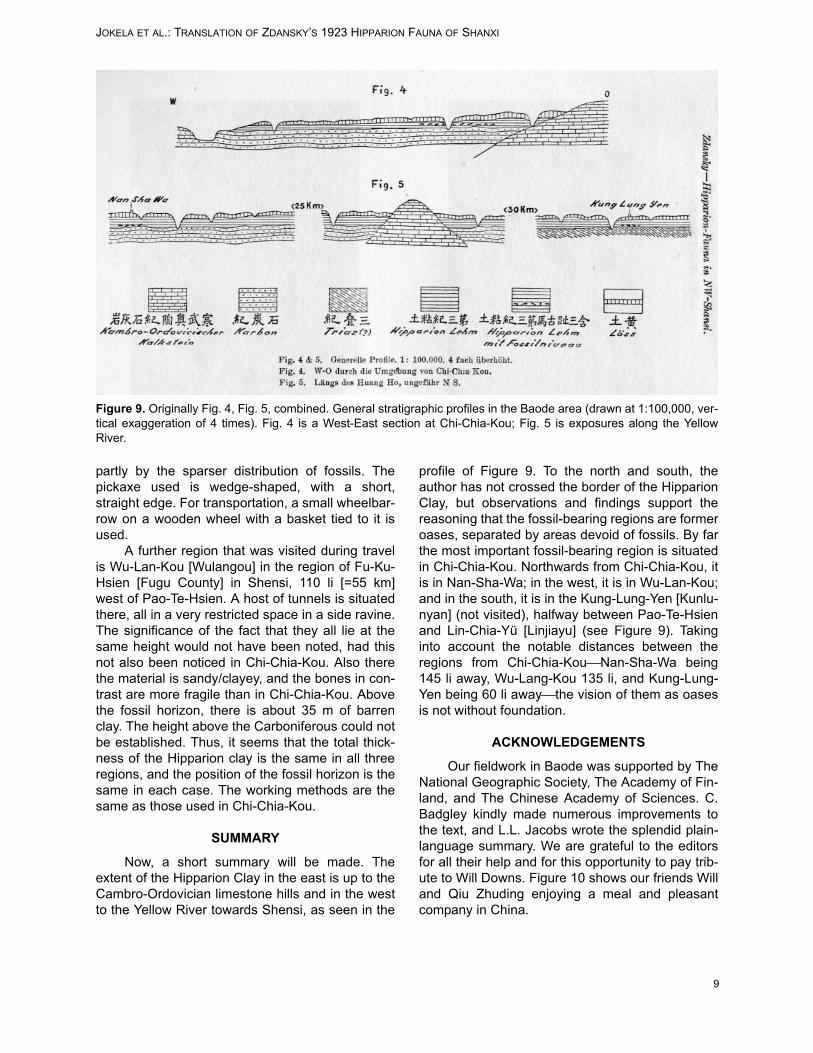
Now, a short summary will be made. Theextent of the Hipparion Clay in the east is up to theCambro-Ordovician limestone hills and in the westto the Yellow River towards Shensi, as seen in the
profile of Figure 9. To the north and south, theauthor has not crossed the border of the HipparionClay, but observations and findings support thereasoning that the fossil-bearing regions are formeroases, separated by areas devoid of fossils. By farthe most important fossil-bearing region is situatedin Chi-Chia-Kou. Northwards from Chi-Chia-Kou, itis in Nan-Sha-Wa; in the west, it is in Wu-Lan-Kou;and in the south, it is in the Kung-Lung-Yen [Kunlu-nyan] (not visited), halfway between Pao-Te-Hsienand Lin-Chia-Yü [Linjiayu] (see Figure 9). Takinginto account the notable distances between theregions from Chi-Chia-KouNan-Sha-Wa being145 li away, Wu-Lang-Kou 135 li, and Kung-Lung-Yen being 60 li awaythe vision of them as oasesis not without foundation.
ACKNOWLEDGEMENTS
Our fieldwork in Baode was supported by TheNational Geographic Society, The Academy of Fin-land, and The Chinese Academy of Sciences. C.Badgley kindly made numerous improvements tothe text, and L.L. Jacobs wrote the splendid plain-language summary. We are grateful to the editorsfor all their help and for this opportunity to pay trib-ute to Will Downs. Figure 10 shows our friends Willand Qiu Zhuding enjoying a meal and pleasantcompany in China.
Figure 9. Originally Fig. 4, Fig. 5, combined. General stratigraphic profiles in the Baode area (drawn at 1:100,000, ver-tical exaggeration of 4 times). Fig. 4 is a West-East section at Chi-Chia-Kou; Fig. 5 is exposures along the YellowRiver.

JOKELA ET AL.: TRANSLATION OF ZDANSKY’S 1923 HIPPARION FAUNA OF SHANXI
10
Figure 10. Dong Weilin (Will Downs) and Qiu Zhuding at dinner in China.