triangulation operations are not confined to one area at any one time. several operations are...
TRANSCRIPT


triangulation operations are not confined to one area at any one time. Several operations are involved in triangulation. The personnel involved in each phase are usually separated from the personnel performing other phases of the survey. Since different lengths of time are required for the various operations, no standard division of duties can be made. There are general operations that must be performed in triangulation, and each of the survey personnel is assigned to one or more of these functions. The general operations are as follows:
Concept of triangulation survey

Steps in triangulation
Reconnaissance and planning.Determination of angles.Base measurement.ComputationMeasurment and baselineElectron of signals and towerMeasurment of horizontal angle
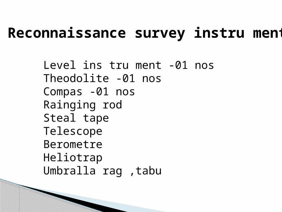
Reconnaissance survey instru ment
Level ins tru ment -01 nosTheodolite -01 nosCompas -01 nosRainging rodSteal tapeTelescopeBerometreHeliotrapUmbralla rag ,tabu
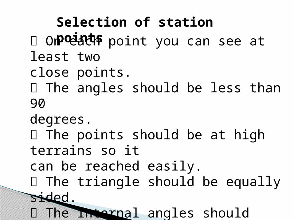
Selection of station points On each point you can see at least
twoclose points. The angles should be less than 90degrees. The points should be at high terrains so itcan be reached easily. The triangle should be equally sided. The internal angles should measured by the theodolite.

Signal:a marker or tower erected at triangulation stations and, sometimes, at traverse stations. Surveying signals are used in mounting geodetic instruments, such as transits, at a height that provides for line of sight to adjacent markers. The distance to the adjacent markers depends on the order of precision of triangulation and ranges from 5–10 km to 30–50 km. Sighting targets are mounted on the surveying signals.

Surveying signals may be simple or complex. A simple signal consists of two pyramids that do not touch—an inner one and an outer one. The inner pyramid is usually trihedral and serves as a base or mounting for the geodetic instrument.

A tower from which signals are set or displayed, as by a semaphore, or by any other means of transmitting information or orders to a distance.Specifically, an armored tower or inclosure above the deck of a war-ship to protect the signalmen when hoisting signals in action.
Signal tower


Height of Eiffel Tower - An ExampleHeight of Tower Baseline Distance Tangent of Angle of Elevation Height of Man =× + ( )( )HT HE HMHeight of Tower Baseline Distance Tangent of Angle of Elevation Height of Man =× + ( )( ))

The Eiffel Tower: • is in Paris, France • built in two years • construction began in 1887 • weighs 7000 tons • has 2.5 million rivets • sways at most 12 cm in high winds • has 40 tons of paint • varies in height up to 15 cm (depending on temperature

Height of Tower = (Baseline Distance ×Tangent of Angle of Elevation )+Height( of Man )
HT HE HM
Given: Baseline Distance = 355 MetersAngle of Elevation = 40o
Height of Man = 2 Meters
Find: Height of Tower
Using the tangent table, we find that: Tan∠40o = 0.84

Height of Tower = (Baseline Distance ×Tangent of Angle of Elevation )+Height( of Man )
355 m X 0.84 + 2 m
298 m + 2 m
300 m Answer

Procedure:Form teams of two students with the following assignments1. For practice, students should take turns sighting on various objects fromdifferent distances with the altitude finder, including releasing the triggerand reading the angle of elevation. Students should compare results.2. Students should review what data is to be collected for each altitudemeasuring event. • angle of elevation • eye level of site • baseline distance.
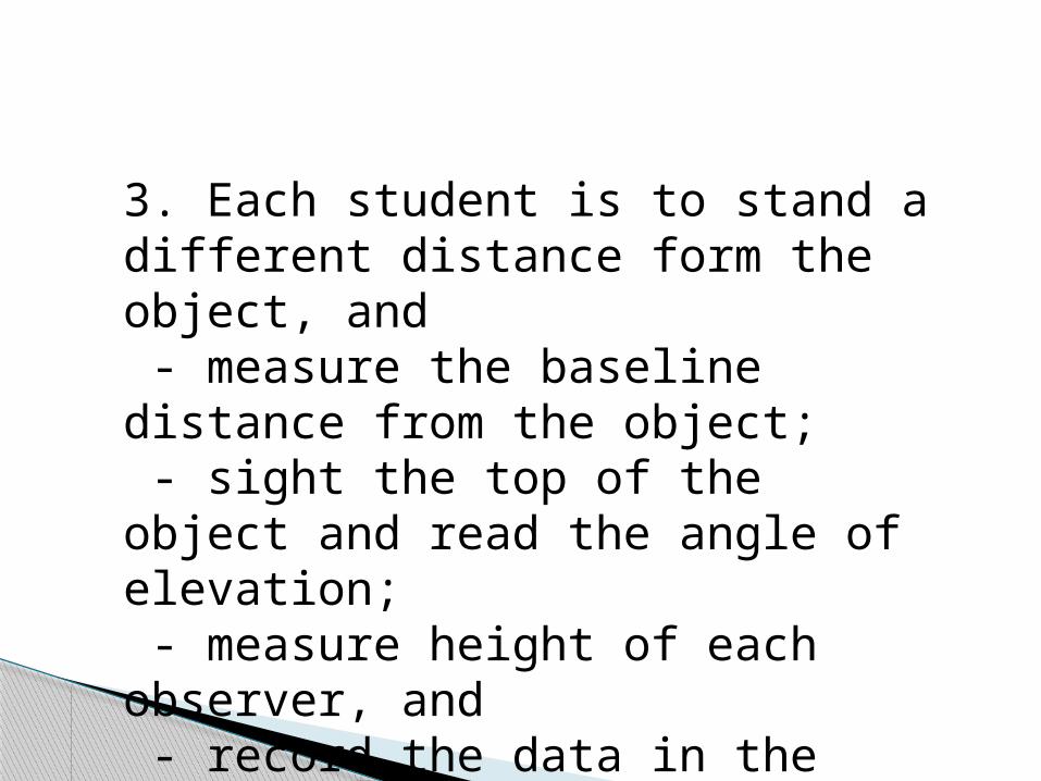
3. Each student is to stand a different distance form the object, and - measure the baseline distance from the object; - sight the top of the object and read the angle of elevation; - measure height of each observer, and - record the data in the table below

4. Use the Table of Tangents to find the tangent of the angles of elevation;Round the tangent to hundredths.6. Compute the (height of the object) using the data from the table.
NameofSightersHeightofSightersBaselineDistanceAngleofElevationTangentofAngleTangentof Angle(hundredths)

Find the Distance Across the Lake
Roy wishes to find the distance across the lake. From where he is standing he can see the 300 meter high TV tower across the lake. He holds the meter stick at eye level 50 centimeters from his face. He slowly moves the meter stick upwards until its top is in line with the top of the tower. He notes that he has moved the meter stick 30 centimeters. His eye height is 180 centimeters.
1. Label the diagram.
2. Write a proportion that can be used to find the distance, D, across the lake.
3. Solve the proportion to find the distance in meters across the lake.

50 cm
30 cm
180 cm
300 m
L 30000 −180 = 3050L : 2982050 = 30L 994
= 150
L =994 ×50 =49,700 cm =497 m