trout lake conservation reserve (c2334) resource...
TRANSCRIPT
Trout Lake Conservation Reserve (C2334)
Resource Management Plan
Ministry of Natural Resources Red Lake District November 2005

2
TABLE OF CONTENTS
1. MISSION STATEMENT 4
1.1 Anishinaape History on Trout Lake 4
2. INTRODUCTION TO THE TROUT LAKE CONSERVATION RESERVE
2.1 Regional Setting 5 2.2 Area Description 6 2.3 Establishment of the Trout Lake Conservation Reserve 7
3. CONSERVATION RESERVE PLANNING 3.1 The Planning Process 8 3.2 The Planning Team 9 3.3 Public Consultation 9
4. PLANNING ISSUES, GOAL AND OBJECTIVES 4.1 Planning History 10
4.2 Management Issues 11 4.3 Goal and Objectives 12 5. MANAGEMENT DIRECTION 5.1 Access 5.1.1 Description 12 5.1.2 Management Direction 13 5.1.3 Management Strategies 14 5.1.4 Rationale for Management Strategies 15
5.2 Crown Land Use
5.2.1 Description 17 5.2.2 Management Direction 18 5.2.3 Management Strategies 19 5.2.4 Rationale for Management Strategies 22
5.3 Resource Use 5.3.1 Description 22
5.3.2 Management Direction 23 5.3.3 Management Strategies 23 5.3.4 Rationale for Management Strategies 25
3
5.4 Recreational and Subsistence Fishery 5.4.1 Description 25
5.4.2 Management Direction 25 5.4.3 Management Strategies 26 5.4.4 Rationale for Management Strategies 27 5.5 Wildlife
5.5.1 Description 27 5.5.2 Management Direction 29 5.5.3 Management Strategies 29 5.5.4 Rationale for Management Strategies 30 6. PLAN IMPLEMENTATION
6.1 Inventory, Monitoring, Assessment and Review 30 6.2 Plan review and Amendment 31
7. SUMMARY 31
FIGURES Figure 1: Parks and Protected Areas 6 Figure 2: Location Map 7 Figure 3: Access Trails 16 Figure 4: Structures ` 20
APPENDICES Planning Team Structure Appendix I Implementation Priority Appendix II Aboriginal History Appendix III Aboriginal Use of Fire Appendix IV Maximum Sustainable Yield Calculations Appendix V Earth and Life Science Report Appendix VI
4
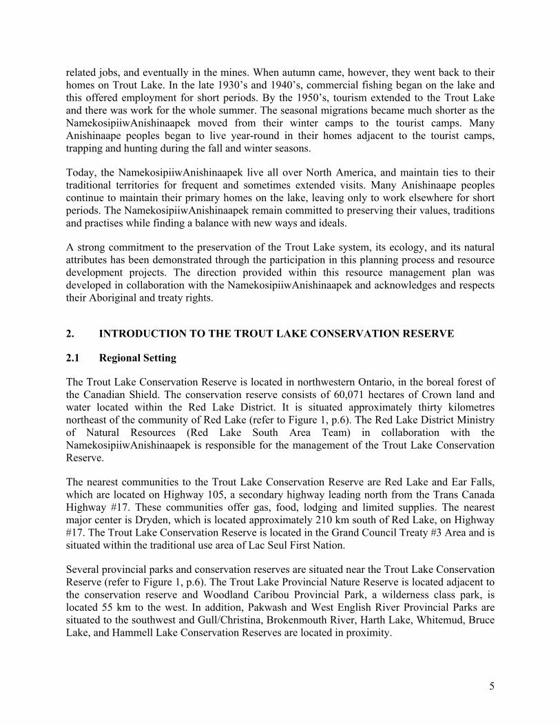
1. MISSION STATEMENT The Mission Statement of the Trout Lake Conservation Reserve is to protect the natural and special landscape of Trout Lake: its water and fishery, eagle and osprey nesting sites, moose and caribou calving islands, wolf, bear and wolverine denning sites, all living creatures, and to protect and preserve the history and culture of the NamekosipiiwAnishinaapek (the Trout Lake Ojibwe). 1.1 Anishinaape History The Trout Lake Conservation Reserve makes an important contribution to the natural heritage representation through its many islands, peninsulas, and shoreline features and by its significant fish and wildlife values. This conservation reserve provides excellent remote public recreational opportunities while supporting a high value tourism industry. In addition, the uniqueness of the conservation reserve is characterized by a rich cultural landscape, essential to the traditional lifestyle of the NamekosipiiwAnishinaapek. The Anishinaapek history and the significance of Trout Lake to its people prior to the signing of the treaty at Lac Seul in 1874, has been handed down through oral tradition. It is important to distinguish this written documentation from both oral histories (stories people tell each other about everyday events and relations, often across generations) and oral tradition (more formal histories that in other times were reserved for specific telling) in that translating those words to text change them. Through face-to-face communication, in the language of the Anishinaapek, the full power of oral history possible. For the purposes of telling this story to those who are not in a position to access oral history, the written word is used here. It does not mean that this tradition is lost or abandoned; rather, it is a temporary substitute and the NamekosipiiwAnishinaapek are committed to keeping and maintaining the oral tradition. The true story of Trout Lake lives in the memories and experiences of its people, the NamekosipiiwAnishinaapek (refer to Appendix III). It is etched on its rocky shores and sandy beaches, on Pinesiwachiink, the ridge that defines its western shores, on the islands, reefs and waters -- everywhere that its people walked, paddled, lived and flourished. As recently as eighty years ago, Trout Lake supported hundreds of Anishinaape peoples in villages and camps around the lake and inland. They arrived in autumn (late August or early September) in time for the seasonal feast before harvesting wild rice, trout and whitefish. By the end of October, families were dispersing to their hunting and trapping areas. Over the winter, the NamekosipiiwAnishinaapek subsisted on moose, beaver, other small game, and foods that were gathered over the summer such as blueberries. Every day there was movement around the lake, people walking on snowshoes to hunt and visit or move camp. In the spring, during break-up, the NamekosipiiwAnishinaapek held ceremonies and feasts and began their seasonal move to lakes further south. At the same time, the Berens River Anishinaapek began their move towards Trout Lake. The rhythm of these migrations was disrupted with the gold rush and the damming of the English River at Ear Falls. The NamekosipiiwAnishinaapek continued these yearly cycles, adjusting to the influx of prospecting, mining and transportation by working on the tugboats, portages, other
5
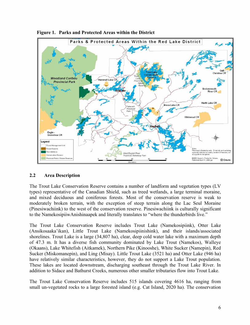
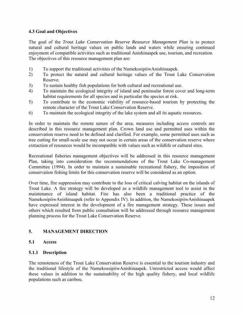
related jobs, and eventually in the mines. When autumn came, however, they went back to their homes on Trout Lake. In the late 1930’s and 1940’s, commercial fishing began on the lake and this offered employment for short periods. By the 1950’s, tourism extended to the Trout Lake and there was work for the whole summer. The seasonal migrations became much shorter as the NamekosipiiwAnishinaapek moved from their winter camps to the tourist camps. Many Anishinaape peoples began to live year-round in their homes adjacent to the tourist camps, trapping and hunting during the fall and winter seasons. Today, the NamekosipiiwAnishinaapek live all over North America, and maintain ties to their traditional territories for frequent and sometimes extended visits. Many Anishinaape peoples continue to maintain their primary homes on the lake, leaving only to work elsewhere for short periods. The NamekosipiiwAnishinaapek remain committed to preserving their values, traditions and practises while finding a balance with new ways and ideals. A strong commitment to the preservation of the Trout Lake system, its ecology, and its natural attributes has been demonstrated through the participation in this planning process and resource development projects. The direction provided within this resource management plan was developed in collaboration with the NamekosipiiwAnishinaapek and acknowledges and respects their Aboriginal and treaty rights. 2. INTRODUCTION TO THE TROUT LAKE CONSERVATION RESERVE 2.1 Regional Setting The Trout Lake Conservation Reserve is located in northwestern Ontario, in the boreal forest of the Canadian Shield. The conservation reserve consists of 60,071 hectares of Crown land and water located within the Red Lake District. It is situated approximately thirty kilometres northeast of the community of Red Lake (refer to Figure 1, p.6). The Red Lake District Ministry of Natural Resources (Red Lake South Area Team) in collaboration with the NamekosipiiwAnishinaapek is responsible for the management of the Trout Lake Conservation Reserve. The nearest communities to the Trout Lake Conservation Reserve are Red Lake and Ear Falls, which are located on Highway 105, a secondary highway leading north from the Trans Canada Highway #17. These communities offer gas, food, lodging and limited supplies. The nearest major center is Dryden, which is located approximately 210 km south of Red Lake, on Highway #17. The Trout Lake Conservation Reserve is located in the Grand Council Treaty #3 Area and is situated within the traditional use area of Lac Seul First Nation. Several provincial parks and conservation reserves are situated near the Trout Lake Conservation Reserve (refer to Figure 1, p.6). The Trout Lake Provincial Nature Reserve is located adjacent to the conservation reserve and Woodland Caribou Provincial Park, a wilderness class park, is located 55 km to the west. In addition, Pakwash and West English River Provincial Parks are situated to the southwest and Gull/Christina, Brokenmouth River, Harth Lake, Whitemud, Bruce Lake, and Hammell Lake Conservation Reserves are located in proximity.
6
Figure 1. Parks and Protected Areas within the District
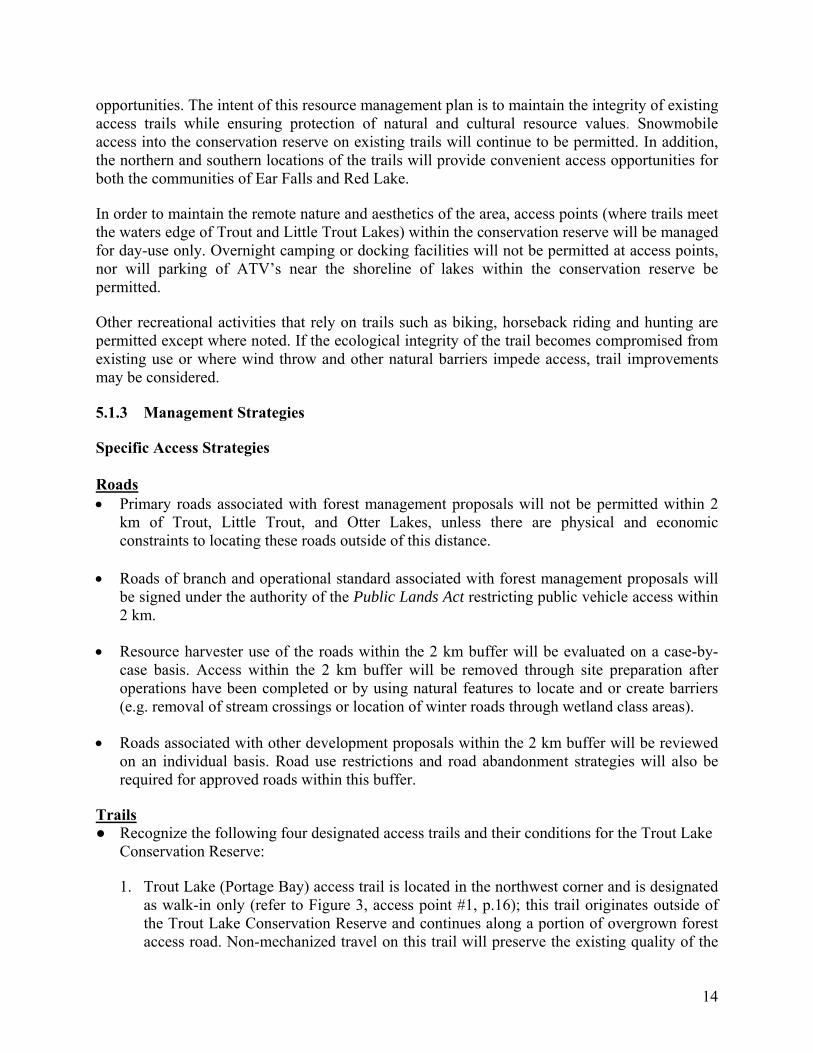
2.2 Area Description The Trout Lake Conservation Reserve contains a number of landform and vegetation types (LV types) representative of the Canadian Shield, such as treed wetlands, a large terminal moraine, and mixed deciduous and coniferous forests. Most of the conservation reserve is weak to moderately broken terrain, with the exception of steep terrain along the Lac Seul Moraine (Pinesiwachiink) to the west of the conservation reserve. Pinesiwachiink is culturally significant to the NamekosipiiwAnishinaapek and literally translates to “where the thunderbirds live.” The Trout Lake Conservation Reserve includes Trout Lake (Namekosipiink), Otter Lake (Ansikosaaka’ikan), Little Trout Lake (Namekosipiinishink), and their islands/associated shorelines. Trout Lake is a large (34,807 ha), clear, deep cold water lake with a maximum depth of 47.3 m. It has a diverse fish community dominated by Lake Trout (Namekos), Walleye (Okaans), Lake Whitefish (Aitkamek), Northern Pike (Kinooshe), White Sucker (Namepin), Red Sucker (Miskomanepin), and Ling (Misay). Little Trout Lake (3521 ha) and Otter Lake (946 ha) have relatively similar characteristics, however, they do not support a Lake Trout population. These lakes are located downstream, discharging southeast through the Trout Lake River. In addition to Sidace and Bathurst Creeks, numerous other smaller tributaries flow into Trout Lake. The Trout Lake Conservation Reserve includes 515 islands covering 4616 ha, ranging from small un-vegetated rocks to a large forested island (e.g. Cat Island, 2020 ha). The conservation

7
reserve encompasses over 850 km of mainland and island shoreline, primarily on Trout Lake. The shorelines are predominately rocky, but numerous large sandy beaches are found in sheltered bays, notably on Hudson Bay Point (Ketewaakaa’ikanikaank) and Keesic Bay (Kaaminitikwaashkiikaak). There are four main base lodge tourism facilities, located within the Trout Lake Conservation Reserve, which are located on patent land. Although these properties are surrounded by the conservation reserve, private lands are excluded, and therefore are not directly affected by the conservation reserve policy or this management plan. *Note: Although these properties are on private land, their activities are carried out within the conservation reserve. Figure 2. Location and Boundary of the Trout Lake Conservation Reserve
N
Red Lake
Cochenour
Little Trout Lake
Otter Lake
Trout LakeProvincial NatureReserve
Trout Lake Conservation Reserve
8 0 8 16 Kilometers
This map is illustrative only. Do not rely on it as being a precise indicator of routes, locations of features, nor as a guide to navigation.(c) 2003, Queen's Printer for OntarioOntario, Canada
Balmertown
#
#
#
2.3 Establishment of the Trout Lake Conservation Reserve The Ontario’s Living Legacy Land Use Strategy, which guides the planning and management of Crown land in central and parts of northern Ontario, was approved on July 16, 1999. As part of the planning process, round tables provided the Anishinaapek, stakeholders and the general public with an opportunity to provide input on what areas could be protected within their respective district. The NamekosipiiwAnishinaapek took a leading role by requesting that Trout Lake become a protected area. The Ontario’s Living Legacy Land Use Strategy recommended the establishment of 378 new protected areas, which included the Trout Lake Conservation Reserve.
8
Conservation reserves are dedicated protected areas which complement the provincial parks system by contributing to the protection of representative natural areas and special landscapes. Commercial timber harvesting, mineral exploration and mining, aggregate extraction and commercial hydroelectric development are not permitted in conservation reserves. Recreational pursuits (e.g. hiking, skiing, tourism related uses and nature appreciation) and non-industrial activities (e.g. fur harvesting, wild rice harvesting, and bait harvesting) will continue, provided that these uses do not impact the natural features requiring protection. In addition, hunting and fishing are permitted within in the Trout Lake Conservation Reserve. Prior to its regulation, the boundary of the recommended Trout Lake Conservation Reserve was examined to determine its appropriateness and effectiveness in capturing the required values of the area. Two portions of land, one south and one west of the Trout Lake Provincial Nature Reserve that were identified as part of the recommended conservation reserve were removed from the site. As a result, equal area was added to other shoreline locations, which include several peninsulas. During this boundary refinement process, ecological and cultural values were a primary consideration. Some examples include important landform and vegetation features, watershed values, wildlife values (e.g. caribou calving areas) and cultural values (e.g. Anishinaapek harvesting areas, campsites, and burial grounds). In addition, the viewscape (the landscape that visitors see as they travel along the lake) was also considered and is a concern to many Trout Lake tourism operators. Where it was possible, areas with these multiple values were incorporated into the conservation reserve boundary. The proposed Trout Lake Conservation Reserve boundaries were subject to a public review by affected stakeholders and the First Nation communities between June 15 and July 15, 2001. As a result, some additional boundary adjustments were made to accommodate natural and cultural resource values. Upon final approval of the conservation reserve boundary, an amendment to the Sustainable Forest Licence (SFL) for the Trout Lake Forest was processed to remove the conservation reserve from the commercial forest land base. The Trout Lake Conservation Reserve was regulated on May 21, 2003. Affected stakeholders, First Nation communities and the public were notified through the posting of an Environmental Bill of Rights (EBR) decision notice, local news releases and mail-outs. 3. CONSERVATION RESERVE PLANNING 3.1 The Planning Process Conservation reserves are regulated under Section 4 of the Public Lands Act. Following regulation, a conservation reserve must undergo a planning exercise to determine the future management direction for the site. According to MNR policy, an appropriate planning document (e.g. a Statement of Conservation Interest or a Resource Management Plan) must be completed within three years of the regulation date.
9
In most cases, management direction for a conservation reserves takes the form of a Statement of Conservation Interest (SCI). An SCI is used when the conservation reserve is known to have few or no issues associated with it. Any existing local issues are addressed through application of existing policy. A Resource Management Plan (RMP) is a form of planning used when a conservation reserve has issues that are more complex. Based on these criteria, a Resource Management Plan is considered appropriate for the Trout Lake Conservation Reserve. The Resource Management Plan will provide a sufficient level of planning and consultation to address the management objectives of the Trout Lake Conservation Reserve and the known concerns of the NamekosipiiwAnishinaapek, the public, and Trout Lake stakeholders. The Trout Lake Conservation Reserve Resource Management Plan will provide long-term strategic direction on resource management activities and appropriate land uses within the Trout Lake Conservation Reserve. It will be consistent with the MNR's strategic directions document Our Sustainable Future. 3.2 The Planning Team
The Red Lake District MNR in collaboration with the NamekosipiiwAnishinaapek was responsible for preparing, reviewing, producing, and distributing the Resource Management Plan (refer to Appendix I for a complete list). A Planning Project Team comprised of the District Planner, Planning Assistant, and the Area Supervisor for Red Lake South was established to develop the resource management plan, coordinate public consultation and ensure that policies in this plan are integrated with other district planning activities. The planning team was assisted by district advisors who have provided input and advice on natural resource management issues pertaining to the Trout Lake Conservation Reserve and adjacent areas during the resource management planning process. This team included an Area Biologist, Senior Lands Specialist, and a Conservation Officer. The NamekosipiiwAnishinaapek team provided insight and advice about the Trout Lake area. The oral history of the area, identification of cultural values, and the mission for this conservation reserve, were key contributions to this resource management plan. The NamekosipiiwAnishinaapek have also reviewed and commented on draft documents and strategies produced by the MNR Planning Project Team. 3.3 Public Consultation The first stage of the planning process, “Invitation to Participate” occurred in the fall of 2003. During this period, meetings were held with the NamekosipiiwAnishinaapek and primary interest groups consisting of tourist operators, and the local angler and hunter clubs. Next, on November 2003, the second stage of the draft plan, “Public Review” occurred. The November session included an information centre held on November 14, 2003 at the MNR Red Lake District Office. The purpose of this session was to gather comments from a broader public audience on management strategies and options for the Trout Lake Conservation Reserve. On August 2005,
10
the third and final stage, “Public Inspection” of the approved resource management plan occurred. At each stage of the planning process, First Nations, major stakeholders, and other interest groups were notified via a mail-out letter and by advertisement in the local newspapers (The Red Lake Review and The Northern Sun). In addition, an Environmental Bill of Rights notice posted on the internet. The EBR notice ensured that the public was made aware of the opportunities for input into the planning process at a provincial level. 4. PLANNING ISSUES, GOAL AND OBJECTIVES The Ministry of Natural Resources uses resource management planning to arrive at decisions concerning the allocation and management of Ontario’s natural resources. The intent is that resource management planning will aid in providing social, economic, and environmental benefits to the people of Ontario. The Trout Lake Conservation Reserve Resource Management Plan guides where, when and how resource management activities will be carried out. Planning decisions will be made based on the best available information and will include the participation of affected and interested parties. Management of the Trout Lake Conservation Reserve includes, as a minimum, regulation, provision of public information, stewardship, and security. It also includes authorization and setting conditions on permitted uses and ongoing monitoring of compliance within the approved resource management plan. Management of conservation reserves is the responsibility of the Ministry of Natural Resources at the district level, and is carried out in accordance with Policy PL 3.03.05. The NamekosipiiwAnishinaapek also manage themselves through a set of values that have been taught from one generation to the next. These traditional management practices demonstrate respect, responsibility, and a relationship of reciprocity with the land and ensure sustainability and balance within the Trout Lake ecosystem. 4.1 Planning History A long history of management planning exists in the Trout Lake area. The West Patricia Land Use Planning (WPLUP) program, which was initiated in the late 1970,’s in recognition of the increasing importance of natural resource development and settlement in Northwestern Ontario. The WPLUP program applied specifically in the administrative districts of Red Lake, Sioux Lookout, and the western portion of Geraldton. Although WPLUP was never completed, various studies and analyses of natural resources, culture, tourism, and recreational information associated with this initiative provided important background material in the development of this management plan. During the late 1980’s the Trout Lake Co-management Committee was formed to deal with forest harvest and access issues, tourism, and recreational opportunities for the Trout Lake area. In January 1994, the committee submitted a report and management recommendations to resolve
11
recreational fisheries issues within the co-management area. As a result, consultation occurred with the Anishinaape communities and with the public. The NamekosipiiwAnishinaapek did withdraw from the group because they felt under represented. A number of recommendations were implemented; however, some recommendations are remaining and will be fulfilled through this conservation reserve management planning process. 4.2 Management Issues
1. Resource management plans provide long-term direction for protected areas and its values; however, it is difficult to anticipate all issues related to resource use. With the implementation of the Ontario's Living Legacy Land Use Strategy, new designations such as the Trout Lake Conservation Reserve now receive a higher profile and it is likely that additional pressures on the resource may occur.
2. Although Crown land camping is currently not an issue, over time recreational camping
may increase to a point where identified fish and wildlife values and cultural heritage sites may become at risk. In anticipation, a request to implement a Regulated Crown Land Camping Zone was received during the public consultation process. This option as well as signing of islands and points of land will be evaluated. In addition, an increase in recreational use by the public is a concern to the NamekosipiiwAnishinaapek and existing commercial tourism businesses.
3. Currently, the Trout Lake Conservation Reserve has thirteen Anishinaapek cabins
requiring tenure and status for future use. Through consultation with individual band members and Chief and Council of Lac Seul First Nation, a review and decision making process will, as required, evaluate the need and purpose of each cabin as well as future Anishinaapek development proposals.
4. Through the implementation of this resource management plan and as a consequence of
the remote nature of the Trout Lake Conservation Reserve, operational constraints on existing stakeholders may limit or restrict the way resources have been utilized and/or accessed (e.g. renewal or maintenance of septic systems will be required over time and at higher costs to the stakeholder).
5. New cultural and/or ecotourism opportunities that are non-consumptive and "light" on the
land may be permitted. These activities will be evaluated on the strength of their business plans and conservation reserve policies and the philosophies of this resource management plan. The capacity of the Trout Lake Conservation Reserve to accommodate these opportunities is limited as well as our ability to determine its threshold.
6. Strategies that require implementation funding such as trail maintenance, signage
(awareness and regulatory), creel and wildlife surveys, and enforcement will need to be identified as new business within the respective MNR program areas.
12
4.3 Goal and Objectives The goal of the Trout Lake Conservation Reserve Resource Management Plan is to protect natural and cultural heritage values on public lands and waters while ensuring continued enjoyment of compatible activities such as traditional Anishinaapek use, tourism, and recreation. The objectives of this resource management plan are: 1) To support the traditional activities of the NamekosipiiwAnishinaapek. 2) To protect the natural and cultural heritage values of the Trout Lake Conservation Reserve. 3) To sustain healthy fish populations for both cultural and recreational use. 4) To maintain the ecological integrity of island and peninsular forest cover and long-term habitat requirements for all species and in particular the species at risk. 5) To contribute to the economic viability of resource-based tourism by protecting the remote character of the Trout Lake Conservation Reserve. 6) To maintain the ecological integrity of the lake system and all its aquatic resources. In order to maintain the remote nature of the area, measures including access controls are described in this resource management plan. Crown land use and permitted uses within the conservation reserve need to be defined and clarified. For example, some permitted uses such as tree cutting for small-scale use may not occur in certain areas of the conservation reserve where extraction of resources would be incompatible with values such as wildlife or cultural sites. Recreational fisheries management objectives will be addressed in this resource management Plan, taking into consideration the recommendations of the Trout Lake Co-management Committee (1994). In order to maintain a sustainable recreational fishery, the imposition of conservation fishing limits for this conservation reserve will be considered as an option. Over time, fire suppression may contribute to the loss of critical calving habitat on the islands of Trout Lake. A fire strategy will be developed as a wildlife management tool to assist in the maintenance of island habitat. Fire has also been a traditional practice of the NamekosipiiwAnishinaapek (refer to Appendix IV). In addition, the NamekosipiiwAnishinaapek have expressed interest in the development of a fire management strategy. These issues and others which resulted from public consultation will be addressed through resource management planning process for the Trout Lake Conservation Reserve. 5. MANAGEMENT DIRECTION 5.1 Access 5.1.1 Description The remoteness of the Trout Lake Conservation Reserve is essential to the tourism industry and the traditional lifestyle of the NamekossipiiwAnishinaapek. Unrestricted access would affect these values in addition to the sustainability of the high quality fishery, and local wildlife populations such as caribou.

13
The most relevant direction regarding forest access for this area originates from the Trout Lake Co-management Committee. This direction has traditionally been contained within the Trout Lake Forest Management Plan. For future roads planning in forest management plans and other road development projects, direction will reside within this resource management plan. Several forest access roads have been constructed in close proximity to the Trout Lake Conservation Reserve, mainly to harvest conifer dominated stands in the area. New road development within this area has the potential to increase accessibility to the Trout Lake Conservation Reserve and the potential to effect woodland caribou habitat and historical predator/prey relationships. Timber harvest roads that may affect the Trout Lake Conservation Reserve include:
1) Otter Road (operational class road) located on the Otter Peninsula of Trout Lake. 2) Castle and Caskie Roads (branch class roads) located on the Caskie Peninsula of Trout
Lake. 3) Mary Road (operational class road) located on the east side of Trout Lake.
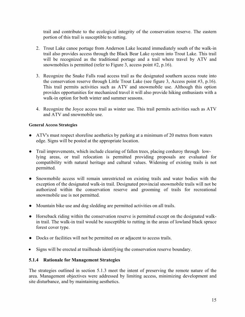
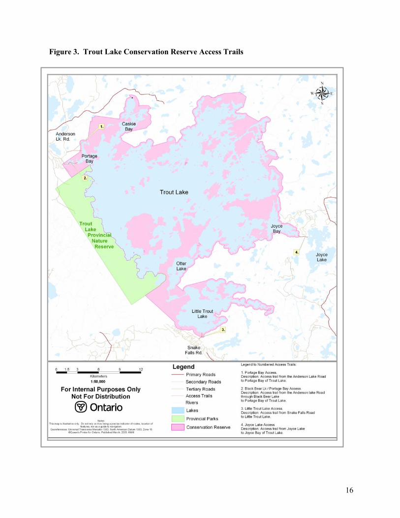
Access trails into the Trout Lake Conservation Reserve are walk-in and ATV (summer use) and snowmobile (winter) access. In addition, a canoe route passes from the Coli Lake system at the northwestern end of the conservation reserve through Trout Lake to the Trout Lake River system. Subsistence and recreational hunters and anglers, commercial bait and fur harvesters, canoeists, hikers, and naturalists use these trails and routes for access into the Trout Lake Conservation Reserve. There are four existing access trails into the Trout Lake Conservation Reserve (refer to figure 3, p.16):
1) Portage Bay Access: trail access from Anderson Lake Road (Kiishaanisaaka’ikaniins) to Portage Bay of Trout Lake, restricted to non-mechanized travel.
2) Bear Lake (Makwasaaka’ikaniinsan)/ Portage Bay (Namepinisaakiink) Access: canoe route overland from Anderson Lake (west of Trout Lake), to portage bay of Trout Lake through Bear Lakes. This access also provides snowmobile access in the winter from Anderson Lake Road to Portage Bay of Trout Lake.
3) Little Trout Lake Access: trail access by ATV or snowmobile from the Snake Falls Road continuing to Little Trout Lake.
4) Joyce Lake Access: trail access by snowmobile only from Joyce Lake to Washashopiinchitawikamaank (Joyce Bay) of Trout Lake. This trail is also used as a summer portage from Trout Lake to Joyce Lake.
5.1.2 Management Direction Limited access into the Trout Lake Conservation Reserve is desired to preserve the remote nature of the area and the sustainability of its natural and cultural heritage. Roads will not be permitted within the conservation reserve unless it was a previous commitment and has met Environmental Assessment Act requirements. Currently, access by ATV directly into Trout Lake at the northwest corner of the conservation reserve is limited. New trail options may be considered when development proposals adjacent to the conservation reserve permit new
14
opportunities. The intent of this resource management plan is to maintain the integrity of existing access trails while ensuring protection of natural and cultural resource values. Snowmobile access into the conservation reserve on existing trails will continue to be permitted. In addition, the northern and southern locations of the trails will provide convenient access opportunities for both the communities of Ear Falls and Red Lake. In order to maintain the remote nature and aesthetics of the area, access points (where trails meet the waters edge of Trout and Little Trout Lakes) within the conservation reserve will be managed for day-use only. Overnight camping or docking facilities will not be permitted at access points, nor will parking of ATV’s near the shoreline of lakes within the conservation reserve be permitted. Other recreational activities that rely on trails such as biking, horseback riding and hunting are permitted except where noted. If the ecological integrity of the trail becomes compromised from existing use or where wind throw and other natural barriers impede access, trail improvements may be considered. 5.1.3 Management Strategies Specific Access Strategies Roads • Primary roads associated with forest management proposals will not be permitted within 2
km of Trout, Little Trout, and Otter Lakes, unless there are physical and economic constraints to locating these roads outside of this distance.
• Roads of branch and operational standard associated with forest management proposals will
be signed under the authority of the Public Lands Act restricting public vehicle access within 2 km.
• Resource harvester use of the roads within the 2 km buffer will be evaluated on a case-by-
case basis. Access within the 2 km buffer will be removed through site preparation after operations have been completed or by using natural features to locate and or create barriers (e.g. removal of stream crossings or location of winter roads through wetland class areas).
• Roads associated with other development proposals within the 2 km buffer will be reviewed
on an individual basis. Road use restrictions and road abandonment strategies will also be required for approved roads within this buffer.
Trails
● Recognize the following four designated access trails and their conditions for the Trout Lake Conservation Reserve:
1. Trout Lake (Portage Bay) access trail is located in the northwest corner and is designated as walk-in only (refer to Figure 3, access point #1, p.16); this trail originates outside of the Trout Lake Conservation Reserve and continues along a portion of overgrown forest access road. Non-mechanized travel on this trail will preserve the existing quality of the
15
trail and contribute to the ecological integrity of the conservation reserve. The eastern portion of this trail is susceptible to rutting.
2. Trout Lake canoe portage from Anderson Lake located immediately south of the walk-in
trail also provides access through the Black Bear Lake system into Trout Lake. This trail will be recognized as the traditional portage and a trail where travel by ATV and snowmobiles is permitted (refer to Figure 3, access point #2, p.16).
3. Recognize the Snake Falls road access trail as the designated southern access route into
the conservation reserve through Little Trout Lake (see figure 3, Access point #3, p.16). This trail permits activities such as ATV and snowmobile use. Although this option provides opportunities for mechanized travel it will also provide hiking enthusiasts with a walk-in option for both winter and summer seasons.
4. Recognize the Joyce access trail as winter use. This trail permits activities such as ATV
and ATV and snowmobile use. General Access Strategies
● ATV's must respect shoreline aesthetics by parking at a minimum of 20 metres from waters edge. Signs will be posted at the appropriate location. ● Trail improvements, which include clearing of fallen trees, placing corduroy through low-
lying areas, or trail relocation is permitted providing proposals are evaluated for compatibility with natural heritage and cultural values. Widening of existing trails is not permitted.
● Snowmobile access will remain unrestricted on existing trails and water bodies with the
exception of the designated walk-in trail. Designated provincial snowmobile trails will not be authorized within the conservation reserve and grooming of trails for recreational snowmobile use is not permitted.
● Mountain bike use and dog sledding are permitted activities on all trails. ● Horseback riding within the conservation reserve is permitted except on the designated walk-
in trail. The walk-in trail would be susceptible to rutting in the areas of lowland black spruce forest cover type.
● Docks or facilities will not be permitted on or adjacent to access trails. • Signs will be erected at trailheads identifying the conservation reserve boundary. 5.1.4 Rationale for Management Strategies
The strategies outlined in section 5.1.3 meet the intent of preserving the remote nature of the area. Management objectives were addressed by limiting access, minimizing development and site disturbance, and by maintaining aesthetics.
16
Figure 3. Trout Lake Conservation Reserve Access Trails
17
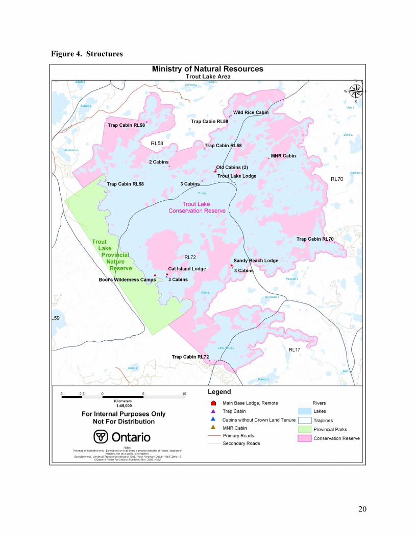
5.2 Crown Land Use 5.2.1 Description Infrastructure Infrastructure exists within the Trout Lake Conservation Reserve in the form of tourist camps, resource harvester cabins, a family residence, and an MNR owned cabin (commercial fish buy-out). Some of these structures are authorized through various forms of tenure such as land use permits and letters of authority. There are four main-base tourist lodges located on patented land within conservation reserve boundaries (refer to Figure 4, p.20):
1. Sandy Beach Lodge near the Otter Peninsula (Pinekakiiwekanaank) at the south end of Trout Lake was established in 1952.
2. Trout Lake Lodge on an island at the north end of Trout Lake was established in 1955. 3. Booi’s Wilderness Lodge and Outpost Ltd. on Booi’s Island in Trout Lake was
established in 1961. 4. Cat Island Lodge on Cat Island in Trout Lake was established in 1962.
Another form of infrastructure found in the conservation reserve includes, six trap cabins that are associated with traplines RL-70, RL-72, and RL-58, and one wild-rice harvesting cabin. There are thirteen structures within the conservation reserve that have no Crown land tenure associated with them (refer to Figure 4, p.20). These structures/cabins represent the Angeconeb, King, Keesick and Olsen NamekosipiiwAnishinaapek families who traditionally occupied Trout Lake. The status of the cabins (or remnants of them) is currently under review. Each of the NamekosipiiwAnishinaapek families continues to maintain ties to their traditional territories and live at Trout Lake on a semi-permanent basis. One example includes three cabins on Olsen Island; the main cabin is located on the original site of a cabin built by Einar Olsen, a Norwegian commercial fisherman who married into the Anishinaapek community in the 1940’s. Although this site is no longer used as a base of operations for commercial fishing, the existing cabins continue to represent the family’s rich history and provide a place for NamekosipiiwAnishinaapek to practice their customs and traditions. Presently, other infrastructure such as energy transmission and communication corridors do not exist within or near the conservation reserve. It is anticipated that this area will never have to accommodate utility corridors. Should future development plans require these structures within the Trout Lake Conservation Reserve, all efforts will be made to minimize the disruption of existing uses and values that are characteristic of the conservation reserve. Currently, signage exists in the Trout Lake Conservation Reserve. For example, signs on Crown land (islands and mainland) are used to direct visitors through the lake systems to lodges which are located within the conservation reserve. In addition, markers have been placed throughout Trout Lake to indicate shoals.
18
Crown Land Camping Camping will continue to be permitted within the Trout Lake Conservation Reserve unless demonstrated conflicts arise with conservation reserve values, however, non-residents of Canada are required to pay a Crown land camping fee. Outfitting Services No camping and canoeing outfitting services exist in the Trout Lake Conservation Reserve however, one main base lodge caters to hunters and all the lodges promote fishing. Shore-lunch Sites Shore-lunches are one of the unique experiences that tourist camps provide to their guests. Currently, there are approximately 50 sites throughout the conservation reserve which include infrastructure varying from fire pits and fish cleaning stations to shelters with dining tables and benches. Through the consultation process, some sites have been identified as impacting the natural landscape, wildlife and/or located on or near cultural sites. Protection of these sensitive sites will be addressed within the strategy (refer to section 5.2.3, p.19) Science, Education and Heritage Appreciation The Trout Lake Conservation Reserve has many unique characteristics and values that present opportunities for historical appreciation, nature appreciation, wildlife viewing, photography, painting, and research. Some of the more interesting features include the Lac Seul Moraine (Pinesiwachiink), which rises above the lake to an elevation of 484 metres. The islands and mainland shorelines reveal an array of aggregate material from large boulders in mass to fine beach sand. In addition, the islands fulfill summer refuge and calving habitat requirements for a significant number of woodland caribou. Furthermore, the islands represent a rich and diverse plant community with old growth attributes common to forest cover that has evolved through a lower fire frequency. Trout Lake is rich in cultural history with many traditions that continue to be active today (refer to Appendix III & IV). Boat Caches Boat caches located on Crown land are dispositions under the Public Lands Act. These caches are authorized through agreements administered by the district MNR office via the Northwest Region Boat Cache Program. There are three categories of boat caches under agreement and include private recreational, commercial, and resource harvester. The Trout Lake Conservation Reserve currently restricts new private and commercial boat caches with the exception of a previous commitment with the Trout Lake Co-management Committee to provide a limited number of boat caches for the local angler and hunter clubs located in Ear Falls and Red Lake. The four main base lodges are on patent land and do not require boat cache agreements. These boats reside at their respective commercial establishment and are for use on Trout, Otter and Little Trout lakes. None of the lodges have commercial boat caches on adjacent lakes that fall within the conservation reserve. Resource harvester boats that are currently under agreement within this conservation reserve are for the purpose of trapping. 5.2.2 Management Direction Low impact activities within this environment and respect for the land, water, and wildlife will be encouraged.
19
Existing infrastructure located on Crown land will remain unless it is deemed unauthorized and/or found to be incompatible with natural or cultural heritage values in the conservation reserve. In addition, existing structures located on Crown land must be used for their designated purpose. Anishinaape peoples practicing traditional activities (e.g. trapping, hunting, fishing and gathering within the conservation reserve may construct a cabin provided the structure is recognized as a community cabin for the purposes of carrying out an Aboriginal or treaty right. The location of the structure must be compatible with conservation reserve, natural heritage and cultural values, and approved by the Ministry of Natural Resources. Crown land dispositions within the Trout Lake Conservation Reserve will be limited to land use permits. Currently, one land use permit (LUP) for a wild rice cabin is issued on an annual basis. Sale of Crown land will only be considered in support of existing establishments (e.g. reconstruction of a septic system). The four trap cabins are authorized under the authority of the Trapping Licence. The four main base lodges are located on patent land. Cabins not falling under the authorization of the Public Lands Act will be evaluated through a screening process to determine their status. New commercial facilities may also be considered where low impact economic opportunities exist. New private recreational boat caches (limited to 4) will be established at the designated access points through boat cache agreements with local angler and hunter clubs. In addition, new resource harvester boat caches and boats required for transportation will be considered on a case-by-case basis. No new commercial boat caches will be considered. All known shore-lunch sites will be evaluated in consultation with the NamekosipiiwAnishinaapek and the Trout Lake tourist outfitters to determine if any natural, heritage and/or cultural value conflicts exist. The Ministry of Natural Resources will respect and honour Aboriginal and treaty rights when making and implementing plans. The Ministry of Natural Resources plans will not prejudice any land claims recognized by Ontario and Canada. 5.2.3 Management Strategies Infrastructure
• Existing infrastructure: Existing infrastructure on Crown land will be removed, or relocated if found to be incompatible with conservation reserve values or in contravention with MNR's Free Use Policy PL 3.03.01. For trap cabins, (refer to section 5.3.3, p.23).
• New infrastructure:
A limited number of commercial opportunities may be available in the conservation reserve.
20
Figure 4. Structures
21
• Business plans proposing facilities for new non-consumptive cultural ecotourism activities on Crown land (e.g. educational purposes, cultural awareness, or traditional Anishinaapek use) will be considered and subject to the Application Review and Land Disposition Process PL 4.02.01. Private recreational camps on Crown land will not be permitted. Anishinaapek proposals for new cabins will be evaluated on a case by case basis.
• Remove all signs and shoal markers located on Crown land within the conservation reserve unless deemed necessary for the personal safety of boaters.
Crown Land Camping
• Overnight camping will not be permitted on access trails on or adjacent to the lakeshore. Restrictions will be communicated through signs erected at the established trailhead.
• A Non-Resident of Canada Regulated Camping Zone* will be considered when resource values and natural features within the conservation reserve are at risk due to additional pressure on the resources from user groups.
• Commercial campgrounds will not be permitted. *Note: This is a regulation under the Public Lands Act. Non-residents of Canada visiting the Trout Lake Conservation Reserve will be required to stay at licensed tourist camp. Where facility based operations promote camping or where canoe/ kayaking outfitters promote tripping within the conservation reserve, predetermined sites will be designated to facilitate this recreational activity. This direction permits a broader clientele in any future opportunities (e.g. ecotourism, educational purposes) where camping activities are enjoyed. Designated sites will be removed from the Regulated Camping Zone. Crown Land Dispositions
• The sale of Crown land is not permitted except for minor dispositions in support of existing uses (e.g. reconstruction of a septic system). Renewals of existing leases and land use permits (LUPs) are permitted. Land tenure for new dispositions will be authorized through land use permits only.
Shore-lunch Sites
• All shore-lunch sites will be evaluated to determine which are necessary and compatible with conservation reserve values.
• Shore-lunch sites with infrastructure (e.g. site with a table or bench) will require a land use permit (LUP) to remain on Crown land
• No new shore-lunch sites/ structures will be permitted • Users must leave shore-lunch sites in a natural state (e.g. packing out garbage, tools and
cooking oil, etc.) • MNR will provide tourist operators with best practices guidelines for shore-lunch
activities Outfitting Services • Services will be permitted through an established tourist outfitter or a new ecotourism opportunity

22
• Subject to individual review, a limited number of non-consumptive ecotourism facilities may be permitted Science, Education and Heritage Appreciation ● These activities are encouraged within the Trout Lake Conservation Reserve.
Boat Caches ● Two new private recreational boat cache opportunities will be provided at each designated
access trail (access trails 2 & 3). Additional private and commercial boat caches will not be considered unless associated with a new ecotourism opportunity, transportation and/or is considered an Aboriginal and treaty right.
*Note: The private boat cache agreements will be with local angler and hunter clubs. ● New resource harvester boat caches will be considered on a case-by-case basis. 5.2.4 Rationale for Management Strategies
The intent of the resource management plan is to implement strategies that encourage enjoyment of Crown land while protecting conservation reserve values such as cultural and natural heritage, remoteness, and aesthetics. The management strategies for boat caches takes direction from the Trout Lake Co-management Committee Recommendations (1994). 5.3 Resource Use 5.3.1 Description Currently, the commercial harvest of resources such as fur, baitfish, and wild rice are activities occurring within the conservation reserve. Additional commercial activities promoted through the establishment of tourist camps include, sport hunting for black bear and moose. Baitfish Harvest: Baitfish blocks delineated by the old forest resource inventory (FRI) base map system and have a fixed boundary. Where a sale has occurred, the respective blocks are then transferred to the new owner and are listed on the owners' license. All water bodies within the conservation reserve are currently licensed to four separate companies and are represented by seven baitfish blocks. Fur Harvest Five actively managed trap lines intersect the boundaries of the conservation reserve. These traplines are within Grand Council Treaty #3 and the Lac Seul Band traditional use area. Trap line transfers will be a collaborative process between Grand Council Treaty #3, the Local Aboriginal Trapping Council and the MNR. Trapline transfers to Anishinaape peoples are encouraged on a “willing seller-willing buyer” basis. All applicants must meet trapping requirements under the fur harvest guidelines or as described in the Grand Council Treaty #3 Trapping Harmonization Agreement.
23
Bear Management Areas Non-residents of Canada who wish to hunt bear must employ a tourist operator with an established Bear Management Area (BMA). Currently, there are six BMA's that intersect the boundaries of the Trout Lake Conservation Reserve. Agreements for BMA’s that are not renewed and are deemed vacant will be available for reallocation. Wild Rice Harvest One wild rice harvester holds four active licences, which include RL 49 (Jackfish Bay, Trout Lake), RL 51 (Mud Lake), RL 75 (Little Trout Lake), and RL 76 (Johnson’s Bay, Trout Lake). In addition, personal use harvest occurs by the NamekosipiiwAnishinaapek. The existing wild rice areas within the conservation reserve were established by the Anishinaapek in the 1970's. Licences are renewed on an annual basis. Other commercial food harvesting operations do not exist within this conservation reserve. Gathering of blueberries, raspberries, and mushrooms for personal use are traditional activities still enjoyed today. 5.3.2 Management Direction Commercial timber harvesting, mineral exploration and mining, aggregate extraction and commercial hydroelectric development are prohibited in the Trout Lake Conservation Reserve. Most recreational activities (e.g. hiking, hunting, fishing, tourism related uses and nature appreciation) and non-industrial uses (e.g. fur harvesting, wild rice harvesting, and bait fishing) will continue, provided that these uses do not impact on the cultural and natural features within the conservation reserve. Due to the remote nature of the conservation reserve, cutting trees for small-scale use will be permitted unless it is found to be incompatible with known values. The natural and cultural values within the Trout Lake Conservation Reserve are mapped and those that are likely to be sensitive to development will be identified and protected. Sensitive conservation reserve values include cultural sites, woodland caribou habitat, bald eagle nesting sites and specific landform and vegetation features. When stakeholders obtain approval through a Forest Resource Licence or Work Permit, they will be notified of where and when the permitted activity can occur. 5.3.3 Management Strategies Restricted Use Areas ● All resource harvest activities that require licence renewal, work permits, forest resource
licences or land use permits will be screened against the MNR’s sensitive areas map. Due to the sensitivity of some conservation reserve values, maps regarding location of values will be for internal use only.
Cutting of Trees for Small Scale Use ● A Forest Resource License (FRL) will provide the authority to harvest fuel wood and green
wood in the Trout Lake Conservation Reserve. The FRL issued to the stakeholder will not exceed three cords of wood. In order to maintain the integrity of the site and/or value, appropriate conditions (e.g. distance from water’s edge, trees per hectare, tree harvest volume, timing and location), will be defined within the approvals.
24
Aggregate Extraction ● Aggregate extraction is not permitted in the Trout Lake Conservation Reserve. Bait Fishing ● Existing use is permitted to continue, unless there are significant demonstrated conflicts. ● Baitfish operators within the conservation reserve may access small lakes by existing trails
from the main water body (e.g. Trout, Otter, and Little Trout lakes). ● Baitfish operators accessing small lakes within the conservation reserve from forest access roads will require authorization to travel behind closed access roads. ● New trails that are required for accessing small baitfish lakes from within the conservation
reserve will be evaluated for compatibility with natural heritage and cultural values. ● For the purposes of bait fishing, new trails that access the main water bodies of Trout Lake,
Otter Lake and Little Trout Lake from outside the conservation reserve will not be permitted. ● Transfer of baitfish licences may be considered, subject to the “test of compatibility.” ● Facilities for holding baitfish or for equipment storage will not be permitted on Crown land within the conservation reserve. Commercial Fishing ● Presently, commercial fishing does not occur in the conservation reserve and new operations
will not be considered. Commercial Fur Harvest ● Existing use permitted to continue, unless there are significant demonstrated conflicts. Trap
lines that become vacant (e.g. head trapper deceased) When a trap line becomes vacant it will be offered to the NamekosipiiwAnishinaapek first before declaring the line available to other applicants. If there is a willing seller of a trap line, they will be encouraged to sell to the NamekosipiiwAnishinaapek. All applicants must meet trapping requirements under the fur harvest guidelines or as described in the Grand Council Treaty #3 Trapping Harmonization Agreement.
● Cabins: Construction of new trap line cabins will not be permitted, however, complete renewal, repair or improvements to existing cabins will be permitted. Where an existing cabin is incompatible with known values or where the location is inappropriate for other reasons, relocation may be considered and authorized through the work permit approval process.
● Trails: New trails proposed within the conservation reserve for trapping will be evaluated for compatibility with natural heritage and cultural values. New trails proposed to access the main water bodies of Trout Lake, Otter Lake and Little Trout Lake from outside the conservation reserve will not be permitted.
Bear Management Areas
● Transfer of existing Bear Management Areas (BMA's) or combining with another BMA with
another is permitted, however, the creation of new BMA's will not be permitted. In addition,
25
BMA's that have reverted to the Crown and contain values sensitive to this activity will not be eligible for transfer. Revisions to a BMA boundary will be considered where a value is at risk. The boundary may be revised to exclude the value or to remove a portion of the BMA from the conservation reserve. New permanent infrastructure for this activity will not be permitted within the conservation reserve.
● Trails: For the purpose of bear baiting, new trails within the conservation reserve will be evaluated for compatibility with natural heritage and cultural values. New trails proposed to access the main water bodies of Trout Lake, Otter Lake and Little Trout Lake from outside the conservation reserve will not be permitted.
Wild Rice Harvest ● Where licences are forfeited to the Crown, the wild rice area may be reissued to new
Anishinaape applicants. The NamekosipiiwAnishinaapek will be given first right of refusal. Harvesting methods must not affect known values.
● Seeding of new areas will not be permitted. Food Harvest (commercial) ● Commercial food harvest operations do not exist within the conservation reserve and new operations will not be permitted. 5.3.4 Rationale for Management Strategies Establishing Restricted Use Areas will allow permitted activities to continue within the Trout Lake Conservation Reserve while providing protection for sensitive conservation reserve values. Permitted uses within the Trout Lake Conservation Reserve adhere to the Conservation Reserves Policy (2003) set out by the Ontario’s Living Legacy Land Use Strategy. 5.4 Recreational and Subsistence Fishery 5.4.1 Description The major water bodies within the Trout Lake Conservation Reserve area are Trout Lake, Little Trout Lake, and Otter Lake. Also, portions of the Trout and Joyce Rivers are located within the conservation reserve. The relatively cold, clear lakes sustain a diverse fish community, dominated by lake trout, lake whitefish, northern pike, walleye, white sucker, red sucker and ling. These water bodies currently support a high quality recreational fishery based on lake trout, northern pike and walleye and a subsistence fishery managed by the NamekosipiiwAnishinaapek of Trout Lake. The Anishinaape use of the Trout Lake fishery prior to the first commercial operation supported their livelihood, which continues today. Use of the recreational fisheries resource began in the early 1950’s with the initiation of commercial lodge operations. The four main-base tourist lodges rely on the provision of Trout Lake’s remote and high quality recreational fishing opportunities.
26
Access to these water bodies is limited. During the open water period, access is achieved primarily through the use of aircraft. Air carriers based in Red Lake and Ear Falls generally provide this service to the tourism facilities on Trout Lake. A winter recreational fishery is also enjoyed by Red Lake and Ear Falls resident anglers and accessed by snowmobile from access trails (refer to section 5.1, p.12) and by local private aircraft. 5.4.2 Management Direction A priority for the Trout Lake Conservation Reserve is the protection of fish populations and habitat so that fishing opportunities and associated cultural, economic, social, and recreational benefits will be sustained. The Trout Lake Conservation Reserve will be managed as a high quality remote recreational fishery and for the sustainability of an Anishinaape subsistence fishery. This Resource Management Plan will reflect on-going collaboration with the
NamekosipiiwAnishinaapek and take into consideration the recommendations of the Trout Lake Co-management Committee (1994), the Red Lake District Fisheries Management Plan (1987-2000), and results of biological surveys (e.g. creel surveys) conducted on Trout Lake, and in consultation with Lac Seul First Nation when addressing recreational fisheries management issues. In the past, both walleye and northern pike were over harvested in the Trout Lake System. Tourist operators, as the major user of the fisheries resources, have been encouraged to implement conservation tactics in order to keep the harvest below maximum sustainable yield. In order to maintain a high quality recreational fishery, harvest should be about 70% of maximum sustainable yield. This will ensure some population stability when natural variation occurs such as poor spawning or recruitment events which will produce a negative impact. Recent creel surveys (2002) on the Trout Lake System indicate that northern pike and lake trout harvest are below maximum sustainable yield and populations appear to be in good health. Walleye however, are still being harvested at maximum sustainable yield in spite of the fact that harvest levels are significantly reduced. (refer to Appendix V). It has been identified that 2002 was an atypical year with tourist lodges well under capacity. Once the tourist lodges reach projected capacity levels, it is expected that harvest will increase considerably and the high quality fishery may be jeopardized (Barnes, 2004). In anticipation of this, some reduction of harvest is necessary, particularly in the case of walleye. Conservation limits are recommended to ensure sustainability and the maintenance of this exceptional fishery. Other options considered were fish sanctuaries, quota system and implementing slot size regulations. Conservation limits for the entire system would act as insurance against expected potential development and the associated increased use by residents and tourist anglers alike. 5.4.3 Management Strategies ● The harvest of sport fish from the Trout Lake Conservation Reserve must be reduced in order
to maintain the high quality remote recreational fishery. The intent is to introduce a
27
regulation permitting anglers to harvest conservation limits only (2 walleye, 2 pike, and1 trout). Recent creel surveys (2002) on the Trout Lake system indicate that walleye harvest is at its maximum sustainable yield (MSY) and is likely to increase. To ensure stability in the fish populations, a harvest below MSY is advisable, partly to allow for natural variation.
● Conservation Limits for the Trout Lake Conservation Reserve will be pursued through the
MNR process for Ontario Fishery Regulations Changes. This resource management plan will not provide the authority for regulation change, however, it will provide supporting documentation and rationale for regulation change.
5.4.4 Rationale for Management Strategies The reduction of fish harvest through conservation limits meets the objectives of the resource management plan for managing a high quality remote recreational fishery while supporting an Anishinaapek subsistence use. 5.5 Wildlife 5.5.1 Description The Trout Lake Conservation Reserve is home to common boreal wildlife species. In addition, there a number of important species at risk living within the conservation reserve that are sensitive to human disturbances. For example, caribou and bald eagles require isolation to breed successfully. Potential increases in human activity in the area may negatively affect these species. Studies of wildlife in the Trout Lake area have been conducted through earth and life inventory work, specific inventories for caribou calving and refuge habitat (refer to Appendix VI). These studies supply managers with good general wildlife information, including species lists. Woodland Caribou (Atik) Woodland Caribou, boreal species are considered "threatened" by the Committee on the Status of Species at Risk in Ontario (COSSARO). The woodland caribou is the primary species of focus within the Trout Lake Conservation Reserve. The islands, peninsulas, and shorelines of the conservation reserve are important woodland caribou habitat. The islands of Trout Lake are considered a regionally significant caribou calving area since a number of animals from a large surrounding range use them. Woodland caribou trails, pellets, and bedding sites were observed on mainland points and islands during fieldwork. These calving areas are traditional and are used by the cows year after year. The Trout Lake Conservation Reserve provides important habitat during the snow-free season (from spring to fall). Caribou move from winter habitat in the Valhalla area (northwest of Trout Lake) to the Trout Lake area in early spring. The area is used for calving in the spring, foraging in the summer, and rutting in the fall. Maintaining connectivity between winter and summer habitat outside of the conservation reserve is addressed through the forest management planning process.
28
The boreal forest has been shaped primarily by fire. Periodic fires are necessary to renew forest habitat through changes in species composition and structure. However, MNR fire suppression has been so effective that in some areas its natural role in the boreal forest has not occurred. In addition, past fire suppression may be affecting woodland caribou habitat on some of the islands of Trout Lake. These islands have not burned for long periods and have succeeded to a habitat type unsuitable for caribou (e.g., downed balsam fir and over-growth of certain plants such as raspberry shrubs). These islands may benefit from fire to renew habitat, eventually bringing it back to mature, relatively open, even-aged jack pine or black spruce forest. Historically, Trout Lake’s Anishinaapek inhabitants had shaped the forest around Trout Lake as well as the island cover. Fire was used as a tool for developing island habitat for blueberries, raspberries, or shoreline habitat for muskrat and beaver. Ground fires of various intensities and the timeframe in which to burn was important to achieve the desired outcome. These periods were often small windows of opportunity and only available during specific seasons. The absence of this practise by the Anishinaapek in the last 100 years has likely contributed to the present condition of this forest (refer to Appendix IV). Fire frequency may also be another factor why some of the islands have not burned in the last century, and may be a natural phenomenon. Some of these islands are located centrally on Trout Lake (a large water body) and any fire that may burn on the shoreline may not normally spread to these islands. Although renewing caribou calving habitat and refuge is an important objective, habitat requirements for species that use islands in this late stage of succession (eg. wolverine and some nesting birds) will also be evaluated. Current and future availability of critical woodland caribou habitat on the islands of the Trout Lake Conservation Reserve requires further examination. Bald Eagles (Mikisi) Bald eagles are considered “endangered” by the Committee on the Status of Species at Risk in Ontario. Species that are designated endangered by MNR are afforded legal protection under Ontario's Endangered Species Act. Nesting habitat is not limited and is usually associated with mixed wood stands on islands and mainland areas. The preferred nesting tree is trembling aspen. Nineteen active nesting sites have been recorded for the conservation reserve (2004 inventory data). Wolverine (Kwinkwa’aake) Wolverines are considered “threatened” by the Committee on the Status of Species at Risk in Ontario (COSSARO). Wolverine studies have shown through radio collaring data that the Trout Lake Conservation Reserve is important home range for at least four wolverine. Although denning habitat has not been identified, one site was located east of the conservation reserve. Wolverine use of the area may be associated with high caribou densities, following the caribou’s movements to and from this calving area. In addition, it was noted that the blow down condition of islands may be of some benefit to wolverine.
29
5.5.2 Management Direction The Trout Lake Conservation Reserve Resource Management Plan will provide for the protection and, where necessary, rehabilitation of wildlife habitat and populations in the conservation reserve while allowing for the benefits of cultural, recreational, and non-industrial commercial activities. The protection of species at risk will be given special priority to ensure continued sustainability and potential expansion of these species. All known sensitive habitat such as bald eagle nesting sites or caribou calving islands will be protected, potentially through establishment of restricted use areas (refer to section 5.3.2, p. 23). Although little is known about habitat requirements for wolverine in the Boreal Forest, the intent to maintain the ecological integrity of the Trout Lake Conservation Reserve and its remote character will contribute to wolverine survival. The protection and maintenance of woodland caribou habitat in the Trout Lake area is an important goal. This resource management plan will allow for the development of a vegetation management strategy, which addresses the benefits of fire for habitat renewal and forest health. Until an approved vegetation management strategy and a fire management plan are available, the Provincial Fire Management Strategy for the Boreal West Fire Region will direct fire response. Plans for any prescribed burns will be developed in accordance with the MNR Prescribed Burn Planning Manual and the Class Environmental Assessment for Provincial Parks and Conservation Reserves. 5.5.3 Management Strategies Woodland Caribou
● Develop a vegetation management strategy for the islands and peninsulas within the Trout Lake Conservation Reserve. The vegetation management strategy will be a separate document from this resource management plan and will provide background information for the development of the fire management plan. • The Strategy will address habitat renewal (These options are not mutually exclusive; they
may be used in combination with each other): a) Prescribed burning of designated islands b) Prescribed natural fire of designated islands (e.g. in case of lightning strike) c) Allow islands to succeed naturally
• Harvest of fuel wood and green wood by stakeholders will be considered on islands and peninsulas identified as prescribed burn candidates prior to burning.
Bald Eagles ● Crown land dispositions (forest resource licences, work permits or land use permits) within
800 metres of any active or inactive bald eagle nesting site will be subject to the principles outlined in the Habitat Management Guidelines for Bald Eagles.
30
Wolverine ● Promote a balance of island forest cover type and condition that includes late successional forest and blow down conditions. 5.5.4 Rationale for Management Strategies The islands and peninsulas of Trout Lake are important summer refuge and calving habitat for woodland caribou. Prior fire suppression may limit the rate in which this habitat can renew itself. Developing a vegetation management strategy will assist managers in maintaining a natural balance of forest cover that meet habitat requirements for all species including species at risk. The strategy will address the use of fire for habitat renewal and options for alternative renewal strategies that will maintain the ecological integrity of the conservation reserve. 6. PLAN IMPLEMENTATION The Red Lake District Ministry of Natural Resources has the lead role in implementation of this Resource Management Plan and is committed to keeping it current and relevant through appropriate evaluation and amendments. Plan implementation will ensure that the Environmental Assessment Act, Environmental Bill of Rights and other pertinent legislation are adhered to at all times. Completion of any supplementary plans or projects (e.g. a Vegetation management strategy) is dependent on the availability and allocation of funding in accordance with priorities established by the Ministry of Natural Resources and the Government of Ontario. The MNR will pursue opportunities for partnerships with the NamekosipiiwAnishinaape and other agencies and interest groups in the funding and implementation of activities and programs identified. Operational and work plans developed to implement the direction of this Resource Management Plan must be consistent with the objectives and strategies identified herein. Some flexibility in applying plan direction in site-specific operational situations to address biophysical circumstances and include technical expertise is recognized. 6.1 Inventory, Monitoring, Assessment and Review Inventory, monitoring, assessment and review are essential to the effective implementation of this resource management plan. This includes inventory and monitoring of fish (e.g. creel surveys) and wildlife populations, vegetation communities, habitat availability and recreational use and impact. The vegetation management strategy will require the assessment of islands in Trout Lake to determine whether habitat renewal is appropriate. Each of these assessments is necessary to ensure that plan objectives are being met and policies remain current and relevant. For the Trout Lake Conservation Reserve monitoring will also take the form of enforcement and proper use of access trails into the reserve will be enforced.
31
6.2 Plan Review and Amendment There is no intent to carry out a comprehensive review of the Trout Lake Conservation Reserve Resource Management Plan at any prescribed interval. Using adaptive management, the resource management policies in this document will be kept current through periodic amendments resulting from changes in government policy, new resource information or in response to public comment (For more information, please obtain a copy of Conservation Reserve Policy). Proposed amendments must not alter the overall intent of the Trout Lake Conservation Reserve Resource Management Plan. An amendment to the plan may be requested at any time and the District Manager will decide whether or not to consider it. Requests for amendments must be based in fact, relate to the scope of the resource management plan, respond to changing resource conditions, new information, changing government policies, and public need. In addition, the MNR also has the authority to initiate amendments in response to new information or changed conditions (For more information, please obtain a copy of Procedures for the Amendment of Area-specific Crown Land Use Policy). Amendments will be classified as either minor or major. Minor amendments are changes that do not have a negative effect on the public, major stakeholders, or the environment and are generally administrative in nature. Minor amendments will be approved by the District Manager and will not normally be subject to public consultation. Major amendments are those that have a significant social, economic, and/or environmental impact. Major amendments will be reviewed by the District Manager and submitted to the Regional Director for approval. Public consultation will occur for all major amendments and notice of all major amendments will be posted on the Environmental Bill of Rights (EBR) electronic registry. 7. SUMMARY The Trout Lake Conservation Reserve was regulated on May 21, 2003. The area within the regulated boundary excludes commercial timber harvesting, mining, aggregate extraction and commercial hydroelectric development. The Trout Lake Conservation Reserve is an area providing protection to important resource values including Anishinaape traditional use, tourism, recreation, wildlife, wild rice, landform, aquatic, and vegetation features. The management issues concerning the Trout Lake Conservation Reserve are not very controversial, however, three primary groups: Anishinaapek peoples, anglers and hunters, and tourism operators have a vested interest in the area. Consultation with focused interest groups and the general public helped to clarify the management objectives that needed to be addressed in the Trout Lake Conservation Reserve Resource Management Plan. These management objectives included access into the conservation reserve; Crown land use including Crown land camping, infrastructure, and shore-lunch sites; Restricted Use Areas; significant permitted activities including boat caches, and cutting of trees for small-scale use; recreational fisheries management; and a vegetation management strategy. The final goal is to provide a Resource Management Plan that will provide long-term direction for management activities and appropriate land uses for the Trout Lake Conservation Reserve.
32
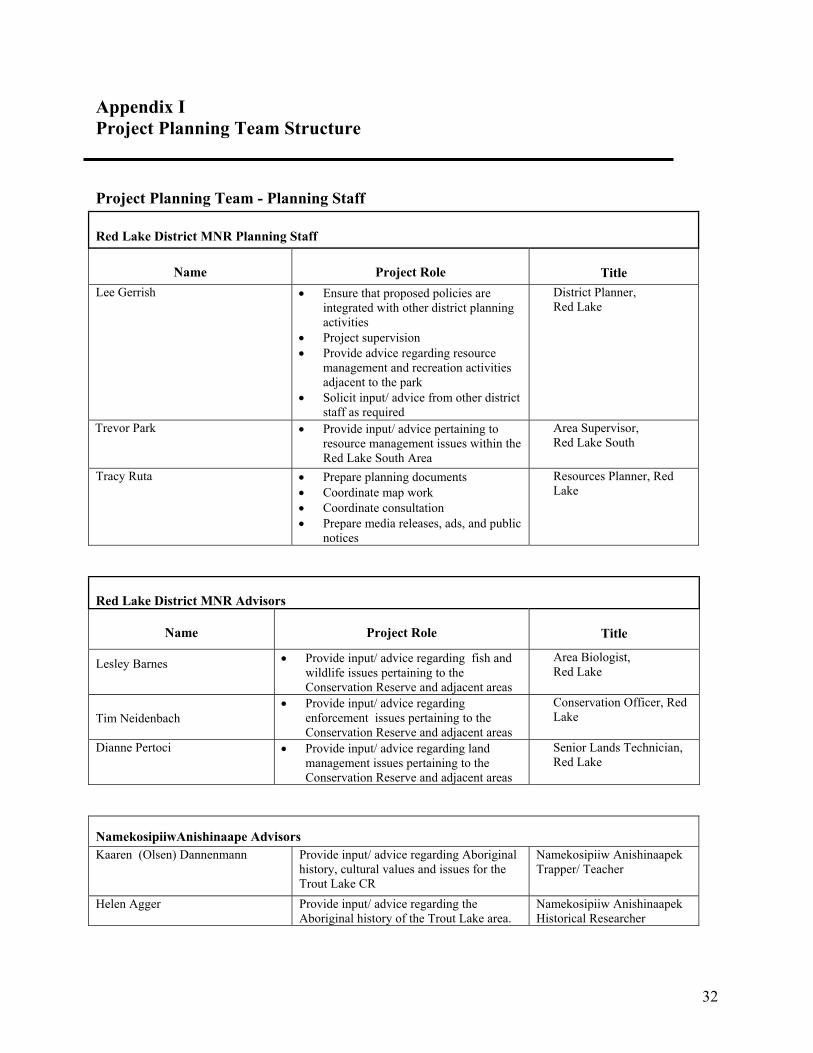
Appendix I Project Planning Team Structure
Project Planning Team - Planning Staff
Red Lake District MNR Planning Staff
Name
Project Role Title Lee Gerrish
• Ensure that proposed policies are
integrated with other district planning activities
• Project supervision • Provide advice regarding resource
management and recreation activities adjacent to the park
• Solicit input/ advice from other district staff as required
District Planner, Red Lake
Trevor Park • Provide input/ advice pertaining to resource management issues within the Red Lake South Area
Area Supervisor, Red Lake South
Tracy Ruta
• Prepare planning documents • Coordinate map work • Coordinate consultation • Prepare media releases, ads, and public
notices
Resources Planner, Red Lake
Red Lake District MNR Advisors
Name
Project Role Title
Lesley Barnes
• Provide input/ advice regarding fish and wildlife issues pertaining to the Conservation Reserve and adjacent areas
Area Biologist, Red Lake
Tim Neidenbach • Provide input/ advice regarding
enforcement issues pertaining to the Conservation Reserve and adjacent areas
Conservation Officer, Red Lake
Dianne Pertoci
• Provide input/ advice regarding land management issues pertaining to the Conservation Reserve and adjacent areas
Senior Lands Technician, Red Lake
NamekosipiiwAnishinaape Advisors Kaaren (Olsen) Dannenmann Provide input/ advice regarding Aboriginal
history, cultural values and issues for the Trout Lake CR
Namekosipiiw Anishinaapek Trapper/ Teacher
Helen Agger Provide input/ advice regarding the Aboriginal history of the Trout Lake area.
Namekosipiiw Anishinaapek Historical Researcher
33
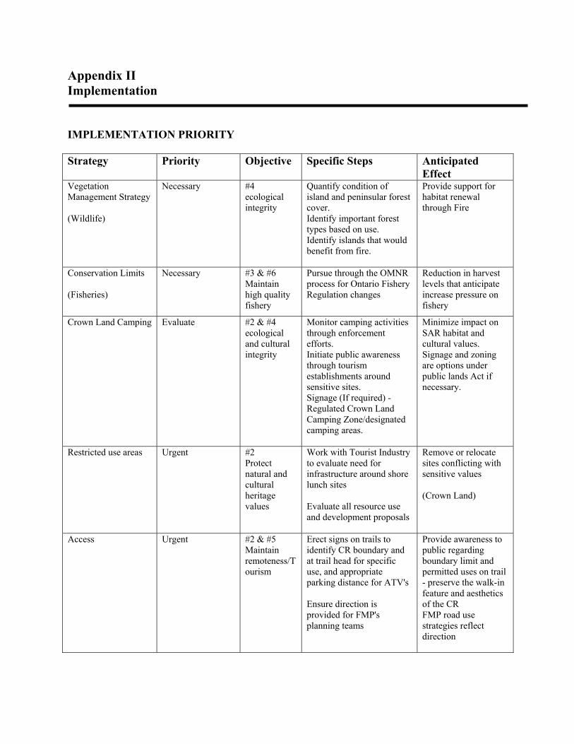
Appendix II Implementation
IMPLEMENTATION PRIORITY Strategy Priority Objective Specific Steps Anticipated
Effect Vegetation Management Strategy (Wildlife)
Necessary #4 ecological integrity
Quantify condition of island and peninsular forest cover. Identify important forest types based on use. Identify islands that would benefit from fire.
Provide support for habitat renewal through Fire
Conservation Limits (Fisheries)
Necessary #3 & #6 Maintain high quality fishery
Pursue through the OMNR process for Ontario Fishery Regulation changes
Reduction in harvest levels that anticipate increase pressure on fishery
Crown Land Camping Evaluate #2 & #4 ecological and cultural integrity
Monitor camping activities through enforcement efforts. Initiate public awareness through tourism establishments around sensitive sites. Signage (If required) - Regulated Crown Land Camping Zone/designated camping areas.
Minimize impact on SAR habitat and cultural values. Signage and zoning are options under public lands Act if necessary.
Restricted use areas Urgent #2 Protect natural and cultural heritage values
Work with Tourist Industry to evaluate need for infrastructure around shore lunch sites Evaluate all resource use and development proposals
Remove or relocate sites conflicting with sensitive values (Crown Land)
Access Urgent #2 & #5 Maintain remoteness/Tourism
Erect signs on trails to identify CR boundary and at trail head for specific use, and appropriate parking distance for ATV's Ensure direction is provided for FMP's planning teams
Provide awareness to public regarding boundary limit and permitted uses on trail - preserve the walk-in feature and aesthetics of the CR FMP road use strategies reflect direction

34
Appendix III Aboriginal History
Namegosibii Anishinaabeg: Our History
submitted by
S. Keesick Olsen, J. Angeconeb, J. Keesick, A. Harper, I. Olsen, H. Agger, Donna Williams, and Kaaren Dannenmann
2004
It is generally known that Anishinaabe people kept oral as opposed to written records of history. What is less known is the fact that the Anishinaabe system has been proven to be highly accurate by scholarly researchers. Moreover, oral history is recognized throughout the Canadian legal system to have equal weight to (written) documentation and is being used successfully to prove legal arguments in court cases. The tradition of oral record keeping was interrupted and almost destroyed by outside forces such as residential schooling (where children were not allowed to speak their native language or practise their culture), but through some individuals who did not attend school our people’s oral history has been retained. The living memory of Namegosibii Anishinaabeg reaches back to Jiiyaan, who was born in Trout Lake and belonged to the Adikodoodem, the Caribou totem. As was the tradition at that time, Jiiyaan had several wives. Kiizhik Sam Keesick was one of his children. Also born and raised in Namegosibiing, Kiizhik grew up and was taught under unusually austere conditions. He was sent to andobawaajige, to seek his life’s vision at a very young age. Kiizhik Sam Keesick and his wife had nine children, all of whom were born and raised in Namegosibiing Trout Lake. Early on, however, they lost one of their sons as well as their only daughter. Kiizhik was a full-time trapper and hunter; he also represented his people as a Band councilor for several years. Over the course of his long life, he became recognized throughout the region -- in both Anishinaabe and non-Anishinaabe communities -- as a wise, compassionate and skillful leader. Indian Affairs paylist records of 1901 indicated the date of birth for each of Kiizhik’s sons to be as follows: Mooniyaans Thomas, 1860; Naadowe Robert, 1870; Kiiweyaas(h)in William Keesick “South Wind,” 1863; Dedibaayaash William Sam Keesick, 1875; Netawibiitam John, 1883; and Jiiyaan Donald, 1877. Jiimis James’s date of birth was not listed. While these dates are not entirely accurate (for example, Netawibiitam John was in fact older than Jiiyaan Donald), they serve to place the lives of these individuals within a historical timeframe. Each of Kiizhik’s sons had several children. While most were born and raised in Namegosibiing Trout Lake, all were born within the Namegosibii Anishinaabe traditional territories. Three of his grandchildren are still with us today. They are George Naataway Keesick (Red Lake), whose father was Naadowe Robert Keesick; Shamaandy Kejick (Kejick Bay, Lac Seul First Nation), whose father was Jiimis James Keesick; and Dedibaayaanimanook Sarah Keesick Olsen (Red Lake), whose father was Dedibaayaash
35
William Sam Keesick. These individuals are the repository for the history of our people; it is the story of their knowledge, memories and lives that is being shared by their children and grandchildren today. Dedibaayaanimanook Sarah Keesick Olsen, for example, was born at Gaaminitgwashkiigaag Keesick Bay, a large bay located within the eastern region of Namegosibiing Trout Lake. After she was born, her mother Gaamadweyaashiik rested in her tent, and as she gazed through a small tear in the canvas she noticed a wispy sliver of silver. Maangogiizhis gii’ oshkagoojin: it was the new moon of the Loon Month. Later, Indian Affairs would record the date to be April 29, 1922. As young children, Dedibaayaanimanook Sarah and her siblings (cousins, in the non-Anishinaabe system) acquired the many skills necessary to live the Anishinaabe way by accompanying their parents as they traveled from place to place to fish, hunt, trap and harvest. Namegosibiing was their home base, but they took their annual madaawa’am canoe trips down Trout (Lake) River to the Obizhigokaang Lac Seul region in the south. Upon their return in early autumn, the Namegosibii Anishinaabeg held a celebratory feast in which they expressed gratitude for the many blessings of their homeland. They spoke of the animals who sacrificed their lives to give them food and provide them with clothing. They thanked Gizhe Manidoo for the standing timbers that made dabinawaa (sheltered) places for them in which to find shelter from stormy weather and for the trees themselves that produced materials for making their homes and keeping them warm. Finally, they requested safety and protection for the coming winter. Dedibaayaanimanook was approximately six years old when her grandfather died. Before his death, however, Kiizhik Sam Keesick shared his many insights. He stated that extremely difficult times lay immediately ahead for them the Anishinaabe people as the old order was increasingly under attack. The people would be reviled and disrespected. A terrible disease would decimate them, and after his death wemitigoozhiwag (non-Anishinaabeg) would enter Namegosibiing. No longer would it be the healthy and peaceful homeland they had known since time immemorial. He encouraged them each to find the path to Minobimaadiziwin, a life of integrity and courage. One day in January 1939, ten or so years after the passing of Kiizhik Sam Keesick, the Angeconeb brothers set out across the lake to investigate why a plane had apparently landed at Ma’iingani Minis, Wolf Island. “Amii’ wii’ giigooyikaadeg gi Namegosibiiminaan.” The people soon learned that wemitigoozhiwag had arrived in Trout Lake, preparing to set up a commercial fishing operation on the lake. At once, Kiizhik Sam Keesick’s prophetic words came to mind: Was this the beginning of the end for life as they the Namegosibii Anishinaabeg had known it to be for as far back as they could remember? Although the fishing business provided employment opportunities for some of the people, it also meant that they were no longer able to take their annual madaawa’am journeys to Lac Seul. Approximately four years after the foreigners’ arrival, Dedibaayaanimanook Sarah Keesick began her life’s journey with the wemitigoozhi in charge. Sarah and Einar Olsen would raise a family of six children in Namegosibiing. John Beck Keesick, born just before freeze-up in Namegosibii Shishiing (Little Trout Lake), is another of Kiizhik’s descendants. As a child, he was fond of accompanying his father Detaginang Frank Keesick on trapping and hunting expeditions throughout Namegosibiing. He remembered that they trapped for
36
beaver, mink, muskrat, and otter and that moose were plentiful throughout the area. Walking from Gaaminitigwashkiigaag (Keesick Bay) to Onamani Zaa’igan (Red Lake) with his brother Johnson and uncle Jiimis James to sell their maanataana’ to the baamadaawe (independent trader) Ken McDougall took them at least one night’s stop, as he recalled. Then John Keesick was sent off to boarding school when he was approximately eight years of age. He remembered that the papers were stamped with the year 1940. Saagaate Josie Angeconeb is a Namegosibii Anishinaabe woman born in Trout Lake during the late 1940s or early 1950s. Her father Chiins Charlie Angeconeb, who was Dedibaayaanimanook’s Sarah Keesick Olsen’s (half) brother, was a skilled outdoorsman who trapped, hunted and fished in Trout Lake. Their trapline extended throughout the northwest section of Namegosibiing. Rather than going out on the family trapline, that being the responsibility of her brothers Charlie and Simon, Saagaate helped with household chores that included getting water whenever “my mom could get us going.” She and her sisters learned how to sew doll clothes and when they played outdoors they amused themselves with making snowmen and other activities. Saagaate remembers family outings to visit with others in Namegosibiing. They went to see their aunt Gweyesh Annie Angeconeb, Gweyesh’s daughter Bejii Betsy King, the Detaginang Frank Keesicks and Soons and Alice Oojiiwasawaan. While the adults caught up on the latest news, the children played games together. During the 1950s and 1960s, provincial government officials began to make living in Namegosibiing difficult. The Anishinaabe people were pushed from their natural and treaty recognized birthright, their traditional homelands. As a consequence there are people to this day who do not feel safe in taking part in joint projects with the Ministry of Natural Resources. They are of the opinion that whatever they say will be used against them in some way. At that same time, Aboriginal peoples across the nation began to organize politically in order to have their rights recognized and upheld. The Canadian Constitution of 1982 has affirmed our Treaty and Aboriginal rights, and governments are no longer as easily able to make laws that undermine those rights. Our people’s orally preserved history largely substantiates the written records that refer to our forebears. As the Hudson’s Bay Company, Christian churches and later Canada’s Department of Indian Affairs became major influences in the lives of the Anishinaabe people, HBC archival records, church data and Indian Affair annual reports provided information that traces to the nineteenth century. The Company’s archival material dating back some 175 years mentioned individuals whose connection to the Namegosibii Anishinaabeg is not absolutely established. Nonetheless, Geean, Keweykejick, Show on ee Kijick, Kijick O, Nai Now e Kijick Waish Kung and other similar names carry a familiar ring with the Keesicks and Kejicks of today. They were some of the trappers who once traded with the HBC at the Lac Seul post. By the latter nineteenth century, specific references to Namegosibii Anishinaabeg started to appear in HBCompany records. In fact, the Company set up an outpost in Trout Lake for the purpose of carrying out trade with the Anishinaabe trappers of the region. It was described as a two days’ canoe journey up the Trout River from Mattawa (Maadaawaang). Today, we refer to a large peninsula in Trout Lake as Getewaakaa’iganing [The Place of The Old Building], and an accurate map will show the location to be Hudson’s Bay Point. Archivists recently compiled a list of Company men associated with the outpost.
37
Written records begin to merge with the Anishinaabe oral history when people such as the Keesick brothers where children. For example, Dedibaayaanimanook’s father, Dedibaayaash William (“Bill”) Sam Keesick, mentioned having known John Moar, the Trout Lake outpost manager for the HBC from 1879 to 1882. As well, Namegosibii Anishinaabeg got on well with a post manager known as Jim. Among the Trout Lake people, he was referred to as Mangimisad [Large Abdomen], and his son was Mangimisadens [Little Mangimisad]. Mangimisad may well have been James W. Anderson, the outpost manager in Trout Lake during the year 1890 - 1891. The Lac Seul Anishinaabeg, of whom the Trout Lake people are a part, signed their adhesion to historic Treaty #3 on June 9, 1874. In exchange for ceding 55,000 square miles of land to the Dominion, our people received annual payments in the form of some cash and material goods for which they assembled at Treaty Point in Lac Seul during Diba’amaadim (Treaty Time). Indian agents began to keep treaty annuity paylists for annual reports in which the names of Namegosibii Anishinaabeg may still be found. The treaty terms stated that Anishinaabe people were to retain their “ ... right to pursue their avocations of hunting and fishing throughout the tract surrendered ... ”. Today as in the past, Trout Lake and adjacent areas -- in all directions -- including the ancient canoe route from Namegosibii Shishiing (Little Trout Lake) all the way to Obizhigokaawi Zaa’igan (Lac Seul Lake) continue to be our traditional territories. We, the Namekosipiiw Anishinaapek, acknowledge and honour our teachers: The creator, the earth, water, air, life and all our relations: our mothers, fathers, brothers, sisters, aunts, uncles, cousins, nieces, nephews, our children, and our grandparents, all the NamekosipiiwAnishinaape of the past, present and future, and especially, our First Teacher, Trout Lake.
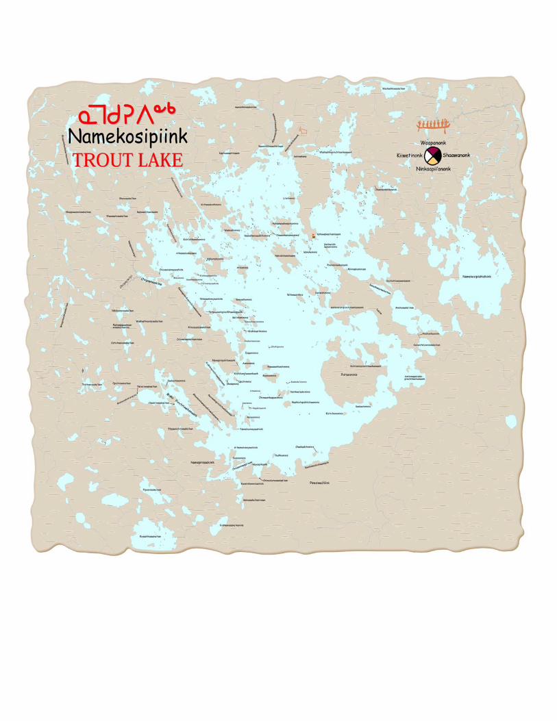
38
39
Appendix IV Aboriginal Use of Fire
Submitted by Kaaren Dannenmann 2005
In the past, Trout Lake was a landscape whose significant characteristics were kept in balance by the cultural practices of its human community, the NamekosipiiwAnishinaapek. The question needs to asked, how did the Trout Lake Anishinaapek belong to its ecosystem? What were their social and ecological relations that worked to stabilize their physical environment? It is necessary to look at how environment initially shapes the way that a people live and how that culture then reshapes that environment in response to the initial choices made available by that environment. Mutual determination, that is, reciprocity between land and man, was thus set up and reinforced by their belief system and day-to-day practices. Every day ceremonial activities reflect the interaction between Trout Lake and its people, the mutual caring and providing for, the mutual respect and responsibility. Population density was affected by the availability of food. (Biological populations are limited by the minimum amount of food that can be found in the scarcest times of the year -- “Liebig’s Law”). “By keeping population densities low, the food scarcities of winter guaranteed the abundance of spring, and contributed to the overall stability of human relationships to the ecosystem.” (Changes in the Land, by William Cronon) Trout Lake Anishinaapek obtained their food wherever it was seasonally available in the Trout Lake area, e.g., at “Wolf Island” in the autumn to harvest whitefish and trout, or at ChiipayiSaakiink in the spring, where muskrat, beaver and migrating water fowl were plentiful in the creeks and streams that flowed from further inland. Every season had its bounty and/or scarcity and this required an intimate understanding of the habits and ecology of all life species on the lake. The Trout Lake Anishinaapek had well-developed economic and social and kinship systems as well as cultural beliefs and practices that had a complexity that accounted for all this. For example, mobility, their seasonal migrations, was another way of making the most of the seasonal diversity obtainable around Trout Lake. Their groupings constantly shifted, in size and location, breaking up and re-assembling as their economic, social and cultural needs required. Each year, they returned to a different place on Trout Lake, often only 100 feet down the shoreline from the previous year. Practical reasons dictated this practice. The forest around Trout Lake, as well as its island cover, was primarily shaped by its human inhabitants and their tools. Fire was a tool for developing island habitat for blueberries or raspberries, or shoreline habitat for muskrat and beaver, and their knowledge in its use was comprehensive and exact. They were able to create ground fires of various intensities and were able to determine the exact time frame to carry out this work. These time frames were often tiny windows of opportunity only during specific seasons. We are often asked how, historically, we protected ourselves from forest fires. It is important to note that, in order to understand this, one must ask the right questions. Our practices were not so

40
much to protect ourselves from devastating forest fires, but for the practical needs of every day life, which, in turn, afforded us protection from large-scale forest fires. Our practice was to use only dead forest material for fuel for our campfires, and young women and children did this work. They collected materials on the ground and from trees around the camp. As time went on, they moved further and further from the campsite to collect the branches and logs to burn. For this reason, they did not return to the same campsites year after year. In this way, too, they kept their environment “groomed” and protected from large forest fires. Since the disruptions of industrial and tourist development on the lives of the NamekosipiiwAnishinaapek, the forest cover around Trout Lake and on its islands have changed dramatically. Infestations of spruce budworm (a species not indigenous to this continent) have also drastically affected the islands of Trout Lake, killing much of the forest cover on the islands which have succeeded to a habitat type of downed balsam fir and the resultant overgrowth of certain plants such as raspberry shrubs. The islands are now extremely difficult to walk through and their suitability for caribou and moose habitat is questionable. Periodic fires are necessary to renew forest habitat as it changes species composition and structure. Fire suppression is now seen as having been so effective that in some areas, such as the islands of Trout Lake, the natural role of fire has not been allowed to play out. The islands have not been burned for long periods and would probably benefit from fire to renew habitat, eventually bringing back a mature, relatively open, even-aged jack pine or black spruce forest. It is important to note that some of the islands are located centrally on Trout Lake (a large water-body) and that it may be a natural occurrence that a fire burning on the shoreline may not normally spread to these islands. Another consideration is that islands in this late stage of succession may provide important habitat for other species such as wolverine and nesting birds. Further study and research has to take place and this must occur within the parameters of a partnership, or at least within a mutually-beneficial working relationship, between the NamekosipiiwAnishinaapek and the MNR. It may be imperative to encourage Anishinaapek to return to Trout Lake and regain their rightful place in its ecology, by re-developing a way of living on the lake that will re-establish the ancient relationships of mutuality and balance between land and man.
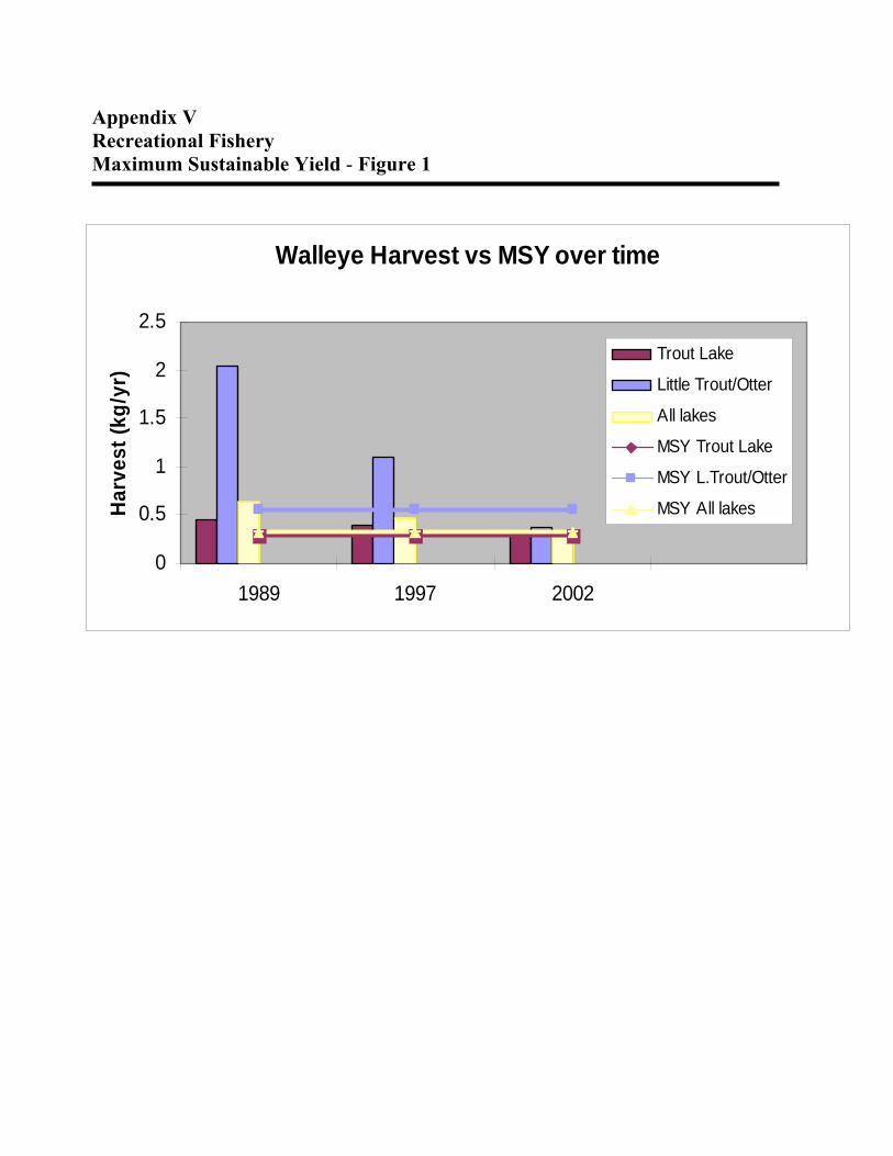
41
Appendix V Recreational Fishery Maximum Sustainable Yield - Figure 1
Walleye Harvest vs MSY over time
0
0.5
1
1.5
2
2.5
1989 1997 2002
Harv
est (
kg/y
r)
Trout Lake
Little Trout/Otter
All lakes
MSY Trout Lake
MSY L.Trout/Otter
MSY All lakes
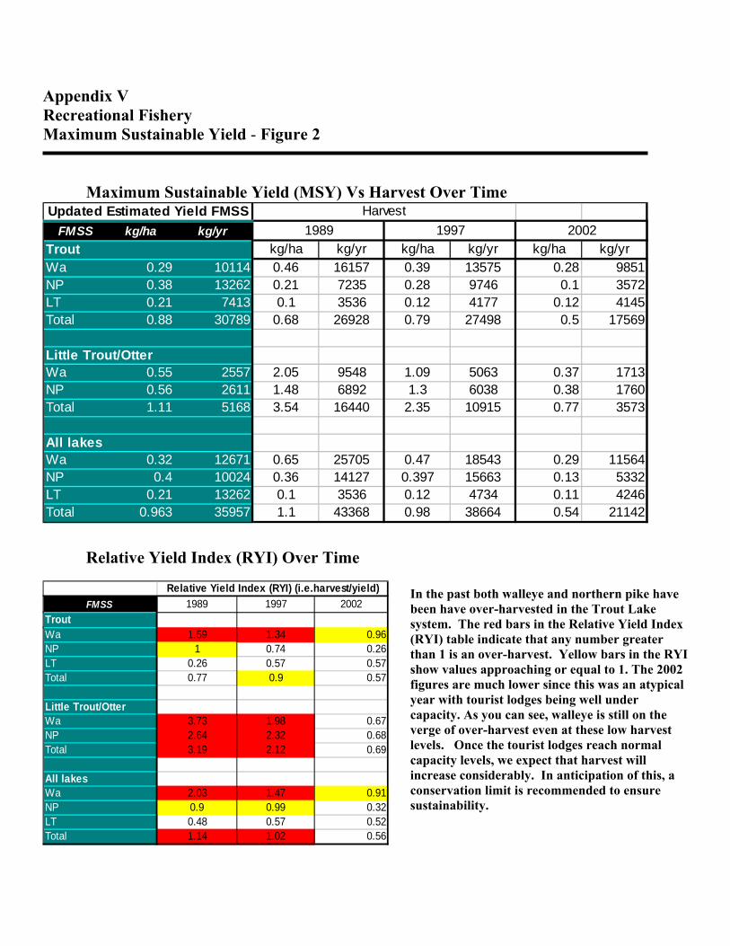
42
Appendix V Recreational Fishery Maximum Sustainable Yield - Figure 2
Maximum Sustainable Yield (MSY) Vs Harvest Over Time
Relative Yield Index (RYI) Over Time
In the past both walleye and northern pike have been have over-harvested in the Trout Lake system. The red bars in the Relative Yield Index (RYI) table indicate that any number greater than 1 is an over-harvest. Yellow bars in the RYI show values approaching or equal to 1. The 2002 figures are much lower since this was an atypical year with tourist lodges being well under capacity. As you can see, walleye is still on the verge of over-harvest even at these low harvest levels. Once the tourist lodges reach normal capacity levels, we expect that harvest will increase considerably. In anticipation of this, a conservation limit is recommended to ensure sustainability.
Updated Estimated Yield FMSS HarvestFMSS kg/ha kg/yr
Trout kg/ha kg/yr kg/ha kg/yr kg/ha kg/yrWa 0.29 10114 0.46 16157 0.39 13575 0.28 9851NP 0.38 13262 0.21 7235 0.28 9746 0.1 3572LT 0.21 7413 0.1 3536 0.12 4177 0.12 4145Total 0.88 30789 0.68 26928 0.79 27498 0.5 17569
Little Trout/OtterWa 0.55 2557 2.05 9548 1.09 5063 0.37 1713NP 0.56 2611 1.48 6892 1.3 6038 0.38 1760Total 1.11 5168 3.54 16440 2.35 10915 0.77 3573
All lakesWa 0.32 12671 0.65 25705 0.47 18543 0.29 11564NP 0.4 10024 0.36 14127 0.397 15663 0.13 5332LT 0.21 13262 0.1 3536 0.12 4734 0.11 4246Total 0.963 35957 1.1 43368 0.98 38664 0.54 21142
1989 1997 2002
FMSS 1989 1997 2002TroutWa 1.59 1.34 0.96NP 1 0.74 0.26LT 0.26 0.57 0.57Total 0.77 0.9 0.57
Little Trout/OtterWa 3.73 1.98 0.67NP 2.64 2.32 0.68Total 3.19 2.12 0.69
All lakesWa 2.03 1.47 0.91NP 0.9 0.99 0.32LT 0.48 0.57 0.52Total 1.14 1.02 0.56
Relative Yield Index (RYI) (i.e.harvest/yield)

43
Appendix VI Earth and Life Science Report
C2334 Trout Lake Conservation Reserve
NATURAL HERITAGE AREA – LIFE SCIENCE CHECKSHEET Name C2334 Trout Lake
Map Name Little Trout Lake, Trout Lake, Nungesser River Henfrey Lake
Map Number 52N/03, 52N/04 52N/05, 52N/06
UTM Ref. Zone 15 480000 E 5670000 N
District Kenora
Lat. 51° 15‘ N
Long. 93° 15‘ W
NAD 83
Min. Alt. 380 m
Max. Alt. 470 m
Locality Approx. 30 km NE of Red lake
Township unorganized
Area 60,082 ha
Ownership Crown
MNR Region Northwest
Ecoregion and Ecodistrict 3S-2
Landform Unit See Table 4
MNR District Red Lake
#
Red Lake
Physical and Biological Features The Trout Lake Conservation Reserve includes Trout, Otter and Little Trout lakes, islands and associated shorelines. The Trout Lake Provincial Nature Reserve forms most of the western boundary of the Conservation Reserve. The Trout Lake Conservation Reserve is primarily, weakly to moderately broken relief, with the exception of steep terrain along the Trout Lake Moraine to the west of the Conservation Reserve. Trout Lake is a large (34,807 ha), clear, oligotrophic lake with a morphoedaphic index (MEI) of 3.3. The lake is relatively shallow (mean depth 17.3 m), and approximately 27% is littoral zone (<6 m depth). Maximum depth is 47 m. A diverse fish community is dominated by lake trout, lake whitefish, lake herring, northern pike, and white sucker. Little Trout Lake (3521 ha) and Otter Lake (946 ha) have relatively similar characteristics and are located downstream, discharging southeast through the Trout Lake River. In addition, Sidace and Bathurst creeks and numerous smaller tributaries flow into Trout Lake.
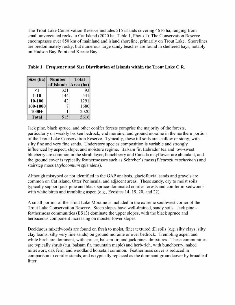
44
The Trout Lake Conservation Reserve includes 515 islands covering 4616 ha, ranging from small unvegetated rocks to Cat Island (2020 ha, Table 1, Photo 1). The Conservation Reserve encompasses over 850 km of mainland and island shoreline, primarily on Trout Lake. Shorelines are predominately rocky, but numerous large sandy beaches are found in sheltered bays, notably on Hudson Bay Point and Keesic Bay.
Table 1. Frequency and Size Distribution of Islands within the Trout Lake C.R. Size (ha) Number
of Islands Total
Area (ha) <1 321 93
1-10 144 531 10-100 42 1291
100-1000 7 1680 1000+ 1 2020 Total 515 5616
Jack pine, black spruce, and other conifer forests comprise the majority of the forests, particularly on weakly broken bedrock, end moraine, and ground moraine in the northern portion of the Trout Lake Conservation Reserve. Typically, these till soils are shallow or stony, with silty fine and very fine sands. Understory species composition is variable and strongly influenced by aspect, slope, and moisture regime. Balsam fir, Labrador tea and low-sweet blueberry are common in the shrub layer, bunchberry and Canada mayflower are abundant, and the ground cover is typically feathermosses such as Schreber’s moss (Pleurozium schreberi) and stairstep moss (Hylocomium splendens). Although mistyped or not identified in the GAP analysis, glaciofluvial sands and gravels are common on Cat Island, Otter Peninsula, and adjacent areas. These sandy, dry to moist soils typically support jack pine and black spruce-dominated conifer forests and conifer mixedwoods with white birch and trembling aspen (e.g., Ecosites 14, 19, 20, and 22). A small portion of the Trout Lake Moraine is included in the extreme southwest corner of the Trout Lake Conservation Reserve. Steep slopes have well-drained, sandy soils. Jack pine - feathermoss communities (ES13) dominate the upper slopes, with the black spruce and herbaceous component increasing on moister lower slopes. Deciduous mixedwoods are found on fresh to moist, finer textured till soils (e.g. silty clays, silty clay loams, silty very fine sands) on ground moraine or over bedrock. Trembling aspen and white birch are dominant, with spruce, balsam fir, and jack pine admixtures. These communities are typically shrub (e.g. balsam fir, mountain maple) and herb-rich, with bunchberry, naked mitrewort, oak fern, and woodland horsetail common. Feathermoss cover is reduced in comparison to conifer stands, and is typically replaced as the dominant groundcover by broadleaf litter.
45
Large areas of treed wetlands are located on ground moraine west of Otter Lake and Little Trout Lake at the base of the Trout Lake Moraine, and along Bathhurst Creek. Black spruce dominated semi-treed and treed bogs (ES34) are located in the centre of these wetlands, where fibric and mesic peats are typically greater than 1.2 m in depth. Tamarack treed poor fens (ES40) and poor (ES35) to intermediate (ES36) black spruce swamps dominate around the margins and where shallow peat overlies saturated tills. Labrador tea, cloudberry, and other ericaceous shrubs are common; Sphagnum cover is extensive, with increasing feathermoss over shallower peat. The Trout Lake Conservation Reserve encompasses at least 1000 ha of burn on bedrock and ground moraine, including critical representation for three LV-types. Post-burn regeneration is typically dominated by jack pine, fireweed, horseweed, bristly sarsaparilla, Houghton’s sedge, and the liverwort Marchantia polymorpha. There is a broad range of non-forested wetlands in the Trout Lake Conservation Reserve. Scirpus and Phragmites marshes are common in higher wave-energy environments on mineral substrate along the Little Trout River and Otter Lake. Rich open-water marshes with a sedimentary peat substrate are found in sheltered bays (e.g., near Bathhurst Creek) and are dominated by submergents such as water milfoil, Canada waterweed, and pondweeds. A significant wild rice marsh is found in Jackfish Bay. Leatherleaf-dominated low shrub shore fens (W15) grade to wire sedge-dominated shore fens (W14) along quiet shorelines and watercourses.
Representation The Trout Lake Conservation Reserve contains at least 43 LV-types, of which 24 are considered representative of the site district (Table 4). The conservation reserve is considered critical for 3S-2 representation of eight LV-types. Twenty-two additional LV-types, primarily on lacustrine and organic deposits, may also have small areas represented in the conservation reserve. In particular, the Trout Lake Conservation Reserve provides good representation of conifer forests on a range of landforms. There are some inconsistencies between Ministry of Natural Resources data sets and field results, which may be partially accounted for by differences in mapping and scale. For example, on the basis of field reconnaissance, 2835 ha of the Trout Lake Conservation Reserve were mapped as glaciolacustrine deposits. Spatial LV-type data provided by Ministry of Natural Resources did not show any glaciolacustrine deposits; however, other, non-spatial Ministry of Natural Resources data lists 1375 ha of lacustrine deposit in the conservation reserve that represents eight LV-types. One of these, burn on lacustrine deposit, was considered critical for representation in 3S-2. The discrepancy may be at least partially due to missing spatial LV data for islands within the conservation reserve. A combination of fire history and field reconnaissance data indicates that there are actually 653 ha of burn on glaciolacustrine deposits in the conservation reserve. Similar discrepancies between spatial and other Ministry of Natural Resources data were observed for other LV-types on glaciolacustrine and organic deposits in particular. The majority of the bedrock LV-types are found in the in the northwest corner of the Trout Lake Conservation Reserve. NOEGTS maps and aerial photograph interpretation suggest that at least
46
some of this area should be classified as ground moraine since till deposits overlying the bedrock are greater than 1 m in some areas. Unfortunately, field confirmation could not be conducted due to time constraints. The potential representation of the Trout Lake Conservation Reserve is misleading since approximately 2/3 is water and does represent aquatic habitats. The Conservation Reserve designation of the waters will allow a greater degree of management control, such as prohibiting mineral extraction from the lake bottom.
Condition The islands and mainland of the Trout Lake Conservation Reserve remain largely undeveloped and pristine due to lack of direct road access. This is exceptional for a lake this size given its proximity to the community of Red Lake. Forest access roads terminate just within the conservation reserve boundary north and south of the Trout Lake Provincial Reserve but do not access the lake. Trout Lake is a significant recreational lake for remote tourism, particularly for recreational lake trout and northern pike fisheries. There are four commercial lodge establishments and one private camp located on Trout Lake, as well as a minimum of five private or commercial boat caches. A canoe route passes from the Anderson Lake system through Trout Lake to the Trout Lake River system. There is significant Anishinaapek use of the Trout Lake Conservation Reserve, including fishing, hunting, and wild rice gathering. There are no recent forestry operations on the islands of the Trout Lake Conservation Reserve, however, there is visible timber harvesting along some mainland shorelines, particularly in the east near Joyce Lake. Several small mining patents exist in the northwest corner of the conservation reserve. There are a large number of bear management areas that overlap the Trout Lake Conservation Reserve boundaries. Few bears, if any, are actually harvested annually from the conservation reserve. Trapping occurs on a number of traplines (or portions thereof) which include the Trout Lake Conservation Reserve, with marten and beaver the main species taken. At least four trapper’s cabins are located in the conservation reserve under the authority of a trapping licence. Due to its configuration i.e., a generally narrow strip of land surrounding Trout, Otter, and Little Trout lakes, the Trout Lake Conservation Reserve is vulnerable to edge effects and lacks the core area to sustain area-sensitive terrestrial species. Activities and disturbance in the surrounding landscape will greatly impact the value of the conservation reserve for larger mammals, particularly woodland caribou and wolverine.
Diversity The Trout Lake Conservation Reserve contains a good diversity of terrestrial and aquatic environments. There is a wide range of weakly and moderately broken surficial geology that includes bedrock, end and ground moraines, glaciofluvial, glaciolacustrine, and organic deposits.
47
In contrast to the diversity of enduring features, the majority of the forest in the conservation reserve is conifer-dominated which, at this latitude, is strongly boreal in character and not particularly species-rich. Conversely, the tributaries, waters, wetlands, and riparian areas of Trout, Otter, and Little Trout lakes contribute significantly to the diversity of habitats, communities, and species in the conservation reserve.
Ecological Considerations The waters of Trout, Otter, and Little Trout lakes have a profound influence on and very strong ecological links with the terrestrial habitats and species of the Trout Lake Conservation Reserve. The fish communities of these lakes help support piscivorous birds such as bald eagle, red-necked grebe, and the common loon as well as river otter and mink. Localized wetlands provide habitat and aquatic feeding areas for beaver, muskrat, and moose. The lake also provides isolation from predators and disturbance for caribou and moose calving. Wildfires burned mainland portions of the Trout Lake Conservation Reserve during the 1930s, 1960s, 1970s, and 1990s. There was little evidence of fire on the islands due to the barrier effect of the lake. A long fire interval and the absence of harvesting has resulted in mature to over-mature stands on the islands. As standing dead topple over and the overstory of these stands breaks up, shade-tolerant mountain maple and balsam fir are released and create a dense shrubs understory. During the early 1990s, much of the Trout Lake Conservation Reserve experienced moderate to high spruce budworm-induced mortality of balsam fir and, to a lesser extent, white spruce. Since the mid-1990s, moderate defoliation from spruce budworm has continued. Localized Windthrow is common throughout the Conservation Reserve, particularly on west-facing shores of islands having overmatured forests with high spruce budworm mortality. Double-crested cormorants appear to be recent arrivals on Trout Lake and their numbers may be expanding.
Special Features An adult and a juvenile red-necked grebe (S3B) were observed during fieldwork in a marsh at the mouth of Bathurst Creek, confirming breeding of this rare species (S3B) in the Trout Lake Conservation Reserve. They have been recorded breeding of red-necked grebes at the Cochenour Ponds, approximately 30 km west of Trout Lake. There are very few (<10) confirmed breeding locations for this species in northwestern Ontario. Woodland caribou, considered vulnerable by COSSARO (S3S4), use some of the islands of the Conservation Reserve for calving. The islands of Trout Lake are considered a regionally significant caribou calving area since they are used by a large number of animals from a large surrounding range. During fieldwork, woodland caribou trails, pellets, and past cratering were observed on mainland points and islands.
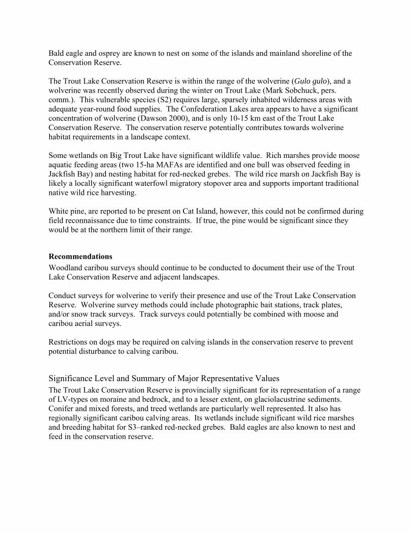
48
Bald eagle and osprey are known to nest on some of the islands and mainland shoreline of the Conservation Reserve. The Trout Lake Conservation Reserve is within the range of the wolverine (Gulo gulo), and a wolverine was recently observed during the winter on Trout Lake (Mark Sobchuck, pers. comm.). This vulnerable species (S2) requires large, sparsely inhabited wilderness areas with adequate year-round food supplies. The Confederation Lakes area appears to have a significant concentration of wolverine (Dawson 2000), and is only 10-15 km east of the Trout Lake Conservation Reserve. The conservation reserve potentially contributes towards wolverine habitat requirements in a landscape context. Some wetlands on Big Trout Lake have significant wildlife value. Rich marshes provide moose aquatic feeding areas (two 15-ha MAFAs are identified and one bull was observed feeding in Jackfish Bay) and nesting habitat for red-necked grebes. The wild rice marsh on Jackfish Bay is likely a locally significant waterfowl migratory stopover area and supports important traditional native wild rice harvesting. White pine, are reported to be present on Cat Island, however, this could not be confirmed during field reconnaissance due to time constraints. If true, the pine would be significant since they would be at the northern limit of their range.
Recommendations Woodland caribou surveys should continue to be conducted to document their use of the Trout Lake Conservation Reserve and adjacent landscapes. Conduct surveys for wolverine to verify their presence and use of the Trout Lake Conservation Reserve. Wolverine survey methods could include photographic bait stations, track plates, and/or snow track surveys. Track surveys could potentially be combined with moose and caribou aerial surveys. Restrictions on dogs may be required on calving islands in the conservation reserve to prevent potential disturbance to calving caribou.
Significance Level and Summary of Major Representative Values The Trout Lake Conservation Reserve is provincially significant for its representation of a range of LV-types on moraine and bedrock, and to a lesser extent, on glaciolacustrine sediments. Conifer and mixed forests, and treed wetlands are particularly well represented. It also has regionally significant caribou calving areas. Its wetlands include significant wild rice marshes and breeding habitat for S3–ranked red-necked grebes. Bald eagles are also known to nest and feed in the conservation reserve.
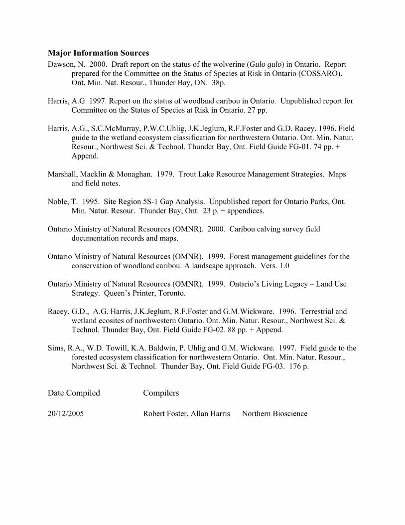
49
Major Information Sources Dawson, N. 2000. Draft report on the status of the wolverine (Gulo gulo) in Ontario. Report
prepared for the Committee on the Status of Species at Risk in Ontario (COSSARO). Ont. Min. Nat. Resour., Thunder Bay, ON. 38p.
Harris, A.G. 1997. Report on the status of woodland caribou in Ontario. Unpublished report for
Committee on the Status of Species at Risk in Ontario. 27 pp. Harris, A.G., S.C.McMurray, P.W.C.Uhlig, J.K.Jeglum, R.F.Foster and G.D. Racey. 1996. Field
guide to the wetland ecosystem classification for northwestern Ontario. Ont. Min. Natur. Resour., Northwest Sci. & Technol. Thunder Bay, Ont. Field Guide FG-01. 74 pp. + Append.
Marshall, Macklin & Monaghan. 1979. Trout Lake Resource Management Strategies. Maps
and field notes. Noble, T. 1995. Site Region 5S-1 Gap Analysis. Unpublished report for Ontario Parks, Ont.
Min. Natur. Resour. Thunder Bay, Ont. 23 p. + appendices. Ontario Ministry of Natural Resources (OMNR). 2000. Caribou calving survey field
documentation records and maps. Ontario Ministry of Natural Resources (OMNR). 1999. Forest management guidelines for the
conservation of woodland caribou: A landscape approach. Vers. 1.0 Ontario Ministry of Natural Resources (OMNR). 1999. Ontario’s Living Legacy – Land Use
Strategy. Queen’s Printer, Toronto. Racey, G.D., A.G. Harris, J.K.Jeglum, R.F.Foster and G.M.Wickware. 1996. Terrestrial and
wetland ecosites of northwestern Ontario. Ont. Min. Natur. Resour., Northwest Sci. & Technol. Thunder Bay, Ont. Field Guide FG-02. 88 pp. + Append.
Sims, R.A., W.D. Towill, K.A. Baldwin, P. Uhlig and G.M. Wickware. 1997. Field guide to the
forested ecosystem classification for northwestern Ontario. Ont. Min. Natur. Resour., Northwest Sci. & Technol. Thunder Bay, Ont. Field Guide FG-03. 176 p.
Date Compiled Compilers 20/12/2005 Robert Foster, Allan Harris Northern Bioscience
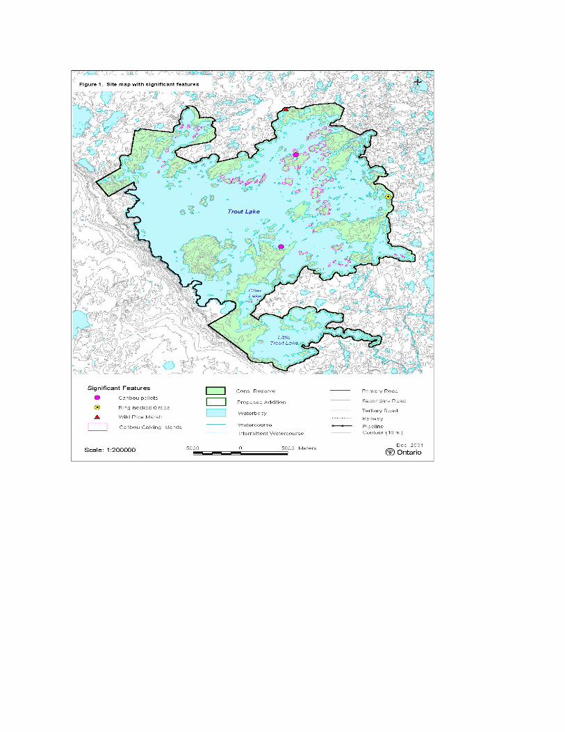
50
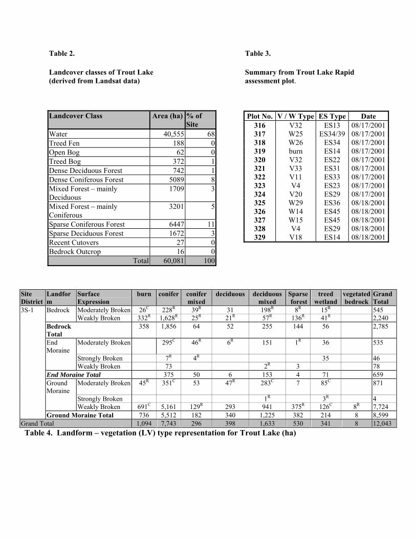
51
Table 2. Table 3.
Landcover classes of Trout Lake Summary from Trout Lake Rapid (derived from Landsat data) assessment plot.
Table 4. Landform – vegetation (LV) type representation for Trout Lake (ha)
Plot No. V / W Type ES Type Date 316 V32 ES13 08/17/2001317 W25 ES34/39 08/17/2001318 W26 ES34 08/17/2001319 burn ES14 08/17/2001320 V32 ES22 08/17/2001321 V33 ES31 08/17/2001322 V11 ES33 08/17/2001323 V4 ES23 08/17/2001324 V20 ES29 08/17/2001325 W29 ES36 08/18/2001326 W14 ES45 08/18/2001327 W15 ES45 08/18/2001328 V4 ES29 08/18/2001329 V18 ES14 08/18/2001
Landcover Class Area (ha) % of Site
Water 40,555 68Treed Fen 188 0Open Bog 62 0Treed Bog 372 1Dense Deciduous Forest 742 1Dense Coniferous Forest 5089 8Mixed Forest – mainly Deciduous
1709 3
Mixed Forest – mainly Coniferous
3201 5
Sparse Coniferous Forest 6447 11Sparse Deciduous Forest 1672 3Recent Cutovers 27 0Bedrock Outcrop 16 0
Total 60,081 100
Site District
Landform
Surface Expression
burn conifer conifer mixed
deciduous deciduous mixed
Sparse forest
treed wetland
vegetated bedrock
Grand Total
3S-1 Bedrock Moderately Broken 26C 228R 39R 31 198R 8R 15R 545 Weakly Broken 332R 1,628R 25R 21R 57R 136R 41R 2,240 Bedrock Total
358 1,856 64 52 255 144 56 2,785
End Moraine
Moderately Broken 295C 46R 6R 151 1R 36 535
Strongly Broken 7R 4R 35 46 Weakly Broken 73 2R 3 78 End Moraine Total 375 50 6 153 4 71 659 Ground Moraine
Moderately Broken 45R 351C 53 47R 283C 7 85C 871
Strongly Broken 1R 3R 4 Weakly Broken 691C 5,161 129R 293 941 375R 126C 8R 7,724 Ground Moraine Total 736 5,512 182 340 1,225 382 214 8 8,599
Grand Total 1,094 7,743 296 398 1,633 530 341 8 12,043
52
Earth Science Check Sheet DETAILED INFORMATION FOR SITE 2334 TROUT LAKE CONSERVATION RESERVE
PROTECTION HISTORY The Trout Lake Conservation Reserve was identified under the provincial Lands for Life - Ontario's Living Legacy program. The conservation reserve adjoins previously regulated Trout Lake Provincial Nature Reserve, which protects a major portion of the Lac Seul moraine. The Trout Lake Conservation Reserve was principally identified for its life science representation, and recreation and tourism values.
SETTING The Trout Lake Conservation Reserve incorporates all the islands and shorelines of Trout Lake and Little Trout Lake, excluding two commercial tourist lodges. Setbacks from the lake are increased on some of the larger peninsulas, to the extent of including the whole peninsula. Such is the case on the Otter Peninsula and the peninsula of Hudson's Bay Point. The conservation reserve comprises 60 082 hectares of Crown land located in the Red Lake MNR District. Elevations range from 392 m a.s.l., the level of Little Trout Lake, to 473 m a.s.l. on Cat Island.
EARTH SCIENCE FEATURES
Bedrock Geology The Trout Lake Conservation Reserve lies wholly within the Archean age Uchi subprovince. Outcrop density is on the order of 5%, and typically at lake level. The conservation reserve is underlain almost entirely by granitic rocks of the Trout Lake batholith (Stott and Corfu 1991, p.181), and includes its central part. Mapping by Stone and Crawford (1994a, b) has shown the batholith within the conservation reserve to be comprised of a number of contrasting phases. The dominant phase is a suite of foliated rocks ranging from granodiorite to tonalite in composition, in which biotite is the ferromagnesian mineral component. This phase occurs on the central and eastern parts of the Trout Lake and at Little Trout Lake. A variety of the phase in which hornblende is an additional ferromagnesian mineral underlies Otter Lake (station 1-3). A more potassic phase is comprised of massive granodiorite to granite. The massive nature of the rock imparts a typical rounded weathering to outcrops of these rocks. It forms the Cat Island pluton in the west central part of the conservation reserve, the eastern half of which is included in the conservation reserve. It also forms the Primok stock, a small part of which outcrops on the south shore of Little Trout Lake, and a number of smaller unnamed intrusions at the northeast end of Little Trout Lake, at Caskie Bay in the northwest and at Bear Trap Bay (local name) in the northeast (station 2-7). Various gneissic rocks have been mapped at a number of localities (e.g. station 2-2). Lastly, a very minor dioritic phase
53
has been mapped at the mouth of Caskie Bay, but was not visited during the present inventory. Mafic to felsic metavolcanic rocks of the Red Lake greenstone belt underlie a small area within the Reserve at Blackbear Lake (Atkinson and Stone 1993), but were not visited during the present inventory. Exploration for gold has been conducted in that area, presently a Forest Reserve, in recent years (Rubicon Minerals Corporation 2000-2001; Dome Exploration Canada Limited, 1978-1979: Assessment Files, Resident Geologist Office, Red Lake). Surficial Geology Glacial stony sand to sandy silt till (e.g. station 1-4: photo 6) of probable Late Wisconsinan age underlies the northern and southern portions of the Reserve (Sharpe and Russell 1994; Prest 1981). Only a small portion of the Lac Seul (or Trout Lake) Moraine lies in the Reserve, at the southwest end of the previously regulated Trout Lake Provincial Nature Reserve (photo 7). Glaciofluvial sands, comprising a prominent esker, occupy much of Cat Island, the Otter Peninsula (station 1-3: photo 8) and the peninsula of Hudson's Bay Point. Sands and gravels in the middle of the Cat Island have been identified as glaciolacustrine (Sharpe and Russell 1994). Glaciolacustrine clays occur in the vicinity of Otter and Little Trout lakes. The erosive effect of glaciation is evident in a number of whale back ridges (station 2-6: photo 9) and roche moutonnee. Glacial striations, although present, are not prevalent, but indicate movement of ice toward the southwest (215°, 255°, 250°, 220°, 220°, 220°, 225° measured at 7 stations). Wave action of probable Pleistocene and Recent age is evident in boulder beaches on numerous islands in Trout Lake (e.g. station 2-5: photo 10; station 2-12; station 2-14). Numerous sand beaches of Recent age are being constructed around Trout Lake (e.g. Hudson's Bay Point: photo 11).
SIGNIFICANCE The Trout Lake Conservation Reserve is of large aerial extent and is underlain almost entirely by, and encompasses a very large portion of, granitic rocks of the Trout Lake batholith. The conservation reserve is representative of a large batholith with a number of different granitic phases, and because of its proximity to the prolific Red Lake gold camp has been the subject of or included in a number of academic studies (e.g. Noble 1989). All parts of the batholith that lie within the conservation reserve are easily reached by water. Unfortunately the batholith is not well exposed, much of it being under water. The land-based portion of the batholith is covered by surficial deposits. Its significance can at best be considered regional. None of the surficial deposits in the conservation reserve warrant significant rating.
54
SENSITIVITY None of the bedrock values are sensitive to either natural or cultural impacts. Surficial values are subject to erosion by wave action: however, such action has the potential to enhance exposure of surficial materials. Cultural activities in the past have had little to no impact on surficial geological values and are unlikely to in the future.
RECOMMENDATIONS Because none of the earth science values, other than a small portion of Lac Seul moraine, are sensitive to cultural impacts, no recommendations are made regarding protection strategies. The Trout Lake Conservation Reserve status will adequately protect the Lac Seul moraine portion.
REFERENCES Atkinson, B.T. and Stone, D. 1993. Precambrian Geology, Red Lake; Ontario Geological
Survey, Preliminary Map P.3227, scale 1:50 000. Noble, S.R. 1989. Geology, geochemistry and isotope geology of the Trout Lake Batholith
and the Uchi-Confederation lakes greenstone belt, northwestern Ontario, Canada; unpublished PhD thesis, University of Toronto, Toronto, Ontario, 288 p.
Prest, V.K. 1981. Quaternary Geology of the Red Lake Area, District of Kenora (Patricia
Portion); Ontario Geological Survey, Preliminary Map P.2398, Geological Series, Scale 1:50 000.
Sharpe, D.R. and Russell, H.A.J. 1994. Red Lake/Woman Lake area: Quaternary Geology
Compilation Map; Geological Survey of Canada, Open File 2876, scale 1:1 000 000. Stone, D. and Crawford, J. 1994a. Precambrian Geology, Henfrey Lake area; Ontario
Geological Survey, Preliminary Map P.3278, scale 1:50 000.
Stone, D. and Crawford, J. 1994b. Precambrian Geology, Little Trout Lake area; Ontario Geological Survey, Preliminary Map P.3280, scale 1:50 000.
Stott, G.M. and Corfu, F. 1991. Uchi Subprovince; in Geology of Ontario, Ontario
Geological Survey, Special Volume 4, Part 1, p. 145-236.

55
Recreation Check Sheet
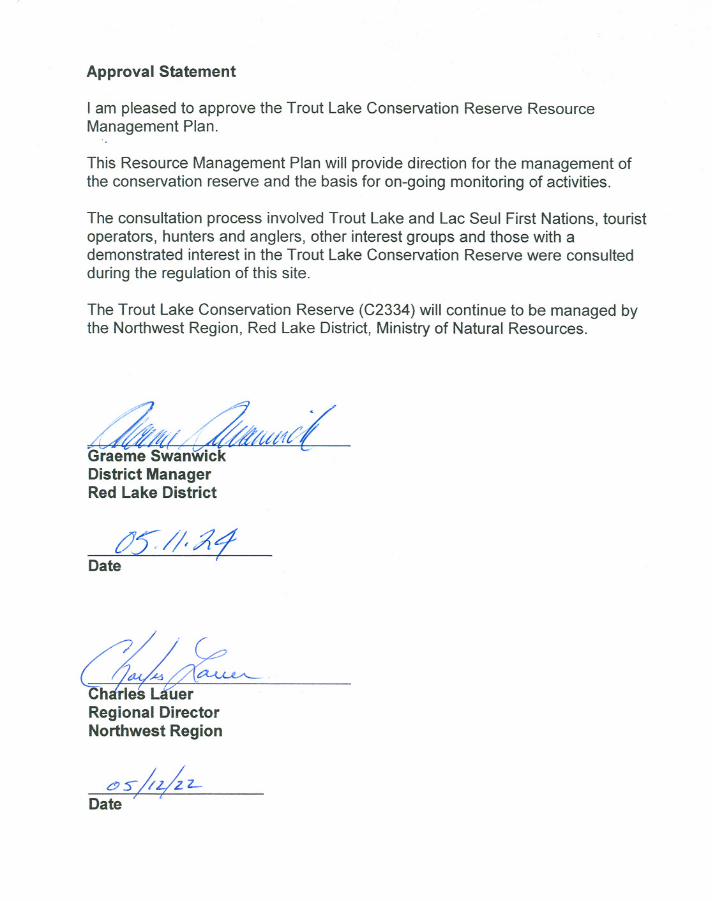
Approval Statement
I am pleased to approve the Trout Lake Conservation Reserve ResourceManagement Plan.
This Resource Management Plan will provide direction for the management ofthe conservation reserve and the basis for on-going monitoring of activities.
The consultation process involved Trout Lake and Lac Seul First Nations, touristoperators, hunters and anglers, other interest groups and those with ademonstrated interest in the Trout Lake Conservation Reserve were consultedduring the regulation of this site.
The Trout Lake Conservation Reserve (C2334) will continue to be managed bythe Northwest Region, Red Lake District, Ministry of Natural Resources.
~ftl/~$t4~Graeme SwanwickDistrict ManagerRed Lake District
tJS:/I/{?Date
a;J~~CharleRegional DirectorNorthwest Region
~~;;0Z-Date