tsunami evacuation map for the lummi reservation reservation.pdf · south red rd marine dr scott rd...
TRANSCRIPT
WHAT IS A TSUNAMI?
A tsunami is a series of waves most commonly caused by an earthquake beneath the sea floor. As tsunamis enter shallow water near land, they increase in height and can cause great loss of life and property damage where they come ashore.
Recent research suggests that tsunamis have struck the Washington coast on a regular basis. They can occur at any time of the day or night, under any and all weather conditions, and in all seasons. Beaches open to the ocean, bay entrances, tidal flats, and coastal rivers are especially vulnerable to tsunamis.
WHAT IS THE DIFFERENCE BETWEEN A ‘DISTANT’ AND A ‘LOCAL’ TSUNAMI?
When a tsunami has been generated by a distant earthquake, it will not reach the Washington coast for several hours, and there is time to issue a warning. When a tsunami is generated by a strong offshore earthquake, its first waves would reach the outer coast minutes after the ground stops shaking. Feeling an earthquake could be your only warning!
WHAT CAN I DO TO PROTECT MYSELF FROM A TSUNAMI?
Develop a family disaster plan. Everyone needs to know what to do on their own to protect themselves in case of disaster.Be familiar with local earthquake and tsunami plans. Know where to go to survive a tsunami. Identify an evacuation site within 15 minutes walking distance of home and/or work. Prepare three-day emergency kits for your home, automobile, and work.Take a first aid course and learn survival
skills. Knowledge is your greatest defense against potential disaster.
HOW DO I KNOW WHEN TO EVACUATE?
If you feel the ground shake, evacuate inland or to high ground immediately! A wave as high as 9 feet could reach the Lummi Reservation within 2¼ hours of the quake. The first wave is often not the largest; successive waves may be spaced many minutes apart and continue to arrive for several hours. Return only after emergency officials say it is safe.
Isolated areas may not receive official warnings of distant tsunamis. If you notice a sudden drop or rise in sea level, move to high ground or inland immediately.
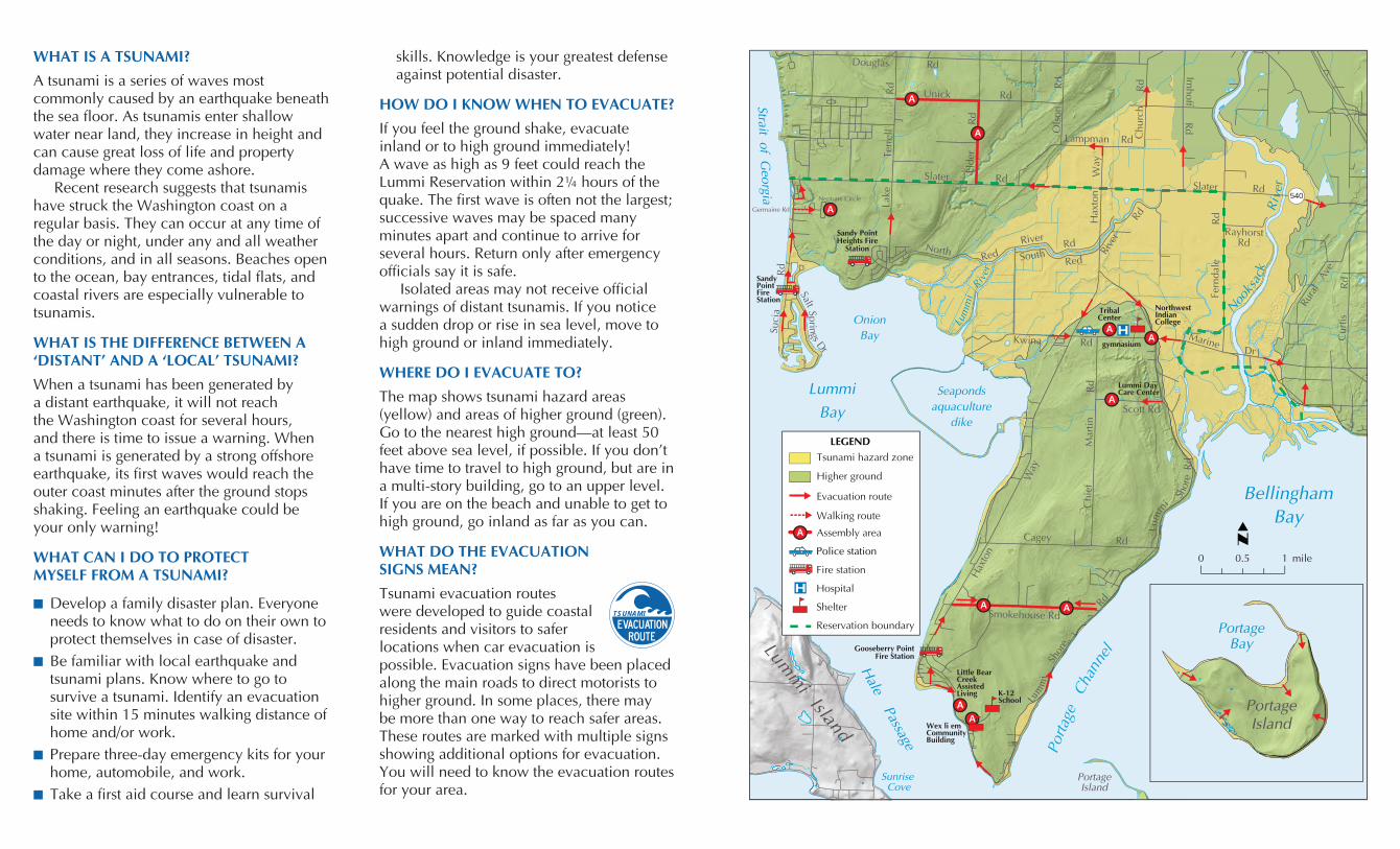
WHERE DO I EVACUATE TO?
The map shows tsunami hazard areas (yellow) and areas of higher ground (green). Go to the nearest high ground—at least 50 feet above sea level, if possible. If you don’t have time to travel to high ground, but are in a multi-story building, go to an upper level. If you are on the beach and unable to get to high ground, go inland as far as you can.
WHAT DO THE EVACUATION SIGNS MEAN?
Tsunami evacuation routes were developed to guide coastal residents and visitors to safer locations when car evacuation is possible. Evacuation signs have been placed along the main roads to direct motorists to higher ground. In some places, there may be more than one way to reach safer areas. These routes are marked with multiple signs showing additional options for evacuation. You will need to know the evacuation routes for your area.
AA
A
AA
LEGEND
H
A
Police station
Fire station
Hospital
Shelter
Reservation boundary
Evacuation route
Tsunami hazard zone
Assembly area
Higher ground
H
540
mile0.5 10
Walking route
A A
A
A
A Riv
er
Lake
T
erre
ll
Rd
NorthRed
RiverRd
RayhorstRd
Fern
dale
Rd
Slater RdSlater Rd
SouthRed
Rive
r
Rd
Marine Dr
Scott Rd
Chi
efM
artin
RdLummi
Bay
OnionBay
Seapondsaquaculture
dike
BellinghamBay
Porta
geCh
anne
l
Hale Passage
SunriseCove
PortageIsland
Lumm
i Island
SandyPointFireStation
Cagey Rd
Smokehouse Rd
L
Shor
e
Rd
Lum
m
i
Shor
eR
d
Hax
ton
Way
Kwina Rd
Suci
aR
d
Unick Rd
Lampman Rd
Ols
on
R
d
Douglas Rd
Imhoff
Rd
Hax
ton
Way
Chu
rch
R
d
Rura
l A
veC
urtis
R
d
Lummi DayCare Center
TribalCenter
NorthwestIndianCollege
gymnasium
Sandy PointHeights Fire
Station
K-12School
Wex li emCommunityBuilding
Little Bear CreekAssistedLiving
Gooseberry PointFire Station
PortageIsland
Nooks
ack
Lum
mi
River
PortageBay
Strait of Georgia
Salt Springs D
r
Elde
r
R
d
Germaine Rd
Neptune Circle
TSUNAMI

HOW DO I GET INLAND OR TO HIGH GROUND?
Car evacuation may not be possible if an earthquake has damaged roads and power lines and resulted in significant debris. If this is the case, do not try to follow the evacuation routes out. Evacuate on foot directly to the nearest high ground. Avoid lakes and wetlands, which are prone to flooding and liquefaction during aftershocks.
WHAT SHOULD I HAVE IN MY EMERGENCY KIT?
You should prepare an emergency kit with a three-day supply of necessary items for each member of your family. The kit should be adapted to your needs, but keep it light and manageable in case you must evacuate on foot. Have it ready to go for immediate evacuation. Possible supplies include:
Maps showing safe routes to high ground Non-perishable food and cooking and eating utensils, including can opener
Water and a water purification kit First-aid kit and prescriptions Plastic bags for water storage and waste Dental and personal hygiene items Sturdy shoes, clothes, sleeping bag, tent Portable radio, headlamp/flashlight, and extra batteries
Pocket knife, whistle, matches, duct tape, and rubber, latex, and heavy-duty gloves
WHERE CAN I STAY UNTIL THIS IS OVER?
Local emergency management has tried to designate safe assembly areas within a reasonable distance for foot traffic. If you are at risk from a tsunami, but do not have an “official” assembly area close by,
you are urged to develop a neighborhood evacuation site. The site should be outside the tsunami hazard area, easy to get to, and capable of accommodating the number of people expected. If it is on private property, you will need the permission of the owner.
After the immediate danger is past and if there is damage to the degree that you cannot return home, you should then attempt to reach a designated assembly area. Since this may not be possible, it is a good idea to inform your local emergency manager of the location of your neighborhood evacuation site.
DOES MY COMMUNITY HAVE ANY PLANS IN PLACE?
Outdoor assembly areas have been selected to facilitate delivery of emergency services. It may be several days before help can arrive, so if possible, bring your own three-day emergency kit and emergency shelter.
The assembly areas listed below are not specific in terms of boundaries. You may camp or park in adjacent areas. Take care not to block a roadway—leave access for emergency vehicles. Assembly areas must be on publicly owned property.
Designated assembly areas are LIBC Tribal Center, Northwest Indian College, Lummi Day Care Center, Little Bear Creek Assisted Living Center, Wex li em Community Building, Smokehouse Road on both sides of the street, the westbound lane of Unick Road between Lake Terrell Road, and the northbound lane of Elder Road north of Slater Road.
WHAT ARE THE EMERGENCY RADIO FREQUENCIES?
NOAA Weather Radio Blaine, 162.525 MHzLocal news updates, KGMI 790 AM.
WHO CAN I CONTACT FOR MORE INFORMATION?THE LUMMI NATION2616 Kwina Road, Bellingham, WA 98226360-384-1489http://www.lummi-nsn.gov
WHATCOM COUNTY SHERIFF’S OFFICEDIVISION OF EMERGENCY MANAGEMENT311 Grand Ave, Suite B-08Bellingham, WA [email protected]://www.co.whatcom.wa.us/dem/
WASHINGTON MILITARY DEPARTMENTEmergency Management DivisionCamp Murray, WA 98430-5122800-562-6108http://www.emd.wa.gov/
This brochure was produced by the Washington State Department of Natural Resources,
Division of Geology and Earth Resources, http://www.dnr.wa.gov/.
WHEN YOU FEEL AN EARTHQUAKE:
Protect yourself—drop, cover, hold until the earthquake is over
Grab your three-day emergency kit Move quickly inland to high ground and away from low-lying coastal areas
Evacuate on foot if at all possible because of potential road damage and traffic jams
Do not wait for an official warning Do not pack or delay Do not return to the shore Listen to NOAA Weather Radio or your local radio station for information on shelter locations and emergency broadcasts
Be alert for aftershocks Do not return to the beach until emergency officials say it is safe
Printed on recycled paper July 2007
EvacuationMap for
the LummiReservation
EvacuationMap for
the LummiReservation
Safety Tips forWhatcom CountySafety Tips forWhatcom County