tsunami hazard mapping and risk assessment for … · tsunami hazard mapping and risk assessment...
TRANSCRIPT

www.last-mile-evacuation.de Prof. Dr. T. Schlurmann1
Leibniz Universität Hannover
Franzius-Institut for Hydraulic, Waterways and Coastal Engineering
Prof. Dr. Torsten Schlurmann
Managing Director & [email protected]
Prof. Dr. T. Schlurmann
TSUNAMI HAZARD MAPPING AND RISK ASSESSMENT FOR THE
CITY OF PADANG / WEST SUMATRAby: N. Goseberg and T. Schlurmann
Disaster Risk Reduction for Natural Hazards:
Putting Research into Practice
November 4th-6th 2009 at University College London
(DFG/BMBF Förderkennzeichen: 03G0666A-H)
www.last-mile-evacuation.de

www.last-mile-evacuation.de Prof. Dr. T. Schlurmann2
Brief outline of presentation
1. Background & Motivation
2. Project Organization
(Geo)Data collection and household survey
Methodological approach (transdisciplinary collaboration)
3. Preliminary findings
4. Disaster Management in consequence of Sept. 2009 quake
5. Summary and Outlook -> Urgent demands for DRR in Padang

www.last-mile-evacuation.de Prof. Dr. T. Schlurmann3
Facts about Padang, West Sumatra, Indonesia Approximately 900.000 inhabitants, Low-lying coastal region (<10m)
Net of urban waterways, Major historical tsunamis 1797: 9m and 1833: 6m
Seismically “locked” area, likelihood of earthquake and subsequent tsunamis
is extremely high in near future: 5-10 years?! (i.e. McCloskey et al., UCL-DRR)
1. Background & Motivation

www.last-mile-evacuation.de Prof. Dr. T. Schlurmann4
Motivation and major research objectives Assess characteristic tsunami inundation dynamics for urban agglomeration
(Padang) on micro-scale temporal and spatial resolution based on newly derived
geodata-basis and credible future earthquake scenarios
Determine socio-economic hotspots of vulnerability (special assistance) and
assess disaster preparedness (determine: “evacuation readiness”)
Outline best evacuation routes (optimize) and detect time-dependent bottlenecks
Determination of safe areas in Padang and assist authorities in DRR
Facts about Padang, West Sumatra, Indonesia Approximately 900.000 inhabitants, Low-lying coastal region (<10m)
Net of urban waterways, Historical tsunamis 1797: 9m and 1833: 6m
Seismically “locked” area, likelihood of major earthquake and subsequent
tsunami is extremely high in near future: 5-10 years? (McCloskey et al.)
1. Background & Motivation
___
Improve decentralized, vertical evacuation and develop tsunami proof shelters
Initiate spatial planning processes (ICZM) to minimize tsunami disaster risk in
Padang by means of Capacity Building, i.e. individuals and institutions
Communicate with stakeholders and assist to transfer and implement DRR
methods/strategies within other coastal communities in the region
www.last-mile-evacuation.de Prof. Dr. T. Schlurmann5
Brief outline of presentation
1. Background & Motivation
2. Project Organization
(Geo)Data Collection and Household Survey
Methodological approach (Transdisciplinary Collaboration)
3. Preliminary findings
4. Disaster Management in consequence of Sept. 2009 quake
5. Summary and Outlook -> Urgent demands for DRR in Padang
www.last-mile-evacuation.de Prof. Dr. T. Schlurmann6
2. Project Organization
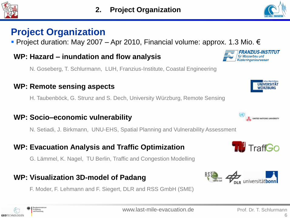
Project Organization Project duration: May 2007 – Apr 2010, Financial volume: approx. 1.3 Mio. €
F. Moder, F. Lehmann and F. Siegert, DLR and RSS GmbH (SME)
G. Lämmel, K. Nagel, TU Berlin, Traffic and Congestion Modelling
H. Taubenböck, G. Strunz and S. Dech, University Würzburg, Remote Sensing
WP: Hazard – inundation and flow analysis
WP: Socio–economic vulnerability
WP: Evacuation Analysis and Traffic Optimization
WP: Visualization 3D-model of Padang
N. Goseberg, T. Schlurmann, LUH, Franzius-Institute, Coastal Engineering
WP: Remote sensing aspects
N. Setiadi, J. Birkmann, UNU-EHS, Spatial Planning and Vulnerability Assessment

www.last-mile-evacuation.de Prof. Dr. T. Schlurmann7
2. Project Organization
Project Organization – (Geo)data collection and HH-survey Multibeam echosoundings (bathymetry), Airborne HRSC (topography & terrain)
Bathymetrical Survey
3x3m spatial res.
Flight campaign
20x20cm sp. res.
+/- 40cm abs. vert.
resolution
www.last-mile-evacuation.de Prof. Dr. T. Schlurmann8
2. Project Organization
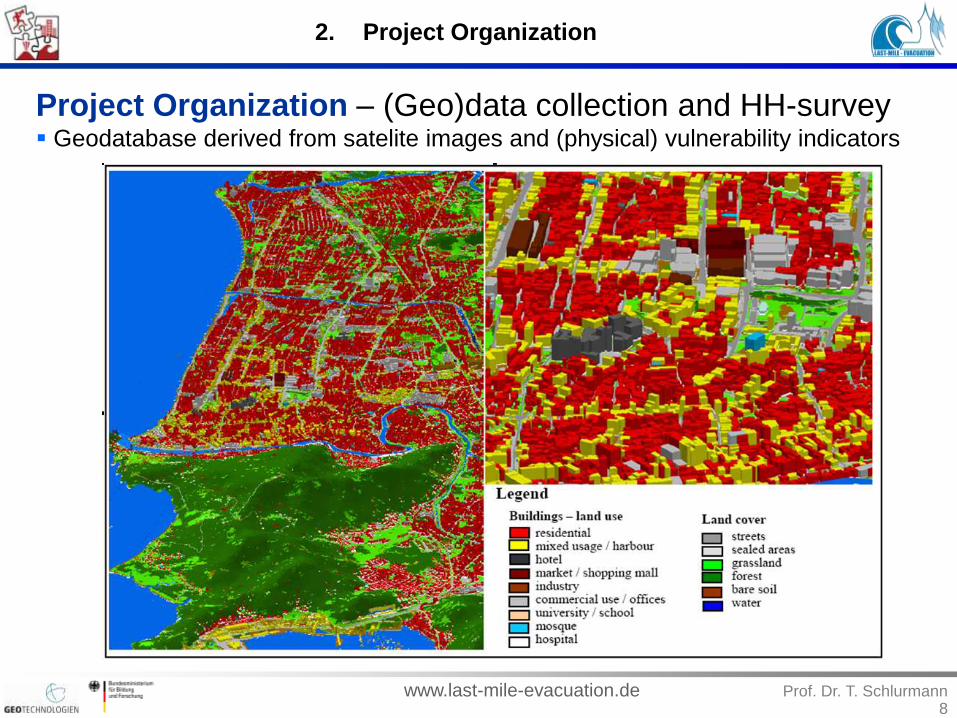
Project Organization – (Geo)data collection and HH-survey Geodatabase derived from satelite images and (physical) vulnerability indicators

www.last-mile-evacuation.de Prof. Dr. T. Schlurmann9
2. Project Organization
Project Organization – (Geo)data collection and HH-survey Household survey (Sample size 1000 HH) - Collection and evaluation of existing
statistical data questionnaire-based survey, in co-operation with UNAND
Potential
indicators
Warning
dissemination
Evacuation
Warning
decisionExposure
Susceptibility
Coping Capacity
Indicators
Indicators
Indicators
Indicators
Indicators
Indicators
Exposed People
Receiving the warning
Decision to evacuate
Capability to evacuate
Understanding the warning
Exposed critical infrastrctures
Evacuation
BBC framework
categories
Warning and response
phases
Thematic areas for indicator
development
V
U
L
N
E
R
A
B
I
L
I
T
Y

www.last-mile-evacuation.de Prof. Dr. T. Schlurmann10
Land cover classification
Physical urban structure analysis
Population density function of time
Project Organization - Methodological approach (Collaboration) Land-cover and land-use classification, determination of mobility/activity patterns
2. Project Organization

www.last-mile-evacuation.de Prof. Dr. T. Schlurmann11
2. Project Organization
Project Organization - Methodological approach (Collaboration) Dynamic Exposure & Vulnerability Map
Precise assessment of vulnerable population
through identification of main activities and mobility
of the working activity (census & HH survey):
Spatial distribution of demographic groups
(gender, age, education, etc.)
Household income and poverty status
Critical infrastructure and facilities
Time-dependent, spatial distribution of
working places & settlement areas

www.last-mile-evacuation.de Prof. Dr. T. Schlurmann12
2. Project Organization
Project Organization - Methodological approach (Collaboration) Idea of „semantic classification“ – Interrelation between complex urban
morphology and the socio-economic characteristics of residents in Padang
Buildings

www.last-mile-evacuation.de Prof. Dr. T. Schlurmann13
2. Project Organization
Project Organization - Methodological approach (Collaboration) Hydronumerical modelling - Coupling ANUGA with TsunAWI (later w/ Hilman et al.)
TsunAWI
– NLSW equation, source
generation (RuptGen)
– FE-method on unstructured
meshes
ANUGA
– NLSW equation, on land flow
– FV-method, unstructured triang. cells
– Open Source, wetting/drying, captures
hydraulic jumps, MPI-implementation

www.last-mile-evacuation.de Prof. Dr. T. Schlurmann14
2. Project Organization
Project Organization - Methodological approach (Collaboration) Multi-scenario approach (GITEWS), footprint of houses, structures and vegetation

www.last-mile-evacuation.de Prof. Dr. T. Schlurmann15
Brief outline of presentation
1. Background & Motivation
2. Project Organization
(Geo)Data Collection and Household Survey
Methodological approach (Transdisciplinary Collaboration)
3. Preliminary findings
4. Disaster Management in consequence of Sept. 2009 quake
5. Summary and Outlook -> Urgent demands for DRR in Padang

www.last-mile-evacuation.de Prof. Dr. T. Schlurmann16
3. Preliminary findings
Preliminary findings Sensitivity study I: Maximum inundation scenario Mw 8.5, Sz 03

www.last-mile-evacuation.de Prof. Dr. T. Schlurmann17
Preliminary findings Sensitivity study I: Maximum inundation scenario Mw 8.5, Sz 02
3. Preliminary findings

www.last-mile-evacuation.de Prof. Dr. T. Schlurmann18
3. Preliminary findings
Preliminary findings Sensitivity study II: Manning’s roughness value “m” of surface terrain - Variation of
roughness parameters m = 20, 35, 70, 100 m1/3/s yield major differences

www.last-mile-evacuation.de Prof. Dr. T. Schlurmann19
3. Preliminary findings
Preliminary findings Sensitivity study III: Strong deviations in between maximum tsunami inundation
scenarions derived from i) “flat” DSM and ii) DEM w/ structures, houses, etc.
i) “flat” DSMii) DEM w/ structures, houses, etc.

www.last-mile-evacuation.de Prof. Dr. T. Schlurmann20
3. Preliminary findings
Preliminary findings Quantitative approach: Household survey
Qualitative approach: Discussion with local experts
52,41%
63,3%
5,6%
68,3%
31,3%
94,3%
39,8%
0 0,1 0,2 0,3 0,4 0,5 0,6 0,7 0,8 0,9 1
Social network
SMS
Radio
TV
Availability of warning media - Receiving the warning through the media
Availability Receiving through available media
= 46%
= 42%
= 9%
Dissemination
(availability /
receiving)
Media for official notification
Media for informal notification
Clearness of
the warning
= 68%
= 52%
Media effectiveness:
1 Social network
(community-based)
2 Radio
3 TV
4 SMS
Technical failure
in emergency
(qualitative)
= 90%
- -
-
- -
+
Community-based dissemination through community
response team or mosques empowerment is more
effective for early warning!
www.last-mile-evacuation.de Prof. Dr. T. Schlurmann21
3. Preliminary findings
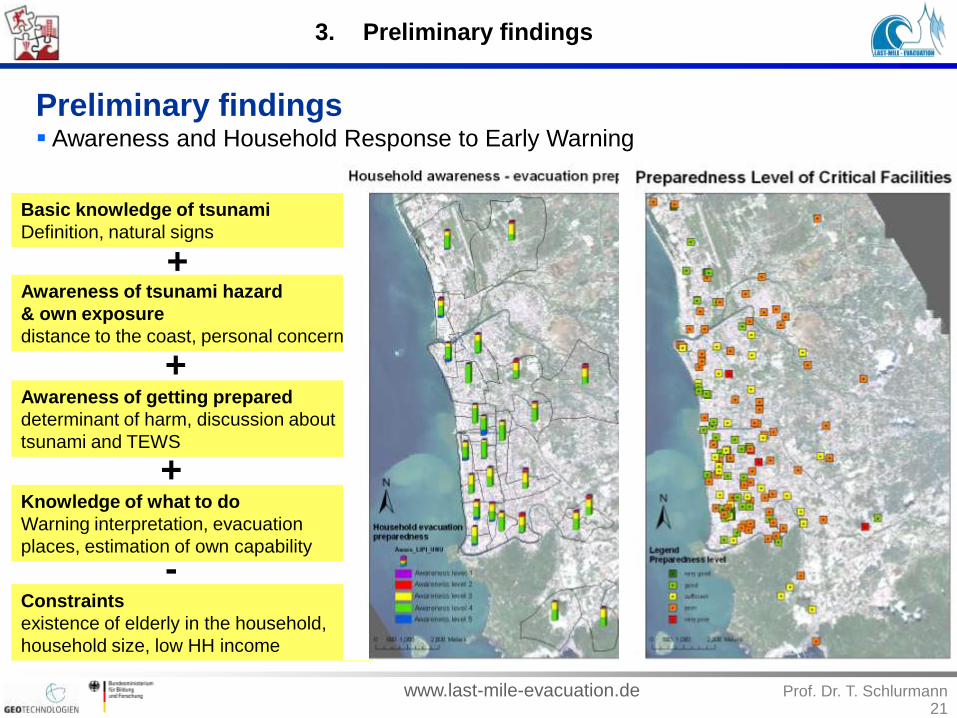
Preliminary findings Awareness and Household Response to Early Warning
Basic knowledge of tsunami
Definition, natural signs
Awareness of tsunami hazard
& own exposure
distance to the coast, personal concerns
Awareness of getting prepared
determinant of harm, discussion about
tsunami and TEWS
Knowledge of what to do
Warning interpretation, evacuation
places, estimation of own capability
Constraints
existence of elderly in the household,
household size, low HH income
+
+
+
-

www.last-mile-evacuation.de Prof. Dr. T. Schlurmann
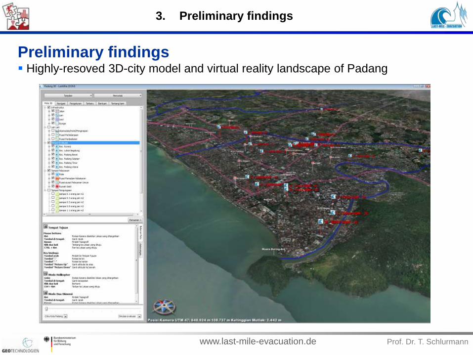
Preliminary findings Highly-resoved 3D-city model and virtual reality landscape of Padang
3. Preliminary findings
www.last-mile-evacuation.de Prof. Dr. T. Schlurmann
Preliminary findings Highly-resoved 3D-city model and virtual reality landscape of Padang
3. Preliminary findings

www.last-mile-evacuation.de Prof. Dr. T. Schlurmann24
Brief outline of presentation
1. Background & Motivation
2. Project Organization
(Geo)Data Collection and Household Survey
Methodological approach (Transdisciplinary Collaboration)
3. Preliminary findings
4. Disaster Management in consequence of Sept. 2009 quake
5. Summary and Outlook -> Urgent demands for DRR in Padang

www.last-mile-evacuation.de Prof. Dr. T. Schlurmann25
4. Disaster Management
Disaster Management in consequence of Sept. 2009 quake Earthquake 09/30/2009, 5.16pm, Mw 7.6, depth: 81km, 50km off coast of Padang
Courtesy of USGS, 2009

www.last-mile-evacuation.de Prof. Dr. T. Schlurmann26
4. Disaster Management
Disaster Management in consequence of Sept. 2009 quake Current Rapid Mapping and Disaster Management Activities

www.last-mile-evacuation.de Prof. Dr. T. Schlurmann27
Brief outline of presentation
1. Background & Motivation
2. Project Organization
(Geo)Data Collection and Household Survey
Methodological approach (Transdisciplinary Collaboration)
3. Preliminary findings
4. Disaster Management in consequence of Sept. 2009 quake
5. Summary and Outlook -> Urgent demands for DRR in Padang

www.last-mile-evacuation.de Prof. Dr. T. Schlurmann28
5. Outlook and demands in DRR
Summary & Outlook Transdisciplinary approach in “Last-Mile – Evacuation” proves to establish new
dimension of DRR research on a spatially and time-dependent micro-scale
See: Taubenböck et al., NHESS, Vol. 9, Number 4, 2009, pp. 1509-1528
Urgent demands for DRR in Padang Present and discuss results of study with stakeholders and local decision
makers -> Continue to support the so-called “Padang Consensus” process
Strong need to construct tsunami evacuation shelters nearshore (SOP)
Try to achieve to implement results into local spatial planning & co-ordination
Capacity Building (additional workshops) with UNAND and disaster
management agencies (BNPB) and other city authorities
Mainstream findings as well as recommendations from Padang to transfer
outcome to other imperiled coastal regions in West Sumatra, Indonesia
Further sensitivity analysis and calibration with other hydronumerical models
and initial slip distribution needed (account results from McCloskey et al., 2009)
Closely evaluate evacuation analysis and traffic optimization (not shown here!)
Summarize and synthesize work packages and implement in online 3D-viewer
Broad dissemination of DRR research results in Padang to scientific communities

www.last-mile-evacuation.de Prof. Dr. T. Schlurmann29
Thank you very much
for your attention!