tuckingmill roskear appraisal amended … · 24 tuckingmill & roskear conservation area...
TRANSCRIPT

24 Tuckingmill & Roskear Conservation Area Appraisal
4.0 Characterisation
Tuckingmill Chapel, Chapel Road
Building Materials
Tuckingmill-Roskear is predominantly a stone-built
settlement. Although granite is used to great effect on many of the more prominent buildings in
Tuckingmill, and especially on the Bickford-Smith buildings, the predominant stone is the honey-
coloured to dark brown variant of the local killas country rock. Granite is typically used on humbler
buildings only for lintels and quoins, but its worth noting that the same combination is also found on
much grander buildings - All Saints Church shows the same choice of local stone with granite
detailing.
Local slate is the almost universal traditional roofing
material; much of it has been replaced by various artificial (or ‘mineral’ slates) and by imported
slates. The latter at least maintain the broad traditional colour and textural qualities. Traditional
scantle slating, where slate is laid in diminishing courses, is still evident on buildings within the
Conservation Area.
Slate hanging makes an occasional and attractive appearance, usually in relatively small quantities
(19 Pendarves Road, the old Vicarage, various rear and side gables among the cottage rows):
inevitably it is in the traditionally small sized (or scantle), wet laid, light grey Cornish slate. This
material and usage is never appropriately replaced
by the large, dull greys and blacks of other natural or artificial materials.
Red brick stacks and crested clay ridge tiles
decorate many roofs, especially the larger houses and villas. The roofs along Roskear retain fine
banded slate roof patterns. Brick is used on some of the industrial buildings and rear extensions for
lintels and quoins.
Tuckingmill-Roskear is a good place to see a wide variety of timber and metal ornamental details.
Many of the cottages have lost their traditional timber fenestration to a variety of inappropriate
replacements, especially along Pendarves Road. For instance chunky, flat-sectioned PVCu has been
used. The survival rate of traditional timber shopfronts has also been very poor (see the 2005
Tuckingmill Shopfront Survey commissioned by
Kerrier District Council).
There are still several good examples of surviving timber windows (mostly along the main road) and
there are some remnant shopfronts still with traditional detailing surviving, or able to be
effectively restored (10 East Hill; Wanga House; 45, 85 and 103-107 Pendarves Road). The best
example of commercial joinery in Tuckingmill, and perhaps the whole area, is the former joinery
workshop to the rear of 85 Pendarves Street, which is timber clad with surviving original glazing bars.
There are also fine examples of decorative joinery
work – stained glass storm porches or conservatories on 4 East Hill or 21-23 and 24
Roskear, and of carved bargeboards on 30 Church View Road and the Bickford Smith offices.
Although iron railings have almost entirely
disappeared from Tuckingmill (as they have elsewhere) , there is an impressive array still to be
seen in the forecourt of the Methodist Chapel, and evidence all around the Conservation Area for their
former existence in the mortise marks on granite coping stones.
Surviving rather better are small scale, elaborate
cast iron finials and window boxes – seen best on
the listed 21/23 Roskear. The cast and wrought veranda attached to Wanga House is one of the
best examples of domestic architectural metalwork to be found anywhere in the Camborne-Redruth
conurbation.
Wanga House, Pendarves Street
March 2010

Tuckingmill & Roskear Conservation Area Appraisal 25
4.0
Front entrance to Tuckingmill Chapel
Bickfords Range, Pendarves Street
Former Workshop, North Roskear Road East Hill Roskear
Church View Road
Former Laity’s Bakery, Pendarves Street
Slate hanging, Pendarves Street
March 2010

26 Tuckingmill & Roskear Conservation Area Appraisal
4.0 Characterisation
The definitions of the various listing ‘grades’ used
are as follows;
Grade I: building of outstanding architectural or historic interest.
Grade II*: particularly significant buildings of
more than local interest.
Grade II: buildings of special architectural or historic interest. The vast majority of buildings are
listed at this grade.
Listed buildings & Scheduled
Ancient Monuments
The Conservation Area was designated as two separate but contiguous designations – South
Roskear and Tuckingmill (designated March 1995). The two have been merged as a single designation
for this appraisal, with no alteration to the overall boundaries.
There are no scheduled monuments in the
Conservation Area, but there are 9 listed buildings, all of which are listed Grade II. These are the
former Tuckingmill Methodist Chapel, the parish church and associated parish school, the office and
frontage building at Bickford-Smith fuseworks, and
three stone villas in Roskear, the Tuckingmill Hotel and the adjacent no. 107 Pendarves Street, the
latter all dating from soon after the creation of the turnpike road in 1839.
Although there are many listed industrial structures
in the wider area, only the early 20th century Bickford-Smith offices reflect this in the
Conservation Area. These are listed primarily for their architectural and streetscape qualities,
although the historical importance of the Bickford-Smith factory has been brought out in the list
description.
Tuckingmill had only a few significant public buildings compared to many local settlements, and
the four principal surviving ones are listed (churches, school and hotel).
There is no list of locally significant historic
buildings.
Tuckingmill is included in the Kerrier District Local
Plan in the list of towns and villages of historic origin based on its industrial heritage.
Tuckingmill-Roskear Conservation Area – Listed
Buildings;
Chapel Road Former Tuckingmill Methodist Chapel II
Church View Road Former Parochial
School And No.75 II
107 Pendarves Street Former Laity's Bakery II
109 Pendarves Street Tuckingmill Hotel II
Pendarves Street Church Of All Saints II
Front Range To Former
Bickford Smith's Fuseworks II
Roskear Nos. 21 & 23 II
No. 25 II
Nos. 27 & 29 II
Tuckingmill Chapel, Pendarves Street Tuckingmill Hotel, Pendarves Street
March 2010

Tuckingmill & Roskear Conservation Area Appraisal 27
Conservation area boundary extensions
4.0 Characterisation
Listed Buildings
Buildings that contribute positively to
Conservation Area
Negative Buildings
Conservation Area
Proposed boundary extensions to
Conservation Area
Map showing levels of protection
March 2010

28 Tuckingmill & Roskear Conservation Area Appraisal
4.0 Characterisation
Public realm and landscape
Tuckingmill-Roskear is not a place notable for the
wide extent of its historic streetscape details, but there are small, well-defined areas of historic
paving of exceptional interest. Most are clearly related to the large industrial complexes, including
the several areas of granite set crossovers to the various entrances to the Bickford-Smith complex.
One of these areas was in Chapel Road, and has been regrettably removed as part of the creation of
the inappropriately detailed, suburban-style driveway to Chapel Close. Within the courtyards of
both the Bickford’s complex and the South Roskear mine yard are extensive granite and stone-paved
areas of high quality, while even the former
Bennets fuseworks site retains some well-cut granite gate posts.
Other small areas of interesting surfacing include
the unusual combination of cobbling and granite paving in the ramped forecourt to the old Methodist
Chapel, and the fine crushed stone metalling of Penlu, possibly the original paving material, and
among the rarest and most interesting examples of surfacing to be found anywhere in the wider
conurbation.
There are stretches of granite kerbing to be found throughout the area, but with only one substantial
area of cobbled guttering, in South Roskear
Terrace. Edward Street is an interesting example of the simple arrangement of macadamised
pavements with granite kerbs and slab thresholds marking doors and shopfronts. Granite thresholds,
plinths and crossovers can also be seen along 103-109 Pendarves Street.
Street furniture is largely confined to standard grey
steel street lights, which are particularly intrusive marching down Pendarves Street. Away from the
main road traffic signs have largely been kept to a minimum, rarely intruding too much into the
streetscene, although Pendarves Street is remarkable for the sheer quantity of paintwork on
the road surface. The chicane-like build outs along
its length also do little either to slow traffic or enhance the streetscape.
East Hill has more in the way of signs and traffic
islands, and the crash-barrier balustrade to the Embankment contrasts poorly with the
quality of the stonework. None of this contributes to the quality of the pedestrian environment and
certainly does not enhance the character or appearance of the Conservation Area.
Walls form a consistently important part of the
streetscape in all their various forms: as hedges (Church View Road), retaining banks built up of
mine waste and deads (Scowbuds, Tolgarrick, the southern edge of the Basset Rows), rubble stone
garden walls (the Basset Rows) or fine, cut stone walls, with ornamented gate piers, stone capping
etc, often formerly with railings (97-99, 101
Pendarves Street; Roskear). Most impressive are the great blank hammer-dressed or rusticated
enclosing walls of the Bickford’s complex, or of South Roskear, or the massive engineering of the
East Hill embankment. Indeed the re-use of the ashlar stone from Pendarves House at the
embankment is particularly impressive and poignant given the association of the family with
Tuckingmill.
Commemorative plaques are small but important streetscape elements in the Tuckingmill-Roskear
area. The best example is the cast metal plaque on the side of the Bickford-Smith complex, but there is
also the dedication stone of the Institute/Baptist
Church, and the carved heraldic name-stones at the entrance to King George’s fields.
There are good surviving examples of the
traditional hierarchy of surfaces. Good quality granite is often used for the setting of key
commercial buildings while less grand, but still ‘polite’ macadamised pavements with granite
detailing are used in the residential streets. Roads throughout are macadamised, but rough
unmetalled tracks survive in the back lanes and, crucially, the Basset Rows. Where some of these
back lanes have been tarmaced, a loss of texture and character is apparent.
The most notable example is between Edward
Street and Pendarves Street, where the lane has been tarmaced, marked out with painted white
lines, and given a full run of street lights, so that it is now more like a through-road than Edward
Street itself.
The limited streetscape works done so far in Tuckingmill-Roskear have all been aimed at traffic
management (and providing some parking) in Pendarves Street, and have had limited success
and little enhancing effect on the street scene. Further works could take inspiration from the
linearity of the streetscape, the quality of the surrounding built environment and the simple and
low-key historic streetscape details. It might also,
however, draw inspiration from the quality of planted and green streetscapes throughout the
Conservation Area (i.e. consider introduction of street trees), while maintaining a suitably urban
characteristic.
An urban park has been created at Tuckingmill Valley Park to the north of the crossroads at the
Pendarves Street, East Hill junction. Although outside of the Conservation Area the park provides
an attractive recreational space as well as a pleasant green backdrop to the lower end of the
valley. The park contains consolidated calciner chimneys which provide reference to the
area’s important industrial past.
A section of historic paving at the Bickfords Range,
Pendarves Street
March 2010

Tuckingmill & Roskear Conservation Area Appraisal 29
4.0 Characterisation
Key to Views
1) View down North Roskear Road
2) View from Scowbuds
3) View down East Hill
4) View up Pendarves Street
5) View down Pendarves Street
6) View of South Crofty from Chapel Road
7) View up Red River Valley from Chapel Road
8) View down Church View Road
9) View up Roskear from All Saints Church
10) View up Roskear from Roskear Road
11) View up South Roskear Terrace
12) View North East up Edward Street
13) View South West down Edward Street
14) View South down South Roskear Terrace
15) View of South Crofty from Lidls car park
16) View up East Hill
17) View from North Roskear branch line
18) View from Pavilion Park
15
Key Views and Vistas
16
17
18
March 2010

30 Tuckingmill & Roskear Conservation Area Appraisal
4.0 Characterisation
Key views, vistas and greenery
The A30 by-pass provides great views of the
whole of the Camborne-Redruth mining area. The viaduct over the deep Red River valley reveals the
scale of the mining remains, and South Crofty in particular is seen as a great collection of buildings.
The scale, shape and even the use of metal cladding there puts it in the same class as other
iconic mining sites such as Geevor, at the heart of the Cornish Mining World Heritage site. Seen
against the green backdrop of Carnarthen and Carn Entral, it is one of the most powerful
surviving images of Cornwall’s industrial past.
The views from the south are no less spectacular
in their own way, particularly from Carn Entral. However, the foreground and the wider views are
of a rather formless area of old mine waste, poorly laid out housing development spreading out from
Camborne, and a scatter of anonymous industrial sheds. The ridge line along which the turnpike
road runs stands out very clearly, and the chapel and the parish church are dominant. The headgear
of South Roskear mine is as prominent as the buildings at South Crofty. The scattered engine
houses and chimneys in the area provide a visual reminder of the area’s industrial past. It is also
clear just how narrow the historical development along the turnpike road was – although the
industry has gone, development has not yet
spread out to obscure the historic character of the settlement.
Distant views from within Tuckingmill are less
obvious, although Carn Entral remains a surprisingly dominant feature in many streetscape
views. The commercial and educational buildings around Trevenson Road and Dudnance Lane crown
the crest of the valley and frame views from Roskear and the western part of the Conservation
Area.
Dominating the opposite valley crest is the parish church, which stands at one of the highest points
along the main axis and is a landmark from many places within the settlement. The glimpses of the
church through its surrounding trees, especially seen from some of the enclosed streets or open
spaces and small parks around Tuckingmill- Roskear make for one of the surprising joys of the
Conservation Area.
On a map Tuckingmill appears to be hemmed in by other settlements, development, the railway and
roads, but actually on the ground the impression of the wider landscape setting is very different. There
is a tangible presence of not only the wide areas of
former industrial land, but also of the hills to the south of the railway. The remnant industrial land is
now largely overgrown with scrub, and actually the slopes of the Red River valley were never as bare
and blasted as old photographs might at first suggest, especially in the eastern side south of
South Crofty. In fact there are surviving closes and hedgerows, lanes and gateways here.
Considering the very urban appearance of many of
the streets in Tuckingmill, the amount of trees and greenery visible in more distant views is surprising,
particularly around the church and along Roskear towards Camborne.
The churchyard is the only substantial green area actually within the Conservation Area, containing
many mature trees, with the evergreen varieties there making it particularly important in year -
round views. It is a quiet and charming space which provides some of the most picturesque
views in the area.
Roskear and Roskear Road are the only parts of the core area where mature trees and planting
impact directly onto the main road, although in
other areas like Penlu, Tolgarrick and Church
View Road trees and gardens have a similar and sometimes dominant effect on the overall
streetscape. The views from East Hill and the valley bottom westwards are not primarily
characterised by the hard streetscape of Pendarves Street, but by the crowning greenery of Penlu and
the churchyard in the distance.
Tuckingmill is very different from other neighbouring settlements, in that it has a great
number of open spaces, parks and recreational areas, mixed in with housing and industrial
remains. Nowhere is far from one of these areas, and indeed most houses back right onto them.
These are all grassed areas, usually surrounded by
trees, and often incorporating old field hedges. They vary from very well ordered, planted and
maintained areas like the Bickford grounds, the cricket club or the churchyard, to simple open
fields and recreation areas, as well as open areas like Church View Farm and the Red River Valley.
Landscape, views and context
Little survives of the built fabric of the earliest
phases of development in the area, although much of the old topography is preserved. For instance, in
Roskear the old pre-industrial field-closes still underlie the local townscape, and some of the
surviving buildings may be those shown on the
1809 OS survey drawing (although none is certainly older than about 1800).
Many early field patterns and hedgerows in and
around the Conservation Area are preserved, largely because development followed existing
roads and left areas of old farmland - some still surviving, some converted to playing fields and
sports grounds. Many early mine sites and dumps stand on the edges of the Conservation Area, and
despite some clearance and re-processing through the 19th and 20th centuries they remain of
archaeological and landscape interest, and continue to influence the siting and spread of new
development.
Views and landmarks
March 2010

Tuckingmill and Roskear Conservation Area Appraisal 31
4.0 Characterisation
Character Analysis
Quality and Type of Buildings
Tuckingmill had few significant public buildings
compared to many local settlements, perhaps because it remained in many ways an adjunct of
Camborne, and because there was no predominant focus to the settlement which had spread out along
the main road.
As a result, the communal and municipal facilities that appeared in the later 19th century were
limited and largely confined to the patronage of the manufacturers – the Institute (now the Baptist
Chapel) was provided by the Bickford-Smiths, as were the sports and recreation grounds behind
Pendarves Street.
The religious welfare of the community was well
provided for, with a new Anglican parish and church and three purpose-built non-conformist
chapels, while there were both private and publicly funded schools (including an attempted School of
Mines), of which only the listed parochial school survives.
Other provision around Tuckingmill was linked to
social and sports facilities – (Camborne Rugby Club, Camborne Cricket Club, and the Pavilion
Park/Bickford-Smith recreation grounds), while the latest building of this type was probably the
cinema at Roskear.
These sites that are scattered around the
Conservation Area have left a legacy of clubhouses and ancillary buildings. The old cinema, the most
interesting of them and originally built as Vincent's Hippodrome, is now sadly demolished and
redeveloped (it was excluded from the Conservation Area).
Much historic fabric survives, including most of the
cottage rows, the middle class villas and larger houses. Most of the functional and institutional
buildings from Tuckingmill’s industrial heyday around the turn of the 19th and 20th centuries
also remain.
Only one chapel has been demolished, although most of the other non-residential buildings are in
new uses – the parish church being the main exception. Only one small area of housing was lost
in Chapel Road in the later 19th century, due to the expansion of mining alongside South Crofty.
The major industrial complexes survive to a
remarkable degree given that they have not been
used for their original purposes for nearly half a century now - there has only been small scale
demolition, with the major exceptions of the former gasworks in the valley bottom at Tolgarrick.
The important survival of the engineering and manufacturing complexes in Tuckingmill is
matched by the survival of mining buildings around the settlement, still towering over the
Conservation Area at South Crofty and South Roskear, but vastly reduced in scale from the
dense array seen in 19th century photographs. All Saints Church, Roskear
View down Pendarves Street (View 5 page 29) Bickfords Range, Pendarves Street
March 2010

32 Tuckingmill and Roskear Conservation Area Appraisal
4.0 Characterisation
Townscape contribution
The nature of the valley at Tuckingmill, and the
long and straight roads that lead to it make for many interesting views into, across and along the
streetscapes. This makes the group of buildings at the valley crossing even more important as a
focal group. Virtually every road in Tuckingmill (including those running north and south through
the Red River valley) leads the eye along to a major building, be it the Methodist Chapel, the
Bickford-Smith office building, the North Lights building, the parish church, the Climax Rock Drill
works or the surviving Dolcoath mine buildings.
Linear vistas and streetscape are indeed one of
the most characteristic aspects of the character and appearance of Tuckingmill. Nearly all the
historic development in Tuckingmill was along the through-roads, giving the overall impression of a
series of long views and gently unfolding streetscapes, going against the generally
perceived idea of an industrial town being a grid of narrow, dingy streets. Most often these long
roads are backed by parkland, playing fields or areas of undeveloped waste, it was rare for a rear
garden to be backed with another house or garden in Tuckingmill.
The rows off East Hill are the main exception to
this historic linear pattern. Even Edward Street,
while not a through-route, is long enough and slopes enough to provide a picturesque
streetscape.
Just as the streets of Tuckingmill were nearly all interspersed with open fields or mine workings,
the houses are also dotted at various points with industrial buildings. Not all industrial development
was concentrated along the main road. A characteristic of the settlement is that along a
road of seemingly ordinary housing an industrial group (often of some scale and age) will suddenly
impose itself, forming an interesting and often
arresting group within the streetscape. Typical
examples are the mine building and embankment at South Roskear, the Bennets Fuseworks and
South Roskear courtyard Group, and the former Holman’s Boiler Works (outside the Conservation
Area).
View down East Hill (View 3 page 29) View down Edward Street (View 12 page 29)
Former Bennetts fuseworks with South Roskear Mine site
behind
View up East Hill (View 16 page 29)
March 2010

4.0 Characterisation
Tuckingmill and Roskear Conservation Area Appraisal 33
Building types, age and architectural
detailing.
Although there is an overall unity in the use of materials in Tuckingmill-Roskear, the detailing of
both materials and buildings varies widely, creating a much more subtle townscape and
architectural experience than might be expected. There is, for instance, some element of
architectural set-piece townscape, particularly from the 1830s/1840s. The regularity and classical
formality of both buildings and streetscape was seen as desirable and even picturesque when
industry and commerce was also part of the street-scene. The prevailing style was suitably
classical, polite, regular and four-square. The Penlu
villas, with their shared lodge and walled gardens, are large classical stuccoed villas (apart from the
later stone additions to no.1) framed with engaged pilasters, although now with some inappropriate
alterations.
Penlu is contemporary with the row of identical stuccoed villas with shops below in Pendarves
Street. The stone-built Tuckingmill Hotel is in the same late-classical style, as is Rosedale, formerly
part of the gasworks complex. This group was complemented by the great classical, pedimented
box of the Methodist Chapel. These buildings reveal the planned development of the streetscape
associated with the expansion of the fuseworks
and foundry in the 1830s/1840s.
The Romanesque All Saints and the Elizabethan-style school buildings are also part of this late
regency style; all these buildings reflect the dominance of the great landowning and industrial
families around the 1830s and 1840s.
The corollary to these prestigious architectural expressions are the earliest elements of the
surviving industrial buildings. They are, however, much more humble in character – the early range
of the Bickford’s complex along Chapel Road is very similar in scale and detailing to the adjacent
cottage rows.
Within the apparently uniform rows of cottages
there are considerable differences in texture, in the contrasts of rich dark browns and grey as
against lighter coloured granite, in the contrasting variety of narrow, plain or ornamental plaster
surrounds to doors and windows (and even the occasional limited use of slate hanging and brick).
There are further distinctions between the rows of
cottages and uniform terraces. These latter usually date from around 1900, as was typical in
Cornwall, although there are mid-late 19th century rows in Tuckingmill which are so uniform
as to be properly considered terraces (33-47 Chapel Road for instance).
There are single fronted and double fronted cottages and half-houses (in appearance a
double-fronted, 3 window bay house - but with paired central doors leading to two separate
cottages) all found in the same rows. For instance Edward Street is distinguishably later in style with
its large, more regularly disposed and higher cottages, than the earlier and much more irregu-
larly built Pendarves Street. As a result there is no ‘Tuckingmill–style’ cottage row, and no
uniformly acceptable detail or treatment acceptable for all.
This variety within and between streets is a result
of the way most of Tuckingmill was created by the
Pendarves and Bassets, the two great landowning familes. Both ensured that the cottage rows lining
their streets were laid out to a regular overall plan that controlled material, eaves height and plot
sizes. However, they were sub-let and built in blocks by various builders and small developers.
This subtle variety in built form also applies to the more substantial houses of Roskear and Penlu,
although there are certain repeated themes and even some near identical designs, again reflecting
the system of sub-let speculative building in small blocks. For example, the group of three listed
villas at the junction by Roskear Road are all similar (but not exactly identical) four-square,
hipped, symmetrical box-like buildings with good
quality timber and metal detailing, set within modest gardens and close to the pavement. They
are also part of the same group as most of the houses in Roskear Villas, and similar to the larger
houses along East Hill (both groups illogically outside the Conservation Area). They are quite
different from the later and larger houses just to the east.
These substantial detached buildings are set well back from the road, with large and densely planted
gardens. They are large, tall buildings constructed in well-detailed stone, with banded slate roofs,
crested ridge tiles, tall bay windows and glazed porches. A wide variety of materials and
ornamental details are used in these buildings, and in the garden walls and gate piers. Somewhere
in between these two groups in terms of size, date and detailing are the houses centred around the
old hamlet at Roskear – terraces, semi-detached pairs along Roskear and South Roskear Terrace;
more substantial than the cottage rows, and with
some fine detailing, but not of the same order as the large houses.
There are one or two residential buildings in
Tuckingmill-Roskear which don’t quite fit into any of these broad groupings. A good example of this
is the Arts and Crafts influenced late 19th century old vicarage in Roskear, with much use of slate
hanging. Another would be nos. 59 & 61 Church View Road, an almost unique example in this part
of Cornwall of a carefully detailed brick semi-detached pair. This is perhaps the sort of
house that John Hayward, the Exeter-based architect of the adjacent church and school, might
have designed.
By the later 19th century the main force of
architectural display in Tuckingmill had switched to expressing the scale, dynamism, commercial
success and power of the industrial works themselves. These buildings dominate the street
scene because of their simple scale, even when,
March 2010
34 Tuckingmill and Roskear Conservation Area Appraisal
4.0 Characterisation
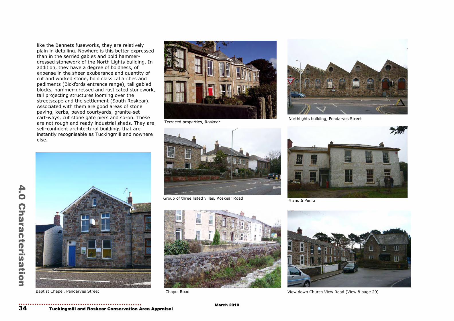
like the Bennets fuseworks, they are relatively
plain in detailing. Nowhere is this better expressed than in the serried gables and bold hammer-
dressed stonework of the North Lights building. In addition, they have a degree of boldness, of
expense in the sheer exuberance and quantity of cut and worked stone, bold classical arches and
pediments (Bickfords entrance range), tall gabled blocks, hammer-dressed and rusticated stonework,
tall projecting structures looming over the streetscape and the settlement (South Roskear).
Associated with them are good areas of stone paving, kerbs, paved courtyards, granite-set
cart-ways, cut stone gate piers and so-on. These are not rough and ready industrial sheds. They are
self-confident architectural buildings that are
instantly recognisable as Tuckingmill and nowhere else.
Chapel Road
4 and 5 Penlu
Northlights building, Pendarves Street
Baptist Chapel, Pendarves Street
Group of three listed villas, Roskear Road
View down Church View Road (View 8 page 29)
Terraced properties, Roskear
March 2010

Tuckingmill and Roskear Conservation Area Appraisal 35
4.0 Characterisation
March 2010

36 Tuckingmill and Roskear Conservation Area Ap-
5.0 Issues and
Opportunities
Boundary of the Conservation Area
5.0 Issues and Opportunities
The Conservation Area was designated in
September 2004 and has not been extended since. There appear areas, however where
amendments to the current boundary appear justified. These are indicated on the map and
justification for these proposed extensions is given in Appendix 1.
Street schedule
The Conservation Area covers the following streets (in their entirety unless specified):
Bartle’s Row (excluding 1a, 2a, 3a, 4a) Chapel Close
Chapel Road Church View Road: 30-54 (even), 51-75, (odd);
community centre (old school)
East Hill; nos.1-12 Edward Street
Hensley Row Mayne’s Row
North Roskear Road: 82-100 (even), 189-203 (odd)
Pendarves Street Pengellys Row
Penlu Primitive Row
Rear of Edward Street Rear of Pendarves Street
Rose Cottages Roskear: 16-40 (even), 21-57 (odd); Wanga
House; All Saints church and churchyard
South Roskear Terrace
Tolgarrick road: nos. 1-9
Buildings at Risk
Tuckingmill contains a number of historic buildings in various states of neglect. They remain
important historic buildings which reflect the historical development of the area and are worthy
of preservation and conversion. These are indicated on the following map and include the
following buildings:
RT10 - Industrial Buildings, South Roskear (Lidl) RT12 - Industrial Buildings Group, West Side of
South Roskear Terrace RT7 - Northlights Building
RT8 - Old Fuse Works (rear building of
Northlights) RT3 - Old Fuse Works
RT6 - Methodist Chapel, Chapel Road RT1 - Old Workshop, North Roskear Road
No.89 Pendarves Street Hirst House, Chapel Road
Northlights building, Pendarves Street
March 2010

Tuckingmill and Roskear Conservation Area Appraisal 37
5.0 Issues and Opportunities Opportunity / Gap Sites and Buildings at Risk
Potential Extensions
March 2010

38 Tuckingmill and Roskear Conservation Area Appraisal
5.0 Issues and Opportunities
Negative Buildings B.EN11: development will be permitted in the Conservation Area if it respects the scale, height,
massing, alignment and design character of the area; where it preserves existing heritage or
architectural features; where it incorporates local building styles or materials; and where it preserves
and enhances the character and appearance of the Conservation Area (other than in exceptional
cases). The setting of the Conservation Area is also recognized as being important in this respect.
B.EN12: Demolition will be permitted where the
structure to be demolished makes no significant
contribution to the character or appearance of the area and detailed proposals for the re-use or
redevelopment of the site have been approved.
Although, in many cases, these negative buildings
are in good condition and productive use, works to these buildings present opportunities to render
them more in keeping with their neighbours. Demolition is encouraged where the replacement
building would make a positive contribution to the character and appearance of the Conservation Area
or its setting.
Gap/opportunity sites Planning Policy Guidance 15, para. 4.17:
Many Conservation Areas include gap sites, or buildings that make no positive contribution, or
indeed detract from the character and appearance of the area: their replacement should be seen as
an opportunity to enhance the area. What is important is not that new buildings should imitate
earlier styles, but that they should be designed with respect for their context, as part of a larger
whole which has a well established character of its own.
The Conservation Area Appraisal identified a
number of buildings which detract from the character and appearance of the Conservation
Area, as well as ‘gap’ and opportunity sites which could productively be redeveloped. These gaps are
often ‘tears’ in the fabric of the townscape, and to fill these would improve the sense of enclosure
and quality of the townscape.
There is also an opportunity for increased use (and possibly LOTS type schemes) of the interesting
outbuildings, workshops and yards that are important to the Conservation Area’s character.
Back Lanes, alleys etc. are unique streetscapes,
often an important aspect of the character and
setting of principal streets, but also of exceptional importance in themselves; here buildings and
informal streetscapes directly preserve historic layout and grain or archaeological sites, and
sometimes contain amongst the oldest buildings in the Conservation Area, often with significant
histories, textures and fabric of their own. Erosion or loss of these buildings could result in a similar
poverty of townscape as already exists in some streetscapes where wholesale demolition has
taken place.
PRINCIPLE: The Local Planning Authority should where possible and practicable promote the
redevelopment of gap and opportunity sites, and the enhancement/replacement of buildings
deemed in the Appraisal to make a negative contribution to the quality of the Conservation
Area in accordance with policies set out in the relevant Local Plan and in national planning
guidance.
The English Heritage/CABE document Building in context: new development in historic areas should
be used as a particular guide to the appropriate approach. In this respect, designs should follow
the principles for the character areas set out in the
Appraisal without necessarily being pastiche. They should reflect the historic urban grain, respect
important views, and should be inspired by the proportions, massing and materials of surrounding
historic buildings. A high-quality, thoughtful approach is needed: it is not enough simply to
randomly apply historic details, or to use modern stone facing panels separated by mastic expansion
joints.
New developments should add to the variety and texture of the Conservation Area.
Tuckingmill and Roskear have quite a few poorly
maintained historic buildings but in terms of architectural design have relatively few negative
buildings. A map showing negative buildings is included on page 27. The negative buildings
comprise:
RT24 Depot, Pendarves Street (Speedy Hire) Chapel Court, Edward Street
103 Pendarves Street Endsleigh House, Roskear
March 2010

Tuckingmill and Roskear Conservation Area Appraisal 39
5.0 Issues and Opportunities
Sustainability Climate change is probably the greatest long-term challenge facing the human race, and the UK
Government has made a number of commitments to reduce carbon emissions, which are believed to
contribute to climate change. Current targets are to reduce carbon dioxide emissions by 20% (of
1990 levels) by 2010, and by 60% by 2050.
Operational energy in buildings (to heat, ventilate and light them, etc) accounts for 46% of the UK’s
carbon dioxide emissions, and so in order to meet these targets it is critical that every household and
business take measures to reduce energy use in
their buildings. Part L of the Building Regulations came into force in 2002 and seeks to improve the
energy efficiency of buildings. There are also progressive targets for carbon emissions from the
construction and operation of new buildings (Ecohomes and Code for Sustainable Homes).
Building Regulations Part L1.
Sections 2.9 - 2.11
2.9 Historic buildings include -
a) listed buildings.
b) buildings situated in conservation areas.
c) buildings which are of architectural and historical interest and which are referred to as
a material consideration in a local authority’s development plan.
d) buildings of architectural and historical
interest within national parks, areas of outstanding natural beauty, and World
Heritage Sites.
2.10 The need to conserve the special characteristics of such historic buildings needs to
be recognised. In such work, the aim should be to
improve energy efficiency where and to the extent that it is practically possible, always provided that
the work does not prejudice the character of the historic building, or increase the risk to the long-
term deterioration to the building fabric or fittings. In arriving at an appropriate balance between
historic building conservation and energy consumption, it would be appropriate to take into
account the advice of the local planning authority’s building conservation officers.
However, there is a risk that measures to improve
the energy efficiency of historic buildings could damage or destroy their historic and architectural
significance. For example, the installation of renewable energy equipment on buildings, such as
wind turbines, solar water heating and photovoltaic cells, could have an adverse effect on
the Conservation Area. There is also the perception that uPVC windows are more energy
efficient (the sustainability of uPVC windows is a complex issue and is discussed further on page
xx), but the installation of these is usually detrimental to the character and appearance of the
Conservation Area. Therefore, historic buildings are exempt from the application of Part L where it
would threaten their special character, as
described in the inset. That said, a balance needs to be struck, and it is important that the local
authorities, residents and businesses make serious efforts to reduce carbon emissions.
Recommendations of how this might be achieved are set out in the management strategy section
(page 60).
Photovolaic cells on a historic church, Germany
March 2010

40 Tuckingmill and Roskear Conservation Area Appraisal
5.0 Issues and Opportunities
Opportunity / Gap Sites and
Negative Buildings
March 2010

Part Two
Management Strategy
Part Two Management Strategy
Tuckingmill and Roskear Conservation Area Appraisal 41 March 2010

42 Tuckingmill and Roskear Conservation Area Appraisal
Two Part Management Strategy
March 2010

Tuckingmill and Roskear Conservation Area Appraisal 43
6.0
Introduction
6.0 Introduction to the Management Strategy
This Management Strategy develops the findings
of the Appraisal to consider how best the special character of Tuckingmill and Roskear Conservation
Area can be protected and enhanced. It begins with an outline of the strengths, weaknesses,
opportunities and threats facing the Conservation Area. The second section then considers how the
character and appearance of the Conservation Area could be enhanced, referring to general and
specific issues. The third section sets out ways in which the Conservation Area is and can be
protected by statutory and local means. The final section considers how this plan can be
implemented, who will be responsible for it, and how it should be funded.
Although some of the action points are particularly relevant to the local authority, the strategy is
intended for everyone who lives or works in the Tuckingmill-Roskear Conservation Area, as well as
those who visit it. Like the Appraisal, it is the product of local consultation and discussion. It is
intended as a practical, achievable document, not a set of empty aspirations.
Listed villas, Roskear
View down North Roskear Road with Northlights building in foreground and South
Crofty Mine in background
March 2010

44 Tuckingmill and Roskear Conservation Area Appraisal
7.0 Srengths, weaknesses, opportunities & threats
The following broad swot analysis considers some
of the strengths, weaknesses, opportunities and threats in Tuckingmill and Roskear from a
conservation and urban design viewpoint. It is not an economic, regeneration or urban health check
analysis.
Strengths • Many historical buildings linked to the region’s
industrial past remain and are of a good, robust quality. There is a good mix and
variety of historical buildings and, although many buildings do not retain original windows
and doors, a sense of the area’s industrial importance remains.
• The retention and re-use of the former industrial complexes (Bennets/ Bickford-
Smiths) has provided a good mix of small, medium and large businesses and employers
providing an economic base for further commercial activity.
• Within much of the Conservation Area trees,
gardens and landscapes of high quality are as prominent as houses.
• There is an attractive residential hinterland – the impact of the busy road is only one plot
deep and streets away from the main road are surprisingly quiet and secluded. Parks,
sports grounds and informal recreation areas (including the urban park made out of old
industrial wastelands) are all within easy access.
• There is a good range of community facilities – shops, doctor, school, sports facilities,
church/chapels, community centres and a range of shops (including supermarket) and
commercial premises offering local services as
well as some serving wider markets.
7.0
Strengths, weaknesses, opportunities & threats
• Property values are still relatively low. • There is good access to main roads (A30) and
major retail, educational and cultural facilities (Pool). There is plenty of on-street parking
and the area is on a main bus route. • There are likely to be a number of high profile
future development opportunities in the area, through Camborne-Pool-Redruth regeneration
initiatives. • Existing businesses serving a wide area are
already drawing trade from a broad catchment area – Tuckingmill is known for
certain specialist suppliers giving a ready-made commercial image to build upon.
• Despite competition from adjacent major
retail centres, the increasing local residential population should stimulate local shops and
services, which could be targeted and grant-aided for re-location here.
• There is evidence of recovery in the wider community in recent years.
Cornwall Council has a proven track record in
obtaining and effectively managing heritage-based grant schemes (for instance in Redruth where such
schemes have proven the most effective catalyst for regeneration).
Weaknesses
• Low property values conversely make for poor Investment potential and indicate marginal
economic activity. A low income base could result in match funding difficulties for future
grant aided work.
• There has been a long-term under
appreciation of the high quality and significance of the remaining historic fabric,
espe cially on commercial properties. The historical, archaeological, landscape and
amenity value of remnant agricultural and industrial land are all too often seen just as
opportunity development sites. • Long-term deprivation and recession has left a
legacy of under-investment and lack of repair/ restoration in many properties.
• There are many traditionally detailed buildings, surviving in more-or-less complete
condition, particularly the industrial complexes. These present a considerable
challenge in terms of funding, policies on
change of use and conservation management, and the design of suitable alterations and
adaptations. • Sources of additional employment within
Tuckingmill are limited and sources of employment/spending power within
Cam borne-Tuckingmill are still below average levels.
• The main through road is very busy with limited pedestrian areas and brutal traffic
calming/management schemes. Access onto and over the main road from the side streets
is very difficult for local traffic. • Noise and fumes from traffic are a problem for
properties fronting the main road.
• The position of Tuckingmill close to major retail centres (Tuckingmill-Roskear and Pool)
makes major commercial investment unlikely. • Poor management, maintenance and
accessibility of some key buildings in the area.
March 2010

Opportunities • A Townscape Heritage Initiative scheme
commenced in Camborne, Tuckingmill and Roskear in January 2008 and will run until
January 2013. The scheme offers grants for traditional repairs to targeted historic
buildings within the Conservation Area. A number of the key targets are in Tuckingmill
and Roskear and include redevelopment
schemes on ‘iconic’ vacant and underused industrial sites.
• There is potential for a streetscape audit, public realm improvements scheme, traffic
management review and landscape management agreements.
• Development opportunities exist on adjacent derelict open lands.
• Many of the industrial sites in Tuckingmill are key components of the Cornish Mining World
Heritage site. There is an opportunity for promotion and interpretation of the remaining
industrial buildings in the area. There is also the opportunity of exciting conversion
schemes in some of the remaining former
industrial buildings. • There is an opportunity to make the best use
of those special features of the settlement that survive to create a sense of place and
local distinctiveness, perhaps especially the stock of unused or underused shops,
commercial premises and industrial buildings. • An opportunity exists to upgrade the existing
housing stock. • Green, fields, open spaces, playing fields, Red
River valley (south of the A3047 as well as the urban park north of it) create unique
opportunities for a garden city environment, an opportunity to create a rare green urban
environment of the very highest amenity
value for residents • Traffic reduction on Pendarves Street through
implementation of major schemes bid ena-bling environmental, pedestrian and cycling
improvements.
• Improved access to and interpretation of key
community and heritage assets on brownfield land, Red River and Bickford Smith range
through regeneration proposals in Tuckingmill Framework.
• New uses, repair and conversion of key build-ings including Northlights building and
Bickford Smith range as part of wider regen-eration masterplans.
• Strategic link between Pendarves Street and proposed East-West link giving access to
brownfield land to rear for development.
Threats A lack of appreciation of the areas historical
quality and importance could lead to: • A lack of maintenance and neglect of its
historic fabric. • Loss of historic fabric, poor alterations.
• Unsympathetic conversion of historic buildings.
• Loss of archaeological evidence. • Loss of interpretative, celebratory and
promotional opportunities. • Loss of greenery and gardens (especially
forecourts-loss of enclosure and provision of hard standings).
• Loss of back street areas.
• Threats are most likely to result from failure
of future development, and regeneration schemes, to recognise Tuckingmill’s special
and locally distinctive industrial character. • Development in surrounding areas could
marginalise Tuckingmill and Roskear. Uncoordinated, small-scale and piecemeal
proposals could also seriously affect the historic character and current quality of the
local environment. • It is important to protect quality vacant and
underused historical buildings against demolition to prevent loss of character and
spirit of place.
• The recent loss of the post office has
removed a major element in drawing trade to the local shops.
• Surviving areas of paving should be retained and used as a reference for future public
realm schemes. The main streets are traffic dominated and efforts should be made to
increase ease of pedestrian movement. • Care should be taken to retain historic shop
fronts and efforts should be made to ensure that any residential conversion of a shopfront
retains the original shopfront and is reversible. Loss of original shopfronts will be
harmful to the character of the Conservation
Area.
Tuckingmill and Roskear Conservation Area Appraisal 45
7.0 Srengths, weaknesses, opportunities & threats
March 2010

8.0
Enhancement
46 Tuckingmill and Roskear Conservation Area Appraisal
8.0 Enhancement
This section looks at how the character and
appearance of the Tuckingmill-Roskear Conservation Areas could be enhanced. English
Heritage’s Guidance on the Management of Conservation Areas states that enhancement can
take two principal forms:
- the sympathetic redevelopment of sites defined in the detailed Appraisal of the area as detracting
from its character or appearance
- pro-active proposals, such as the management and repair of a designed historic landscape, a
scheme for the restoration of distinctive architectural features or traditional shop fronts,
the reinstatement of historic surfaces, or the
reduction of traffic intrusion and the rationalisation of street signage.
The action points set out within this section have
been developed with the English Heritage guidance in mind. The first part of the section deals with
general themes, applicable to the whole Conservation Area but illustrated with specific
examples. The second part then gives specific action points applicable to smaller sub-areas
or streets.
General guidance
Public realm Streets and open spaces, collectively known as the
public realm, are a major factor in the character of the Conservation Area. Care should be taken in
the case of any essential maintenance/repair works, so that the public realm is not degraded.
This will involve the various local authority departments who may be responsible for the town,
as well as the utility companies, private
contractors, and property owners. All proposals
affecting the public realm should be developed with reference to key guidance documents, such
as:
- Streets for All: South West (English Heritage, 2005)
- Paving the Way (CABE, 2002)
For the purposes of this management plan, the public realm has been divided into the following
categories: paving, signage, lighting, street furniture, the kennels, and planting.
Paving
The Conservation Areas retain small areas of
historic paving that are worthy of retention. Robust granite kerbs to pavements and granite
slab threshold are historically consistent with the industrial area. These still exist and should be
replicated in future public realm schemes.
PRINCIPLES: There should be a presumption in favour of the retention of historic paving materials
within the Conservation Area – predominantly granite kerbstones. As opportunities arise, there
should be a presumption to restore historic local materials that have been lost in key public spaces
and streets.
When traditional materials are reinstated, they should be of the same size unit as historic
examples, where possible.
Where interventions are required to meet current
Disability/Health and Safety legislation (e.g. studded pavements at crossings), these should be
carefully designed so that they do not compromise or result in the loss of historic street paving/
kerbstones, and so that their design complements and enhances their surroundings. Areas suffering
from a degraded public realm should be upgraded as a matter of priority.
Within areas that do not have an obvious historic
character, a contemporary but limited palette – suitably distinguished from but also compliment
the historic materials palette – could productively be deployed.
Care should be taken that essential road works do
not compromise or degrade the public realm and that surfaces are correctly reinstated upon
completion. Where posts and signs have to be set into the pavement, slabs should be re-cut
where possible to accommodate them: concrete or tarmac patches are not appropriate. The Local
Planning Authority should make maximum use of its powers under the New Roads and
Streetworks Act to inspect works by utility
companies and to apply financial penalties in cases where reinstatement is inadequate.
The Local Authority should provide a repair and
maintenance programme for materials that are damaged or have missing elements.
ACTION: Consideration should be given to the
production of a manual for streetscapes in the historic areas of the town.
March 2010

Tuckingmill and Roskear Conservation Area Appraisal 47
Signage
Signage can be divided into the following
categories: street nameplates, pedestrian wayfinding, and traffic management signs.
The majority of street signs are relatively modern
plastic items, mounted on posts. The current style of street sign, though not overtly historic in its
materials, does not detract from the character of the Conservation Area. Nonetheless, care should
be taken that any future re-design of these items is similarly sympathetic to the prevailing character
of their setting and that standard items are not uncritically applied. The location of signs should be
carefully considered: where they can be mounted
on walls without damaging the character or fabric of historic structures, this would be better than
free-standing units.
PRINCIPLE: Where traffic management signs are necessary, they should be integrated into single
units or onto existing lamp posts, railings, or bollards where possible. Careful consideration
should be given to an integrated strategy which avoids the use of unnecessary signs or street
markings where other, less intrusive measures could be taken.
ACTION: An integrated wayfinding policy should be
developed. Attention should be given to
maintaining the wayfinding system so that it is up-to-date, and to remedy any issues caused by
vandalism.
Advertisements
Shop signs in Tuckingmill and Roskear often
detract from the appearance of the Conservation Areas. The Council has a shopfronts design guide
along with specific guide on the historical development and appearance of shops in
Tuckingmill. There is a need for further guidance and planning policy on advertisements.
PRINCIPLE: Provide stronger policy guidance on advertisements and provide further design
guidance on signage and lighting.
8.0 Enhancement
Lighting
Street lighting is fairly standard and appears
cluttered and intrusive on the main streets.
PRINCIPLES: New street lighting should reflect the
distinctive local character of local historic lamp units: standard catalogue fixtures of the sort which
could be found anywhere in the country should be discouraged.
The size and scale of street lighting fixtures should
respond to the height of the surrounding buildings. Tall structures which tower above the street should
be discouraged, even if they are of ‘historic’
appearance. Where possible, fittings should be incorporated into the existing fabric, perhaps using
wall mountings (subject to the appropriate consents), but should be designed to avoid
damage to historic buildings as well as being appropriate in scale.
Street furniture
The effective use of street furniture presents the opportunity to create a lively, attractive public
realm. There could be changes to the public realm through potential future redevelopment schemes
and a good opportunity exists to review and
improve existing street furniture. Safety measures such as the crash barrier balustrades up East Hill
are particularly intrusive and do nothing for the character of the area.
PRINCIPLES: The provision of benches, railings,
litter bins, railings, bus shelters, and other essential items of street furniture should form part
of an integrated public realm strategy in which the design (form and colour scheme) of such items is
co-ordinated with street lighting and paving. They should reflect the historic character and
appearance of the Conservation Areas. Where necessary and possible, the Local Authority should
encourage property owners to improve privately-
owned public spaces in a similar fashion.
Standard catalogue items should be avoided in
favour of designs which echo (and re-interpret) local traditions and which complement their
setting.
Care should be taken that new street furniture does not create intrusive visual ‘clutter’. The
impact of such items on views along the street and on the setting of the Conservation Area and its
buildings should routinely be considered. An excess of commercial advertisement on street furniture –
such as bus shelters – should be avoided.
Traffic calming
There is an obvious need for traffic calming in
Pendarves Street but, perhaps, a more sympathetic solution could be sought to the
current one which is a bit severe. The main roads are very busy and pedestrian access is very
restricted. Improved pedestrian access and cycling provision would be a huge benefit to the area.
PRINCIPLE: Any future traffic calming measures
deemed necessary should be custom-designed to respect the character and appearance of the
Conservation Area. Speed reductions, for example, can often be achieved through the strategic
deployment of surface materials such as brick.
March 2010

48 Tuckingmill and Roskear Conservation Area Appraisal
8.0 Enhancement
Planting and green space
Boundary walls, hedges and trees have importance
to the Conservation Area and provide a pleasant green backdrop. The Importance of greenery to
backland areas and rear lanes is an attractive feature which should be protected.
PRINCIPLES: Improvements to the existing green
spaces within the Conservation Area should be encouraged.
Landscaping and tree and planting management
schemes should be developed. especially where there is a significant impact on character and
appearance (Penlu; Tuckingmill churchyard; Wanga House, the Roskear houses, 97 & 99
Pendarves Street, Tolgarrick; Eton House, Bartles Row, 30 Church View Road, and Church View
Farm). Investigate public-private partnerships to
subsidise and manage planting for front gardens etc. (schemes are currently operated by Cornwall
Council under certain regeneration programmes).
Street-tree planting schemes should be investigated in a wider context with appropriate
species and detailing. The backland areas and rear lanes of Tuckingmill-
Roskear should be recognised as an important aspect of the character and appearance of the
Conservation Area, and their informal qualities enhanced, the trees and open spaces to be
managed to enhance that character and appearance.
ACTION: A full survey should be undertaken of
existing trees and ornamental landscapes. The survey should include management proposals
to ensure that existing trees of merit are maintained.
Views
Views and vistas of Tuckingmill are dominated by
the brooding presence of South Crofty tin mine. The main Camborne Redruth road cuts through the
centre of the Conservation Area and Tuckingmill in particular is clearly visible from the A30.
PRINCIPLE: The possibility of further architectural
lighting should be considered where this would enhance night-time views.
ACTION: The Local Planning Authority should
protect and manage the significant strategic and street views noted within the Conservation Area
Appraisal, and should include these views within the Local Development Framework. New building,
street furniture, and other developments should have regard to their impact on such views. English
Heritage’s Seeing the history in the view: a method for assessing heritage significance within
views should form the basis of such assessments.
Traffic and movement
The Conservation Areas are split by the central main road from Camborne to Redruth. The road is
busy and pedestrian movement is extremely
restricted.
Increasing car use has had a significant effect on traffic and movement through the areas and has
put pressure on roads which were not originally designed for motorised traffic. In many towns, one
of the biggest threats to the quality of Conservation Areas is not the way in which
buildings are treated, but rather the negative effects of traffic and parking. The issue is to find
the best balance between vehicles and the quality of the place that they serve.
The new road proposals in the area will bring some longer term benefits to the A3047 and conserva-
tion led regeneration on some key sites outlined in
the Tuckingmill Framework.
PRINCIPLE: Traffic management and parking proposals should be devised to help enhance the
character of the town centre streets, This goal may partly be achieved through the retention or
reinstatement of historic surfacing materials and layouts as a means of traffic calming. Alterations
should be undertaken carefully so that they do not compromise the legibility of the historic built
environment: e.g. some separation between road and pavement should be maintained.
March 2010

‘Increased occupation of underused commercial
buildings through LOTS-type schemes would help rejuvenate many historical buildings and bring
vitality back to the centres. There is also an oppor-tunity for increased use (and possibly LOTS type
schemes) of the interesting outbuildings, work-shops and yards that are important to the
Conservation Area’s character.
ACTION: The Local Planning Authority should where possible and practicable promote the
redevelopment of gap and opportunity sites, and the enhancement/replacement of buildings deemed
in the Appraisal to make a negative contribution to the quality of the Conservation Area in accordance
with policies set out in the relevant Local Plan and
in national planning guidance.
The English Heritage/CABE document Building in context: new development in historic areas should
be used as a particular guide to the appropriate approach. In this respect, designs should follow
the principles for the character areas set out in the Appraisal without necessarily being pastiche. They
should reflect the historic urban grain, respect important views, and should be inspired by the
proportions, massing and materials of surrounding historic buildings. A high-quality, thoughtful
approach is needed: it is not enough simply to randomly apply historic details, or to use modern
stone facing panels separated by mastic expansion
joints. New developments should add to the variety and texture of the Conservation Area.
Building maintenance
The focus of Conservation Area measures is on
times of change– proposals to develop or alter buildings, or to change the landscape and
planting. However, the quality of a Conservation Area depends as much on everyday care and
maintenance: whether the footways are weeded, gutters and drains cleared; old notices removed
and buildings repaired. People generally recognise the need to redecorate their houses or premises,
but they often feel less responsible for the public
face of their buildings and the streets where they stand.
Tuckingmill and Roskear Conservation Area Appraisal 49
8.0 Enhancement
Although measures such as the THI grant scheme have been useful in addressing the question of
maintenance and enhancement through targeted interventions to improve particular buildings,
community action can also reap rich rewards, particularly in residential areas. Elsewhere in the
country there are useful examples of grassroots schemes for street improvements, such as the DIY
street projects managed by SUSTRANS. The aim is for individual building owners to look after their
buildings and to help people to become involved.
PRINCIPLE: Within the centre, funding could be sought or allocated for an annual ‘spring clean’ to
clear and mend gutters, remove unwanted
posters, wires etc., and to alert owners to maintenance problems.
The involvement of local community and trade
organisations should be sought where possible. In other towns the local fire service has been
deployed to help clear gutters as a joint PR exercise; this could be repeated to good effect in
Tuckingmill and Roskear.
ACTION: In residential areas, the Local Planning
Authority should encourage residents to carry out collective maintenance of their properties and
common areas. A leaflet outlining possible
collective DIY measures, including practical advice, would be an incentive for that line of action.
Guidance should also be produced on the benefits
of retaining original garden walls, gates and rail-ings as well as how best to facilitate sustainable
drainage. The latter is relevant to overpaving green garden areas and removal of garden walls.
Commercial
Historical shopfonts to existing commercial units
should be retained in line with the Tuckingmill Shopfront Guide.
Residential
Any new housing in the Conservation Area should be of a high quality utilising local materials where
possible and be designed in a manner that reflects the character of historical buildings in the
Conservation Area. New housing in the Tuckingmill South area will bring extra footfall and customers
to support local facilities and the use of historic buildings in the central Tuckingmill area.
PRINCIPLE: Proposals to provide residential accommodation in the upper floors of historic
properties should be encouraged where possible. Such buildings may form a particularly
attractive and cost-effective solution to the issue of affordable housing provision. Disused buildings and
those at risk should be considered for residential conversion. The development of vacant sites in the
town should encompass a mix of uses, including residential.
Uses
The various gap sites identified in the Appraisal
within the town offer some scope to introduce new
uses or to expand Tuckingmill’s retail and commercial provision. Elsewhere, the introduction
of new uses should be integrated within the existing building fabric and should take advantage
of the opportunities posed by the town’s historic building stock.
Gap’ and opportunity sites, negative
buildings
The Conservation Area Appraisal identified a number of buildings which detract from the
character and appearance of the Conservation Area, as well as ‘gap’ and opportunity sites which
could productively be redeveloped. These gaps are
often ‘tears’ in the fabric of the townscape, and to fill these would improve the sense of enclosure
and quality of the townscape.
March 2010

50 Tuckingmill and Roskear Conservation Area Appraisal
8.0 Enhancement
Map showing main
transport routes
March 2010

Tuckingmill and Roskear Conservation Area Appraisal 51
8.0 Enhancement
Public appreciation and tourism
Tuckingmill & Roskear fall within the Camborne
Pool Redruth Area where a key partner is the Urban Regeneration Company (URC), Camborne
Pool Redruth Regeneration. It is important that the historical significance of the Conservation
Areas are fed into all major emerging development proposals in these areas. The importance of
heritage led regeneration in these areas should not beoverlooked and the production of design briefs
for major schemes within the Conservation Areas should be encouraged to raise awareness of the
significance of both areas.
The Council has already adopted supplementary
planning guidance in the ‘Building Design Code for the Camborne-Pool-Redruth Area’ which is derived
following public consultation on the Urban Framework Plan and extensive consultation with
community groups.
Some degree of change is inevitable in Conservation Areas and the issue is often not so
much whether change should happen, but how it is undertaken. Owners and residents can minimise
the negative effects of change by employing skilled professionals when preparing development
proposals and by avoiding unrealistic aspirations.
PRINCIPLE: The Local Authority will ensure that
information on the historical significance of an area is readily available and easily accessible in order to
work with local communities.
The Local Authority will take steps to explain its planning decisions where they are contrary to the
advice of town and parish councils.
ACTION: The Local Authority will ensure that planning and development briefs are produced for
all major development schemes in Tuckingmill & Roskear Conservation Areas.
The role of Historic Environment Champions
English Heritage is keen to see Historic
Environment and Design Champions promote conservation and design issues in each local
authority. These are preferably elected councillors, but can be senior officers.
PRINCIPLE: The Local Authority will continue to
support the roles of the Historic Environment and
Design Champion and provide training opportunities for them.
Historic architectural detailing
There still remains a good selection of historic
buildings within the Conservation Areas with a decent survival rate of original architectural
features. However, replacement roof tiles and windows have damaged the character of some
properties, while replacement soffits and other details have resulted in the loss of historic fabric.
ACTION: Historic architectural details (as discussed
in the Appraisal) are to be retained. These may
include: sash windows (see also below), stone detailing, elaborate porches, slate hanging, carved
gable-end details, historic front walls, four/six-panelled doors on Victorian properties, vertical-
panelled doors to cottages, and chimneys. If replacement is essential, this should match the
original as closely as possible in terms of material, style, colour and form.
Stonework should not be painted or rendered
except where this is already the case.
Where roofs are replaced, a close match with the existing materials should be found. Generally this
will mean slate. Metal clip fixing should be avoided.
Chimneys should be retained. Blocked, capped and
removed chimneys not only detract from the
appearance of the Conservation Area but also can lead to internal damp/ventilation issues. Article 4
directions should be enforced to protect historic features.
The back areas of properties are often the oldest
part of historic buildings and wholesale changes to these areas should be resisted. Some rear areas and
frontages to properties in Roskear are at risk through curtilage parking.
ACTION: The Local Authority should look carefully at
proposals to demolish rear walls and outbuildings and discourage the creation of parking areas within front
gardens. Where possible it should not implement new
policies towards street parking which would stimulate the further loss of front gardens.
Skills training and funding initiatives should be investigated for the repair and retention of traditional
boundary walls, gates and railings.
Windows, gutters, and rooflights Well-intentioned works, such as the replacement of
degraded historic windows or gutters with uPVC items, can often damage the character and
appearance of a Conservation Area whilst – in the longer term – being environmentally unsustainable.
Within the existing Conservation Area, a good number of original sash windows survive on
commercial buildings although there have been some
replacements in the case of residential properties.
ACTION: The Local Planning Authority should prepare a leaflet outlining the benefits of sash window repair
and refurbishment as a practical, efficient, sustainable and character-retaining alternative to
uPVC replacements.
Where skylights are required as part of loft conversions, these should be located on rear or side
elevations, and should be of traditional design.
Article 4 directions removing permitted development rights should be implemented and enforced.
March 2010

8.0 Enhancement
52 Tuckingmill and Roskear Conservation Area Appraisal
Key development sites
The URC commissioned an Urban Framework Plan
for Camborne, Pool and Redruth to guide the regeneration of these towns between 2001 and
2011. It identified 23 projects that could potentially receive EU funding; some of these sites
were within and around the Conservation Areas.
An Urban Framework Plan for Camborne, Pool and Redruth 2001 – 2011 identified a number of site
regeneration opportunities in the area and poten-tial to access EU funding. Site opportunities were
consulted on and subsequently rationalised through the CPIR Area Action Plan process in 2008
and 2009 which proposes a number of strategic
site allocations in the area.
Significant sites in the Tuckingmill area include:
Tuckingmill (H6 / H7) East Hill Gateway/Trevenson Park West (M2)
Dudnance lane (M1) Boiler Works Road (H2)
Part of the Tuckingmill site (H6/H7) is within the
Conservation Area while the others are adjacent or nearby to the Conservation Area. All of the sites
are subject to masterplans, design briefs and or site framework plans.
The EU Objective One funding programme has ended although opportunities remain through the
Convergence Funding programme until 2013. The public and private sector are involved in bringing
forward the schemes in the Tuckingmill area - in particular site frameworks for the Tuckingmill (H6 /
H7) site and the Dudnance Lane (M1) site are expected early 2010 and will provide further
guidance for development as set out in the emerging AAP.
Camborne, Roskear and Tuckingmill
Townscape Heritage Initiative (THI)
The THI commenced in January 2008 and will run until January 2013 with a grant expiry date of
January 2011. The scheme funds quality traditional repairs to targeted historic properties in each
Conservation Area.
ACTION: The Local Authority should continue to support and promote the THI.
Photographic library
As part of the THI management archive
photographs and maps are being compiled to
inform future schemes. This process could be maintained beyond the THI to highlight the historic
importance of the areas.
ACTION: Maintain photographic library of area.
Town Centre Health Checks
In 2004 the Council and URC produced a retail study
for the Camborne Pool Redruth area and the rest of the district. This provided valuable base-line informa-
tion about the trading position of the centres, their inter-relationships and the threats and opportunities
for the future. The study showed that a significant amount (approximately 70%) of comparison goods
trade is lost from the towns to other centres. It shows the urgent need to address this trade diversion and
claw back some lost trade and raise market share. There is also much pressure to convert existing shops
into residential accommodation, which, if imple-mented, will affect the balance and appearance of the
streetscene.
ACTION: The Local Authority will regularly update the
retail study and pursue schemes to address any identified problems.
March 2010

Tuckingmill and Roskear Conservation Area Appraisal 53
8.0 Enhancement
Archaeology and
Historic Settlement
There are two principal aspects to the
archaeological potential of the conservation area. Firstly, deposits around the Tuckingmill/Tolgarrick
core and around Roskear farm and town-place may yield information about medieval, and
possibly Iron Age or earlier origins, elements of which underpin the current morphology, character
and indeed appearance of these areas.
A second strand of archaeological potential lies in the significant industrial remains. Evidence may be
available in the archaeological record within and
around the conservation area of all phases of development of mining from the earliest prehis-
toric exploitation, through medieval tin streaming to 19th century deep mining, as well of the various
phases of 19th century industrial process(fuseworks, iron foundries). Some fairly detailed
investigation has taken place, particularly of standing buildings, at Bickford-Smith’s and South
Roskear; but these have not been exhaustive, and other sites have received much less attention
(Bennets), with little below-ground investigation anywhere. Reference should be made to studies by
Cornwall Archaeological Unit and others for full details.
It cannot be assumed that all sites of archaeological potential in the settlement have
already been identified (for instance in the County Historic Environment Record), even those
completely new streets laid out on mainly agricultural land (especially Edward Street and
Pendarves Street) also exploited old mining wastes (there is some evidence that the line of Pendarves
Street was in part determined by an older linear series of mine shafts and waste dumps). The
earlier settlement cores (Tuckingmill/Tolgarrick and Roskear) may have surprisingly complex
deposits, and surviving structures and landscape features in those areas may contain significant
archaeological evidence.
The importance of the historic and archaeological
character of the conservation area is already recognised by existing designations:
the local list of settlements and villages of
historic origin (paragraphs 4.33-4.38 of the Local Plan)
target historic settlement for CISI the whole historic settlement, as defined by
the 2002 CISI report is within the World Heritage Site for Camborne-Redruth
This adapts existing Policy ENV9 (tree Preservation
orders) to relate to all trees in the conservation area to indicate when a TPO is likely to be made.
In order to preserve the important contribution to character and appearance of the often large
gardens, grounds and historic plots within the Conservation Area, the retention of such spaces
may require reductions in other standards, such as parking, or a flexible approach to housing
development densities.
Back Lanes, alleys etc. are unique streetscapes, often an important aspect of the character and
setting of principal streets, but also of exceptional importance in themselves; here buildings and
informal streetscapes directly preserve historic layout and grain or archaeological sites, and
sometimes contain amongst the oldest buildings in
the Conservation Area, often with significant histories, textures and fabric of their own. Erosion
or loss of these buildings could result in a severe poverty of townscape.
March 2010

8.0 Enhancement
54 Tuckingmill and Roskear Conservation Area Appraisal
World Heritage Site Implications
The Tuckingmill and Roskear Conservation Area is
within the World Heritage Site area. This has implications for historic settlement status and
archaeology. There are further implications for individual sites and buildings types.
The World Heritage Sites (including the whole of the Conservation Area) are a material
consideration in the spatial planning process and are referred to in PPG15 (paragraphs 2.2.2-3).
The World Heritage Site description does not preclude further designation of individual sites ,
nor does it assume that all such sites have so far been identified. Specific sites and building types
which are of importance to the whole WHS framework have been identified here.
PRINCIPLE: World Heritage Sites will be a key
material consideration to be taken into account in determining planning and listed building
applications.
March 2010