two mangum terrace (ditch & embankment) …races were constructed using either a plow, road...
TRANSCRIPT
T W O M A N G U M T E R R A C E (DITCH & E M B A N K M E N T ) FEATURES, SWAN ISLAND, K E N N E B E C RIVER
James Gage
Introduction
Two linear d i tch-and-embankment
features found in a 35-acre abandoned farm
field on Swan Island, Kennebec River, Maine
are identified as a rare surviving example of
Mangum Terrace farming in New England.
Swan Island is located in the
Kennebec River be tween the towns of
Richmond and Dresden. The island is owned
by the State of Maine and operated as a
wildlife management area. The island is 4
miles long by 1/2 mile wide and comprises
1,755 acres of land. The first permanent set
tlement of the island began in the 1700s. In
1847, the residents successfully petitioned to
separate from Dresden and became incorpo
rated as the town of Perkins. During the nine
teenth century the island's economy was
based upon farming, lumbering, ship build
ing, and commercial ice-cutting operations.
The early twentieth century saw a
significant decline in the island's economy
and with it a decline in its residential popula
tion. By 1918 there were insufficient resi
dents to fill the town's offices and the town
was unincorporated and became Perkins
Township. In the early 1900s, the state built a
bridge over the Kennebec River between
Richmond and Dresden just above the island.
With the new bridge, ferry service between
Richmond-Swan Island-Dresden was discon
tinued in 1936. With the exception of a few
seasonal summer residents, the island was
abandoned by the 1940s (Fleming 1966:111-
126; M D I F W 2000: 1-6). In 1995, the
Island's eight surviving historic buildings
and numerous archaeological sites dating
from the historic period were placed on the
National Register of Historic Places as the
Swan Island Historic District.
Findings
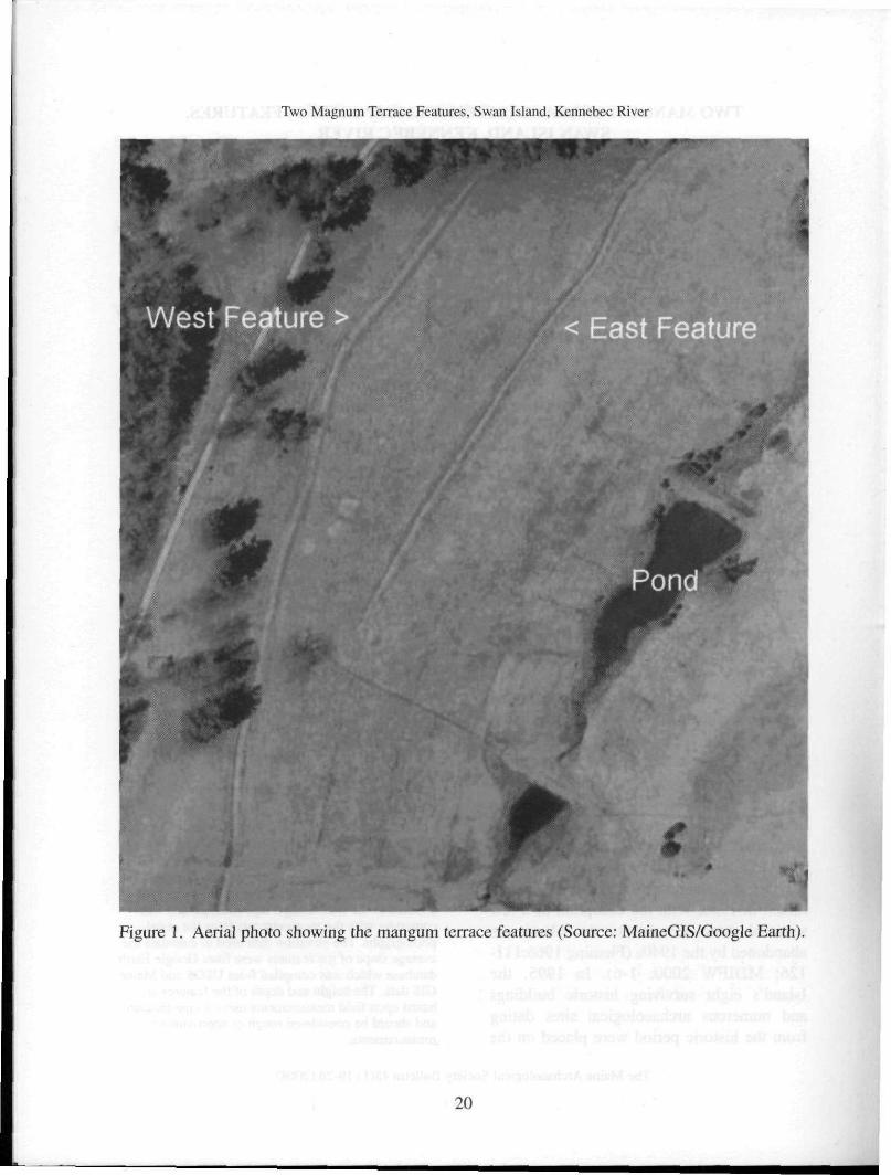
The site consists of two separate
d i tch-and-embankment features. The two
features are located in an approximately
35-acre open field.1 The field was plowed and
cultivated with wheat and corn crops until
1936 when the farm was abandoned.2 The
western edge of the field is delineated by a
north-south dirt road that runs the length of
the island. The north and south sides of the
field are delineated by the partial remains of
a broken-down stone wall and large-diameter
trees which are typically found along the
edge of farm fields. The east side of the field
is delineated by a series of three man-made
farm ponds that drain northward to the
Kennebec River. The farm ponds are located
in the lowest elevation of the field and water
from the field drains down slope (from west
to east) to the ponds. On the east side of the
farm ponds is another open field.
' 44o 03' 15.13" N 69 o 47'46.57" W 2 Information about the field from a recently installed interpretative sign at the site of the Wade House. 1 The length, width, and distance measurements were taken from aerial photographs using the Google Earth software. The width of the features was spot checked in the field using a tape measure and was consistent with the measurements from the aerial photographs. The elevation data used to calculate the average slope of the features were from Google Earth database which was compiled from USGS and Maine GIS data. The height and depth of the features are based upon field measurements using a tape measure and should be considered rough or approximate measurements.
The Maine Archaeological Society Bulletin 48(1): 19-26 (2008)
19
Two Magnum Terrace Features, Swan Island, Kennebec River
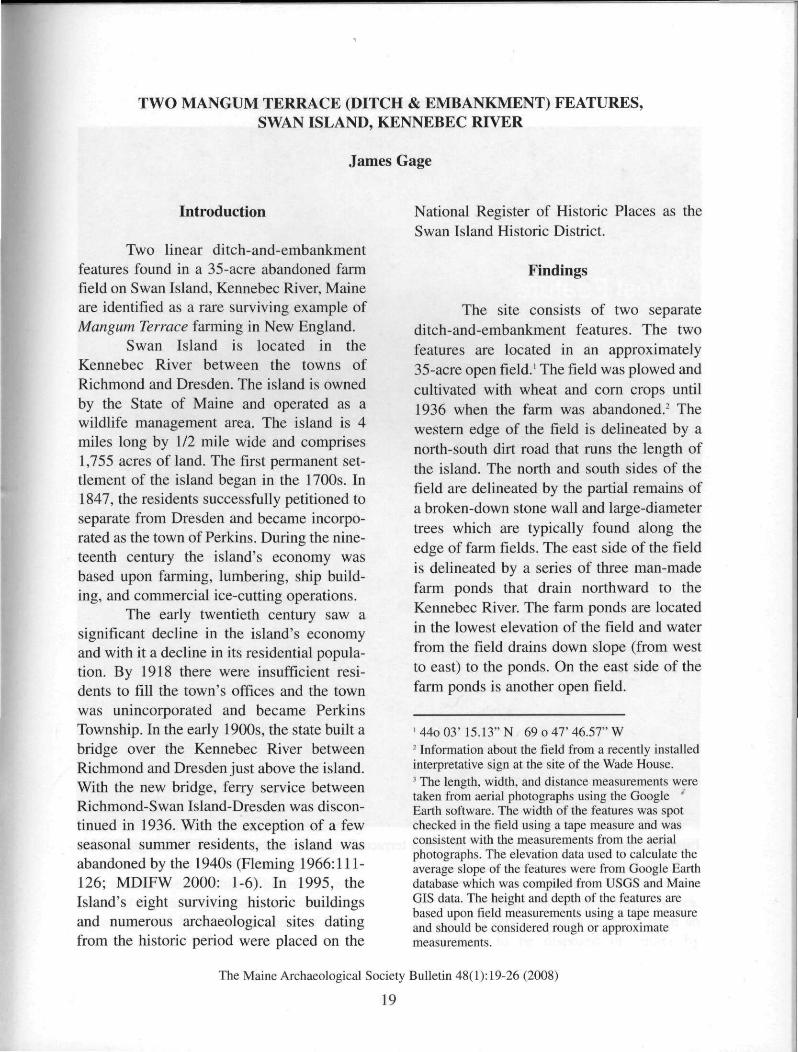
Figure 1. Aerial photo showing the mangum terrace features (Source: MaineGIS/Google Earth).
Two Magnum Terrace Features, Swan Island, Kennebec River
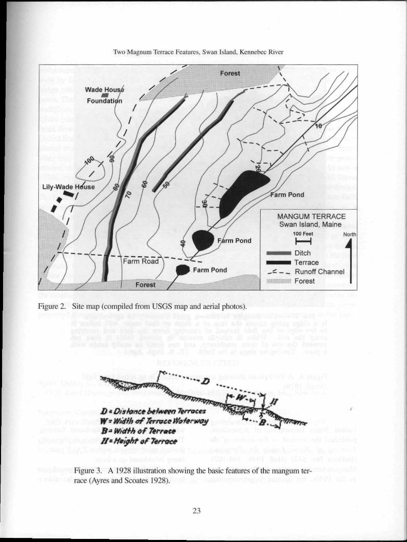
The west ditch-and-embankment fea
ture is approximately 1,600 ft in length.3 The
ditch is situated on the uphill side of the
embankment. The ditch varies from 12 to 16
ft in width and the depth varies from 12 to 24
in. The embankment averages 16 ft in width
and the height varies from 24 to 30 in. The
southernmost three-quarters of the feature
drains southward with an average 9-inch drop
in elevation per 100 ft. The north and south
ends of the ditch and embankment terminate
a few feet short of the edge of the field. Both
these ends curve slightly downhill.
The east ditch-and-embankment fea
ture is approximately 800 ft in length. The
ditch is situated on the uphill side of the
embankment. The ditch varies from 12 to
14 ft in width and the depth is generally less
than 16 in. The embankment varies from
14 to 16 ft in width and its height varies from
12 to 24 in. The feature slopes from south to
north at an average 12-inch drop in elevation
per 100 ft. The north side of the ditch-and-
embankment connects to a modern backhoe-
dug drainage ditch, which in turn connects to
the outflow from the farm ponds. The south
side of the feature fades out in the middle of
the field.
On the south end, the two features are
approximately 190 ft apart. In the middle
they are approximately 260 ft apart. At the
north side they are approximately 175 ft
apart. Both features follow the general con
tour of the hillside.
Rose bushes (Rosa multiflora) were
observed scattered throughout the field and
on the embankments. A line of intermittently
spaced bushes was discernible along the
length of the east side (down slope) of the
west embankment feature. The bushes were
less than 2 ft in height due to periodic mow
ing of the field by the Department of Inland
Fisheries and Wildlife.
Discussion
The two linear ditch-and-mounded
embankment features were first identified by
the author in 2004. The size, length, and
design of the two ditches and embankments
were unusual and not the typical type of
open-ditch drainage used on nineteenth and
early twentieth century New England farms.
Based upon these unusual characteristics, the
author reported the site to the Maine Historic
Preservation Commission (MHPC). A review
of the Maine Historic Sites Inventory deter
mined that the features had not been previ
ously identified or documented. In June 2007
the author conducted a site walk of the fea
tures with Leon Cranmer, historical archaeol
ogist, and Bill Burgress, both from Maine
Historic Preservation Commission.
The site walk concluded that the two
features were related to agricultural activities
on the property, specifically drainage of
excess water from the farm field. The subsoil
of the island is marine clay, called the
Presumpscot Format ion , which makes
absorption of water difficult and leads to
much standing water on the surface. The site
walk determined the purpose of the features
but was unable to explain the unusual design
of the drainage system.
There were two significant and
unusual design elements. First, both open
ditches were accompanied by a mounded
embankment created from the excavated soil
removed from the ditches. Nineteenth centu
ry open ditches found on farms and along
roads in New England generally lack a
mounded embankment. The excavated dirt
from the ditch was either hauled away or
spread out evenly adjacent to the open ditch.
An 1860 manual on farm drainage states,
"There is a large quantity of earth from an
open drain to be disposed of, either by
21
Two Magnum Terrace Features, Swan Island, Kennebec River
spreading or hauling away" (French 1860:
101-102). An 1884 farm manual recom
mends, "Then, with a scraper, carry the earth
out, spreading it equally on each side over
the outer surface." (Periam 1884: 333)
Second, most open ditches were along the
edges of the field (with the exception of salt-
marsh hay fields) not in the middle of the
field where they would potentially interfere
with plowing and would also reduce the
amount of acreage available for farming
(French 1860:102). An intensive search of
Cornell University's The Core Historical
Literature of Agriculture (CHLA) full text
database4 and Google 's full-text book data
base5 identified an agriculture farming tech
nique, the mangum terrace, which matches
these two unusual characteristics.6
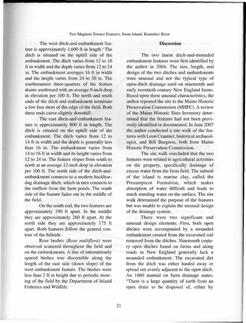
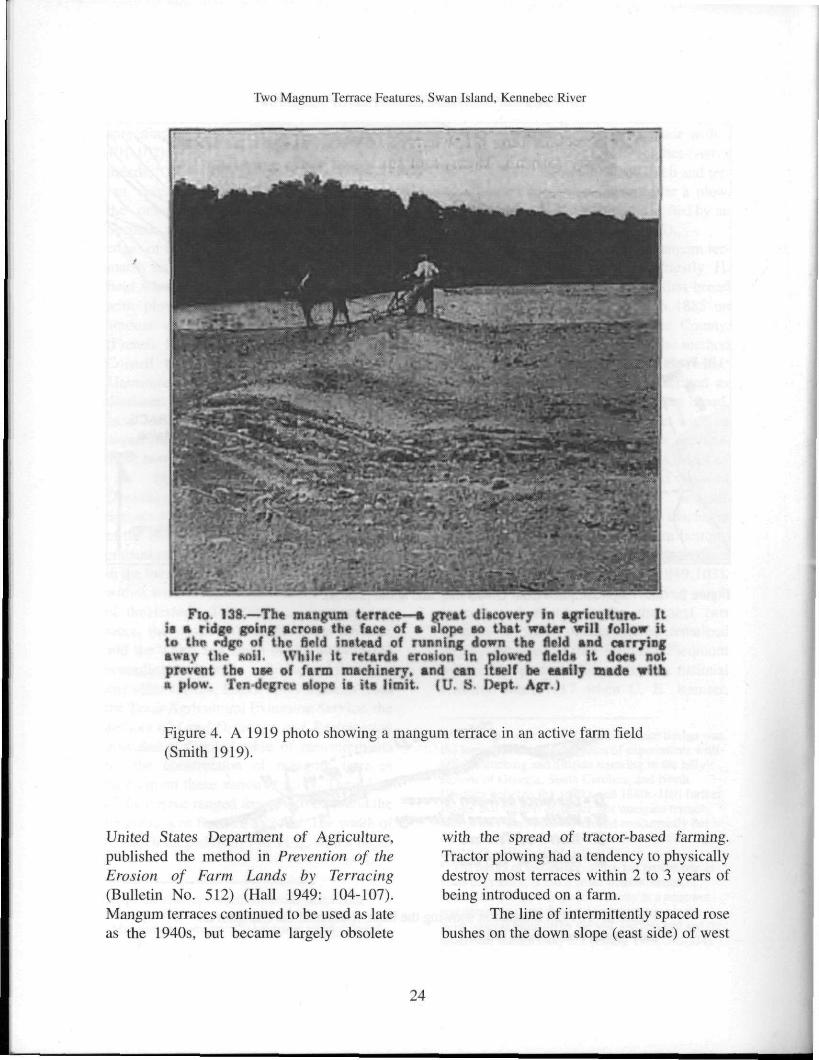
Figure 3 is reproduced from Land
Drainage and Reclamation (Ayres and
Scoates 1928) and illustrates the basic design
of the mangum terrace. It consists of a wide
embankment , which is generally referred to
in the literature as a terrace or broad terrace,
with a wide shallow ditch on the uphill side
of the terrace. The distances between ter
races, the width and height of the terraces,
and the width and depth of the ditch varied
according to the soil type, slope of the field,
and other factors. Based upon research from
the Texas Agricultural Extension Service, the
authors of Land Drainage and Reclamation
provided a detailed table of measurements
for the construction of mangum terraces
based upon these various factors. The width
of the terrace ranged from 16 to 22 ft and the
height ranged from 15 to 24 in. The width of
the ditch ranged from 7 to 11 ft, with a depth
1 http://chla.library.cornell.edu/c/chla/index.html 5 http://www.google.com/books 6 Mangum terraces are also known as graded broad terraces.
of 9 in. They recommended a grade with a
7-inch drop per 100 ft for the ditches (Ayres
& Scoates 1928:285-287). The ditch and ter
races were constructed using either a plow,
road scraper, or a V-shaped drag pulled by an
oxen or horse team (Hall 1949:105).
The development of the mangum ter
race is generally credited to Priestly H.
Mangum Sr.7 He constructed his first broad
ditch-and-embankment terraces in 1885 on
his farm near Wake Forest, Wake County,
North Carolina. The purpose of the method
was to reduce soil erosion on hillside fields.8
The terraces on his farm are described as
being, "about 2 feet high and 6 feet broad,
with a flat depression about 10 feet wide on
the up-slope side. The grade was approxi
mately 8 to 10 inches per 100 feet. Most of
the terraces were discharged into wooded
areas, but in one field a "canal," or wide
ditch, was constructed to carry the discharge
from the upper terraces to a stream bottom.
Crop rows were often run across the terraces
at an obl ique angle" (Hall 1949:103).
Mangum's terracing system received much
interest and attention over the next two
decades but much of that interest remained
largely confined to the southern Piedmont
region. The practice did not receive national
attention until 1917 when C. E. Ramser,
7 Arthur Hall argues the ditch and terrace design was the logical outcome from years of experiments with hillside ditching and hillside terracing in the hilly regions of Georgia, South Carolina, and North Carolina between the 1820's and 1880s. Hall further argues that there is evidence that mangum terrace design may have been developed concurrently but independently in several different locations during the 1880s. (Hall, 1949: 101-103) 8 "The theory of this terrace, which has proven true in years of practice, is that a broad shallow stream of water does not have as great a velocity as a narrower and deeper one, and that by decreasing the velocity more water is taken up by the soil, and less soil and fertilizers are washed away ..." (Elliott, 1919: 333-334).
22
Two Magnum Terrace Features, Swan Island, Kennebec River
Figure 2. Site map (compiled from USGS map and aerial photos).
r
JO • Of sr fane* aeinteen Terraces
W* Width of Terrace Waterway
B* Width of Terrace
ff* Height af Terrace
Figure 3. A 1928 illustration showing the basic features of the mangum ter
race (Ayres and Scoates 1928).
23
Two Magnum Terrace Features, Swan Island, Kennebec River
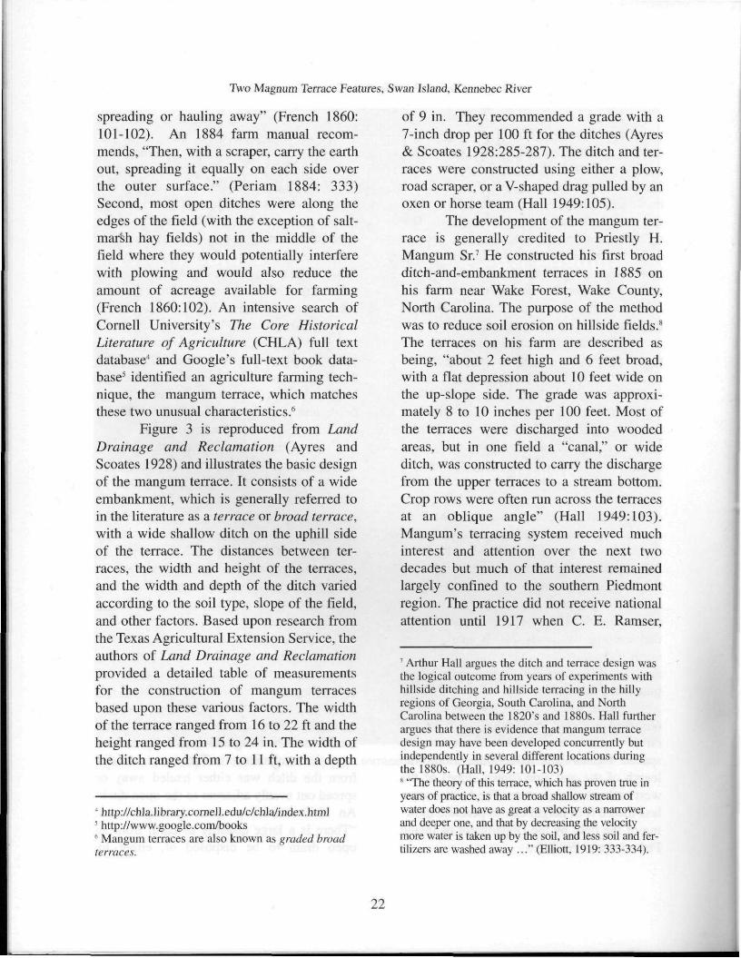
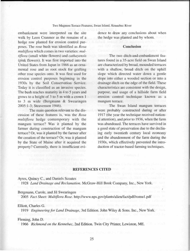
FIG 138.—The mangum terrace—a great discovery in agriculture. It is a ridge going across the face of a slope so that water will follow it to the rdge of the field instead of running down the field and carrying away the anil. While it retard* erowion In plowed field* it does not prevent the use of farm machinery, and can itself be easily made with n plow. Ten degree alope is its limit. (U. S Dept Agr.)
Figure 4. A 1919 photo showing a mangum terrace in an active farm field
(Smith 1919).
United States Department of Agriculture,
published the method in Prevention of the
Erosion of Farm Lands by Terracing
(Bulletin No. 512) (Hall 1949: 104-107).
Mangum terraces continued to be used as late
as the 1940s, but became largely obsolete
with the spread of tractor-based farming.
Tractor plowing had a tendency to physically
destroy most terraces within 2 to 3 years of
being introduced on a farm.
The line of intermittently spaced rose
bushes on the down slope (east side) of west
24
Two Magnum Terrace Features, Swan Island, Kennebec River
embankment were interpreted on the site
walk by Leon Cranmer as the remains of a
hedge row planted for erosion control pur
poses. The rose bush was identified as Rosa
multiflora which comes in two varieties: mul
tiflora (small white flowers) and cathayensis
(pink flowers). It was first imported into the
United States from Japan in 1866 as an orna
mental rose and as root stock for grafting
other rose species onto. It was first used for
erosion control purposes beginning in the
1930s by the Soil Conservation Service.
Today it is classified as an invasive species.
The bush reaches maturity in 4 to 5 years and
grows to a height of 3 to 5 m with a crown 1
to 3 m wide (Bergmann & Swearingen
2005:1-3; Steavenson 1946).
The main question relevant to the dis
cussion of these features is, was the Rosa
multiflora hedge contemporary with the
mangum terrace? Was it planted by the farmer during construction of the mangum
terrace? Or, was it planted by the farmer after
the creation of the terrace? Or, was it planted
by the State of Maine after it acquired the
property? Currently, there is insufficient evi
dence to draw any conclusions about when
the hedge was planted and by whom.
Conclusion
The two ditch-and-embankment fea
tures found in a 35-acre field on Swan Island
are characterized by broad, mounded terraces
with a shallow, broad ditch on the uphill
slope which directed water down a gentle
slope into either a wooded section or into a
drainage ditch on the edge of the field. These
characteristics are consistent with the design,
purpose, and usage of a hillside farm field
erosion control technique known as a
mangum terrace.
The Swan Island mangum terraces
were probably constructed during or after
1917 (the year the technique received nation
al attention), and prior to 1936, when the farm
was abandoned. The terraces have survived in
a good state of preservation due to the declin
ing early twentieth century local economy
and the abandonment of the farm during the
1930s, which effectively prevented the intro
duction of tractor-based farming techniques.
R E F E R E N C E S CITED
Ayres, Quincy C , and Daniels Scoates
1928 Land Drainage and Reclamation. McGraw-Hill Book Company, Inc., New York.
Bergmann, Carole, and Jil Swearingen
2005 Fact Sheet: Multiflora Rose, http://www.nps.gov/plants/alien/fact/pdf/romul.pdf
Elliott, Charles G.
1919 Engineering for Land Drainage, 3rd Edition. John Wiley & Sons. Inc., New York.
Fleming, John D.
1966 Richmond on the Kennebec, 2nd Edition. Twin City Printer, Lewiston, ME.
25
Two Magnum Terrace Features, Swan Island, Kennebec River
French, Henry F.
1860 Farm Drainage. C. M. Saxton, Barker & Co., New York.
Hall, Arthur R.
1949 Terracing in the Southern Piedmont. Agricultural History 23(2):96-109.
Maine Department of Inland Fisheries & Wildlife (MDIFVV)
2000 A History and Self-Guided Tour of Steve Powell Wildlife Management Area.
Periam, Jonathan
1884 The Home & Farm Manual. [Reprint] Greenwich House, New York.
Smith, J. Russell
1919 The World's Food Resources. Henry Holt and Company, New York.
Steavenson, Hugh A.
1946 Multiflora Rose for Farm Hedges. The Journal of Wildlife Management 10(3):227-234.
26