t>y - open...
TRANSCRIPT

Late Cenozoic stratigraphy and structure of a partof the Walnut Grove Basin, Yavapai County, Arizona
Item Type text; Thesis-Reproduction (electronic)
Authors Hook, Donald Lewis, 1932-
Publisher The University of Arizona.
Rights Copyright © is held by the author. Digital access to this materialis made possible by the University Libraries, University of Arizona.Further transmission, reproduction or presentation (such aspublic display or performance) of protected items is prohibitedexcept with permission of the author.
Download date 23/05/2018 03:54:37
Link to Item http://hdl.handle.net/10150/551256

LATE CENOZOIC THE WALNUT
STRATIGRAPHY AND STRUCTURE OF A PART OF GROVE BASIN, YAVAPAI COUNTY, ARIZONA
t>yDonald L. Hook
A Thesis
submitted to the faculty of theLi
Department of GeologyXvC-in partial fulfillment of the requirements for the degree of
MASTER OF SCIENCE .
in the Graduate College, University of Arizona
1956


/Tf 79/
This thesis has been submitted in partial fulfillment of require
ments for an advanced degree at the University of Arizona and is de
posited in the Library to be made available to borrowers under rules of the Library. Brief quotations from this thesis are allowable without special permission, provided that accurate acknowledgement of
source is made. Requests for permission for extended quotation from or reproduction of this manuscript in whole or in part may be granted
by the head of the major department or the dean of the Graduate
College when in their judgment the proposed use of the material is
in the interests of scholarship. In all other instances, however, permission must be obtained from the author.
Signed:

page
GEOLOGIC HISTORY................................... 31ECONOMIC GEOLOGY.... ............................... 35APPENDIX A...... ......... 36
Description of Measured Section........i........ 36APPENDIX B......... .../......................... k6
Spectrographic Analysis of Tuffs and Lavas..... 46REFERENCES C I T E D ........ $0
iv

LIST OF ILLUSTRATIONS
page
PLATE 1 Index Map Showing Location of AreaFollowing page........ 2
PLATES 2 - 1 0 Photographs Following page. ...... 4’9
PLATE 11 Geologic Map .................... in, pocket
PLATE 12 Structure Sections .................... inpocket
PLATE 13 Columnar Section ............... inpocket
v

ABSTRACT.
Lower Pliocene lacustrine sediments, herein named the Milk Creek formation, their fluviatile equivalents, and volcanics unconformably overlie pre-Cambrian Bradshaw granite in the Walnut Grove Basin.
Pleistocene lacustrine and flood-plain deposits unconformably over- lie the Milk Creek formation. Terrace gravels and dissected alluvial fans conformably overlie the Pleistocene flood-plain sediments.
Vertebrate fossils positively date the upper part of the Milk Creek formation as Clarendonian, but the lower part may be older.The lacustrine strata which unconformably overlie the Milk Creek
formation contain Pleistocene mammoth remains.
The Lower Pliocene sediments are tilted to the northeast and
three major faults displace them. Folding is almost completely lack
ing. A compound delta with prominent foreset beds is developed along the northern end of the Lower Pliocene lake site.
Volcanic activity was prevalent throughout Early Pliocene time.
At least two ages of lavas are recognized and prominent tuffs indicate
numerous intervals of explosive volcanism. One basalt flow is inter
calated with the Milk Creek formation. The source of the lavas was
apparently fissures within the area, but no information is available
regarding the location of the explosive vents.
vi

INTRODUCTION
Geologic Setting
Late Tertiary lacustrine arid flood-plain sedimentary rocks and volcanic rocks are deposited on pre-Cambrian basement in the Walnut Grove Basin. The area is shown on the present geologic map of Arizona
as undifferentiated Tertiary sediments and volcanics which rest on
Bradshaw granite. The rocks are gently dipping to the northeast and
display little faulting and almost no folding.
Method of Approach
Approximately seven weeks were spent in the field during July
and August of 1955* The area was mapped at a scale of one inch equals
1000 feet on a base map which was enlarged from the Kirkland and Mt.
Union quadrangle maps of the United States Geological Survey. Minor
revisions were later made on this map in the field. A spectrograph!c analysis of the tuffs was obtained in hope that trace elements might
be present which would aid in regional correlation. ; Structure sections accompany the geologic map.
Previous Work
Previous work in the area is lacking. Jaggar and Palache (1905)
included a portion of the area in their Bradshaw Mountains Folio, but
this was reconnaissance mapping which only distinguished Tertiary
rocks from basement rocks. Charles A. Reed (1950) published a short

2
report in Plateau in which he briefly discussed a new mammalian fossil
locality within the area and also suggested the name, "Milk Creek
beds", for the sediments. Later Dr. Donald L. Bryant of the Univer
sity of Arizona spent several weeks in the area measuring stratigraphic
sections and mapping in reconnaissance.
Acknowledgements
I wish to thank Dr. John F. Lance and Dr. Donald L. Bryant of
the University of Arizona for their suggestion and guidance of this thesis. Thanks are also due to Mr. Paul Howell of the Arizona State Bureau of Mines for the spectrograph!c analysis. Funds for the field work were made available through a grant to Dr. Lance from the National Academy of Science.
Location
Walnut Grove is a small community located on the Hassayampa
River about 25 miles due south of Prescott,. Arizona. It is approxi
mately 10 miles southeast of Kirkland Junction which is located on
U. S. Highway 89 about 12 road miles north of Yarnell and about 28 road miles south of Prescott. Walnut Grove is easily accessible via
a county dirt road which leads southeastward from Kirkland Junction to
Wagoner which is about eight miles south of Walnut Grove. The thesis
area is about four miles northeast of Walnut Grove (PI. l) and is
readily accessible via the ranch road leading to Shields' Ranch.
Following a heavy rain, this road is impassable for a conventional automobile.

PLATE 1
Prtscotf v -k
milts
y a v a p a i C o u n t y
Index map s'nowing location of area.

3
The Walnut Grove Basin is unnamed on the topographic map of
Arizona, but the name is applied by the members of the geology depart
ment of the University of Arizona to that sedimentary basin which includes the community of Walnut Grove. The basin covers approximately l4o square miles and includes the community of Wagoner. I therefore propose the name, Walnut Grove Basin, for this locality.
Physiographic Setting
The Walnut Grove Basin is situated in the Mountain region of the
Basin and Range physiographic province. This zone of mountains separates the Desert region of the same physiographic province from the
Colorado Plateau province (Ransome, 1903, 1919)• It is characterized by isolated mountain ranges separated by narrow basins or valleys,
but unlike the Desert region, the mountains are larger and constitute
a larger percentage of the topography. This zone also serves as a
transition zone between the Desert region and the Colorado Plateau in
that it displays structural and stratigraphic characteristics of both.\
Topographic Setting
The Walnut Grove Basin is a portion of the Hassayampa River
valley and trends in a general northwest direction. The basin is
bounded on only three sides by topographic highs. It is flanked on
the east and north by the northwest-trending Bradshaw Mountains. On
the southwest and west it is flanked by the foothills of the parallel
trending Weaver Mountains which form the steep escarpment of Yarnell
Hill. The extreme south end of the basin is approximately closed by

1+
the foothills of the Bradshaw Mountains where they converge with the
Weaver Mountain foothills. The northwest end of the basin is open
and Cenozoic sediments can be traced nearly continuously for many tens
of miles beyond Kirkland into the vicinity of Seligman. It may be that these sediments are actually an integral part of the same sedi
mentary basin; however, I arbitrarily place the northwest limits of the Walnut Grove Basin about two miles west of the Hassayampa River northwest of Walnut Grove.
That portion of the Walnut Grove Basin which includes the thesis
area is actually a northwest extension of the Cellar Basin as named by
Jaggar and Palache (1905). The thesis area occupies approximately 15 square miles and lies north and northeast of Black Mountain. Black
Mountain (PI. 2, fig. 1) is the most prominent topographic high within
the Walnut Grove Basin and it "approximately divides the basin into two
parts, both topographically and geologically.
Relief and Drainage
The average elevation of the thesis area is about 4100 feet with
an average relief of 50 to 75 feet. Black Mountain rises to an elevation
of 4972 feet and affords a maximum relief of about 850 feet. Badland
topography is characteristic of most of the area, especially where vege
tation is thin, and amphitheater-like depressions are numerous. The nearly flat-lying sediments are intensely dissected by steep-sided
arroyos which entrench themselves still deeper during periodic flash
floods. The drainage system of the region is of the intermittent
type, however; during rainy years the Hassayampa River flows as a per-

5
manent stream which disappears in the dry sediments of the Basin and
Range farther south. The Hassayampa River flows southward from the
Bradshaw Mountains about three miles west of the thesis area and pro
vides the major drainage of the Walnut Grove Basin. The tributaries of Slate Creek and Milk Creek flow generally southward through the
eastern part of the thesis area and join the Hassayampa a few miles to the south.
Climate and Vegetation
The climate of the basin is semi-arid. The average rainfall
since 1951# as reported by Court Carter of Walnut Grove, has been about 17 inches. The rainy season is during the months of June, July, and August when daily thunder showers are the rule. During these
months in 1955# 13.15 inches of rainfall were reported. Torrential
cloudbursts are not infrequent and 3-5 inches of rain were reported during a single 55 minute interval in August 1955• Within a few minutes squalls such as this create raging torrents of the normally
dry stream beds and are exceedingly effective in washing out roadbeds.
It is impossible to cross these streams at flood stage even with an
automobile. The waters, however, recede as rapidly as they rise and
generally within an hour or so it is again possible to ford. Even the
slightest shower makes the roads slippery and a shovel is a necessary
item during the summer months. The maximum temperatures during the
summer months are above 100° while the minimum winter temperatures are between 20° and 30°
Cedars and scrub oak constitute the bulk of the flora with pinon

6
and jack pine scattered at the higher elevations. Willow and cotton
wood grow along the stream bottoms while mesquite, juniper, hackberry,
manzanita, black walnut, yucca, century plant, prickley pear cactus,
and various grasses are abundant throughout the area.

7
STRATIGRAPHY General Relations
Late Cenozoic continental sediments and volcanics are exposed in
many of the intermontane basins of the Mountain region of the Basin
and Range physiographic province. The sedimentary basin which separates the Bradshaw Mountains from the Weaver Mountains is of this type. The
sediments are gently dipping (PI. 3) and are deposited in relatively
shallow depressions which are eroded from crystalline basement rocks.The Walnut Grove Basin, as defined, appears to be comprised of
at least two, small, interconnected sedimentary basins, with the sedi
mentation in each controlled by local topography and drainage. The
overall geologic history of the smaller "sub-basins".is similar if not
identical, yet each seems to be a distinctly separate geologic
feature. The Cellar Basin is one.
The Cellar Basin, of which the thesis area is a part, is closed
on the southwest and west by the finger-like projection of Black Mountain and on the east, northeast, and north by the foothills of the Bradshaw Mountains. This depression was formed by drainage which
flowed northwestward along the northeast side of Black Mountain. The
drainage may have continued in a northwest direction, or it may have
turned south around the west end of Black Mountain along the present
channel of the Hassayampa River.. Later the basin was completely closed
by regional tilting from the southwest which uplifted the northwestern
end. The depositional basin can be visualized by comparing the basement

8
, rock to one’s right hand. If one orients his right hand with the back
of the hand up, the fingers extended and joined, and the thumb ex
tended away from the hand, the hand and fingers represent the Bradshaw.
Mountains and the thumb represents Black Mountain. The Cellar Basin occupies the space between the hand and thumb, and the thesis area is
in the northwestern part.The Cenozoic sedimentary rocks of the Cellar Basin are deposited
on a pre-Cambrian basement complex of Yavapai group and Bradshaw granite. "These granites, diorites, gneisses, schists, and phyllites are the dominant rock types in the Bradshaw and Weaver Mountains.
The sediments are interbedded sandstones, siltstones, and tuffs of lacustrine origin which interfinger with conglomerate and fanglomerate
of flood-plain origin. They are of Lower Pliocene and Pleistocene
ages. The Lower Pliocene sediments contain one interbeeded basalt
flow and rest on a dacite flow which overlies Bradshaw granite. Where
Pleistocene rocks are identified, they rest unconformably on the more steeply tilted Lower Pliocene sediments.
The name, "Milk Creek beds", was informally proposed by Reed
(1950) for the fossiliferous Lower Pliocene sediments in the thesis
area which contain vertebrate remains. The name. Milk Creek formation,
is here proposed for the Lower Pliocene and possibly older sediments in
the Cellar Basin. The name is derived from their proximity to Milk
Creek which flows south through the thesis area. The type section was
measured and described in sections 5, 6, 7, 8, 16, and 17, T. 11 N.,R. 2 W., Gila and Salt River base and meridian. A columnar section
accompanies this report and the traverses where the section was measured

9
are indicated on the geologic map.
Sedimentary Rocks
Cenozoic Sediments
Milk Creek formation-The Milk Creek formation consists of about 2300 feet of lake
sediments. The rocks are predominantly siltstone and fine-grained sandstone with interbedded^layers of medium- and coarse-grained sand
stone and tuff. The basal part is conglomerate and conglomeratic sand
stone. The overall lithology is markedly homogeneous; however, the
formation can be divided into three members. This subdivision is based partly on lithology and partly on structure. The formation
consists of a lower member, a middle member, and an upper member.
Lower Member- The Lower member of the Milk Creek formation is
exposed along the northeast flank of Black Mountain in sections 17
and l8. It consists of feet of conglomeratic sandstone with inter- bedded layers of conglomerate, silty sandstone, and tuff. The unit
weathers to a light tan to light gray-green color with local zones of
yellow brown and red. The sediments presumably rest on a dacite flow
which overlies the granite of Black Mountain, and where the dacite is
eroded, they rest on Bradshaw granite. The basal section is coarser
grained than the upper part with the exception of an 11 foot thick conglomerate bed about 75 feet from the top. The upper 50 feet of
the member consists of thin-bedded mudstone and siltstone, and the
upper three to four feet contain clay. Where it is in contact with an
10
overlying basalt flow, this argillaceous zone is baked to a brick-red
color.The pebbles and cobbles in the conglomerate are composed of
granite, gneiss, schist, and phyllite and were undoubtedly derived
from the Bradshaw granite and the Yavapai group which make up the basement. Most of the larger clastic materials are sub-angular to sub-rounded, indicating-that they were not transported any great dis
tance before deposition. The basal sediments in the Lower member are more representative of a flood-plain environment of deposition than
of a lacustrine environment.
Middle Member- The Middle member is best exposed east and southeast of Shields' Ranch in section 17. It is 1062 feet thick and con
sists of massive argillaceous siltstones and argillaceous sandstones
with beds of green clay and thin, interbedded layers of hard, coarse,
resistant sandstone and tuff (pi. 3, fig. 2). The rocks are predominantly light tan to light gray green with prominent snow white beds of
tuff. The uppermost tuff has a distinctive light yellow-green color
where it is exposed southeast of Shields' Ranch. It grades into white tuff a short distance to the north. <
The rocks are characteristically friable with the exception of the
hard sandstone layers and the resistant tuff beds. This unit weathers
to a badland topography (PI. 4, fig. l) typified by amphitheater-like
depressions (PI. 10, fig. l) in the gently dipping sediments. Pedistal
rocks are common with a layer of thin, hard, resistant sandstone capping
the softer, more massive argillaceous siltstones and sandstones.
Layers of volcanic bombs(PI. 4, fig. 2) are found in several

11
horizons in the middle part of the member, particularly southeast of
Shields' Ranch. Locally these layers are 18 inches to two feet in
thickness and contain "bombs from pea size up to 10 inches across.The majority of the bombs are. £ inch to two inches in diameter and
are well-rounded and nearly spherical in shape. They are highly vesicular with a relatively low specific gravity. They are inter-
bedded with very coarse-grained sand and granules and were probably deposited during the rainy season when larger volumes of water were moving into the lake basin. Some of these bombs are somewhat spindle-
shaped and may have been airborne to the site of deposition. Others are large and dense and one would expect them to be interbedded with other coarse clastic materials of comparable weight if they had been
transported by water, but none were found with the bombs.
Contact relationships between the Middle member and the older
rocks differ from place to place. South of Shields' Ranch the member
rests on the Lower member. Northwest of Shields' Ranch it rests on the basalt flow which overlies the Lower member, and still farther
west, in section 12, it rests on dacite.Locally the basal part of the Middle member consists of about 25
feet of conglomerate and conglomeratic sandstone. This zone is charac
teristically light tan to light purplish-pink and contains cobbles of
dacite and basalt up to six inches in diameter. The color of the matrix
comes primarily from the dacite which weathers to a purplish-pink
color. The cobbles are obviously derived from both the underlying
basalt and dacite and the unit could be considered an "intraformational
conglomerate.

12
Upper Member- The Upper member of the Milk Creek formation is
exposed throughout most of the northern and eastern parts of the
thesis area. The unit is best exposed in sections 5 and 6 where it
is 7U7 feet thick and strongly cross-heeded (PI. 5j PI. 6). In the eastern part of the area it is 647 feet thick, displays no cross- bedding, and is not unlike the underlying Middle member except for the distinct decrease of interbedded thin layers of hard, resistant
sandstone.The Upper member is typically light tan to light gray in color,
but locally the beds are light greenish gray. The rocks are fine- to medium-grained sandstone with interbedded layers of siltstone, sandy and argillaceous siltstone, coarse-grained, resistant sandstone, and conglomerate. The average thickness of the bedding is about 10 feet;
however, numerous zones display bedding thicknesses of only a fraction
of an inch. The member appears strikingly homogeneous until examined
in detail (PI. 6, fig. l). It weathers to a badland topography
locally; however, this feature is not so pronounced as in the Middle
member. Amphitheater-like depressions are also developed, many of them with steep-sided, badland cliffs.
South of Pole Camp Canyon the cross-bedding is well developed in
an east-west zone immediately below the conglomerate and fanglomerate
(PI..7) which interfingers with the lacustrine rocks. This zone represents the approximate northern limit of the lake basin at the time of
cross-bed deposition. The cross-bedding is deltaic. Broad, flat, fore
set beds are prominent and locally they interfinger with each other.
Flat-lying, bottomset-type beds of fine- and medium-grained sandstone
13
and siltstone separate foreset layers and are distinctly subaqueous
in origin as they contain coarse-grained sandstone and conglomeratic
lenses (PI. 8). Distinct graded bedding (PI. 9) was observed in the foresets and the particles are as large as three to four millimeters In
diameter, which strongly indicate subaqueous origin. The interbedded greenish sediments indicate an environment which is more reducing than oxidizing. Locally the sandstone shows fair to poor sorting and has a
considerable clay content.This zone of cross-bedding represents not a single delta, but a
number of small deltas which coalesced to form an apron-like, compound
deltaic structure along the northern periphery of the lake basin. The streams which transported the sediment flowed generally south, and a
small delta probably formed at the mouth of each where it emptied into
the lake. Where two small deltas coalesced, foresets interfingered
with foresets producing overlapping along the line of juncture. Most
of the cross-bedding, however, is.tabular (Lahee, 1952, p. 90-91)-The sand which comprises the delta was subjected to considerable
wind action prior to final subaqueous deposition. Many of the particles
are well-rounded and locally the sediments are well-sorted and relatively "clean". The source of these wind-blown sands was probably a
relatively flat flood plain within the basin, but to the north of the lake.
A silvery-blue, cliff-forming tuff 10 feet thick is exposed in the
cliffs' immediately east of the P Bar Ranch in the northeastern part of
the area. The unit consists of 100 percent glass fragments and could
be classified as pumicite. It is markedly friable, yet highly resistant,

14
The tuff is east of the deltaic environment and for this reason the
glass fragments were preserved and lithified into tuff. As the glass
fragments fell into the deltaic environment, they were distributed
throughout the sediments by the more agitated waters. The fragments were undoubtedly: lithified into tuff in the lake south of the delta but this area has been subsequently eroded and the tuff is no longer
present.The Milk Creek formation represents the lacustrine facies of
coarse conglomeratic and fanglomeratic equivalents which surround the
Walnut Grove Basin. Coarse sediments transported basinward from the surrounding highlands were deposited around the periphery of the basin
where stream velocities suddenly decreased due to a reduction in stream
gradient. The finer sands and silts were carried farther into the.basin
where they were deposited in the lake. The interfingering relationship
between the conglomerate and the finer lake sediments is well exposed at the mouth of Box Canyon in the northeastern part of the thesis area.
Also the conglomerate becomes distincly coarser and more angular as it
is traced away from the basin toward the source area.
The Milk Creek formation was deposited in a lake which was not
unlike the present playa lakes of the Southwest; however, the lake
must have had some circulation since no salt or gypsum deposits are
present. It is possible that the conglomerate is, in part, representa
tive of a flood-plain environment which may have surrounded the lake.
The maximum water depth in the lake was probably 10 or 15 feet and was
in the deltaic environment, but the water depth was considerably less
and forms a striking horizon in the upper part of the Upper member.

15
over the rest of the lake. . The lake was deepest during the deposition
of the Upper member as indicated by the 10 to 15 foot vertical thick
ness of the foresets (Lahee, 1952, p. 88-90). Delicate cross-bedding and questionable ripple marks in the Middle member suggest that the
water was only, a few inches deep during most of this deposition. The lake basin apparently had its greatest expansion at or near the beginning of Early Pliocene time because the northern extremities of the older tuffs are farther north than those of the younger tuffs. As the lake diminished, the flood plain conglomerates transgressed the finer
lake sediments and truncated the tuff beds in Pole Camp Canyon in the northern part of the thesis area. A similar relationship is seen at Box Canyon and south of the P Bar Ranch. In the north central part of
the area south of Pole Camp Canyon, the conglomerate transgressed and
truncated the foreset beds and formed the topset beds of the delta.
Lower Pliocene vertebrate fossil remains are found in the Upper
member of the Milk Creek formation. Several fossil horizons are lo
cated beneath the lower foresets of the delta and a few scattered
remains are found in the foresets themselves. Apparently swampy con
ditions at the base of the delta front afforded bogs in which the
animals became entrapped and perished. The fossils are scattered and
no complete remains have been found in a single quarry. The bones
were either scattered by scavengers or by water as the sands were reworked at the delta front.
According to John F. Lance, the Milk Creek fauna is closely related
to the faunas of the Ricardo and Avawatz formations in California and
to the fauna of some parts of the Santa Fe beds of the Rio Grande valley

16
in New Mexico. The following faunal list was furnished by Dr. Lance.
Pliohippus - horse - 2 species
Pliauchenia sp. - camel
Procamelus coartatus - camel Merycodus sp. - antilocaprid
Osteoborus sp. - dog Aelurodon sp. - dog Vulpes sp. - foxBassariscus sp. - "ring-tailed cat"Pseudaelurus intrepidus - catsabre toothed catrabbit
rodents
Since the known Lower Pliocene sediments are in the upper 300 to
400 feet of the Milk Creek formation, nearly 2000 feet of sediments under-
ly the fossil zones. Although no fossils .have been found, these sediments are assumed to be Lower Pliocene in age because of the continuous
nature of the sedimentation. It is very possible that no break in
sedimentation occurred between Miocene and Pliocene times and that these
sediments are partly Miocene in age. The thickness of the rocks below
the known Lower Pliocene rocks compared to the total stratigraphic
thickness of the Milk Creek formation makes this postulation seem somewhat valid.
Conglomerate and fanglomerate-
Conglomerate which interfingers with the lake sediments is well

IT
exposed along the entire eastern and northeastern border of the thesis
area and in the north central part of the area south of Pole Camp
Canyon. The conglomerate section was not measured. No complete sec
tion is exposed and the conglomerate is a facies of the finer lake
sediments with a probable similar thickness. Where the conglomerate
is exposed its thicknesses differ from locality to locality and it pinches out basinward. It is possible that most, if not all, of the
sedimentary lake basin was covered by conglomerate which was subsequently removed by recent erosion.
The conglomerate forms a prominent cliff (PI. 3* fig* l) around the area and weathers to rounded ledges. The basal part consists of sub-angular to sub-rounded pebbles and cobbles and boulders of granite,
diorite, gneiss, schist, and phyllite inch to two feet in diameter.
The average size is one to two inches. The elastics become coarser and
more angular upward and toward the source area, and the unit grades
into a typical fanglomerate. No attempt was made to differentiate
these two rock types. Since no lake exists in the basin, the Recent
coarse clastic sedimentation has been that of an alluvial fan which
transgressed basinward, obscuring the older rocks around the basin peri
phery. The fan is presently being dissected. Southeast of the thesis
area along the western foothills of the Bradshaw Mountains, dissected
alluvial fans can be seen which display a more typical fan-shaped structure.
Pleistocene rocks-
Pleistocene sediments are positively identified in the NEjjNW^
sec. 12, T. 11 N., R. 3 W. These sediments are only 10 feet thick and

18
are whitish-gray to very light greenish gray in color. They consist
of argillaceous siltstone and clay which is extremely friable and re
sembles marl locally. The outcrops weather to a powdery exposure.
The sediments crop out in an area about 300 yards square and become
thinner towards the edges of the outcrop. They unconformably overlie Lower Pliocene rocks and are conformably overlain by Quaternary
terrace gravels and Recent soils which obscure the limits of the unit.The Pleistocene sediments may be representative of a small lake
or pond, or they may be only an eastern remnant of a much larger lake
basin. Plafker (oral communication) believes that a lake occupied the northwestern part of the Cellar Basin during Pleistocene time. He found cross-bedding in rocks of a younger age than the Milk Creek formation and also found unconformable relationships between rocks of
possible Pleistocene age and the Lower Pliocene rocks.
Pleistocene fossil remains include portions of teeth of a solitary
mammoth belonging to the genus Mammuthus. Small fresh-water pelecypods
and gastropods have been found along with plant remains and small pieces
of charcoal in the mammoth locality, but no additional information is available on them.
East of Shields1 Ranch, in section 17, flat-lying coarse clastic rocks unconformably overlie the Middle member of the Milk Creek formation
(PI. 10). These sediments are deposited on an irregularly channeled
erosion surface and are conformably overlain by Quaternary terrace gravels. The terrace gravels are less lithified than the underlying
rocks and this is the only means of distinguishing them. The coarse
sediments overlying the erosion surface are of flood-plain origin and

19
undoubtedly covered most of the eastern part of the basin prior to
Recent dissection and erosion. The rocks have the same stratigraphic
relationship to the Milk Creek formation as the known Pleistocene
sediments and are interpreted as Pleistocene. Plafker (1956) finds
similar relationships west and southwest of the area along the Hassayampa River. It is possible that the overlying rocks could be Middle or Upper Pliocene, but a Pleistocene age seems more probable.
Terrace gravels-
Undifferentiated Quaternary terrace gravels and Recent soils cover a great part of the thesis area. The north central part of the area immediately flanking Black Mountain is almost completely obscured by these sediments which make geologic correlation difficult (PI. 2).
The average thickness of the gravels and soils is three to four feet;
however, in the flatland north of Black Mountain, they are as thick
as 10 to 12 feet locally. Where the unit caps the crests of ridges,
it consists almost wholly of terrace gravels. In the flatland soils predominate.
The gravels are coarse and consist of angular to sub-angular fragments of basement rock. They are typically light tan to yellow-
tan in color from limonite staining. Where the unit displays the
characteristic color, the sediments are in place, and the basal contact
is located where the color changes. In the intensely dissected areas,
the coarse fragments are washed down the sides of gullies, and this float makes the unit appear thicker than it is.
The gravels are representative of a flood-plain or fanglomeratic
environment and the angular fragments indicate that deposition was

20
rapid. The gravels covered a broad, flat surface over the lake
sediments prior to Recent erosion. The projected surfaces of the
gravels are continuous and form a relatively smooth surface which
dips gently toward the center of the lake basin.
The terrace gravels may be Pleistocene in part since they are conformable with the known Pleistocene sediments. The surface on which the terrace gravels were deposited was probably that of the
Pleistocene flood plain which truncated the Lower Pliocene sediments.No attempt was made to distinguish between the conglomerate and
fanglomerate (page 16) and the terrace gravels except where the degree of lithification was obvious. In all localities the gravels grade laterally into the fanglomerate.
Alluvium-
Recent alluvium is developed in all of the major stream beds. The
soft,sediments are still being deposited and consist of silt, sand, and
gravel of unknown thickness.
Igneous Rocks
Pre-Cambrian Rocks
> . ’ _Bradshaw granite-
Bradshaw granite is the basement rock in the Cellar Basin. In
the thesis area the rock crops out only at Black Mountain, but it actu
ally surrounds the area except on the northwest. At Black Mountain the
granite is capped by a dacite lava, but locally where the dacite is not
present it is directly overlain by the Lower member of the Milk Creek
formation, and elsewhere overlain by basalt where both the dacite and

21
the Milk Creek formation are missing. Jaggar and Palache (1905, p. 3) give a detailed megascopic and microscopic description of the Bradshaw
granite. 'The granite is a resistant rock which typically weathers to
rounded boulders, some of which are 10 to 15 feet in diameter. It is
light tan to light pinkish-tan in color, is medium- to coarse-grained, and contains considerable biotite. Where observed the granite was mass
ive with no obvious linear or planar structures.
Tertiary Rocks
Dacite-A dacite lava caps the granite of Black Mountain in most locali
ties. Locally the extrusive is missing and is either eroded away or
was never deposited. Normally the dacite is overlain by the Lower
member of the Milk Creek formation, but locally where the Lower member
is missing, it is overlain by basalt or by the Middle member of the Milk Creek formation.
The dacite weathers to an irregular, blocky surface with a
purplish-pink color, locally it is black and appears almost glassy on the fresh surface. It is porphyritic with phenocrysts of quartz
and plagioclase feldspar, and displays flow structure, particularly
near the base. The unit is susceptible to chemical weathering and it
develops a powdery, pinkish soil which is difficult to distinguish from the overlying sediments.
Although the dacite is the second oldest rock unit in the thesis
area, it is probably Tertiary in age. It may be Lower Pliocene, but

22
is possibly older. The latest erosion which formed the Walnut Grove
Basin is apparently associated with the Miocene (?) and Pliocene up
lift of the Colorado Plateau (Longwell, 19^6; McKee, 1951), and the
dacite is post-erosion.
Basalt-A dark gray to greenish-black, augite basalt is intercalated with
the Milk Creek formation. The basalt contains phenocrysts of augite
and is locally vesicular. It weather medium gray to blue gray, is
locally jointed, and displays flow structure near the base. The basalt conformably overlies the Lower member of the Milk Creek formation and is overlain by the Middle member, and is best exposed along the north and northeast flank of Black Mountain.
The basalt is extrusive and has baked the upper three to four feet
of the underlying sedimentary unit to a brick-red color. It has a
maximum thickness of 3^2 feet immediately west of Shields' Ranch and
pinches out within a distance of a quarter mile to the southeast. The
unit also pinches out a few miles to the northwest. Apparently the surface on which the lava was extruded was highly irregular or else
considerable erosion took place prior to the deposition of the Middle member of the Milk Creek formation.
23
STRUCTURE
General Relations
The Mountain region is locally characterized by tilted, fault
block mountains which contain little or no folded strata. The subprovince was uplifted and tilted during Miocene (?) and Pliocene times
(Longwell, 1946; McKee, 1951) and for this reason the regional struc
tures and relationships are more nearly related to those of the Colorado Plateau than to those of the Desert region of the Basin and Range. Most
of the strata display a regional tilt and the majority of the structural features are genetically related to this uplift and tilting.
Many of the intermentane basins of the Mountain region are of
structural origin similar to those of the Desert region of the Basin
and Range. These basins are graben-like structures bounded by isolated
mountain ranges which are normal faulted into their present position.
The Walnut Grove Basin, like many others, is not a structural feature,
but is indirectly a result of the regional structure. The regional
uplift and tilting provided an initial gradient which helped to initiate
erosion. Possibly the erosion which carved the Walnut Grove Basin was
controlled by faults in the basement rock.
Regionally, the faults in the Mountain region trend generally north and the majority of them have their west side downthrown (see
Arizona State Geologic Map). Faults in the Walnut Grove Basin also
conform to this regional pattern. Two fault trends are developed in
the thesis area, one northeast and the other northwest.
\
24
The Walnut Grove Basin and the thesis area are little deformed.
Folds are essentially unknown and faults are few. Three major faults
are in the thesis area, one trending northeast and the other two
trending generally northwest. All other faults in the area are
parallel to these trends except for the east-west-trending fault in
Pole Camp Canyon. A series of gentle northwest-trending warps or
swells is vaguely apparent in.the northeast part of the area east of Milk Creek. These warps plunge gently to the southeast about 5° to 10°. Minor drag folds are developed along the Pole Camp Fault, and
these are parallel to the broader warps.The most obvious structural feature in the Walnut Grove Basin is
a gently northeast-dipping homocline. The degree of tilting is greater
in the older sediments along the northeast flank of Black Mountain and
decreases in the younger sediments. Part of this phenomenon is un
doubtedly due to initial dip of the strata as they were deposited on
the inclined flank of Black Mountain. Regional tilting from the
southwest accounts for the rest of the persistent dips. Because the
depositional basin was closed, the peripheral sediments must have
dipped toward the center of the basin from all directions, but this cannot be proved since the strata are obscured by younger rocks.
Regional tilting began during or before the beginning of Lower
Pliocene time. The regional dip of the younger sediments is less
than that of the older sediments, indicating that tilting occurred
contemporaneous with Lower Pliocene deposition. The tilting possibly
began during the Miocene as the Colorado Plateau was uplifted, and
ceased before the Pleistocene since the Pleistocene strata are essen-

25
Plafker (1956) mapped Lower Pliocene sediments along the west end of Black Mountain which dip into the mountain about 10°. This
supports a regional tilting of about 15° to 20° if an initial dip of 5° to 10° is assumed.
Structural features in the Walnut Grove Basin are related to the regional tilting. The dynamic forces from the southwest which produced
tilting also created the warps. The axes of these flexures are parallel
to the force front and were formed in the later stages of tilting. The
Colorado Plateau apparently served as a stable fulcrum about which the
rotary motion of the tilting acted. Probably compressional forces strong enough to produce warping did not build up until the latter
part of Early Pliocene time and thus the folding is very gentle.
The faults developed as regional compressive forces waned. Since
all of the faults are normal, they were produced not by compressive
forces, but by tensional forces. The release of force to the south
west, following regional tilting, established tensional vectors in
that direction which created north-trending normal faults with their
west sides downthrown. The northeast-trending fault is more difficult
to explain by these same forces, and it is possible that it is a more
recent expression of an older fault in the basement rock. The small
faults, many of which were not mapped because of their small magnitude, are indicative of slumping in the unconsolidated sediments. Displace
ments along these faults is of the order of two to five feet which is
too small to show at the map scale. Some of the displacements along
the major faults might also be a result of slumpage.
tially flat-lying and unconformably overlie the Lower Pliocene rocks.

26
Faulting
Pole Camp Fault-
The Pole Camp Fault is the most prominent fault in the thesis
area. It is located in the north-central part of the area and
trends generally northwest. Its southern end dies out about a quarter of a mile northwest of Battleship Butte and its northern end con
tinues in a northwest direction for an unknown distance beyond the
mapped area. The fault parallels the southwest side of Pole Camp
Canyon in the northern part of the area. Here differential erosion has formed a nearly vertical, northeast-facing fault-line scarp where fine, non-resistant, lacustrine sediments have been faulted against resistant conglomerates and fanglomerates higher in the
section.
The Pole Camp Fault is a normal fault with its west side down-
thrown. Along its entire mapped length the fault has displaced
lacustrine sediments against the coarser flood-plain conglomerates
and fanglomerates. Erosion has cut through the overlying conglomer
ates and fanglomerates on the upthrown side of the fault and has
exposed the underlying ^ilk Creek formation in a keyhole-shaped outcrop. The Pole Camp Fault is a high angle fault, but dips range from 90° to 30°.
At the southern end of Pole Camp Canyon, the Pole Camp Fault is
displaced by a smaller east -west-trending fault. Two small faults on
the east side of the Pole Camp Fault between the P Bar Ranch and Pole
Camp Canyon are parallel to and associated with the main fault.

27
The maximum displacement on the Pole Camp Fault is 600 to J00 feet (PI. 12, sec. A-A' ). This displacement diminshes to zero about
one mile south of the P Bar Ranch. Apparently the fault dies out a
few miles to the northwest because north of the mapped area, conglomer
ate and fanglomerate surround Pole Camp Canyon. The fault is definitely
younger than the conglomerate and fanglomerate which are believed to be
Pleistocene in part.
Basalt Ridge Fault-
The Basalt Ridge Fault is located along the northeast flank of Black Mountain west of Shields' Ranch and trends in a general northwest direction. The fault apparently dies out in the vicinity of Milk
Creek south of Shields' Ranch. Its northern end either dies out in the
covered flatlands north of Black Mountain or connects with the north
east-trending fault in the central part of the area. Since the dis
placement seems to increase in a northwest direction, the fault
probably continues for a considerable distance. The fault is covered by Recent soils and terrace gravels along most of its length and its
trace must therefore be inferred below the concealing sediments.
South of Shields' Ranch the Basalt Ridge Fault is locally exposed for
short distances; however, its trace becomes confused with other small
parallel-trending faults in this locality. These smaller faults are
probably branches of the main fault. The Basalt Ridge Fault is named
for the low basalt ridge along its northeast side which it has displaced upward.
The Basalt Ridge Fault is a normal fault with its west side down-
thrown. It has a maximum vertical displacement of about 500 to 600

28
feet (PI. 12, sec. A-A*) and has an apparent lateral displacement of
about 1500 feet (see geologic map, PI. 11). It is a moderately high
angle fault with one exposed dip of 50°.The fault was probably formed at the same time as the Pole Camp
Fault and is therefore considered to be Pleistocene. The Basalt Ridge Fault does not displace rocks younger than upper Lower Pliocene, and therefore it may actually be older than Pleistocene. .
Northeast-trending fault-A northeast-trending fault is located in the west-central part of
the thesis area. It is a normal fault with its west side downthrown. Most of the fault trace is covered by the soils in the flatland north
of Black Mountain, but it is well exposed in the conglomerate south of
Pole Camp Canyon where a dip of 73° was recorded. The northern end of
the fault dies out in the conglomerate and its southern end apparently
dies out in the granite of Black Mountain. Where the fault intersects
Black Mountain, it is very indistinct, and stratigraphic relationships
are difficult to determine. Some semblance of offset in the dacite is
apparent, but the displacement must be considerable if the correltation of sedimentary rocks in that locality is correct.
The maximum vertical displacement on the fault is about 300 feet and the apparent lateral displacement of the sedimentary rocks offset
by the fault is about 800 or 900 feet. The latest movement on the fault
is Pleistocene or younger since the fault offsets rocks of assumed Pleistocene age.
This northeast-trending fault is difficult to explain in terms of
the regional forces that produced the northwest-trending faults. It

29
could be an old fault which did not require forces of as great a mag
nitude to cause renewed movement along it as were necessary to form
the northwest-trending fault.
Folding
Warps-
A series of gentle flexures is vaguely apparent in the Milk Creek formation in the northeastern part of the thesis area. Local attitudes in the Milk Creek formation indicate these gentle warps. The warps are visually apparent when observed from the high conglomerate hills south
of Pole Camp Canyon. From this vantage point, the contact between the Milk Creek formation and the overlying conglomerate in the cliffs along the eastern border of the mapped area appears slightly warped. Because
of the steepness of the cliffs and the gradational contact of the Milk
Greek formation with the conglomerate, no attitudes were recorded at the contact.
The axes of the warps trend in a northwest direction and are perpendicular to the forces of regional tilting. They plunge gently to the
southeast and the plunge decreases in successive warps as one progresses
southward. Between the P Bar Ranch and Box Canyon the flexures plunge
about 5° to 10°. In the vicinity of Battleship Butte they flatten out to a maximum plunge of about 3°*
Drag folds-
Small drag folds are developed along the Pole Camp Fault in lion
Canyon and west of Box Canyon. Their axes are approximately parallel
to the fault trace and generally parallel to the warp axes. It is

30
probably coincidence that the drag fold axes are nearly parallel to
those of the warps, because the drag folds are directly associated
with the fault and not to the forces of regional tilting. It is
possible, however, that the drag folds are amplifications of previously
formed warps, and are indirectly related to the regional tilting.

31
GEOLOGIC HISTORY
In the Bradshaw Mountains region pre-Cambrian sedimentary and
volcanic rocks were metamorphosed to gneisses, schists, and phyllites
to form the Yavapai group. The intrusion of the Bradshaw granite stock took place at this time. Subsequent igneous activity emplaced
acid and basic dikes and small quartz-diorite stocks in the complex pre-Cambrian rocks. Periods of uplift and erosion followed which
eventually resulted in beveling of the pre-Cambrian surface (Jaggar
and Palache, 1905* p. 9)»Lower Pliocene continental sedimentary and volcanic rocks were
deposited on the pre-Cambrian basement in the Walnut Grove Basin.
Pre-Tertiary sedimentary rocks may have been deposited in the basin,
but were subsequently eroded. Assuming the deposition of these sedi
mentary rocks, the erosion was extremely complete as no erosional
remnants of these older rocks are found in the more recent strata.
McKee (1951* PI. 3) indicates that 3000 to 4000 feet of Paleozoic sedimentary rocks were deposited in the Bradshaw Mountains region.
He (p. 486) says that these Paleozoic sediments were southward exten
sions of present Plateau formations, but are now eroded. McKee also
says (p. 4g4) that uplift probably occurred in this region during the
Late Triassic, and he indicates (PI. 2 & 3) that this region remained as a high standing area throughout all of the Mesozoic Era. This
highland area served as a source area for Mesozoic sediments deposited
on the Colorado Plateau, and during the ensuing erosion, the Paleozoic

32
sediments were stripped off the Bradshaw Mountains region. The Miocene
(?) and Pliocene uplift of the Colorado Plateau (Longwell, 19^6; McKee,
1951) and related uplift of the Mountain region also aided erosion of
the older rocks and accounts for the absence of any Early Cenozoic
sedimentary rocks which may have been deposited in the Walnut Grove Basin.
The erosion which formed the Walnut Grove Basin probably dates to
Middle or Late Mesozoic times and the basement rock in the basin apparently had developed its present form by the end of Miocene time when the
Colorado Plateau was being uplifted. The Mountain region was apparently uplifted and titled when the Colorado Plateau was uplifted. The erosion of the basin was probably by consequent streams which were
initiated on the uplifted surface; however, some of the erosion may
have been by subsequent streams controlled by fault traces in the
basement rock.
After the basin was eroded, it underwent a period of "quiet"
volcanic activity producing dacite flows which capped parts of the
eroded Bradshaw granite. The lavas were apparently extruded from
fissures, possibly deep seated faults which tapped underlying magma
sources. Plafker (1956) has mapped a dacite dike in the Bradshaw
granite west of the Hassayampa River which strongly suggests fissure flows.
Continued tilting to the northeast about the axis of drainage
produced closure in the Cellar Basin and a lake with a surrounding
flood plain formed. The Lower Pliocene Milk Creek formation was de
posited in the lake and its conglomerate equivalents were deposited
on the flood plain. During early deposition of the Milk Creek Forma

33
tion, another period of "quiet" volcanism occurred. Basalts, probably
fissure flows like the dacite, were extruded locally on the older
rocks. The basalt conformably overlies the Lower member of the Milk
Creek formation and unconformably overlies dacite and Bradshaw granite.
Following extrusion of the basalt. Early Pliocene time was char
acterized by violent volcanic activity. Explosive volcanism scattered volcanic ash and bombs over the lake. The ash is preserved as tuff
and layers of volcanic bombs are interbedded with the lake sediments.
The location of the vent or vents which emitted this volcanic debris is unknown; however, natives in the area have described a topographic feature several miles southwest of the Walnut Grove Basin which could be an explosive vent.
Climatic conditions during the Milk Creek deposition were probably
similar to present conditions. The climate was probably semi-arid and
apparently became more arid toward the end of Early Pliocene time. As
time progressed the lake withdrew to the south and the surrounding
flood-plain deposits transgressed the lake sediments. Toward the end of
Early Pliocene time a deltaic environment developed along the north end
of the lake and extended basinward, forming a deltaic flood plain north of the delta front. Continued regional tilting developed persistent
northeast dips in all of the lake sediments and caused local minor warping.
By the end of Early Pliocene time the lake had completely dis
appeared, possibly because of increased aridity, but the flood-plain
environment persisted. Regional tilting waned and minor faulting of
the Lower Pliocene sediments took place. Subsequent erosion was appar-

34
ently continuous through the Middle and Late Pliocene.The erosion truncated the tilted lake sediments and a flood plain
developed over the entire lake "basin, on which Pleistocene (?) sedi
ments were deposited. Alluvial fans formed around the periphery of
the Walnut Grove Basin and transgressed the flood-plain surface. As
the forces of regional tilting diminished even more, the release of force to the southwest created tensional forces in that direction
which produced the major faulting. The Pole Camp Fault and the
Basalt Ridge Fault formed at this time. In the western part of the
thesis area a Pleistocene lake or large pond formed, in which finegrained sediments were deposited. The alluvial fans continued their
basinward advance with terrace gravels deposited ahead of them on the
flat flood plain. The Pleistocene lake disappeared, either because it
was transgressed by terrace gravels, or because through-going drainage
was established. Eventually a broad, relatively flat aggradational
surface, covered with terrace gravels, was formed over the entire basin.
Recent erosion is presently dissecting the Pleistocene flood-
plain deposits and the alluvial fans and is exposing the lake sediments .

35
ECONOMIC GEOLOGY
Gold placers have been worked in the stream beds of the Walnut
Grove Basin since 1885, and for many years they yielded significant production (Wilson, 1952, p. 52, 5^-55)• At the present, only small, unimportant amounts of gold are being recovered from the Recent
gravels of the Hassayampa River. A dredge is reported to be working the gravels of the Hassayampa River somewhere north of Walnut Grove,
but this was not confirmed.

36
APPENDIX A
Description of Composite Measured Section
Cross-bedded part of Upper Member of Milk Creek Formation
Measured in Wg sec. 5, NE-jjNE- sec. 7# sec. 8, T. 11 N., R. 2 W.,Yavapai County, Arizona - .unit. . ..... thickness.
30 Conglomerate, coarse sand and granule matrix, light tan to light gray, pebbles and cobbles ^ to 6 inches in diameter, veil cemented, weathers to rounded ledges and cliffs .
29 Conglomeratic sandstone, light tan, granule lenses,local pebbles and small cobbles, resistant............... 23*
28 Cross-bedded sandstone, light gray, massive,bedding 4 to 7 feet thick, medium-grained................ 18*
27 Sandstone, with local conglomeratic lenses andlayers, light tan, local graded bedding, resistantcliff-former..............................................27*
26 Cross-bedded sandstone, light gray, massive, bedding ■5 to 10 feet thick, fine- to medium- grained with considerable silt content................... 45*
25 Interbedded conglomerate, coarse-, medium-, andfine-grained sandstone, some mud, light tan, resistant, good graded bedding, locally cross-bedded at base, thin bedding 2 to 12"............................... 27*
24 Cross-bedded sandstone, light gray, generallymedium-grained with some coarse-grained sand and silt, conglomeratic lenses and graded bedding in foresets, massive, bedding 5 to 12‘ thick, compact, calcareous........... .................................... 69*
23 Interbedded sandstone and siltstone, light tan, sandstone is medium- and coarse-grained, friable, non-resistant........ .................................... 36'

37\
unit thickness
22 Cross-bedded sandstone, light gray, medium-grained with fine-grained sand and silt and local coarse-grained sand and granules, massive, bedding 6 to 12* thick, highly calcareous........... 51’
21 Sandstone, light tannish-gray, alternate layers of fine-, medium-, and coarse-grained sandstone, thin bedded 6" to 2‘, cross-bedding at base, compact but somewhat friable, locallyfossiliferous............................................. 18*
20 Sandstone, light yellow-gray-green, medium- grained with some corase-grained sand and granules, well cemented, massive, resistant, dense, slightly calcareous ........ ................ 3*
19 Cross-bedded sandstone, light tannish-gray, medium- to coarse-grained sand with some.silt and local granules, massive, bedding 5 to 6feet thick, compact, friable, calcareous................. 23*
18 Sandstone, light tan, medium-grained, hard,siliceous, compact, resistant..............................1*
17 Cross-bedded sandstone, light gray, mediumgrained with some silt and coarse-grained sand, compact but friable, massive, bedding 3 to 12 feet thick, calcareous, locally fossiliferous near base................ ................................48*
l6 Silty sandstone, light gray-green, mediumgrained sand, some clay, compact, friable................ V
15 Sandstone, light tan, medium-grained, massive,compact, friable, calcareous........................ . 4*
14 Sandstone, light green to light gray-green,generally medium-grained with some coarse-grainedsand and granules, local lenses of granules,massive, bedding 4 to 5 feet thick, fossiliferous........ 4’
13 Cross-bedded sandstone, light gray with local light tan layers, generally medium-grained with some silt, fine- and coarse-grained sand and granules, local layers of coarse-grained sand and granules, graded bedding in foresets, compact but friable, massive, bedding 8 to 10 feet thick, highly calcareous........................... . Uo*

38
unit thickness
12 Sandstone, light gray, medium-grained, resistant......... 2*
11 Cross-bedded sandstone, light tan, fine- tomedium-grained, compact, friable, non-resistant,thin laminations, good sorting................. .......... 19'
10 Sandstone, light gray, coarse-grained, hard,massive, resistant................. 2*
9 Argillaceous silt, light brown.... ........ 4*
8 Sandy siltstone, light gray-green and tan, some clay, bedding 6 inches to 1 foot thick, inter- bedded layers of thin, hard, slabby, very resistant fine-grained sandstone......... 14*
7 Argillaceous siltstone, light gray-green, •calcareous....... 5'
6 Interbedded sandy siltstone and cross-beddedsandstone, light gray, sandstone layers locallyresistant, interbedded white tuff 6 inches thick.......... 15*
5 Siltstone, light tan, intermixed mud layers,somewhat argillaceous..................... 5*
4 Sandstone, light gray, very fine- to coarsegrained, graded bedding,•massive, slightlycalcareous.......... 9*
3 Silty clay, light tan, dark-red-brown when wet......... 3*
2 Sandy siltstone, light tan, fine- to mediumgrained sand, compact, brittle, slightlycalcareous............. 3*
1 Covered- interbedded siltstone and massive sandstone, sandstone is.light gray, siltstone is light tan and locally gray-green, fine- to medium-grained sand, locally tuffaceous, some interbedded mud layers, basal sandstones are hard and compact and become more friable upwards......... 225’
74?'

39
Measured in Lion Canyon, SEy sec. 5, T. U N . , R. 2 W., YavapaiCounty, Arizona - 'unit thickness
7 Conglomerate, light tan to light gray, silt, fine-, medium-, and coarse-grained sandstone matrix, poorly sorted, sub-angular to subrounded fragments ^ inch to 2 feet in diameter, predominantly JL to-2 inches across in lower section and becoming coarser and more angular upwards, grades into fanglomerate upwards, very resistant, weathers to rounded cliffs and ledges.......... ..................................•.....
6 Conglomeratic, sandy siltstone with local sandstone and clay layers and thin layers of pebbles, light tan with local green argilla-. ceous siltstone and red clay zones, locally thin-bedded (-jj- to 1 inch) but generally massive, cross-bedding.near base, resistant but friable, - slightly calcareous............................. . ,80’
5 Argillaceous, sandy siltstone, light tan with local light gray-green clay zones, interbedded layers of fine- to medium-grained sandstone and thin-bedded siltstone (somewhat fissile); local thin tuff beds, conglomerate lenses, and massive clay zones; thin, hard, resistant, medium-grained sandstone layers 1 foot thick near base; weathers to badland cliffs, massive, , calcareous.................................. ........... 25^’
4 Glassy tuff (map unit), light gray to silvery- blue, IOO56 glass fragments (pumicite), very fine-grained, locally fissile, soft, friable, compact, very resistant cliff-former, weathers blocky................................... .............. 11*
3 Interbedded sandstone, siltstone, clay, and tuff, generally thin-bedded (1 to 12 inches thick); sandstone- dark brown, fine- to medium-grained, extremely resistant, locally cross-bedded (torrential type); siltstone- light tan, somewhat argillaceous; tuff- white, sandy, fissile, soft and friable, contains biotite
Non-cross-bedded part of Upper member of Milk Creek formation
50'

unit
2 Interbedded argillaceous siltstone, sandy siltstone, and sandstone, massive, veathers to badland topography, calcareous; siltstone- light tan, locally light gray to greenish- gray, fine-grained sand, considerable clay, locally fissile and thin bedded (2 to 6 inches); sandstone- dark brown, hard, resistant, fine- to medium-grained, decrease in sand content upwards.........................................
1 Argillaceous and sandy siltstone, light tan to reddish-tan, fine-grained sand locally, decrease in sand content upwards, interbedded layers of dark brown, hard, very resistant sandstone (2 to 6 inches thick), weathers to badland topography, massive, bedding 8 to 15 feet thick, slightly calcareous, thin interbedded white tuff..............................
ItO
. 144*
. 135' 674'
thickness

Measured in the canyon southeast of Shields' Ranch in W SVTjj-sec. 16 and SW^SW^ sec. 17, T. 11 II., R. 2 W., Yavapai CountyArizona ...unit thickness
19 Tuff (map unit), light yellow green, becomes white to the north, glassy, lower part massive and blocky, upper part fissile and platey, very resistant, compact, somewhat friable................... 5‘
18 Argillaceous and sandy siltstone, light tan to light gray, local layers of green silty clay and reddish-tan clay, increase in clay content upwards; interbedded layers of dark brown, thin, hard, very resistant sandstone; sandstone displays questionable ripple marks and torrential crossbedding locally, siltstone cross-bedded near base; thin, white, fissile tuff near base; massive.
Middle member of Milk Creek formation
bedding 6 to 12 feet, locally 2 to 6 feet,slightly calcareous, weathers to badlands............. 178'
17 Tuff (map unit), white to light cream, finegrained, slightly glassy, massive, hard, brittle, low specific gravity, weathers blocky........ ......... 5'
16 Interbedded sandstone, siltstone, and sandy siltstone, light tan to tannish gray, locally argillaceous; sandstone is dark brown, resistant, well cemented, fine- to coarse-grained, poorly sorted; massive at base, bedding 2 inches to 5 feet, thin white, slabby interbedded tuff,weathers to badland topography........................ 62'
15 Tuff (map unit), white, hard, brittle, locallyfissile and glassy, contains biotite, low specific gravity.................. '........................... 1*«
14 Argillaceous siltstone and silty clay, light tan to tannish gray, locally light gray green, siltstone generally massive, bedding 1 to 6 feet; interbedded layers of dark brown, hard, resistant sandstone (2 to 6 inches thick); layers of rounded volcanic bombs •£■ to 10 inches in diameter and coarse sand and granules; thin interbedded white tuff 6 inches thick; slightly calcareous locally, weathers to badland topography.......................................... 215'

42
unit thickness
13 Tuff (map unit), white, locally silty andfissile, slightly glassy, resistant.................... 3*
12 Interbedded siltstone and hard, resistantsandstone............................................... 4 1
11 Tuff, white, hard, brittle, tough, slightly silty, upper part fissile and less well cemented, slightly glassy, siliceous, contains biotite, weathers blocky................................: ig'
10 Silty clay, light tan, interbedded layers of tan to light gray, resistant sandstone 1 foot thick; volcanic bombs locally; generally massive, bedding2 to 12 feet thick, calcareous, weathers tobadland topography..................................... 98*
9 Tuff (map unit), white, hard, tough, brittle, jointed, weathers blocky, well cemented,slightly calcareous.................................... 2^‘
8 Sandy siltstone, light tan to tannish gray, locally gray green, locally argillaceous; interbedded layers of hard, resistant sandstone 1 inch to 1 foot thick; generally massive; white, fissile, silty tuff 1 foot thick at base; weathers to badland topography................... 82*
7 Argillaceous siltstone, light tan to grayishtan, local layers of gray green silty clay, some fine- to medium-grained sand; interbedded layersof hard, resistant fine- to medium-grainedsandstone 1 inch to 2 feet thick; compact,massive, bedding 10 to 15 feet thick, locallycovered at base, weathers to badlands.................. 192'
6 Tuffaceous siltstone, light gray tan to light gray green, interbedded green clay and white tuff 2 feet thick, massive, non-resistant............ 46*
5 Tuff, white, very fine-grained, hard, brittle, slightly glassy, upper part fissile and less resistant............................................... 4‘
4 Interbedded siltstone and mudstone, light gray to greenish gray, thin bedded 2 to 6 inches thick, non-resistant..................................... llO’

Measured in center of sec. 7> T. 11 N., R. 2 W., Yavapai County, Arizona
unit thickness
3 Tuffaceous siltstone, light gray to light tannish gray, compact, well sorted, somewhat friable, siliceous, silicified white tuff l8 inches thick at top............. ....... ............. 16*
2 Siltstone, light tan, compact, moderatelyresistant, well sorted, bedding 12 to 18 inchesthick, massive, siliceous............................. 77*
1 Conglomerate, light tan, pebbles and cobbles . of basalt and dacite 1 to 6 inches in diameter, well cemented, bedding 6 inches to 1 foot thick, matrix.generally well sorted, local sandstone and siltstone layers, slightly calcareous, finer toward topj 1 foot thick tuffaceous conglomerate at base, white, fine-grained, brittle, resistant, contains cobbles of basalt 3 to 6 inches in diameter...............................................27'
1062'
Measured in NE- SW- sec. 17, T. 11 II., R. 2 W., Yavapai County, Arizona - . '
thicknessBasalt, dark gray to greenish black, contains phenocrysts of augite, locally vesicular, locally jointed, flow structure near base.... . . . 342 '

kk
Measured in sec. 17 and NE-gHW- sec. 20, T. U N . ,R. 2 W., Yavapai County, Arizona -unit ... thickness
Lower member of Milk Creek formation
15 Interbedded clay and argillaceous siltstone, light tan, hard, compact, bedding -g- to 1 inch, upper 3 to 4 feet brick red.......................... 111
14 Interbedded siltstone and mudstone, light tan,. bedding •§■ to 1 inch thick, weathers to rounded, pea-sized globules, 2 foot thick white, resistant tuff at top....... .................................. 33*
13 Siltstone, light gray, 2 foot.thick white, siltytuff at base............. ........................... 9*
12 Conglomeratic sandstone, light gray, massive, resistant, poorly sorted, contains localpebbles........ ..................................... 10'
11 Conglomerate, light tan, interbedded layers of ' sandstone and siltstone, some cobbles, mostly pebbles and granules with abundant coarse-grained sand, massive, very resistant, well cementer........ 111
10 Interbedded tuffaceous siltstone and fine-grained sandstone, light gray, bedding 4 to 36 inches, local layers of mudstone 2 inches thick............ ." 251
9 Sandy siltstone, light tan, massive, compact........ 12'
8 Tuffaceous silty sandstone, light gray, finegrained sand, massive, compact, friable............. 65'
7 Tuffaceous silty sandstone, light gray to gray green, conglomeratic near top, predominantly granules with some pebbles and coarse-, medium-, and fine-grained sand, poorly sorted, massive, compact, resistant.................................. 154'
6 Tuffaceous silty sandstone, light gray, mediumgrained sand with silt and tuff particles, conglomeratic sandy siltstone near base, interbedded layers of tuffaceous mudstone 1 foot thick.......... 29*

45
unit • thickness
5 Conglomerate, light gray, pebbles and cobbles of gneiss and granite, matrix contains silt and sand, poorly sorted, fragments sub-angular to sub-rounded, very resistant, massive............... 7 ’
4 Conglomeratic sandstone, light gray, siltytoward top, tuffaceous, small fragments of tuffand mudstone, slightly calcareous...... .............. 30'
3 Conglomeratic sandstone, light tan to yellow tan becoming gray green at top, coarse sand matirs with some pebbles and granules, massive, compact, resistant......................... 32'
2 Conglomerate, light tan to light gray, very coarse sub-angular to sub-rounded cobbles of granite, gneiss, phyllite, schist; very coarse-grained sandstone matrix, poorly sorted, very hard and resistant............... 8'
1 Conglomeratic sandstone, light tan to yellowbrown, coarse sandstone with pebbles and cobbles, poorly sorted, hard, compact, massive,resistant.......... 60*
U96‘Total Milk Creek Section not including basalt...... 2305'
Dacite, $0 foot thickness arbitrarily taken, dark gray to pinkish-purple, locally black and glassy on fresh surface, weathers brown to pinkish purple, phenocrysts of plagioclase, quartz, and biotite, flow structure at base
Granite, light tan to light pinkish tan, medium- to coarse-grained, contains biotite, very resistant, weathers to rounded boulders.

46
APPENDIX B
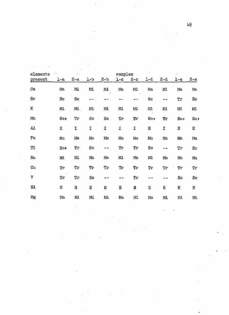
Spectrographic Analysis of Tuffs and Lavas
The following table is a spectrographic analysis of tuff and
lava samples collected in the thesis area. The results of this
analysis were not included in the text of- this thesis but are here included as reference data for anyone desiring a spectrographic comparison with tuffs and leavas in other localities.
The tuff beds which were mapped as recognizable units in the field were selected for analysis. The tuff samples are des- isnated by a number and by a letter. The numbers represent the
locality in which the samples were collected. Those samples possess
ing the same letter are from the same tuff bed. Tuff bed "a" is
lowest in the section and each successive tuff map unit is designated by a successive letter. .
The dacite sample and tuff samples 1-a and 1-b were collected
on the north flank of Black Mountain in the NW- NW- - sec. 12. Samples1- c, 1-d, 1-e, 1-f, and 1-g' were collected along Milk Creek between
the P Bar Ranch and Pole Camp Canyon. Samples 2-a, 2-b, 2-c, 2-d,
2- e, and 2-f were collected in the canyon southeast of Shields' Ranch
where the stratigraphic section was measured. The basalt sample was| collected west of Shields’ Ranch.

Key for Symbols
Group 1. Those elements dominating or characterizing the rock type,
examplea. H- high free quartz
I- intermediate silicates but no free quartzL- low not completely silicated
Group 2. Those elements that strongly influence the mineralogy of the rock.
exampleK which would form orthoclase or Na which would form albite
Group 3. Those elements present in amounts not directly apparent in the mineralogy.
examplea. Sc- scarce: elements which replace
Tr- trace essential elements in thecrystal lattice
a. Ma- major Mi- minor
Speciments to be shot at $0 volts and 9 amperes for 35 seconds.
48
elements samplespresent 1-a 2-a 1-13 2-"b 1-c 2-c 1-d 2-a 1-e 2-eCa Ma Mi Mi Mi Ma Mi Ma Mi Ma MaSr Sc Sc Sc — Tr ScK Mi Mi. Mi Mi Mi Mi Mi Mi Mi MiMn Scf Tr Sc Sc Tr Tr Sc+ Tr Set Sc+A1 H. I I I I I H I H HFe Ma Ma Ma Ma Ma Ma Ma Ma Ma MaTi Set Tr Sc — Tr Tr Sc — Tr ScNa Mi Mi Ma Ma Mi Ma Mi Ma Ma MaCu Tr Tr Tr Tr Tr Tr Tr Tr Tr TrV Tr Tr Sc - - — - Tr — - — Sc ScSi H H H H H H H E H HMg Ma Mi Mi. Mi Ma Mi Ma Mi Mi Mi

elementspresent 1-f 2-f
samples1-g dacite basalt
Cr Tr MaCa Ma Mi Ma Ma MaSr Tr — - Tr — TrK Mi ' - — Mi Mi MiMn Sc — Sc Sc Sc*A1 H I H I IFe Ma Ma Ma Ma Ma
Ti Sc — — Sc Tr Mim MiNa Mi Ma Mi Ma MaCo TrCu Tr Tr Tr Mi MaV — Tr — Tr ScSi H H H H HMg Ma Mi Ma Mi MaAs — TrSb Tr
Univ. of Arizona Library

PLATE 2
Fig. 1. Looking south at the southeast end ofBlack Mountain.Soil covered flatlands in the foreground.
Fig. 2. Looking southeast at the Bradshaw Mountains. Soilvcovered flatlands in the foreground.
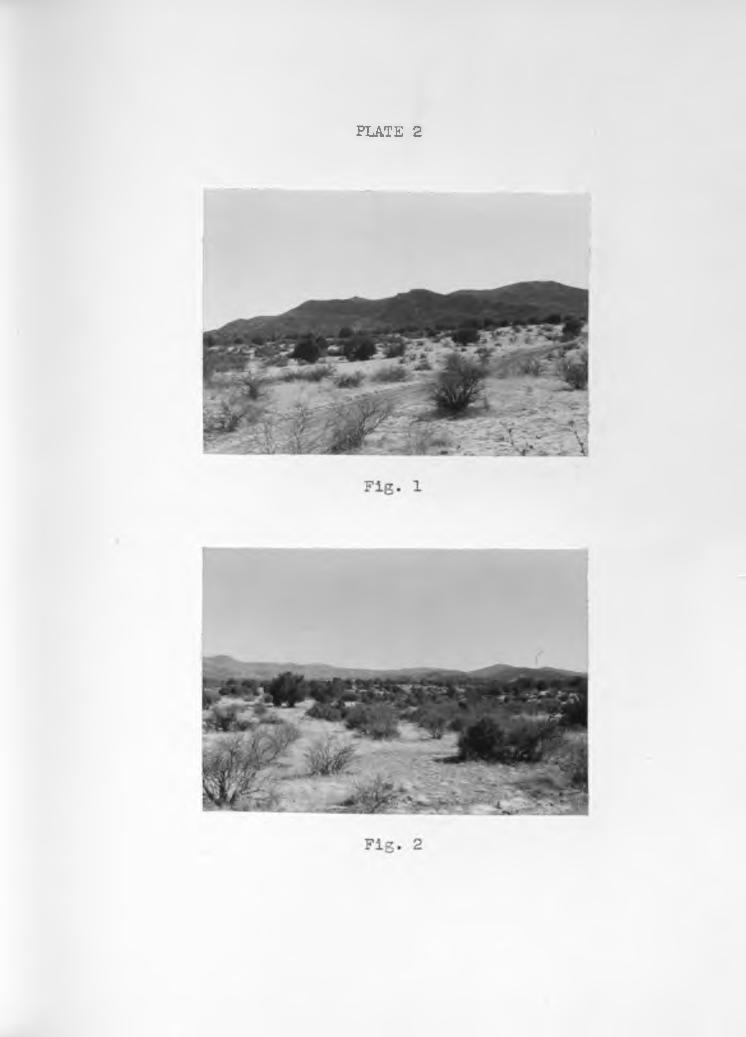
PLATE 2

PLATE 3
Fig. 1. Looking southeast. Milk Creek in the foreground and Bradshaw Mountains in the background. Gently- dipping lake sediments in middle distance with conglomerate cliff at left skyline.
Fig. 2. Southeast of Shields’ Ranch. Gently dipping, resistant tuff bed with a badland cliff below.

PLATE 3
Fig. 2

PLATE 4
Pig. 1. Southeast of Shields1 Ranch. Badland topography and pedestal rocks. White tuffs and resistant sandstone layers in the cliffs.
Fig. 2. Southeast of Shields' Ranch. A layer of volcanicbombs (note the roundness and number of small bombs) Hard, resistant sandstone and tuff beds dip WE in the badland cliff in the background.

PLATE 4
z

PLATE 5
Fig. 1. Cross-bedding in the Upper member of the Milk Creek formation.
Fig. 2. Close-up of an erosion surface truncating cross bedded strata in the Upper member. Erosion surface extends from lower left corner to upper right corner of picture.

PLATE 5
Fig. 2

PLATE 6
Fig. 1. Typical exposure of the Upper member of the Milk Creek formation in the cross-bedded zone. Crossbedding not distinctly shown.
Fig. 2. Another typical view of the Upper member. Mild -cross-bedding in the cliff in the center of the picture.

Fig. 1
F i g 2

PLATE 7
Fig. 1. Conglomerate cliff overlying the cross-bedded zone. Badland cliffs in the right background.
Fig. 2. Looking northeast across Milk Creek. Massivesandstone cliffs of the non-cross-bedded,part of Upper member in the middle distance with conglomerate cliff and hills beyond.

I
,
Fig. 2

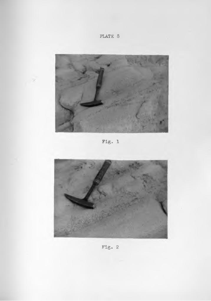
PLATE 8
Fig. 1. Granule lenses in the foresets of the Uppermember of the Milk Creek formation. Note the. cross-bedding.
Fig. 2. Granule and coarse-grained sand lens in the foresets of the Upper member.
P L A T E 8
Fig. 1
Fig. 2

PLATE 9
Fig. 1. Graded bedding in the foreset beds of the Upper member of the Milk Creek formation.
Fig. 2. Graded bedding and granule lenses in the foresets of the Upper member of the Milk Creek formation.

P L A T E 9
Fig. 1
;V*
Fig. 2

PLATE 10
Fig. 1. Southeast of Shields’ Ranch. Amphitheater-like depression showing gently dipping Lower Pliocene sediments which are overlain unconformably by Pleistocene (?) rocks. The dark splotches in the center of the picture are volcanic bombs.
Fig. 2. Southeast of Shields' Ranch. Gently dipping resistant, white tuff with pronounced angular unconformity in background.

P L A T E 10
Fig. 1
Fig. 2

REFERENCES CITED
Jaggar, T. A., Jr., and Palache, Charles (1905) Bradshaw Mountains, U. S. Geol. Survey, Folio no. 126
Lahee, Frederic .H. (1952) Field Geology, p. 88-92, McGraw- Hill Book Company
Longwell, C. R. (19^6) How Old is the Colorado River?,Am. Jour. Sci., vol. 244, p. 017-035 :
McKee, E. D. (1951) Sedimentary Basins of Arizona andAdjoining Areas, Geol. Soc. Am., Bull., vol. 62, p. 451-506
Plafker, Lloyd (1956) Unpublished Master's Thesis,University of Arizona
Ransome, F. L. (1903) Geology of the Globe Copper District. Arizona, U. S. Geol. Survey Prof. Paper 12
_______ (1919) Copper Deposits of Ray and Miami, Arizona,U. S. Geol. Survey Prof. Paper 115
Reed, Charles A. (1950) A Preliminary Announcement of a New Mammalian Fossil Locality in the Pliocene or Arizona, Plateau, vol. 22. no. 4. p. 75-77
Wilson, Eldred D. (1952) Arizona Gold Placers and Placering, Ariz. State Bur. Mines, Bull., no. 160, p. 52, 5*+-55

T /2 V T / / N
7 /r.p
'j/uUt
!///,/
'
i ' ! I •
/ z /V ( z/ / I / , ,
A cr\ i «
\ /. 1
D . U
z> •'z / /
\
_____ L
4 v r> ;
• X \/4 A//4 7 - / 0 A /
RocksS e o / i m e n i a r y
rtctnf alluvium
t e r r a c e j r a v e / s a n d r e c e n t so/fa Y u n d / f f e r e n t i a f e a / )
f a k e s e d /m e n t s , c /a y a n d a r y i / / a c e o u s s i l t ’ 1 V {
M Xf / o o d - p l a in c o n y to nt e r a t e a n d c o a r s e - y r a i n e d s a n d s t o n e
c o n y to m e r a t e a n d f any /o m e r a te ( u n d i f f e r e n t i a t e d )
u p p e r m e m b e r , c /e / ta ic s a n d s t o n e , S f / / s f o n e y /o c a / to c ross ~ b e d d e d
m/ddte. m ember^ m terbedded sandstone si/Zstone t t u f f , Uo/canic bombs
a d
/om e rate ands a n d s /o n e
lofneous Rocks
n o rm a l f a u l t shouting dip and re /a t /ve d / s p / a c e m e n t — d a s h t w h ere i n f e r r e d , d o t te d where c ore r e d
'y p/uny
GEOLOGIC MAPOF A P A R T OF THE
W W / . M / 7 - < ; / ? 0 1 / E 8 / 4 t S / / VTopocyraphij : U.S. Geo/oyica/ Survey K irkland / /V / Union Q uadrany/es Geo/oyty : D o n a /d L. tdook Sum mer /9SS
• /* o / e w
Scale : / /y = / 000 '

Univ. of Arizona Library
3</
1

B a s a / f R io /qe F a u l i
P L A T E \2
S ca le : / " = 1000' N o rm a l Scale

Univ. of Arizona Library

PLATE 13
C O L U M N A R S E C T I O No f the
M ilk C r e t k Formation
Scale: /" = 5o'
unit thickness
vS
-QIV)OV.U
. . . ' • . / V * t ... *; '-w V W J iV -r '" -
X-:
i e» • • .O ■• *<M«**‘»*i »' . ‘ V. . W, \
c . v r"- * . •: * • ..Z7
/Z
a
f:
i*:4j :
zI?'
/4v'/J-'
i;
T • .%_
---- 1
o - . °
r u i
ar/f
o ver la y mJf cafes a r y / ffcrC to u s m a f ' e r / a l
faiff l a y e r s soZ /c / o o /o r , co nye nr/orta !
o t h e r s y m b o l s