uav for 3d mapping applications: a review - fbk |...
TRANSCRIPT

UAV for 3D mapping applications: a review
Francesco Nex, Fabio Remondino
F. Nex
3D Optical Metrology Unit, Bruno Kessler Foundation (FBK), Trento, Italy
+39 0461 314615
+39 0461 314340
http://3dom.fbk.eu/
F. Remondino
3D Optical Metrology Unit, Bruno Kessler Foundation (FBK), Trento, Italy
+39 0461 314914
+39 0461 314340
http://3dom.fbk.eu/
Keywords UAV, photogrammetry, DSM, archaeology, agriculture, emergency, urban
Abstract Unmanned Aerial Vehicle (UAV) platforms are nowadays a valuable source of data for
inspection, surveillance, mapping and 3D modeling issues. As UAVs can be considered as a low-
cost alternative to the classical manned aerial photogrammetry, new applications in the short- and
close-range domain are introduced. Rotary or fixed wing UAVs, capable of performing the
photogrammetric data acquisition with amateur or SLR digital cameras, can fly in manual, semi-
automated and autonomous modes. Following a typical photogrammetric workflow, 3D results like
Digital Surface or Terrain Models (DTM/DSM), contours, textured 3D models, vector information,
etc. can be produced, even on large areas. The paper reports the state of the art of UAV for
Geomatics applications, giving an overview of different UAV platforms, applications and case
studies, showing also the latest developments of UAV image processing. New perspectives are also
addressed.
Introduction
According to the UVS (Unmanned Vehicle System) International definition, an Unmanned Aerial
Vehicle (UAV) is a generic aircraft design to operate with no human pilot onboard
(http://www.uvs-international.org/). The simple term UAV is used commonly in the Geomatics

community, but also other terms like Drone, Remotely Piloted Vehicle (RPV), Remotely Operated
Aircraft (ROA), Micro Aerial Vehicles (MAV), Unmanned Combat Air Vehicle (UCAV), Small
UAV (SUAV), Low Altitude Deep Penetration (LADP) UAV, Low Altitude Long Endurance
(LALE) UAV, Medium Altitude Long Endurance (MALE) UAV, Remote Controlled (RC)
Helicopter and Model Helicopter are often used, according to their propulsion system,
altitude/endurance and the level of automation in the flight execution. The term UAS (Unmanned
Aerial System) comprehends the whole system composed by the aerial vehicle/platform (UAV) and
the Ground Control Station (GCS). [Sanna and Pralio, 2005] defines UAVs as Uninhabited Air
Vehicles while [Von Blyenburg, 1999] defines UAVs as uninhabited and reusable motorized aerial
vehicles.
In the past, the development of UAV systems and platforms was primarily motivated by military
goals and applications. Unmanned inspection, surveillance, reconnaissance and mapping of inimical
areas were the primary military aims. For Geomatics applications, the first experience was carried
out three decades ago but only recently UAVs in the Geomatics field became a common platform
for data acquisition. UAV photogrammetry (Colomina et al., 2008; Eisenbeiss, 2009) indeed opens
various new applications in the close-range aerial domain, introducing a low-cost alternative to the
classical manned aerial photogrammetry for large-scale topographic mapping or detailed 3D
recording of ground information and being a valid complementary solution to terrestrial acquisitions
(Fig.1). The latest UAV success and developments can be explained by the spreading of low-cost
platforms combined with amateur or SRL digital cameras and GNSS/INS systems, necessary to
navigate the platforms, predict the acquisition points and possibly perform direct geo-referencing.
Although conventional airborne remote sensing has still some advantages and the tremendous
improvements of very high-resolution satellite imagery are closing the gap between airborne and
satellite mapping applications, UAV platforms are a very important alternative and solution for
studying and exploring our environment, in particular for heritage locations or rapid response
applications. Private companies are now investing and offering photogrammetric products (mainly
DSM - and orthoimages) from UAV-based aerial images as the possibility of using flying
unmanned platforms with variable dimensions, small weight and high ground resolution allow to
carry out flight operations at lower costs compared to the ones required by traditional aircrafts.
Problems and limitations are still existing, but UAVs are a really capable source of imaging data for
a large variety of applications.
The paper reviews the most common UAV systems and applications in the Geomatics field,
highlighting open problems and research issues related to regulations and data processing. The
entire photogrammetric processing workflow is also reported with different examples and critical
remarks.
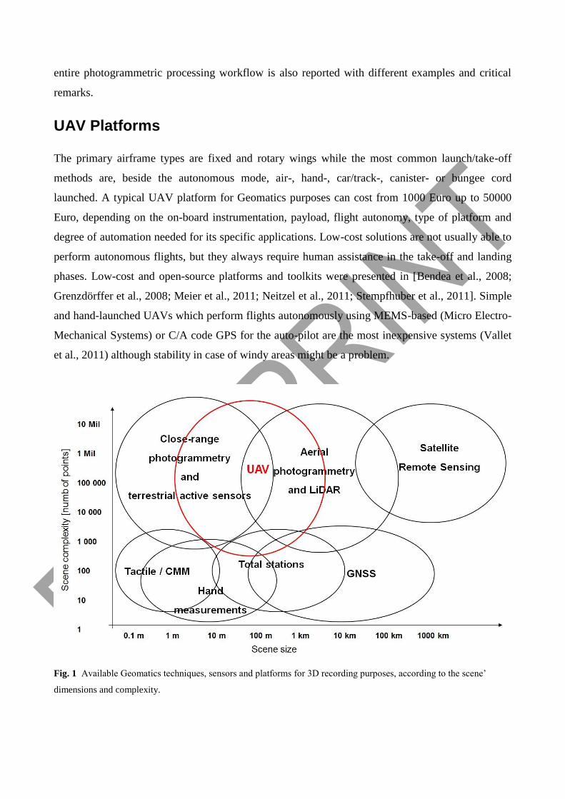
UAV Platforms
The primary airframe types are fixed and rotary wings while the most common launch/take-off
methods are, beside the autonomous mode, air-, hand-, car/track-, canister- or bungee cord
launched. A typical UAV platform for Geomatics purposes can cost from 1000 Euro up to 50000
Euro, depending on the on-board instrumentation, payload, flight autonomy, type of platform and
degree of automation needed for its specific applications. Low-cost solutions are not usually able to
perform autonomous flights, but they always require human assistance in the take-off and landing
phases. Low-cost and open-source platforms and toolkits were presented in [Bendea et al., 2008;
Grenzdörffer et al., 2008; Meier et al., 2011; Neitzel et al., 2011; Stempfhuber et al., 2011]. Simple
and hand-launched UAVs which perform flights autonomously using MEMS-based (Micro Electro-
Mechanical Systems) or C/A code GPS for the auto-pilot are the most inexpensive systems (Vallet
et al., 2011) although stability in case of windy areas might be a problem.
Fig. 1 Available Geomatics techniques, sensors and platforms for 3D recording purposes, according to the scene’
dimensions and complexity.

More bigger and stable systems, generally based on an Internal Combustion Engine (ICE), have
longer endurance with respect to electric engine UAVs and, thanks to the higher payload, they
allow medium format (reflex) camera or LiDAR or SAR instruments on-board (Nagai et al., 2004;
Vierling et al., 2006; Wang et al., 2009; Berni et al, 2009; Kohoutek and Eisenbeiss, 2012;
Grenzdoffer et al. 2012).
The developments and improvements at hardware and platform levels are done in the robotics,
aeronautical and optical communities where breakthrough solutions are sought in order to
miniaturize the optical systems, enhance the payload, achieve complete autonomous navigation and
improve the flying performances (Huckridge and Ebert, 2008; Schafroth et al. 2009). Researches
are also performed studies on flying invertebrates to understand their movement capabilities,
obstacle avoidance or autonomous landing/takeoff capabilities (Franceschini et al. 2007; Moore et
al., 2008). Based on size, weight, endurance, range and flying altitude, UVS International defines
three main categories of UAVs:
- Tactical UAVs which include micro, mini, close-, short-, medium-range, medium-range
endurance, low altitude deep penetration, low altitude long endurance, medium altitude long
endurance systems. The mass varies from few kg up to 1,000 kg, the range from few km up
to 500 km, the flight altitude from few hundreds meter to 5 km and the endurance from
some minutes to 2-3 days.
- Strategical UAVs, including high altitude long endurance, stratospheric and exo-
stratospheric systems which fly higher than 20,000 m altitude and have an endurance of 2-4
days.
- Special tasks UAVs like unmanned combat autonomous vehicles, lethal and decoys systems.
UAVs for Geomatics applications can be shortly classified according their engine/propulsion
system in:
- unpowered platforms, e.g. balloon, kite, glider, paraglide;
- powered platforms, e.g. airship, glider, propeller, electric, combustion engine.
Alternatively, they could be classified according to the aerodynamic and “physical” features as:
- lighter-than-air, e.g. balloon, airship;
- rotary wing, either electric or with combustion engine, e.g. single-rotor, coaxial,
quadrocopter, multi-rotor;
- fixed wing, either unpowered, electric or with internal combustion engine (ICE), e.g. glider
or high wing.

Table 1. Evaluation of some UAV platforms employed for Geomatics applications, according to the literature and the
authors’ experience. The evaluation is from 1 (low) to 5 (high).
Kite / Balloon Fixed Wing Rotary wings
electric ICE engine electric ICE engine
Payload 3 3 4 2 4
Wind resistance 4 2 3 2 4
Minimum speed 4 2 2 4 4
Flying autonomy - 3 5 2 4
Portability 3 2 2 3 3
Landing distance 4 3 2 4 4
In table 1, pros and cons of different UAV typologies are presented, according to the literature
review and the authors’ experience: rotor and fixed wing UAVs are compared to more traditional
aerial low-cost kite and balloons.
UAV applications in Geomatics
Some UAVs civilian applications are mentioned in [Niranjan et al. 2007] while [Everaerts, 2008]
reports on UAV projects, regulations, classifications and application in the mapping domain. The
application fields where UAVs images and photogrammetrically derived DSM or orthoimages are
generally employed include:
- Agriculture: producers can take reliable decisions to save money and time (e.g. precision
farming), get quick and accurate record of damages or identify potential problems in the field
(Newcombe, 2007).
- Forestry: assessments of woodlots, fires surveillance, vegetation monitoring, species
identification, volume computation as well as silviculture can be accurately performed
(Grenzdörffer, 2008; Martinez et al., 2006; Réstas, 2006; Berni et al., 2009).
- Archaeology and architecture: 3D surveying and mapping of sites and man-made structures can
be performed with low-altitude image-based approaches (Çabuk, et al.,2007; Lambers et al.,
2007; Oczipka et al., 2009; Verhoeven, 2009; Chiabrando et al., 2011; Rinaudo et al., 2012).
- Environment: quick and cheap regular flights allow the monitoring of land and water at multiple
epochs (Thamm and Judex, 2006; Niethammer et al., 2010), road mapping (Zhang, 2008),
cadastral mapping (Manyoky et al., 2011), thermal analyses (Hartmann et al., 2012), excavation

volume computation, volcano monitoring (Smith et al., 2009), coastline monitoting or natural
resources documentations for geological analyses are also feasible.
- Emergency management: UAV are able to quickly acquire images for the early impact
assessment and the rescue planning (Chou et al., 2010; Haarbrink and Koers, 2006; Molina et al.,
2012). The flight can be performed over contaminated areas without any danger for operators or
any long pre-flight operations.
- Traffic monitoring: surveillance, travel time estimation, trajectories, lane occupancies and
incidence response are the most required information (Puri et al., 2007).
UAV images are also often used in combination with terrestrial surveying in order to close possible
3D modeling gaps and create orthoimages (Pueschel et al., 2008; Remondino et al., 2009). UAVs
can be adopted for industrial applications too (i.e. air pollution monitoring, surveillance, surveying,
etc.).
Historical framework and regulations
UAVs were originally developed for military applications, with flight recognition in enemy areas,
without any risk for human pilots. The first experiences for civil and Geomatics applications were
carried out at the end of the 70’s (Przybilla et al, 1979) and their use greatly increased in the last
decades thanks to the fast improvement of platforms, communication technologies and software as
well as the growing number of possible applications. Thus the use of such flying platforms in civil
applications imposed to increase the security of UAV flights in order to avoid dangers for human
beings. The international community started to define the security criteria for UAV some years ago.
In particular, NATO and EuroControl started their cooperation in 1999 in order to prepare
regulations for UAV platforms and flights. This work did not lead to a common and international
standard yet, especially for civil applications. But the great diffusion and commercialization of new
UAV systems has pushed several national and international associations to analyse the operational
safety of UAVs. Each country has one or more authorities involved in the UAV regulations, that
operates independently. Due to the absence (at least in the past) of a cooperation between all these
authorities, it is difficult to describe the specific aims of each of them without loss of generality. In
table 2, a schematic summary of the already existing regulations in several countries is presented.
The elements of UAV regulations are mainly keen to increase the reliability of the platforms,
underlining the need for safety certifications for each platform and ensuring the public safety. As
they are conditioned by technical developments and safety standards, rules and certifications should

be set equal to those currently applied to comparable manned aircraft, although the most important
issue, being UAVs unmanned, it is the citizens security in case of an impact.
UAVs have currently different safety levels according to their dimension, weight and on board
technology. For this reason, the rules applicable to each UAV could not be the same for all the
platforms and categories. For example, in U.S., the safety is defined according to their use (public
or civic), in some European countries according to the weight, as this parameter is directly
connected to the damage they can produce when a crash occurs. Other restrictions are defined in
terms of minimum and maximum altitude, maximum payload, area to be surveyed, GCS-vehicle
connection (i.e. visual or radio), etc. The indirect control of a pilot from the GCS may lead to
increased accidents due to human errors. For this reason, in several countries UAV operators need
some training and qualifications.
Table 2. Regulations for UAS use in several countries.
Regulation for civil use of UAS (laws and regulations)
Australia CASA Circular, Juli 2002
Belgium Certification Specification, Rev. 00, 24.01.07
Canada Approach to the Classification of Unmanned Aircraft, 19.10.10
Denmark Regulations on unmanned aircraft not weighing more than 25 kg-, Edition 3, 09.01.04
France Decree concerning the design of civil aircraft fly without anyone on board, August 2010
Great Britain CAP 722, 06.04.10 u. Joint Doctrin 2/11, 30.3.11
Norway Operation of unmanned aircraft in Norway, 29.06.09
Sweden Flying with UAVs in airspace involving civil aviation activity, 25.03.03
Switzerland Verordnung des UVEK über Luftfahrtzeuge besonderer Kategorien, 01.04.11
Czech Czech aviation regulation L2 - Rules of the air, 25.08.11
USA UAS Certification Status, 18.08.08; Fact Sheet - Unmanned Aircraft Systems, 15.7.10 und
NJO7210.766, 28.3.11, 8.2.12 und FAA Bill
Anyway, in the last few months the European Community has announced the beginning of three
different “Roadmaps” in the field of R&D, complementary measures and safety regulations of the
UAVs. This work will define common rules at EU level with the aim of defining a full integration
of UAVs in the European Aviation system. This process is collecting the contributions of many
stakeholders from several EU countries and consists of several steps and deliverables. The UAV
flights will be divided in different categories according to the flying height and the strategy adopted
to control the platform from the GCS (i.e. visual line-of-sight, radio line-of-sight, etc.) to define
different regulations and technical prescriptions. The road maps, started in 2013, will be completed
in 2028. For more information refer to (http://ec.europa.eu/enterprise/sectors/aerospace/uas/).

UAV data acquisition and processing
A typical image-based aerial surveying with an UAV platform requires a flight or mission planning
and GCPs (Ground Control Points) measurement (if not already available) for geo-referencing
purposes. After the acquisitions, images can be used for stitching and mosaicking purposes (Neitzel
and Klonowski, 2009), or they can be the input of the photogrammetric process. In this case,
camera calibration and image triangulation are initially performed, in order to generate successively
a Digital Surface Model (DSM) or Digital Terrain Model (DTM). These products can be finally
used for the production of ortho-images, 3D modelling applications or for the extraction of further
metric information. In Fig. 2, the general workflow is shown: the input parameters are in green,
while the single workflow steps are in yellow and they are discussed more in detail in the following
sections.
Fig. 2 Typical acquisition and processing pipeline for UAV images.
Flight planning and image acquisition
The mission (flight and data acquisition) is normally planned in the lab with dedicated software,
starting from the knowledge of the area of interest (AOI), the required Ground Sample Distance
(GSD) or footprint and the intrinsic parameters of the on-board digital camera. The desired image
scale and used camera focal length are generally fixed in order to derive the mission flying height.
The camera perspective centers (“waypoints”) are computed fixing the longitudinal and transversal
overlap of the strips (e.g. 80%-60%). All these parameters vary according to the goal of the flight:
missions for detailed 3D model generation usually request high overlaps and low altitude flights to
achieve small GSDs, while quick flights for emergency surveying and management need wider
areas to be recorded in few minutes, at a lower resolution.
The flight is normally done in manual, assisted or autonomous mode, according to the mission
specifications, platform’s type and environmental conditions. The presence onboard of GNSS/INS
navigation devices is usually exploited for the autonomous flight (take-off, navigation and landing)
and to guide the image acquisition. The image network quality is strongly influenced by the
typology of the performed flight (Fig. 3): in the manual mode, the image overlap and the geometry
of acquisition is usually very irregular, while the presence of GNSS/INS devices, together with a
navigation system, can guide and improve the acquisition. The navigation system, generally called
auto-pilot, is composed by both hardware (often in a miniaturize form) and software devices. An
auto-pilot allows to perform a flight according the planning and communicate with the platform
during the mission. The small size and the reduced payload of some UAV platforms is limiting the
transportation of high quality navigation devices like those coupled to airborne cameras or LiDAR
sensors. The cheapest solution relies on MEMS-based inertial sensors which feature a very reduced
weight but accuracy not sufficient, to our knowledge, for direct geo-referencing (DeAgostino et al.,
2010; Piras et al., 2010). More advanced and expensive sensors, maybe based on single/double
frequency positioning mode or the use of RTK would improve the quality of positioning to a
decimetre level, but they are still too expensive to be commonly used on low-cost solutions. During
the flight, the autonomous platform is normally observed with a Ground Control Station (GCS)
which shows real-time flight data such as position, speed, attitude and distances, GNSS
observations, battery or fuel status, rotor speed, etc. On the opposite, remotely controlled systems
are piloted by operator from the ground station. Most of the systems allow then image data
acquisition following the computed waypoints while low-cost systems acquire images with a
scheduled interval. The used devices (platform, auto-pilot and GCS) are fundamental for the quality
and reliability of the final result: low-cost instruments can be sufficient for little extensions and low
altitude flights, while more expensive devices must be used for long endurance flights over wide
areas. Generally, in case of light weight and low-cost platforms, a regular overlap in the image
block cannot be assured as there are strongly influenced by the presence of wind, piloting
capabilities and GNSS/INS quality, all randomly affecting the attitude and location of the platforms
during the flight. Thus higher overlaps, with respect to flights performed with manned vehicles or
very expensive UAVs, are usually recommended to keep in count these problems.

Fig. 3 Different modalities of the flight execution delivering different image block’s quality: a) manual mode and
image acquisition with a scheduled interval; b) low-cost navigation system with possible waypoints but irregular image
overlap; c) automated flying and acquisition mode achieved with a high quality navigation system.
Camera calibration and image orientation
Camera calibration and image orientation are two fundamental prerequisites for any metric
reconstruction from images. In metrological applications, the separation of both tasks in two
different steps should be preferred (Remondino and Fraser, 2006). Indeed, they require different
block geometries, which can be better optimized if they are treated in separated stages. On the other
hand, in many applications where lower accuracy is required, calibration and orientation can be
computed at the same time by solving a self-calibrating bundle adjustment. In case of aerial
cameras, the camera calibration is generally performed in the lab although in-flight calibration are
also performed (Colomina et al., 2007), possibly with strips at different flying heights. Camera
calibration and image orientation tasks require the extraction of common features visible in as many
images as possible (tie points) followed by a bundle adjustment, i.e. a non-linear optimization
procedure in order to minimize an appropriate cost function (Brown, 1976; Triggs et al., 2000;
Gruen and Beyer, 2001). Procedure based on the manual identification of tie points by an expert
operator or based on signalized coded markers are well assessed and used today. Recently fully
automated procedures for the extraction of a consistent and redundant sets of tie points from
markerless close-range images have been developed for photogrammetric applications (Barazzetti et
al., 2011; Pierrot-Deseilligny and Clery, 2011). Some efficient commercial solutions have also
appeared on the market (e.g. PhotoModeler Scanner, Eos Inc; PhotoScan, Agisoft) while
commercial software for aerial applications still need some user interaction or the availability of
GNSS/INS data for automated tie points extraction. In Computer Vision, the simultaneous
determination of camera (interior and exterior) parameters and 3D structure is normally called
“Structure from Motion” (Hartley and Zisserman, 2004; Snavely et al., 2008; Robertson and
Cipolla, 2009). Some free web-based approaches (e.g. Photosynth, 123DCatch, etc.) and open
source solutions (VisualSfM (Wu, 2011) Bundler (Snavely et al., 2007), etc.) are also available
although generally not reliable and accurate enough in case of large and complex image blocks with
variable baselines and image scale. The employed bundle adjustment algorithm must be reliable,
able to handle possible outliers and provide statistical outputs to validate the results. The collected
GNSS/INS data, if available, can help for the automated tie point extraction and can allow the direct
geo-referencing of the captured images. In applications with low metric quality requirements, e.g.
for fast data acquisition and mapping during emergency response, the accuracy of direct GNSS/INS
observation can be enough (Pfeifer et al., 2009; Zhou, 2009).
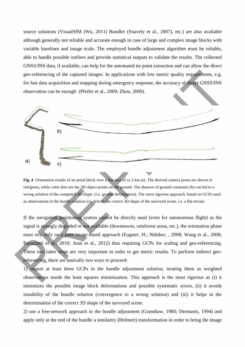
Fig. 4 Orientation results of an aerial block over a flat area of ca 2 km (a). The derived camera poses are shown in
red/green, while color dots are the 3D object points on the ground. The absence of ground constraint (b) can led to a
wrong solution of the computed 3D shape (i.e. ground deformation). The more rigorous approach, based on GCPs used
as observations in the bundle solution (c), deliver the correct 3D shape of the surveyed scene, i.e. a flat terrain.
If the navigation positioning system cannot be directly used (even for autonomous flight) as the
signal is strongly degraded or not available (downtowns, rainforest areas, etc.), the orientation phase
must rely only on a pure image-based approach (Eugster, H.; Nebiker, , 2008; Wang et al., 2008;
Barazzetti et al., 2010; Anai et al., 2012) thus requiring GCPs for scaling and geo-referencing.
These two latter steps are very important in order to get metric results. To perform indirect geo-
referencing, there are basically two ways to proceed:
1) import at least three GCPs in the bundle adjustment solution, treating them as weighted
observations inside the least squares minimization. This approach is the most rigorous as (i) it
minimizes the possible image block deformations and possible systematic errors, (ii) it avoids
instability of the bundle solution (convergence to a wrong solution) and (iii) it helps in the
determination of the correct 3D shape of the surveyed scene.
2) use a free-network approach in the bundle adjustment (Granshaw, 1980; Dermanis, 1994) and
apply only at the end of the bundle a similarity (Helmert) transformation in order to bring the image
network results into a desired reference coordinate system. This approach is not rigorous: the
solution is sought minimizing the trace of the covariance matrix, introducing the necessary datum
with some initial approximations. As no external constraint is introduced, if the bundle solution
cannot determine the right 3D shape of the surveyed scene, the successive similarity transformation
(from the initial relative orientation to the external one) would not improve the result. The two
approaches, in theory, are thus not equivalent and they can lead to totally different results (Fig. 4):
in the first approach, the quality of the bundle is only influenced by the redundant control
information and, moreover, additional check points can be used to derive some statistics of the
adjustment. On the other, the second approach has no external shape constraints in the bundle
adjustment thus the solution is only based on the integrity and quality of the multi-ray relative
orientation. The fundamental requirement is thus to have a good image network in order to achieve
correct results in terms of computed object coordinates and scene’s 3D shape.
Surface reconstruction and orthoimage generation
Once a set of images has been oriented, the following steps in the 3D reconstruction and modeling
workflow are the surface measurement, orthophoto creation and feature extraction. Starting from
the known camera orientation parameters, a scene can be digitally reconstructed by means of
interactive procedures or automated dense image matching techniques. The output is normally a
sparse or a dense point cloud, describing the salient corners and features in the former case or the
entire surface’s shape of the surveyed scene in the latter case. Dense image matching algorithms
should be able to extract dense point clouds to define the object’s surface and its main geometric
discontinuities.
Therefore the point density must be adaptively tuned to preserve edges and, possibly, avoid too
many points in flat areas. At the same time, a correct matching result must be guaranteed also in
regions with poor textures. The actual state-of-the-art is the multi-image matching technique (Seitz
et al., 2006; Vu et al., 2009; Zhu et al., 2010) based on semi-global matching algorithms (Gerke et
al., 2010; Hirschmüller, 2008), patch-based methods (Furukawa, 2010) or optimal flow algorithms
(Pierrot-Deseilligny and Paparoditis, 2006). The last two methods has been implemented into open
source packages named, respectively, PMVS and MicMac.
The derived unstructured point clouds need to be afterwards structured and interpolated, maybe
simplified and finally textured for photo-realistic visualization. Dense point clouds are generally
preferred in case of terrain/surface reconstruction (e.g. archaeological excavation, forestry area,
etc.) while sparse clouds which are afterward turned into simple polygonal information can be
preferred when modeling man-made scenes like buildings. For the creation of orthoimages, a dense

point cloud is mandatory in order to achieve precise ortho-rectification and for a complete removal
of terrain distortions. On the other hand, in case of low-accuracy applications (e.g. rapid response,
disaster assessment, etc.) a simple image rectification method (without the need of dense image
matching) can be applied followed by a stitching operation (Neitzel and Klonowski, 2011).
Case Studies
As already mentioned, images acquired flying UAV platforms give useful information for different
applications, such as archaeological documentation, geological studies and monitoring, urban area
modeling and monitoring, emergency assessment and so on. The typical required products are dense
point clouds, polygonal models or orthoimages which are afterwards used for mapping, volume
computation, displacement analyses, visualization, city modeling, map generation, etc.. In the
following sections an overview of some applications is given and the achieved results are shown.
The data presented in the following case studies were acquired by the authors or by some project
partners and they were processed by the authors using the Apero (Pierrot-Deseilligny and Clery,
2011) and Mic-Mac (Pierrot-Deseilligny and Paparoditis, 2006) open-source tools customized for
specific UAV applications.
Archaeological site 3D recoding and modeling
The availability of accurate 3D information is very important during excavation in order to define
the state of works/excavations at a particular epoch or to digitally reconstruct the findings that had
been discovered for documentation, digital preservation and visualization purposes. An example of
such application is given in Fig. 5, where the Neptune Temple in the archaeological area of Paestum
(Italy) is shown. Given the shape, complexity and dimensions of the monument, a combination of
terrestrial and UAV (vertical and oblique) images was employed in order to guarantee the
completeness of the 3D surveying work. The employed UAV is a 4-rotors MD4-1000 Microdrone
system, entirely of carbon fibre which can carry up to 1,0 kg instruments with an endurance longer
than 45 minutes. For the nadir images, the UAV mounted an Olympus E-P1 camera (12
Megapixels, 4.3 µm pixel size) with 17 mm focal length while for the oblique images it was used an
Olympus XZ-1 (10 Megapixels, 2 µm pixel size) with 6 mm focal length. For both flights, the
average GSD of the images is ca 3 cm. The auto-pilot system allowed to perform two complete
flights in autonomous mode, but the stored coordinates of the projection centres were not sufficient
for direct geo-referencing. For this reason, a set of reliable GCPs (measured with total station on
corners and features of the temple) was necessary to derive scaled and geo-referenced 3D results.
The orientation procedure was finally completed adding terrestrial to UAV images (ca 190) and

orienting the whole dataset simultaneously in order to bring all the data in the same coordinate
system. After the recovery of the camera poses, a DSM was produced for documentation and
visualization purposes (Fiorillo et al., 2012).
Fig. 5 Integration of terrestrial images (a) with oblique (b) and vertical (c) UAV acquisitions for the surveying and
modeling of the complex Neptune temple in Paestum, Italy. The integrated adjustment for the derivation of the camera
poses of all the images (d, e) in a unique reference system.
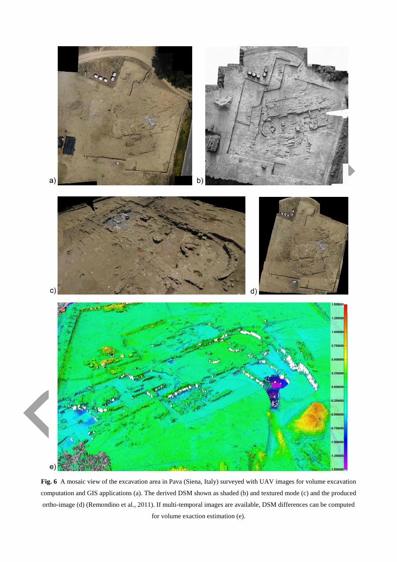
Fig. 6 A mosaic view of the excavation area in Pava (Siena, Italy) surveyed with UAV images for volume excavation
computation and GIS applications (a). The derived DSM shown as shaded (b) and textured mode (c) and the produced
ortho-image (d) (Remondino et al., 2011). If multi-temporal images are available, DSM differences can be computed
for volume exaction estimation (e).
A second example is reported in Fig. 6, showing the archaeological area of Pava (ca 60 x 50 m)
surveyed every year at the beginning and end of the excavation period to monitor the advances of
the work, compute the exaction volume and produce multi-temporal orthoimages of the area. The
flights (35 m height) were performed with a Microdrone MD4-200 in 2010 and 2011. The heritage
area is quite windy, so an electric platform was probably not the most suited one. For each session,
using multiple shootings for each waypoint, a reliable set of images (ca 40) was acquired, with an
average GSD of 1 cm.
In order to evaluate the quality of the image triangulation procedure, some circular targets,
measured with a total station, are used as ground control (GCP) and other as check points (CK).
After the orientation step, the RMSE on the CK resulted 0.037 m in planimetry and 0.023 m in
height for the 2010 flight: very similar results were achieved in the second flight. The derived
DSMs (Fig. 6b,c) were used within the Pava’s GIS to produce vector layers, ortho-images (Fg.6d)
and to check the advances in the excavation or the excavation volumes (Fig.6e).
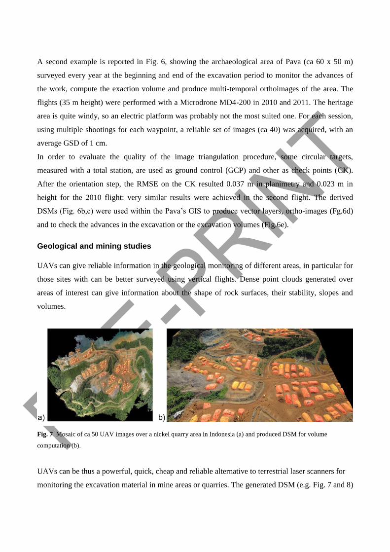
Geological and mining studies
UAVs can give reliable information in the geological monitoring of different areas, in particular for
those sites with can be better surveyed using vertical flights. Dense point clouds generated over
areas of interest can give information about the shape of rock surfaces, their stability, slopes and
volumes.
Fig. 7 Mosaic of ca 50 UAV images over a nickel quarry area in Indonesia (a) and produced DSM for volume
computation (b).
UAVs can be thus a powerful, quick, cheap and reliable alternative to terrestrial laser scanners for
monitoring the excavation material in mine areas or quarries. The generated DSM (e.g. Fig. 7 and 8)

allows quick multi-temporal volumes estimations, without problems of occlusion that can be faced
by using terrestrial acquisitions.
Fig. 8 The flight plan for an UAV surveying of the rock quarry visualized in GoogleEarth (a). The image orientation
results, showing different strips composed of oblique and nadir images (b). Produced photogrammetric DSM for
excavation monitoring and volume computation (c).
Urban areas
An UAV platform can be used to survey small urban areas, when national regulation allows doing
it, for cartographic, mapping and cadastral applications. These images have very high resolution if
flights are performed at 100-200 m height over the ground. Very high overlaps are recommended in
order to reduce occluded areas and achieve more complete and detailed DSM. A sufficient number
of GCPs is mandatory in order to geo-reference the processed images within the bundle adjustment
and derive point clouds: the number of GCPs varies according to the image block dimensions and
the complexity of the surveyed area. The quality of achieved point clouds is usually very high (up to
few centimetres) and this data can thus be used for further analysis and feature extraction.
In Fig. 9, a dense urban area in Bandung (Indonesia) is shown: the area was surveyed with an
electric fixed-wing RPV platform at an average height of about 150 m. Due to weather conditions
(quite strong wing) and the absence of an auto-pilot onboard, the acquired images (ca 270, average
GSD is about 5 cm) are not perfectly aligned in strips (Fig.9b). After the bundle block adjustment, a
dense DSM was created for the estimation of the population in the surveyed area and map
production.

Fig. 9 A mosaic over an urban area in Bandung, Indonesia (a). Visualization of the bundle adjustment results (b) of the
large UAV block (ca 270 images) and a close view of the produced DSM over the urban area, shown as point cloud (c,
d) and shaded mode (e).
A second example is an UAV flight over the area of Povo (Trento, Italy). Images were acquired at
100-125 m height using a Microdrone MD4-200 with a Pentax Optio A40 camera (8 mm focal
length) onboard. The average GSD is about 3 cm and the degree of detail is very high over the
whole area. The image overlap was about 80% along track and 40% across track. The image block
(four parallel strips plus one higher and orthogonal) allowed the generation of a very detailed and
dense DSM (Fig. 10). The generated DSM was finally used for the building footprint extraction, the
cadastral updating of the area, photovoltaic potential computation or 3D building modeling.

Fig. 10 Visualization of the image triangulation results of the UAV block (a). A close view of the produced dense
point cloud of the urban area (b) and the derived 3D building models (LOD2) of the surveyed area (c).
Conclusions and future developments
The article presented an overview of existing UAV systems, problems and applications with
particular attention to the Geomatics field. The examples reported in the paper show the current
state-of-the-art of photogrammetric UAV technology in different application domains. Although
automation is not always demanded, the reported achievements demonstrate the high level of
autonomous photogrammetric processing. UAVs have recently received a lot of attention, since
they are fairly inexpensive platforms, with navigation/control devices and recording sensors for
quick digital data production. The great advantage of actual UAV systems is the ability to quickly
deliver high temporal and spatial resolution information and to allow a rapid response in a number
of critical situations where immediate access to 3D geo-information is crucial. Indeed they feature

real-time capability for fast data acquisition, transmission and, possibly, processing. UAVs can be
used in high risk situations and inaccessible areas although they still have some limitations in
particular for the payload, insurance and stability. Rotary wing UAV platforms can even take-off
and land vertically, thus no runway area is required, while fixed wing UAVs can cover wider areas
in few minutes. For some applications, not demanding very accurate 3D results, complete remote
sensing solutions, based on open hardware and software are also available. And in case of small
scale applications, UAVs can be a complement or replacement of terrestrial acquisition (images or
range data). The derived high-resolution images (GSD generally in the centimetre level) can be
used, beside very dense point cloud generation, for texture mapping purposes on existing 3D data,
for orthophoto production, map and drawing generation or 3D building modelling. If compared to
traditional airborne platforms, UAVs decrease the operational costs and reduce the risk of access in
harsh environments, still keeping high accuracy potential. But the small or medium format cameras
which are generally employed, in particular on low-cost and small payload systems, enforce the
acquisition of a higher number of images in order to achieve the same image coverage at a
comparable resolution. In these conditions, automated and reliable orientation software are strictly
recommended to reduce the processing time. Some reliable solution are nowadays available, even in
the low-cost open-source sector.
The stability of low-cost and light platforms is generally an important issue, in particular in windy
areas, although camera and platform stabilizers can reduce the weather dependency. Generally the
stability issue is solved shooting many images (continuous acquisition or multiple shots from the
predefined waypoints) and using, during the processing phase, only the best image. High altitude
surveying can affect gasoline and turbine engines while the payload limitation enforce the use of
low weight GNSS/IMU thus denying direct geo-referencing solutions. New reliable navigation
systems are nowadays available, but the cost has limited their use until now to very few examples.
A drawback is thus the system manoeuvre and transportation that generally requires at least two
persons.
Fig. 11 Approximate time effort in a typical UAV-based photogrammetric workflow.
UAV regulations are under development in several countries all around the world, in order to
propose some technical specifications and areas where these devices can be used (e.g. over urban
settlements), increasing the range of their applications. At the moment, the lack of precise rule
frameworks and the tedious requests for flight permissions, represent the biggest limitation for
UAV applications. Hopefully the incoming rules will regulate UAV applications for surveying
issues.
Considering an entire UAV-based field campaign (Fig. 11) and based on the authors’ experience,
we can safely say that, although automation has reached satisfactory level of performances for
automated tie point extraction and DSM generation, an high percentage of the time is absorbed by
the image orientation and GCPs measurements, in particular if direct geo-referencing cannot be
performed. The time requested for the feature extraction depends on the typology of feature to be
extracted and is generally a time-consuming phase too.
The GCPs measurement step represents an important issue with UAV image blocks. As the
accuracy of the topographic network is influencing the image triangulation accuracy and the GSD
of the images is often reaching the centimetre level, there might be problems in reaching sub-pixel
accuracies at the end of the image triangulation process. So far, in the literature, RMSEs of 2-3
pixels are normally reported, also due to the camera performances, image network quality, un-
modelled errors, etc.
In the near future, the most feasible improvement should be related to payload, autonomy and
stability issues as well as faster (or even real-time) data processing thanks to GPU programming
(Wendel et al., 2012). High-end navigation sensors, like DGPS and inexpensive INS would allow
direct geo-referencing with accurate results. In case of low-end navigation systems, real-time image
orientation could be achieved with onboard advanced SLAM (Simultaneous Localisation And

Mapping) methods (Konolige et al., 2008; Nuechter et al., 2007; Strasdat et al., 2010). Lab post-
processing will be most probably always mandatory for applications requiring high accuracy
results.
On the other hand, the acquisition of image blocks with a suitable geometry for photogrammetric
process is still a critical task, especially in case of large scale projects and non-flat objects (e.g.
buildings, towers, rock faces, etc.). While the planning of image acquisition is quite simple when
using nadir images, the same task becomes much more complex in the case of 3D objects requiring
convergent images.
Two or more flights can be necessary over large areas, when UAV with reduced endurance limits
are used, leading to images with illumination changes due to the different acquisition time that may
affect the DSM generation and orthoimage quality. Future research has also to be addressed to
develop tools for simplifying this task. Other hot research issues tied to UAV applications are
related to the use of new sensors on-board like thermal, multispectral (Bolten and Bareth, 2012) or
range imaging cameras (Lange et al., 2011), just to cite some of them.
Acknowledgements
The work was partly supported by the 3M and CIEM project (co-founded Marie-Curie Actions 7th
F.P. - PCOFOUND- GA-2008-226070, acronym “Trentino Project”). The authors are really
thankful to Zenit (http://www.zenit-sa.com), Dr Deni Suwardhi (ITB Bandung, Indonesia), Dr Catur
Aries Rokhmana (Gadjah Mada University, Indonesia) and Prof. Juan José Fernández Martin
(Valladolid University, Spain) for providing some datasets presented in the article and useful
discussions on the UAV topic.
References
http://www.uvs-international.org/ (last accessed: December, 2012).
Sanna A, Pralio B (2005) Simulation and control of mini UAVs. Proc. 5th WSEAS Int. Conference on Simulation,
Modelling and Optimization, 135-141.
Von Blyenburg P (1999) UAVs-Current Situation and Considerations for the Way Forward. RTO-AVT Course on
Development and Operation of UAVs for Military and Civil Applications, 1999.
Colomina I, Blázquez M, Molina P, Parés M.E, Wis M (2008) Towards a new paradigm for high-resolution low-cost
photogrammetry and remote sensing. Int. Archives of Photogrammetry, Remote Sensing and Spatial Information
Sciences, Beijing, China, 37 (B1): 1201-1206.
Eisenbeiss H (2009) UAV photogrammetry. Dissertation ETH No. 18515, Institute of Geodesy and Photogrammetry,
ETH Zurich, Switzerland, Mitteilungen 105.

Bendea H, Boccardo P, Dequal S, Giulio Tonolo F, Marenchino D, Piras M (2008) Low cost UAV for post-disaster
assessment. Int. Archives of Photogrammetry, Remote Sensing and Spatial Information Sciences, Beijing, China, 37
(B1): 1373-1379.
Grenzdörffer G J, Engel A, Teichert B (2008) The photogrammetric potential of low-cost UAVs in forestry and
agriculture. Int. Archives of Photogrammetry, Remote Sensing and Spatial Information Sciences, Beijing, China, 2008
37(B1): 1207-1213.
Meier L, Tanskanen P, Fraundorfer F, Pollefeys M (2011) The PIXHAWK open-source computer vision framework for
MAVS. Int. Archives of Photogrammetry, Remote Sensing and Spatial Information Sciences, Zurich, Switzerland, 38
(1/C22).
http://ec.europa.eu/enterprise/sectors/aerospace/uas/ (accessed on July 2013).
Neitzel F, Klonowski J (2011). Mobile 3D mapping with low-cost UAV system. Int. Archives of Photogrammetry,
Remote Sensing and Spatial Information Sciences, Zurich, Switzerland, 38 (1/C22).
Niethammer U, Rothmund S, Schwaderer U, Zeman J, Joswig M (2011) Open source image-processing tools for low-
cost UAV-based landslide investigation. In: Int. Archives of Photogrammetry, Remote Sensing and Spatial Information
Sciences, Zurich, Switzerland, 38 (1/C22).
Stempfhuber W, Buchholz M (2011) A precise, low-cost RTK GNSS system for UAV applications. Int. Archives of
Photogrammetry, Remote Sensing and Spatial Information Sciences, Zurich, Switzerland, 38 (1/C22).
Vallet J, Panissod F, Strecha C, Tracol M (2011) Photogrammetric performance of an ultra-light weight Swinglet UAV.
Int. Archives of Photogrammetry, Remote Sensing and Spatial Information Sciences, Zurich, Switzerland, 38 (1/C22).
Nagai M, Shibasaki R, Manandhar D, Zhao H (2004) Development of digital surface and feature extraction by
integrating laser scanner and CCD sensor with IMU. Int. Archives of Photogrammetry, Remote Sensing and Spatial
Information Science, Istanbul, Turkey, 35(B5).
Vierling L A, Fersdahl M, Chen X, Li Z, Zimmerman P (2006) The Short Wave Aerostat-Mounted Imager (SWAMI):
A novel platform for acquiring remotely sensed data from a tethered balloon. Remote Sensing of Environment 103:
255-264.
Wang W Q, Peng Q C, Cai J Y (2009) Waveform-diversity-based millimeter-wave UAV SAR remote sensing.
Transactions on Geoscience and Remote Sensing 47(3): 691-700.
Berni J A J, Zarco-Tejada P J, Suárez L, González-Dugo V, Fereres E (2009) Remote sensing of vegetation from UAV
platforms using lightweight multispectral and thermal imaging sensors. Int. Archives of Photogrammetry, Remote
Sensing and Spatial Information Sciences, Hannover, Germany, 38 (1-4-7/W5).
Kohoutek T K, Eisenbeiss H (2012) Processing of UAV basedrange imaging data to generate detailed elevation models
of complex natural structures. Int. Archives of Photogrammetry, Remote Sensing and Spatial Information Sciences,
Melbourne, Australia, 39(1).
Grenzdoffer G, Niemeyer F, Schmidt F (2012) Development of four vision camera system for micro-UAV. Int.
Archives of Photogrammetry, Remote Sensing and Spatial Information Sciences, Melbourne, Australia, 2012, 39(1).
Huckridge D A, Ebert R R (2008) Miniature imaging devices for airborne platforms. Proc. SPIE, Vol. 7113, 71130M,
http://dx.doi.org/10.1117/12.799635
Schafroth D, Bouabdallah S, Bermes C, Siegwart R (2009) From the test benches to the first prototype of the muFly
micro helicopter. Journal of Intelligent and Robotic Systems, 54(1-3): 245-260.
Franceschini N, Ruffier F, Serres J (2007) A bio-inspired flying robot sheds light on insect piloting abilities. Current
Biology, 17(4): 329-335.
Moore R J D, Thurrowgood S, Soccol D, Bland D, Srinivasan M V (2007) A bio-inspired stereo vision system for
guidance of autonomous aircraft. Proc. Int. Symposium on Flying Insects and Robots, Ascona, Switzerland.
Niranjan S, Gupta G, Sharma N, Mangal M, Singh V (2007) Initial efforts toward mission-specific imaging surveys
from aerial exploring platforms: UAV. In: Map World Forum, Hyderabad, India, 2007; on CD-ROM.
Everaerts J (2008) The Use of Unmanned Aerial Vehicles (UAVS) for Remote Sensing and Mapping. In: Int. Archives
of Photogrammetry, Remote Sensing and Spatial Information Sciences, Beijing, China, 37 (B1):1187-1192.
Newcombe L (2007) Green fingered UAVs. Unmanned Vehicle, .
Martinez J R, Merino L, Caballero F, Ollero A, Viegas D X (2006) Experimental results of automatic fire detection and
monitoring with UAVs. Forest Ecology and Management, 234S (2006) S232.
Réstas A (2006) The regulation Unmanned Aerial Vehicle of the Szendro Fire Department supporting fighting against
forest fires 1st in the world! Forest Ecology and Management, 234S.
Berni J A J, Zarco-Tejada P J, Suárez L, Fereres E (2009) Thermal and Narrowband Multispectral Remote Sensing for
Vegetation Monitoring From an Unmanned Aerial Vehicle. Transactions on Geoscience and Remote Sensing, 47: 722-
738
Çabuk A, Deveci A, Ergincan F (2007) Improving heritage documentation. GIM International, 21 (9).
Lambers K, Eisenbeiss H, Sauerbier M, Kupferschmidt D, Gaisecker Th, Sotoodeh S, Hanusch Th (2007) Combining
photogrammetry and laser scanning for the recording and modelling of the late intermediate period site of Pinchango
Alto, Palpa, Peru. Journal of Archaeological Science 34 (10):1702-1712.
Oczipka M, Bemman J, Piezonka H, Munkabayar J, Ahrens B, Achtelik, M. and Lehmann, F. (2009) Small drones for
geo-archaeology in the steppes: locating and documenting the archaeological heritage of the Orkhon Valley in
Mongolia. Remote Sensing for Environmental Monitoring, GIS Applications and Geology 7874: 787406–1.
Verhoeven G J J (2009) Providing an archaeological bird’s-eye view – an overall picture of Ground – based means to
execute low-altitude aerial photography (LAAP) in Archaeology. Archaeological Prospection, 16: 233-249, DOI
10.1002/arp.354.
Chiabrando F, Nex F, Piatti D, Rinaudo F (2011) UAV And RPV Systems For Photogrammetric Surveys In
Archaelogical Areas: Two Tests In The Piedmont Region (ITALY). Journal of Archaeological Science, 38: 697 - 710,
ISSN: 0305-4403, DOI: 10.1016/j.jas. 2010.10.022
Rinaudo F, Chiabrando F, Lingua A, Spanò A (2012) Archaeological site monitoring: UAV photogrammetry could be
an answer. Int. Archives of Photogrammetry, Remote Sensing and Spatial Information Sciences, Melbourne, Australia,
39(5).
Thamm H P, Judex M (2006) The “Low cost drone” – An interesting tool for process monitoring in a high spatial and
temporal resolution. Int. Archives of Photogrammetry, Remote Sensing and Spatial Information Sciences, Enschede,
The Netherlands, 36 (7).
Niethammer U, Rothmund S, James M R, Traveletti J, Joswig M (2010) UAV-based remote sensing of landslides. Int.
Archives of Photogrammetry, Remote Sensing and Spatial Information Sciences, Newcastle upon Tyne, UK, 38 (5), on
CD-ROM.
Zhang C (2008) An UAV-based photogrammetric mapping system for road condition assessment. In: International
Archives of Photogrammetry, Remote Sensing and Spatial Information Science, Beijing, China, 37.
Manyoky M, Theiler P, Steudler D, Eisenbeiss H (2011) Unmanned aerial vehicle in cadastral applications. Int.
Archives of Photogrammetry, Remote Sensing and Spatial Information Sciences, Zurich, Switzerland, 38 (1/C22).

Hartmann W, Tilch H S, Eisenbeiss H, Schindler K (2012) Determination of the UAV position by automatic processing
of thermal images. Int. Archives of Photogrammetry, Remote Sensing and Spatial Information Sciences, Melbourne,
Australia, 39 (5).
Smith J G, Dehn J, Hoblitt R P, LaHusen R G, Lowenstern J B, Moran S C, McClelland L, McGee K A, Nathenson M,
Okubo P G, Pallister J S, Poland M P, Power J A, Schneider D J, Sisson T W (2009) Volcano monitoring. Geological
Monitoring, Geological Society of America, Eds Young and Norby, 273–305, doi: 10.1130/2009.
Chou T-Y, Yeh M-L, Chen Y C, Chen Y H (2010) Disaster monitoring and management by the unmanned aerial
vehicle technology. Int. Archives of Photogrammetry, Remote Sensing and Spatial Information Sciences, Vienna,
Austria, 38(7B):137-142.
Haarbrink R B, Koers E (2006) Helicopter UAV for Photogrammetry and Rapid Response. Int. Archives of
Photogrammetry, Remote Sensing and Spatial Information Sciences, Antwerp, Belgium, 36 (1/W44).
Molina P, Colomina I, Vitoria T, Silva P F, Skaloud J, Kornus W, Prades R, Aguilera C (2012) Searching lost people
with UAVs: the system and results of the close-search project. Int. Archives of Photogrammetry, Remote Sensing and
Spatial Information Sciences, Melbourne, Australia, 39(1).
Puri A, Valavanis P, Kontitsis M (2007) Statistical profile generation for traffic monitoring using real-time UAV based
video data. Mediterranean Conference on Control & Automation, Athens, Greece, on CD-ROM
Pueschel H, Sauerbier M, Eisenbeiss H (2008) A 3D model of Castle Landemberg (CH) from combined
photogrammetric processing of terrestrial and UAV-based images. Int. Archives of Photogrammetry, Remote Sensing
and Spatial Information Sciences, Beijing, China, 37 (B6): 96-98.
Remondino F, Gruen A, Von Schwerin J, Eisenbeiss H, Rizzi A, Sauerbier M, Richards-Rissetto, H (2009) Multi-
sensors 3D documentation of the Maya site of Copan. Proc. of 22nd CIPA Symposium, Kyoto, Japan, on CD-ROM.
Przybilla H-J, Wester-Ebbinghaus W (1979) Bildflug mit ferngelenktem Kleinflugzeug. Bildmessung und
Luftbildwesen. Zeitschrift fuer Photogrammetrie und Fernerkundung. Herbert Wichman Verlag, Karlsruhe, Germany.
De Agostino M, Manzino A M, Piras M (2010) Performances comparison of different MEMS-based IMUs. Record -
IEEE PLANS, Position Location and Navigation Symposium , art. no. 5507128: 187-201.
Piras M, Marucco G, Charqane K (2010) Statistical analysis of different low cost GPS receivers for indoor and outdoor
positioning. Record - IEEE PLANS, Position Location and Navigation Symposium , art. no. 5507325: 838-849.
Remondino F, Fraser C (2006) Digital cameras calibration methods: considerations and comparisons. Int. Archives of
Photogrammetry, Remote Sensing and Spatial Information Sciences, 36(5): 266-272.
Colomina I, Aigner E, Agea A, Pereira M, Vitoria T, Jarauta R, Pascual J, Ventura J, Sastre J Brechbühler de Pinho G,
Derani A, Hasegawa J (2007) The uVISION project for helicopter-UAV photogrammetry and remote-sensing. Proc. of
the 7th International Geomatic Week, Barcelona, Spain.
Brown D C (1976) The bundle adjustment - progress and prospects. In: International Archives of Photogrammetry, 21
(3).
Triggs W, McLauchlan P, Hartley R, Fitzgibbon A (2000) Bundle adjustment – A modern synthesis. Eds W. Triggs, A.
Zisserman, and R Szeliski Vision Algorithms: Theory and Practice, LNCS, Springer Verlag, pp. 298-375.
Gruen A, Beyer H A (2001) System calibration through self-calibration. Calibration and Orientation of Cameras in
Computer Vision, Gruen and Huang (Eds.), Springer Series in Information Sciences, 34: 163-194.
Barazzetti L, Scaioni M, Remondino F (2011) Orientation and 3D modeling from markerless terrestrial images:
combining accuracy with automation. The Photogrammetric Record, 25 (132): 356–381.
Pierrot-Deseilligny M, Clery I (2011) APERO, An Open Source Bundle Adjustment Software for Automatic
Calibration and Orientation of Set of Images. Int. Archives of Photogrammetry, Remote Sensing and Spatia Information
Sciences, 38 (5/W16), Trento, Italy, on CD-ROM.
Hartley R, Zisserman A (2004) Multiple View Geometry in Computer Vision. Cambridge University Press.
Snavely N, Seitz S M, Szeliski R (2008) Modeling the world from Internet photo collections. Int. Journal of Computer
Vision, 80 (2): 189-210.
Robertson D P, Cipolla R (2009) Structure from Motion. Practical Image Processing and Computer Vision, John Wiley,
Varga, M. (eds.).
Wu C (2011) VisualSFM: A Visual Structure from Motion System, http://www.cs.washington.edu/homes/ccwu/vsfm/
Snavely S, Seitz S M, Szeliski R (2007) Modeling the World from Internet Photo Collections. International Journal of
Computer Vision, 2(80): 189-210
Pfeifer N, Glira P, Briese C (2012) Direct georeferencing with on board navigation components of light weight UAV
platforms. Int. Archives of Photogrammetry, Remote Sensing and Spatial Information Sciences, Melbourne, Australia,
39(7).
Zhou G (2009) Near real-time orthorectification and mosaic of small UAV video flow for time-critical event response.
IEEE Trans. Geoscience and Remote Sensing, 47(3): 739-747.
Eugster H, Nebiker S (2008) UAV-based augmented monitoring– real-time georeferencing and integration of video
imagery with virtual globes. Int. Archives of Photogrammetry, Remote Sensing and Spatial Information Sciences,
Beijing, China, 37 (B1): 1229-1235.
Wang J, Garratt M, Lambert A, Wang J J, Han S, Sinclair D (2008) Integration of GPS/INS/vision sensors to navigate
unmanned aerial vehicles. Int. Archives of Photogrammetry, Remote Sensing and Spatial Information Sciences, Beijing,
China, 37 (B1): 963-969.
Barazzetti L, Remondino F, Scaioni M (2010) Fully automated UAV image-based sensor orientation. Int. Archives of
Photogrammetry, Remote Sensing and Spatial Information Sciences, Calgary, Canada, 38 (1), on CD-ROM.
Anai T, Sasaki T, Osaragi K, Yamada M, Otomo F, Otani H (2012) Automatic exterior orientation procedure for low-
cost UAV photogrammetry using video image tracking technique and GPS information. Int. Archives of
Photogrammetry, Remote Sensing and Spatial Information Sciences, Melbourne, Australia, 39(7).
Granshaw S I (1980) Bundle adjustment method in engineering photogrammetry. Photogrammetric Record, 10 (56):
111-126.
Dermanis A (1994) The photogrammetric inner constraints. ISPRS Journal of Photogrammetry and Remote Sensing, 49
(1): 25-39
Seitz S, Curless B, Diebel J, Scharstein D, Szeliski R (2006) A comparison and evaluation of multi-view stereo
reconstruction algorithms. Proc. IEEE Conf. CVPR’06, New York, 17-22 June 2006, 1:519-528.
Vu H, Keriven R, Labatut P, Pons J-P (2009) Towards high-resolution large-scale multi-view stereo. Proc. IEEE Conf.
CVPR’09, 1430-1437.
Zhu Q, Zhang Y, Wu B, Zhang Y (2010) Multiple close-range image matching based on self-adaptive triangle
constraint. The Photogrammetric Record, 25 (132): 437-453.
Gerke S, Morin K, Downey M, Boehrer N, Fuchs T (2010) Semi-global matching: an alternative to LiDAR for DSM
generation? Int. Archives of Photogrammetry, Remote Sensing and Spatial Information Sciences, Calgary, Canada, 38
(1), on CD-ROM.

Hirschmüller H (2008) Stereo processing by Semi-Global Matching and Mutual Information. IEEE Transactions on
Pattern Analysis and Machine Intelligence, 30 (2): 328–341.
Furukawa Y, Ponce J (2010) Accurate, dense and robust multiview stereopsis. IEEE Transactions on Pattern Analysis
and Machine Intelligence (PAMI), 32 (8): 1362-1376.
Pierrot-Deseilligny M, Paparoditis N (2006) A multiresolution and optimization-based image matching approach: an
application to surface reconstruction from SPOT5-HRS stereo imagery. Int. Archives of Photogrammetry, Remote
Sensing and Spatial Information Sciences, Antalya, Turkey, 36 (1/W41), on CD-ROM.
Fiorillo F, Jimenez Fernandez-Palacios B, Remondino F, Barba S, 2012. 3D Surveying and modeling of the
archaeological area of Paestum, Italy. Proc. 3rd Inter. Conference Arquelogica 2.0, 2012, Sevilla, Spain.
Remondino F, Barazzetti L, Nex F, Scaioni M, Sarazzi D (2011) UAV photogrammetry for mapping and 3D modeling -
Current status and future perspectives. In: Int. Archives of Photogrammetry, Remote Sensing and Spatial Information
Sciences, 38(1/C22). ISPRS Conference UAV-g, Zurich, Switzerland.
Wendel A, Maurer M, Graber G, Pock T, Bischof H (2012) Dense reconstruction on-the-fly. Proc. IEEE Int. CVPR
Conference, Providence, USA.
Konolige K, Agrawal M (2008) Frameslam: from bundle adjustment to realtime visual mapping. IEEE Journal of
Robotics and Automation, 24 (5):1066–1077.
Nuechter A, Lingemann K, Hertzberg J, Surmann H (2007) 6D SLAM for 3D mapping outdoor environments. Journal
of Field Robotics (JFR), Special Issue on Quantitative Performance Evaluation of Robotic and Intelligent Systems, 24
(8-9): 699-722.
Strasdat H, Montiel J M M, Davison A J (2010) Scale drift-aware large scale monocular SLAM. Robotics: Science and
Systems.
Bolten A, Bareth G (2012) Introducing a low-cost Mini-UAV for Thermal- and Multispectral-Imaging. In: Int. Archives
of Photogrammetry, Remote Sensing and Spatial Information Sciences, Melbourne (Australia), 39(1).
Lange S, Sünderhauf N, Neubert P, Drews S, Protzel P (2011) Autonomous corridor flight of a UAV using a low-cost
and light-weight RGB-D camera. In: Advances in Autonomous Mini Robots, Proc. 6th AMiRE Symposium, 183-192,
ISBN 978-3-642-27481-7.