uce nabjnral hi§tory o~ if nova scotia ihiemie
TRANSCRIPT
Uce NabJnral Hi§tory o~ iF NOVA SCOTIA 1&
V 0 L U ME • T W 0
IHIEMIE ~GIONS

-~ ~
~
~
~ ~
~
~
fF'
F' F'
~
~ e ~
~
~ F ~
~
~
r'
~ ~
~
~
~
~ F ~
~
~
r'
~ F ~
F'
~
~
F ~
~ F
Natural History 9f . Nova Scotia·

. . . . . . . . . . . . . . . . . . . . . . . . . . .
©Crown copyright, Province of Nova Scotia, 1996. 97 98 99 00 0 l 02 03 7 6 5 4 3 2 1
Produced by the Nova Scotia Museum, the Department of Education and Culture, Province of Nova Scotia. Minister: Honourable Robbie Harrison Deputy Minister: Lloyd Gillis
The first edition ofThe Natural History of Nova Scotia was written by Michael Simmons, Derek Davis, Lesley Griffiths and Ann Muecke and published in 1984 as a joint project by the Department of Lands and Forests (now the Department of Natural Resources) and the Nova Scotia Museum. The first edition was reprinted in 1989.
This revised edition is based extensively on the first edition and was produced by the Nova Scotia Museum in partnership with Communications Nova Scotia and with the financial assistance of the Canada/ NovaScotia Cooperation Agreement on Sustainable Economic Development.
Editors:
Graphic Designer: Production: Scans:
~ NOVA\SCOTIA
Department of Educmion and Culture
Derek S. Davis Sue Browne David MacDonald Derek Cowie Design Image House Digital
Co-published with Nimbus Publishing. A product of the Nova Scotia Government Co-publishing Program.
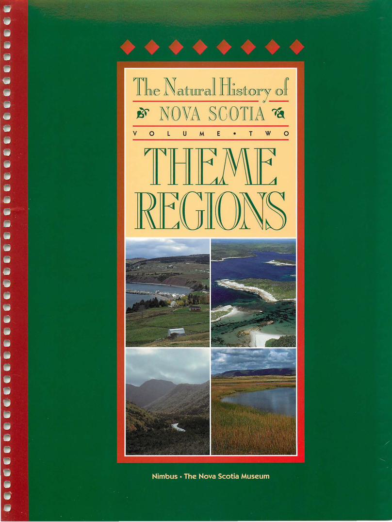
Cover photographs: Ballantynes Cove, Antigonish Co.:
............... . ..........
Roger Lloyd; Dover Island beach near Canso, Guysborough Co.: Oliver Maass; Cape Breton Highlands: Alex Wilson; Cheticamp Causeway, Inverness Co.: Alex Wilson.
Canadian Cataloguing in Publication Data Main entry under title:
The natural history o f Nova Scotia
Rev. ed. Co-published by the Nova Scotia Museum. Includes index. Contents: V. l. Topics and habitats- v. 2. Theme regions. ISBN 1-55109-236-0 (v.l) ISBN l-55109-238-7 (v.2)
1. Natural history- Nova Scotia. I. Davis, Derek S. II. Browne, Sue. III. Nova Scotia Museum.
QH106.2.N68N27 1997 508.716 C95-966009-7
-~
~
~
~ ~ ~
F
~
F
F
~ ~
~ ~ ~ ~
~ ~ F'
~
~ F ~
~
~ ~
~ ~
~
~
·~
F'
e ~
.............................................................. PAGE
iii .. TABLE OF CONTENTS
Acknowledgements ........................................................................................................ vi Introduction ................................................................................................................. viii
THEME REGIONS page 100 Plateau-Taiga .......................................................................................................... 3
200 Highlands ................................................................................................................ 9 210 Plateau-Fir Forest .......................................................................................... 14 220 Steep Slopes ................................................................................................... 17
300 Avalon Uplands ..................................................................................................... 21 310 Hardwood Plateau ......................................................................................... 25
311 Cobequid Hills ....................................................................................... 26 312 Pictou-Antigonish Highlands ............................................................... 30 313 North Bras d'Or Uplands ...................................................................... 33 314 Mabou Highlands ................................................................................. 36
320 Dissected Margins ......................................................................................... 38 330 Fault R~dges .................................................................................................... 40
400 Atlantic Interior .................................................................................................... 43 410 Quartzite Plains .............................................................................................. 50
411 Southwest Schists .................................................................................. 51 412 Mersey Meadows .................................................................................. 53 413 Quartzite Barrens .................................................................................. 56
420 Slopes and Ridges .......................................................................................... 59 421 Sissiboo Lowlands ................................................................................. 60 422 South Mountain Slope .......................................................................... 62 423 Slate Ridges ............................................................................................ 64
430 Drumlins ......................................................................................................... 66 431 Annapolis Drumlins .............................................................................. 68 432 Ponhook Drumlins ................................................................................ 69 433 Kejimkujik Drumlins ............................................................................. 70 434 Lunenburg Drumlins ............................................................................ 72 435 Eastern Shore Drumlins ....................................................................... 7 4 436 Headwater Lakes ................................................................................... 76
440 Granite Barrens .............................................................................................. 77 450 Granite ............................................................................................................ 80
451 Granite Uplands .................................................................................... 81 452 Shelburne Granite Plain ....................................................................... 84 453 Granite Ridge ......................................................................................... 86
460 Bays ................................................................................................................. 88
Theme Regions: Natural History of Nova Scotia, Volume II

PAGE
iv ..............................................................
TABLE OF
CONTENTS
continued
THEME REGIONS page 500 Carboniferous Lowlands ...................................................................................... 93
510 Till Plain .......................................................................................................... 99 511 Windsor Lowlands .............................................................................. 100 512 Salmon River Lowland ........................................................................ 106
520 Coastal Plain ....................................... : ......................................................... 107 521 Northumberland Plain ....................................................................... 108 522 Judique Coastal Lowland .................................................................... 112 523 Tantramar Marshes ............................................................................ 113
530 Stony and Wet Plain ..................................................................................... 116 531 Sydney Coalfield .................................................................................. 117 532 Chignecto Plains ................................................................................. 120
540 Clay Plain ...................................................................................................... 123
550 Coastal Fringe ·····················································~········································ 124 551 Inverness Coastal Plain ....................................................................... 125 552 Victoria Coastal Plain .......................................................................... 127
560 Submerged Lowland .................................................................................... 129 570 Rolling Upland ............................................................................................. 131
571 Mulgrave Plateau ................................................................................ 132 572 St. Marys Fault Block .......................................................................... 134
580 Hills and Valleys ........................................................................................... 137 581 Cumberland Hills ................................................................................ 138 582 Pictou Valleys ...................................................................................... 140 583 Antigonish Uplands ............................................................................ 142 584 Ainslie Uplands ................................................................................... 144 585 Iona Uplands ....................................................................................... 146
590 Dissected Plateau ......................................................................................... 148 591 Margaree Plateau ................................................................................ 149 592 St. Lawrence Slopes ............................................................................ 152
600 Triassic Lowlands ................................................... : ........................................... 155 610 Valley ............................................................................................................. 159 620 Tidal Bay ....................................................................................................... 164
700 Fundy Coast ......................................................................................................... 169 710 Basalt Headlands ...................................... .-.................................................. 172 720 Basalt Ridge .................................................................................................. 176
800 Atlantic Coast ...................................................................................................... 181 810 Basalt Peninsula ........................................................................................... 187 820 Cliffs and Beaches ........................................................................................ 189 830 Beaches and Islands .................................................................................... 192
831 Tusket Islands ...................................................................................... 194 832 LaHave Drumlins ................................................................................ 196 833 Eastern Shore Beaches ....................................................................... 198 834 Bayoflslands ....................................................................................... 201
840 Quartzite Headlands .................................................................................... 203 841 Capes and Bays ................................................................................... 204 842 Guys borough Harbours ...................................................................... 207
850 Granite Barrens ............................................................................................ 209 851 Pennant Barrens .................................................................................. 210 852 Canso Barrens ..................................................................................... 213
Natural History of Nova Scotia, Volume II: Theme Regions
~
~
~
~
~
~
~
~
~
~
~
~
~
~
~
.............................................................. PAGE
v • THEME REGIONS page
860 Sedimentary Lowland .................................................................................. 216 870 Till Plain ........................................................................................................ 219 880 Cliffed Island ................................................................................................ 222 890 Sandy Island ................................................................................................. 223
900 Offshore/Continental Shelf ............................................................................... 227 910 Inner Shelf .................................................................................................... 232
911 Atlantic ................................................................................................. 235 912 Outer Bay of Fundy ............................................................................. 237 913 Inner Bay of Fundy .............................................................................. 239 914 Northumberland Strait ....................................................................... 241 915 Sydney Bight ........................................................................................ 244 916 Bras d'Or Lake ..................................................................................... 246
920 Middle Shelf ................................................................................................. 248 921 Banks .................................................................................................... 251 922 Basins ................................................................................................... 253 923 Valleys and Plains ................................................................................ 255
930 Outer Shelf .................................................................................................... 256 931 Outer Shelf Banks ................................................................................ 258 932 Bank Edges, Saddles, and Channels .................................................. 261
940 Scotian Slope ................................................................................................ 263
GLOSSARY .................................................................................................................... 267 INDEX ............................................................................................................................ 291 LIST OF ILLUSTRATIONS ............................................................................................... 303
Theme Regions: Natural History of Nova Scotia, Volume II

PAGE
vi
ACKNOWLEDGEMENTS
This revision of the Natural I-!istoty of Nova Scotia was made possible through the perseverence and vision of Dr. Derek S. Davis, until recently Chief Curator of Natural History at tl1e Nova Scotia Museum.
The project was built on the work of hundreds of people who have worked and are working in Nova Scotia. In an attempt to syntllesize the work, we have particularly relied on the expertise of a number of people in tile civil service and tl1e academic community as well as fi eld natural ists. Some of these people have reviewed drafts of tile manuscript, but tl1e final decisions are tllose of the project team. We wish to acknowledge witl1 deep gratitude tile contributions of those people listed below, but we do not hold them responsible for any errors or omissions. We apologize if we have missed anyone who contribu ted to tile project.
The project was funded under the CanadianNova Scotia Agreement on Sustainable Economic Development and was based at tl1e Nova Scotia Museum of Natural History.
Natural History of Nova Scotia, Volume II: Theme Regions
The following people helped produce tllis revised edition of the Natural J-!ist01y of Nova Scotia:
VOLUMES I AND II PROJECT TEAM:
PROJECT COORDINATOR
Sue Browne
PROJECT ADMINISTRATOR
Derek Davis
DATA MANAGEH
Maria Hartery
GHAPHI.C DESIGN
David MacDonald
HESEARGHEHS
Ron Loucks, Loucks Oceanology Ltd. Bernie McGuire Heather MacLeod Pat Stewart, Envirosphere Consultants Ltd.
TECHNICAL EDITING
Sue Browne Derek Davis
COPY EDITING
Douglas Beall Iris Coupe Peter King
Susan Lucy
Susan Lucy
Nicole Watkins Campbell Rebecca Fleming Robbie Rudnicki
OIIIGINAL ILLUSTHATIONS
Derek Davis Barry Donovan Barbara Lock Clinton Milligan
MAP
Gary Patterson Robert Raeside
Fred Scott Jeffrey Ward
Nova Scotia Geomarics Centre Tod Burt Lee MacNeill Gordon Cranton
SUPPORT DESIGN
Neil Meister
PHODUCrJON ART
Kevin Sallows
Derek Cowie Design Sherry Laidlaw
PHODUCI'ION MANAGEH
John Hennigar-Shuh
PHOTOGRAPHS FllOM THE COLLECTIONS OF:
Phyllis Blades, Bob Bancroft, Karen Casselman, Alan Dauphinee, Mark Elderkin, Carl Haycock, Oliver Maass, Linda Morris, Tim Randall, Nova Scotia
Department of Education and Culture, Nova Scotia Department of Natural Resources, and the Bedford Ins titute of Oceanography (BIO) .

THE FOLLOWING PROVINCIAL AGENCIES CONTRIBUTED TO THE REVISION:
Department of Agriculture and Marketing-with special thanks to Ken Beesley, Rob Gordon, Mike Langlands, Phil Warman, Ken Webb
Department ofEducation and Culture-with special thanks to Penny Brown, Angeline Doucet, John Gilhen, Bob Grantham, Debra McNabb, Scott Robson, Fred Scott, Sheila Stevenson, Alex Wilson, Ruth Whitehead, Barry Wright, John Hennigar-Shuh
Department of the Environment-with special thanks to Dave Briggens, Andrew Cameron, Herb Doane, Darryl Taylor
Department ofFisheries-with special thanks to Bob Bancroft, Kim Kelsey, Don MacLean
Department of Municipal Affairs-with special thanks to Brian Cuthbertson
Department of Natural Resources-with special thanks to Sandy Anderson, Dan Banks, Bob Boehner, Fred Boner, Colleen Brothers, John Calder, Howard Donahoe, Tony Duke, John Gillis, Ross Hall, Andrew Hanam, Paul Harvey, Dave Harris, David Hopper, Chris Kavanaugh, Duncan Keppie, John Leduc, Art Lynds, Jack MacDonald, Randy Milton, Peter Neiley, Tony Nette, Mike O'Brien, Garth Prime, Mark Pulsifer, Peter Rogers, Barry Sa bean, Dale Smith, Ken Snow, Ralph Stea, Chris Trider, Paul Tufts
Department of Supply and Services-with special thanks to Susan Lucy and Nicole Watkins Campbell
THE FOLLOWING FEDERAL AGENCIES CONTRIBUTED TO THE REVISION:
Atlantic Geoscience Centre-with special thanks to Gordon Fader, Don Forbes, Peter Giles, Gary Grant, Lubomir Jansa, Bob Miller, David Piper, Bob Taylor, John Wade
Canada/Nova Scotia Offshore Petroleum Boardwith special thanks to Dave Brown
Canadian Wildlife Service-with special thanks to Diane Amirault, Dick Brown, Tony Erskine, Steffan Gerriets, Peter Hicklin, Joe Kerekes, Tony Lock, AI Smith
Department of Agriculture-with special thanks to Gary Patterson
Department of Canadian Heritage-with special thanks to James Bridgeland, David Lawley, Neil Munro, Judith Tulloch
Department of National Defense-with special thanks to Wayne Lumpsdon
Department of Fisheries and Oceans-with special thanks to Don Gordon, Barry Hargrave, Brian Petrie, Gerald Seibert, Wes White
Environment Canada-with special thanks to Don Ambler, Tom Clair, John Dublin, Colleen Farrell
National Resource Council of Canada-with special thanks to Carolyn Bird
THE FOLLOWING ACADEMIC INSTITUTIONS CONTRIBUTED TO THE PROJECT:
Acadia University-with special thanks to Graham Daborn, Mike Dodswell, Sherman Bleakney, Tom Herman, Redge Newell, Ruth Newell, Bob Raeside
Dalhousie University-with special thanks to Barry Clark, Bill Friedman, Martin Giblin, Paul Schenk, Bob Scheibling, Dave Scott, Pierre Taschereau
Mount Allison University-with special thanks to Laing Ferguson
Nova Scotia College of Art and Design-with special thanks to Pat Manuel
St. Francis Xavier University-with special thanks to Tony Davis
Saint Mary's University-with special thanks to Terrence Day, Greg Klassen, Henrietta Mann, Hugh Millward, David Richardson, Doug Strongman, John Waldron
Technical University of Nova Scotia-with special thanks to Terry Hennigar
University College of Cape Breton-with special thanks to Don Arseneau, Charles Taylor
SPECIAL THANKS TO THE FOLLOWING INDIVIDUALS WHO CONTRIBUTED TO THE
PROJECT:
Peter Austin-Smith Norval Balch John Brett Paul-Michael Brunelle Karen Casselman Con Desplanques Arlene Diepenbrock Shauna Henderson David Hope-Simpson Robert Ireland Carole Jacquard Lewis King Alan Knockwood
Zoe Lucas MaryLynack Clinton Milligan Wallace Niven John Parsons Alan Ruffman Gary Saunders Ruth Smith Harry Thurston Mike Wamboldt Howard Williams Mary Williams
Theme Regions: Natural History of Nova Scotia, Volume II
PAGE
vii ..
PAGE
viii .. ..........................................................
INTRODUCTION
THE THEME REGIONS GEOGRAPHICAL CLASSIFICATION SYSTEM
Volume I of the NaturalHistoryofNovaScotia, Topics and Habitats, provides a description of the nonliving and living elements of the natural environment of the province. In Volume II, Theme Regions, the relationships between these elements are described as they actually occur in the landscape. This is achieved by use of a geographical classification system of Regions, Districts, and Units that are defined according to distinctive landscape characteristics. We hope the reader will be able to identify these Regions, Districts, and Units in the field, know when a boundary or transition zone has been crossed, and identify the distinctive environmental relationships that occur.
A map accompanies the description of each Region and shows its component Districts. Figures 1 and 2 are more detailed maps showing Units, and a larger folded 1:500,000 map is included in the back pocket of this volume. Boundaries are necessarily approximate and should be regarded as narrow zones rather than lines.
CLASSIFICATION SYSTEM
A hierarchical system has been developed to demonstrate how these geographical entities have been determined. This approach closely follows the Biophysical Land Classification System that has been widely applied to terrestrial areas since the mid-1960s. 1•2 It has been extended to include the marine areas adjacent to Nova Scotia.3
The three levels of the hierarchy are as follows: 1. Regions: eight on land and one in the sea 2. Districts: 33 on land and four in the sea 3. Units: 65 on land and 11 in the sea
In some cases Units are geographically dispersed and are coded with letters as sub-Units.
TERRESTRIAL THEME REGIONS
Nova Scotia has eight terrestrial Regions that have been divided into 33 Districts and 65 Units (see Figure 1).
Natural History of Nova Scotia, Volume II: Theme Regions
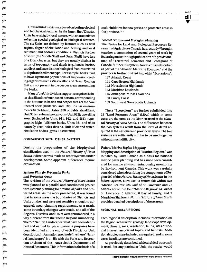
In the Biophysical Land Classification System, land regions are defined on the basis of "regional climate as expressed through regional vegetation." The classification adopted here recognizes six regional climates in Nova Scotia but further divides two of these climatic areas on the basis of regional geology to create eight Regions, as shown in Table 1.
The different Districts within a given Region are defined by ''a distinctive landscape pattern." This pattern may be a reflection of geology, surficial materials, soils, hydrology, relief, or vegetation. In each case, one dominant element has been selected as the defining characteristic; other elements are usually closely related. This definition ofDistricts corresponds closely to the definition of land districts adopted in the Biophyskal Land Classification System.
Units are generally fairly homogeneous areas within Districts. Landscapes may vary within them, but they reflect a recurring pattern of landforms, soils, or vegetation. Habitats can be identified and mapped within Units and used as a basis for detailed studies of species association and inventory (see Table 2}.
The following example is presented as an aid to the interpretation of the geographical divisions. Looking at the map, one finds:
313a This area known as the Creignish Hills is located northwest of Bras d'Or Lake on Cape Breton Island.
The number 313a stands for several things:
Theme Region 300 The first number, 3, refers to the Avalon Uplands (Region300}. These upland areas experience more severe winters, with greater amounts of precipitation and shorter growing seasons than the surrounding lowlands. Climatic conditions are not as harsh as in the Cape Breton highlands. This climate is reflected in the dominant hardwood vegetation characterized by a Sugar Maple, Yellow Birch-Fir association.
District 310 The second number, 1, refers to the distinctive geology and landforms found in District 310. This
~
~
~
~
~
~
~
~
~
~
~
~
~
~
~
~
~
~
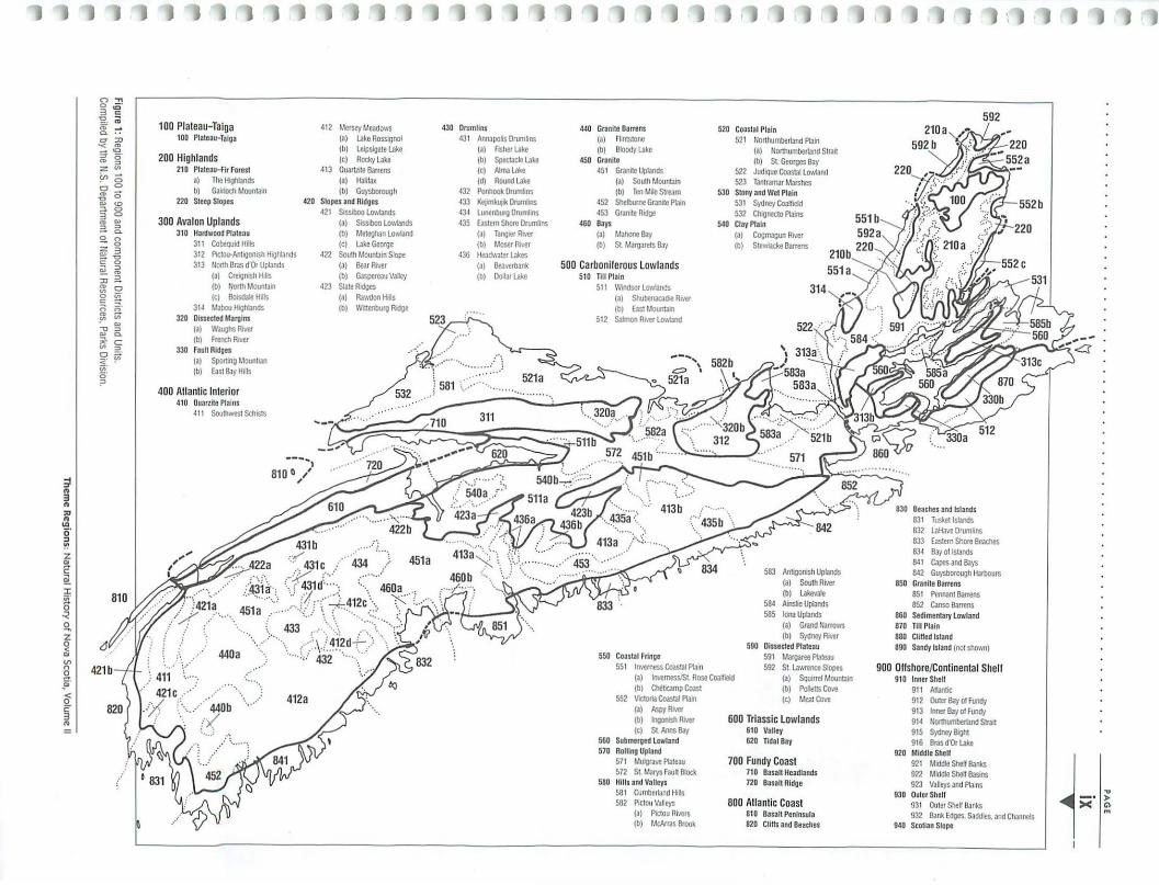
~ .. 3 .. "' .. "' c;· " !':' z "' c ~
100 Plateau-Taiga t OO Ptatea11-Tatga
200 Highlands 2t0 Plateau-fir Forest
a) The fl•ghbnds b) G>111och MounL11n
220 Steep Slopes
300 Avalon Uplands 3t0 Hanlwood Plateau
3tt CobeQuid Hilts 3t2 PK:tou·Ant~goniSit H~ghbnds
3t3 tJorth Bras d'Or Uplands (a) Cre~gniSit Hills (b) r.Jorth MounLlll1 (C) Bo!Sdale HjJs
3 I 4 ~Llbou H.ghtands 320 Dluected Margins
(a) Waughs R•'er (b) French RIY!f
330 Faull Ridges (a) Sport1ng Mounllan (b) East Bay H1lls
400 Atlantic Interior 4t0 Ouarzllo Plains
411 Southwest Sch~ts
4t2 Mersoy Meadows (a) uke Rossignol (b) LeiPSigate Uke (c) Rocky t..ke
413 QuartZite Barrens (a) Hat.tax (b) Guysbolough
420 Slopes and Ridges 42t SISSiboo Lowlands
(a) SISSiboo LO\•,iands (b) Mel!ghan LOYoiand (c) uke George
422 South Mounlam Slope (a) Bear Rrver (b) Gaspereau VaDey
423 State Ridges (a) Rawdon Hills (b) l 'l•ttenburg Ridge
.. ···· ·· ... ·· ..... ·· 412a
430 Drumlins 43t Annapolis Drumlins
(a) Fisher Uke (b) Spectlcte uke (c) Alma t..ke (d) nound t..ke
432 Penhook Drumlins 433 Ketlmkut•k Drumlins 434 Lunenburg Drumlins 435 Easte1n Shore Orumnns
(a) Tang~r RIVer (b) Moser Rrver
436 lteadwater Ukes (a) Beaverbank (b) Dollar Uke
440 Granite Barrens (a) Alntstone (b) Blocldyt..kc
450 Granite 45t Granite Uplands
(a) South MounL11n (b) TenM1IeSbeam
452 Shelburne Granite Plam 453 Gramte Rrdge
460 Bays (a) Mahone Bay (b) St Margarets Bay
500 Carboniferous Lowlands 5t0 n11 Plain
Stt Windsor Lo·,•,iands (a) Sllubenacad>e R,,., (b) East Mounlaln
512 Salmon Rrver LO'Ioiand
550 Coast.ll Fringe 551 Inverness Coastal Pb1n
520
530
540
Coastal Plain 521 Nonhumbertand PLlin
(a) Northumberland Strait (b) St Georges Bay
522 Jud1Que Coastal L01•iland 523 Tantramar Marshes Stony and Wet Plain 531 Sydney Coalfield 532 Ch'o)necto Plains Clay Plain (a) (b)
Cognugun Rrver Stevfiacke Barrens
583 Antigonish Uplands (a) SoulhRIVer (b) Lakevale
584 Arns6e Uplands 585 tonaUpbnds
(a) Grand llarrows (b) Sydlle'J Rrver
590 Dissected Plateau 591 Margaree PLll!au 592 St Lawrence Slopes
(a) tnverness/St Rose Coallleld (b) Cholbeamp Coast
(a) Squurel Mountarn (b) Pollens Cove
552 V.aona Coastal Plain (a) Aspy~"'
(b) lnoonrsh Rrver (c) SL Anns Bay
560 Submerged lowland 570 Rolling Upland
57 t Mutgrave PLlteau 572 St Marys Faull Block
5BO IIIIIs and Valleys 581 Cumbe1land fl1lls 582 Pictou Valleys
(a) Pictou Rrvers (b) lolcAtras Brook
(c) ll.eat COI'O
600 Triassic Lowlands 6t0 Valley 620 Tidal Bay
700 Fundy Coast 710 Basalt Headlands 720 Basalt Ridge
800 Atlantic Coast 810 Basal1 Peninsula 820 Cliftt and Beaches
Beaches and Islands 831 Tusketlsbnds 832 t..Haw Drumlins
592
833 Eastern Shore Beaches 834 Bay otlsbnds 84t capes and Bays 842 Guysborough Harbours
850 Granite Barrens 85 t Pennant Banens 852 Canso Barrens
860 Sedimentary Lowland 870 n11 Plain 880 CliHed Island 890 Sandy Island (not shown)
900 Offshore/Continental Shell 910 Inner Shell
91 t Albntic 912 Outer Bay ol Fundy 913 Inner Bay ol Fundy 914 IJorthumberland Straot 9t5 Sydney Boght 916 Bras d'Or Uke
920 Middle Shell 921 Middle SlleH Banks 922 Middle Shell Basins 923 Valleys and PLllns
930 Outer Shelf 931 Outer Shelf Banks 932 Bank Edges, Saddles. and Channe~
940 Scotian Stope
PAGE
X
45°
44
43 1
42'
40'
41°
j 40°
55' 54' 57• 56' 64• 63• 62 61 ' 60 59' 58'
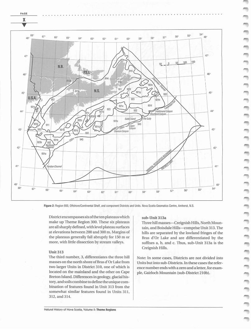
Figure 2: Region 900, Offshore/Continental Shelf, and component Districts and Units. Nova Scotia Geomatics Centre, Amherst, N.S.
District encompassessixofthe ten plateaus which make up Theme Region 300. These six plateaus are a ll sharply defined, with level plateau surfaces a t elevations between 200 and 300m. Margins of the plateaus generally fall abruptly for 150 m or more, with little dissection by stream valleys.
Unit 313 The third number, 3, differentiates the three hill masses on the north shore of Bras d'Or Lake from two larger Units in District 310, one of which is located on the mainland and the other on Cape Breton Island. Differences in geology, glacial h istOJy, and soils combine to define the unique combination of features found in Unit 313 from the somewhat similar features found in Units 311 , 312, and 314.
Natural History of Nova Scotia, Volume II: Theme Regions
sub-Unit 3 13a Three hill masses- Creignish Hills, North Mountain, and Boisdale Hills- comprise Unit 313. The hills are separated by the lowland fringes of the Bras d 'Or Lake and are d ifferentiated by the suffixes a, b, and c. Thus, sub-Unit 313a is the Creignish Hills.
Note: In some cases, Districts are not divided inca Units but into sub-Districts. In these cases the reference number ends with a zero and a letter, for example, Gairloch Mountain (sub-District 210b).
..............................................................
BOUNDARIES
In this classification system, boundaries are defined by biophysical characteristics. For example, the rock types found in Region 300 are more resistant than those in surrounding Regions. As a result, isolated and well-defined hill masses have been formed by differential erosion of the soft and hard rocks. These hill masses are sufficiently elevated above the surrounding landscape to create distinctive climates. The more severe climate of the hills has led to the dominance of forest types quite different from the surrounding lowlands. Bedrock geology is also reflected in the generally thin soils over bedrock.
In the case of Theme Region 300, the distinctive regional climate is created by the elevation, which has evolved from differences in bedrock geology, which in tum have determined the nature of surficial materials. Climatic boundaries are therefore sharply defined and coincide with topography, bedrock geology, and soil boundaries.
Theme Regions Among the eight Regions, only two sets of boundaries are ill-defined. Both are cases where regional climate is not determined by topographical and geological breaks in the landscape. All other boundaries of regions are easily identified by abrupt topographical breaks attributable to underlying geological structure. The two ill-defined boundaries are: 1. Atlantic Coast (Region 800): Wind and salt spray
prevent normal growth of trees along the exposed Atlantic coast. Headlands and islands are frequently barren of trees. Inland, spruce is the most hardy tree and may dominate the forest for up to 8 km from the coast. As conditions become kinder inland, maple and birch begin to appear; other species grow according to local conditions. The inland boundary of the coastal forest varies considerably and cuts across all geological and topographical features. The high water mark provides boundaries with Region 900.
2. Plateau-Taiga (Region 100): Extreme exposure to
No. Name Regional Regional Regional Climate
100 Plateau-Taiga exposed plateau -high winds
200 Highlands highlands-short summers
300 Avalon Uplands uplands-high precipitation
400 Atlantic Interior interior-warm summers
500 Carboniferous interior-Lowlands warm summers
600 Triassic interior-Lowlands warm summers
700 Fundy Coast Fundy-moderated interior
800 Atlantic Coast Atlantic coast-mild winters, high winds
Table 1: Terrestrial Theme Region climate, vegetation, and geology.
Region District Unit sub-Unit (geographic)
Vegetation
taiga-spruce
fir
maple-birch-fir
spruce (maple)-hemlock-pine spruce (maple)-hemlock-pine spruce-hemlock-pine transition
spruce, barrens, and dunes
Hjitat I
based upon physical
description
Geology
ancient high plateau
ancient high plateau
resistant fault blocks
Meguma Group and granitic intrusions
Carboniferous sediments
Triassic sandstones
Basalt and fault blocks
Meguma Group and granitic intrusions
I Vegetation association
I based upon biological
description
Plant and animal species inventory
Table 2: The hierarchical system used in the Natural History of Nova Scotia allows landscape features to be mapped at various levels of detail.
PAGE
xi •

PAGE
xii . . . . . . . . . . . . . . . . . . . . . . . . . . . . . . . . . . . . . . . .
winds stunts tree growth on the highest parts of the Cape Breton highlands. Although a large area is identified as taiga in the vicinity of the National Park, a variety of smaller areas of taiga occur in exposed locations to the north and south. Occurrence of wind-dominated taiga does not reliably correlate with topographical conditions.
Districts Various dominant environmental criteria are used to define Districts. Each District has one defining characteristic, which is usually an element of the physical environment, most often bedrock geology. Surficial materials, landforms, and vegetation are also used in some circumstances. Frequently, the occurrence of the dominant factor is closely linked with other environmental conditions. For example, within the Carboniferous Lowlands (Region 500), a very distinct District (540) is defined by Kingsville soils. These soils are derived from the Scotch Village Formation in which flat -lying strata give a very level surface. The formation produces heavy clay soils which have very poor surface drainage and slow internal drainage. As a result, large organic deposits have accumulated. The Scotch Village Formation occurs over an area wider than the District, and the peat bogs cover an area smaller than the District. Therefore, the District boundary in this case is a compromise between the two soil formations.
The selection of the dominant characteristic on which a District's definition depends is thus a matter of judgement.
Units Most major enVironmental factors do notvarywithin each Unit. A significant change in any one of these factors is in fact what differentiates one Unit from another. This does not imply that Units are homogeneous, but that environmental conditions create recurring patterns. For example, within the Atlantic Coast Region (800), a District with a dominance of abundant coastal sediment (District 830) is recognized; in turn, four Units are recognized as follows:
831 long, shallow estuaries with extensive salt marshes '
832 eroding drumlins, islands, and isolated sand beaches
833 shallow large estuaries, salt marshes, and sand beaches
834 coastal islands
These Units have many similarities, but at least one major factor is different in each. Within the Unit, a repetitive, recognizable sequence of major envi-
Natural History of Nova Scotia, Volume II: Theme Regions
ronmental factors occurs. Boundary conditions are usually well defined as, for example, between Units 833 and 834: coastal islands occur east of Owls Head, and sandy beaches occur west of Owls Head. Estuaries to the west are characterized by salt marshes, but those to the east ofShip Harbour are generally smaller and without significant salt marshes.
OFFSHORE THEME REGIONS
Classification of the Offshore/ Continental Shelf (which includes the continental slope) follows a similar approach, using a hierarchy of Districts, Units, and subUnits (see Figure 2). The Nova Scotia offshore is part of the North Atlantic Ocean, with which it shares broad similarities in physical oceanography, and plant and animal communities. Local variations within theRegion principally reflect changes in productivity of the biological communities (e.g., upwelling or mixing zones) or localization of species (e.g., stocks, or localized warm-water fauna). The foot of the continental slope and the area just beyond, as included within political boundaries, has been chosen as a convenient limit of the Region, but, as noted, many of the features of the biological communities can be extended to cover the rest of the North Atlantic. This approach is consistent with biological classification systems for oceans previously developed for marine conservation4.s in which the whole of the Nova Scotia continental shelf falls into the Acadian-Boreal Zone, one of several broad divisions of the ocean based on animal and plant distributions. The Acadian-Boreal Zone extends from Newfoundland to Cape Cod and includes the Gulf of St. Lawrence. The biota is essentially boreal (between tropical and subarctic) in character.
Districts in Region 900 are geographically distinct areas based principally on depth and the topographical divisions of the continental shelf and slope. 6 The divisions of Inner, Middle, and Outer Shelf have been extended to include parts of the Gulf of Maine and Northumberland Strait. These are areas broadly similar in topography and geological origin and are thus consistent with the "District" definition used for the Nova Scotia landmass. As well, the Districts tend to have distinctive physical oceanographic and biological features, although boundaries often do not exactly coincide, owing to the mobile and variable nature of the ocean. For instance, the waters immediately adjacent to the coast and falling within the Inner ShelfDistrict are biologically different from waters in the Middle Shelf District, owing to freshwater influences and temperature extremes. Similarly, the Outer Shelf and Scotian Slope districts have distinctive physical and biological processes.·
..............................
Units within Districts are based on both geological and biophysical features. In the Inner Shelf District, Units have a highly local nature, with characteristics reflecting special geological or biological features. The six Units are defined by features such as tidal regime, degree of circulation and heating, and local sediment and bedrock conditions. Districts further offshore (the Middle Shelf and Outer Shelf) have less of a local character, but they are usually distinct in terms of topography and depth (e.g., banks, basins, saddles) and have distinct biological features related to depth and sediment type. For example, banks tend to have significant populations of suspension-feeding organisms such as Sea Scallop and Ocean Quahog that are not present in the deeper areas surrounding the banks.
Many of the Unitdivisionssupportrecognizedhabitat classifications6 such as soft bottom, corresponding to the bottoms in basins and deeper areas of the continental shelf (Units 922 and 932); insular environments (Sable Island, District890, on Sable Island Bank, Unit 931e); submarine canyons (Unit 932); upwelling areas (included in Units 911, 912, and 931); topographic highs (offshore banks, Units 921 and 931); naturally deep holes (basins, Unit 922); and watercirculation bodies (gyres, District 940).
COMPARISON WITH OTHER SYSTEMS
During the preparation of the biophysical classification used in the Natural History of Nova Scotia, reference was made to other systems under development. Some apparent differences require explanation.
Systems Plan for Provincial Parks and Protected Areas The revision of the Natural History of Nova Scotia was planned as a parallel and coordinated project with systems planning for provincial parks and protected areas. As the work proceeded, it was found that in some areas the boundaries of Districts and Units on the land were not sensitive enough to adequately meet planning requirements. As a result, some boundary changes were made, and all of the Regions, Districts, and Units were renumbered in a way different from the Theme Regions numbering. The 77 "Natural Landscapes" that have been identified and named for parks planning purposes have been identified at the end of each District or Unit description. Information used to define these "Natural Landscapes" is on file with the Parks and Recreation Division of the Nova Scotia Department of Natural Resources. This information is the basis of a
. . . . . . . . . . . . . . . . . . . . . . . . . . . . . . . .
major initiative for new parks and protected areas in the province. 7•
8•9
Federal Ecozone and Ecoregion Mapping The Centre for Land and Biological Resources Research of Agriculture Canada has recently10 brought together a summation of several years of work by federal agencies through publication of a provisional map of "Terrestrial Ecozones and Ecoregions of Canada." U nderthis system, Nova Scotia is described as part of the "Atlantic Maritime Ecozone," and the province is further divided into eight "Ecoregions":
137 Atlantic Coast 141 Cape Breton Highlands 142 Nova Scotia Highlands 143 Maritime Lowlands 145 Annapolis-Minas Lowlands 150 Fundy Coast 153 Southwest Nova Scotia Uplands
These "Ecoregions" are further subdivided into 25 "Land Resource Areas" (LRAs) which in some cases are the same as the Districts used in the Natural History of Nova Scotia. The differences between the two systems result from the level of detail required at the national and provincial levels. The two systems are sufficiently similar to be used together without much difficulty.
Federal Marine Region Mapping Mapping and description of "Marine Regions" was initiated by Parks Canada as a basis for national marine parks planning and has since been considered for marine environmental quality monitoring by Environment Canada. This work was carefully considered when describing the components of Region 900 of the Natural History of Nova Scotia. In the federal system, Nova Scotia waters fall within two "Marine Realms" (26 Gulf of St. Lawrence and 27 Atlantic) or within four "Marine Regions" (4 Gulf of St. Lawrence, 5 Atlantic, 6 Bay of Fundy, and 7 Magdalen Shallows). Natural History of Nova Scotia provides detailed descriptions of these areas.
REGIONAL DESCRIPTIONS
Each regional description includes information on the Region's character, geology, landscape development, climate, soils, vegetation, fauna, sites of special interest, associated topics and habitats. Additional subjects are included as required, and in some cases headings are combined.
As previously described, a hierarchical approach is used. For any particular Unit, the reader would
Theme Regions: Natural History of Nova Scotia, Volume II
PAGE
xiii ...
PAGE
xiv • .......................................................... "
want to first read the Region description, then the District description, and finally the Unit description; more specific information will be found at each succeeding level of description. Associated Topics and Habitats are not repeated in the District and Unit descriptions if they were first noted in the Region description.
Twenty-one figures illustrate the relationship of the Regions, Districts, and Units to each other, topography, and geological structure. The block diagrams are schematic depictions of the landscape; particular locations are used to assist the reader's orientation.
Much is still to be learned about the natural history of Nova Scotia. Readers are encouraged to submit any information that might contribute to a fuller understanding of the Units.
"Sites of _Special Interest" listed in each Unit or sub-District description are drawn from several sources: the final report of the International Biological Programmes' Conservation of Terrestrial Environments, Maritime Provinces Committee, which identifies proposed ecological conservation sites; a list of provincial parks and park reserves (where each is named, but for many no detailed information is available); and the personal knowledge of many of the reviewers listed in the acknowledgements.
The information under the "Proposed Parks and Protected Areas System" is a cross-referencing of numbered "Natural Landscapes" andnamesof"Candidate Protected Areas" currently in use by the Nova Scotia Department of Natural Resources.
"Associated Offshore Units" are offshore areas abutting the coastal part of the District or Unit. "Associated Coastal Units" are land areas abutting offshore Units.
''Associated Topics" are Topics described in Volume I that are of particular relevance to the Region, District, or Unit.
"Associated Habitats" are Habitats that are of particular importance in the Region, District, or Unit.
••••••••
References 1 Lacate, D.S. {compiler) (1969) Guidelines for
Biophysical Land Classification. Publication 1264. Department of Fisheries and Forestry, Canadian Forestry Service, Ottawa.
2 Wiken, E. {1986) Terrestrial Ecozones of Canada. Ecological Land Classification Series 19. Lands Directorate, Environment Canada, Ottawa, 26 pp.
3 Davis, D.S., P.L. Stewart, R. Loucks, and S. Browne (1994) "Development of a Biophysical
Natural History of Nova Scotia, Volume II: Theme Regions
Qassification of Offshore Regions for the Nova Scotia Continental Shelf." In Cooperation in the Coastal Zone, edited by P.G. Wells and P.J. Ricketts. Coastal Zone Canada '94 Conference Proceedings, vol:5:2149-57. Coastal Zone Canada Association, Bedford Institute of Oceanography, Dartmouth, N.S.
4 Ray, G.C., B.P. Hayden, and R. Dolan (1982) Development of a Biophysical Coastal and Marine Classification System. In National Parks, Conservation and Development: The Role of Protected Areas in Sustaining Society, edited by J.A. Mcneely and K.R. Miller. Proceedings of the World Congress on National Parks, Bali, Indonesia, Smithsonian Institution Press, Washington, D.C., 39-44.
5 Salm, R.V., and }.R. Clarke (1984) Marine and Coastal Protected Areas: A Guide for Planners and Managers. International Union for the Conservation of Nature and Natural Resources, Gland, Switzerland.
6 King, L.H., and B. MacLean (1976) "Geology of the Scotian Shelf." Marine Sciences Paper 7. Geological Survey of Canada Paper 7 4-3. Canadian Hydrographic Services, Department of the Environment and Geology, Survey of Canada, Ottawa.
7 Lynds, A, and J.M. LeDuc (1993) "Understanding and Protecting Biodiversity at the Landscape Level in Nova Scotia." In Protecting Our Natural Heritage, proceedings of a workshop on biodiversity and protected areas in Atlantic Canada, Environment Canada, Dartmouth, N.S., 15-19.
8 Leduc, J.M., and AD. Smith (1992) "System planning for protection-oriented provincial parks in Nova Scotia." In Science and the management of protected areas, edited by J .H.M. Willison, S. Bondrup-Nielsen, C. Drysdale, T.B. Herman, N .W.P. Munro, and T.L. Pollock, proceedings of an international conference, Acadia University, Wolfville. Elsevier, Amsterdam, 139-144.
9 Nova Scotia Department of Natural Resources (1994) A Proposed Systems Plan for Parks and Protected Areas in Nova Scotia. Nova Scotia Department of Natural Resources, Parks Division, Halifax, N.S. 20 pp.
10 Ecological Stratification Working Group (1993) "Ecoregions of Canada," provisional map, scale 1:7,500,000. Agriculture Canada, Research Branch, Centre for Larid and Biological Resources Research, and Environment Canada, State of the Environment Reporting, Ottawa.
F ~
~
~
F' ~
(F'
rm ~
~
~
~
F
~
~
~
F' ~
F
~
~
~
~
~
~
~
~
~
~
F' ~
A note to the reader
The following list of references is by no means comprehensive, but will assist the reader in finding additional information related to the topics discussed in Volume II of the Natural History of Nova Scotia. Readers are also encouraged to refer to "Associated Topics" and "Associated Habitats" in Volume I, as listed at the end of each of the Unit descriptions in Volume II.
Additional References
Benson, D.W. and G.D. Dodds (1977) The Deer of Nova Scotia. Department of Lands and Forests, Province of Nova Scotia. Halifax. 92 pp.
Banfield, A.W.F. (1974) The Mammals of Canada. University of Toronto Press, Toronto. 438 pp.
Catling, P.M., B. Freedman and Z. Lucas (1984) The Vegetarian and Phytogeography ofSable Island, N.S. Proceedings of the Nova Scotian Vol.34:181-247. Halifax.
Erskine, A.J. (1992) Atlas of Breeding Birds of the Maritime Provinces. Nimbus Publishing Ltd, and the Nova Scotia Museum. Halifax. 270 pp.
Gilhen, J. (1974) The Fishes of Nova Scotia's Lakes and Streams. The Nova Scotia Museum, Halifax. 192 pp.
Gilhen, ]. (1984) Amphibians and Reptiles of Nova Scotia. The Nova Scotia Museum, Halifax. 162 pp.
Howe, C.D. (1912) in Fernow, B.E. (1912) Forest Conditions of Nova Scotia. Commission of Conservation, Ottawa. (Published by permission of the Department of Crown Lands, Nova Scotia)
Loucks, O.L. (1962) A Forest Classification For the Maritime Provinces. Proceedings of the Nova Scotia Institute of Science, Vol.25: 85-167. Halifax.
Peterson, R.L. (1966) The Mammals of Eastern Canada. Oxford University Press, Toronto. 465 pp.
Rowe, J.S. (1972) Forest Regions of Canada. Canadian Forestry Service Bulletin 1300. Ottawa.
Scott, W.B. and M.G. Scott (1973) Freshwater Fishes of Canada. Fisheries Research Board of Canada, Bulletin 184, Ottawa. 966 pp.
Scott, W.B. and M.G. Scott (1988) "Atlantic Fishes of Canada" In Canadian Bulletin of Fisheries and Aquatic Sciences No. 219. Ottawa. 713 pp.
Wright, B. (1989) The Fauna of Sable Island. Curatorial Report #68. The Nova Scotia Museum, Halifax.
Theme Regions: Natural History of Nova Scotia, Volume II
PAGE
XV
•