u.d.a.t. report east mesa - · pdf file82nd abg-deev mark killian ... "conglomerate...
TRANSCRIPT

w
U.D.A.T. Report East Mesa
Urban Design Assistance Team, Rio Salado Chapter, American Institute of Architects

East Mesa Urban Design Assistance Team
National Team Members
Gary Hack, AICP; Cambridge, Massachusetts, Chair Thomas Laging, AIA; Lincoln, Nebraska Kirby Lockard, FAIA; Tucson, Arizona William Morrish, AIA; Los Angeles, California
Local Team Members
James Abell, AIA, LA; Tempe Don Larry, AIA; Mesa Marley Porter, AIA; Tempe
Student Team Members - School of Architecture Arizona State University
Randal Blair Steve Christiansen Jarrett Jensen Richard Potosnak
Facilitator & Editor
Steering Committee
Stuart Siefer, AIA, Chair James Abell, AIA, LA Wayne Balmer, AICP Michael Fifield, AIA, AICP Jesse McDowell, AIA Eric Paul, AIA Loras Peacock Bob Saemisch, AIA Russell Weymiller, AIA John Williams
Mesa City Council
Al Brooks, Mayor Charles K. Luster, City Manager Dave Guthrie Ross Farnsworth Pat Blake Peggy Rubach Willie Wong Keno Hawker
Michael Fifield, AIA, AICP City of Mesa Staff
Wayne Balmqr, AICP; Planning Director Loras Peacock; Planner I

Rio Salado AIA - Board of Directors 1987
Marley Porter, AIA, President James Abell, AIA, LA, Pres. Elect. Jesse McDowell, AIA, Treas./Sec. Linda Ward, Exec. Sec. Stuart Siefer, AIA Gordon Boles, AIA Richard Goewey, AIA Bruce Kimball, AIA Brad Rinehart, Assoc. AIA John Kane, Assoc. AIA
Advisory Committee
Bob Saemisch, AIA, Chairman CSA Architects
James Abell, AIA, LA James Abell & Associates Architects
Wayne Balmer, AICP City of Mesa - Planning Director
Ross Bern MDHC Architect
Bob Bresnahan City of Mesa - Airport Director
Daniel Brock, AIA Brock, Craig & Thatcker Architects
John Congrove Salt River Project
Bruce Crandall City of Mesa - Asst. Public Works Manager
II
Joseph Domzalski MegaCorp, Inc.
Bob Evans Evans Management Co.
Michael Fifield, AIA, AICP ASU - School of Architecture
Donald Fuller Planning and Zoning Chairman
Howard Godfrey City of Mesa - Community Development Manager
Steve Griffin, AICP City of Mesa - Town Center Development Director
F.B. Gulledge Salt River Project
Joel Gunning Superstition Springs Development Company
Mike Hutchinson City of Mesa - Asst. City Manager
Richard Isaac 82nd ABG-DEEV
Mark Killian Sunny Mesa Realty
Karl Kohlhoff City of Mesa - Water Resource Coordinator
Wayne Korinek City of Mesa - General Services Manager
Donald Larry, AIA CSA Architects
Jesse McDowell, AIA Essley, Millet, McDowell Architects
Gene Meeker Mesa Chamber of Commerce

Dave Olney McDonnell Douglas
Eric Paul, AIA Eric Paul, AIA Architects & Associates
Loras Peacock City of Mesa - Planner I
Marley Porter, AIA Porter, Pang, Deardorf & Weymiller, Architects
Eric Rasmussen Development Economics
Britt Ripley, AIA Ripley-Erickson
Peggy Rubach City of Mesa - Councilmember
Mike Ryan Spookhill Homeowners Association
B p t Siefer, AIA Siefer Associates Architects
Abdul Slatewala, AIA Abas All Architects
Dean Sloan City of Mesa - Public Works Manager
Dave Udall Udall, Shumway, et al.
Doug Vance Mesa Public Schools
John Williams Charles Kober Associates
i
Special thanks are also due to Mr. Gary Clancy and the Uni-Copy Corporation for the use of the Sharp SF-8600 Photocopier during the workshop; to John Kane and Tom Reilly for photo documentation; and to Rich McLaughlin for word processing.
Ill

I
IV

Introduction The R/UDAT (Regional/Urban Design Assistance Team) program is a public service of the American Institute of Architects. The R/UDAT process begins when a local government or community organization recognizes a local urban design problem and asks the AIA for help. The AIA responds by fielding a team of experts to work with that community. The major focus of the team takes place during an intensive, four day workshop located in the study area. Since the first R/UDAT study in 1967, over 100 workshops have taken place across the country.
The City of Mesa was impressed by the results of another R/UDAT conducted in Gilbert, Arizona (directly south of Mesa) in 1985, administered by the Rio Salado/AIA, but modeled after the national R/UDAT. Like Gilbert, Mesa is growing rapidly. In fact the City of Mesa, as the second fastest growing city of itasize in the U. S., has major concerns regarding growth and the resulting land uses. Because of the rapid changes and because the city was about to begin a major update of its general plan, the Gam® saw the opportunity to reffliest assistance from the RSC/AIA. Again, because of time constraints, the East Mesa UDAT has been administered by the Rio Salado AIA, following the guidelines established by the national organization.
The purpose of the East Mesa UDAT has not been to master plan the city. Instead, the East Mesa UDAT has attempted to identify and enhance existing conditions which have the potential to improve the future environment. This booklet is a summary of the four-day workshop which involved four nationally known urban designers from across the country in association with local Rio Salado AIA members and graduate architecture students from Arizona State University. The workshop was conducted February 6 through February 10, 1987, after many meetings with citizens which formed an East Mesa UDAT Advisory Committee.
Many of the recommendations in this book can be used to supplement various elements of the Mesa General Plan. Other suggestions may result in changes for specific conditions before they can be considered further. Still other recommendations under close scrutiny may not be cost effective. The city is under no obligation to implement any of the recommendations. However, the future of Mesa is being considered now. Monetary costs must be weighed against social cost. If the City of Mesa wishes to become a city known for its outstanding qualities, it must take this opportunity to pursue a direction which places a quality environment for its inhabitants at the forefront.
V

VI
Table of Contents
• East Mesa — Settlement Becoming a City 1
• Comments: East Mesa 2
• Urban Context 3
• History 4
• Size Comparisons 6
• Existing Conditions 8
• Proposals in the Works 10
• Urban Design Concept 14
I. Desert Parkway 16
n. Pathway to the Mountains 20
III. Greenways in the City 22
IV. The Superstition Commercial Spine 24
V. Neighborhood Patterns 26
VI. Streetscape Opportunities 31
• Conclusion M. 34
• Action Agenda M M 35
VII

East Mesa - Settlement Becoming a City
Mesa is a development success story: the second fastest growing city of its size in America, rapidly becoming the major center of the East valley. And East Mesa is where the story is being written. Dozens of large and small new developments compete for the apparently limitless market of retirement couples, snowbirds and households attracted to the area because of its job and lifestyle opportunities. Yet, among Mesans who are prepared to look beyond the next project announcement, there is a nagging discomfort over what the area is becoming.
We asked Mesans how they would describe the rapidly urbanizing area on the East edge of their city. "Land waiting for development," "patchwork," "pure potential," and "a new frontier" were some of the responses. They had little positive to say about the area and it evoked few pleasurable images. They worried that new development seemed to have little in common with the older parts of the city. Most of all, they lamented the absence of a guiding vision of what the area should become. "What will we think of the area in ten or twenty years?" they wondered.
It is difficult to pause in the midst of a boom, take stock and chart a course for the future. In Mesa, looking ahead has often meant thinking about infrastructure needs --the water supplies and lines, roadways, sewers, gas and electricity that will be needed to service future development. Utilities are the business of Mesa's city government and it has conducted its business sucessfully enough to avoid the need for a property tax, surely the largest city in America without one. Mesa knows how to deal with infrastructure! One speaker observed that the city is the best planned and maintained city in the country — from the ground level down.
Mesa is of course much more. Its school system has an excellent reputation. It is a city of churches and there are many recreation oppor tuni t ies . Downtown redevelopment has successfully improved the image of the original city core. But beyond that area there is little visible evidence that the city is more than the work of its private developers.
What more could it be?
Private developers recognize the value of amenities to their sites. They create lakes or golf courses or recreation centers and surround them with housing or commercial uses. They turn their backs to the outer edges of their developments where they meet the city, as if nothing of importance exists beyond. And what exists beyond more often detracts than ^adds to what they have created.
Therein lies the challenge: to create a "public city" in East Mesa that is as considered and valued as the private amenities which developers create. The arteries, entries and public spaces of the city form the collective image of a place. Like front lawns on private houses, they communicate how we wish to be seen.
This is a propitious moment in the development of East Mesa. Freeways are about to be extended and created, a new desert park is in the planning stage, and a complex of educational and civic facilities is taking shape near Power & Brown Roads. But so far they are being considered on their own; there is no thread to knit them together into a tapestry. That is the subject of our proposals.
1

Comments: East Mesa
Some Hopes and Fears About the Future of East Mesa
Mesans have a strong sense of attachment to family, school, churches and community. The question is how to become more cosmopolitan without losing what we have.
We are searching for middle ground between total market dominance and total planning control.
People relate to their immediate neighbors. There is a need for connecting fiber between developments.
Are urban villages relevant here? Can they be created without political balkanization?
East Mesa doesn't have the critical mass to form a sense of community. Can it be created?
The area should have multiple identities. There are landscape differences, leisure activity choices, lifestyle preferences which may vary.
There is a need for at least two large industrial parks to attract jobs to the area.
There is enormous recreation potential.
Balance is the key.
2
What East Mesans are saying about East Mesa
"Open Desert"
"Waiting to be Developed"
"Cafeteria Style Land Use"
"Hodge-podge Development"
"Checkerboard"
"Pure Potential"
"Underutilized"
"Last Frontier"
"Old Age Ghetto"
"Conglomerate Community"
"Greatly Misunderstood"
"Transportation Nightmare in the Winter"
"Killing Field for Two Decades of City Council Members"

Urban Context of Phoenix/Mesa Area
Often times when looking at the street systems of the Phoenix/Mesa metropolitan area, the vast scale and the repetitiveness seems to produce a homogenous fabric of "sameness." One city seems to flow into another.
Upon second look one can see that within this grid, there exists several types of urban lifestyles. The major cities of the valley, like Phoenix, Scottsdale, & Mesa, contain within them many smaller communities. Each community seems to contain:
a) an older central grid b) linear corridors, which parallel major boulevards c) environmental communities, found either in old
agricultural areas, such as citrus groves, or in desert zones on alluvial plains at the edges of the perimeter mountains.
It is the availability and access to these small urban communities which gives Mesa, Phoenix, and Scottsdale their unique quality, as an urban context from which to construct a future city.
3

History
Mesa's Growth
Mesa was founded in 1878 by Mormon settlers from Idaho and Utah. The settlement was incorporated in 1883. The site selected for the new community was on a higher flat plateau (or "mesa" in Spanish), located on the south side of the Salt River overlooking the broad Salt River Valley to the west. The young agricultural com^Rnity grew relatively slowly in both population and incorporated area until 1930. In that year Mesa had a population of 3,700 people and an incorporated area of approximately one square mile. By 1940, these figures had virtually doubled to 7,200 people and 2.35 square miles. Between 1940 and 1980, the population and area of Mesa continued to double approximately every ten years. By January 1987, the incorporated area of Mesa stood at 100 square miles with an estimated population of 268,000 people.
4
mtm ^
BBS 9 7N
@WSo-\eno
Wbt{eoo

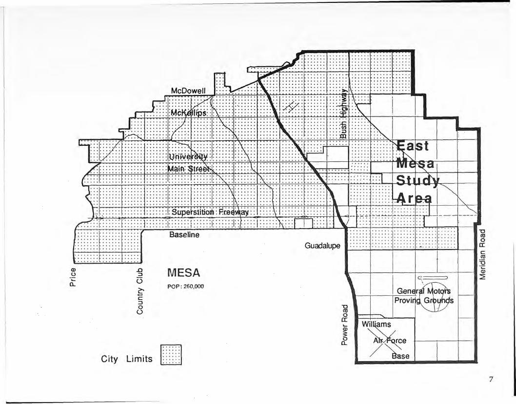
The "Mesa Planning Area"
Mesa is a city of 268,000 people located approximately 15 miles east of downtown Pheonix, in the eastern portion of Maricopa County. The Mesa Planning Area irjRides ^^^S:orporated area of the City of Mesa and those areas to the southeast and northeast of the city proper which the City Council has expressed an intent to annex within the next 20 to 30 years. The Mesa Planning Area covers approximately 150 square miles and is bounded on the north by the Salt River Indian Reservation and the Tonto National Forest, on the south by the Western Canal and Baseline Road, on the east by the County line, and on the west by the City of Tempe. About 100 square miles are currently within the city limits.

Size Comparisons
The City of Mesa, when it reaches its ultimate planned geographical size, will comprise approximately 150 square miles. The East Mesa study area is 101 square miles. The enormous magnitude of planning for the area of East Mesa can be demonstrated by comparing the size of other well known cities. The cities shown on this page, San iFrancisco, Paris (city proper), and Manhattan, are 47, 41, and 22 square miles respectivel^Bln fact, all three offl&ese cities together would almost fit into the East Mesa study area.
PARIS POP 2,317227
SAN FRANCISCO POR 678,974
MANHATTAN POP. 1,430,000
6
CD
o -O
o
c 3 O
o
MESA POP: 260,000
City Limits
" O CO o cc ©
o Q.
Z5>-
Williams
»rce
ise
vnnams
Afc/^qrc

Existing Conditions
Existing Urban Fabric
At the present time, Mesa is centered around the old grided core of the city and the string of development along the Superstition Freeway, especially in the Fiesta Mall area near Alma School.
East Mesa is a zone of individualized planned residential developments with little in the way of nearby support facilities.
Existing Circulat ion
The movement systems which channel the automobile to and from destinations in and around the city is a powerful force which shapes the city.
Apache Trail and the Superstition Freeway are major east/west corridors which have stretched the city eastward from its original centralized grid; cutting across the city north/south streets such as Country Club, Alma School, and Power Road.
These north/south streets move large volumes of traffic to destinations through Mesa neighborhoods to recreational areas in Tonto National Forest and to other cities in the North and South.
The city in its present state is criss-crossed by crosstown traffic. In East Mesa the movement system is incomplete.
8

I — UMTS*.
| 5fiCWl&//tCfi£.
k j — i
Water Zones
The older section of town west of the second canal near Greenfield has an ample water system grandfathered from the original agricultural systems tied to the Salt River Project (SRP).
The area described as East Mesa, was never an agricultural community. As opposed to West Mesa, East Mesa is attempting to grow directly from a dry desert condition.
The water resource is derived from whatever savings can be produced from the SRP existing system and from supplemental water reclamation strategies. Even with these savings, the amount of water available is limited.
In East Mesa, existing water capacity limits development to a ratio of 10 people per acre. South of the Supersition Freeway, it drops to 5 people per acrgii
Under present legislation, water in the SRP zone cannot be transfered outside of the area.
In addition to the issue of quantity, the pattern itself is a powerful form on the landscape. The canals, drainage retention ponds and channels afford a unique opportunity to create linkages and points of destination within the city.
Water is the "history" of the place. Therefore, the city's form should enhance its sense of place through the further introduction of the system into its public realm.
9
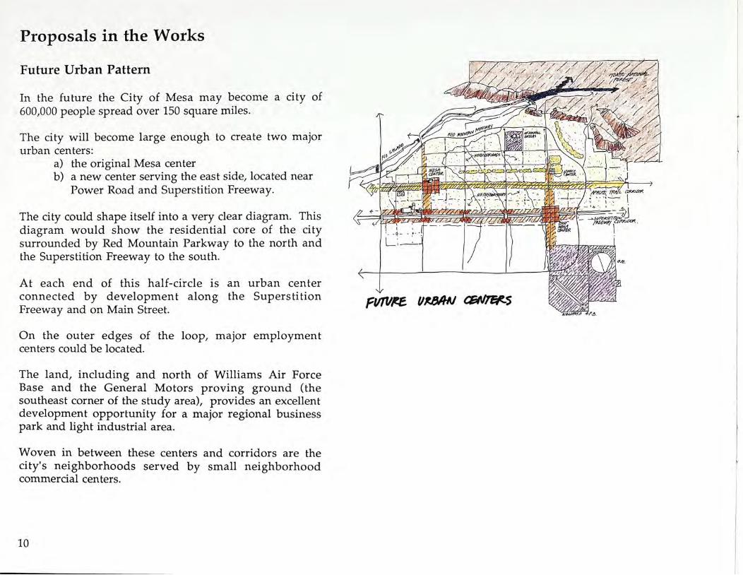
Proposals in the Works
Future Urban Pattern
In the future the City of Mesa may become a city of 600,000 people spread over 150 square miles.
The city will become large enough to create two major urban centers:
a) the original Mesa center b) a new center serving the east side, located near
Power Road and Superstition Freeway.
The city could shape itself into a very clear diagram. This diagram would show the residential core of the city surrounded by Red Mountain Parkway to the north and the Superstition Freeway to the south.
At each end of this half-circle is an urban center connected by development along the Superstition Freeway and on Main Street.
On the outer edges of the loop, major employment centers could be located.
The land, including and north of Williams Air Force Base and the General Motors proving ground (the southeast corner of the study area), provides an excellent development opportunity for a major regional business park and light industrial area.
Woven in between these centers and corridors are the city's neighborhoods served by small neighborhood commercial centers.
10
pvrvtB V*BAU asfi/r&s

bBSBKT COMBS
TO 7tfa. ary
The Desert Comes to the City
Looking at the city of Mesa without a street grid, what becomes visible is a potential to organize the city into a set of districts which arranges individual housing projects into neighborhoods.
For example; one of the unique opportunities in connecting East Mesa to the West side is a chance to connect the heart of the city to the Usery Mountains desert landscape through a desert pathway system under an existing power line transmission easement right-of-way north of and parallel to University Drive.
When completed, new developments will feel connected to the native landscape rather than isolated within the center of the city' street grid.
In the future, the Usery Mountains and the desert will begin to feel like an integral district within the city, rather than only a distant backdrop.
11

Future Circulation
With construction of the Red Mountain Parkway, the City of Mesa will become a more coherent system.
For example, for a family seeking to head for the Tonto National Forest, the new parkway will provide an easy bypass around the city's neighborhoods. It will also create a vehicular thread which will lasso the outer edge of East Mesa into the cultural core of the city of Mesa "proper."
Instead of being on the outer edge of town, East Mesa will then be integrated into a cental area of the City of Mesa.
12

mv*z cmt sFficz
Future Open Space
The future open space system of Mesa can be created by a combination of linear open space linkages which will tie East & West together, creating a fabric of neighborhoods linked together by an open space infrastructure.
The THREE components are: 1) The Red Mountain Parkway should become an
open space scenic corridor - celebrating the various environmental microclimates which ring the city.
2) Turning the existing canal system into an interconnecting open space system which moves people north and south across town.
3) Connecting the heart of the city to new parks in East Mesa and to the desert areas of Tonto National Forest. By connecting and adding to the existing desert gardens and neighborhood retention pond "greens" under power transmission lines north of University Ave., a linear park system could extend from the heart of Mesa towards the new Spook Hill Park area at the foot of the Usery Mountains in East Mesa.
13

Urban Design Concept
In the previous diagrams it was illustrated how the elements of open space, circulation, districts, creation of new urban centers and a scenic parkway can be used to tie the pieces of the city together.
By overlapping these diagrams into a composite diagram, the idea for an urban design concept which integrates the eastern and western sides of Mesa into a coherent metropolitan place becomes apparent. The concept can be seen as a plan for creating the perception of Mesa as a place where people interact with others as well as with the surrounding natural landscape. The elements described in the urban design concept diagram are ways in which a diverse and varied set of residential and work environments combine as an urban whole.
14
We offer a concept to guide the development of East Mesa into a coherent whole. It has six main elements:
I. The Desert Parkway
II. The Pathway to the Mountains
III. Greenways in the City
IV. The Superstition Commercial Spine
V. Neighborhood Patterns
VI. Streetscape Opportunities

VF&fol VES/6AJ CONCEPT 15

I. Desert Parkway
Rather than simply building the perimeter freeway as a typical roadway that rushes traffic from place to place, we suggest making it a desert parkway — a 34 mile linear park connecting all the communities along the way. One section, where the new roadway will border the CAP canal and Spook Hill Park, has already been conceived as that. Elsewhere, the parkway could take its character from the surrounding lands, capitalizing on views for the driver, and fitting the roadway sensitively into its landscape. It should vary in character as it moves from the Lehi lowlands to the Red Mountain desert highlands to the flat plain south of Mesa. Natural area and trails in each area along the way will provide a new city scale amenity to adjacent neighborhoods, offsetting any negative connotation the roadway may bring.
Our perceptions of a place are shaped by what we see from the road.
Mesa is a very large city covering 150 square miles.
The planned 34 linear miles of Red Mountain Parkway will loop and enclose the city with the potential of providing a scenic overview of the city.
Instead of having people remembering Mesa from the congestion of Main Street or from traveling below grade on the Superstition Freeway, the development of a scenic parkway can solve TWO problems:
a) inviting the visitor to experience the diverse quality of the land.
b) connecting the natural amenities found in East Mesa to the landscapes of West Mesa into a scenographic panorama of the whole city.
16

&&§•• li&^>i
WmMMM r r_J e e e r | a | o . n7I7o » p a r TZTy-a
* U ) e ^ i e n d « L e h i *
i§§! 1P
llI^ili£Sii$S
4K& *f OS
M U e h i prt r k u><iy
The trip along the parkway might pass by the dry rocky landscape of the Rio Salado near Price and Country Club...
...eastward across the Lehi lowlands of riparian plant material and citrus...
17

* H ET e A T P> A K) e I T I O M *
...up over the northern edge of the mesa edge at Thomas Road towards the Usery Mountains.
18
ft&$% i^^'&li^^^^^'W*^^5^?5 *!P tefcj miSIP
* (i^^^f t4fcJMT>iKJ <^Ia£ANtA •H
' , „»S. '
Swinging south across the face of the Usery Mountains and along the Central Arizona Project canal, the traveler will have a spectacular panoramic view of the valley to the west and south.

Swinging away from the mountains, the driver will turn southeast and have an elevated view over the urban landscape of East Mesa towards Williams AFB.
• V I E W PPiOH PiEP MO^MTAIM SCfiMIC P A C k W A y «
19

II. Pathway to the Mountains
The future Spook Hill Regional Park and future East Mesa City Service Center form a wedge of open land connecting Power Road to the mountain parks. There is a magnificent opportunity to extend this open space corridor into the heart of the built-up city by aquiring and landscaping the United States Bureau of Reclamation easement just north of University Avenue. It could become a way to open land for cyclists, joggers, hikers and those just out for a stroll.
20
The Desert Walk Idea The "desert walk" established by the residents of Dreamland Villas in the overhead electrical easement which runs through the neighborhood should be encouraged and taken as a model for the city's open space network.
Design, construction, and maintenance help should be made available to this voluntary effort. The easement should only be used as a drainageway if the Desert Walk can be preserved.

Linkage and Character The overhead electrical easement in which the Desert Walk has been established has the potential to link up over nine miles of central Mesa, from the public school at Stapley Drive to the Spook Hill Recreational Area.
Where this extended Desert Walk crosses Roosevelt canal and enters the citrus groves, the citrus trees should remain so that the landscape character of this open space corridor changes to reflect the history of Mesa's growth.
Open Space Spine The innermost segment of the Desert Walk could change character again, toward a clearer reflection of the broad lawns and parks of the older Mesa.
21

III. Greenways in the City
The North-South irrigation canal system offers still another set of potential pathways lacing the city. They could become places for strolling and cycling, new front doors for adjacent neighborhoods and, as agricultural uses further decline, possibly places for active recreation. The canal system could provide a unique flavor to this inland city.
Infrastructure
Original Infrastructure The infrastructure which has allowed Mesa to grow and prosper began with the canals the Hohokam Indians extended from the Salt River.
Expanded Infrastructure Mesa's expansion has been structured on three circumferential "growth rings" formed by successive irrigation canals and their section line laterals.
In this sense, the newest canal for the CAP is simply a statewide extension of a growth pattern which originated in Mesa.
Future Infrastructure The extension of the water-delivery agricultural infrastructure upon which Mesa has grown pervades the entire urban area.
It is easily the city's most unique characteristic and important urban design opportunity.
22

Pedestr ian Links
Opportunities for pedestrian linkages exist all along the irrigation canals.
Distinctively designed pedestrian bridges and a tree-lined walkway along one side of each canal would encourage walking for pleasure, recreation, errands and neighboring.
The canal walks could become prominades which allow a kind of gathering not now available in Mesa.
Such linkage systems should be considered as a reinvestment in the infrastructure, deserved by inner-city people of Mesa who typically have most of their utility fees spent on peripheral development.
23

IV. The Superstition Commercial Spine
There is the need for a new commercial zone in the city, sized to the half million it will soon accommodate. The Superstition Freeway is the logical generator for this activity, connecting Mesa to its larger region. We envision a new East Mesa commercial center where Power Road meets the Superstition Freeway. To encourage a greater concentration there, we suggest joint use of the expressway right-of-way, with commercial structures bridging the freeway on air rights.
East Mesa Center at Superstition Freeway
The East Mesa Center is recommended as a primary location for major multi-use, high intensity activities including regional Class A office space, regional shopping mall , public ^ s t i t M i o n s , and a conference/entertainment center.
The area should feature structured parking facilities, multiple parcel development, extensive public improvements and height limitations tied to the intensity of retail activity provided at ground level.
The center should be a major pedestrian precinct characterized by a fine grain network of shops at grade and ample linkages to any multi-level commercial and entertainment areas.
A major public gathering space in conjunction with hotel and entertainment areas should be included.
The program for the center should take extensive advantage of freeway air rights for a retail mall linking the north and south sides of the freeway.
24

V i e w of Retail Mall from Superstition Freeway: Looking East
The center at Power Road and the Superstition Freeway should be easily recognized from Ae freeway as a very important point in the East Valley grid.
Vista at Power Road Looking North
Internally the East Mesa Center should have a strong urban image. In structuring this image, the offset at Power Road and Baseline creates a design opportunity to "close" the grid with a major vista, and develop a monumental shaft of space.
25
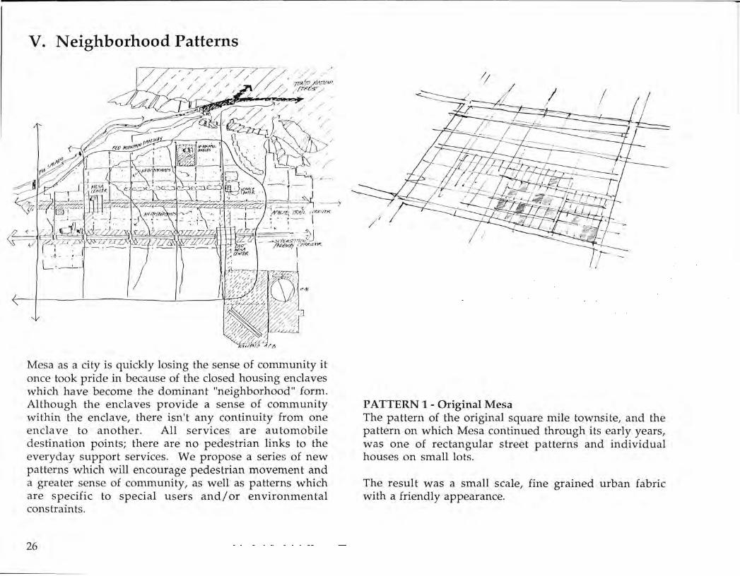
V. Neighborhood Patterns
Mesa as a city is quickly losing the sense of community it once took pride in because of the closed housing enclaves which have become the dominant "neighborhood" form. Although the enclaves provide a sense of community within the enclave, there isn't any continuity from one enclave to another. All services are automobile destination points; there are no pedestrian links to the everyday support services. We propose a series of new patterns which will encourage pedestrian movement and a greater sense of community, as well as patterns which are specific to special users and/or e n v i ^ M m ^ ^ S constraints.
26
PATTERN 1 - Original Mesa The pattern of the original square mile townsite, and the pattern on which Mesa coKnued through its early years, was one of rectangular street patterns and individual houses on small lots.
The result was a small scale, fine grained urban fabric with a friendly appearance.

PATTERN 2 - The Enclave Present development patterns have introduced the closed-off walled enclave, often advertised as offe| t | | | "security" and "prestige." When these units stand alone in newly developing areas, thei§|protective form has a certain "frontier" validity. Inside, they have the same small-scaled appearance of older Mesa. From t ie outside, however, they present a cold, exclusive, large-scaled, and visually dull appearance.
PATTERN 3 - Mile-square enclaves More recent developments have increased their scale to close off mile-square enclaves; often developing some interior theme such as golf or lakes.
These enclaves present an even larger exterior scale. They provide no pedestrian links across their boundary arterials and completely close out the various kinds of public buildings which lend the sense of an existing larger community to the public streetscape.
27

PATTERN 4 - The Collective Effect Whatever these various enclave patterns have when they stand alone is lost in their collective effect.
Their closed protective forms look somewhat ludicrous backed up to one another. The lack of lateral pedes t^S linkages and small scaled commercial and public buildings result Mi a very over&ealed, dull streefcsglape.
28
NEW PATTERN 4 - Lateral Pedestrian Connections There is the opportunity to promote a greater sense of neighborliness, by connecting enclaves to each other with pedestrian linkages. If easy, continuous paths were available, residents would be encouraged to walk or bicycle to shopping instead of relying on the automobile.

NEW PATTERN 5 - Small Scale Commercial Nodes Small scale commercial nodes which include a market, drugstore, cleaners, hardware, and other services could form the center of dense housing clusters. These nodes offer a convenient alternative for Mesa's future development.
Such neighborhood centers could extend a radiating network of lighted, landscaped pedestrian walkways so that older, younger, or fitness-interested people of Mesa could live a less car-dependent lifestyle.
NEW PATTERN 6 - Clustered Residential Nodes A similar alternative pattern might be appropriate for highly mobile single or pre-family couples who want to live in Mesa but spend most weekends enjoying nearby recreation opportunities.
They might chose compact clustered condominiums or apartments located near or with convenient access to employment and the freeways linking Mesa to its surrounding regions.
29

NEW PATTERN 7 - Non-destructive Housing Development in the Desert
A final pattern might be appropriate to the development of the extremely desirable high desert in northeast Mesa.
More people may be housed here with less destructive effects if mandatory clustering were enforced; or if encouraged by significant density bonuses for leaving most of the desert untouched.
The marketing of individual "lots" of any size, and the individual utility and roadway connections they necessitate, cut the desert into visually and environmentally meaningless pieces.
30

VI. Streetscape Opportunities
BWP mA
— T
11 pi
i
• WPSC
1—
\p^\
SSS
Li Sb.«w
Z2
HI , „ ,
5^sv
W 3 K
1 /
%v+ —™
I—
w BSffi
^
j £
/
i
• J ( l TL d j **
ijiii
Bte:—
/
'
-1
f 1-
Between Mesa and East Mesa and beyond, Main Street is the historic route. Now dotted with motels, trailer sales lots and drive-in commercial outlets, it is a street in search of a fuiare. It should become a fine landseaped boulevard as it is in parts of centeal Mesa, and the location for the main East-West transit routes of the future. Above all, it needs a theme and consistent elements of streetscape. Power Road is an equally important street to the emerging East Mesa area, connecting our proposed new commercial node with the cluster of educational and civic buildings near Brown Road. Rather than filling the right-of-way with traffic lanes, wouldn't it be better to create a linear park, for pedestrians and cyclists along one side. It would thus become a "special street in the urban pattern."
31

Main Street Looking East
MR& landscape program moves east from west Mesa and west from Power and Main Streets. It is g r a d u ^ ^ extended to the complete length of the street over a course of 25 years.
Tall palms emphasize the scale and spinal character of the degaser Main Street strip. They form a sky grid and lend continuity to the diverse texture of businesses along the strip.
A Public Transipprogi|a|n begins along Main Street as a service using historic street railway cars on rubber tires. Service is gradually extended for the Main Street spine, to | | | | u d e Power Road, and is eventually linked with the Phoenix transitfsystem.
32
Power Road & Main Streets: Looking north toward Red Mountain
Landscape treatment is lifitensified at intersection to reflect its importance within the grid.
Tall trees (like palms) interlock with the sky providing an experience scaled for both the fast moving car on the grid and the deep setbacks of many of the commercial developments.
A public building or institution is needed to mark a major junction on Main Street.

Main Street at Twin Knolls: Looking East toward the Superstition Mountains
East of Power Road the landscape character of Main Street is more informal. Publicly owned water tower is improved to provide a memorable place marker.
Looking South on Power Road
The right-of-way is singled out north of Main Street for special emphasis on its easwside. Where the right-of-way is narrow, a pedestrian treatment is proposedMncluding landscape materials, ornamental lighting and low walls. Where opportunities present themselves to enlarge the eastern side of the right-of-way, it becomes a lineal parkway|lnking with the high school and desert walk open space system.
33

Conclusion
In the final analv®p, how to create places which are special and memorable is the central issue Mesans face in guiding the development of their eastern frontier. They must be bold enough gestures to stand out in a city that will within a few years no longer be the little sister to Phoenix.
Changing the way Mesa develops will require leadership and persistance. It will not be without its pains and costs. But the need to remake the city later is also not a pleasant prospect.
When growth passes beyond the city limits, what will Mesa be left with?
34

Action Agenda
1 - Initiate Design of Parkway and Linear Park The Red Mountain and San Tan Freeways should be designed as parkways with broad open spaces adjacent. This linear park would take its character from the natural forms of the landscape through which it passes. This new parkway will help knit together the diverse neighborhoods on the perimeter of East Mesa.
2 - N e w Nodes on the Superstition Freeway The new commercial and office center of East Mesa should be located along the Superstition Freeway. In order to coordinate development, joint use arrangements should be negotiated with ADOT to allow development to bridge the freeway. With a 600' right-of-way, the freeway occupies over 70 acres per mile. Decking over a portion of it for development could help tie the two sides together.
3 - Pedestrian/Cycle Ways Along Canals and Easements
The north/south irrigation canals and the east/west United States Bureau of Reclamation transmission easement offer opportunities for new pedestrian and cycle routes interlacing the city. Designs should be prepared for the corridors and negotiations begun w|tre SRP and USBR on use of the corridors.
4 - One Percent for City-wide Facilities While many developers have recognized the value to their projects of providing amenities for use by residents and tenants, the city remains short of capital funds to provide for facilities that are open to residents of the entire city. An additional new development fee equal to one percent of the value of construction could provide ^ y j funds for public recreation complexes, libraries, athletic fields, art museums, children's museums, and other facilities designed to bring residents from many areas of the city together.
5 - Special Districts for Design Advisory Board Review
Rather than scatter the energies of the board across the entire city, it can be most effective if it concentrates its attention on a small number of districts of critical importance to the city pattern. We suggest two such areas: the Main Street Corridor, the historic connection of Mesa with its eastern suburbs, and Power Road, the new heart of East Mesa.
6 - Area Plan for the South-East Quadrant The quadrant south of Guadalupe Road and east of Power Road offers the potential of accommodating major new employment areas, a regional recreation facility and other unique installations. Since it is now largely vacant, it ought to be planned in advance of private proposals to avoid ad hoc responses.
35