uncompahgre watershed plan owners of ditches and canals that is responsible for the operation and...
TRANSCRIPT
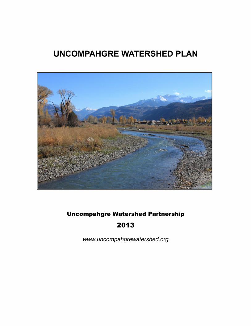
UNCOMPAHGRE WATERSHED PLAN
Uncompahgre Watershed Partnership
2013
www.uncompahgrewatershed.org

UNCOMPAHGRE WATERSHED PLAN
i
Page intentionally left blank

Uncompahgre Watershed Plan
ACKNOWLEDGMENTS
ii
ACKNOWLEDGMENTS The Uncompahgre Watershed Plan would not be possible without generous and substantial support by our m any partners. Funding sources for the project include the Colorado Healthy Rivers Fund, the Colorado Nonpoint Source Pollution Program, and the Blue Water Project from the Royal Bank of Canada.
This project would not be possible without the help of the Western Hardrock Watershed Team and their OSM/AmeriCorps VISTA* Program. The UWP VISTA program was supported by TriCounty Water Conservancy District, the GMUG National Forest, Telluride Foundation, the Western Mining Action Network, and Trust for Land Restoration. Thank you Andrew Madison, Rachel Boothby, and Matthew Jurjonas for joining us in this adventure!
We also wish to thank partners and supporters of the UWP and Uncompahgre community for providing the necessary energy and encouragement to engage in this process. Thank you to the Shavano Conservation District and Colorado Watershed Assembly for acting as fiscal agents. The following organizations participated in the development of the watershed plan and Uncompahgre Watershed Partnership: Ridgway Ouray Community Council, Uncompahgre Valley Association, Selenium Task Force, Painted Sky RC&D, Uncompahgre Valley Water Users Association, Tri-County Water Conservancy District, Mosaic Community Project, City and County of Montrose, Ouray County, Town of Ridgway, City of Ouray, Delta County, City of Delta, Friends of the River Uncompahgre, Colorado River District, Uncompahgre Plateau Project, Trust for Land Reclamation, Red Mountain Project, CSU Extension ,Black Canyon Land Trust, BLM, USFS, USGS, CDPHE WQCD, BOR, NRCS, Division of Parks and Wildlife, DRMS, WHWT, San Juan Corridors Coalition, Gunnison Gorge Anglers, Ridgway State Park, RIGGS, Bio-Logic Inc., Western Stream Works LLC.., City of Ouray Library, Mountain Studies Institute, Idarado Mining.

UNCOMPAHGRE WATERSHED PLAN
EXECUTIVE SUMMARY iii
EXECUTIVE SUMMARY
A. The Watershed
The Uncompahgre River Watershed (HUC 14020006) drains 1,115 square miles (713,876 acres) of the Gunnison Basin in southwestern Colorado, including parts of Delta, Montrose, Ouray, Gunnison, Hinsdale, San Juan and San Miguel Counties in southwest Colorado (Figure 2.1, Table 2.1). The elevation ranges from 14,158 feet at the peak of Mt. Sneffels to 4,915 ft at the mouth in Delta. The Uncompahgre River originates in Lake Como at 12,215 ft (3723m) in the Uncompahgre National Forest. It flows approximately 75 miles northwest past the City of Ouray, Town of Ridgway, City of Montrose, and Town of Olathe and joins the Gunnison River at Confluence Park in the City of Delta.
B. Problems
State water planners have forecast gaps in water supplies which may impact existing water uses
Accelerated snowmelt can cause flooding and threaten storage efficiencies Seasonal low flows in the Uncompahgre River can temporarily reduce in-stream habitat. Segments of the Uncompahgre River and its tributaries are impaired for heavy metals Segments of the Uncompahgre River and its tributaries are impaired for selenium Segments of the Uncompahgre River and its tributaries may be listed as nutrient
impaired when standards are adopted The current regulatory water quality framework does not reflect ambient conditions in
the Uncompahgre River and its tributaries Lack of connectivity and trespass issues has potential to create recreation hazards and
conflicts Rapid development creates new resource demands Lack of formal stormwater management planning in rural communities Parts of the Valley are at risk for flood damage Altered sediment dynamics lead to river instability In-stream and riparian habitat are limited
C. Goals and Objectives
Goal 1) Improve water quality
Restore waters impaired by heavy metals Restore waters impaired by selenium Reduce salt loads Reduce nutrient loads Reduce sediment loads
Goal 2) Improve riverine ecosystem function
Understand the factors that lead to instability and unpredictability of the river channel
Protect environmentally sensitive and recently restored areas. Improve flood management within the Uncompahgre Valley Encourage development of riparian buffers and new wetlands.

Uncompahgre Watershed Plan
EXECUTIVE SUMMARY
iv
Goal 3) Improve seasonal low flows
Identify long-term strategies to augment flows
Goal 4) Improve recreation opportunities
Educate the public about rights, responsibilities and safety hazards
Goal 5) Create a stable stakeholder group
Increase participation in UWP meetings Secure funding for implementation and future watershed coordinator

UNCOMPAHGRE WATERSHED PLAN
TABLE OF CONTENTS v
TABLE OF CONTENTS
ACKNOWLEDGMENTS .................................................................................................. ii EXECUTIVE SUMMARY ................................................................................................ iii EPA NINE ELEMENTS .................................................................................................. vi ACRONYMS ................................................................................................................. vii 1.0 BACKGROUND ................................................................................................ 1-1 2.0 WATERSHSED CHARACTERIZATION ........................................................... 2-1 3.0 REGULATORY SETTING ................................................................................. 3-1 4.0 WATER INFRASTRUCTURE ........................................................................... 4-1 5.0 WATER USE .................................................................................................... 5-1 6.0 RIVER CONDITION .......................................................................................... 6-1 7.0 WATER QUALITY ............................................................................................ 7-1 8.0 ISSUES OF CONCERN.................................................................................... 8-1 9.0 GOALS AND OBJECTIVES .............................................................................. 9-1 10.0 MANAGEMENT MEASURES ......................................................................... 10-1 11.0 MONITORING STRATEGY ............................................................................ 11-1 12.0 EDUCATION AND OUTREACH ..................................................................... 12-1 13.0 EVALUATION OF IMPLEMENTATION STRATEGIES ................................... 13-1 14.0 WORKS CITED .............................................................................................. 14-1 15.0 TABLES .......................................................................................................... 15-1 16.0 FIGURES ....................................................................................................... 16-1 APPENDIX A.................................................................................................................. A

UNCOMPAHGRE WATERSHED PLAN
EPA NINE ELEMENTS vi
EPA NINE ELEMENTS The United States Environmental Protection Agency (EPA) requires all implementation, demonstration, and outreach-education projects funded under Section 319 of the federal Clean Water Act to be supported by a Comprehensive Watershed Plan which includes nine listed elements. The nine EPA required elements, and the location of the plan component addressing these elements are listed below.
A. An identification of the causes and sources
Section 7.5 and Section 8
B. An estimate of the load reductions expected for the management measures
Section 10.3
C. A description of the NPS management measures that will need to be implemented to achieve the load reductions and an identification of the critical areas in which those measures will be needed to implement this plan.
Section 9 and Section 10
D. An estimate of the amounts of technical and financial assistance needed; associated costs, and/or the sources and authorities that will be relied upon, to implement this plan.
Section 10
E. An information/education component that will be used to enhance public understanding of the project and encourage their early and continued participation in selecting, designing, and implementing the NPS management measures that will be implemented.
Section 12
F. A schedule for implementing the NPS management measures identified in this plan that is reasonably expeditious.
Section 10
G. A description of interim, measurable milestones for determining whether NPS management measures or other control actions are being implemented.
Section 10
H. A set of criteria that can be used to determine whether loading reductions are being achieved over time and substantial progress is being made towards attaining water quality standards and, if not, the criteria for determining whether this watershed based plan needs to be revised or, if a NPS TMDL has been established, whether the NPS TMDL needs to be revised.
Section 7.4 and Section 10
I. A monitoring component to evaluate the effectiveness of the implementation efforts over time, measured against the criteria established under item (h) immediately above.
Section 11

UNCOMPAHGRE WATERSHED PLAN
Error! Reference source not found. vii
ACRONYMS AFY – Acre Foot per Year BLM – Bureau of Land Management BMP – Best Management Practice CFS – Cubic Feet per Second CDPS – Colorado Discharge Permit System CDSS – Colorado Decision Support System CHIA - Cumulative Hydrologic Impact Analysis CNHP – Colorado Natural Heritage Program CRBSCP – Colorado River Basin Salinity Control Project CWCB – Colorado Water Conservation Board DMR – Discharge Monthly Report DOLA – Department of Local Affairs DPW – Division of Parks and Wildlife DRMS - Division of Reclamation, Mining and Safety FEMA – Federal Emergency Management Agency FMCRC – Fire Mountain Canal and Reservoir Company FERC – Federal Energy Regulation Commission GMUG – Grand Mesa Uncompahgre Gunnison National Forest HUC - Hydrologic Unit Code ICIS – Integrated Compliance Information System ISDS - Independent Sewage Disposal System ISF – In-stream Flow M&E – Monitoring and Evaluation List M&I – Municipal and Industrial Mg/L - Milligram per Liter NCNA – Non-Consumptive Needs Assessment NPDES – National Pollution Discharge Elimination System NPS – Non-Point Source Pollution NRCS – Natural Resources Conservation Service RCMAP – Reconfigured Channel Monitoring and Assessment Program SWE – Snow Water Equivalent SWSI - Statewide Water Supply Initiative TDS – Total Dissolved Solids TMDL – Total Maximum Daily Load TSS – Total Suspended Solids TVS – Table Value Standard WBID – Water Body Identification WQCC – Water Quality Control Commission WQCD – Water Quality Control Division WRAS – Watershed Restoration Action Strategy WSERC - West Slope Environmental Resource Council WWTP – Waste Water Treatment Plant USBOR – United States Bureau of Reclamation USDA – United States Department of Agriculture USEPA – United States Environmental Protection Agency USFS – United States Forest Service USGS – United States Geological Survey
ACRONYMS

UNCOMPAHGRE WATERSHED PLAN
BACKGROUND 1-1
1.0 BACKGROUND
1.1 Uncompahgre Watershed Partnership
The Uncompahgre Watershed Partnership (UWP) is a collaboration of citizens, nonprofits, local and regional governments, and federal agencies dedicated to understanding the Uncompahgre Watershed and developing and maintaining a consensus based watershed plan. The UWP was created in spring, 2007, when regional groups and concerned citizens applied for a watershed-planning grant.
The UWP has worked to create Public Education Forums on topics from stormwater, wildlife, and irrigation to mining. They have organized educational programs for youth at Ouray Library and also participated in Public events like the Ridgway River Festival and Lake Appreciation Day in an education and outreach capacity. There have been mine tours, river assessments, movie nights, cleanup projects, and conferences all held with the goal of creating a sense of ownership of our watershed as well a better understanding of it.
Through the stakeholder group, these local outreach events, and the Mining Committee, the UWP works to create a better informed public on the current issues of the Uncompahgre Watershed as well as the importance of watershed health as it relates to water quality. We want to serve as a resource for the community. Our mission is to protect and restore water quality in the Uncompahgre River through coordinated community and agency efforts. We want a healthy river in a thriving community!
1.2 Purpose of watershed plan
The Uncompahgre River watershed is host to several municipalities, a variety of types of land use, and many interest groups. As a result there are issues that the need to be addressed in a collaborative planning process by all vested stakeholders to ensure the long term health and protection of our watershed. A watershed plan outlines all of these issues of concern and the process for seeking out solutions. The plan is to serve as a tool that guides the community through the process of river restoration and protection.
Watershed planning is an inclusive approach that supports environmental protection, economic development, and quality of life issues. With stakeholder involvement and the flexible framework of the plan itself management actions can be taken using sound science and appropriate technology. The watershed plan addresses the issues at hand in the context of what partners and what best management practices (BMPs) can be utilized to create improvements. The is framed in the plan by characterizing existing conditions, identifying and prioritizing issues, defining the objectives of management, developing protection and remediation strategies, and implementing the selected actions. As the watershed group and plan progresses in time and achievement, the plan is to be updated to include all actions taken and an accurate reflection of the most current conditions.
1.3 Stakeholder Concerns
Over the course of its existence, the UWP has hosted stakeholder meetings, conferences, and public forums designed to education and gain sentiment about the Uncompahgre River watershed. The UWP wants to know the concerns of the stakeholders and the issues of the watershed. Meetings were held in Ridgway, Montrose and Delta. A compiled list of the concerns and issues collected throughout the existence of the UWP are as follows:

UNCOMPAHGRE WATERSHED PLAN
BACKGROUND 1-2
Water supply gaps
Accelerated snowmelt
Development
Seasonal low flows
Water quality impacts from inactive mines
Selenium mobilization
Recreation
Inaccurate regulatory framework
Nutrients
Stormwater management
Sedimentation
Point Source Pollution
Riparian habitat and aquatic communities
Heavy metal build-up on substrate in Red Mountain Creek and the upper Uncompahgre River is toxic to aquatic life. The metals are from a combination of natural erosion and runoff from inactive mine infrastructure. Several sections of the Uncompahgre River are impaired waters for heavy metals.
Deep groundwater percolation from irrigated agriculture, irrigation cannals, ponds, septic systems and gravel pits mobilizes selenium from the mancos shale. Selenium is toxic to fish and water fowl. The Uncompahgre River and its tributaries below Montrose impaired for selenium.

UNCOMPAHGRE WATERSHED PLAN
WATERSHSED CHARACTERIZATION 2-1
2.0 WATERSHSED CHARACTERIZATION
2.1 Location
The Uncompahgre River Watershed (HUC 14020006) drains 1,115 square miles (713,876 acres) of the Gunnison Basin in southwestern Colorado, including parts of Delta, Montrose, Ouray, Gunnison, Hinsdale, San Juan and San Miguel Counties in southwest Colorado (Figure 2.1, Table 2.1). The elevation ranges from 14,158 feet at the peak of Mt. Sneffels to 4,915 ft at the mouth in Delta. The Uncompahgre River originates in Lake Como at 12,215 ft (3723m) in the Uncompahgre National Forest. It flows approximately 75 miles northwest past the City of Ouray, Town of Ridgway, City of Montrose, and Town of Olathe and joins the
Gunnison River at Confluence Park in the City of Delta.
2.2 Physiography and Geology
Topography
The topography of the Uncompahgre Watershed is highly varied, ranging from snow capped mountains to barren desert lands. Major landforms include the Uncompahgre River Valley, the Uncompahgre Plateau to the west, the San Juan Mountains to the south, and the Gunnison uplift and Adobe badlands on the east.
Adobe badlands: The adobe badlands, locally referred to as the “dobies” are characterized by abrupt sloping hills of Mancos Shale dissected by rugged winding canyons. The dobies extend from Delta County, through Montrose County, and into Ouray County and are extensively used by off-road vehicles.
Uncompahgre Plateau: The Uncompahgre Plateau is the remnant of an ancient highland. The ninety-mile long Plateau flanks the west edge of the watershed, extending from the San Juan Mountains to the Colorado River. The Plateau is incised by many deep canyons separated by flat-topped mesas.
Cimarron Ridge: The jagged skyline east of Ridgway is consists of volcanic lava flows and ash layers. The rounded slopes below are weathered Mancos sculpted by glacial moraines.
San Juan Mountains: The San Juan Mountains are a rugged, steep, scenic and highly mineralized mountain range in the Rocky Mountain system. Natural features of the mountain range include spectacular breccia pipes, iron-red stained red mountains, and U
shaped valleys, cirques, horns, and tarns carved by glaciers.
Uncompahgre River Valley: The Uncompahgre Valley is a comprised of multiple river terraces that run parallel to the river. These terraces make up a broad, highly dissected valley with a gentle to moderate down-valley slopes.
The Uncompahgre River begins in the high San Juan Mountains in Como Lake. The River flows north through Poughkeepsie Gulch and through the historic Red Mountain mining district where it is joined with Red Mountain Creek at the head of the Uncompahgre Gorge. Other major tributaries join the Uncompahgre River as it flows north. Canyon Creek joins Uncompahgre at Box Canyon, in Ouray just below the Ouray Hydro Dam and Dallas Creek contributes and meets the River system at Ridgway Reservoir.
Downstream of Ridgway Reservoir, the Uncompahgre River is joined by Cow Creek. The Uncompahgre River flows through the Town of Colona towards the City of Montrose. North

UNCOMPAHGRE WATERSHED PLAN
WATERSHSED CHARACTERIZATION 2-2
of Montrose, the Uncompahgre gains flows from Cedar Creek and Spring Creek as it moves towards the Town of Olathe. The Uncompahgre River gains flows from the Uncompahgre Plateau via Dry Creek approximately five miles above the confluence with the Gunnison River in the Town Delta. Flows north of Colona are highly regulated by a complex system of water diversions and canals.
Geology and Soils
The Uncompahgre Watershed covers portions of two distinct physiographic regions: the Southern Rocky Mountains south of Ridgway and the Colorado Plateau to the north (Worcester, 1920). Differences in geology, landscape and climate between the regions create varying watershed conditions (Figure 2.2).
The exposed sedimentary geology in the lower portions of the watershed records the transition from terrestrial flood plains to a marine environment during the Triassic through the Cretaceous Periods (White, et al., 2008). The Mancos Shale and Dakota formations were deposited over red rocks of the Morrison Formation as the landscape was overcome by the Western Interior Seaway. Mancos shale in particular, is a known contributor of dissolved mineral salt and selenium to the Uncompahgre River. Mancos Shale is also high in clay content and will shrink and swell in response to water.
Beginning in the late Cretaceous period and ending 35 to 55 million years ago during the Tertiary period, a great mountain building event known as the Laramide Orogeny occurred. This mountain building process lifted the Cretaceous Sea and created an extremely varied landscape – a mountain region dominated by igneous cone-shaped peaks rising above mesas, ridges, basins and benches formed from sedimentary materials.
The San Juan Mountains are a mixture of pre-Cambrian metamorphics with mid-Tertiary Andesitic volcanic intrusions. The Watershed encompasses part of the Silverton Caldera, which is characterized by numerous large veins that are radial to the caldera and formed some 10 million years after the volcanism. A cluster of small, but very rich orebodies formed in breccia pipes associated with post-caldera volcanic intrusions, most notably near Red Mountain Pass (Nash, 2002). The crystalline rocks within the watershed contain several minerals in extractable quantities, including gold, lead, silver, and copper.
Oxidation of sulfide ores and dissolution of gypsum deposits in the highly mineralized mountains are a likely source of sulfate in the Uncompahgre River. As a result, conductivities in the Uncompahgre River in Ouray are derived from calcium sulfate instead of calcium bicarbonate (Tuttle and Grauch, 2009).
Remnants of the glacial activity that sculpted the valley are still visible in Ridgway’s wide valley floor. When the glaciers melted at the end of the Pleistocene Period 10,000 years ago, the ancient Uncompahgre swelled to many times its present size. Alluvial deposits filled the U-shaped valley bottom between Ouray and Ridgway, flattening the valley floor.
Soils of the valley range in age from recent alluvial deposits in the flood plains to the well-weathered soils of higher terraces and benches. Flood plain soils of the lower Uncompahgre River are largely alkaline deposits over a relatively high ground water table. The alluvial deposits contain relatively coarse, unconsolidated and stratified soils of poorly graded, well-sorted sand and gravel derived from igneous and sedimentary rock formations. More developed soils range in texture from silty clay loam to very fine sandy loam (USDA 1967).

UNCOMPAHGRE WATERSHED PLAN
WATERSHSED CHARACTERIZATION 2-3
2.3 Climate and Hydrology
Climate
Climate varies substantially between the southern and northern parts of the watershed because of the significant differences in altitude and landscape features. The climate in the northern region of the watershed is semi-arid and low relative humidity. Precipitation is less than ten inches per year (Figure 2.3). Maximum monthly rainfall usually occurs in August (1.12 inches), reflecting the influence of summer convection thunderstorms. Winters are mild with occasional snowfall and summers are hot and dry. Average temperatures range from 30F in the winter and 90F in the summer. The growing season is over 140 days (Table 2.2).
Above 7,000 feet, the climate changes to more mountainous conditions with an increase in precipitation and cooler temperatures. Annual precipitation averages over 30 inches in the high mountains. Winters are harsh, with 140 inches of snow in Ouray each year. Average monthly snowpack is greatest in March and April. Temperatures range from 10F in the winter and 80F in the summer. The growing season is limited to less than 120 days.
River Flows
The Uncompahgre River is primarily a 3rd order stream that drains 1,115 square miles of the upper Colorado River Basin. The Uncompahgre River is the largest tributary to the Gunnison River. The headwaters are located in the Uncompahgre National Forest, originating in Como Lake. The USGS hydrological unit code is 14020006.
There are two dams on the Uncompahgre River, a small diversion dam in the Uncompahgre Gorge (Ouray Hydrodam), and Ridgway Dam below the town of Ridgway which forms Ridgway Reservoir. Approximately 850,000 AFY from the Gunnison River are diverted to the valley via the Gunnison Tunnel. The Uncompahgre is non-navigable except at high water.
Selected streamflows in the Uncompahgre Watershed are continuously measured at a number of real-time flow gaging stations. Table 2.3 lists the active real-time flow gages, period of record, and mean annual stream flow. The highest annual stream flow, 420 cfs, occurs at the South Canal. The South Canal outfall is the point of discharge for water diverted by the Gunnison Tunnel.
The seasonal flow patterns of the Uncompahgre River include a low, base-flow period that runs from August through April followed by a high flow period that runs from May through July. Peak flows occur in May and June due to snowmelt runoff. Average flow rates above the Town of Ridgway range between 100 and 200 cfs with peaks as high as 2,000 cfs (Figure 2.4). At Delta the average flows range between 150 to 400 cfs with peaks as high as 5,500 cfs. Unlike the Uncompahgre at Ridgway, elevated fall flows are common in the lower Uncompahgre River (Figure 2.5). This is in part due to declining end-of season irrigation withdrawals and increased fall precipitation.
Ridgway Reservoir
Ridgway Reservoir is the Uncompahgre Watershed’s largest reservoir. Ridgway Dam and Reservoir were constructed of as part of the US Bureau of Reclamation’s (USBR) Dallas Creek Project in 1987. Tri-County Water Conservancy District (TCWCD) is responsible for

UNCOMPAHGRE WATERSHED PLAN
WATERSHSED CHARACTERIZATION 2-4
operation of the dam and outlet works. The Project was created to increase water supplies for irrigation, municipal and industrial purposes, as well as flood control.
The total capacity of the reservoir is 84,410 acre-feet. The active storage pool - water that is available for delivery - is about 59,396 acre feet, of which 28,100 is currently allocated for municipal and industrial uses in Montrose, Olathe, Delta and surrounding rural areas. The irrigation water (11,200 AF) provided by the Dallas Creek Project is used to augment supplies for the UVWUA and the Uncompahgre Project. The Reservoir also maintains a large inactive reservoir pool, approximately 20,000 acre-feet, to support recreation, fish and wildlife enhancements. Ridgway Reservoir also provides flood control by creating storage capacity to help reduce spring floods from melting snow (Fosha, 1995b). The outlet works, fed from a pipe near the bottom of the reservoir, has a capacity of 500 cfs (Fosha, 1995b).
TCWCD and USBR coordinate the releases of Ridgway Reservoir to minimize supply risks to water rights holders. With the exception of extreme drought years (e.g. 1993 and 2002), Ridgway Reservoir generally fills to full capacity. TCWCD and the BOR have coordinated a "no spill" policy for the reservoir in order to prevent a fishery loss over the spillway. Winter release rates from the reservoir are typically less than 100 cfs during the mid-winter months and in the range of 450 to 800 cfs during the early spring runoff months (CWCB 2004).
Groundwater
Groundwater in the Uncompahgre Watershed is directly related to the local geology. Sedimentary rock aquifers are shallow and have highly variable yields. Hydraulic properties of igneous aquifers vary considerably due to differences in rocky type, density and orientation of joints and fractures. Although insignificant in terms of total volume withdrawn, alluvial groundwater is important for irrigation, public and domestic water supplies, and livestock uses. The alluvium of the Uncompahgre River Watershed consists of clay, silt, sand, gravel and cobble deposits. Alluvial water levels range from 1 to 37 feet, with an average of 15 feet (CGS 2003).
Snowpack
The Uncompahgre River is a snowmelt driven stream. Average monthly snowpack in the San Juan Mountains is greatest in March and April (Figure 2.6). Historically, the average meltout date happened around July 15 and occurred over a period of 3 months. In 2009, snowmelt occurred on June 5 and was complete in only 1.5 months (Figure 2.7). This trend of shorter and earlier spring snowmelt has major implications for flooding and water storage in the Uncompahgre Watershed.
One cause for the early spring runoff in the Uncompahgre River and Colorado as a whole is the “dust on snow” phenomenon. According to Chris Landry, Executive Director of the Center for Snow and Avalanche Studies in Silverton, there were 12 dust events in winter 2008/2009. Dust events result from dust plumes originating in Arizona and Utah that settle in on the snow in the Rocky Mountains. The red dust increases the absorption of solar radiation, which dramatically accelerates snow melt.
Flooding
Major flood events in the Uncompahgre Watershed are often the result of snowmelt, sometimes augmented by localized cloudburst storms. Historical flood records along the Uncompahgre River date back to the late 1800s. The highest recorded peak flow on the
UNCOMPAHGRE WATERSHED PLAN
WATERSHSED CHARACTERIZATION 2-5
Uncompahgre River at the USGS Delta gage was 5,800 cfs on May 15, 1984, before construction of Ridgway Reservoir. This flood event corresponds to largest known flood event on the Gunnison River, which resulted from rapid snowmelt, intensified by heavy rain.
In general terms, flooding occurs when a water body exceeds its “bank-full” capacity. Riverine flooding generally occurs as a result of prolonged rainfall, or rainfall that is combined with soils already saturated from previous rain events. The area adjacent to a river channel is its floodplain. The Federal Emergency Management Agency (FEMA) refers to the “floodplain” as the area that is inundated by the 100-year flood. 100-year flood events have a one percent chance of happening in any given year.
The Delta, Montrose and Ouray counties each address flood hazard potential in their hazard mitigation plans. The 2008 Ouray County Multi-Hazard Mitigation Plan warns of “potentially catastrophic” effects from flooding in the City of Ouray. The 2008 Montrose County Pre-Disaster Hazard Mitigation Plan notes that the county FIRM maps, created in 1984, do not give an accurate depiction of the current floodplains and structures. The plan indicates that the area near the confluence of the Uncompahgre River and Spring Creek is at the most at risk for property damage from flash floods. The Delta County Multi-Hazard Mitigation Plan lists the Uncompahgre River as a primary flood area.
2.4 Environmental Resources
Vegetation
The Uncompahgre Watershed’s ecological setting is a reflection of its diverse geology, topography, climate and landuse. The watershed spans two physiographic regions, six ecoregions (Table 2.4, Figure 2.8) and nearly 10,000 feet of elevation change. As a result, there is an immense variety of vegetation in the Uncompahgre Basin, ranging from alpine tundra to desert shrub communities.
Land cover in the Uncompahgre Watershed consists of a mix of range/grassland (44%), forested land (36%) and cropland (13%). Approximately 5% of the land is classified as “rock and barren”. Less than one percent of the watershed is residential/ commercial (NRCS 2009).
Major plant associations found in the upper watershed include alpine, Englemann spruce-subalpine fir forests and mixed conifer and aspen forests. Near Ridgway, the environment transitions to Gambel’s Oak-mountain shrublands and Pinyon-Juniper woodlands. Irrigated agricultural lands are concentrated along the river valley and much of the lower portions of the watershed. Pinyon, juniper, and sagebrush cover the outlying salt desert shrub and sagebrush lands in the lower watershed (Figure 2.9). For a more detailed description, refer to the Colorado Natural Heritage Program (CNHP) Natural Heritage Assessment of the Uncompahgre watershed at: http://www.cnhp.colostate.edu/download/reports.aspx.
Wetlands and Riparian Zones
Wetlands and riparian zones in the Uncompahgre Watershed support a diverse array of plants, animals, and plant communities. At low elevations, native riparian vegetation is dominated by narrowleaf cottonwood with an understory of coyote willow or skunkbrush. Between Colona and Ridgway, narrowleaf cottonwood still dominate, but silver buffaloberry, Rocky Mountain juniper, western river birch, and red osier dogwood are increasingly prevalent. Near Ouray, the riparian community transitions to conifers

UNCOMPAHGRE WATERSHED PLAN
WATERSHSED CHARACTERIZATION 2-6
including blue spruce, Douglas fir and white fir are added. Deciduous trees and shrubs such as thinleaf alder, aspen, and Rocky Mountain and Drummond willows are also common. In the Uncompahgre Gorge, subalpine fir and Engelmann spruce take over as the dominant species. Near the headwaters, trees become less frequent, and are eventually replaced by low growing willows or bog birch, and then alpine meadows and wetlands. For a more detailed description, refer to the Colorado Natural Heritage Program (CNHP) Natural Heritage Assessment of Wetlands and Riparian areas of the Uncompahgre watershed at: http://www.cnhp.colostate.edu/download/reports.aspx.
Wetlands and riparian zones provide numerous ecosystem services including wildlife and fish habitat, flood attenuation and storage, sediment and nutrient retention and removal, shoreline stabilization and groundwater discharge/recharge. Riparian zones are extremely important areas for wildlife. It has been estimated that 75% to 80% of wildlife species in the area are dependent on riparian zones for at least part of their lives. Mature cottonwoods provide nesting sites for great blue herons, golden eagles, and neotropical migrant birds. They are used as roosting sites by bald eagles during the winter. Dead trees provide nesting cavities for numerous birds. Most of the waterfowl habitat in the region is concentrated in wetlands along the Uncompahgre River.
Wildlife
Riparian zones are the most species-diverse wildlife habitats in Colorado, providing some or all of the habitat requirements for about 75% of the state’s wildlife. Wildlife habitat within riparian areas varies depending on plant species composition, woodland and shrubland structural characteristics, climate, geologic substrate, surface water regime, adjacent upland habitat type, and level of past and present disturbance. Consequently, different areas support a unique assemblage of wildlife species.
The Uncompahgre Watershed is home to a number of wildlife species. Big game include mule deer, elk, moose, black bear, mountain lion, bobcat, and big horn sheep. The river corridor and lowland areas provide critical migration corridors and winter habitat for elk and mule deer (Figure 2.10). The diverse riparian and canyon habitats support a wide range of wildlife species. Riparian habitats are essential for many species such as frogs and toads, beaver, muskrat, waterfowl, and wading birds. For a more detailed description of wildlife occurrence by county, refer to the DPW’s Natural Diversity Information Source: http://ndis.nrel.colostate.edu/aspresponse/spxbycnty_res.asp
Aquatic Communities
The streams, lakes and reservoirs are home to a limited aquatic community. Many streams in the lower basin are intermittent and do not support perennial aquatic habitat while habitat in high elevation streams are limited by high gradients, erosive drainages, and severe water quality problems. Wild trout fisheries still exist in the headwaters, but the much of the fish community in the mainstem is highly controlled by the Colorado Division of Parks and Wildlife (DPW). Several streams currently managed as wild trout streams are being investigated as potential Colorado River cutthroat trout conservation streams. Intensive management of the fishery in and above Ridgway Reservoir includes annual stocking of Kokanee Salmon and occasional fingerling trout (DOW 2003).
There are eight fish species native to the Uncompahgre Watershed, including: Colorado pikeminnow, roundtail chub, razorback sucker, bluehead sucker, flannelmouth sucker, speckled dace, mottled sculpin, and Colorado River cutthroat trout. Both the pikeminnow

UNCOMPAHGRE WATERSHED PLAN
WATERSHSED CHARACTERIZATION 2-7
and the razorback sucker are extirpated from the watershed and are thought to have been historically rare in the Uncompahgre River. For a more detailed description of the fishery, refer to the 2003 Gunnison River Basin Aquatic Wildlife Management Plan created by the Division of Parks and Wildlife (DPW).
Species and Areas of Special Concern
The Colorado Natural Heritage Program (CNHP) has identified a number of plant and animal species and communities that are rare or endangered within the Uncompahgre Watershed and eastern Montrose County. This includes 32 major wetland/riparian plant communities, 13 birds, 2 mammals, 1 invertebrate, 1 plant, 1 fish, and 1 amphibian, the majority of which are riparian or wetland in nature. The two most imperiled communities include lower elevation riparian zones and lower elevation semi-desert salt shrublands, known locally as the “adobes”.
A list of state and federally listed species can be found in Table 2.5. Based on quality and location of these elements of special interest, CNHP has designated a number of potential natural areas for the watershed (Figure 2.11). The highest biodiversity sites, outlined in red, are located in the adobes of eastern Montrose County and riparian zones of Dry and Spring Creek drainages.
Invasive Species, Pests and Pathogens
Invasive plants, animals and pathogens cause significant changes in natural ecosystems. Exotic organisms compete with and predate on native species, directly change local environments and alter ecosystem structure and process. Today, an increasing number of invasive organisms are part of the landscape and act as key stressors on the composition and functioning of native ecosystems. Parasites such as Myxobolus cerecralis (which causes whirling disease) and aquatic nuisance species (ANS) such as Catostomus commersonii (white sucker) are already established in the Uncompahgre River. Zebra and Quagga mussles and New Zealand Mudsnails have not yet been detected, but are present in many Colorado reservoirs and streams. Major weeds found in the Uncompahgre Watershed include Canada thistle, Russian olive, tamarisk, hounds tongue, Russian (spotted, meadow) knapweed, cheatgrass, burdock, oxeye daisy, musk thistle, yellow toadflax, leafy spurge, and white top.
Beetle kill is a growing issue in the watershed but is not currently a widespread problem. Most beetle populations are in isolated pockets on the Uncompahgre Plateau and in the Uncompahgre National Forest in the upper watershed (Figure 2.12). The occurrence of Sudden Aspen Decline (SAD) is scattered throughout the watershed, mostly on National Forest lands on the periphery of the watershed. Dead and fallen aspen trees, especially in large quantities can present a loss of habitat for wildlife and an increased wildfire risk.
2.5 Land Use and Growth Trends
Land Ownership
Approximately half of the land in the Uncompahgre River Watershed is owned/ managed for conservation and recreation by the federal government (Table 2.6, Figure 2.13). The US Forest Service (USFS) manages 341,255 acres as the Grand Mesa Uncompahgre National Forest (GMUG) and San Juan National Forest. The Bureau of Land Management (BLM) manages 520,313 acres as general public land and special management areas. There are two
UNCOMPAHGRE WATERSHED PLAN
WATERSHSED CHARACTERIZATION 2-8
federally designated wilderness areas in the Uncompahgre Watershed: the Uncompahgre Wilderness and Mt. Sneffles Wilderness. The National Park Service manages 18,296 acres as part of Black Canyon of the Gunnison National Park. The State of Colorado manages 8,826 acres as Billy Creek and Chipeta State Wildlife Areas as well as Ridgway and Sweitzer Lake State Parks. Most of the remaining land in the watershed is privately owned.
Historic Land Use
The Uncompahgre Watershed has been an attractive place to live and hunt for more than ten thousand years. For centuries, people have relied on the abundant big game and mountain resources of the region. Past inhabitants include transient hunters of the last great ice age, farmers and foragers of the latest formative period, and the historic Ute people who lived in the area for over 500 years.
Prior to irrigation, the Uncompahgre Valley was a barren landscape. The Uncompahgre River and its tributaries frequently dried up. The first attempts of farming in the valley were focused around the river bottom where ditch construction required minimal skill and effort. Near the turn of the century, the valley’s appetite for water exceeded what the Uncompahgre River could supply. The water shortage caused farmers to look 16 miles east to the raging waters in the Black Canyon of the Gunnison River. The federal government started work on the Gunnison Tunnel in 1905. Four years later, September 23, 1909 the tunnel was completed. The 5.8 mile tunnel, dug through bedrock and sandstone, was the second largest reclamation project in the west and cost over 4 million dollars at the time. It supplied 1,000 cubic feet per second to the starving Uncompahgre Valley.
The federal Uncompahgre Project is one of the Bureau of Reclamation’s oldest projects. The Uncompahgre Project contains one storage dam, several diversion dams, 128 miles of canals, 438 miles of laterals and 216 miles of drains. The project draws water from the Uncompahgre and Gunnison Rivers to supply irrigation water to over 66,000 acres in Delta, Gunnison and Montrose counties.
Cultivation of the Uncompahgre Valley would not have happened if not for a mining boom in the San Juan Mountains. Prospecting for mining claims in the San Juan Mountains began in the early 1860’s prior to the American Civil War. By the early 1880’s most major claims had been staked and mines had begun processing ore. The Uncompahgre headwaters drain 4 mining districts. Production value from ore in Ouray County had a gross value of about $111,000,000. The rugged landscape necessitated the construction of large tunnels through the mountains to efficiently haul ore, most of which actually came from the Telluride district. This style of mining resulted in the creation of major complexes for mine production waste on the Ouray County side of the mountains. The major mine complexes include the Idarado mine (Treasury Tunnel), the Revenue Tunnel, and the Camp Bird mine (Nash, 2002).
In July 1890, President Grover Cleveland signed the Sherman Silver Purchase Act which switched currency from a silver standard to a gold standard. This caused the value of silver to plummet. As a result, mining companies went bankrupt and eventually had to shut down and abandon their prospects. Most mines closed or were simply abandoned by 1950. Idarado operated the Camp Bird Mine until the 1990’s and the Ruby Trust Mine still operates today.
In 1983, the State of Colorado filed a Natural Resource Damage lawsuit against the Idarado Mining Company to ensure clean up of the mine site, to mitigate impacts to the aquatic environment, and recover the costs for damages to natural resources under the

UNCOMPAHGRE WATERSHED PLAN
WATERSHSED CHARACTERIZATION 2-9
Comprehensive Environmental Response Compensation and Liability Act (“CERCLA”” or Superfund). The case was settled in 1992 when a final remedy was finalized in court. The cleanup involved stabilizing and revegetating 5 tailings piles installation of hydrologic
controls at 2 Idarado draining mines and 13 non-Idarado properties. The sites has been
remediated, as required by a Consent Decree, but additional work is required because the
specified performance objective of a 50% reduction in zinc loading to Red Mountain Creek has
yet to be achieved.
Current Land Use
Agriculture and Irrigation
Agriculture activities contribute substantially to the local economy. The 2007 total market value of agricultural products in Montrose and Ouray counties was $70,764,000 (U.S. National/Agricultural Statistics Service, 2007 Agricultural Census). Approximately 11% of the watershed is irrigated agriculture which is aggregated along the river valley in Montrose and Delta Counties (Figure 2.14).
Extractive Resources
Hard-rock mining currently contributes more to the local economy as a tourist destination than an extractive industry. However, there is a growing interest in reviving hard-rock mining in Ouray County. As of June 2011, there were 5 active permits for hard-rock materials in Ouray County.
Sand, gravel and construction materials are currently the most common mining products in the watershed. Gravel mining happens where the gravel deposits are - often in streams and in riparian areas. As of June 2010, there were 10 active sand, gravel and aggregate mines in the Uncompahgre Watershed.
Urban Areas
Montrose is the agricultural hub of the western slope and largest municipality in the Gunnison Basin. It sits at the junction of US Highways 550 and 50. Highway 550 parallels the Uncompahgre River and bisects the Watershed. All the major municipalities are located on the River/Highway corridor. Therefore, stormwater and wastewater are potential water quality concerns.
The transportation network in the Uncompahgre Watershed is largely rural with very few paved roads. Paved roads are generally limited to major transportation corridors and side streets of Delta and Montrose. Side streets in Ouray and Ridgway as well as the network of county roads are largely dirt and gravel.
Recreation and Tourism
Recreation and tourism activities are also economically important to the Uncompahgre Valley. Popular activities include jeeping, hunting, backpacking, fishing and wildlife viewing. The Alpine Loop Scenic Byway attracts 15,000 visitors, mainly 4WD, ATV and off-road motorcycles to the dirt roads between Lake City, Silverton and Ouray. Yankee Boy Basin, renowned for its wildflowers, is also a popular four wheel drive and hiking destination. Each winter, the Ouray Ice Park attracts hundreds of ice climbers. Tourists can also enjoy themselves in region’s many hot springs.
Ridgway State Park is the gem of the Colorado State Park system. It attracted 331,775 visitors in 2009/2010. Visitors to Ridgway State Park spend about $20 million annually in local communities (Corona Research, 2009). The visitors are attracted to the crystal clear
UNCOMPAHGRE WATERSHED PLAN
WATERSHSED CHARACTERIZATION 2-10
water in Ridgway Reservoir and the Gold Medal trout fishery in Pa-Co-Chu-Puk. Hunting is also a popular activity in the watershed. Hunters are attracted to both the San Juan Mountains and the Uncompahgre Plateau. The 2007 economic impact from hunting and fishing in Montrose and Ouray counties was $31,610,000 (BBC Researching and Consulting, 2008).
There are multiple public access points on the Uncompahgre River including the Ouray River Walk, Rollins Park in Ridgway, Ridgway State Park, the Uncompahgre Riverway in Montrose, and Confluence Park in Delta. Each park has a pedestrian trail system, fishing access, and wildlife viewing. Rollins Park currently has two constructed waves designed for boaters. Rollins Park is home to the annual Ridgway River Festival.
Growth Trends
The Uncompahgre watershed encompasses the majority of Ouray County, a quarter of Montrose County, and a small fraction of southwestern Delta County. The municipalities include the City of Delta (9,093 ppl), Town of Olathe (1,839 ppl), City of Montrose (18,281 ppl), Town of Ridgway (1,114 ppl) and City of Ouray (885 ppl). The remainder of the watershed is sparsely populated in unincorporated areas with scattered residences.
Over the past twenty years, the Uncompahgre watershed has experienced significant population growth (Table 2.7). The population is predicted to more than double between 2000 and 2035 (DOLA). The largest anticipated growth rates are expected to occur in Montrose County. Growing populations can have significant impacts on water quality, water supply and water management strategies. It is important to consider population trends when developing management decisions that must meet growing demands.

UNCOMPAHGRE WATERSHED PLAN
REGULATORY SETTING 3-1
3.0 REGULATORY SETTING
3.1 Water Quantity
Agencies
For the most part, water supplies in Colorado are managed by the State. This section outlines the state, regional and local agencies responsible for managing Colorado water use.
Colorado Water Court
In 1879, the Colorado General Assembly delegated the duty of setting water right priority dates and amounts to the courts. They review applications for conditional water rights, augmentation plans, and State or Division Engineer enforcement orders. The water courts are where all water rights are filed, defended, challenged, and adjudicated. The water court for the Gunnison Basin, Division 4, is located in Montrose. For more information about Colorado Water Court, see:
http://www.courts.state.co.us/Courts/Water/Index.cfm
Colorado Division of Water Resources
The Colorado Division of Water Resources (DWR or Office of the State Engineer) is an agency within the Department of Natural Resources. The DWR administers water use based on the prior appropriation doctrine. DWR employs regional water commissioners to enforce the decrees and water laws, ensuring the priority system is followed. For more information about the DWR, see the website at: http://water.state.co.us/
Colorado Water Conservation Board
The Colorado Water Conservation Board (CWCB) was created in 1937 by the Colorado General Assembly to provide policy direction on water issues. The CWCB’s mission is to conserve, develop, protect, and manage Colorado’s water for present and future generations. The agency maintains expertise in a broad range of programs and provides technical assistance to further the utilization of Colorado’s waters. Program areas include Watershed and Flood Protection; Interstate, Federal & Water Information; Stream and Lake Protection; Water Supply Planning; and Finance. More information about the CWCB can be found at: http://cwcb.state.co.us.
Colorado River Water Conservation District
The Colorado River Water Conservation District (River District or CRWCD) is a public water policy agency created by the Colorado General Assembly in 1937 to be "the appropriate agency for the conservation, use and development of the water resources of the Colorado River and its principal tributaries in Colorado."
The River District is comprised of 15 West Slope counties within the Colorado River Basin (including the three counties in the Uncompahgre Watershed: Ouray, Montrose and Delta Counties) and is governed by a board with representatives from each of those 15 counties. The River District can appropriate water rights, litigate water matters, enter into contracts, operate projects and perform other functions as needed to meet the present and future water needs of the District. More information about the River District can be found at: http://www.crwcd.org/
UNCOMPAHGRE WATERSHED PLAN
REGULATORY SETTING 3-2
Tri-County Water Conservancy District
The Tri-County Water Conservancy District (TCWCD) was created August 19, 1957. The District serves as an official agency to promote participating projects of the Upper Colorado Storage Projects Act in the counties covered by the District. The original area to be served consisted of the Uncompahgre drainage in Ouray, Montrose and Delta counties. In order for a project to be constructed, such as the Dallas Creek Project, it was necessary that there be an official body such as this district to contract with the United States of America for the repayment of that portion of the project which must be repaid by the users of water in the area. More information about TCWCD can be found at: http://www.tricountywater.org/
US Bureau of Reclamation
The US Bureau of Reclamation (USBR) is known for the construction of dams, power plants, and canals in the west. The USBR constructed the Uncompahgre Project and Dallas Creek Project, which are the major water sources in the Uncompahgre Watershed. Learn more about USBR projects at: http://www.usbr.gov/projects/
Uncompahgre Valley Water Users Association
Uncompahgre Valley Water Users Association (UVWUA) is an association of representatives and owners of ditches and canals that is responsible for the operation and maintenance of the Uncompahgre Project irrigation system. Water from the Uncompahgre Project serves irrigation water to almost 76,300 acres of land. More information about UVWUA can be found at: http://www.uvwater.org/
Project 7 Water Authority
The Project 7 Water Authority is a cooperative effort among seven water entities to provide potable water to the municipalities and rural areas of the Uncompahgre River Valley. More information about Project 7 Water Authority can be found at: http://www.project7water.org/.
Rules and Regulations
Rule of Prior Appropriation
The Colorado doctrine, adopted in the 1860s, established the legal framework of water use and land ownership in Colorado. It defines the four primary principles of Colorado water law:
1) All surface and groundwater is a public resource for beneficial use by public agencies and private persons;
2) A water right is a right to use a portion of the public’s water resources; 3) Water rights owners may build facilities on the lands of others to divert, extract, or
move water from a stream or aquifer to its place of use; and 4) Water rights owners may use streams and aquifers for the transportation and
storage of water (CFWE, 2004).
Central to the Colorado doctrine is the prior appropriation system. Also referred to by the phrase “first in time, first in right,” the prior appropriation system regulates the use of surface water and tributary groundwater connected to a river basin. Unlike the riparian doctrine used east of the Mississippi River, the prior appropriation system separates water rights from land ownership. Water rights in Colorado and much of the western United States can be sold or mortgaged like property.

UNCOMPAHGRE WATERSHED PLAN
REGULATORY SETTING 3-3
In the prior appropriation system, water users with the oldest, senior, water rights have the permission to use their full allotment of water from a source for a beneficial use. Subsequent, junior users can appropriate or use the remaining water for their own beneficial purposes provided that they do not impinge on the rights of senior users. Beneficial use, as defined by Colorado Law, employs reasonably efficient practices that put water to use without waste. Beneficial uses include CWCB in-stream flows, commercial, domestic, industrial, irrigation, municipal, power generation, recreation (CFWE, 2004). Information on water quantity issues in the watershed are discussed in section X. For more information on water rights in Colorado, please refer to the Citizens Guide to Colorado Water Law, 3rd Edition created by the Colorado Foundation for Water Education (www.cfwe.org).
Colorado Water Law allows senior rights can place a “call” on upstream junior water rights, effectively shutting off upstream junior water use to satisfy the senior needs. According to the DWR Division 4 Tabulation, there are 10,808 rights that have been filed in the Gunnison River Basin since 1875. Approximately 3,470 water rights have been filed on structures in the Uncompahgre Watershed (CDSS Water Rights Data Selector, updated 8/1/09). These rights support consumptive uses such as irrigation and municipal water supplies and non-consumptive uses including environmental and recreational needs.
Calls on the River
1. Redlands Call: The primary call on the Gunnison River (including the Uncompahgre Watershed) is the Redlands Diversion Dam. They hold the largest senior water rights within the basin: 670 cfs – priority date July 31, 1905 and 80 cfs June 26, 1941 for irrigation and power generation.
2. Gunnison Tunnel Call: Before the Aspinall Unit was constructed, UVWUA regularly paced a call against junior water rights on the Gunnison River to satisfy the Gunnison Tunnel demand. Today, releases associated with hydro power production from Blue Mesa Reservoir typically satisfy the tunnel direct flow right (1,135 cfs) for most of the irrigation season.
3. Uncompahgre River Call: The UVWUA has attempted to operate its system to avoid placing administrative calls against junior rights in the Uncompahgre and Gunnison River basins. If the Gunnison Tunnel is flowing full with direct flow water and UVWUA system demands are not met, UVWUA can either place a call against junior water rights on the Uncompahgre River or request a release of 10,300 acre-feet of Dallas Creek Project water from storage in Ridgway Reservoir.
In-stream Flow Rights
In 1973, the State Legislature granted the Colorado Water Conservation Board (CWCB) authority to appropriate and acquire water for in-stream flows to preserve or improve the natural environment to a reasonable degree. An “in-stream flow” or “natural lake level” water right is for "minimum flows" between specific points on a stream, or "levels" in natural lakes. In-stream flow rights can only be held by the CWCB and are administered within the State’s water rights priority system. There are fourteen in-stream flow rights and six natural lake level filings in the Uncompahgre Watershed. For more information about the in-stream flow program, see: http://cwcb.state.co.us/environment/instream-flow-program.

UNCOMPAHGRE WATERSHED PLAN
REGULATORY SETTING 3-4
3.2 Water Quality
Water quality is managed through a federal-state partnership in which the federal
government sets water quality standards for pollution abatement, while states carry out
day-to-day activities of implementation and enforcement.
Agencies
U.S. Environmental Protection Agency
The U.S. Environmental Protection Agency (USEPA) was created in 1970 to protect human health and the environment. The USEPA administers and enforces important environmental regulations such as the Clean Water Act, Safe Drinking Water Act and National Environmental Policy Act. Colorado is in USEPA Region 8.
Colorado Water Quality Control Division
The Water Quality Control Division (WQCD) is a within the Colorado Department of Public Health and Environment (CDPHE). The WQCD is responsible for monitoring and reporting on the quality of state waters, preventing water pollution, protecting, restoring and enhancing the quality of surface and groundwater, and assuring that safe drinking water is provided from all public water systems. The WQCD regulates the discharge of pollutants into the state's surface and ground waters and enforces the Colorado Primary Drinking Water Regulations.
Colorado Water Quality Control Commission
The Colorado Water Quality Control Commission (WQCC) is the administrative agency within the CDHPE that is responsible for developing specific state water quality policies, in a manner that implements the broader policies set forth by the Legislature in the Colorado Water Quality Control Act. The Commission adopts water quality classifications and standards for surface and ground waters of the state, as well as various regulations aimed at achieving compliance with those classifications and standards.
Rules and Regulations
Federal Clean Water Act
The Clean Water Act (CWA) establishes the basic structure for regulating discharges of pollutants into the waters of the United States and regulating quality standards for surface waters. The basis of the CWA was enacted in 1948 and was called the Federal Water Pollution Control Act, but the Act was significantly reorganized and expanded in 1972. "Clean Water Act" became the Act's common name with amendments in 1977. The goal of the Clean Water Act is "to restore and maintain the chemical, physical, and biological integrity of the Nation's waters". The following sections summarize sections of the CWA relevant to watershed management.
Nonpoint Source Pollution Program
The Nonpoint Source (NPS) Pollution Program, also known as the 319 program, supports a variety of non-regulated activities including technical assistance, financial assistance, education, training, technology transfer, demonstration projects, and monitoring to assess the success of specific nonpoint source implementation projects. NPS pollution comes from many diffuse sources. NPS pollution is caused by rainfall or snowmelt moving over and

UNCOMPAHGRE WATERSHED PLAN
REGULATORY SETTING 3-5
through the ground. As the runoff moves, it picks up and carries away natural and human-made pollutants, finally depositing them into water ways.
Total Maximum Daily Loads
Section 303(d) of the 1972 Clean Water Act requires states, territories, and authorized tribes to develop lists of streams and water bodies that are impaired. Impaired waters are those that do not meet water quality standards for designated uses. The state is required to establish priority rankings for waters on the lists and develop Total Maximum Daily Loads (TMDLs) for these waters. A TMDL is a calculation of the maximum amount of a pollutant that a water body can receive and still safely meet water quality standards, and allocates pollutant loadings among point and nonpoint pollutant sources.
National Pollution Discharge Elimination System (NPDES), Phase II
The National Pollutant Discharge Elimination System (NPDES) program controls water pollution by regulating direct discharges into navigable waters of the United States. Direct discharges or "point source" discharges are from sources such as pipes and sewers. A facility that intends to discharge into the nation's waters must obtain a permit before initiating a discharge.
The NPDES program regulates different categories of dischargers. First, there are stormwater dischargers. The stormwater section is separated into Phase 1 and Phase 2, with municipal, industrial, and construction elements. Non-stormwater dischargers include publicly owned treatment works (POTWs) or concentrated animal feeding operations (CAFOs). Table 3.1 below describes the types of NPDES permitees in the Uncompahgre watershed.
Section 404
Section 404 of the Clean Water Act established a program to regulate the discharge of dredged or fill material into waters of the United States. The program is jointly administered by the U.S. Army Corps of Engineers (ACE) and the Environmental Protection Agency. The ACE is responsible for the day-to-day administration and permit review and EPA provides program oversight. The fundamental rationale of the program is that no discharge of dredged or fill material should be permitted if there is a practicable alternative that would be less damaging to our aquatic resources or if significant degradation would occur to the nation’s waters.
According to the US Supreme Court, only traditionally navigable waterways (TNW) and tributaries with relatively permanent flows and adjacent wetlands with continuous surface water connection are considered jurisdictional under the USACE definition of waters of the United States. However, for tributaries without relatively permanent flows or wetlands adjacent to but not directly abutting a TNW or a tributary with relatively permanent flows, a “significant nexus” to a TNW is necessary in order to be considered a water of the United States. This distinction is particularly important because it provides no federal protection for isolated wetlands like prairie potholes and playa lakes that are common in the west.
Safe Drinking Water Act
The Safe Drinking Water Act (SDWA) was passed by Congress in 1974 to protect public health by regulating the quality of the nation's public drinking water supply. SDWA authorizes the EPA to set national health-based standards for drinking water to protect against both naturally-occurring and man-made contaminants that may be found in drinking water. Originally, the SDWA focused primarily on treatment as the means of
UNCOMPAHGRE WATERSHED PLAN
REGULATORY SETTING 3-6
providing safe drinking water at the tap. In 1996, amendments expanded the law to incorporate source water protection, operator training, funding for water system improvements, and public information as important components of safe drinking water. This approach ensures the quality of drinking water by protecting it from source to tap. SDWA applies to every public water system in the United States.
Colorado River Basin Salinity Control Act
In 1974, Congress enacted the Colorado River Basin Salinity Control Act. The Act was created to address problems created by the loading of salts in the Colorado River. The program aims to reduce salinity by preventing salts from dissolving and mixing with the river’s flows. Irrigation improvements and vegetation management can reduce the amount of water available to transport salts vertically, laterally and on the soil surface. The Act creates a long term, interstate and interagency public/private partnership effort to reduce the amount of salts in the river and its associated impacts in the basin.
3.3 Agricultural Programs
The U.S. farm bill is the primary agricultural and food policy tool of the Federal government of the United States. The comprehensive omnibus bill is passed every several years by the United States Congress and deals with both agriculture and all other affairs under the purview of the United States Department of Agriculture. The current farm bill, known as the Food, Conservation, and Energy Act of 2008, replaces the last farm bill which expired in September 2007. The federal Farm Bill authorizes two cost-share programs relevant to the Uncompahgre River Watershed: Environmental Quality Incentives Program and the Farm and Ranch Lands Protection Program. The Basin States Parallel Program is a partnership
between the state of Colorado and the Bureau of Reclamation.
Agencies
Natural Resource Conservation Service
The Natural Resources Conservation Service (NRCS) provides products and services that enable people to be good stewards of the Nation’s soil, water, and related natural resources on non-Federal lands. NRCS staff works directly with farmers, ranchers, and others, to provide technical and financial conservation assistance. The NRCS administers a variety of cost-share programs, such as the Environmental Quality Incentives Program (EQIP). The NRCS maintains service centers in Montrose and Delta.
Colorado Department of Agriculture
The Colorado Department of Agriculture (CDA) is responsible for strengthening and advancing Colorado's agriculture industry, ensuring a safe, high quality, and sustainable food supply, and protecting consumers, the environment, and natural resources.
Shavano Conservation District
The mission of Shavano Conservation District (Shavano CD) is to provide leadership for the conservation of natural resources to ensure health, safety, and general welfare of the citizens of the state through a responsible conservation ethic. Shavano CD operates three flood control dams, encourages local farmers to join cost-share programs such as the Basin States Parallel Program, and is actively involved in education and outreach.
Shavano CD includes Delta, Montrose and Ouray Counties. The Shavano CD office is located in Montrose.

UNCOMPAHGRE WATERSHED PLAN
REGULATORY SETTING 3-7
CSU Extension
The Colorado State University (CSU) Cooperative Extension is a statewide, non-credit educational network. CSU Extension offices are located in every county and staffed by experts who provide useful, practical, and research-based information to agricultural producers, small business owners, youth, consumers, and others in rural areas and communities of all sizes.
Landowner Programs
Environmental Quality Incentives Program (EQIP)
The Environmental Quality Incentives Program (EQIP) is the largest farm bill program in the Uncompahgre Watershed. Operated by the NRCS, EQIP is a voluntary conservation program for farmers and ranchers that promotes agricultural production and environmental quality. EQIP provides financial and technical assistance to land owners to implement conservation practices to address environmental natural resource problems such as impaired water quality, air quality, soil erosion, and wildlife habitat. EQIP provides payments up to 75 percent (some times 90%) of incurred costs and forgone income. Owners of land in agricultural production or persons who are engaged in livestock or agricultural production on eligible land may participate in the EQIP program. For more information on EQIP, see http://www.nrcs.usda.gov/programs/eqip/.
Farm and Ranch Lands Protection Program (FRPP)
The Farm and Ranch Land Protection Program (FRPP) provides matching funds to help purchase development rights to keep productive farm and ranchland in agricultural uses. Working through existing programs, USDA partners with State, tribal, or local governments and non-governmental organizations to acquire conservation easements or other interests in land from landowners. USDA provides up to 50 percent of the fair market easement value of the conservation easement. For more information on FRPP, see http://www.nrcs.usda.gov/programs/frpp/.
Basin States Parallel Programs (BSPP)
The Colorado River Salinity Basin States Parallel Program (BSPP) was formed in 1998 and is administered by the Colorado State Conservation Board (CSCB). The program offers financial assistance of up to 75% to landowners in order to improve the efficiency of irrigation systems on their land in western Colorado. It is estimated that over 1,000,000 tons of salt were entering the Colorado River each year from designated salinity areas in Colorado prior to 1978. By implementing the program, rural landowners can help to reduce the amount of salt entering the Colorado River. The program is supported by Natural Resources Conservation Service (NRCS) field offices and local Conservation Districts as part of a funding agreement between NRCS, CSCB, and the Bureau of Reclamation. The Basin States Parallel Program is funded from power revenues generated on the Colorado River through the Bureau of Reclamation. The funding for the BSPP is earned based upon how much EQIP (Farm Bill) dollars are obligated for salinity control in Colorado each Fiscal Year.
UNCOMPAHGRE WATERSHED PLAN
WATER INFRASTRUCTURE 4-1
4.0 WATER INFRASTRUCTURE
4.1 Wastewater Treatment
Managing wastewater treatment systems in small mountain communities can be challenging. Typically, mountain communities treat water by mechanical and chemical means. Water is placed in basins and solids are settled and floated out. It is then disinfected by adding chemicals such as chlorine. Under normal flow conditions this works fine, but turbidity, caused by excessive rain, snowmelt, flooding streams, etc. can challenge operations and make it more difficult to remove biological components such as Giardia and Cryptosporidium. There are six waste-water treatment facilities in the Uncompahgre Watershed: City of Ouray, Town of Ridgway, City of Montrose, West Montrose Sanitation District, Town of Olathe and City of Delta. These facilities only service the communities within the City/Town limits. Public sewer services are not available for most of unincorporated Ouray, Montrose and Delta Counties. Ouray, Montrose and Delta Counties each require septic or individual sewage disposal systems (ISDS) for un-sewered areas.
The City of Ouray WWTP consists of a standard headwork, wet wells and lagoons. Facilities managers are contemplating doing away with the wetlands and permanently installing an additional lagoon (Personal Communication, Dan Fossey, Public Works Director, July 7, 2009).
The Town of Ridgway WWTP consists of an aerated lagoon system that is disinfected with chlorine. Even with increased population growth, the system is currently running at half capacity.
The City of Montrose WWTP utilizes an activated sludge process that includes oxidation ditches and clarifiers. Through this process, bacteria are used to break down waste matter in the sewage. Once the bio-solids are removed, the effluent is treated with ultra violet lights to disinfect the water before it is discharged to the Uncompahgre River. A major expansion project, completed in 2008, increased the plant's treatment capacity by 50% to 4.32 million gallons per day.
The West Montrose Sanitation WWTP consists of a sequencing batch reactor activated sludge treatment plant with a design capacity of 0.7 million gallons per day (MGD), and a four cell sludge stabilization lagoon system. Treated effluent is disinfected using ultraviolet light.
The Town of Olathe WWTP began operation in 2005. The Olathe WWTP also utilized a lagoon system. Portions of the Town of Olathe’s collection system date back to the 1900s. The Town has begun a program intended to identify areas within the collection system that are most susceptible to excess infiltration, and to remedy excessive permit violations. This program has successfully addressed the infiltration problem in much of the collection system.
Special Districts: There are three other facilities that provide wastewater treatment services in Ouray County: Elk Meadows Estate HOA, Retreat on Loghill Mesa and Ridgway State Park.

UNCOMPAHGRE WATERSHED PLAN
WATER INFRASTRUCTURE 4-2
4.2 Stormwater
Stormwater runoff is generated when precipitation from rain and snowmelt events flows over land or impervious surfaces and does not percolate into the ground. As the runoff flows over the land or impervious surfaces (paved streets, parking lots, and building rooftops), it accumulates debris, chemicals, sediment or other pollutants that could adversely affect water quality if the runoff is discharged untreated.
With a population above 10,000, the City of Montrose is officially designated as a Phase II MS4 community. As promulgated through the NPDES (National Pollutant Discharge Elimination System) program, part of the Clean Water Act, MS4 communities are required to reduce impacts of urban storm water by transporting stormwater through Municipal Separate Storm Sewer Systems (MS4s). The public can contact the City for more information on their stormwater management program. Not yet an MS4 community, the City of Delta is actively pursuing controls and policies that will become part of the eventual stormwater management program. There are no stormwater management plans for Ouray, Ridgway and Olathe.
4.3 Drinking Water
The majority of the households in the Uncompahgre Watershed (95% in Montrose County and 65% in Ouray County) depend on public water supply systems for domestic water use. Un-incorporated rural areas often depend on self-supplied water from wells or surface water sources such as a spring (Figure 4.1). Public supplies must conform to state drinking water standards, and are thus more tightly controlled.
There are twelve public water systems in the Uncompahgre Watershed. The Project 7 Water Authority is a cooperative effort among seven water entities to provide potable water to the municipalities and rural areas of the Uncompahgre River Valley. The seven entities that represent the Project 7 Water Authority are: the City of Montrose, City of Delta, Town of Olathe, Tri-County Water Conservancy District, Menoken Water District, Chipeta Water District, and the Uncompahgre Valley Water Users Association.
The majority of water supplied to Project 7 for treatment comes from Blue Mesa Reservoir via Crystal Reservoir. A small amount comes from Silverjack Reservoir via Cerro Reservoir. The water travels down the South Canal a short distance and a regulated amount is diverted into Fairview Reservoir (Figure 4.2). For a detailed explanation about the water treatment process, go to the Project 7 Website (http://www.project7water.org/process.html):
There are eleven other rural small public water systems in the Watershed including the City of Ouray and Town of Ridgway. The small public water systems must still comply with Safe Drinking Water Act (SDWA) standards. The Colorado Source Water Assessment and Protection Program is a voluntary program designed to engage the public in protection of drinking water supplies. The first stage of drinking water protection, also known as source water protection, is a source water assessment. The following water companies have completed source water assessments (Dallas Creek Water Company, Elk Meadows Estates, Town of Ridgway, the Amphitheater CG, River Meadows, Project 7 Water Authority, Riverwood Subdivision WC, Millards Mobile Home Park, Spring View Trailer Park). The Town of Ridgway is currently developing a source water protection plan.

UNCOMPAHGRE WATERSHED PLAN
WATER INFRASTRUCTURE 4-3
4.4 Reservoirs
There are two valley-dammed reservoirs on the Uncompahgre River. The Ouray Hydro Electric Dam is located at the mouth of the Uncompahgre Gorge, on the Uncompahgre River, upstream of Ouray. The Ouray Hydro Electric plant generates 750 kilowatts of electricity (Jacobson, 2009), which supplies much of the City’s electrical needs, is one of the longest-continuously operating hydro plans in the world, dating back to the 1880s. Ridgway Reservoir (discussed in Section 5) is located below the Town of Ridgway. It was created to increase water supplies for irrigation, municipal and industrial purposes and provide flood control. TWCD is currently exploring options for converting Ridgway Dam into a hydroelectric facility.
4.5 Irrigation Network
The Uncompahgre Project (Figure 4.3) was one of the first major irrigation projects constructed by the USBR under the Reclamation Act of 1902. The project was developed to provide supplemental irrigation water supplies for approximately 86,000 acres of land in the Uncompahgre River basin between Montrose and Delta. It contains one storage dam, several diversion dams, 128 miles of canals, 438 miles of laterals and 216 miles of drains. The project is operated by the Uncompahgre Valley Water Users Association (UVWUA) (USBR, 2009c).
There are over eight hundred (800) irrigation diversions in the Uncompahgre Watershed. Of these ditches, over two hundred fifty (250) ditches depend on the Uncompahgre River as a water source (CDSS 2008). The ditches provide water to thousands of acres of agricultural land throughout the valley. The Uncompahgre River is an active part of the irrigation network (Figure 4.4).
Table 4.1 lists the ten largest diversions in the watershed. The biggest diversion is the Gunnison Tunnel and South Canal. As part of the Uncompahgre Project, the Gunnison Tunnel diverts over 850,000 acre feet a year from the Gunnison River to the Uncompahgre Watershed. Many of the basin’s major diversions are part of the Uncompahgre Project infrastructure. The locations of the largest diversions are displayed in Figure 4.4. Imported flows from the Gunnison Tunnel can constitute thirty five (35) to seventy (70) percent of the Uncompahgre River’s flows (Mussetter and Harvey, 2001).

UNCOMPAHGRE WATERSHED PLAN
WATER USE 5-1
5.0 WATER USE In response to the 2002 drought, the Colorado legislature authorized the Colorado Water Conservation Board (CWCB) to commission a comprehensive study to evaluate Colorado’s long-term water needs. This study became known as the State Wide Water Supply Initiative (SWSI). The overall objective of SWSI is to help Colorado maintain an adequate water supply for its citizens and the environment. This study was expanded when the Colorado Legislature passed the Colorado Water for the 21st Century Act. The Act sets of a framework that provides a forum for discussions and negotiations between river basins in the state via basin roundtables. Many of the statistics on water use, water demands, and projected gaps in water supplies were derived from reports created by SWSI or the Gunnison Basin Roundtable. This section includes an evaluation of consumptive and non-consumptive water use in the Uncompahgre Watershed.
5.1 Consumptive Use
Consumptive water use removes water from the environment and future uses; whereas non-consumptive water remains in the system, can be used again, and does often does not impair future water use. Consumptive uses include evaporation, transpiration, incorporation into products or crops, or human and livestock consumption. In 2005, nearly 92% of all water withdrawals in Delta, Montrose and Ouray counties were for irrigation (Table 5.1). Groundwater accounted for less than 1% of irrigation withdrawals (Kenny et. al., 2009).
Municipal and Industrial
Municipal and Industrial (M&I) water demand refers to all of the water use of a typical municipal system, including residential, commercial, industrial, irrigation, and firefighting. In 2008, the M& I water demand was 9,000 AFY in Montrose County and 1,000 AFY in Ouray County (CWCBa, 2010). In order to meet the needs of a growing population, the M&I demand in the Uncompahgre Watershed is expected to increase by 7,300- 9,900 AFY. The Tri‐County Water Conservancy District, which serves much of Montrose, Delta, and Ouray Counties, holds water rights in the Dallas Creek Project. Combined with water from the Project 7 Water Authority, these counties are anticipated to have adequate water supplies through 2050 (CWCBb, 2010).
Agriculture
Irrigation water accounts for nearly ninety-two percent (92%) of all water withdrawals in Montrose and Ouray counties irrigation (Kenny et. al., 2009). A ten-year model suggests that there are 94,722 irrigated acres in the Uncompahgre Watershed. The corresponding irrigation water requirement is 207,504 acre-feet. The Uncompahgre Watershed has 198,672 acre-feet of water available to meet agricultural demands, leaving an 8,833 acre-feet supply gap. The majority of the supply gap (5,902 acre-feet) is in Ouray County (CWCBc, 2010). By 2050, the amount of irrigated farm land in the Gunnison Basin is predicted to decrease by 21,000 to 28,000. Most of the farm land is expected to be lost to urbanization. Consistent with the projected decline in irrigated acres, declines in both irrigation and non‐irrigation agricultural water demands are anticipated to occur.
The Uncompahgre Watershed is also part of a growing national trend of large ranches and farms being split into smaller parcels and used as “hobby farms”, resulting in an increased number of farms of smaller acreage. From 2002 to 2007, the number of farms with less than 50 irrigated acres increased by 18% (Table 5.2).

UNCOMPAHGRE WATERSHED PLAN
WATER USE 5-2
Flood irrigation is one of the most popular methods of crop irrigation. In 2005, traditional flood irrigation, bringing water to the fields and allowing it to flow along the ground among the crops, was employed on approximately 24% of irrigated acres in the Watershed. Nearly 70% of irrigated acres are supplied by furrow irrigation, a type of flood irrigation where farmers flow water down small trenches running through their crops. Traditional flood irrigation is inexpensive and simple, but can often lead to wasted water. Accounting for less than 1% of total irrigated acres, more efficient systems like sprinkler irrigation are beginning to gain traction in the Uncompahgre Watershed. From 2000 to 2005, the number of acres irrigated by sprinkler systems increased by 68%. Sprinkler systems conserve more water relative to flood and furrow systems, and have been proven to increase yield and revenue while reducing labor and fuel costs (Reich, 2009).
5.2 Non-Consumptive Water Use
Non-consumptive water uses include environmental, recreational and hydropower generation. Environmental and recreational water needs are generally in-channel and flow-based.
Hydroelectric
There is only one major hydroelectric facility in the Uncompahgre Watershed. The Ouray Hydro Electric Plant is located on the Uncompahgre River, upstream of the City of Ouray. The Ouray Hydro Electric plant generates 750 kilowatts of electricity (Jacobson, 2009). As the energy landscape changes in western Colorado, decentralized micro-hydro projects are increasing in popularity. There is a micro-hydro project in
There are two significant micro-hydro projects in the Uncompahgre Watershed that are utilizing the valley’s extensive system of irrigation canals, pipelines and natural watersheds: The City of Ouray hot springs and the South Canal project.
Environment and Recreation
Environmental flows refer to the quality, quantity and timing of water flows required to sustain healthy freshwater ecosystems and the benefits they provide to human communities. Integrating environmental flow considerations into water management policies will result in healthier freshwater ecosystems that benefit nature and people (TNC, 12/2009). There are fourteen in-stream flow rights and six natural lake level filings in the Uncompahgre Watershed. Appendix A lists the in-stream flow and natural lake level water rights in the watershed. Many of the ISF rights in the Uncompahgre Watershed are located within the Grand Mesa, Uncompahgre and Gunnison (GMUG) National Forest.
In 2009 the State Water Supply Planning process established basin roundtables which were charged with developing a basin-wide water needs assessment. The Gunnison Basin Roundtable’s non-consumptive needs assessment (NCNA) includes a list of major stream and lake segments with flow-dependent environmental and recreational values (CDM 2009). Table 5.3 lists the major environmental and recreational attributes in the Uncompahgre Watershed. A review of popular whitewater rafting websites indicates that there additional reaches used for boating not included in the NCNA report (Table 5.4).

UNCOMPAHGRE WATERSHED PLAN
RIVER CONDITION 6-1
6.0 RIVER CONDITION
Riparian zones have proven to be integral parts of ecosystems in that a disproportionate amount of wildlife uses them because of the nutrients and habitat that these zones provide both in-stream and terrestrially. The health of these zones has strong implications not only for the presence of wildlife but also for land use as well. They directly affect property value. Restoration and management of these zones will have significant benefits for Ouray, Montrose, and Delta Counties from flood control to wildlife protection.
On October 9, 2010 the Uncompahgre Watershed Partnership along with 20 volunteers conducted a Rapid River Bio-assessment of the Uncompahgre River with a modified methodology based on the EPA protocol, NRCS Visual Assessment, and a macroinvertebrate study (Przeszlowska et al., 2012). These datum where collected on three worksheets by the volunteers.
The Assessment is designed to give an overall picture of Riparian Health, habitat quality, and water quality on the entire length of the Uncompahgre using the 17 sites along the river and tributaries ranging from Red Mountain Pass to the confluence in delta. The data is presented and used to provide recommendation priorities for restoration projects and to provide a baseline data of macroinvertebrates to illustrate changes in water quality in the future. Please consult with the Uncompahgre River Rapid Assessment for specific details.
Region 1 - Above Ouray: Five sites were included in this region (Figure 6.1). Ironton and Memorial sites were on Red Mountain Creek which is a major tributary to the Uncompahgre River. Engineer Pass, Above Hydrodam and Below Hydrodam sites were all on the mainstem of the Uncompahgre River. Two sites on Red Mountain Creek (Ironton and Memorial) as well as the site above the hydrodam had visible iron oxide in stream water. This was attributed to natural mineralization of the Red Mountain Massif and mining in Red Mountain District. Engineer Pass site (before tributary junction with Red Mountain Creek). The site below the hydrodam did not exhibit discoloration; this was attributed to the dam likely trapping precipitate in sediments above hydrodam. Engineer Pass site above tributary junction with the Uncompahgre River had less mining impacts and no visual water impairments.
With the exception of Ironton which had a run morphology (no pools or riffles), the 4 downstream sites were characterized by step-pool channels. Boulders were prevalent at all sites with more cobble at Ironton than the other sites. Riparian zones ranged from 10 to 35 ft on each stream bank with the exception of the site Below Hydrodam where there was no riparian zone or vegetation in the deep river canyon. Riparian vegetation was low and on average provided about 20% of ground cover and very little stream shade except at the Engineer Pass site where stream cover was estimated at 90%. Erosion was low at the first 3 sites but became extensive above the hydrodam where a shallower gradient and lower flow velocity deposited large amounts of alluvium.
Region 2 - Ouray to Ridgway: This region comprised of 4 sites between the City of Ouray and Town of Ridgway. All sites had a lower channel gradient than those in Region 1, however valley width at the 2 upstream sites, Canyon Creek and Ouray River Park, was lower than at the downstream KOA and Rollans Park site. Channel morphology also changed from step-pool/pool-riffles at the Canyon Creek site to riffle-dominated morphologies at the 3 lower sites. Land use practices in Region 2 were also quite different than in Region 1. Region 2 is comprised of 2 municipalities (Ouray and Ridgway) and agricultural lands between the 2 towns. Ouray was a mining boom town in the late 1800s

UNCOMPAHGRE WATERSHED PLAN
RIVER CONDITION 6-2
and there are several inactive mines in the vicinity. Currently, Ouray is a historic mountain town which is frequented by tourists. However, most river recreation is limited to the Ouray Ice Park which is located on the Uncompahgre River in the vicinity of Canyon Creek. South of the KOA site valley bottoms are primarily private and utilized for ranching, farming, and housing.
Riparian zones comprise of mixed conifer and aspen forests in the upper half of the sampling region and cottonwood galleries in the lower half. The cottonwood stands and willow communities in the lower half of this region (below the KOA site), however, are constrained to the river banks and some ditches. The remainder of the valley floor are wet meadows and hay fields. River water in this portion of the watershed is utilized primarily for field irrigation. The towns rely on alternative sources for drinking water.
Region 3 - Ridgway to Colona: This region had 4 sites (Figure 6.1). The land use at the first site was residential/agricultural while the 3 downstream sites were state park or wildlife areas. All sites were in a low gradient section of the watershed characterized by riffle-run morphologies, no channelization, and cobble as dominant substrate. Total riparian zone width increased from 53 ft to 200 ft from the upstream to downstream site in this sampling region and on average more than 10% of the river banks were vegetated but the active channels had no canopy cover or partial cover. There was some evidence of localized erosion at all sites. Russian olive was present at Pa-co-chu-puk, Cow Creek and Billy Creek. Billy Creek also had Canada thistle.
Region 4 - Colona to Confluence: This region also had 4 sites (Figure 6.1). Land use at all sampled sites had agricultural use and sites were designated as fields/pastures. Part of Baldridge Park also had a recreational park designation. Riparian zone widths ranged from 100 – 600 ft total width and 90% of the stream banks were vegetated. All sites had diverse riparian vegetation structure which comprised of herbaceous (exception was Sazama), shrub, and tree components. Cottonwoods were present at all sites and 3 of the 4 sites had non-native species, tamarisk and Russian olive. Baldridge Park also had canary reed grass. These sites had low gradient channels with higher sinuosity than all other upstream sites. Channel morphologies were riffle-runs with very few pools, no channelization, and gravel-sand bed substrate compared with cobble substrate at upstream sites. There was some evidence of erosion at 2 of the sites and extensive erosion at one of the sites. Overall, there was little in-stream structure for fish.
Macroinvertebrates: Aquatic macroinvertebrates were collected at 4 of the 17 sites: Rollans Park, Billy Creek, Waterfront, and Baldridge Park. Taxa richness and total number of organisms was lowest at Rollans Park and highest at the Waterfront site which suggests that macroinvertebrate diversity and possibly water quality was higher downstream. However, pollution tolerance indices (%EPT = pollution insensitive orders: Ephemeroptera, Plecoptera, and Trichoptera and HBI = species intolerant to organic pollution) suggested the opposite, that water quality degraded downstream of Rollans Park. Both indices indicated good water quality criteria but EPT decreased downstream from 72% to 54% (decreasing EPT is associated with increasing perturbation) and HBI increased from 1.92 to 3.73 (increasing HBT is associated with decline in water quality as result of organic pollution).
Clear trends in water quality were not elucidated by Feeding Functional Groups (FFG). The trophic structure characterized by FFGs can reflect stable food dynamics or stressed conditions. All sites with the exception of no scrapers at Rollans Park, had filterer, gatherer, scraper, shredder, and predator assemblages (Figure 6.2). The relative abundance of each FFG varied between sites which indicates that there were some differences in water quality,

UNCOMPAHGRE WATERSHED PLAN
RIVER CONDITION 6-3
coarse particulate organic matter (CPOM), fine particulate organic matter (FPOM), sediment dynamics as well as authoctonous and allocthonous nutrient inputs between sites. Collection of additional water quality and physical data (pH, dissolved oxygen, CPOM, FPOM, sediment loading, inorganic substrate, nutrient inputs) could help explain differences in FFG relative abundances.
The Total Habitat Scores indicate that aquatic and riparian habitat quality is highest in the lower portion of the Uncompahgre Watershed, Region 3 of the assessment between the Town of Ridgway and Colona. In addition to the Rapid River Assessment, aerial images from Google Earth were used to identify major braided sections of the Uncompahgre River. Figure 6.3 shows braided sections of the Uncompahgre River. The images below are examples of braided segments of the river.
Left: Example of braiding in the Uncompahgre River south of Ridgway. Right: Example of braiding in the Uncompahgre River below of the Selig Diversion Dam south of Montrose.
UNCOMPAHGRE WATERSHED PLAN
WATER QUALITY 7-1
7.0 WATER QUALITY
7.1 State Water Quality Standards
Water quality standards and designated uses are determined by the Colorado Water Quality Control Commission (WQCC). For the purpose of water quality standards, streams and water bodies are split into segments and assigned water body IDs (WBID). WBIDs are delineated according to points where use, physical characteristics or water quality characteristics are determined to change significantly enough to require a change in use classification or water quality standard. The WBID segments in the Uncompahgre Watershed are illustrated in Table 7.1 and Figure 7.1a and 7.1b.
Regulation 35 establishes use classifications and standards for the Gunnison River/Lower Dolores River Basins1. Use classifications are based on actual and potential beneficial uses of the water. Numeric standards determine the allowable concentrations of various parameters. In most instances, a table value standard (TVS) has been adopted based on numerical criteria set forth in the Basic Standards and Methodologies for Surface Water (Regulation 31). Please refer to WQCC Regulation 35 for Table Value Standards. Use classifications are determined by how a water segment is being used and what beneficial uses are desired in the future. By law, use classifications are adopted for the highest water quality attainable. Use classifications and water quality standards are not uniformly applied to the state or a watershed. Rather, they are set on a segment by segment basis. Table 7.1a also shows the Use Classifications, Numeric Standards and Temporary Modifications for segments in the Uncompahgre watershed. Beneficial uses identified in the Uncompahgre watershed include:
1) Agriculture: These surface waters are suitable or intended to become suitable for irrigation of crops usually grown in Colorado and which are not hazardous as drinking water for livestock.
2) Domestic Water Supply: These surface waters are suitable or intended to become suitable for potable water supplies. After receiving standard treatment (defined as coagulation, flocculation, sedimentation, filtration, and disinfection with chlorine or its equivalent) these waters will meet Colorado drinking water regulations and any revisions, amendments, or supplements thereto.
3) Recreation
Class E - Existing Primary Contact Use: These surface waters are used for primary contact recreation or have been used for such activities since November 28, 1975.
Class N - Not Primary Contact Use: These surface waters are not suitable or intended to become suitable for primary contact recreation uses. This classification shall be applied only where a use attainability analysis demonstrates that there is not a reasonable likelihood that primary contact uses will occur in the water segment(s) in question within the next 20-year period.
Class P - Potential Primary Contact Use: These surface waters have the potential to be used for primary contact recreation. This classification shall be assigned to water
1 Regulation 35: Classifications and Numeric Standards for Gunnison and Lower Dolores
River Basins (http://www.cdphe.state.co.us/regulations/wqccregs/index.html)

UNCOMPAHGRE WATERSHED PLAN
WATER QUALTIY 7-2
segments for which no use attainability analysis has been performed demonstrating that a recreation class N classification is appropriate, if a reasonable level of inquiry has failed to identify any existing primary contact uses of the water segment, or where the conclusion of a UAA is that primary contact uses may potentially occur in the segment, but there are no existing primary contact uses.
4) Aquatic Life: These surface waters presently support aquatic life uses as described below, or such uses may reasonably be expected in the future due to the suitability of present conditions, or the waters are intended to become suitable for such uses as a goal:
Class I - Cold Water Aquatic Life : These are waters that (1) currently are capable of sustaining a wide variety of cold water biota, including sensitive species, or (2) could sustain such biota but for correctable water quality conditions. Waters shall be considered capable of sustaining such biota where physical habitat, water flows or levels, and water quality conditions result in no substantial impairment of the abundance and diversity of species.
Class 2- Cold and Warm Water Aquatic Life: These are waters that are not capable of sustaining a wide variety of cold or warm water biota, including sensitive species, due to physical habitat, water flows or levels, or uncorrectable water quality conditions that result in substantial impairment of the abundance and diversity of species.
Class 1 – Warm Water Aquatic Life: These are waters that (1) currently are capable of
sustaining a wide variety of warm water biota, including sensitive species, or (2) could
sustain such biota but for correctable water quality conditions. Waters shall be considered
capable of sustaining such biota where physical habitat, water flows or levels, and water
quality conditions result in no substantial impairment of the abundance and diversity of
specifies.
7.2 Outstanding Waters
In Colorado, the highest level of water quality protection is applied to waters that constitute an outstanding state or national resource. No degradation of outstanding waters is allowed. The regulation creating the anti-degradation framework is called the Basic Standards and Methodologies for Surface Water, often referred to as the Basic Standards (WQCC Regulation 31). The Colorado Water Quality Control Commission (WQCC) has only applied this designation to headwaters streams in public lands. There is one segment in the Uncompahgre Watershed designated as Outstanding Waters: COGUUN01 (All tributaries to the Uncompahgre River, including all wetlands, lakes and reservoirs which are in the Mt. Sneffels and Uncompahgre Wilderness Areas).
7.3 Impaired and Use Limited Waters
The Clean Water Act (CWA) requires Colorado to prepare a biennial report summarizing the status of water quality as a means of conveying recent monitoring data to the United States Environmental Protection Agency (USEPA). Waters determined to be “impaired (that is, either “partially supporting” or “not supporting” their designated uses) are placed on the state’s list of impaired waters, as required by Section 303(d) of the Clean water Act. Table 7.2a and 7.2b and Figure 7.2 summarize the water bodies within the Uncompahgre River Watershed that are on the 303(d) list. Impaired waters that have completed TMDLs are removed from the Impaired Waters List but are generally still recognized as impaired until they meet water quality standards.

UNCOMPAHGRE WATERSHED PLAN
WATER QUALTIY 7-3
Colorado also maintains a Monitoring and Evaluation List. The Monitoring and Evaluation List identifies water bodies with suspected water quality problems, but there is insufficient information about whether it meets standards. Water bodies that might be water quality limited, but it is unclear whether the cause of impairment is attributable to pollutants as opposed to pollution are also placed on the Monitoring and Evaluation List (Table 7.2a and 7.2b).
7.4 Total Maximum Daily Loads
The state is required to establish Total Maximum Daily Loads (TMDLs) to meet and maintain water quality standards for water bodies on the 303(d) List. TMDLs are based on calculated loads from permitted and non-permitted source discharges as well as loads attributed to natural background and/or non-point sources. Each segment/pollutant combination as listed on the 303(d) List is considered an individual TMDL. There are eight complete TMDLs for the Red Mountain Creek/upper Uncompahgre River area for heavy metals (WQCD, 2009) and three TMDLs for selenium in the lower watershed (WQCD, 2010).
Red Mountain Creek/Uncompahgre River TMDL: The Red Mountain Creek TMDL addresses water quality impairments as identified in the 303(d) list for metals contamination in the Uncompahgre River. The target, or expected condition, of this TMDL is a reduction of metals loading within the Upper Uncompahgre watershed which would result in the attainment of aquatic life use-based table value standards for cadmium, copper, iron and zinc.
Data used in the TMDL analysis reveals high variability of metals loads, both seasonally and longitudinally along the mainstem Uncompahgre River. Less than 10% of the metals load was attributed to point source discharges (WWTP and hot springs). The TMDL also estimated the percentage of the metals load that can be attributed to historic mining (Table 7.3). Forty four percent (44%) of the allowable copper load in segment 2 and 43% of iron in segment 3a is attributed to historic mining activity. Significant zinc load reductions must be achieved in segment 6a in order to meet water quality standards.
Lower Gunnison Basin TMDL: The Gunnison River TMDL addresses water quality impairments as identified in the 303(d) list for selenium contamination in the Gunnison River and its tributaries, including the Uncompahgre River (WQCD, 2010). The TMDL goal is “fully supporting” all assigned Use Classifications.
The TMDL assessment found that annual selenium loads from the Uncompahgre River total 5,420 pounds. Currently, the Uncompahgre watershed contributes 45% of the annual selenium load to the lower Gunnison River. In order to meet state standards for selenium (4.6 ug/L), the mean annual selenium load in the Uncompahgre River at Delta must be reduced by 3,730 pounds or 69% (WQCD, 2009). Substantial load reductions must also be achieved in the Loutenhizer and Montrose Arroyos.
Load reductions only need to occur during periods when selenium concentrations exceed water-quality standards. For most stream segments, high selenium concentrations occurred during both high and low flow. However, the highest selenium loads generally occurred during winter/low flow months of November through March.
With the exception of Segment 4b, there are no selenium point source discharges into the Uncompahgre River and load reductions need to come from non-point sources such as irrigation water. There are three domestic dischargers in segment 4b. The City of Montrose and West Montrose Sanitation District discharge permits were renewed in 2009. Waste load allocations (WLA) for selenium were set according to Colorado Discharge Permit
UNCOMPAHGRE WATERSHED PLAN
WATER QUALTIY 7-4
Regulations, Regulation 61. The third discharge permit is for the Town of Olathe wastewater treatment facility. There is a compliance schedule in place to address flow and infiltration problems that contribute to selenium loads. Western Gravel Concrete Facility (North R-34 Pit) contributes an estimated 0.27 lbs/day to the Uncompahgre River.
7.5 Reports and Scientific Studies
Metals
The metals studies evaluated in this report include a use attainability analysis, 2 USGS technical reports, CDPHE assessment (2000) of the Canyon Creek Watershed and Corkscrew and Gray Copper Gulch Watersheds, and WQCD assessment (2012) in Canyon Creek, Gray Copper Gulch and Uncompahgre River above confluence with Red Mountain Creek.
a) Canyon Creek Watershed Assessment (COGUUN09)
In September 1999, the Colorado Department of Public Health and Environment’s Hazardous Materials and Waste Management Division conducted an assessment of the Canyon Creek Watershed (CDPHE, 2000). The study was designed to characterize mine sources associated with the Canyon Creek watershed through the collection and analysis of waste rock, tailings and adit discharge samples; and evaluate the impact to surface water.
The Canyon Creek watershed is located in the Ouray Mining District, southwest of Ouray. The watershed encompasses an area of approximately 25 square miles and is comprised of several smaller sub-watersheds including Yankee Boy Basin, Governor Basin, Imogene Basin, Silver Basin and Richmond Basin. Sources of metals consist of abandoned and inactive mine and mill sites distributed throughout the watershed. Waste piles and draining adits account for the major metals contribution to the stream system.
Despite high concentrations of zinc and manganese, Canyon Creek has an overall beneficial effect on water quality in the Uncompahgre River. Sampling the Uncompahgre River above and below Canyon Creek showed that flows from Canyon Creek resulted in an approximate 50% reduction in concentrations of total aluminum, arsenic, cadmium, chromium, copper, iron, lead, manganese, nickel and zinc levels exhibit in the Uncompahgre River. Dissolved metals concentrations were reduced by approximately 75%. This indicates that Canyon Creek has an overall dilution effect on metals concentrations in the Uncompahgre River.
The 2012 WQCD water quality sampling and Division or Reclamation of Mining and Safety (DRMS) waste rock assessments were conducted above, below, and at the Atlas Mill site which is located at the junction of Segments COGUUN05 and COGUUN09. Sneffels Creek is a tributary to Canyon Creek (Figure 7.3). The 2012 X-Ray Fluorescence (XRF) measurements of tailings confirmed elevated metals concentrations for Fe, Pb and Zn (these were also elevated in 1997-1999, USGS DDS-73 2002). DRMS collected soil samples for analysis and results are pending. Water quality data collected during the drought year of 2012 did not show appreciable increases in metals above vs. below the Atlas Mill site but several TVS standards were exceeded at both. Additional characterization in 2013 during normal high flow periods should aid in determining the pollutant loading to Sneffels Creek from the Atlas Mill tailings located along the banks and floodplain. In 2012, Cd chronic TVS were exceeded above (0.11 lb/day, 0.20 TVS) and below (0.12 lb/day, 0.20 TVS) the mill site during the high flow periods; the below values were slightly higher than the above values. Although the lowest sample in the drainage collected below the Atlas Mill in Canyon Creek

UNCOMPAHGRE WATERSHED PLAN
WATER QUALTIY 7-5
met Cd TVS standards, Cd values were still slightly elevated (2.11 lb/day, 0.33 TVS). Zinc exceeded both acute and chronic TVS during high flow periods above and below the Atlas Mill (above: Zn loading of 30.88 lb/day, acute Zn TVS of 62.83, chronic Zn TVS of 54.48; below Zn loading of 26.69 lb/day, acute Zn TVS of 60, chronic Zn TVS of 52.03). During high flows the chronic Zn TVS was also exceeded at the lowest sample collected below the Atlas Mill in Canyon Creek (no flow data: 100 µg/L, 96.16 TVS) while the acute Zn TVS at the same location was exceeded during low flows (75.7 lb/day, 225.37 TVS).
b) Corkscrew and Gray Copper Gulch Assessment (COGUUN06b and COGUUN07)
The Colorado Department of Public Health and Environment’s Hazardous Materials and Waste Management Division conducted an assessment of the Corkscrew and Gray Copper Gulch drainages in September, 1999 (O’Grady, 2000). The study was designed to evaluate the impact of mining at sites located along these streams on human health and the environment.
The Corkscrew and Gray Copper Gulch area is located in the Ouray Mining District, southwest of Ouray. Corkscrew and Gray Copper Gulches are tributary to Red Mountain Creek. The report found that Corkscrew and Gray Copper Gulches contain multiple mining sources that impact surface water conditions. All water quality and sediment samples collected as part of the study exhibited elevated concentrations of metals.
Corkscrew Gulch is acidic with pH values between 2.90 to 4.02. The stream contains high metals concentrations which frequently greatly exceed Table Value and numeric chronic and acute stream standards. Dissolved zinc concentrations ranged from 253 ug/L to 1,560 ug/L, exceeding the acute TVS by as much as 100 fold. Corkscrew Gulch is also characterized by low flow rates. As a result, it contributes only 2 lbs/day of total zinc to Red Mountain Creek.
Metals concentrations in Gray Copper Gulch are lower than in Corkscrew Gulch. All surface water samples exhibited elevated concentrations of metals which occasionally exceed Table Value and numeric chronic and acute stream standards. The entire length of Gray Copper Gulch below the Vernon Mine exceeds chronic and acute standard for iron. Metals concentrations and loading values in Red Mountain Creek decrease below Gray Copper Gulch and are at least partially attributable to the dilution cause by Gray Copper Gulch.
The 2012 WQCD water quality sampling and DRMS waste rock assessments were conducted above, below, and at the Vernon Mine on Gray Copper Gulch (Figure 7.3). The
XRF data indicated elevated Cu and Fe concentrations in both waste rock piles at the abandoned
Vernon Mine. Water quality data indicated Cu TVS values in Gray Copper Gulch exceeded
chronic and acute standards above, below and at the mine adits during high flows (above load of
1.15 lb/day, chronic Cu of 0.7 TVS, acute Cu of 0.81 TVS; below load of 2.40 lb/day, chronic Cu
of 0.8 TVS, acute Cu of 0.93 TVS; adit #1 load of 0.05 lb/day, chronic Cu of 5 TVS, acute Cu of
7 TVS) and during low flows (above load of 0.001 lb/day, chronic Cu of 1.57 TVS, acute Cu of
1.97 TVS; below load of 0.07 lb/day, chronic Cu of 1.77 TVS, acute Cu of 2.25 TVS).
c) Uncompahgre River (COGUUN02)
In 2012, the WQCD conducted water quality sampling on COGUUN02 to assist with TMDL implementation. Samples were collected above, below, and at the Michael Breen Mine on the upper Uncompahgre River, below Uncompahgre confluence with Mineral Creek, on Mineral Creek above Uncompahgre confluence, and Poughkeepsie Gulch above confluence with Uncompahgre (Figure 7.3). DRMS assisted with waste rock assessments at the Michael Breen Mine. XRF screening of the waste rock at the abandoned Michael Breen Mine detected

UNCOMPAHGRE WATERSHED PLAN
WATER QUALTIY 7-6
elevated levels of Cu, Fe, Pb and Zn. Chronic Cd, Cu, and Zn TVS values were exceeded during
high flows at all sampled sites except, for chronic Cu TVS at Michael Breen adit. Acute Cu TVS
were exceeded at all sampling locations below the mine adit, Zn acute TVS values were exceeded
at all sites, and acute Cd TVS were exceeded at the mine adit, Uncompahgre below confluence
with Mineral Creek and in Poughkeepsie Gulch. At high flows Cd loads ranged from 0.0017
lb/day at the mine adit to 0.22 lb/day in Poughkeepsie Gulch, Cu loads ranged from 0.0009 lb/day
at the mine adit to 2.01 lb/day in Poughkeepsie Gulch, Zn loads ranged from 0.41 lb/b/day at the
mine adit to 40.19 lb/day in Poughkeepsie Gulch. Sampling at low flows was limited to above,
below, and at the draining Michael Breen adit and indicated no chronic or acute TVS
exceedances. Even though 2012 was one of the driest on record and snowpack levels were well
below normal, a discharge measurement could not be collected at some of the lower
Uncompahgre sites due to the narrow channel and dangerous currents. Even with the low flow
conditions and less interaction from the Michael Breen draining adit and flow through the
associated waste rock pile, there were appreciable increases in metals loading or concentrations in
samples collected in the Uncompahgre River below the Michael Breen Mine compared to above.
Metals concentrations collected during the 2012 sampling events were similar to the ranges
documented in the 2009 TMDL Report, expressing loading values were to be reduced by as much
as 80% to desired water quality standards.
d) WQCD 2012 water quality assessments (COGUUN02, COGUUN07 and COGUUN09)
The 2012 WQCD sampling discussed in parts a, b, and c of this section was conducted primarily to assist with TMDL implementation. Sampling at the legacy mine sites was included to assess potential nonpoint pollution sources of heavy metals or acid mine drainage. The data will be used by UWP with DRMS assistance to prioritize remediation efforts at abandoned mines.
Remediation of Atlas Mill (COGUUN09) was identified as high priority because its tailings are a source of Cd and Zn to Sneffels Creek and Canyon Creek drainages. This site is being prioritized for remediation over Atlas Mine because of project feasibility: ease of access from adjacent county road, support and collaboration with two mines re-opening in the basin, and high clean-up potential through removal of a large amount of tailings interacting with Sneffels Creek. Remediation of Atlas Mill also has the potential to reduce pollution and improve the WBID's trends toward water quality improvement and standards attainment; WBID COGUUN09 is on the 303(d) list for Cd and Zn (Sneffels Creek) and the Colorado M&E list for Pb (Canyon Creek). The nearby Atlas Mine could be a subsequent remediation site pending results of Atlas Mill remediation work, future funding sources, and project scope.
Vernon Mine was prioritized for remediation in COGUUN07 because its draining adit contributes directly to Gray Copper Gulch and the stream flows through the mine’s waste rock. The adit’s drainage exceeds chronic and acute Cu TVS and the associated waterbody is on the 303(d) list for Cu and Colorado’s M&E list for Fe(Trec) and pH. Diversion of mine drainage from the gulch and removal of waste rock has the potential to reduce heavy metal loading to the stream and improve its pH. Thus, remediation of this site should improve water quality and enhance attainment of stream standards in waterbody COGUUN07.
Two abandoned mines were identified in the upper Uncompahgre River (COGUUN02). The Michael Breen Mine was prioritized for remediation over the Old Lout Mine because of project feasibility. The Michael Breen Mine is adjacent to Engineer Pass Road (Ouray County Road 17) which is a rough 4WD road while the Old Lout Mine is located in Poughkeepsie Gulch (tributary to COGUUN02) which is inaccessible by road. The Michael Breen adit contributed drainage which exceeded chronic and acute Cd and Zn TVS during spring run-off. Drainage diversions and removal of associated waste rock should reduce

UNCOMPAHGRE WATERSHED PLAN
WATER QUALTIY 7-7
heavy metal loading to the Uncompahgre River below the abandoned mine site and contribute to the segments’ attainment of water quality standards and TMDL. The Uncompahgre River (COGUUN02) is on the 303(d) list for Cd, Cu, Zn and Mn(WS) and Colorado’s M&E list for Pb. A TMDL was developed in 2011 for Cd, Cu, and Zn.
Impacts of other legacy mine sites in the Uncompahgre watershed will be assessed in future water quality sampling efforts and evaluated for future remedial actions. Most water quality assessments in the upper watershed will be focused on waterbodies other than Red Mountain Creek (COGUUN06a and COGUUN6b). Remedial actions in the Red Mountain Creek upstream of the historic Ironton site are being addressed by the Idarado Mine (now
part of Newmont Mining Corporation) whose remedial efforts are supervised by DRMS
to comply with State of Colorado’s (CDPHE) remediation requirements.
e) Red Mountain Use Attainability Analysis (COGUUN05, COGUUN06a, and COGUUN06b)
In 2006, the WQCD developed a use attainability analysis (UAA) to assess the factors influencing aquatic life in three streams that flow through the Idarado Natural Resource Damage Site (NRD): lower Red Mountain Creek, Champion Gulch and Corkscrew Gulch (Idarado NRD Site UAA, 2006). The UAA is a scientific determination of: 1) what aquatic communities are attainable in those streams and 2) whether the attainable community can be appropriately considered as a regulatory “Aquatic Life Use”.
After considering water quality data, aquatic life conditions and performance objectives from the Idarado NRD Consent Decree the UAA recommended that aquatic life be removed as a designated use from the lower portion of Red Mountain Creek, Champion and Corkscrew Gulches. The report found that these segments have been heavily impacted by metals (cadmium, copper, lead and zinc) and that the current aquatic community does not meet the threshold of regulatory Aquatic Life Use2. The UAA also found that at full compliance with the Idarado NRDs performance goals, the aquatic community will not substantially change in Red Mountain Creek. However, clean up to the performance goals is still vital for remediation of the Uncompahgre River downstream of Red Mountain (Idarado NRD Site UAA, 2006).
f) USGS Low Flow Geochemistry (COGUUN06a and COGUUN06b)
In August 2002, the USGS conducted a synoptic study using a tracer-dilution method to characterize the geochemistry of Red Mountain Creek, under low-flow conditions (Runkel et al, 2005). The study examined forty eight (48) stream sites and twenty nine (29) inflow locations along a 5.4 kilometer stretch. The study found that dissolved metals concentrations exceeded chronic aquatic-life standards throughout the study reach.
The report identified four sources which were found to account for 83, 72, 70, 69, 64 and 61 percent of the aluminum, iron, arsenic, zinc, copper and cadmium loading within the study reach, respectively. The four sources were identified as the creek sections bracketing the Genessee, Red Mountain Adit, Guston/Rouville and Joker Mines, each of which have mineralized mine waste piles and mine drainage emanating from them. All four sources appear to be the result of surface inflows that have been affected by mining activities. The relatively small number of major sources and the fact that they are attributable to surface inflow are two factors that may facilitate effective remediation.
2 Class I Aquatic Life Cold: are waters that (1) currently are capable of sustaining a wide variety of cold water biota, including sensitive species, or (2) could sustain such biota but for correctable water quality conditions. Waters shall be considered capable of sustaining such biota where physical habitat, water flows or levels, and water quality conditions result in no substantial impairment of the abundance and diversity of species.
UNCOMPAHGRE WATERSHED PLAN
WATER QUALTIY 7-8
g) USGS Simulation of Pre-mining Water Quality in Red Mountain Creek (COGUUN06a and COGUUN06b)
Information on the likely condition of a watershed prior to mining is perhaps the most difficult aspect of remediation because baseline, pre-mining water quality data are rarely available. This information is needed to set realistic cleanup goals because some streams were acidic and metal rich prior to mining (Runkel et al., 1992). These streams may have naturally exceeded generic water quality standards that were developed for unmineralized watersheds. The simulation of pre-mining water quality in Red Mountain Creek presents an approach for reconstructing pre-mining water quality in Red Mountain Creek based on reactive stream transport modeling.
The model predicted that in Red Mountain Creek, pre-mining pH values were generally higher than existing conditions, whereas dissolved metal concentrations were generally lower. Pre-mining iron was 10 - 100 times lower than current conditions. Pre-mining concentrations of arsenic, aluminum, cadmium, copper and zinc were also lower. Despite the reductions, pre-mining concentrations of dissolved aluminum, copper and zinc exceeded chronic aquatic life standards. In contrast, pre-mining arsenic was two orders of magnitude below chronic standards. The model was in general agreement with other findings: much of the metals loading in Red Mountain Creek is attributable to natural, un-mined sources.
Selenium
The selenium studies evaluated in this report include multiple technical reports by USGS, BOR, and STF.
BOR and STF Evaluation of Selenium Remediation Concepts (lower basin segments)
The Bureau of Reclamation (BOR) and Selenium Task Force (STF) identified a need to reduce selenium concentrations in the lower Uncompahgre and lower Gunnison Rivers to meet Colorado water-quality standards and to reduce potential selenium-related impacts to endangered native fish. A series of appraisal (pre-feasibility) level evaluations of selenium reduction concepts have been conducted over the last decade by government and local stakeholders. In 2006 the BOR and STF commissioned a study entitled “Evaluation of Selenium Remediation Concepts for the Lower Gunnison & Lower Uncompahgre Rivers, Colorado” (BOR, 2006). The study documented processes to develop and evaluation remediation concepts as well as the information needed to assess the potential for significantly reducing selenium load, and thus, concentrations in the lower Uncompahgre and lower Gunnison Rivers.
The report found that sixty percent or more of the selenium loading in the Gunnison basin (as measured at Whitewater) originates from an area encompassing the Uncompahgre River basin and the service area of the Federally-constructed Uncompahgre Project. This figure includes 40 percent from the Uncompahgre River basin and 17 and 3 or more percent from portions of the Uncompahgre Project service area in the vicinity of Delta. Therefore, a primary recommendation of the report is to continue to implement all available selenium source-control measures on the East Side of the Uncompahgre Valley.
Analysis of Dissolved Selenium Loading (UN04b and 12)
In 2008, the U.S. Geological Survey in cooperation with the Colorado Water Quality Control Division completed an Analysis of Dissolved Selenium Loading for Selected Sites in the
UNCOMPAHGRE WATERSHED PLAN
WATER QUALTIY 7-9
Lower Gunnison River Basin, Colorado, 1978-2005 (Thomas et al., 2008). The results of the selenium loading analyses are shown in Table 7.4. Of the sites with sufficient data to calculate annual selenium loads, between 53 and 98 percent of the mean annual selenium load would need to be reduced in order to bring these sites into compliance with the water-quality standard on the basis of available data. The largest selenium loads are from Loutsenhizer Arroyo. The report determined that Cedar Creek, Loutsenhizer Arroyo and Dry Cedar Creek do not receive appreciable snowmelt-related stream flow and are more influenced by the application of irrigation water.
Analysis of Dissolved Selenium Loading in Sweitzer Lake (UN14)
Sweitzer Lake is on the State 303(d) list for selenium impairment. From October 2006 to October 2007, the USGS collected surface-water and groundwater data to quantify selenium concentrations and loads to Sweitzer Lake. The data were used to determine the amount of selenium that would need to be reduced from contributing sources to meet state standards (Thomas, 2009).
Sweitzer Lake is situated on a Mancos Shale deposit and fed by two surface inflows: Garnet Canal Diversion and Diversion Drain. They both receive stream flow from irrigation canals and rivers. A summary of the sample results is shown in Table 7.5. All sampled selenium concentrations from both inflows were greater than the chronic standard (4.6 ug/L). Selenium loads were higher at Garnet Canal Diversion, which receives approximately one-third of its stream flow from the Loutsenhizer Arroyo. Data from groundwater were too sparse to determine 85th percentile dissolved selenium concentrations. Available data were used to identify probable minimum and maximum load and load reduction values.
Employing Innovative Data and Technology for Water Conservation Targeting and Planning in the Salinity and Selenium Affected Areas of the Lower Gunnison River Basin (lower basin segments)
This project compiled, digitized, mapped and analyzed available information on the location and extent of salinity control projects, soil-quality information and irrigation practices with respect to selenium and salinity mobilization, water supply and water use information in the Lower Gunnison basin. The subwatersheds with the highest selenium mobilization potential ranked in terms of irrigated acres on parcels classified with very high and high selenium soils are generally located in the northeastern portion of the Uncompahgre Valley (East Mesa, Outlet Uncompahgre River, unnamed HUC 140200050113, and Petrie Mesa). The sub-watersheds with the highest salt mobilization potential also generally occurred in the same area of the Uncompahgre Valley. In terms of relative rank of total saline acreage (strongly and moderately saline) the top saline subwatersheds include the un-named HUC 140200050113, Loutsenhizer Arroyo, Outlet Uncompahgre River, Peach Valley and Petrie Mesa. Due to the large amount of irrigated land with high selenium and salt mobilization potential, as well as the large percentage (81%) of the irrigated lands utilizing potentially inefficient irrigation methods, the northeastern portion of the Uncompahgre Valley has the highest potential for improved irrigation efficiency through agricultural programs (e.g., Environmental Quality Improvement Program [EQIP] and Colorado Basin States Program [BSP]).
Other Water Quality Reports
Salinity (lower basin segments)
Salinity is one of the most significant water-quality issues in the entire Colorado River basin. Salinity damages are estimated at $306 million in the United States alone (U.S. Department

UNCOMPAHGRE WATERSHED PLAN
WATER QUALTIY 7-10
of Interior, 2005) and $1 billion per year overall (U.S. Water News Online, 1995). In accordance with requirements of the Clean Water Act, one million tons of salt per year have been removed as of 2004, with a target of 1.8 million tons per year by 2025, as set by the Salinity Control Forum in 2002 (cited in U.S. Department of Interior, 2005). Approximately half of this salinity is from irrigation of agricultural fields, reservoirs, industry, and urbanization, and half from natural weathering.
The 1974 Colorado River Basin Salinity Control Act authorizes the U.S. Department of Interior (Interior) and U.S. Department of Agriculture (USDA) to enhance and protect the quality of water in the Colorado River for use in the United States and the Republic of Mexico. In response to the Act, the US Bureau of Reclamation (BOR) established the Colorado River Basin Salinity Control Project (CRBSCP). Since then, the BOR and Natural Resource Conservation Service (NRCS) spent millions of dollars on salinity improvement projects in the Lower Gunnison Basin.
Salinity is a measure of the mass of dissolved salts and is often expressed in terms of total dissolved solids (TDS) or total conductivity. In 2009 the USGS published a study entitled Salinization of the Upper Colorado River—Fingerprinting Geologic Salt Sources (Tuttle and Grauch, 2009, Table 7.6). This study evaluated the geologic and anthropogenic sources of salt in the Uncompahgre watershed. The study found that between 87 and 90 percent of the sulfate load in the Uncompahgre River at Delta is released from the Mancos Shale. During irrigation-flow conditions, this accounts for 31 percent of the Colorado River sulfate load at Cisco, UT.
Tri County – Ridgway Reservoir Water Quality Report (UN03b)
In 2005 the Tri-County Water Conservancy District and the Town of Ridgway conducted a joint investigation with the Town of Ridgway into the feasibility of a regional water treatment facility to increase water supply in the Upper Uncompahgre valley. The study examined: 1) water quality of Ridgway Reservoir as a potential water source, 2) water treatment options, and 3) distribution improvements associated with water treatment plant capacities. Results found that no constituents were detected in quantities that would render the Reservoir unsuitable for a water supply. Therefore, the report recommends that a new water supply could be developed by using either the Town of Ridgway’s existing water treatment plant or a new water treatment plant using Ridgway Reservoir (Tri County, 2007). A review of the water quality impairments identified in the report can be found in Table 7.7.
Dissolved Gas and Fishery Investigations at Ridgway Dam (UN03a)
Since construction and operation of Ridgway Reservoir, supersaturated nitrogen levels and gas bubble trauma have been a concern in the Uncompahgre River. In 2004, the Bureau of Reclamation (BOR), compiled and analyzed dissolved gas, temperature and fish studies downstream from the dam (BOR, 2004). The study found evidence of gas bubble trauma in fish below the Dam and that most of the reservoir releases exceeded the EPA standard for total dissolved gas (110%). The study concluded that gas super-saturation quickly decreases moving down river and that gas levels did not correlate with temperature or release volumes.
2011 Uncompahgre Water Quality Report (all segments)
The Uncompahgre Watershed Partnership (UWP) commissioned a comprehensive assessment of water quality in the Uncompahgre River to serve as the scientific foundation for the Uncompahgre Watershed Plan. A complete copy of the Uncompahgre Water Quality

UNCOMPAHGRE WATERSHED PLAN
WATER QUALTIY 7-11
Report can be found at www.uncompahgrewatershed.org. Below is an abridged summary of the report’s findings:
The mainstem Uncompahgre River seems to always be dismissed as a naturally degraded waterway. Indeed, the report begins in the same manner, emphasizing the negative connotation of the river’s very name. The idea is however false. The Uncompahgre River downstream of Ridgway Reservoir is a “gem” of a stream. The River flows through an open pastoral valley of ranches and isolated business ventures downstream of the reservoir all the way to Montrose. A naturally reproducing brown trout population cruise the water column all the way from the reservoir to a point downstream of Montrose, belaying the idea that the Uncompahgre River is somehow a degraded system from source to mouth. Much of the Uncompahgre River does have serious water quality issues. Upstream of Ridgway Reservoir, acidic water and metals including copper, aluminum and iron derived from the mountains limit aquatic life in the mainstem Uncompahgre River. Below Montrose, the River is laden with salts and selenium.
Evaluation of water quality along the entire length of the Uncompahgre River, however, reveals variations in water quality due to anthropogenic influences. For example, each year Ridgway Reservoir traps millions of pounds of metals and sediment. As a result, water quality below the Reservoir is nearly pristine. Metal concentrations were often less than detection limits and nutrient levels were close to levels typical of undisturbed mountain streams. Water quality degrades, downstream of Montrose due to both natural erosion and as runoff from urban development and agriculture practices contribute nutrients, selenium, dissolved solids, and bacteria to the Uncompahgre River.
The metal loading upstream of Ridgway and the dissolved solids loading downstream of Montrose can be ameliorated to various degrees. Neither section will likely become pristine river reaches, but the value of both stream reaches to the community could be improved.

UNCOMPAHGRE WATERSHED PLAN
GOALS AND OBJECTIVES 8-1
8.0 ISSUES OF CONCERN
There are many uses of water in the Uncompahgre Watershed, all of which necessitate adequate water quantity. Many uses similarly require good water quality. Water uses that depend on water quality include drinking and domestic water supplies, irrigation water, recreation and aquatic life. This section summarizes the challenges to water use in the Uncompahgre Watershed.
Problem: State water planners have forecast gaps in water supplies which may impair existing water uses
Why this is important?
Demands on Colorado's water resources are projected to increase dramatically in the next thirty years (CWCBa). The growing demand will be largely driven by continued population growth as well as substantial agricultural water use and environmental and water-based recreation needs.
Fortunately, most of the municipal needs in the Uncompahgre Watershed will be addressed through existing water rights held by Tri-County Water Conservancy District (TCWCD) in Ridgway Reservoir. Upstream supplies must be identified, however, to replace depleted senior agricultural rights upstream of Ridgway Reservoir used to augment downstream consumptive uses. Enhancement of existing supplies (i.e. Cerro Reservoir, Fairview Reservoir, South Canal, and expansion of the Dallas Creek Project) could potentially provide additional water supplies.
By 2050, reductions in irrigated acres are expected to occur as agricultural lands are lost to urbanization and/or water is transferred from agriculture to municipal use. Despite the anticipated loss of irrigation land, there remains a predicted supply gap of 8,833 AFY in agricultural water supply in the Uncompahgre Watershed.
Impacts to the watershed
Predicted gaps in drinking water supply Predicted gaps in agricultural water supply Increased dewatering of Uncompahgre River and its tributaries
Sources
Population growth Lack of physical water supplies Irrigation inefficiencies Lack of priority water rights
Critical Areas
Ouray County Agricultural areas
ISSUES OF CONCERN

UNCOMPAHGRE WATERSHED PLAN
ISSUES OF CONCERN 8-2
Problem: Parts of the Valley are at risk for flood damage
Why this is important?
Floods are part of the dynamic nature of healthy rivers. A natural system with a naturally meandering river and ample riparian and wetland vegetation has the ability to dissipate energy and harvest nutrient silt from floods. Floods can also flush sediment from the river bottom and trigger lifecycle changes in aquatic communities.
The growing intensity of spring runoff combined with increased development in the floodplain and limited wetland and riparian vegetation is recipe for disaster. Global warming and dust on snow events have accelerated snowmelt. Rapid snowmelt can trigger landslides and debris flows. A one-month advance in the timing of snowmelt runoff could threaten storage efficiencies for nearly all reservoirs in the watershed. In addition to providing critical water supply, reservoirs are operated for flood-protection purposes, and consequently may release large amounts of otherwise useful water during the winter and early spring. In such facilities, earlier flows would render more of the annual runoff as a hazard rather than a resource.
The transformation of the Uncompahgre watershed from a barren arid desert to a agricultural and residential hotspot has disconnected the Uncompahgre River from its floodplain. Over the last 100 years, the river channel was channelized to so that settlers could maintain their farms near the source of irrigation water. More recently, river-front property has become prime real estate for eager developers. Cottonwood galleries have been transformed into department stores and riparian zones have been replaced with luscious green lawns. Today, few riparian wetlands remain to dissipate flood energy and capture the nutrient rich silt.
Channelization and flood control projects have created a never-ending cycle of continued and increasing maintenance. For example, historic flooding in the Uncompahgre Valley has damaged or destroyed railroad track and embankments, road and railroad bridges, roads, diversion structures, and buildings and their contents. Inundation of agricultural property has eroded farmlands, damaged destroyed crops and irrigation systems, reduced soil productivity due to increased salinity, and deposited debris on cropland and pastures. Railroad and highway traffic has been disrupted, public utilities damaged and destroyed, homes evacuated for as long as several days, and cattle moved to higher ground to prevent drowning (FEMA 1991).
Impacts to the watershed
Erosion and increased sediment Damage to infrastructure
Sources
Lack of floodplain connectivity Channelization of the river has cut the river off from its floodplain Impaired riparian vegetation and wetlands Development in the floodplain
Critical Areas
City of Ouray City of Delta
UNCOMPAHGRE WATERSHED PLAN
ISSUES OF CONCERN 8-3
Problem: Rapid development creates new resource demands
Why this is important?
Development is critical to the local economy. Development incorporates residential and commercial growth as well as supporting infrastructure like roads, utilities, water and sewage systems, which generates jobs, tax revenues and a consumer base for local businesses. Construction is the second largest source of employment in Montrose and Ouray Counties, most of it attributable to new residences for retirees and second-home owners in Ouray County and young family residences in Montrose County. There is also a growing population of young people (age 20-24) who are drawn to the area’s vast recreational opportunities.
Changing development trends have a number of environmental, social, and political implications including encroachment onto agricultural and forest lands, increased demands for housing and public infrastructure, and changing land use ethics. The population of Ouray and Montrose Counties is forecasted to more than double from 2000 to 2035. This will necessitate the need for increased municipal water supplies, increased stormwater management programs, upgraded wastewater treatment facilities, and new roads.
Impacts from development can be seen throughout the Uncompahgre Watershed. The majority of residential and commercial growth is concentrated along the Uncompahgre River corridor which impacts riparian areas when riparian forests and wetlands are converted into homes, pastures, lawns and commercial spaces. In the alpine zone, residents are building summer vacation homes on private land in-holdings with patented mining claims. In the lower Uncompahgre Valley, agricultural land is being sold off into small parcels for hobby farms, transformed into residential developments, or taken out of production when irrigation water rights are transferred to municipal water rights.
Impacts to the watershed
Loss or diminished riparian zones Loss of agricultural land Impaired scenic, recreational, wildlife, environmental and historical values Increased municipal water demands Expensive upgrades to infrastructure and services
Sources
Rapid population growth Inadequate land use and stormwater planning Lack of awareness of long-term impacts of development on watershed health
Critical Areas
Watershed-wide Riparian zones Patented mine claims in the alpine zones Agricultural land
UNCOMPAHGRE WATERSHED PLAN
ISSUES OF CONCERN 8-4
Problem: Low seasonal low flows reduce in-stream habitat
Why this is important?
Natural flows in the Uncompahgre River are impacted by a variety of consumptive water uses, including irrigation diversions and water storage. Low flows can aggravate the effects of water pollution. Dilution is the primary mechanism by which the concentrations of contaminants (e.g. salt, selenium) discharged from facilities and some non-point sources are reduced. In periods of low flows, there is less water available to dilute effluent loadings, which can result in higher in-stream concentrations of pollutants. Low flows also decrease river depth which can cause a reduction in fish aquatic food resources, fish spawning habitat and winter refugia. Furthermore, wind, bank storage, spring seepage, tributary streams, and the warming effect of the sun have greater impacts on stream water temperatures during low-flow periods. The exaggerated effects of these factors can stress aquatic life. The sections of the Uncompahgre perhaps the most impacted by altered flow regimes include the reaches immediately below Ridgway Dam and the Uncompahgre River between the Town of Olathe and City of Delta.
Releases from Ridgway Reservoir are in accordance with the contractual agreement made in the 1970’s for minimum downstream flows and were approved the 1976 EIS for the Dallas Creek Project. Even though the reservoir is operated in accordance with the contractual agreements, water storage priorities in Ridgway Reservoir occasionally limit winter flows from Ridgway Reservoir to less than 50 cfs (Figure 8.1). Winter flows are necessary to provide habitat and temperature regulation for trout. Low discharge rates often result in warmer winter water temperatures and can limit a river’s ability to regulate hydrostatic pressure from reservoir releases. Gas bubble trauma (GBT) in fish has been documented below Ridgway Reservoir for years, and studies indicate that trout are more susceptible to GBT at low flows (BOR, 2006).
Dewatering for irrigation deliveries can restrict flows in the Uncompahgre River near Olathe. The UVWUA attempts to keep the flow at the Olathe gage at or near zero in low water years when there is a call on the River. What little water remains is mostly derived by agricultural return flows which can be rich in selenium and agricultural runoff. Figure 8.2 shows summer flow rates at Olathe for an extreme drought year (2002), an average water year (2005) and 2009. Even in 2009, a relatively high water year, flow rates at Olathe dipped below 10 cfs. Dewatering is not a significant problem other parts of the River.
Impacts to the watershed
Reduction of aquatic habitat Gas-bubble trauma Increased water temperature Disruption of natural sediment dynamics
Sources
Conservative water storage priorities Irrigation inefficiencies
Critical Areas
Uncompahgre River at Pa-Co-Chu-Puk Uncompahgre River at Olathe
UNCOMPAHGRE WATERSHED PLAN
ISSUES OF CONCERN 8-5
Problem: Segments of the Uncompahgre River and its tributaries are impaired for heavy metals
Why this is important
Until recently, hard rock mining has been a major component of Ouray County’s economy. Mining not only provided jobs and tax dollars to the local community, but also contributed to the cultural heritage of the area. Historic mining features are a significant tourism draw. While there are currently no active mines in the watershed, there is growing interest in reviving mining activities – especially in the Yankee Boy Basin. Reactivation of an old mine or creation of a new mine would require permits. In 2012, the Camp Bird Mine (Caldera Mineral Resources, LLC; lease and potential future owner) and Revenue Virginius Mine (Star Mine Operations, LLC; leasee) have begun rehabilitation efforts, preliminary permitting and explorations at the two mines near Yankee Boy Basin. In the past, the Camp Bird Mine had been mined primarily for gold while the Revenue Virginius Mine was a silver producer. There are currently 5 active mine permits in Ouray County. However, the only ones actively mining are extracting gravel and aggregates.
Nonpoint source pollution from abandoned mines is a common water quality problem in the Rocky Mountains. Acid mine drainage resulting from discharges from abandoned mines and leaching from waste rock piles cause acidic conditions, heavy metals, and sedimentation problems in streams. There was minimal oversight on historic mining activities which resulted in a landscape that remains scarred and littered with waste rock piles and mine tailings. Hazardous mine openings and unstable buildings also create safety concerns.
There are hundreds of abandoned mines in the Uncompahgre Watershed. Many of these abandoned mines are owned by people who have no intent to mine. Enormous costs combined with concerns over liability under the Clean Water Act have prevented landowners and citizen groups from initiating any environmental improvements on drainage features associated with these sites. Good Samaritan legislation, which has yet to be passed by Congress, would enable landowners and citizen groups to address mine drainage features without concern over liability.
In 1982 the State of Colorado filed a lawsuit against Idarado Mining Company (now a subsidiary of Newmont Gold Company) for Natural Resource Damages in the Red Mountain Creek drainage. The lawsuit was settled in 1992 and consisted of a Consent Decree outlining water quality objectives and a $1,000,000 fine. To date, Idarado Mining Company has not yet achieved the water quality goals outlined in the Consent Decree and will negotiate a contingency plan with the State of Colorado in 2013.
The Colorado Water Quality Control Commission (WQCC) sets water quality standards that are designed to support aquatic life, recreation, drinking water, and irrigation water uses. In 2009, the WQCC removed aquatic life as a “designated use” in lower Red Mountain Creek because it was so heavily impacted by metals that not even full compliance with Idarado’s clean up goals would result in a substantially improved aquatic community. The Uncompahgre River and many of its tributaries violated standards for metals and pH. The metals and high acidity are attributable to mining impacts and natural mineralization. In 2009, the State developed a Total Maximum Daily Load (TMDL) for heavy metals in the Uncompahgre River. TMDLs are used to set discharge permit limits.
Data gaps must be filled before managers can develop a thorough understanding of heavy metals loading to the Uncompahgre River. To date, there is not a complete list of inactive

UNCOMPAHGRE WATERSHED PLAN
ISSUES OF CONCERN 8-6
mines and a corresponding inventory of their ownership, safety conditions, and the water chemistry of mine drainage. Furthermore, there is very little recent data on the current aquatic communities in the Uncompahgre River in and above Ouray.
A substantial data gap also exists regarding the influence of the seasonal Ouray Hydro Dam releases. To maintain storage capacity, the Ouray Hydro Dam must release the metal-laden sediment load that it has collected from upstream erosion. Studies of water chemistry before, during, and after a release suggest that the release creates conditions that are acutely toxic to aquatic life that could otherwise survive in the ambient conditions in the Uncompahgre River in Ouray.
Inadequate regulatory oversight, lack of interagency coordination, and poor public input are potential barriers to future mining in the Uncompahgre Watershed. Proper environmental analysis, public input and regulatory enforcement is necessary to minimize impacts on water quality, wildlife habitat and recreation and tourism values.
Impacts to the watershed
Metals (Al, Cd, Cu, Fe, Zn) and low pH are directly toxic to aquatic life Metals (Al, Fe) precipitation smother stream substrate and eliminate aquatic habitat Cumbersome regulatory climate that discourages both citizen-initiated reclamation
projects and future mine exploration Potential effect of continued metals loading to Ridgway Reservoir
Sources
Natural geology Abandoned mines, , waste dumps and tailings
Critical Areas
Uncompahgre River from the source at Como Lake to Ridgway Reservoir Red Mountain Creek, Gray Copper Gulch, Canyon Creek, Mineral Creek, Imogene
Creek, Sneffels Creek 2012 WQCD and DRMS water quality and waste rock sampling identified three
segments and abandoned mine sites for priority remediation (Sec. 7.5, Metals part d):
Uncompahgre River (COGUUN02) – Michael Breen Mine, Old Lout Mine Gray Copper Gulch (COGUUN07) – Vernon Mine Sneffels Creek (COGUUN09 – Atlas Mill, Atlas Mine

UNCOMPAHGRE WATERSHED PLAN
ISSUES OF CONCERN 8-7
Problem: Segments of the Uncompahgre River and its tributaries are impaired for selenium
Why this is important?
Selenium is a naturally occurring element that occurs in the Mancos Shale. Selenium becomes highly mobile when in contact with water, often as a direct result of irrigation. Soil studies have proven that deep percolation and seepage from agricultural and residential irrigation, septic systems, unlined ponds, and unlined (and un-piped) irrigation delivery systems can liberate selenium from the Mancos Shale. Selenium is an essential micro-nutrient, but at high concentrations, selenium can be toxic to fish and waterfowl.
Agriculture accounts for over 90% of water use in the Uncompahgre Watershed. Agriculture has played an important role in the Uncompahgre Valley economy for generations and the modern-day irrigation network has altered the surface and groundwater hydrology as well as the ecology of the valley. Therefore, most selenium-reduction efforts are targeting irrigated agriculture.
Irrigation-based selenium reduction efforts have resulted in substantial decreases in selenium loads. These gains are quickly being undone by rapid residential growth. Irrigation water applied to new lawns and golf courses as well as leaching from septic systems can also lead to deep percolation of groundwater which mobilizes selenium. Previously un-irrigated lands are particularly rich in selenium and can quickly add substantial selenium loads the Uncompahgre River.
The Colorado Water Quality Control Commission (WQCC) set the water quality standard for selenium at 4.6 ug/L. The lower Uncompahgre River and many of its tributaries violated the selenium standard. In 2010, the State approved Total Maximum Daily Loads (TMDLs) for selenium in the Lower Gunnison basin, including the Uncompahgre River. The TMDL identified wastewater treatment discharges, gravel pits, and irrigation water as contributors to selenium loads in the Uncompahgre River.
Impacts to the watershed
Selenium is toxic to fish and waterfowl
Sources
Irrigation inefficiencies on land that overlies Mancos Shale Unlined and un-piped ditches that overly Mancos Shale Unlined ponds that overly Mancos Shale Septic systems that overly Mancos Shale Point source discharges from wastewater treatment facilities (Olathe, Montrose and
West Montrose Sanitation District) Point source discharges from gravel pits (North R-34 Pit)
Critical Areas
Uncompahgre River from Montrose to the confluence with the Gunnison, including all tributaries below the South Canal
Irrigated lands that overly Mancos Shale Unlined and un-piped ditches that overly Mancos Shale Previously un-irrigated lands that overly Mancos Shale that have potential to be
developed
UNCOMPAHGRE WATERSHED PLAN
ISSUES OF CONCERN 8-8
Problem: Lack of connectivity and trespass issues have potential to create recreation hazards and conflicts.
Why this is important?
Recreation-based tourism is an important economic driver in the Uncompahgre Valley. Traditional mining, forestry and agriculture-based employment have significantly declined and a recreation economy is taking hold – especially in Ouray County. Recreation-based tourism generates local jobs, tax dollars and income for governments and businesses. Recreation is also a major draw for young families who are considering moving to the area.
Recreation in the west is froth with conflicts. The Uncompahgre River and its watershed attract rafters, kayakers, fisherman, hikers, backpackers, hunters and off-road enthusiasts. Sometimes, these groups are at odds as to how the river and public lands should be used. Other conflicts arise from concerns over private landowner rights and liability concerns.
Limited connectivity and access areas are barriers to kayaking and river rafting on the Uncompahgre River. Despite two valley-dammed storage reservoirs that regulate flow, the Uncompahgre River is froth with challenging whitewater. There are multiple developed public river access points, ranging from state and community parks to state wildlife areas and federal lands. Safe and legal transit from “put-in” to “take-out” presents a significant barrier to boat traffic. The Uncompahgre River is peppered with river-wide diversion structures and livestock fencing. Livestock fencing create dangerous and annoying obstacles while irrigation diversions can create hazardous hydraulics for boaters and eliminate upstream fish passage. Even if boats could safely navigate the Uncompahgre River, current trespass law in Colorado discourages boaters from stopping on private land. This can prevent boaters from getting out of their boats to relax, picnic, fish, or to portage around barriers such as irrigation diversions, livestock fencing. If boaters choose to float the Uncompahgre River, they legally may only leave their boat at public access points.
Motorized recreation has enjoyed an increase in popularity in Colorado in recent years. The Alpine Loop Scenic Byway attracts 15,000 visitors, mainly 4WD, ATV and off-road motorcycles to the dirt roads between Lake City, Silverton and Ouray. If improperly managed, motorized recreation can cause erosion, disturbances of stream-flow and sedimentation, excessive dust and transport of non-native weeds into the backcountry, damage historic landmarks, and backcountry solitude.
Impacts to the watershed
Dangerous hazards for boaters Trespass conflicts on private land Erosion, sedimentation, dust, weeds, noise, trash, vandalism
Sources
Confusion about local trespass rules Dangerous river-wide diversion structures Livestock fencing that reaches across the river Irresponsible and uninformed recreators
Critical Areas
6 major diversion structures (Garnet Ditch, East Canal, Ironstone Canal, Selig Canal, Loutsenhizer Canal, M&E canal)
Alpine Triangle Special Recreation Management Area

UNCOMPAHGRE WATERSHED PLAN
ISSUES OF CONCERN 8-9
Problem: The regulatory water quality framework does not reflect ambient conditions
Why this is important?
In order to achieve and maintain the water quality conditions necessary to protect the designated uses of the Uncompahgre River and its tributaries, the Colorado Water Quality Control Commission (WQCC) has adopted a series of water quality standards. The standards are applied on a segment-by-segment basis. Segments, or WBIDs, are delineated according to points where use, physical characteristics or water quality characteristics are determined to change significantly enough to require a change in use classification or water quality standard.
The Clean Water Act requires states to review their water quality standards at least once every three years and revise them if appropriate. This is the triennial review and rulemaking process. Colorado reviews standards on a rotating basis, according to major basins. The Uncompahgre Watershed is part of the Gunnison/San Juan river basin rotation. At the time of a basin review, the WQCC evaluates the basin's water quality classifications and standards, reviews temporary modifications and site-specific standards, and determines if any changes need to be made to conform to new statewide or national developments. Most importantly, the WQCC reviews any new information about uses (for example about aquatic life, water supplies or recreation) that has been gathered to determine if the uses and water quality standards are appropriate. This process is open to the public. The next Gunnison Basin Rule Making Hearing is scheduled for September 2012.
A recent review of water quality data in the Uncompahgre Watershed (Woodling et al., 2011) recommended multiple updates to the Uncompahgre Watershed regulatory framework. Recommendations include WBIDs that need to be re-segmented, re-evaluation of aquatic life classifications, adoption of aluminum standards and elimination of temporary modifications for iron and cadmium standards. If implemented, the recommendations would better reflect the ambient conditions of the Uncompahgre River and its tributaries. Please refer to the Uncompahgre River Water Quality Report for segment specific details.
Accurate use classifications and water quality standards are critical to protecting the health of the Uncompahgre River. Water quality standards are use to set discharge permits, safeguard designated uses, and set water quality management plans.
Impacts to the watershed
Inadequate protection of cold-water fisheries Overly protective and/or overly relaxed standards
Sources
Out-dated rules, data gaps Limited public input into Colorado Rule Making Process
Critical Areas
Re-segmentation of WBID COGUUR3a Re-classification of WBIDs COGUUR4a, COGUUR5, COGUUR10 and COGUUR12 Elimination of temporary modifications for total iron in the Uncompahgre River
below Montrose
UNCOMPAHGRE WATERSHED PLAN
ISSUES OF CONCERN 8-10
Problem: Segments of the Uncompahgre River and its tributaries may be listed as nutrient impaired when standards are adopted
Why this is important?
Nutrients, primarily nitrogen and phosphorus, are essential for healthy aquatic ecosystems. The excessive addition of nutrients in a lake or stream can lead to excessive algal growth and biological productivity, a process known as eutrophication. This, in turn, can limit the availability of dissolved oxygen for aquatic organisms, lead to unfavorable taste and order problems, and raise the pH in the system. Sources of increased nutrient loads generally include municipal and industrial discharges, runoff of lawn and garden fertilizers, and agricultural runoff from farms and feedlots. Individual sewage treatment systems (septic systems) are also a source of nutrient-loading.
Nutrients are one of the biggest nonpoint source pollutants in the country, but Colorado has yet to adopt nutrient standards. Nutrient standards are expected to be adopted in the next few years. When they are, the Uncompahgre River could be in violation of standards. Nitrogen and phosphorus levels in many of the Uncompahgre River tributaries routinely exceeded what are thought to be natural background levels in mountain and xeric systems – especially in Loutsenhizer Arroyo. Sweitzer Lake, near Delta, is on the Monitoring and Evaluation list for low dissolved oxygen. This listing is likely the result of eutrophication from excessive nutrient loading.
Nutrient removal is an important and challenging component of wastewater treatment. Challenges to wastewater treatment in mountain communities like Ouray and Ridgway include costly transport, variable water resources, and unfavorable climate. At the Ridgway WWTP, winter temperatures limit the ability of microorganisms in treatment lagoons to aid in nitrogen removal, thus higher levels of ammonia are released into the river.
Bacteria and pathogens often accompany nutrient loading. Animal waste from feedlots and septic systems are rich in bacteria as well as nitrogen and phosphorus. There is very little bacteria data for the Uncompahgre River. What little data there are suggests that with only a few exceptions, E. coli is not a significant water quality concern in the Uncompahgre Watershed. More data is needed to better understand bacteria levels in the watershed.
Impacts to the watershed
Nitrogen and phosphorus levels are higher than natural background levels Eutrophication causes low DO levels, increased pH and aesthetic problems
Sources
Agriculture runoff Feedlots runoff Stormwater runoff Wastewater treatment – both point and nonpoint source
Critical Areas
Lower tributaries Uncompahgre River below Montrose Uncompahgre River below Ouray to Ridgway Res. Cow and Dallas Creek Sweitzer Lake
UNCOMPAHGRE WATERSHED PLAN
ISSUES OF CONCERN 8-11
Problem: Lack of formal stormwater management planning in rural communities
Why this is important?
Problems with stormwater runoff are common in growing communities throughout the country. As a community grows, the amount of impervious surfaces (e.g., roads, buildings and parking lots) increase and consequently reduce the ability of rain to soak into the ground. This causes an increase in the volume and rate of stormwater runoff and more flooding and stream bank erosion. Studies have shown that stormwater runoff can be a significant source of water pollution in developing areas. Various pollutants are washed off the land surface by stormwater runoff including sediment, bacteria and disease causing organisms, oil and grease, pesticides and fertilizers, salts, heavy metals and other potentially toxic chemicals. Stormwater pollution threatens drinking water supplies, swimming areas, fishing, tourism industries and other water uses.
Phase II of the Colorado’s stormwater program regulates stormwater discharges by requiring operators of municipal separate storm sewer systems (MS4s) in urban areas and operators of small construction sites (over 1 acre in size), through the use of NPDES permits, to implement programs and practices to control polluted stormwater runoff. In Colorado, municipalities with a population over 10,000 are typically considered small MS4 communities. Currently, the City of Montrose is the only MS4 community in the watershed. If population forecasts hold true, the City of Delta will become a MS4 community in the next few years. This means that Delta will be required to develop a formal stormwater management program. The City of Delta is currently developing a stormwater program. Although not required, there are no stormwater plans for Ouray, Ridgway and Olathe.
In lieu of formal stormwater programs, many small communities focus stormwater efforts on flood control and directing water off an individual piece of property as quickly as possible. This led to the development of curbs, gutters, and trenches. This trend was effective at directing runoff away from individual properties, but has proven to contribute to flooding and water quality problems on a watershed scale. Better site design practices, such as low impact development, have emerged as mechanisms to retain a site’s natural hydrology and infiltrate stormwater within the boundaries of the development project. Wise growth and low impact development are critical to controlling stormwater runoff in the growing communities of the Uncompahgre Watershed.
Impacts to the watershed
Potential for decreased water quality Potential for increased erosion and sedimentation Increased volume and peak flows from impervious areas
Sources
Population growth in Delta Undersized and outdated stormwater infrastructure in Montrose Lack of stormwater planning efforts in rural communities Inadequate permit enforcement
Critical Areas
Municipal Areas (Ouray, Ridgway, Montrose, Olathe, Delta)

UNCOMPAHGRE WATERSHED PLAN
ISSUES OF CONCERN 8-12
Problem: Altered sediment dynamics lead to river instability
Why this is important?
High sediment loads are natural in headwater streams. Much of the Uncompahgre River’s sediment load is thought to be from the erosion of steep drainages during storm events. Much of the sediment from the upper basin is laden with heavy metals which are toxic to aquatic life. The Ouray Hydrodam, located in the Uncompahgre Gorge above the City of Ouray, traps sediment from the upper basin. To maintain storage capacity, each year the sediment is flushed from the dam. The flushing events temporarily overwhelm the Uncompahgre River with toxic sediment.
Historically, much of the sediment was deposited by the river in the floodplain below Ouray, where the valley opens up into a series of broad terraces. Channelization of the river for flood control and irrigation diversions as well as irrigation withdrawals and active in-stream gravel mining have eliminated the Uncompahgre River’s ability to deposit this sediment on the floodplain, so it continues to move down river or is deposited in bars and islands during low flow periods. The Uncompahgre River is a highly braided system between Ouray and Ridgway and between Montrose and Delta.
Development along the riparian corridor has also contributed to river instability. In many cases, the development of parks, campgrounds, and residential properties has contributed to the removal of native riparian vegetation. Riparian vegetation is necessary to stabilize banks, provide shade cover, and contribute nutrients and woody material to the stream.
Impacts to the watershed
Increased erosion of valuable agricultural lands and other riverside property Increased levels of sediment in the river Continued loss of riparian vegetation Lack of aquatic habitat
Sources
Channelization of Red Mountain Creek Sediment flushing from the Ouray Hydrodam Residential and agricultural land use Summer storm events Potential sources (in-stream gravel mining, irrigation withdrawals) In-stream gravel mining
Critical Areas
Ouray Hydrodam Uncompahgre River from Ouray and Ridgway KOA near Ouray

UNCOMPAHGRE WATERSHED PLAN
ISSUES OF CONCERN 8-13
Problem: In-stream and riparian habitat are limited
Why this is important?
Riparian ecosystems are critically valuable to wildlife in arid regions of the western United States. Riparian zones are areas that surround water bodies and are composed of moist to saturated soils, water-loving plant species and their associated ecosystems. These ecosystems consist of complex interactions among the water, soil, microorganisms, plants and animals. Up to 80% of vertebrate species in the arid West use western riparian habitats at some stage of their lives. More than 50% of the bird species in the American Southwest breed in riparian habitats (Johnson et al. 1977, Krueper 1996).
The rate of wetland loss in the Uncompahgre River Basin is difficult to measure, but it is clear that the basin’s wetlands, especially along the Uncompahgre River, have been profoundly altered from their pre-settlement state. For example, the wetland complexes that historically occurred in the Lower Uncompahgre River bottomlands have been reduced to a fraction of their former extent; while the development of an extensive canal network has created irrigation-induced wetlands where none previously existed. Impoundments, diversions, livestock and a declining water table may also be impairing wetland function throughout the watershed. Riparian corridors along the mainstem Uncompahgre River are also infested with Russian olive and Tamarisk and have limited habitat value.
In-stream habitat in the Uncompahgre River is also impaired. Aquatic ecosystems are like terrestrial ecosystems in that they must provide food, shelter, and other life requisites for the species living there. A limiting factor may restrict the number or species of fish found in a stream. Limiting factors for trout in coldwater streams commonly include food production, shelter, and/or spawning habitat (Hooper 1973). According to Dan Kowalski, aquatic biologist for the Colorado Division of Parks and Wildlife, the Uncompahgre River has a limited fishery. Macroinvertebrate samples collected in 2010 also show signs of an impaired aquatic community. Indications of impaired habitat include lack of vegetative cover, poor pool development, heavy metal toxicity, low pH, and excessive sediment.
Impacts to the watershed
Lack of spawning and breeding habitat Lack of terrestrial nutrient and woody debris inputs Limited flood control Limited habitat diversity
Sources
Weeds and non-native species limiting diversity of riparian zones Changing land use patterns have eliminated riparian zones Excessive metal-laden sediment from the watershed smothers stream bottoms Altered sediment and flow regimes limit habitat diversity, especially pool formation
Critical Areas
Uncompahgre River from Ouray to Ridgway (pools and stream cover) Uncompahgre River below Ridgway Reservoir (invasive species) Uncompahgre River in Montrose (invasive species)

UNCOMPAHGRE WATERSHED PLAN
GOALS AND OBJECTIVES 9-1
9.0 GOALS AND OBJECTIVES The goals for the Uncompahgre Watershed were developed after the sources and causes of watershed impairments were identified through the watershed assessment, water quality reports, rapid river assessment, and a series of public education forums. The goals are based on improving or restoring conditions in the Uncompahgre Watershed in a manner that is compatible with the local economy, private property rights, historic culture, and regulator water quality standard compliance. Specific objectives or strategies are organized under their respective goal and address the source of the problem, typically by affecting the root cause.
9.1 Goals:
The Uncompahgre Watershed Partnership has identified the following goals for the Uncompahgre Watershed.
1. Improve water quality
2. Improve riverine ecosystem function
3. Improve seasonal low flows
4. Improve recreation opportunities
5. Create a stable stakeholder group
9.2 Objectives:
The objectives required to meet the goals are based on addressing the identified causes of the sources of nonpoint source (NPS) pollution and resource impairments in the Uncompahgre Watershed. As part of the watershed assessment, the UWP evaluated existing river conditions and prioritized the pollutants/influences based on the degree of impairment and the feasibility of reducing the pollutant/threat to desirable levels. The pollutant/influence prioritization is outlined in Table 9.1. The sources of pollutants/influences and prioritization were evaluated in accordance with the findings of the watershed assessment.
9.3 Critical Areas
Critical areas of the Uncompahgre Watershed are those areas having specific resource limitations that need to be addressed with appropriate management measures. The findings of the watershed assessment as well as input from local experts were used to determine the critical areas of the watershed. The critical areas are based on the goals and objectives of the Uncompahgre Watershed Plan and delineated by where the pollutants/impairments are impacting or threatening the desired uses. The critical areas of the Uncompahgre Watershed are defined in order to locate areas of high priority for remediation. The Table 9.2 shows critical areas related to the Uncompahgre Watershed goals and objectives. Figure 9.1 illustrates the location of critical areas in the Uncompahgre Watershed.
UNCOMPAHGRE WATERSHED PLAN
MANAGEMENT MEASURES 10-1
10.0 MANAGEMENT MEASURES
In an effort to successfully accomplish the goals and objectives listed in Section 9, the UWP developed a list of implementation activities based on the prioritization of watershed pollutants, sources, and causes while considering the priority areas in the watershed. These implementation tasks represent an integrated and collaborative approach to reduce existing sources of pollution/impairments and prevent future resource degradation while considering the local economy, private landowner rights, regulatory compliance, and conservation initiatives spear-headed by partner groups.
10.1 Action Plans
The recommendations for actions to accomplish the goals and objectives for the Uncompahgre Watershed are listed in the tables below. Each table contains a description of the following categories:
Action Item: Strategy for achieving goals
Lead organization(s) for ensuring this project is implemented: Group(s) responsible for each strategy
Watershed Benefits: Load reduction figures where applicable, other water quality or habitat benefits that can not be quantified
Milestones needed to execute this strategy: Sub-tasks to ensure the overall strategy is being implemented (signs of success)
Costs: Estimated funding needed to implement each strategy
Funding Sources: The partners, programs, foundations, and grants where funding might be sought
Schedule
Product: Deliverable that the action item will achieve
Projects will be implemented based on local capacity and availability of resources. The highest priority projects include:
1) Inventory water quality and assess nonpoint source pollutants
2) Prioritize and remediate legacy mine sites in the upper Uncompahgre watershed
3) Advocate for appropriate water quality standards
4) Work with STF to identify monitoring needs
5) Work with STF to identify education needs
6) Work with STF to promote use of BMP’s
7) Improve riparian habitat
8) Create regular volunteer activities
9) Schedule regular UWP meetings
10) Formalize group structure
11) Apply for grants

UNCOMPAHGRE WATERSHED PLAN
MANAGEMENT MEASURES 10-2
Goal 1): Improve Water Quality
Objective 1-1: Restore waters impaired by heavy metals
Action Item Lead Organization
Watershed Benefits Milestones Cost Funding Partner(s)
Schedule Product
***Inventory water quality at all inactive mines
UWP Better understanding of inputs from individual mines
Map of mine sites List of data gaps
$100,000 DRMS, USGS, WQCD, EPA, Idarado
On-going Inactive mine reclamation plan
Assess inactive mine sites for remediation
DRMS/UWP Improved water quality Inactive mine remediation
$20,000 DRMS, WQCD 2012-2018
Inactive mine reclamation plan
Prioritize 3 inactive mine sites for remediation
DRMS/UWP Improved water quality Inactive mine remediation
$400,000 DRMS, NPS, active mining companies
2012-2018
Remediation of 3 inactive mine sites
Execute mine reclamation plan
DRMS/UWP Improved water quality Inactive mine reclamation plan
>$1,000,000 DRMS, WQCD, EPA, Idarado, private foundations
2018 UR removed from the 303d list
Characterize aquatic life above Ouray
UWP Better understanding of current aquatic conditions
Coordinate sample event with DPW
$3,000 DPW 2012 Report detailing aquatic condition
Study of Ouray Hydro dam flushing events
UWP Better understanding of impact of flushing on river
Sample Plan $5,000 DRMS, City of Ouray
2012 Data set describing toxicity of dam flushing events
Support Good Samaritan Legislation
Colorado Watershed Assembly
Possibility of private restoration projects to improve water quality
Information on website
No cost UWP On-going Community aware of the importance of Good Samaritan Legislation
Monitor progress of Idarado’s contingency plan for mine reclamation
DRMS/CDPHE Water quality improvements from improved reclamation
Regular meetings DRMS and Idarado on the contingency plan
No cost Idarado Mining Every 6 months
Citizen review of plan
***Advocate for appropriate water quality standard UWP/WQCC
Realistic and achievable water quality standards
Submit pre-hearing comments
$5,000 Private foundations 2013
Segment 03a divided into segments above and below Ridgway Reservoir. Segment standards approved by WQCC.
*** High Priority Project

UNCOMPAHGRE WATERSHED PLAN
MANAGEMENT MEASURES 10-3
Objective 1-2: Restore waters impaired by selenium
Action Item Lead Organization
Watershed Benefits Milestones Cost Funding Partner(s) Schedule Product
***Work with STF to identify monitoring needs
Selenium Task Force (STF)
Better understanding of trends
Sample plan $20,000/year
Colorado River District, BOR, NRCS, WQCD
On-going Data set describing selenium trends
***Work with STF to identify education needs
Improved water quality
Education Forums, updates on website, discussion in meetings
$1,000/yr On-going Increased awareness
***Work with STF to promote use of BMP’s
Improved water quality Participation in wise water use council
$5,000/year On-going Implementation of BMPs and wise water use practices
*** High Priority Project
Objective 1-3: Reduce salt loads
Action Item Lead Organization
Watershed Benefits Milestones Cost Funding Partner(s) Schedule Product
Work with BOR to identify monitoring needs
BOR
Better understanding of conditions and trends
Sample plan $20,000/year
Colorado River District, BOR, NRCS, WQCD
On-going Data set describing salinity trends
Work with BOR to identify education needs
Improved water quality
Education Forums, updates on website, discussion in meetings
$1,000/yr On-going Increased awareness
Work with BOR to promote use of BMP’s
Improved water quality Participation in wise water use council
On-going
Implementation of BMPs and wise water use practices
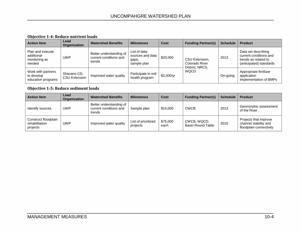
UNCOMPAHGRE WATERSHED PLAN
MANAGEMENT MEASURES 10-4
Objective 1-4: Reduce nutrient loads
Action Item Lead Organization
Watershed Benefits Milestones Cost Funding Partner(s) Schedule Product
Plan and execute additional monitoring as needed
UWP Better understanding of current conditions and trends
List of data sources and data gaps, sample plan
$20,000 CSU Extension, Colorado River District, NRCS, WQCD
2013
Data set describing current conditions and trends as related to (anticipated) standards
Work with partners to develop education programs
Shavano CD, CSU Extension
Improved water quality Participate in soil health program
$2,000/yr On-going Appropriate fertilizer application Implementation of BMPs
Objective 1-5: Reduce sediment loads
Action Item Lead Organization
Watershed Benefits Milestones Cost Funding Partner(s) Schedule Product
Identify sources UWP Better understanding of current conditions and trends
Sample plan $15,000 CWCB 2013 Geomorphic assessment of the River
Construct floodplain rehabilitation projects
UWP Improved water quality List of prioritized projects
$75,000 each
CWCB, WQCD, Basin Round Table
2015 Projects that improve channel stability and floodplain connectivity

UNCOMPAHGRE WATERSHED PLAN
MANAGEMENT MEASURES 10-5
Goal 2): Improve riverine ecosystem function
Objective 2-1: Understand the factors that lead to instability and unpredictability of the river channel
Action Item Lead Organization
Watershed Benefits Milestones Cost Funding Partner(s) Schedule Product
Watershed Assessments
UWP Better understanding of current conditions and trends
Conduct watershed assessments
$200 Local businesses Yearly Data on riparian zone and channel conditions
Channel monitoring UWP Better understanding of current conditions and trends
Sample Plan $10,000 CWCB, WQCD 2015 Precise data on changes in the channel
Watershed mapping UWP Better understanding of current conditions and trends
Sample Plan $5,000 CWCB, WQCD, Private foundations
2015 Visual image of instable areas
Objective 2-2: Protect environmentally sensitive areas
Action Item Lead Organization
Watershed Benefits Milestones Cost Funding Partner(s) Schedule Product
Education UWP Long term preservation of the Uncompahgre River’s unique environments
Education Forums, updates on website
$1,000/yr Membership On-going Education materials Maps
Encourage conservation through easements
BCRLT Meetings with BCRLT
Varies by property
DPW, GOCO On-going Forums with Land Trusts
Remove weeds and non-native species
UWP
Improved habitat Improved flood protection Water quality improvements
Write grants to implement Tamarisk Coalition plans
$22,000/mi Colorado River District, Tamarisk Coalition, CWCB
2012 (start)
Healthy native riparian communities

UNCOMPAHGRE WATERSHED PLAN
MANAGEMENT MEASURES 10-6
Objective 2-3: Improve flood management within the Uncompahgre Valley
Action Item Lead Organization
Watershed Benefits Milestones Cost Funding Partner(s) Schedule Product
Revise floodplain mapping
FEMA Responsible development
Conduct floodplain surveys
unknown FEMA 2014 Current floodplain maps
Reform land use regulations in the floodplain
Counties, FORU
Better protection from floods Improved habitat
Meetings with local governments
$2,000/yr Counties, Municipalities
On-going Land use regulations that limit development in the floodplain
Education UWP Awareness of responsibility when building in floodplain
Education Forums, updates on website
$1,000/yr FEMA, Counties On-going Education materials Maps
Rehabilitate floodplain
UWP Improved water quality List of prioritized projects
$75,000 each
CWCB, WQCD, Basin Round Table
2015 Projects that improve channel stability and floodplain connectivity
Objective 2-4: Encourage development of riparian buffers and wetlands
Action Item Lead Organization
Watershed Benefits Milestones Cost Funding Partner(s) Schedule Product
Education UWP Long term preservation of the Uncompahgre River’s unique environments
Education Forums, updates on website
$1,000/yr Membership On-going Education materials Maps
Promote conservation easements
BCRLT Meetings with BCRLT
Varies by property
DPW, GOCO On-going Forums with Land Trusts
Remove weeds and non-native species
UWP
Improved habitat Improved flood protection Water quality improvements
Write grants to implement Tamarisk Coalition plans
$22,000/mi Colorado River District, Tamarisk Coalition, CWCB
2012 (start)
Healthy native riparian communities

UNCOMPAHGRE WATERSHED PLAN
MANAGEMENT MEASURES 10-7
Objective 2-4: Improve in-stream habitat structure
Action Item Lead Organization
Watershed Benefits Milestones Cost Funding Partner(s) Schedule Product
Install in-stream habitat structures
UWP Increased in-stream habitat diversity
Design plans $50,000-$250,000/ project
DPW, CWCB 2015 fish refugia
Planting of riparian vegetation
UWP
Structural diversity, shade cover, nutrient inputs, large woody recruitments, bank stabilization
Improved scores in Rapid River Assessments
$10,000/mi Colorado River District, CWCB, NRCS, Counties
2013 over-hanging vegetation
Bank stabilization UWP Reduced sediment and erosion, increased habitat
Design plans 50,000-$250,000/ project
DPW, CWCB 2015 Stable banks
Goal 3) Improve seasonal low flows
Objective 3-1: Identify long-term strategies to augment flows
Action Item Lead Organization
Watershed Benefits Milestones Cost Funding Partner(s) Schedule Product
Coordinate with water users and water managers on conservation strategies
Wise Water Use Council
Increased in-stream flows, cooler water temperatures, improved aquatic habitat, increased recreation potential
Participate in Wise Water Use Council
$1.000/yr Colorado River District, BOR, CWCB
On-going Plan to improve seasonal low flows

UNCOMPAHGRE WATERSHED PLAN
MANAGEMENT MEASURES 10-8
Goal 4) Improve recreation opportunities
Objective 4-1: Educate the public about rights, responsibilities and safety hazards
Action Item Lead Organization
Watershed Benefits Milestones Cost Funding Partner(s) Schedule Product
Develop educational materials
UWP Increased public awareness
Develop signs and maps
$5,000 CWCB, Colorado River District, Outfitters
On-going Maps and signage available to the public
Re-engineer dangerous diversions
UVWUA, Ditch Companies
Increased safety Prioritized list of diversion structures
$100,000/ea CWCB, Round Table
On-going Safe diversion structures
Goal 5) Create a stable stakeholder group
Objective 5-1: Increase participation in UWP
Action Item Lead Organization
Watershed Benefits Milestones Cost Funding Partner(s) Schedule Product
Increase stakeholder involvement by 5 new organizations
UWP/ROCC Increased awareness Develop materials about the UWP
No cost n/a 2012 New partners
***Create regular volunteer activities
UWP Community ownership in the UWP
List of volunteer opportunities
$500/yr Local businesses 2012 New volunteers
***Schedule regular UWP meetings
UWP Consistency Set meeting schedule
$500/yr Local businesses 2012 Consistent communication
***Formalize group structure
UWP/ROCC Community understating of the UWP
Develop mission/vision statements Develop by-laws
$1,000 Local businesses, private foundations
2012 Decision making structure File for nonprofit status

UNCOMPAHGRE WATERSHED PLAN
MANAGEMENT MEASURES 10-9
Objective 5-2: Secure funding for implementation
Action Item Lead Organization
Watershed Benefits Milestones Cost Funding Partner(s) Schedule Product
***Apply for grants UWP Project money Grant calendar $5,000/yr Private Foundations, agencies
On-going Grant funding to start implementation
Establish membership
UWP Stable funding stream Membership rate structure
$5,000 Local Businesses 2012 General operating funds
UNCOMPAHGRE WATERSHED PLAN
MANAGEMENT MEASURES 10-10
10.2 Partner Efforts
To achieve many of the goals identified in Section 9, the UWP will need to work in close collaboration with partner agencies, districts and coalitions. In most instances, the UWP will serve in a support role while other partners take the lead role coordinating restoration activities. Many of the goals, objectives, action items, indicators, cost estimates and schedules listed in the action plans (Section 9) are dependent on recommendations of reports scheduled for completion in the near future (Table 10.1).
10.3 Load Reductions
The EPA requires watershed plans to estimate the load reductions expected from management measures. Load reductions are based on the cause-and-effect relationship between pollutant loads and the waterbody response. Establishing this link allows evaluation of how much load reduction from watershed sources is needed to meet waterbody targets. Many of the objectives identified in Section 9 entail additional data collection efforts in order to better characterize and understand the source and scale of watershed impairments. The UWP was unable to calculate pollutant loads (i.e. salt and sediment). Table 10.2 and 10.3 summarize the known current and target load reductions for metals and selenium as identified on the TMDLs. Expected load reductions in pollutants will be determined for future projects addressing water quality impairments from pollutant loading.

UNCOMPAHGRE WATERSHED PLAN
MONITORING STRATEGIES 11-1
11.0 MONITORING STRATEGY The Uncompahgre Watershed Partnership (UWP) commissioned two river assessments as part of the watershed planning effort. The Uncompahgre River Water Quality Report summarized water quality. The Uncompahgre River Rapid River Assessment assessed the physical condition of the river corridor. Both studies evaluated the Uncompahgre River from a point above the confluence with Red Mountain Creek to the mouth in Delta. Table 11.1 summarizes the monitoring recommendations for the Uncompahgre Watershed.
Notes: a) Future assessments should refine methods to be repeatable, increase accuracy and precision among data collectors, and require more field measurements. Consider seasonal variation. Collect water quality data (pH, DO, metal loading, discharge) at with field data. Include a station between KOA and Ridgway.
b) Very little biological data exists for the Uncompahgre River above Red Mountain Creek.
c) This program should include a sampling site at the mouth of Red Mountain Creek. Sampling by Newmont Mining should also be expanded to include additional parameters such as hardness, dissolved cadmium, copper, lead, aluminum and iron. The current sampling program as agreed to by the State of Colorado and Newmont Mining results only in the analysis of zinc. However, copper, aluminum, and iron contribute more to the toxicity of Red Mountain Creek than zinc. More information is needed for cadmium, copper, lead, aluminum, and iron to better understand the contamination in Red Mountain Creek and define improvements needed to define appropriate restoration strategies for Red Mountain Creek.
Table 11.1 Watershed Monitoring Recommendations
Type Location Frequency Purpose
Rapid River Assessment
a
Entire River Annual Baseline data
Macro -invertebrates
Entire Riverb Annual Baseline data
Fish Survey Entire Riverb Every 5 yrs Baseline data
Metals Red Mountain Creek c
Monthly Characterization of all metals
Metals and sediment
Uncompahgre River above and below Ouray Hydrodam
d
Seasonal flushing events
Document influence of Ouray Hydrodam
Uncompahgre River from Ouray to Ridgway
e Storm events Document impact of summer storm events
Substrate Uncompahgre River from Ouray to Ridgway
f Fall and winter Determine sediment source
Temperature Above and below LaSalle Road
g
Daily Determine appropriate temperature standard based on ambient temperature data
Nutrient loading study
Lower basin tributariesh 1 year study Characterize nutrient loads
Source: Lower Gunnison Basin TMDL (WQCD, 2010)

UNCOMPAHGRE WATERSHED PLAN
MONITORING STRATEGIES 11-2
d) The influence of the flushing operations at the Ouray Hydropower Station on the metals regime of the Uncompahgre River requires further examination. A series of samples should to be analyzed for dissolved and total metals during two of the upcoming flushing operations. Each sample should be analyzed for calcium, cadmium, copper, iron, lead, magnesium, zinc, pH and suspended solids to allow for a determination of the toxic impacts of the flushing operation in the Uncompahgre River from Ouray to Ridgway Reservoir.
e) The influence of episodic metal loadings associated with summer storm events needs to be quantified in the Uncompahgre River in the stream reach extending from Ouray to Ridgway. This sample program would include collection of samples during and after storm events. Multiple sites should be established to evaluate metals loads from major tributaries.
f) A fall and winter stream substrate sampling program is needed in the mainstem Uncompahgre River from Ouray to Ridgway to determine the source of fine sediments that may be limiting aquatic macroinvertebrates and fish populations in that stream reach.
g) Temperatures regimes need to be clarified for the Uncompahgre River in Montrose to assure that temperature standards and the aquatic life classification for this stream reach protect the existing aquatic assemblage. Temperature loggers should be installed upstream and downstream of La Salle Road
h) Nitrogen and phosphorus levels introduced to the mainstem Uncompahgre River from these tributaries are much higher than in most western Colorado streams and rivers. A sampling program designed to better understand the influence of confined feedlots on nutrient loadings to the Uncompahgre Basin would allow for design of appropriate control measures. The influence of confined feedlot operations needs to be determined in the Uncompahgre River from Montrose to Delta including tributaries such as Dry Cedar Creek, Cedar Creek, Loutsenhizer Arroyo and Dry Creek. Waters fro m these four tributaries, especially The Loutsenhizer Arroyo, degrade the water quality of the mainstem Uncompahgre River.
Existing Water Quality Monitoring Stations All water quality data used in the development of the Uncompahgre Watershed Plan and Uncompahgre Water Quality Report were obtained from existing data sets (Table 11.1). Data was collected from state agencies, EPA, commissioned special studies, and River Watch (Figure 11.1). Few of these sites have been sampled for an extended period of time, despite the importance of water quality to the economy of the Uncompahgre Valley. It is critically important that WQCD and River Watch volunteers continue monitoring water quality data in the Uncompahgre River, especially as they relate to metals.

UNCOMPAHGRE WATERSHED PLAN
EDUCATION AND OUTREACH 12-1
12.0 EDUCATION AND OUTREACH
The long term ecological health of the Uncompahgre Watershed depends on the values and actions of current and future generations. Informing the public from the residents, recreational users, tourists, local officials, and resource managers of the Uncompahgre watershed about how their actions affect water quality is a high priority of the UWP. Increasing awareness and, ultimately, changes in behavior are our long term strategy for restoring and protecting water quality.
In order to connect with Ouray, Montrose, and Delta Counties, the UWP has developed a working strategy. The goals of this stratagem consists of building a sense of not only understanding of conservation and stewardship as it relates to water quality and our rivers but also educating the community on the historic mining that is a part of the local heritage and how it affected the origin of the communities in these counties.
To build support for the UWP’s efforts the creation of partnerships with other community organizations, non-profits, governmental agencies, and interest groups is important. The UWP wants as much community input and support as possible with its education and outreach objectives. Through these partnerships a greater amount of awareness and immersion into the community is created.
12.1 Education Goals
Working toward the restoration of the Uncompahgre Watershed by making it into a healthy and sustainable resource through community involvement and responsible use is the main goal of the UWP. Community education that is based on interacting with and being on the river can help foster a sense of ownership within community members. With that sense of ownership a great deal can be achieved toward the improvement and health of the river and this watershed.
Degradation can place a substantial burden on a community and all of its members stand to lose something as a result. Through the outreach strategy of the UWP, a clear understanding of our relationship to the river and what our role should be to make this watershed healthy and beneficial toward socioeconomic interests will be created. The UWP will be a source for watershed-related information for the public.
12.2 Outreach Activities
The UWP has held several outings and participated in events to work toward the public understanding stated above in the Education Goals;
Bi-monthly UWP stakeholder meetings (2007 and onward)
Meetings have presentations from experts on water quality issues as well as
community input on what current conditions are in the watershed. The meetings
create cooperation and collaboration.
Abandoned Mines and Water Qualtiy Conference (April 2011 and to become annual)
The conference brought together government officials, water quality experts, and
other watershed groups within the region to talk, collaborate, and brainstorm on
BMPs, mining issues, water quality, and the future of our watershed.
Annual Mine Tour

UNCOMPAHGRE WATERSHED PLAN
TABLES
12-2
The mine tour brings citizens and stakeholders out in the field to see first- hand the
historical value of mining and its contribution to the settlement and economy of the
area as well as the current watershed issues that are related.
Rapid River Assessment on the Uncompahgre River (volunteer event to become
annual)
The river assessments bring citizens and stakeholders out to evaluate the current
conditions of riparian areas and water quality based on state protocol. It creates
awareness and leads to a more involved and informed community.
Educational Forums
The UWP has held educational events from 2 mining workshops to events concerning
wildlife, storm-water, recreation, and agriculture. The purpose of these forums was to
bring experts, decision makers, and the public together to learn about watershed
issues and to better inform the public on various types of land use and their effect on
water quality and the different BMPs that could address these issues.
Postings on: http://uncompahgrewatershed.org/
Our website keeps people up to date of what is going on in the watershed and what the
UWP has been working on.
Watershed Pollution model demonstrations at the Ridgway River Festival and the
State Park’s Lake Appreciation Day. (Annual)
The UWP presence at these events not only puts our name out there in the community
but it creates awareness about watershed issues as well in a fun educational
environment.
Newspaper Articles
Presence in the press creates awareness of the UWP and helps build community
support.
With the completion of this Watershed Plan the UWP will be able to devote more resources to the development and implementation of the further outreach activities.
12.3 Target Audiences
In order to achieve the education and outreach goals it is necessary to identify key groups whose support and action will lead to the most progress possible in the watershed. The target audiences are prioritized based on impact of the audience as well as the audiences’ relative influence in the community. The UWP wishes the community to make “watershed friendly” decisions and therefore wishes to provide all the tools and guidance necessary to make informed and conscious decisions that concern our watershed and its successful management. The key audiences for the Uncompahgre River watershed are:
Legacy Miners
There is a population of miners living in Ouray County who were part of the mining efforts that took place in the region historically. They still hold an interest in mining’s future in the area and would like to see it be a part of the economy in years to come. This interest has been put on hold due to the heavy metal impairments on the Uncompahgre River and Red Mountain Creek. Their interests depend on the meeting of the TMDL and compliance with state regulations for discharge.
EDUCATION AND OUTREACH

UNCOMPAHGRE WATERSHED PLAN
TABLES
13-3
Riverfront Landowners
These people, in that their property borders the river, are most susceptible to the unhealthy changes in the watershed. Property value is directly affected by the health and use of the river. Pollution, riparian zone degradation, and bank erosion all pose threats to their property and prosperity.
Farmer/ Ranchers
These people are the irrigators. Approximately 86% of consumptive use water in Colorado goes toward agriculture. Their importance for both the economy and as a food source is undeniable, yet some ditches can lead to sedimentation and deep percolation that has potential adverse affects on riparian and aquatic life. There are BMPs to mitigate these issues.
Industry
The inactive mines along with the active gravel mining in the county contribute to watershed contamination and degradation, which is a concern for many citizens. In searching for BMPs for these interests it is important to have effective monitoring and other protective procedures to ensure the health of the watershed. The UWP encourages effective and practical environmental considerations and solutions for these issues.
Recreational Users
From fisherman and boaters to visiting tourists in the watershed there is a chance for degradation to take place. It is important to encourage a sense of stewardship and respect for our natural spaces and properties along the river corridor to ensure that recreation has no adverse affects. Riparian and aquatic habitat preservation does depend on responsible use and interaction with the river.
Locally elected officials and municipal employees
As decision makers, it is important for these people to have a comprehensive understanding of community watershed management, including issues at stake and the competing viewpoints involved. Also, many grants to improve watersheds must be attained through the town governments, as opposed to watershed organizations. Informed leaders allow for better decisions to have a long-lasting positive effect on the watershed.
Citizens/ Stakeholders
The river water is used to grow food and drinking water comes from various springs and systems within the watershed. As a result all people living in the watershed, or recreating on it, will depend on its health to some degree. Much of the area’s business and employment, such as outfitters and guide services and even shops and restaurants, depend on the area’s natural beauty and environmental health. That is what brings tourism here.
12.4 Outreach Strategies
Table 12.1 identifies the target audiences by watershed issue and the specific messages and outreach methods of the UWP.
13.0
EDUCATION AND OUTREACH 12-3

UNCOMPAHGRE WATERSHED PLAN
EVALUATION OF IMPLEMENTATION STRATEGIES 13-1
13.0 EVALUATION OF IMPLEMENTATION STRATEGIES
While the Uncompahgre Watershed Plan is intended to restore and protect the Uncompahgre Watershed, it is important to periodically evaluate the implementation efforts to determine: 1) whether the project is on track and the tasks are implemented in a timely manner, and 2) whether the projects are successful in restoring and protecting water resources and that funds are spent wisely.
The purpose of the Uncompahgre Watershed Plan is to improve or restore conditions in the Uncompahgre Watershed in a manner that is compatible with the local economy, private property rights, and regulatory water quality compliance. In order to evaluate the effectiveness of implementation measures over time, we will compare the results of watershed monitoring efforts as they are repeated. Table 13.1 lists methods for the UWP to evaluate successful implementation of the watershed plan and ultimately the health of the Uncompahgre Watershed.

UNCOMPAHGRE WATERSHED PLAN
WORKS CITED 14-1
14.0 WORKS CITED Apodaca, L.E., Stephens, V.C. and Driver, N.E. 1996. "What Affects Water Quality in the Upper Colorado River Basin?" USGS Fact Sheet FS-109-96, 4 p.
BBC Research and Consulting. 2008. The Economic Impacts of Hunting, Fishing and Wildlife Watching in Colorado. Prepared for Colorado Division of Wildlife.
Berry, Michael. 11/19/2009. Manager, Tri-County Water Conservancy District. Personal Communication.
BLM (Bureau of Land Management). 2009. Draft Wild and Scenic River Eligibility Report for the BLM Uncompahgre Planning Area.
Burnell, James R. Carroll, Christopher. Young, Genevieve, 2008. Colorado Mineral and Industry Activities, 2007. Colorado Geological Survey.
CDM. 2004. Statewide Water Supply Initiative report. Prepared for Colorado Water Conservation Board. http://cwcb.state.co.us/IWMD/SWSITechnicalResources/SWSIPhaseIReport/
CDM. 2007. Statewide Water Supply Initiative report – Phase 2. Prepared for Colorado Water Conservation Board. http://cwcb.state.co.us/IWMD/SWSITechnicalResources/SWSIPhaseIIReport/.
CDM. 2004a. Statewide Water Supply Initiative report. Chapter 1: Introduction. Prepared for Colorado Water Conservation Board. http://cwcb.state.co.us/IWMD/PhaseIReport.htm.
CDM. 2004b. Statewide Water Supply Initiative report. Appendix E: Statewide M&I and SSI Water Demand Projections. Prepared for Colorado Water Conservation Board. http://cwcb.state.co.us/IWMD/PhaseIReport.htm.
CDM. 2004c. Statewide Water Supply Initiative report. Chapter 5: Projected Water Use. Prepared for Colorado Water Conservation Board. http://cwcb.state.co.us/IWMD/PhaseIReport.htm.
CDM. 2004d. Statewide Water Supply Initiative report. Chapter 6: Water Needs Assessment. Prepared for Colorado Water Conservation Board. http://cwcb.state.co.us/IWMD/PhaseIReport.htm.
CDM. 2009. Nonconsumptive Needs Assessment Focus Mapping. Gunnison Basin Mapping Results: Appendix D-3. Prepared for Colorado Water Conservation Board. http://cwcb.state.co.us/IWMD/COsWaterSupplyFuture/CosWaterSupplyFuture.htm
CDSS (Colorado Decision Support System). 2008. Stream Flow Data Selector Version 1.8.19.1 http://cdss.state.co.us/DNN/ViewData/StationsStreamflow/tabid/74/Default.aspx
CDSS (Colorado Decision Support System). 2008. CDSS Water Rights Data Selector Version 1.09.12.32 http://cdss.state.co.us/DNN/WaterRights/tabid/76/Default.aspx
Corona Research, Colorado State Parks Marketing Assessment, “Visitor Spending Analysis 2008-2009.”
CGS [Colorado Geological Survey]. 2003. Ground Water Atlas of Colorado. CGS Special Publication 53.
CFWE (Colorado Foundation for Water Education), 2004. Citizens Guide to Colorado Water Law, 2nd Ed.
CWCB (Colorado Water Conservation Board). 2004. Drought and Water Supply Assessment. http://cwcb.state.co.us/Conservation/RelatedInformation/Publications/ColoradoDroughtWaterSupplyAssessmentDWSA/CWCBDroughtWaterSupplyAssessment.htm
CWCB (Colorado Water Conservation Board). Accessed 11/2009. Instream Flow and Natural Lake Level Water Rights Database. http://cwcb.state.co.us/StreamAndLake/RelatedInformation/ToolsResources/InstreamFlowNaturalLakeLevelWaterRightsDB/InstreamFlowNaturalLakeLevelWaterRightsDB.htm
UNCOMPAHGRE WATERSHED PLAN
TABLES
14-2
CWCB (Colorado Water Conservation Board). 2009. Colorado River Decision Support System 2005 Irrigated Parcels. div4_irrig_2005.
CWCB (Colorado Water Conservation Board). No Date. Gunnison River Drought & Water Supply Assessment Basin Summary. http://cwcb.state.co.us/Conservation/DroughtPlanning/DroughtWaterSupplyAssessment/
Colorado State Parks. 2008. Fiscal Year 07-08 Park Facts: Ridgway State Park
Colorado State Parks. 2008. Fiscal Year 07-08 Park Facts: Sweitzer Lake State Park
Colorado Department of Revenue, 2009. Sales Tax Statistical Summary, January to December 2008. http://www.colorado.gov/cs/Satellite?blobcol=urldata&blobheader=application%2Fpdf&blobkey=id&blobtable=MungoBlobs&blobwhere=1239161289021&ssbinary=true
Colorado Division of Reclamation and Mining Safety, 2010. Mining Operations Report. http://mining.state.co.us/operatordb/criteria.asp?search=
Colorado Water Quality Control Commission. 2010. 5 CCR 1002-93, REGULATION #93.
COLORADO'S SECTION 303(D) LIST OF IMPAIRED WATERS AND MONITORING AND EVALUATION LIST. Denver, Colorado.
Davis,William Y., William Christiansen, Sean Blacklocke, Joseph Berlin. 2004. SWSI Water Demand Forecast. Technical Memorandum 2.3. CDM. Prepared for CWCB
DOLA (Department of Local Affairs). 2001. The Colorado Drought Mitigation and Response Plan. http://cwcb.state.co.us/Conservation/DroughtPlanning/ColoradoDroughtMitigationResponsePlan/
DWR (CO Division of Water Resources) 2008. Cumulative Yearly Statistics. http://water.state.co.us/pubs/cummulrpt.asp
DOLA [Department of Local Affairs]. 2009. County Level Population Forecasts. http://dola.colorado.gov/dlg/demog/pop_totals.html
DOLA [Department of Local Affairs]. 2009. Colorado Jobs by Sector NAICS based. http://dola.colorado.gov/dlg/demog/pop_totals.html
Flood Insurance Study: Delta County, Colorado Unincorporated Areas. Federal Emergency Management Agency. 1991.
Fosha, Hyre. 1995a. Colorado River Decision Support System Task Memorandum 1.15-19: Water Rights Planning Model, Bostwick Park Project - Cimarron River Water Rights
Fosha, Hyre. 1995b. Colorado River Decision Support System Task Memorandum 1.15-20: Water Rights Planning Model, Dallas Creek Project (Ridgway Reservoir) - Project 7 Water Authority
Fosha, Hyre. 1995c. Colorado River Decision Support System Task Memorandum 1.15-21: Water Rights Planning Model, Operations of Taylor Park and Blue Mesa Reservoirs
Fosha, Hyre. 1995d. Colorado River Decision Support System Task Memorandum 1.15-25: Water Rights Planning Model, Uncompahgre Project
Frizell, Kathleen H. an Heibert, Steven D. 2004. Dissolved Gas and Fishery Investigations at Ridgway Dam – Phases 1, 2 and 3 Report. US Department of Interior, Bureau of Reclamation.
Henz, John; Turner, Seth; Bardini, William; Kenny, Jerry. 2004 Chapter One, Historical Perspectives on Colorado Drought. http://cwcb.state.co.us/Conservation/RelatedInformation/Publications/ColoradoDroughtWaterSupplyAssessmentDWSA/
Hooper, D.R. 1973. Evaluation of the effects of flows on trout stream ecology. Dept. Engineering Research Pacific Gas and Electric Co., Emeryville, CA. 97pp.
WORKS CITED

UNCOMPAHGRE WATERSHED PLAN
TABLES
14-3
Hutson, S.S., Barber, N.L., Kenny, J.F., Linsey, K.S., Lumia, D.S., and Maupin, M.A., 2004. Estimated Use of Water in the United States in 2000: U.S. Geological Survey Circular 1268, 52 p. http://pubs.usgs.gov/circ/2004/circ1268/
Jacobson, Eric. 2009. Order Issuing Subsequent License. 128 FERC 62,159.
Johnson, R. R., L. T. Haight, and J. M. Simpson. 1977. Endangered species vs. endangered habitats: A concept. Pages 68-74 in Importance, preservation, and management of riparian habitat: A symposium (proceedings). R. R. Johnson and D. A. Jones (tech coords.), July 9, Tucson, AZ. General Technical Report RM-43, Fort Collins, CO. USDA Forest Service, Rocky Mountain Forest and Range Experiment Station. 217 pp.
Johnson, S. 2002 . Use Attainability Analysis, Aquatic Life Use – Idarado NRD Site. Colorado Department of Public Health and the Environment, Water Quality Control Division. Denver, Colorado.
Kenny, J.F., Barber, N.L., Hutson, S.S., Linsey, K.S., Lovelace, J.K., and Maupin, M.A., 2009, Estimated use of water in the United States in 2005: U.S. Geological Survey Circular 1344, 52 p. http://pubs.usgs.gov/circ/1344/
Krueper, D. J. 1993. Effects of land use practices on Western riparian ecosystems. Pages 321-330 in Status and management of Neotropical migratory birds, D. M. Finch and P. W. Stangel (Eds). Gen. Tech. Rep. RM-229, Fort Collins, CO. USDA Forest Service, Rocky Mountain Forest and Range Experiment Station. 422 pp.v
Krueper, D. J. 1996. Effects of livestock management on Southwestern riparian ecosystems. Pages 281-301. in Desired future conditions for Southwestern riparian ecosystems: Bringing interests and concerns together. D. W. Shaw and D. M. Finch (tech coords.). Sept 18-22, 1995; Albuquerque, NM. Gen. Tech. Rep. RM-GTR-272. Fort Collins, CO. USDA Forest Service, Rocky Mountain Forest and Range Experiment Station. 359 pp.
Kuhn, Eric. 2007. The Colorado River: The Story of a Quest for Certainty on a Diminishing River. Round Table Edition.
Mussetter R.A. and Harvey, M.D. 2001. The Effects of Flow Augmentation on Channel Geometry of the Uncompahgre River. Applying Geomorphology to Environmental Management. Water Resources Publications, LLC. p 177-200.
Pathfinder Project. Accessed 12/2009. http://www.gmugpathfinder.org/
Przeszlowska, A, Sauter, S., Boothby, R., and Jurjonas, M. 2012. Rapid River Assessment of the Uncompahgre River. Produced for the Uncompahgre Watershed Partnership.
Price, C. 2008. Idarado Mine remediation measure of success. Report released by Colorado Department of Public Health and the Environment, Hazardous Materials and Waste Management Division. Denver, Colorado.
Reich, Denis. 2009. Profit Opportunities with Irrigation Technology. Power Point Presentation at the Uncompahgre Agriculture Forum. 12/3/2009.
Region 10 League for Economic Assistance and Planning, Inc. 2009. Region 10 Communities. http://www.region10.net/about/about_region10.htm
Runkel, R.L., Kimball, B.A., Walton-Day, K. and Verplank, P.L. 2005. Geochemistry of Red Mountain Creek, Colorado, under low-flow conditions, August 2002. Scientific Investigations report 2005-5101. USGS. Reston Virginia.
Runkel, R.L., Kimball, B.A., Walton-Day, K. and Verplank, P.L. 2007. A simulation based approach for estimating premining water quality: Red Mountain Creek, Colorado. Applied Geochemistry. 22:1899-1918.
Schupbach, S. A. 1996. Colorado River Decision Support System 1993 Irrigated Parcels. div4_irrig_1993, Ed 3. 0
WORKS CITED

UNCOMPAHGRE WATERSHED PLAN
TABLES
14-4
Solley, W.B., Merk, C.F., and Pierce, R.R. 1988. Estimated Use of Water in the United States in 1985: U.S. Geological Survey Circular 1004. http://pubs.er.usgs.gov/usgspubs/cir/cir1004
Solley, W.B., Pierce, R.R., and Perlman, H.A. 1993. Estimated Use of Water in the United States in 1990: U.S. Geological Survey Circular 1081. http://water.usgs.gov/watuse/wucircular2.html
Solley, W.B., Pierce, R.R., and Perlman, H.A. 1998. Estimated Use of Water in the United States in 1995: U.S. Geological Survey Circular 1200, 79 p. http://water.usgs.gov/watuse/pdf1995/html/
Theobald, D.M., G. Wilcox, S.E. Linn, N. Peterson, and M. Lineal. 2008. Colorado Ownership, Management, and Protection v7 database. Human Dimensions of Natural Resources and Natural Resource Ecology Lab, Colorado State University, Fort Collins, CO. 15 September. www.nrel.colostate.edu/projects/comap
Techni Graphic Systems, Inc. 2004. Colorado River Decision Support System 2000 Irrigated Parcels. div4_irrig_2000
The Watch. 12/17/2009. Stimulus Money to Fund Ouray Micro-Hydro Project.
TNC (The Nature Conservancy). 2009. Freshwater Conservation: Changing Water Policies to Protect Environmental Flows. Accessed 12/14/2009. (http://www.nature.org/initiatives/freshwater/strategies/flows.html).
USFS (US Forest Service). 2007. Proposed Land Management Plan, Grand Mesa, Uncompahgre, and Gunnison National Forests. http://www.fs.fed.us/r2/gmug/policy/plan_rev/proposed/index.shtml
USBR. 2003. Providing Fish Screening in the Redlands Power Canal. Draft Environmental Assessment for. pp 9-12. http://www.usbr.gov/uc/wcao/envprog/pdfs/RedlandsFS-dea.pdf
USBR. 2009a. Bostwick Park Project. Updated April, 2009. http://www.usbr.gov/projects/Project.jsp?proj_Name=Bostwick+Park+Project
USBR. 2009b. Dallas Creek Project. Updated October, 2009. http://www.usbr.gov/projects/Project.jsp?proj_Name=Dallas+Creek+Project
USBR. 2009c. Uncompahgre Project. Updated May, 2009. http://www.usbr.gov/projects/Project.jsp?proj_Name=Uncompahgre+Project
USBR, 2009d. Glen Canyon Dam/Lake Powell. Updated November, 2009. http://www.usbr.gov/uc/water/crsp/cs/gcd.html
USBR. 2007. Colorado River interim guidelines for Lower Basin shortages and coordinated operations for Lakes Powell and Mead, Draft Environmental Impact Statement, February 2007. http://www.usbr.gov/lc/region/programs/strategies/draftEIS/index.html.
USCD [US Department of Commerce]. Bureau of Economic Analysis. 2009. Regional Economic Accounts/ Local Area Personal Income. http://www.bea.gov/regional/reis/
USDA [US Department of Agriculture]. 2009. Economic Research Service. County-Level Unemployment and Median Household Income for Colorado. http://www.ers.usda.gov/Data/Unemployment/RDList2.asp?ST=CO
USDA [U.S. Department of Agriculture]. 2009. National Agricultural Statistics Service. Census of Agriculture. Colorado State and County Data, Volume 1, Geographic Area Series, Part 6
http://www.agcensus.usda.gov/Publications/2007/Full_Report/Volume_1,_Chapter_1_State_Level/Colorado/index.asp
WQCD, 2009. Total Maximum Daily Load Assessment Red Mountain Creek/Uncompahgre River, San Juan/Ouray/Montrose County, Colorado. Final Draft.
WQCD, 2009. Total Maximum Daily Load Assessment Gunnison River and Tributaries Uncompahgre River and Tributaries, Delta/Mesa/Montrose Counties, Colorado. Public Notice Draft.
WQCD, 2009. Use Attainability analysis Uncompahgre River.
WORKS CITED

UNCOMPAHGRE WATERSHED PLAN
TABLES
14-5
White, Jonathan L., TC Wait, and Matthew L. Morgan. 2008, Geologic Hazards Mapping Project for Montrose County, Colorado. Colorado Geological Survey, Denver, CO.
Woodbury, Dale. Personal Communication, June 8, 2009. District Conservationist. NRCS.
Woodling, et. al. 2010. Uncompahgre River Water Quality Report. Produced for the Uncompahgre Watershed Partnership.
WORKS CITED

UNCOMPAHGRE WATERSHED PLAN
TABLES 15-1
15.0 TABLES
Table 2.1. Counties in the Uncompahgre Watershed
County Acres Acres in
Watershed % of county in
Watershed % of Watershed
in County
Delta 735,674 15,636 2.1% 2.2%
Gunnison 2,065,945 24 0.001% 0.003%
Hinsdale 719,387 44 0.006% 0.006%
Montrose 1,437,265 347,472 24.2% 48.7%
Ouray 347,274 345,664 99.5% 48.4%
San Juan 249,413 4,825 1.9% 0.7%
San Miguel 826,078 211 0.026% 0.030%
Total 713,876
Source: NRCS Rapid Watershed Assessment, 2009
Table 2.2. Historical Climate Data
Station Name
Growing Season (days)*
Avg. Minimum Temperature
(F)
Avg. Maximum Temperature
(F)
Avg. Total
Precip. (in)
Avg Total Snowfall
(in) Jan July Jan July
Delta 142 12.2 54.8 38.7 93.1 8.01 15.2
Montrose 2 155 13.6 55.7 37.9 88.6 9.53 25.8
Ridgway n/a 4.9 45.0 39.5 82.9 17.09 83.6
Ouray 119 14.9 51.1 36.8 78.3 23.05 140.1
* Freeze free period defined by 90% probability of day above 28F
Source: Western Regional Climate Center http://www.wrcc.dri.edu/ and http://www.wcc.nrcs.usda.gov/climate/
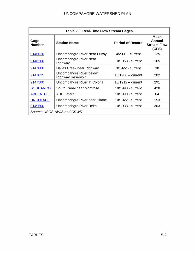
UNCOMPAHGRE WATERSHED PLAN
TABLES
15-2
Table 2.3. Real-Time Flow Stream Gages
Gage Number
Station Name Period of Record
Mean Annual
Stream Flow (CFS)
9146020 Uncompahgre River Near Ouray 4/2001 - current 125
9146200 Uncompahgre River Near Ridgway
10/1958 - current 165
9147000 Dallas Creek near Ridgway 3/1922 - current 38
9147025 Uncompahgre River below Ridgway Reservoir
10/1988 – current 202
9147500 Uncompahgre River at Colona 10/1912 – current 291
SOUCANCO South Canal near Montrose 10/1990 - current 420
ABCLATCO ABC Lateral 10/1990 - current 64
UNCOLACO Uncompahgre River near Olathe 10/1922 - current 153
9149500 Uncompahgre River Delta 10/1938 - current 303
Source: USGS NWIS and CDWR
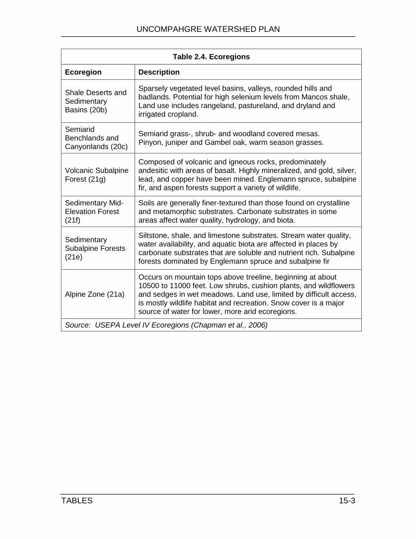
UNCOMPAHGRE WATERSHED PLAN
TABLES
15-3
Table 2.4. Ecoregions
Ecoregion Description
Shale Deserts and Sedimentary Basins (20b)
Sparsely vegetated level basins, valleys, rounded hills and badlands. Potential for high selenium levels from Mancos shale, Land use includes rangeland, pastureland, and dryland and irrigated cropland.
Semiarid Benchlands and Canyonlands (20c)
Semiarid grass-, shrub- and woodland covered mesas. Pinyon, juniper and Gambel oak, warm season grasses.
Volcanic Subalpine Forest (21g)
Composed of volcanic and igneous rocks, predominately andesitic with areas of basalt. Highly mineralized, and gold, silver, lead, and copper have been mined. Englemann spruce, subalpine fir, and aspen forests support a variety of wildlife.
Sedimentary Mid-Elevation Forest (21f)
Soils are generally finer-textured than those found on crystalline and metamorphic substrates. Carbonate substrates in some areas affect water quality, hydrology, and biota.
Sedimentary Subalpine Forests (21e)
Siltstone, shale, and limestone substrates. Stream water quality, water availability, and aquatic biota are affected in places by carbonate substrates that are soluble and nutrient rich. Subalpine forests dominated by Englemann spruce and subalpine fir
Alpine Zone (21a)
Occurs on mountain tops above treeline, beginning at about 10500 to 11000 feet. Low shrubs, cushion plants, and wildflowers and sedges in wet meadows. Land use, limited by difficult access, is mostly wildlife habitat and recreation. Snow cover is a major source of water for lower, more arid ecoregions.
Source: USEPA Level IV Ecoregions (Chapman et al., 2006)

UNCOMPAHGRE WATERSHED PLAN
TABLES
15-4
Table 2.5. State and Federally Listed Species
Scientific Name Common Name State Federal
Boloria acrocnema Uncompahgre fritillary butterfly FE
Fish
Gila elegans* Bonytail FE
Ptychocheilus lucius* Colorado pikeminnow ST FE
Hybognathus hankinsoni* Brassy Minnow ST
Gila cypha* Humpback chub ST FE
Oncorhynchus clarki pleuriticus Colorado River Cutthroat Trout SSC
Xyrauchen texanus* Razorback sucker SE FE
Amphibians
Rana pipiens Northern Leopard Frog SSC
Falco peregrinus anatum¥ American Peregrine Falcon SSC
Haliaeetus leucocephalus Bald Eagle ST
Buteo regalis Ferruginous Hawk SSC
Grus canadensis tabida Greater Sandhill Crane SSC
Centrocercus minimus¥ Gunnison Sage Grouse SSC,E
Numenius americanus Long-billed Curlew SSC
Strix occidentalis lucida* Mexican Spotted Owl ST FT
Tympanuchus phasianellus jamesii Plains Sharp-tailed Grouse SE
Grus Americana* Whooping Crane SE FE
Coccyzus americanus Yellow-billed cuckoo SSC FC
Athene cunicularia Burrowing Owl ST FT
Mustela nigripes Black-footed Ferret SE FE
Vulpes macrotis¥ Kit Fox SE
Lynx canadensis† Canada Lynx SE FT
Thomomys talpoides Northern Pocket Gopher SSC
Plecotus townsendii Townsend's Big-eared Bat SSC
Gulo gulo* Wolverine SE
Canis lupus* Gray Wolf SE
Ursus arctos* Grizzly Bear SE
Lontra canadensis River Otter ST
Eriogonum pelinophilum Clay-loving wild buckwheat FE
Sclerocactus glaucus Uinta Basin hookless cactus FT
FE = Federal Endangered, FT = Federal Threatened, FC = Federal Candidate
SE = State Endangered, ST = State Threatened, SSC = State Species of Special Concern
Source: DOW Threatened & Endangered List, 2010

UNCOMPAHGRE WATERSHED PLAN
TABLES
15-5
Table 2.6. Public Lands and Conservation Areas
Ownership Type
Manager Property Name Acres
Federal
Bureau of Land Management
General Public Land 57,820
Wilderness Study Area, Wilderness Area, Area of Critical Environmental Concern/ Research Natural Area
462,493
US Forest Service
Grand Mesa Uncompahgre Gunnison National Forest
331,851
San Juan National Forest 9,404
National Parks Service
Black Canyon of the Gunnison National Park
18,296
State Colorado
Billy Creek State Wildlife Areas 5,390
Chipeta Lake State Wildlife Area 23
Ridgway State Park 3,201
Sweitzer Lake State Park 212
City City of Montrose Parks Department 468
City of Delta 318
Other State Land Board 286
Private Land (w/ protection) 2,361
Total 892,123
Source: Theobald et al., 2008
Table 2.7. County-Level Population Forecasts
County 2000 2035 Increase in Population
Percent Change 2000 to 2035
Percent Annual Growth Rate
Delta 28,011 60,809 32,798 117% 3.9%
Montrose 33,671 80,444 46,773 139% 4.6%
Ouray 3,768 7,020 3,252 86% 2.9%
Total 65,450 148,273 83,823 127% 4.2%
Source: Colorado DOLA Demography Section (2010)

UNCOMPAHGRE WATERSHED PLAN
TABLES
15-6
Table 3.1. Types of NPDES Permits
Permit Type Description
Stormwater
Phase I
Municipal Municipalities with populations of at least 100,000 (none in the Uncompahgre River Watershed)
Industrial Industries with particular Standard Industrial Classification (SIC) codes are required to obtain an NPDES stormwater permit
Construction Construction sites greater than or equal to 5 acres
Phase II Municipal
Municipalities with population of at least 10,000 (City of Montrose)
Construction Construction sites equal to or greater than 1 acre
Non-Stormwater
Publically Owned Treatment Works Wastewater treatment facilities
Concentrated Animal Feeding Operations
Typically cattle or pig operations
Table 4.1. Ten Largest Irrigation Diversions
ID Structure Name Source Decreed Rate ABS (AFY)
617 Gunnison Tunnel & S. Canal*
Gunnison River 850,665
545 Montrose & Delta Canal* Uncompahgre River
453,900
610 Dry Creek Feeder Ditch Dry Creek 159,273
534 Ironstone Canal* Uncompahgre River
146,768
559 Selig Canal* Uncompahgre River
88,262
527 Garnet Ditch* Uncompahgre River
67,568
718 Uncompahgre Ditch Uncompahgre River
58,975
564 Spring Creek Valley Ditch Spring Creek 47,130
983 Ironstone Extended Ditch Dry Creek 44,307
520 East Canal* Uncompahgre River
43,757
* Part of the Uncompahgre Project
Source: CDSS Structure Data Selector

UNCOMPAHGRE WATERSHED PLAN
TABLES
15-7
Table 5.1. County Water Use (Mgal/day)
County Public Supply
Domestic Self-Supplied
Irrigation Power Total
Delta 5,890 1,930 451,120 0 458,940
Montrose 103,110 360 680,370 1,680 785,520
Ouray 490 170 103,110 0 103,770
Total 109,490 2,460 1,234,600 1,680 1,348,230
Source: Kenny et.al., 2009: USGS Estimated Water Use in 2005 (2010 water use data will not available until 2014)
Table 5.2. Trends in Irrigated Farmland in Montrose and Ouray Counties:
2002-2007
County Parameter 2002 2007 % Change
Montrose
Total Irrigated Farmland (acres) 211,472 228,356 8%
Total Farms with Irrigated Land (# Farms) 913 1,108 21%
Farms with less than 50 irrigated acres 497 617 24%
Farms with 50 to 500 irrigated acres 350 408 17%
Farms with more than 500 irrigated acres 66 83 26%
Average Irrigated Land/farm (acres/farm) 232 206 -11%
Ouray
Total Irrigated Farmland (acres) 100,120 84,379 -16%
Total Farms with Irrigated Land (# Farms) 66 70 6%
Farms with less than 50 irrigated acres 338 521 54%
Farms with 50 to 500 irrigated acres * 25 *
Farms with more than 500 irrigated acres * 19 *
Average Irrigated Land/farm (acres/farm) 1,517 1,205 -21%
Source: U.S. National/Agricultural Statistics Service, 2007 Agricultural Census (*) data not available
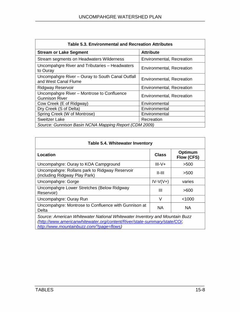
UNCOMPAHGRE WATERSHED PLAN
TABLES
15-8
Table 5.3. Environmental and Recreation Attributes
Stream or Lake Segment Attribute
Stream segments on Headwaters Wilderness Environmental, Recreation
Uncompahgre River and Tributaries – Headwaters to Ouray
Environmental, Recreation
Uncompahgre River – Ouray to South Canal Outfall and West Canal Flume
Environmental, Recreation
Ridgway Reservoir Environmental, Recreation
Uncompahgre River – Montrose to Confluence Gunnison River
Environmental, Recreation
Cow Creek (E of Ridgway) Environmental
Dry Creek (S of Delta) Environmental
Spring Creek (W of Montrose) Environmental
Sweitzer Lake Recreation
Source: Gunnison Basin NCNA Mapping Report (CDM 2009)
Table 5.4. Whitewater Inventory
Location Class Optimum
Flow (CFS)
Uncompahgre: Ouray to KOA Campground III-V+ >500
Uncompahgre: Rollans park to Ridgway Reservoir (including Ridgway Play Park)
II-III >500
Uncompahgre: Gorge IV-V(V+) varies
Uncompahgre Lower Stretches (Below Ridgway Reservoir)
III >600
Uncompahgre: Ouray Run V <1000
Uncompahgre: Montrose to Confluence with Gunnison at Delta
NA NA
Source: American Whitewater National Whitewater Inventory and Mountain Buzz (http://www.americanwhitewater.org/content/River/state-summary/state/CO/, http://www.mountainbuzz.com/?page=flows)

UNCOMPAHGRE WATERSHED PLAN
TABLES 15-9
REGION: 10
BASIN: Uncompahgre River
Desig Classifications NUMERIC STANDARDS TEMPORARY
MODIFICATIONS AND
QUALIFIERS PHYSICAL and
BIOLOGICAL
INORGANIC mg/l
METALS WBID and Stream Segment Description
1. All tributaries to the Uncompahgre River, including all wetlands, which are within the Mt. Sneffels or Uncompahgre Wilderness Areas.
OW Aq Life Cold 1
Recreation E
Water Supply Agriculture
T=TVS(CS-I) oC
D.O.=6.0 mg/l D.O.(sp)=7.0 mg/l
pH=6.5-9.0 E.Coli=126/100ml
NH3(ac/ch)=TVS Cl2(ac)=0.019 Cl2(ch)=0.011 CN=.005
S=0.002 B=0.75
NO2=0.05 NO3=10 Cl=250 SO4=WS
As(ac)=340 As(ch)=0.02(Trec)
Cd(ac)=TVS(tr) Cd(ch)=TVS CrIII(ac)=50(Trec) CrIII(ch)=TVS CrVI(ac/ch)=TVS Cu(ac/ch)=TVS
Fe(ch)=WS(dis) Fe(ch)=1000(Trec) Pb(ac/ch)=TVS Mn(ch)=50 Mn(ac/ch)=TVS Mn(ch)=WS(dis) Hg(ch)=0.01(Tot) Mo(ch)=160(Trec)
Ni(ac/ch)=TVS Se(ac/ch)=TVS Ag(ac)=TVS Ag(ch)=TVS(tr) Zn(ac/ch)=TVS
2. Mainstem of the Uncompahgre River from the source (Poughkeepsie Gulch) to a point immediately above the confluence with Red Mountain Creek.
Aq Life Cold 1 Recreation P
Water Supply Agriculture
T=TVS(CS-I) oC
D.O.=6.0 mg/l D.O.(sp)=7.0 mg/l pH=6.5-9.0 E.Coli=205/100ml
NH3(ac/ch)=TVS Cl2(ac)=0.019 Cl2(ch)=0.011 CN=.005
S=0.002 B=0.75 NO2=0.05 NO3=10 Cl=250 SO4=WS
As(ac)=340 As(ch)=0.02(Trec) Cd(ac)=TVS(tr) Cd(ch)=TVS CrIII(ch)=50 (Trec) CrIII(ch)=TVS CrVI(ac/ch)=TVS Cu(ac/ch)=TVS
Fe(ch)=WS(dis) Fe(ch)=1000(Trec) Pb(ac/ch)=TVS Mn(ac/ch)=TVS Mn(ch)=WS(dis) Hg(ch)=0.01(Tot) Mo(ch)=160(Trec
Ni(ac/ch)=TVS Se(ac/ch)=TVS Ag(ac)=TVS Ag(ch)=TVS(tr) Zn(ac/ch)=TVS
3a. Mainstem of the Uncompahgre River from a point immediately above the confluence with Red Mountain Creek to a point immediately above the confluence with Cascade Creek.
Aq Life Cold 1 Recreation E
Water Supply Agriculture
T=TVS(CS-I) oC
D.O.=6.0 mg/l D.O.(sp)=7.0 mg/l pH=6.5-9.0 E.Coli=126/100ml
NH3(ac/ch)=TVS Cl2(ac)=0.019 Cl2(ch)=0.011 CN=.005
S=0.002 B=0.75 NO2=0.05 NO3=10 Cl=250 SO4=WS
As(ac)=340 As(ch)=0.02 (Trec) Cd(ac)=TVS(tr) Cd(ch)=TVS CrIII(ac)=50(Trec) CrIII(ch)=TVS CrVI(ac/ch)=TVS
Cu(ac/ch)=TVS Fe(ch)=WS(dis) Fe(ch)= 2296(Trec) Pb(ac/ch)=TVS Mn(ac/ch)=TVS Mn(ch)=WS(dis) Hg(ch)=0.01(Tot) Mo(ch)=160(Trec
Ni(ac/ch)=TVS Se(ac/ch)=TVS Ag(ac)=TVS Ag(ch)=TVS(tr) Zn(ac/ch)=TVS
3b. Mainstem of the Uncompahgre River from a point immediately above the confluence with Cascade Creek to a point immediately above the confluence with Dexter Creek.
Aq Life Cold 1 Recreation E
Water Supply Agriculture
June-Oct 15 T(DM)=21.7°C T(MW AT)=17.0°C Oct 16-May T(DM)=13.0°C T(MW AT)=9.0°C D.O.=6.0 mg/l D.O.(sp)=7.0 mg/l pH=6.5-9.0 E.Coli=126/100ml
NH3(ac/ch)=TVS Cl2(ac)=0.019 Cl2(ch)=0.011 CN=.005
S=0.002 B=0.75 NO2=0.05 NO3=10 Cl=250 SO4=WS
As(ac)=340 As(ch)= 0.02(Trec)
Cd(ac)=TVS(tr) Cd(ch)=TVS CrIII(ac)=50(Trec) CrIII(ch)=TVS CrVI(ac/ch)=TVS
Cu(ac/ch)=TVS Fe(ch)=WS(dis) Fe(ch)= 4067(Trec) Pb(ac/ch)=TVS Mn(ch)=WS(dis) Mn(ac/ch)=TVS Hg(ch)=0.01(Tot) Mo(ch)=160(Trec)
Ni(ac/ch)=TVS Se(ac/ch)=TVS Ag(ac)=TVS Ag(ch)=TVS(tr) Zn(ac/ch)=TVS
3c. Mainstem of the Uncompahgre River from a point immediately above the confluence with Dexter Creek to a point immediately below the confluence with Dallas Creek.
Aq Life Cold 1
Recreation E Water Supply Agriculture
T=TVS(CS-I) oC
D.O.=6.0 mg/l D.O.(sp)=7.0 mg/l
pH=6.5-9.0 E.Coli=126/100ml
NH3(ac/ch)=TVS Cl2(ac)=0.019 Cl2(ch)=0.011 CN=0.005
S=0.002 B=0.75 NO2=0.05 NO3=10 Cl=250 SO4=WS
As(ac)=340
As(ch)=0.02(Trec) Cd(ac)=TVS(tr) Cd(ch)=TVS CrIII(ac)=50(Trec) CrIII(ch)=TVS CrVI(ac/ch)=TVS Cu(ac/ch)=TVS
Fe(ch)=WS(dis) Fe(ch)=2682(Trec) Pb(ac/ch)=TVS Mn(ac/ch)=TVS Mn(ch)=WS(dis) Hg(ch)=0.01(Tot) Mo(ch)=160(Trec) Ni(ac/ch)=TVS
Se(ac/ch)=TVS Ag(ac)=TVS Ag(ch)=TVS(tr) Zn(ac/ch)=TVS
3d. Mainstem of the Uncompahgre River from a point immediately below the confluence with Dallas Creek to the inlet of Ridgway Reservoir.
Aq Life Cold 1
Recreation E
Water Supply Agriculture
T=TVS(CS-II) oC
D.O.=6.0 mg/l D.O.(sp)=7.0 mg/l pH=6.5-9.0 E.Coli=126/100ml
NH3(ac/ch)=TVS
Cl2(ac)=0.019 Cl2(ch)=0.011 CN=0.005
S=0.002 B=0.75 NO2=0.05 NO3=10 Cl=250 SO4=WS
As(ac)=340 As(ch)=0.02(Trec) Cd(ac)=TVS(tr) Cd(ch)=TVS CrIII(ac)=50(Trec) CrIII(ch)=TVS CrVI(ac/ch)=TVS Cu(ac/ch)=TVS
Fe(ch)=WS(dis) Fe(ch)=2053(Trec) Pb(ac/ch)=TVS Mn(ac/ch)=TVS Mn(ch)=WS(dis) Hg(ch)=0.01(Tot) Mo(ch)=160(Trec) Ni(ac/ch)=TVS
Se(ac/ch)=TVS Ag(ac)=TVS Ag(ch)=TVS(tr) Zn(ac/ch)=TVS
Table 7.1. Water Quality Standards and Use Classifications. TVS =Table Value Standard, ac = acute, ch = chronic, dis = dissolved, tot = total

UNCOMPAHGRE WATERSHED PLAN
TABLES
15-10
REGION: 10
BASIN: Uncompahgre River
Desig Classifications NUMERIC STANDARDS TEMPORARY
MODIFICATIONS AND
QUALIFIERS PHYSICAL
and BIOLOGICAL
INORGANIC mg/l
METALS WBID and Stream Segment Description 3e. Mainstem of the Uncompahgre River from the outlet of Ridgway
Reservoir to a point immediately above the outlet of the South Canal near Uncompahgre.
Aq Life Cold 1 Recreation E
Water Supply Agriculture
T=TVS(CS-II) oC
D.O.=6.0 mg/l D.O.(sp)=7.0 mg/l pH=6.5-9.0 E.Coli=126/100ml
NH3(ac/ch)=TVS Cl2(ac)=0.019 Cl2(ch)=0.011 CN=0.005
S=0.002 B=0.75
NO2=0.05 NO3=10 Cl=250 SO4=WS
As(ac)=340 As(ch)=0.02(Trec)
Cd(ac)=TVS(tr) Cd(ch)=TVS CrIII(ac)=50(Trec) CrIII(ch)=TVS CrVI(ac/ch)=TVS
Cu(ac/ch)=TVS Fe(ch)=WS(dis) Fe(ch)=1000(Trec) Pb(ac/ch)=TVS Mn(ac/ch)=TVS Mn(ch)=WS(dis) Hg(ch)=0.01(Tot) Mo(ch)=160(Trec) Ni(ac/ch)=TVS
Se(ac/ch)=TVS Ag(ac)=TVS Ag(ch)=TVS(tr) Zn(ac/ch)=TVS
3f. Mainstem of the Uncompahgre River from a point immediately above the outlet of the South Canal to a point immediately above the Highway 90 bridge in Montrose.
Aq Life Cold 1
Recreation E
Water Supply Agriculture
T=TVS(CS-II) oC
D.O.=6.0 mg/l D.O.(sp)=7.0 mg/l pH=6.5-9.0 E.Coli=126/100ml
NH3(ac/ch)=TVS Cl2(ac)=0.019 Cl2(ch)=0.011 CN=0.005
S=0.002 B=0.75 NO2=0.05 NO3=10 Cl=250 SO4=WS
As(ac)=340
As(ch)=0.02(Trec)
Cd(ac)=TVS(tr) Cd(ch)=TVS CrIII(ac)=50(Trec) CrIII(ch)=TVS CrVI(ac/ch)=TVS
Cu(ac/ch)=TVS Fe(ch)=WS(dis) Fe(ch)=1000(Trec) Pb(ac/ch)=TVS Mn(ac/ch)=TVS Mn(ch)=WS(dis) Hg(ch)=0.01(Tot) Mo(ch)=160(Trec) Ni(ac/ch)=TVS
Se(ac/ch)=TVS Ag(ac)=TVS Ag(ch)=TVS(tr) Zn(ac/ch)=TVS
4a. Mainstem of the Uncompahgre River from the Highway 90 bridge at Montrose to Gunnison Road. Aq Life Warm 1
Recreation E
Water Supply Agriculture
T=TVS(WS-II) oC
D.O.=5.0 mg/l pH=6.5-9.0 E.Coli=126/100ml
NH3(ac/ch)=TVS Cl2(ac)=0.019 Cl2(ch)=0.011 CN=.005
S=0.002 B=0.75 NO2=0.5 NO3=10 Cl=250 SO4=WS
As(ac)=340
As(ch)= 0.02(Trec)
Cd(ac/ch)=TVS CrIII(ac)=50(Trec) CrIII(ch)=TVS CrVI(ac/ch)=TVS Cu(ac/ch)=TVS
Fe(ch)=WS(dis) Fe(ch)= 1000(Trec) Pb(ac/ch)=TVS Mn(ac/ch)=TVS Mn(ch)=WS(dis) Hg(ch)=0.01(Tot) Mo(ch)=160(Trec) Ni(ac/ch)=TVS
Se(ac/ch)=TVS Ag(ac)=TVS Ag(ch)=TVS Zn(ac/ch)=TVS
4b. Mainstem of the Uncompahgre River from Gunnison Road to the upstream boundary of Confluence Park.
UP
Aq Life Warm 2 Recreation P
Water Supply Agriculture
T=TVS(WS-II) oC
D.O.=5.0 mg/l pH=6.5-9.0 E.Coli=205/100ml
NH3(ac/ch)=TVS Cl2(ac)=0.019 Cl2(ch)=0.011 CN=.005
S=0.002 B=0.75
NO2=0.5 NO3=10 Cl=250 SO4=WS
As(ac)=340 As(ch)= 0.02(Trec)
Cd(ac/ch)=TVS CrIII(ac)=50(Trec) CrIII(ch)=TVS CrVI(ac/ch)=TVS Cu(ac/ch)=TVS
Fe(ch)=WS(dis) Fe(ch)= 1800 (Trec) Pb(ac/ch)=TVS Mn(ac/ch)=TVS Mn(ch)=WS(dis) Hg(ch)=0.01(Tot) Mo(ch)=160(Trec) Ni(ac/ch)=TVS
Se(ac/ch)=TVS Ag(ac)=TVS Ag(ch)=TVS Zn(ac/ch)=TVS
Temporary Modification: Type A Se(ch)= current
conditions Expiration date of Dec. 31, 2017
4c. Mainstem of the Uncompahgre River from the upstream boundary of Confluence Park to the confluence with the Gunnison River. Aq Life Warm 1
Recreation E Agriculture
T=TVS(WS-II) oC
D.O.=5.0 mg/l pH=6.5-9.0 E.Coli=126/100ml
NH3(ac/ch)=TVS Cl2(ac)=0.019 Cl2(ch)=0.011 CN=.005
S=0.002 B=0.75 NO2=0.5 NO3=100
As(ac)=340
As(ch)= 7.6(Trec) Cd(ac/ch)=TVS CrIII(ac/ch)=TVS CrIII(ch)=100(Trec) CrVI(ac/ch)=TVS Cu(ac/ch)=TVS
Fe(ch)= 2356(Trec) Pb(ac/ch)=TVS Mn(ac/ch)=TVS Hg(ch)=0.01(Tot) Mo(ch)=160(Trec) Ni(ac/ch)=TVS
Se(ac/ch)=TVS Ag(ac)=TVS Ag(ch)=TVS Zn(ac/ch)=TVS
5. All tributaries to the Uncompahgre River, including all wetlands, from the source to a point immediately below the confluence with Dexter Creek, except for specific listings in Segments 1, 6a, 6b, and 7 through 9.
Aq Life Cold 2 Recreation E Water Supply Agriculture
T=TVS(CS-I) oC
D.O.=6.0 mg/l D.O.(sp)=7.0 mg/l pH=6.5-9.0 E.Coli=126/100ml
NH3(ac/ch)=TVS Cl2(ac)=0.019 Cl2(ch)=0.011 CN=.005
S=0.002 B=0.75 NO2=0.05 NO3=10 Cl=250 SO4=WS
As(ac)=340
As(ch)=0.02- 1
10(Trec) Cd(ac)=TVS(tr) Cd(ch)=TVS CrIII(ac)=50(Trec) CrIII(ch)=TVS CrVI(ac/ch)=TVS Cu(ac/ch)=TVS
Fe(ch)=WS(dis) Fe(ch)=1000(Trec) Pb(ac/ch)=TVS Mn(ac/ch)=TVS Mn(ch)=WS(dis) Hg(ch)=0.01(Tot) Mo(ch)=160(Trec)
Ni(ac/ch)=TVS Se(ac/ch)=TVS Ag(ac)=TVS Ag(ch)=TVS(tr) Zn(ac/ch)=TVS
6a. Mainstem of Red Mountain Creek from the source to immediately above the confluence with the East Fork of Red Mountain Creek. Aq Life Cold 2
Recreation N Agriculture
T=TVS(CS-I) oC
D.O.=6.0 mg/l D.O.(sp)=7.0 mg/l pH=6.5-9.0 E.Coli=630/100ml
NH3(ac/ch)=TVS Cl2(ac)=0.019 Cl2(ch)=0.011 CN=.005
S=0.002 B=0.75 NO2=0.05 NO3=100
As(ac)=340
As(ch)= 100(Trec) Cd(ac/ch)=TVS CrIII(ac/ch)=TVS CrIII(ch)=100(Trec) CrVI(ac/ch)=TVS Cu(ac/ch)=TVS
Fe(ch)=1000(Trec) Pb(ac/ch)=TVS Mn(ac/ch)=TVS Hg(ch)=0.01(Tot) Mo(ch)=160(Trec) Ni(ac/ch)=TVS
Se(ac/ch)=TVS Ag(ac/ch)=TVS Zn(ac/ch)=TVS
6b. Mainstem of Red Mountain Creek from immediately above the confluence with the East Fork of Red Mountain Creek to the confluence with the Uncompahgre River. All tributaries to Red Mountain Creek within Corkscrew and Champion basins.
UP Recreation N Agriculture
D.O. = 3.0 mg/l pH = ambient E.Coli=630/100ml

UNCOMPAHGRE WATERSHED PLAN
TABLES
15-11
REGION: 10
BASIN: Uncompahgre River
Desig Classifications NUMERIC STANDARDS TEMPORARY
MODIFICATIONS AND
QUALIFIERS PHYSICAL
and BIOLOGICAL
INORGANIC mg/l
METALS WBID and Stream Segment Description 7. Mainstem of Gray Copper Gulch from the source to the confluence
with Red Mountain Creek. Aq Life Cold 2 Recreation P
Water Supply Agriculture
T=TVS(CS-I) oC
D.O.=6.0 mg/l D.O.(sp)=7.0 mg/l pH=6.5-9.0 E.Coli=205/100ml
NH3(ac/ch)=TVS Cl2(ac)=0.019 Cl2(ch)=0.011 CN=.005
S=0.002 B=0.75 NO2=0.05 NO3=10 Cl=250 SO4=WS
As(ac)=340
As(ch)=0.02-10(Trec)1
Cd(ac)=TVS(tr) Cd(ch)=TVS CrIII(ac)=50(Trec) CrIII(ch)=TVS CrVI(ac/ch)=TVS Cu(ac/ch)=TVS
Fe(ch)=WS(dis) Fe(ch)= 2700(Trec) Pb(ac/ch)=TVS Mn(ch)=655 Mn(ac/ch)=TVS Hg(ch)=0.01(Tot) Mo(ch)=160(Trec)
Ni(ac/ch)=TVS Se(ac/ch)=TVS Ag(ac)=TVS Ag(ch)=TVS(tr) Zn(ac/ch)=TVS
8. Mainstem of Mineral Creek from the source to the confluence with the Uncompahgre River. Aq Life Cold 2
Recreation P Water Supply Agriculture
T=TVS(CS-I) oC
D.O.=6.0 mg/l D.O.(sp)=7.0 mg/l pH=6.5-9.0 E.Coli=205/100ml
NH3(ac/ch)=TVS Cl2(ac)=0.019 Cl2(ch)=0.011 CN=.005
S=0.002 B=0.75 NO2=0.05 NO3=10 Cl=250 SO4=WS
As(ac)=340
As(ch)=0.02-10(Trec)1
Cd(ac)=TVS(tr) Cd(ch)= TVS CrIII(ac)=50(Trec) CrIII(ch)=TVS CrVI(ac/ch)=TVS Cu(ch)=5
Fe(ch)=WS(dis) Fe(ch)=1000 (Trec) Pb(ch)=4 Mn(ac/ch)=TVS Mn(ch)=WS(dis) Hg(ch)=0.01(Tot)
Mo(ch)=160(Trec) Ni(ac/ch)=TVS
Se(ac/ch)= TVS Ag(ac)=TVS Ag(ch)= TVS(tr) Zn(ac/ch)= TVS
9 Mainstem of Imogene Creek from its source to its confluence with Sneffels Creek. Mainstem and all tributaries of Sneffels Creek from a point 1.5 miles above its confluence with Imogene Creek at 37.974979, -107.753960 (WGS84) to its confluence with Imogene Creek. Mainstem of Canyon Creek from its inception at the confluence of Imogene Creek and Sneffles Creek to the confluence with the Uncompahgre River.
Aq Life Cold 2
Recreation P Agriculture
T=TVS(CS-I) oC
D.O.=6.0 mg/l D.O.(sp)=7.0 mg/l pH=6.5-9.0 E.Coli=205/100ml
NH3(ac/ch)=TVS Cl2(ac)=0.019 Cl2(ch)=0.011 CN=.005
S=0.002 B=0.75 NO2=0.05 NO3=100
As(ac)=340
As(ch)=7.6(Trec) Cd(ac)=TVS(tr) Cd(ch)=TVS CrIII(ac/ch)=TVS CrIII(ch)=100(Trec) CrVI(ac/ch)=TVS Cu(ac/ch)=TVS
Fe(ch)=1000 (Trec) Pb(ac/ch)=TVS Mn(ac/ch)=TVS Hg(ch)=0.01(Tot) Mo(ch)=160(Trec) Ni(ac/ch)=TVS
Se(ac/ch)=TVS Ag(ac)=TVS Ag(ch)=TVS(tr) Zn(ac/ch)=TVS
Fish Ingestion
10. All tributaries to the Uncompahgre River, including all wetlands, from a point immediately below the confluence with Dexter Creek to the South Canal near Uncompahgre, except for specific listings in Segments 1 and 11.
Aq Life Cold 1
Recreation P
Water Supply Agriculture
T=TVS(CS-II) oC
D.O.=6.0 mg/l D.O.(sp)=7.0 mg/l pH=6.5-9.0 E.Coli=205/100ml
NH3(ac/ch)=TVS Cl2(ac)=0.019 Cl2(ch)=0.011 CN=.005
S=0.002 B=0.75 NO2=0.05 NO3=10 Cl=250 SO4=WS
As(ac)=340
As(ch)=0.02(Trec)
Cd(ac)=TVS(tr) Cd(ch)=TVS CrIII(ac)=50(Trec) CrIII(ch)=TVS CrVI(ac/ch)=TVS Cu(ac/ch)=TVS
Fe(ch)=WS(dis) Fe(ch)=1000 (Trec) Pb(ac/ch)=TVS Mn(ch)=WS(dis) Mn(ac/ch)=TVS Hg(ch)=0.01(Tot) Mo(ch)=160(Trec)
Ni(ac/ch)=TVS Se(ac/ch)=TVS Ag(ac)=TVS Ag(ch)=TVS(tr) Zn(ac/ch)=TVS Zn(ch)=TVS(sc)
11. Mainstem of Coal Creek from the source to the Park Ditch, mainstem of Dallas Creek from the source of the East and West Forks to the confluence with the Uncompahgre River; mainstem of Cow Creek, including all tributaries, from the Uncompahgre Wilderness Area boundary to the confluence with the Uncompahgre River; mainstems of Billy Creek, Onion Creek and Beaton Creek from their sources to their confluences with Uncompahgre River; mainstem of Beaver Creek from the source to the confluence with the East Fork of Dallas Creek; and mainstem of Pleasant Valley Creek from the source to the confluence with Dallas Creek.
Aq Life Cold 1
Recreation P Water Supply Agriculture
T=TVS(CS-I) oC
D.O.=6.0 mg/l D.O.(sp)=7.0 mg/l pH=6.5-9.0 E.Coli=205/100ml
NH3(ac/ch)=TVS Cl2(ac)=0.019 Cl2(ch)=0.011 CN=.005
S=0.002 B=0.75 NO2=0.05 NO3=10 Cl=250 SO4=WS
As(ac)=340
As(ch)=0.02(Trec) Cd(ac)=TVS(tr) Cd(ch)=TVS CrIII(ac)=50(Trec) CrIII(ch)=TVS CrVI(ac/ch)=TVS Cu(ac/ch)=TVS
Fe(ch)=WS(dis) Fe(ch)=1000(Trec) Pb(ac/ch)=TVS Mn(ac/ch)=TVS Mn(ch)=WS(dis) Hg(ch)=0.01 (Tot) Mo(ch)=160(Trec)
Ni(ac/ch)=TVS Se(ac/ch)=TVS Ag(ac)=TVS Ag(ch)=TVS(tr) Zn(ac/ch)=TVS
12. All tributaries to the Uncompahgre River, including all wetlands, from the South Canal near Uncompahgre to the confluence with the Gunnison River, except for specific listings in Segments 13, 14, 15a and 15b.
UP
Aq Life Warm 1 Recreation P
Agriculture
T=TVS(WS-II) oC
D.O.=5.0 mg/l pH=6.5-9.0 E.Coli=205/100ml
NH3(ac/ch)=TVS Cl2(ac)=0.019 Cl2(ch)=0.011 CN=.005
S=0.002 B=0.75
NO2=0.05 NO3=100
As(ac)=340 As(ch)= 7.6(Trec)
Cd(ac/ch)=TVS CrIII(ac/ch)=TVS Cr(ch)=100(Trec) CrVI(ac/ch)=TVS Cu(ac/ch)=TVS
Fe(ch)=1400(Trec) Pb(ac/ch)=TVS Mn(ac/ch)=TVS Hg(ch)=0.01(Tot) Mo(ch)=160(Trec) Ni(ac/ch)=TVS
Se(ac/ch)=TVS Ag(ac/ch)=TVS Zn(ac/ch)=TVS
13. Mainstem of East Fork Dry Creek, Pryor Creek and West Fork Dry Creek from their sources to their confluence; mainstem of Spring Creek, West Fork Spring Creek and Middle Spring Creek from the source to Popular Road at the mouth of Spring Canyon, and mainstem of Mexican Gulch from the source to the Section line dividing Section 19 and 30, T49N, R9W.
Aq Life Cold 1
Recreation E Agriculture
T=TVS(CS-I) oC
D.O.=6.0 mg/l D.O.(sp)=7.0 mg/l pH=6.5-9.0 E.Coli=126/100ml
NH3(ac/ch)=TVS Cl2(ac)=0.019 Cl2(ch)=0.011 CN=.005
S=0.002 B=0.75 NO2=0.05 NO3=100
As(ac)=340 As(ch)=7.6(Trec) Cd(ac)=TVS(tr) Cd(ch)=TVS CrIII(ac/ch)=TVS CrIII(ch)=100(Trec) CrVI(ac/ch)=TVS Cu(ac/ch)=TVS
Fe(ch)=1000(Trec) Pb(ac/ch)=TVS Mn(ac/ch)=TVS Hg(ch)=0.01(Tot) Mo(ch)=160(Trec) Ni(ac/ch)=TVS Se(ac/ch)=TVS
Ag(ac)=TVS Ag(ch)=TVS(tr) Zn(ac/ch)=TVS

UNCOMPAHGRE WATERSHED PLAN
TABLES
15-12
REGION: 10
BASIN: Uncompahgre River
Desig Classifications NUMERIC STANDARDS TEMPORARY
MODIFICATIONS AND
QUALIFIERS PHYSICAL
and BIOLOGICAL
INORGANIC mg/l
METALS WBID and Stream Segment Description
14. East and West Forks of Horsefly Creek, including all tributaries and wetlands, from their sources to a point immediately above their confluence. Happy Canyon Creek, including all tributaries and wetlands, from the source to the most downstream national forest boundary.
Aq Life Cold 2
Recreation P Agriculture
T=TVS(CS-II) oC
D.O.=6.0 mg/l D.O.(sp)=7.0 mg/l pH=6.5-9.0 E.Coli=206/100ml
NH3(ac/ch)=TVS Cl2(ac)=0.019 Cl2(ch)=0.011 CN=.005
S=0.002 B=0.75 NO2=0.5 NO3=100
As(ac)=340 As(ch)=100(Trec) Cd(ac)=TVS(tr) Cd(ch)=TVS CrIII(ac/ch)=TVS CrIII(ch)=100(Trec) CrVI(ac/ch)=TVS Cu(ac/ch)=TVS
Fe(ch)=1000(Trec) Pb(ac/ch)=TVS Mn(ac/ch)=TVS Hg(ch)=0.01(Tot) Mo(ch)=160(Trec) Ni(ac/ch)=TVS
Se(ac/ch)=TVS Ag(ac)=TVS Ag(ch)=TVS(tr) Zn(ac/ch)=TVS
15a. Mainstem of Happy Canyon from a point immediately below the West Canal to the confluence with the Uncompahgre River; mainstem of Horsefly Creek from a point immediately below the confluence with Wildcat Canyon to the confluence with the Uncompahgre River.
Aq Life Warm 1
Recreation P Agriculture
T=TVS(WS-II) oC
D.O.=5.0 mg/l pH=6.5-9.0 E.Coli=205/100ml
NH3(ac/ch)=TVS Cl2(ac)=0.019 Cl2(ch)=0.011 CN=.005
S=0.002 B=0.75 NO2=0.5 NO3=100
As(ac)=340 As(ch)= 7.6(Trec) Cd(ac/ch)=TVS CrIII(ac/ch)=TVS CrIII(ch)=100(Trec) CrVI(ac/ch)=TVS Cu(ac/ch)=TVS
Fe(ch)=1000(Trec) Pb(ac/ch)=TVS Mn(ac/ch)=TVS Hg(ch)=0.01(Tot) Mo(ch)=160(Trec) Ni(ac/ch)=TVS
Se(ac/ch)=TVS Ag(ac)=TVS Ag(ch)=TVS Zn(ac/ch)=TVS
15b. Mainstem of Dry Creek from the confluence of the East and West Forks to immediately above the confluence with Coalbank Canyon Creek.
Aq Life Cold 2
Recreation E
Agriculture
T=TVS(CS-II) oC
D.O.= 6.0 mg/l D.O.(sp)=7.0 mg/l pH=6.5-9.0 E.Coli=126/100ml
NH3(ac/ch)=TVS Cl2(ac)=0.019 Cl2(ch)=0.011 CN=.005
S=0.002 B=0.75 NO2=0.5
NO3=100
As(ac)=340
As(ch)=100(Trec)
Cd(ac)=TVS(tr) Cd(ch)=TVS CrIII(ac/ch)=TVS CrIII(ch)=100(Trec) CrVI(ac/ch)=TVS Cu(ac/ch)=TVS
Fe(ch)=1000(Trec) Pb(ac/ch)=TVS Mn(ac/ch)=TVS Hg(ch)=0.01(Tot) Mo(ch)=160(Trec) Ni(ac/ch)=TVS
Se(ac/ch)=TVS Ag(ac)=TVS Ag(ch)=TVS(tr) Zn(ac/ch)=TVS
16. All lakes and reservoirs tributary to the Uncompahgre River and within the Mt. Sneffels or Uncompahgre Wilderness Areas.
OW
Aq Life Cold 1
Recreation E
Water Supply Agriculture
T=TVS(CL) oC
D.O.=6.0 mg/l D.O.(sp)=7.0 mg/l pH=6.5-9.0 E.Coli=126/100ml
NH3(ac/ch)=TVS Cl2(ac)=0.019 Cl2(ch)=0.011 CN=0.005
S=0.002 B=0.75
NO2=0.05 NO3=10 Cl=250 SO4=WS
As(ac)=340
As(ch)=0.02(Trec)
Cd(ac)=TVS(tr) Cd(ch)=TVS CrIII(ac)=50(Trec) CrIII(ch)=TVS CrVI(ac/ch)=TVS Cu(ac/ch)=TVS
Fe(ch)=WS(dis) Fe(ch)=1000(Trec) Pb(ac/ch)=TVS Mn(ch)=50 Mn(ac/ch)=TVS Mn(ch)=WS(dis) Hg(ch)=0.01(Tot) Mo(ch)=160(Trec) Ni(ac/ch)=TVS
Se(ac/ch)=TVS Ag(ac)=TVS Ag(ch)=TVS(tr) Zn(ac/ch)=TVS
17. All lakes and reservoirs tributary to the Uncompahgre River from the source to a point immediately below the confluence with Dexter Creek, except for specific listings in Segments 16. This segment includes Lake Como, Ptarmigan Lake, Crystal Lake, and Lake Lenore.
Aq Life Cold 1
Recreation E
Water Supply Agriculture
T=TVS(CL) oC
D.O.=6.0 mg/l D.O.(sp)=7.0 mg/l pH=6.5-9.0 E.Coli=126/100ml
NH3(ac/ch)=TVS Cl2(ac)=0.019 Cl2(ch)=0.011 CN=0.005
S=0.002 B=0.75 NO2=0.05 NO3=10 Cl=250 SO4=WS
As(ac)=340 1
As(ch)=0.02-10(Trec) Cd(ac)=TVS(tr) Cd(ch)=TVS CrIII(ac)=50(Trec) CrIII(ch)=TVS CrVI(ac/ch)=TVS Cu(ac/ch)=TVS
Fe(ch)=WS(dis) Fe(ch)=1000(Trec) Pb(ac/ch)=TVS Mn(ac/ch)=TVS Mn(ch)=WS(dis) Hg(ch)=0.01(Tot) Mo(ch)=160(Trec) Ni(ac/ch)=TVS
Se(ac/ch)=TVS Ag(ac)=TVS Ag(ch)=TVS(tr) Zn(ac)=TVS
18. All lakes and reservoirs tributary to the Uncompahgre River from a point immediately below the confluence with Dexter Creek to a point immediately below the South Canal near Uncompahgre, excluding the listings in Segment 16 and 19. All lakes and reservoirs tributary to the East Fork of Dry Creek or the West Fork of Dry Creek from their sources to their confluence. This segment includes Black Lake, Blue Lakes, Ulah Brown Spring, Lake Otonawanda, West Lake, Dry Lake, Elephant Reservoir, Buckhorn Lakes, Silesca Pond and Olathe Reservoirs 1 and 2.
Aq Life Cold 1 Recreation P Water Supply Agriculture
T=TVS(CL) oC
D.O.=6.0 mg/l D.O.(sp)=7.0 mg/l pH=6.5-9.0 E.Coli=205/100ml
NH3(ac/ch)=TVS Cl2(ac)=0.019 Cl2(ch)=0.011 CN=0.005
S=0.002 B=0.75 NO2=0.05 NO3=10 Cl=250 SO4=WS
As(ac)=340 As(ch)=0.02(Trec) Cd(ac)=TVS(tr) Cd(ch)=TVS CrIII(ac)=50(Trec) CrIII(ch)=TVS CrVI(ac/ch)=TVS Cu(ac/ch)=TVS
Fe(ch)=WS(dis) Fe(ch)=1000 (Trec) Pb(ac/ch)=TVS Mn(ch)=WS(dis) Mn(ac/ch)=TVS Hg(ch)=0.01(Tot) Mo(ch)=160(Trec) Ni(ac/ch)=TVS
Se(ac/ch)=TVS Ag(ac)=TVS Ag(ch)=TVS(tr) Zn(ac/ch)=TVS
19. Ridgway Reservoir. Aq Life Cold 1
Recreation E Agriculture
T=TVS(CLL) oC
D.O.=6.0 mg/l D.O.(sp)=7.0 mg/l pH=6.5-9.0 E.Coli=126/100ml
NH3(ac/ch)=TVS Cl2(ac)=0.019 Cl2(ch)=0.011 CN=0.005
S=0.002 B=0.75 NO2=0.05 NO3=100
As(ac)=340 As(ch)=7.6(Trec) Cd(ac)=TVS(tr) Cd(ch)=TVS CrIII(ac/ch)=TVS CrIII(ch)=100(Trec) CrVI(ac/ch)=TVS
Cu(ac/ch)=TVS Fe(ch)=1000(Trec) Pb(ac/ch)=TVS Mn(ac/ch)=TVS Hg(ch)=0.01(Tot)
Mo(ch)=160(Trec) Ni(ac/ch)=TVS
Se(ac/ch)=TVS Ag(ac)=TVS Ag(ch)=TVS(tr) Zn(ac/ch)=TVS

UNCOMPAHGRE WATERSHED PLAN
TABLES
15-13
REGION: 10
BASIN: Uncompahgre River
Desig Classifications NUMERIC STANDARDS TEMPORARY
MODIFICATIONS AND
QUALIFIERS PHYSICAL
and BIOLOGICAL
INORGANIC mg/l
METALS WBID and Stream Segment Description
20. Sweitzer Lake (a.k.a. Garnet Mesa Reservoir). Aq Life Warm 1
Recreation E
Agriculture
T=TVS(WL) oC
D.O.=5.0 mg/l pH=6.5-9.0 E.Coli=126/100ml
NH3(ac/ch)=TVS Cl2(ac)=0.019 Cl2(ch)=0.011 CN=0.005
S=0.002 B=0.75 NO2=0.5 NO3=100
As(ac)=340
As(ch)=7.6 (Trec)
Cd(ac/ch)=TVS CrIII(ac/ch)=TVS CrIII(ch)=100(Trec) CrVI(ac/ch)=TVS Cu(ac/ch)=TVS
Fe(ch)=1000(Trec) Pb(ac/ch)=TVS Mn(ac/ch)=TVS Hg(ch)=0.01(Tot) Mo(ch)=160(Trec) Ni(ac/ch)=TVS
Se(ac/ch)=TVS Ag(ac)=TVS Ag(ch)=TVS Zn(ac/ch)=TVS
21. All lakes and reservoirs tributary to the Uncompahgre River from a point immediately below the South Canal near Uncompahgre to the confluence with the Gunnison River, excluding the listings in Segments 20 and 18.
UP
Aq Life Warm 2
Recreation P Agriculture
T=TVS(WL) oC
D.O.=5.0 mg/l pH=6.5-9.0 E.Coli=205/100ml
NH3(ac/ch)=TVS Cl2(ac)=0.019 Cl2(ch)=0.011 CN=0.005
S=0.002 B=0.75 NO2=0.05 NO3=100
As(ac)=340
As(ch)=100(Trec) Cd(ac/ch)=TVS CrIII(ac/ch)=TVS CrIII(ch)=100(Trec) CrVI(ac/ch)=TVS Cu(ac/ch)=TVS
Fe(ch)=1000 (Trec) Pb(ac/ch)=TVS Mn(ac/ch)=TVS Hg(ch)=0.01(Tot) Mo(ch)=160(Trec) Ni(ac/ch)=TVS
Se(ac/ch)=TVS Ag(ac/ch)=TVS Zn(ac/ch)=TVS
Source: Regulation #35, effective Mar. 30, 2013

UNCOMPAHGRE WATERSHED PLAN
TABLES
15-14
Table 7.2a. Impaired Waters (Effective Mar. 30, 2013)
WBID Segment Name Designation M&E 303(d) TMDL Other Considerations Priority
COGUUN01 All tributaries to the Uncompahgre River, including all wetlands which are within the Mt. Sneffels or Uncompahgre Wilderness Areas.
Outstanding Waters
COGUUN02 Mainstem of the Uncompahgre River from the source (Poughkeepsie Gulch) to a point immediately above the confluence with Red Mountain Creek.
None (Reviewable)
Pb Mn (WS) Cd, Cu, Zn (2011)
This segment is affected by historic mining.
L
COGUUN3a Mainstem of the Uncompahgre River from a point immediately above the confluence with Red Mountain Creek to a point immediately above the confluence with Cascade Creek.
None (Reviewable)
Cd, Cu, Fe(Trec) (2010)
Numerous hot springs are located in this segment. This segment is affected by historic mining.
COGUUN3b Mainstem of the Uncompahgre River from a point immediately above the confluence with Cascade Creek to a point immediately above the confluence with Dexter Creek.
None (Reviewable)
Cd, Cu, Fe(Trec) (2010)
This segment may be affected by sediment that periodically washes down Skyrocket Creek from an area known as The Blowout. Numerous hot springs are located in this segment including a large thermal discharge from the Ouray Hot Springs Pool.
COGUUN03c Mainstem of the Uncompahgre River from a point immediately above the confluence with Dexter Creek to a point immediately above the confluence with Dallas Creek.
None (Reviewable)
Cd, Cu, Fe(Trec) (2010)
COGUUN03d Mainstem of the Uncompahgre River from a point immediately below the confluence with Dallas Creek to the inlet of Ridgway Reservoir.
None (Reviewable)
Cd, Cu, Fe(Trec) (2010)
COGUUN03e Mainstem of the Uncompahgre River from the outlet of Ridgway Reservoir to a point immediately above the outlet of the South Canal near Uncompahgre.
None (Reviewable)
Cd, Cu, Fe(Trec) (2010)

UNCOMPAHGRE WATERSHED PLAN
TABLES
15-15
Table 7.2a. Impaired Waters - continued (Effective Mar. 30, 2013)
WBID Segment Name Designation M&E 303(d) TMDL Other Considerations Priority
COGUUN03f Mainstem of the Uncompahgre River from a point immediately above the outlet of the South Canal to a point immediately above the Highway 90 bridge in Montrose.
None (Reviewable)
Cd, Cu, Fe(Trec) (2010)
COGUUN04a Uncompahgre River, HWY 90 to La Salle Road. None (Reviewable)
sediment The Selenium Task Force has been studying the selenium issues in this area.
COGUUN04b Mainstem of the Uncompahgre River from La Salle Road to the upstream boundary of Confluence Park.
None (Reviewable)
sediment Se (2011)
COGUUN04c Mainstem of the Uncompahgre River from the upstream boundary of Confluence Park to the confluence with the Gunnison River.
None (Reviewable)
sediment, Pb Fe(Trec) Se (2011) H
COGUUN05 All tributaries to the Uncompahgre River, including all wetlandsfrom the source to a point immediately below the confluence with Dexter Creek, except for specific listings in Segments 1 and 6a, 6b, and 7 through 9.
None (Reviewable)
This segment is affected by historic mining.
COGUUN06a Red Mountain Creek, from the source to immediately above the confluence with East Fork Red Mountain Cr.
None (Reviewable)
Ag, Cu Zn(sc) (2010)
This segment is affected by historic mining.
M
COGUUN06b Mainstem of Red Mountain Creek from immediately above the confluence with the East Fork of Red Mountain Creek to the confluence with the Uncompahgre River. All tributaries to Red Mountain Creek within Corkscrew and Champion basins.
Use Protected
This segment is affected by historic mining.
COGUUN07 Mainstem of Gray Copper Gulch from the source to the confluence with Red Mountain Creek.
None (Reviewable)
Fe(Trec), pH Cu This segment is affected by historic mining.
M
COGUUN08 Mainstem of Mineral Creek from the source to the confluence with the Uncompahgre River.
None (Reviewable)
Cu, Zn This segment is affected by historic mining.

UNCOMPAHGRE WATERSHED PLAN
TABLES
15-16
Table 7.2a. Impaired Waters - continued (Effective Mar. 30, 2013)
WBID Segment Name Designation M&E 303(d) TMDL Other Considerations Priority
COGUUN09 Mainstem of Imogene Creek from its source to its confluence with Sneffels Creek. Mainstem and all tributaries of Sneffels Creek from a point 1.5 miles above its confluence with Imogene Creek at 37.974979, -107.753960 (WGS84) to its confluence with Imogene Creek. Mainstem of Canyon Creek from its inception at the confluence of Imogene Creek and Sneffles Creek to the confluence with the Uncompahgre River.
None (Reviewable)
Pb (Canyon Creek)
Cd, Zn (Sneffels Creek)
This segment is affected by historic mining.
H
COGUUN10 All tributaries to the Uncompahgre River, including all wetlands from a point immediately below the confluence with Dexter Creek to the South Canal near Uncompahgre, except for specific listings in Segments 1 and 11.
None (Reviewable)
Se (Alkali Creek)
COGUUN11 Mainstem of Coal Creek from the source to the Park Ditch, mainstem of Dallas Creek from the source of the East and West Forks to the confluence with the Uncompahgre River; mainstem of Cow Creek, including all tributaries from the Uncompahgre Wilderness Area boundary to the confluence with the Uncompahgre River; mainstems of Billy Creek; Onion Creek and Beaton Creek from their sources to their confluences with Uncompahgre River; mainstem of Beaver Creek from the source to the confluence with the East Fork of Dallas Creek; and mainstem of Pleasant Valley Creek from the source to the confluence with Dallas Creek.
None (Reviewable)
Se (Billy Creek, Onion Creek); SO4 (Cow Creek)
Aquatic Life (provisional) (Deer Creek)
COGUUN12 All tributaries to the Uncompahgre River, including all wetlands from the South Canal near Uncompahgre to the confluence with the Gunnison River, except for specific listings in Segments 13, 14, 15a and 15b.
Use Protected
Fe(Trec) (Dry Creek, Loutzenhizer Arroyo)
Se (2010) H

UNCOMPAHGRE WATERSHED PLAN
TABLES
15-17
Table 7.2a. Impaired Waters - continued (Effective Mar. 30, 2013)
WBID Segment Name Designation M&E 303(d) TMDL Other Considerations Priority
COGUUN13 Mainstem of East Fork Dry Creek, Pryor Creek and West Fork Dry Creek from their sources to their confluence; mainstem of Spring Creek, West Fork Spring Creek and Middle Spring Creek from the source to Popular Road at the mouth of Spring Canyon, and mainstem of Mexican Gulch from the source to the Section line dividing Section 19 and 30, T49N, R9W.
None (Reviewable)
COGUUN14 East and West Forks of Horsefly Creek, including all tributaries and wetlands, from their sources to a point immediately above their confluence. Happy Canyon Creek, including all tributaries and wetlands, from the source to the most downstream national forest boundary.
None (Reviewable)
COGUUN15a Mainstem of Happy Canyon from a point immediately below the West Canal to the confluence with the Uncompahgre River; mainstem of Horsefly Creek from a point immediately below the confluence with Wildcat Canyon to the confluence with the Uncompahgre River.
None (Reviewable)
COGUUN15b Dry Creek from East and West Forks to Coalbank Canyon Creek.
None (Reviewable)
sediment (Dry Creek Watershed)
H
COGUUN16 All lakes and reservoirs tributary to the Uncompahgre River and within the Mt. Sneffels or Uncompahgre Wilderness Areas.
Outstanding Waters
COGUUN17 All lakes and reservoirs tributary to the Uncompahgre River from the source to a point immediately below the confluence with Dexter Creek, except for specific listings in Segments 16. This segment includes Lake Como, Ptarmigan Lake, Crystal Lake, and Lake Lenore.
None (Reviewable)

UNCOMPAHGRE WATERSHED PLAN
TABLES
15-18
Table 7.2a. Impaired Waters - continued (Effective Mar. 30, 2013)
WBID Segment Name Designation M&E 303(d) TMDL Other Considerations Priority
COGUUN18 All lakes and reservoirs tributary to the Uncompahgre River from a point immediately below the confluence with Dexter Creek to a point immediately below the South Canal near Uncompahgre, excluding the listings in Segment 16 and 19. All lakes and reservoirs tributary to the East Fork of Dry Creek or the West Fork of Dry Creek from their sources to their confluence. This segment includes Black Lake, Blue Lakes, Ulah Brown Spring, Lake Otonawanda, West Lake, Dry Lake, Elephant Reservoir, Buckhorn Lakes, Silesca Pond and Olathe Reservoirs 1 and 2.
None (Reviewable)
COGUUN19 Ridgway Reservoir. None (Reviewable)
Pb, Zn (formerly COGUUN03b)
Ridgway Reservoir is a major sink for metals in the Uncompahgre River.
COGUUN20 Sweitzer Lake (a.k.a. Garnet Mesa Reservoir). None (Reviewable)
Se (formerly COGUUN14)
COGUUN21 All lakes and reservoirs tributary to the Uncompahgre River from a point immediately below the South Canal near Uncompahgre to the confluence with the Gunnison River, excluding the listings in Segments 20 and 18.
Use Protected
Source: WQCC Regulation #93 - Mar. 30, 2013 Colorado Section 303(d) list of Impaired Waters and Monitoring and Evaluation List, Notes: (*) denotes carryover from the 1998 303(d) List, consequently they are all high priority.

UNCOMPAHGRE WATERSHED PLAN
TABLES
15-19
Table 7.2b. Impaired Waters – continued (Effective Mar. 30, 2012)
WBID Segment Name Portion M&E 303(d) TMDL Priority
02 Mainstem of the Uncompahgre River from the source at Como Lake (Poughkeepsie Gulch) to a point immediately above the confluence with Red Mountain Creek
all Pb Mn (WS) Cd, Cu, Zn (2011)
L
3b Ridgway Reservoir all Pb, Zn Cd, Cu, Fe(Trec) (2010)
4a Uncompahgre River, HWY 90 to La Salle Road all sediment
4b Mainstem of the Uncompahgre River from La Salle Road to Confluence Park all sediment Se (2011)
4c Mainstem of the Uncompahgre River, Confluence Park to Gunnison River all sediment, Pb
Fe(Trec) Se (2011) H
6a Red Mountain Creek, from the source to immediately above the confluence with East Fork Red Mountain Creek
all Ag, Cu Zn(sc) (2010)
M
7 Mainstem of Gray Copper Gulch from the source to the confluence with Red Mountain Creek
all Fe(Trec), pH Cu M
8 Mainstem of Mineral Creek from the source to the confluence with the Uncompahgre River
all Cu, Zn
9
Mainstem of Canyon Creek from its inception at the confluence of Imogene and Sneffles Creek to the confluence with the Uncompahgre River. Mainstem of Imogene Creek from its source to its confluence with Canyon Creek. Mainstem and all tributaries of Sneffels Creek from a point 1.5 miles above to its confluence with Canyon Creek.
Pb (Canyon Creek)
Cd, Zn (Sneffels Creek)
H
10 All tributaries to the Uncompahgre River, including all wetlands, lakes and reservoirs, from a point immediately below the confluence with Dexter Creek to the South Canal near Uncompahgre, except for specific listings in Segments 1 and 11.
Alkali Creek Se
11
Mainstem of Coal Creek from the source to the Park Ditch, mainstem of Dallas Creek from the source of the East and West Forks to the confluence with the Uncompahgre River; mainstem of Cow Creek, including all tributaries, lakes and reservoirs, from the Uncompahgre Wilderness Area boundary to the confluence with the Uncompahgre River; Billy Creek; Onion Creek and Beaton Creek from their source to their confluences with Uncompahgre River; mainstem of Beaver Creek from source to the confluence with East Fork of Dallas Creek; and mainstem of Pleasant Valley Creek from the source to the confluence with Dallas Creek.
Billy Creek, Onion Creek, Cow Creek, Deer Creek
Se (Billy Creek, Onion Creek); SO4 (Cow Creek)
Aquatic Life (provisional) (Deer Creek)

UNCOMPAHGRE WATERSHED PLAN
TABLES
15-20
Table 7.2b. Impaired Waters – continued (Effective Mar. 30, 2012)
WBID Segment Name Portion M&E 303(d) TMDL Priority
12 All tributaries to the Uncompahgre River, including all wetlands, lakes and reservoirs, from the South Canal near Uncompahgre to the confluence with the Gunnison River, except for specific listings in Segments 13, 14, 15a and 15b.
Dry Creek, Loutzenhizer Arroyo
Fe(Trec) Se (2010) H
14 Sweitzer Lake all Se* H
15b Dry Creek from East and West Forks to Coalbank Canyon Creek Dry Creek Watershed
sediment
Source: WQCC Regulation #93 - Mar. 30, 2012 Colorado Section 303(d) list of Impaired Waters and Monitoring and Evaluation List, Notes: (*) denotes carryover from the 1998 303(d) List, consequently they are all high priority.
This table is referenced in Table 7.3 and 7.4.
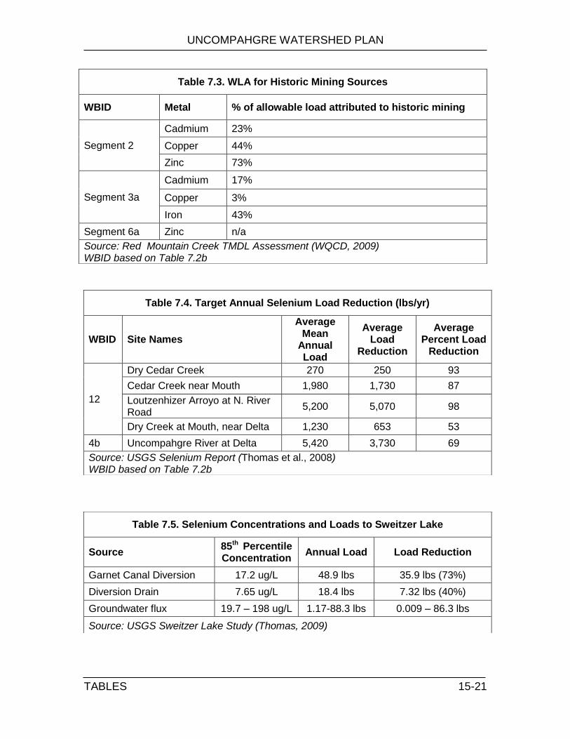
UNCOMPAHGRE WATERSHED PLAN
TABLES 15-21
Table 7.3. WLA for Historic Mining Sources
WBID Metal % of allowable load attributed to historic mining
Segment 2
Cadmium 23%
Copper 44%
Zinc 73%
Segment 3a
Cadmium 17%
Copper 3%
Iron 43%
Segment 6a Zinc n/a
Source: Red Mountain Creek TMDL Assessment (WQCD, 2009) WBID based on Table 7.2b
Table 7.4. Target Annual Selenium Load Reduction (lbs/yr)
WBID Site Names
Average Mean
Annual Load
Average Load
Reduction
Average Percent Load
Reduction
12
Dry Cedar Creek 270 250 93
Cedar Creek near Mouth 1,980 1,730 87
Loutzenhizer Arroyo at N. River Road
5,200 5,070 98
Dry Creek at Mouth, near Delta 1,230 653 53
4b Uncompahgre River at Delta 5,420 3,730 69
Source: USGS Selenium Report (Thomas et al., 2008) WBID based on Table 7.2b
Table 7.5. Selenium Concentrations and Loads to Sweitzer Lake
Source 85th Percentile Concentration
Annual Load Load Reduction
Garnet Canal Diversion 17.2 ug/L 48.9 lbs 35.9 lbs (73%)
Diversion Drain 7.65 ug/L 18.4 lbs 7.32 lbs (40%)
Groundwater flux 19.7 – 198 ug/L 1.17-88.3 lbs 0.009 – 86.3 lbs
Source: USGS Sweitzer Lake Study (Thomas, 2009)

UNCOMPAHGRE WATERSHED PLAN
TABLES 15-22
Table 7.6. Seasonal Conductivity (µS/cm) levels in the Uncompahgre River
Location High Water Irrigation Flow Base Flow
Ouray 235 395 625
Ridgway 420 565 680
Delta 1,070 1,150 1,530
Source: adapted from Tuttle and Grauch, 2009
Table 7.7. Tri-County Water Quality Assessment of Ridgway Reservoir
Parameter Sample Location Description
Iron Uncompahgre River Reservoir Outlet
River samples generally above MCL and stream standards, Reservoir Outlet had high July concentration
Aluminum Uncompahgre River Reservoir Surface Reservoir Outlet
Extremely high levels in the river, several exceedances of secondary MCL in reservoir
Manganese Uncompahgre River Samples generally exceeded MCL, always below chronic stream standard
Cadmium Uncompahgre River Reservoir Surface Reservoir Outlet
All samples were below the MCL. The Reservoir Surface and Reservoir Outlet samples exceeded the acute stream standard in April, but were below the chronic stream standard for all other samples. The River sample was always below the acute stream standard, but exceeded the chronic stream standard for April through June. The final two River samples (July and August) were below the chronic stream standard.
Dissolved and Total Organic Carbon
Uncompahgre River Reservoir Surface
Most samples above 2.0 mg/l, the level generally considered low organic water
Copper Uncompahgre River All samples above chronic and acute standards, all samples below MCL
Lead Uncompahgre River Reservoir Surface Reservoir Outlet
All Reservoir Surface and Reservoir Outlet samples below MCL. River samples were below the acute stream standard for all samples, but at or above the chronic stream standard for April through July. Reservoir Surface samples were above the chronic stream standard for April through June, but were below the standard in July and August. The Reservoir Outlet sample was above the chronic stream standard in April, but below the standard for all other months.
Alkalinity Uncompahgre River Low alkalinity in spring runoff
Total Suspended Solids
Uncompahgre River
Significant increases associated with spring runoff
Source: 2007 Tri-County Ridgway Reservoir Water Quality Study Final Report

UNCOMPAHGRE WATERSHED PLAN
TABLES 15-23
Table 9.1. Goals and Objectives
Goal Priority Pollutant/ Influence
Sources Extent Present Cause Objective
Improve water quality
High Heavy Metals
Natural mineralization Throughout the upper watershed, particularly Red Mountain Creek Basin
Natural erosion Restore waters impaired by metals Inactive mine features
Untreated tailings and waste rock piles, draining adits
High Selenium
Mancos Shale lower watershed (83,616 irrigated acres)
Deep groundwater percolation Restore waters impaired by selenium
Point Source Discharges North R-34 gravel pit WWTP discharges
Medium Salts Mancos Shale lower watershed (83,616 irrigated acres)
Deep percolation Reduce salt loads
Medium Nutrients
Agricultural runoff Below Ridgway Reservoir Overuse of fertilizer
Reduce nutrient loads
Lack of runoff controls
Stormwater runoff Entire watershed
Undersized and out-dated infrastructure
Lack of stormwater planning
Inadequate permit enforcement
Wastewater treatment Ouray and Ridgway Limited lagoon efficiency in winter weather
Medium Sediment Natural Erosion
Entire watershed Erosion Reduce sediment loads Channelization
Improve riverine ecosystem function
Medium Channel instability
Multiple Entire watershed
Land use practices Understand the factors that lead to instability and unpredictability of the river channel
Channelization
Storm events
In-stream gravel mining
Medium Development Population growth Entire watershed, especially along river corridor in Montrose
Loss of habitat Protect environmentally sensitive areas
Medium Flooding Altered hydrograph Ouray, Ouray to Ridgway, Delta
Inadequate floodplain maps
Improve flood management Accelerated snowmelt
Lack of floodplain connectivity
Medium Non-native species
Existing infestations Montrose to Delta Development in the floodplain Encourage development of
riparian buffers and new wetlands Lack of native vegetation
Improve seasonal low flows
Medium
Low seasonal flows
Priority system
Notable low flows at Pa-co-chu-puk and Olathe
Fully appropriated river
Identify long-term strategies to augment flows
Increased domestic demand Increased municipal demand
Irrigated agriculture Inefficient irrigation practices
In-channel diversions Inefficient diversion structures
Reservoir releases Conservative water management objectives

UNCOMPAHGRE WATERSHED PLAN
TABLES 15-24
Goal Priority Pollutant/ Influence
Sources Extent Present Cause Objective
Improve recreation opportunities
Medium Trespass Patchwork of private property Public – private boundaries are not well marked
Limited places for boaters to portage, picnic or pull over for safety reasons
Educate the public about rights, responsibilities and safety hazards
Medium Navigation barriers
In-channel diversion structures
6 major diversion structures Un-marked, non-navigable diversion structures that are dangerous for boaters
Create a stable stakeholder group
High Instability Lack of formal structure Entire watershed Lack of consistent leadership
Increase participation in UWP meetings
Secure funding for implementation and future watershed coordinator
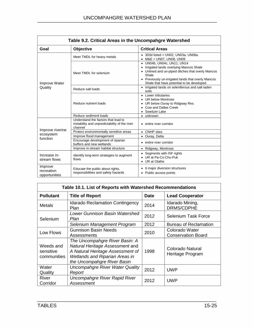
UNCOMPAHGRE WATERSHED PLAN
TABLES 15-25
Table 9.2. Critical Areas in the Uncompahgre Watershed
Goal Objective Critical Areas
Improve Water Quality
Meet TMDL for heavy metals 303d listed = UN02, UN03a, UN06a
M&E = UN07, UN08, UN09
Meet TMDL for selenium
UN04b, UN04c, UN11, UN14
Irrigated lands overlying Mancos Shale
Unlined and un-piped ditches that overly Mancos Shale
Previously un-irrigated lands that overly Mancos Shale that have potential to be developed
Reduce salt loads Irrigated lands on seleniferous and salt-laden
soils
Reduce nutrient loads
Lower tributaries
UR below Montrose
UR below Ouray to Ridgway Res.
Cow and Dallas Creek
Sweitzer Lake
Reduce sediment loads unknown
Improve riverine ecosystem function
Understand the factors that lead to instability and unpredictability of the river channel
entire river corridor
Protect environmentally sensitive areas CNHP sites
Improve flood management Ouray, Delta
Encourage development of riparian buffers and new wetlands
entire river corridor
Improve in-stream habitat structure Ridgway, Montrose
Increase in-stream flows
Identify long-term strategies to augment flows
Segments with ISF rights
UR at Pa-Co-Chu-Puk
UR at Olathe
Improve recreation opportunities
Educate the public about rights, responsibilities and safety hazards
6 major diversion structures
Public access points
Table 10.1. List of Reports with Watershed Recommendations
Pollutant Title of Report Date Lead Cooperator
Metals Idarado Reclamation Contingency Plan
2014 Idarado Mining, DRMS/CDPHE
Selenium
Lower Gunnison Basin Watershed Plan
2012 Selenium Task Force
Selenium Management Program 2012 Bureau of Reclamation
Low Flows Gunnison Basin Needs Assessments
2010 Colorado Water Conservation Board
Weeds and sensitive communities
The Uncompahgre River Basin: A Natural Heritage Assessment and A Natural Heritage Assessment of Wetlands and Riparian Areas in the Uncompahgre River Basin
1998 Colorado Natural Heritage Program
Water Quality
Uncompahgre River Water Quality Report
2012 UWP
River Corridor
Uncompahgre River Rapid River Assessment
2012 UWP

UNCOMPAHGRE WATERSHED PLAN
TABLES 15-26
Table 10.2. Target Metals Reductions
WBID Metal Description of seasonal load reductions
UN02
Cd >70% in months of March through May
Cu >70% in months of April through May
Zn 83% in the month of April
UN03a
Cd 48% - 57% in months of March through May, Sept and Oct
Cu >80% in months of October through March
Fe 72% - 82% in months of January through April
UN06a Zn High Flow: 75% reduction, Low Flow: 45% reduction
Source: Red Mountain Creek TMDL Assessment (WQCD, 2009)
Table 10.3. Target Selenium Reductions
Waterbody Annual Load Reduction
% range lbs/yr
4b: Uncompahgre River from LaSalle Road to Confluence May (61%) Jan (81%)
2,279
4c:Uncompahgre River from Confluence Park to Gunnison River
Mar (56%) Feb (82%)
2,129
12: Cedar Creek Jun (31%) Dec (90%)
1.472
12: Dry Cedar Creek Jun (52%) Dec (95%)
260
12: Loutsenhizer Arroyo May (89%) Nov (98%)
6,625
12: Montrose Arroyo Jul (80%) Jan (97%)
1,133
12: Dry Creek Dec (18%) Feb (54%)
349
Source: Lower Gunnison Basin TMDL (WQCD, 2010)

UNCOMPAHGRE WATERSHED PLAN
TABLES 15-27
Table 11.2. Water Quality Data Sources
Agency Description / Citation
WQCD
Sites 55 and 79, data from 1968 to 2007 depending on parameter.
WQCD, 2009. Use Attainability analysis Uncompahgre River.
WQCD, 2009. Total Maximum Daily Load Assessment Red Mountain Creek/Uncompahgre River, San Juan/Ouray/Montrose County, Colorado. Final Draft.
WQCD, 2009. Total Maximum Daily Load Assessment Gunnison River and Tributaries Uncompahgre River and Tributaries, Delta/Mesa/Montrose Counties, Colorado. Public Notice Draft.
CDPHE/ HAZMAT
O’Grady, M. 2005. Combined assessment analytical results report upper Uncompahgre River watershed Ouray and San Juan Counties, Colorado. Colorado Department of Public Health and the Environment, Hazardous Materials and Waste Management Division. Denver, Colorado
Mackey, Kevin. 2000. Analytical Results Report, Canyon Creek Watershed, Ouray, CO.
Price, Camille. 2001.May sediment release study from Ouray Hydro dam
DOW
River Watch Program (Mid 1990’s to 2007)
Martin, Lori. 2003-2004. CDOW. Delta irrigation ditches
Kowalski, Dan. 2009. Macroinvertebrate samples
MFG MFG. 1991. Technical Memorandum Red Mountain Creek Basin Study Flow Spring 1990 High Flow Conditions Volume I.
USGS
Four USGS sites (9146020 at Ouray, 9146200 above Ridgway Reservoir, 9147025 below Ridgway Reservoir and 9147500 at Colona)
Thomas, J.C., K.J. Leib, and J.W. Mayo. 2008. Analysis of dissolved selenium loading for selected sits in the lower Gunnison River Basin, Colorado. 1978-2005.
Runkel, Robert L., Kimball, Briant A., Walton-Day, Katherine, and Verplanck, Philip L., 2005, Geochemistry of Red Mountain Creek, Colorado, under low-flow conditions, August 2002: U.S. Geological Survey Scientific Investigations Report 2005–5101, 78 p.
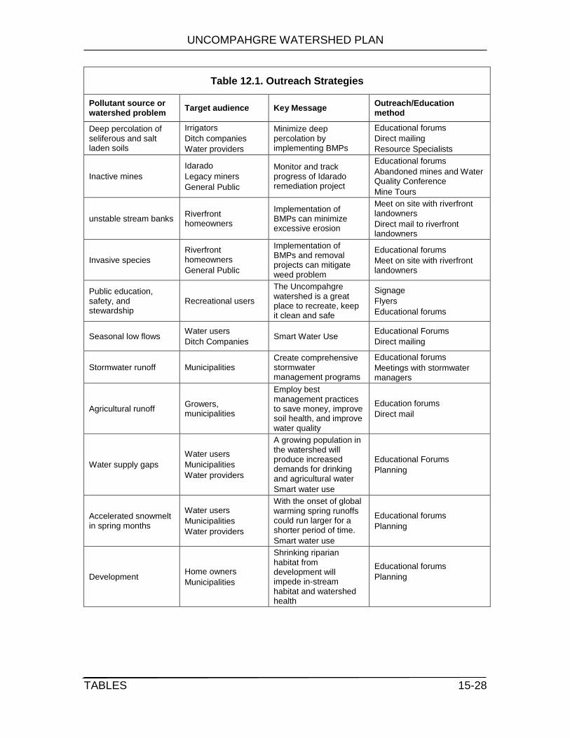
UNCOMPAHGRE WATERSHED PLAN
TABLES 15-28
Table 12.1. Outreach Strategies
Pollutant source or watershed problem
Target audience Key Message Outreach/Education method
Deep percolation of seliferous and salt laden soils
Irrigators
Ditch companies
Water providers
Minimize deep percolation by implementing BMPs
Educational forums
Direct mailing
Resource Specialists
Inactive mines
Idarado
Legacy miners
General Public
Monitor and track progress of Idarado remediation project
Educational forums
Abandoned mines and Water Quality Conference
Mine Tours
unstable stream banks Riverfront homeowners
Implementation of BMPs can minimize excessive erosion
Meet on site with riverfront landowners
Direct mail to riverfront landowners
Invasive species
Riverfront homeowners
General Public
Implementation of BMPs and removal projects can mitigate weed problem
Educational forums
Meet on site with riverfront landowners
Public education, safety, and stewardship
Recreational users
The Uncompahgre watershed is a great place to recreate, keep it clean and safe
Signage
Flyers
Educational forums
Seasonal low flows Water users
Ditch Companies Smart Water Use
Educational Forums
Direct mailing
Stormwater runoff Municipalities Create comprehensive stormwater management programs
Educational forums
Meetings with stormwater managers
Agricultural runoff Growers, municipalities
Employ best management practices to save money, improve soil health, and improve water quality
Education forums
Direct mail
Water supply gaps
Water users
Municipalities
Water providers
A growing population in the watershed will produce increased demands for drinking and agricultural water
Smart water use
Educational Forums
Planning
Accelerated snowmelt in spring months
Water users
Municipalities
Water providers
With the onset of global warming spring runoffs could run larger for a shorter period of time.
Smart water use
Educational forums
Planning
Development Home owners
Municipalities
Shrinking riparian habitat from development will impede in-stream habitat and watershed health
Educational forums
Planning

UNCOMPAHGRE WATERSHED PLAN
TABLES 15-29
Table 13.1. Methods for Evaluating Success
Objectives Methods for evaluating success
Restore waters impaired by heavy metals # BMPs installed, water quality improvement, segments removed from the 303d list
Restore waters impaired by selenium # BMPs installed, water quality improvement, segments removed from the 303d list
Reduce salt loads # BMPs installed, water quality improvement
Reduce nutrient loads # BMPs installed
Reduce sediment loads # miles restored, water quality improvement
Understand the factors that lead to instability and unpredictability of the river channel
# studies completed
Protect environmentally sensitive areas # acres protected by conservation easements # of miles free from weeds and non-native species
Improve flood management within the Uncompahgre Valley
# maps created, # meetings with local government representatives
Encourage development of riparian buffers and new wetlands
# of miles free from weeds and non-native species
Identify long-term strategies to augment flows
Winter flows below Ridgway Reservoir, summer flows at Olathe, # Wise Water Use Council meetings attended
Improve in-stream habitat structure # structures installed, fish surveys, macroinvertebrate surveys
Educate public about private rights, responsibilities and safety hazards
#signs/maps posted, reduced number of boating incidents, reduced number of trespass conflicts
Increase participation in UWP meetings # of individuals at each meeting, # meetings scheduled per year, # volunteer opportunities scheduled, # of newspaper articles
Secure funding for implementation and future watershed coordinator
# grants applied for, # of businesses approached for support, amount of funding received, successful allocation and implementation of granted money

UNCOMPAHGRE WATERSHED PLAN
FIGURES 16-1
16.0 FIGURES Figure 2.1. Location of the Uncompahgre Watershed
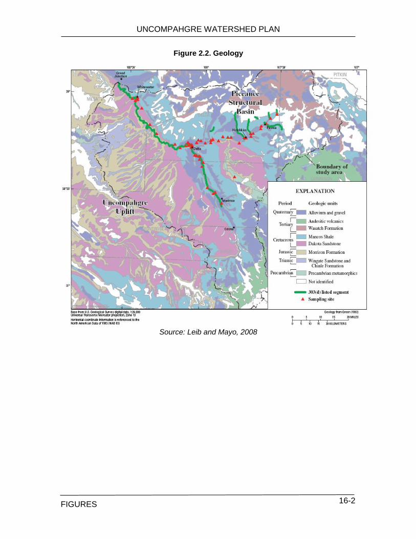
UNCOMPAHGRE WATERSHED PLAN
TABLES 16-2
Figure 2.2. Geology
Source: Leib and Mayo, 2008
FIGURES

UNCOMPAHGRE WATERSHED PLAN
TABLES 16-3
Figure 2.3. Precipitation
Source: NRCS Rapid Watershed Assessment, 2009
FIGURES
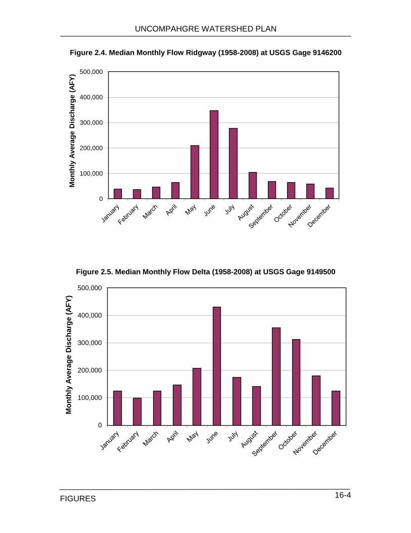
UNCOMPAHGRE WATERSHED PLAN
TABLES 16-4
Figure 2.4. Median Monthly Flow Ridgway (1958-2008) at USGS Gage 9146200
Figure 2.5. Median Monthly Flow Delta (1958-2008) at USGS Gage 9149500
0
100,000
200,000
300,000
400,000
500,000M
on
thly
Av
era
ge D
isch
arg
e (
AF
Y)
0
100,000
200,000
300,000
400,000
500,000
Mo
nth
ly A
ve
rag
e D
isch
arg
e (
AF
Y)
FIGURES

UNCOMPAHGRE WATERSHED PLAN
TABLES 16-5
Figure 2.6. Average Monthly Snowpack at Idarado Station (1981-2009)
Figure 2.7. Snowpack Profile at Idarado Station (1981-2009)
Source: SNOTEL Water Year Graph for Idarado s Station
http://www.wcc.nrcs.usda.gov/cgibin/site-wygraph-multi.pl?state=CO
0
2
4
6
8
10
12
14
Oct Nov Dec Jan Feb Mar Apr May Jun Jul Aug Sep
Sn
ow
Wate
r E
qu
lvale
nt
(in
ch
es)
FIGURES
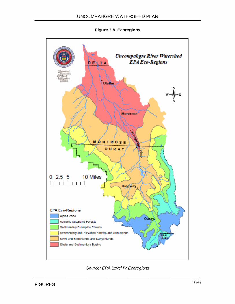
UNCOMPAHGRE WATERSHED PLAN
TABLES 16-6
Figure 2.8. Ecoregions
Source: EPA Level IV Ecoregions
FIGURES
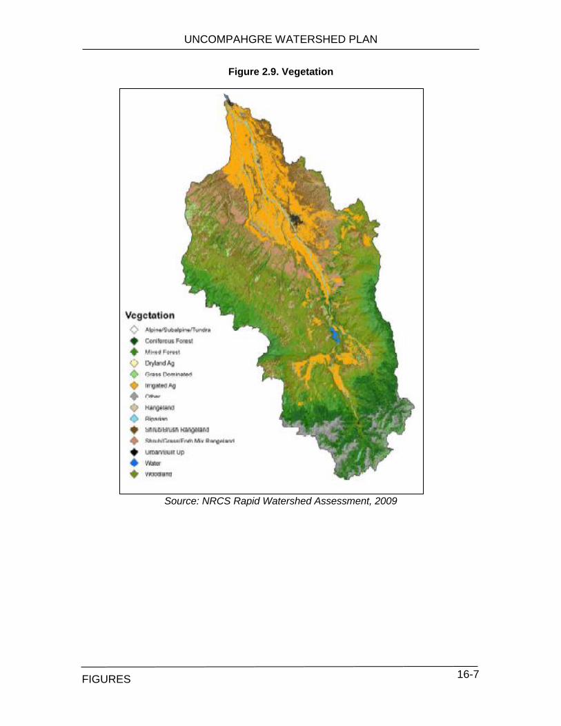
UNCOMPAHGRE WATERSHED PLAN
TABLES 16-7
Figure 2.9. Vegetation
Source: NRCS Rapid Watershed Assessment, 2009
FIGURES
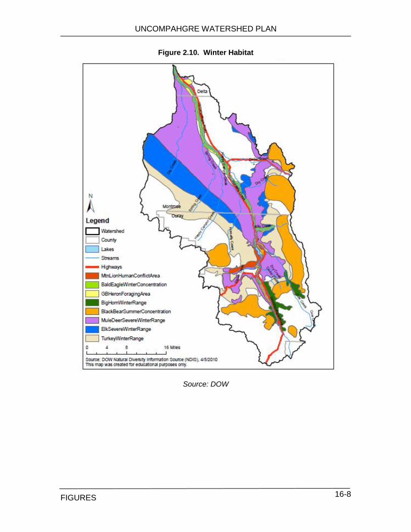
UNCOMPAHGRE WATERSHED PLAN
TABLES 16-8
Figure 2.10. Winter Habitat
Source: DOW
FIGURES

UNCOMPAHGRE WATERSHED PLAN
TABLES 16-9
Figure 2.11. Proposed Conservation Areas
Source: CNHP 1999
Figure 2.12. Map of Forest Pests and Pathogens
Source: USFS
FIGURES

UNCOMPAHGRE WATERSHED PLAN
TABLES 16-10
Figure 2.13. Landownership
Source: CoMap v7
FIGURES
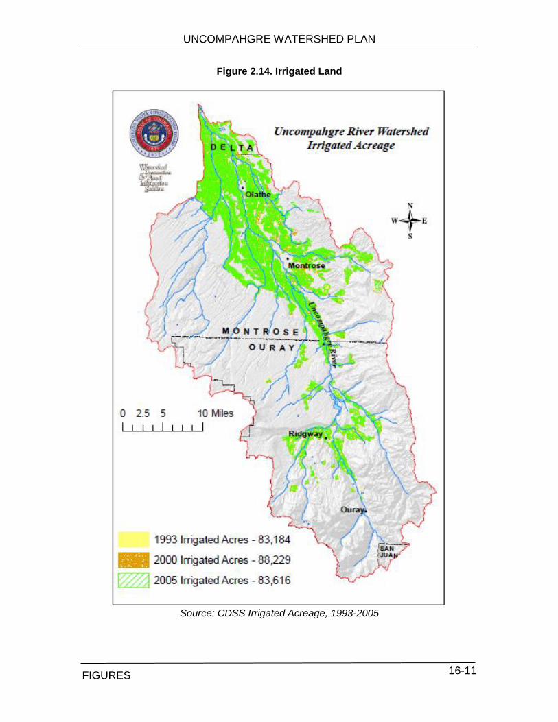
UNCOMPAHGRE WATERSHED PLAN
TABLES 16-11
Figure 2.14. Irrigated Land
Source: CDSS Irrigated Acreage, 1993-2005
FIGURES
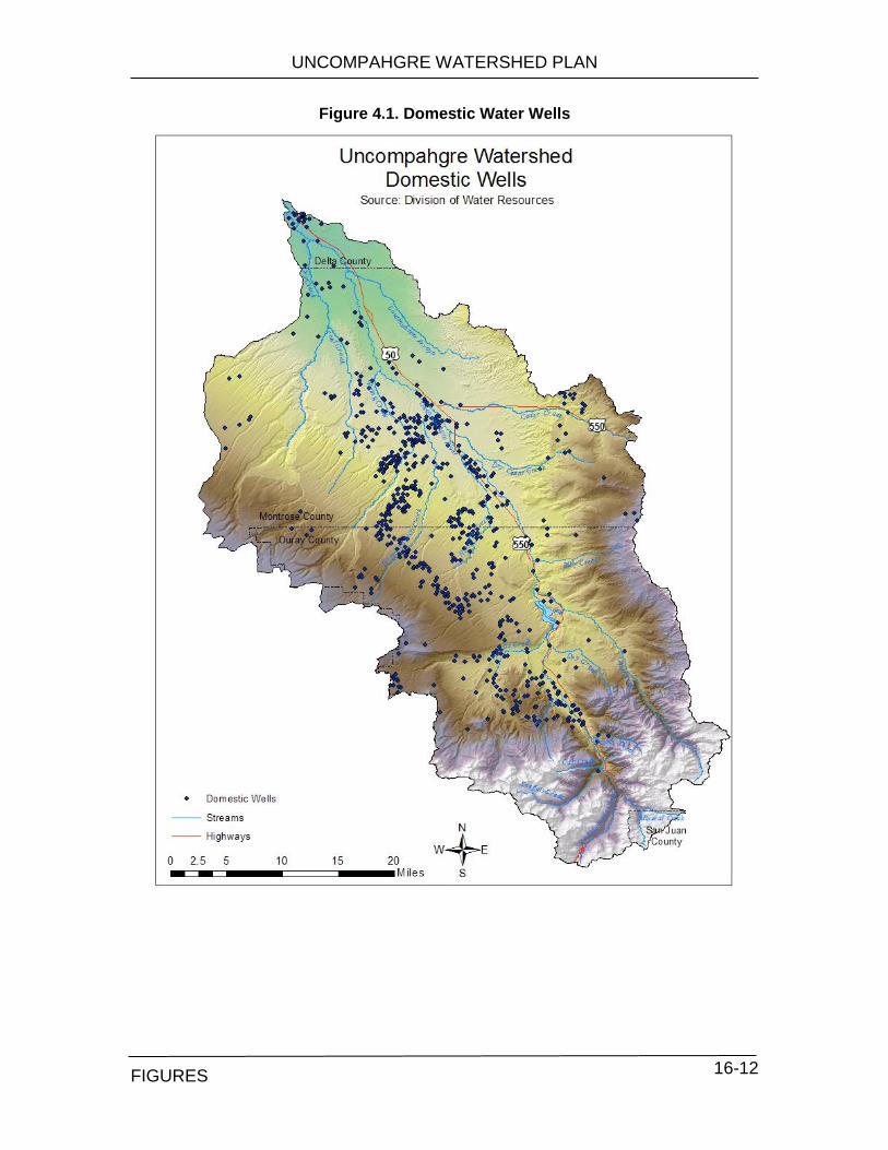
UNCOMPAHGRE WATERSHED PLAN
TABLES 16-12
Figure 4.1. Domestic Water Wells
FIGURES
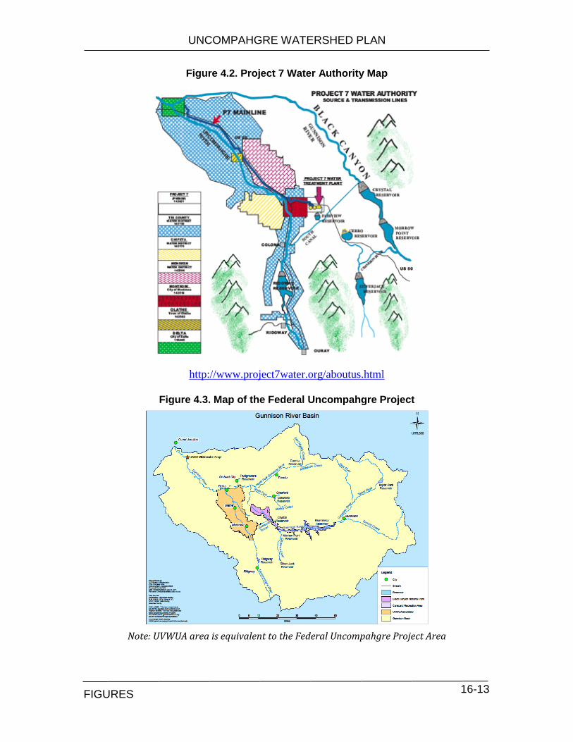
UNCOMPAHGRE WATERSHED PLAN
TABLES 16-13
Figure 4.2. Project 7 Water Authority Map
http://www.project7water.org/aboutus.html
Figure 4.3. Map of the Federal Uncompahgre Project
Note: UVWUA area is equivalent to the Federal Uncompahgre Project Area
FIGURES

UNCOMPAHGRE WATERSHED PLAN
TABLES 16-14
Figure 4.4. Location of Diversions
FIGURES

UNCOMPAHGRE WATERSHED PLAN
TABLES 16-15
Figure 6.1. Total habitat scores for 17 sites in the Uncompahgre Watershed The habitat scores (HB) are categorized into qualitative categories: poor (HB < 25), fair (HB 25-49), good
(HB 50-74), excellent (HB ≥ 75).
Figure 6.2. Feeding Functional Groups (FFG) of macroinvertebrates
at 4 sampling sites.
0
10
20
30
40
50
60
70
80
90
100Ir
on
ton
Me
mo
rial
Engi
ne
er
Pas
s
Ab
ove
Hyd
ro
Be
low
Hyd
ro
Can
yon
Cre
ek
Ou
ray
Riv
er
Par
k
KO
A
Ro
llan
s P
ark
Spir
ek
Pro
pe
rty
Pac
och
up
uk
Co
w C
ree
k
Bill
y C
ree
k
Ute
Mu
seu
m
Bal
dri
dge
Par
k
Wat
erf
ron
t
Saza
ma
Sco
re (%
)
Excellent
Good
Fair
Poor
Region 1High Gradient
Region 2Low Gradient
Region 3Low Gradient
Region 4Low Gradient
Upstream Downstream
37%
40%
12%
8%2%
c. Waterway
21%
20%
13%
38%
7%
d. Baldridge Park
25%
39%
17%
5%
15%
b. Billy Creek
41%
13%0%
21%
26%
a. Rollans Park
25%
39%
17%
5%
15%
Billy Creek
% Filterers
% Gatherers
% Scrapers
% Shredders
% Predators & Others
FIGURES

UNCOMPAHGRE WATERSHED PLAN
TABLES 16-16
Figure 6.3. Severely Braided Sections of the Uncompahgre River
FIGURES

UNCOMPAHGRE WATERSHED PLAN
TABLES 16-17
Figure 7.1a. WBID’s in the Uncompahgre Watershed after Mar. 30, 2013 re-segmentation (see Table 7.2a)
Data and map will be available March 2013
FIGURES

UNCOMPAHGRE WATERSHED PLAN
TABLES 16-18
Figure 7.1b. WBID’s in the Uncompahgre Watershed before Mar. 30, 2013 re-segmentation (see Table 7.2b)
FIGURES

UNCOMPAHGRE WATERSHED PLAN
TABLES 16-19
Figure 7.2. Impaired and Water Quality Limited Segments
FIGURES

UNCOMPAHGRE WATERSHED PLAN
TABLES 16-20
Figure 7.3. Sites sampled for water quality by Water Quality Control Division (WQCD) in 2012.
FIGURES

UNCOMPAHGRE WATERSHED PLAN
TABLES 16-21
Figure 8.1. Ridgway Reservoir Releases
Source: Bureau of Reclamation Reservoir Releases
Figure 8.2. Summer Flow Rates at Olathe
0
200
400
600
800
1,000
1,200R
ele
ase (
cfs
)
0
1
10
100
1,000
10,000
CF
S
Summer Flow Rates at Olathe Gage
2002
2005
2009
50 cfs
FIGURES
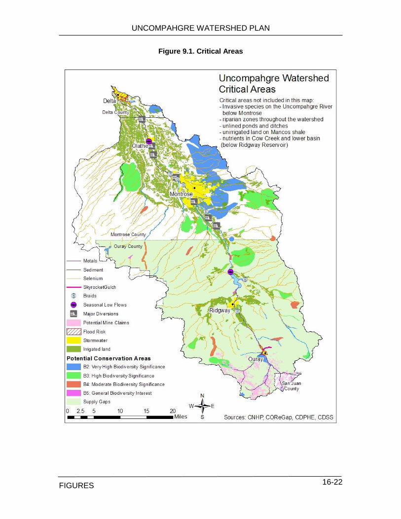
UNCOMPAHGRE WATERSHED PLAN
TABLES 16-22
Figure 9.1. Critical Areas
FIGURES
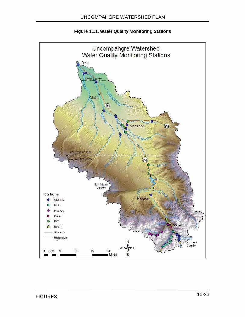
UNCOMPAHGRE WATERSHED PLAN
TABLES 16-23
Figure 11.1. Water Quality Monitoring Stations
FIGURES
APPENDIX A A
APPENDIX A Case # Name of Stream Upper Terminus Lower Terminus Amount (Date)
(CFS) Approp Date
4-84CW425 Beaver Creek Headwaters confl EF Dallas Creek 1.5 (01/01-12/31) 05/04/1984
4-84CW420 Cow Creek confl Wildhorse Creek hdgt div near Forest Service bndry 18 (04/01-07/31) 5 (08/01-03/31)
05/04/1984
4-98CW234 Dallas Creek confl E & W Forks Dallas Cr confl Ridgway Reservoir 20 (05/01-10/14) 9 (10/15-04/30)
07/13/1998
4-05CW150 Dry Creek confl E & W Forks Dry Creek hdgt Project canal & siphon 3 (03/01-03/31) 7.3 (04/01-06/14) 3 (06/15-07/31) 1.2 (08/01-02/29)
01/25/2005
4-84CW424 East Fork Dallas Creek confl Wilson Creek hdgt Doc Wade div 10 (03/1-09/30) 5 (10/1-02/29)
05/04/1984
4-05CW151 East Fork Dry Creek confl Beaver Dams Creek confl West Fork Dry Creek 1.6 (03/01-03/31) 3.6 (04/01-06/14) 1.6 (06/15-07/31) 0.6 (08/01-02/29)
01/25/2005
4-06CW167 East Fork Spring Creek headwaters confl Spring Creek 1.6 (11/01-03/31) 1.8 (4/01-10/31)
01/25/2006
4-06CW169 Middle Fork Spring Creek headwaters confl Spring Creek 3.5 (04/01-10/31) 1.5 (11/01-03/31)
01/25/2006
4-84CW422 Nate Creek headwaters confl Cow Creek 2 (01/01-12/31) 05/04/1984
4-84CW421 Owl Creek headwaters confl Cow Creek 1.5 (01/01-12/31) 05/04/1984
4-04CW163 Spring Creek confl E & M Fks Spring Creek hdgt Kenton Ditch 5.3 (04/01-06/15) 2.6 (06/16-07/31) 0.9 (08/01-03/31)
01/28/2004
4-98CW222 Uncompahgre River Highway 62 bridge confl Ridgway Res 65 (05/1-10/14) 20 (10/15-04/30)
07/13/1998
4-84CW423 West Fork Dallas Creek headwaters hdgt Burkhard Eddy div 2.5 (01/01-12/31) 05/04/1984
4-05CW155 West Fork Dry Creek confl Grays Creek confl East Fork Dry Creek 0.85 (03/01-03/31) 01/25/2005