underwater cultural heritage and seabed mining in the
TRANSCRIPT
Underwater Cultural Heritage and Seabed Mining in the
Northern Territory
with applicability to other marine industries
Strategy for Management
June 2017

Underwater Cultural Heritage and Seabed Mining in the Northern Territory: Strategy for Management
Cosmos Archaeology Pty Ltd ii
Underwater Cultural Heritage and Seabed Mining in the Northern Territory with applicability to other marine industries
Strategy for Management
Prepared for:
Heritage Branch
Department of Tourism and Culture
Northern Territory Government
An initiative under the Historic Shipwrecks Program
Department of Environment and Energy
By:
Danielle Wilkinson
Cosmos Coroneos
June 2017
Cosmos Archaeology Job number J17/10

Underwater Cultural Heritage and Seabed Mining in the Northern Territory: Strategy for Management
Cosmos Archaeology Pty Ltd iii
SUMMARY OF POLICY
FOR UNDERWATER CULTURAL HERITAGE AND SEABED MINING IN THE NORTHERN TERRITORY
This policy has been prepared to inform a review of the actual and potential impacts of seabed mining on underwater cultural heritage in the Northern Territory. This review will assist the NT Environment Protection Authority in the preparation of a report for the Minister of Environment and assist in the ongoing management of underwater cultural heritage in relation to maritime projects more generally.
This policy is derived from the following values (Section 2):
Submerged Aboriginal cultural landscapes
Aboriginal and Macassan archaeological sites
Aboriginal and Macassan shipwrecks
Historic shipwrecks Aircraft wrecks
Maritime infrastructure Unexploded Ordnance Military discard Sea dumping Abandoned pearl farms Scuttled vessels Other discard
This policy is in response to seabed mining activities with potential impacts to underwater cultural heritage values, summarised such as (Section 3):
Physical removal of seabed Relocation of dredged material Installation of temporary or permanent infrastructure Disturbance of seabed from vessel movements Discard
This policy is to be implemented by the following strategy (Section 4):
1. Desktop assessment 2. Geophysical survey 3. Site inspection 4. Significance assessment 5. Impact assessment 6. Maritime Archaeological Management Plan 7. Management and mitigation
o Post-approvals phase o Mining construction and production phase o Rehabilitation
This policy is underpinned by (Section 4.6.4):
NT Heritage Act Commonwealth Historic Shipwrecks Act United States Sunken Military Craft Act UNESCO Convention on the Protection of the Underwater Cultural Heritage (2001) Australia ICOMOS Burra Charter 2013

Underwater Cultural Heritage and Seabed Mining in the Northern Territory: Strategy for Management
Cosmos Archaeology Pty Ltd iv
TABLE OF CONTENTS Summary of policy ................................................................................................................ iii
1 Introduction ................................................................................................................... 1
1.1 Background ................................................................................................................ 11.2 Objective .................................................................................................................... 11.3 Overview of guidelines ............................................................................................... 11.4 Abbreviations and definitions ..................................................................................... 1
2 Underwater cultural heritage values ........................................................................... 2
2.1 Site types ................................................................................................................... 23 Impacts to underwater cultural heritage ..................................................................... 5
3.1 Types of damage ....................................................................................................... 53.2 Direct impacts ............................................................................................................ 53.3 Indirect impacts .......................................................................................................... 63.4 Impacts on site types ................................................................................................. 7
4 Strategies for assessment .......................................................................................... 10
4.1 Desktop assessment ................................................................................................ 104.2 Geophysical and geotechnical survey ..................................................................... 114.3 Field investigation .................................................................................................... 114.4 Significance assessment ......................................................................................... 114.5 Impact assessment .................................................................................................. 12
5 Management and mitigation ....................................................................................... 13
5.1 Maritime Archaeological Management Plan ............................................................ 135.2 Implement management and mitigation measures .................................................. 16
Annex A – Strategy guidelines ............................................................................................ 17
Annex B – Seabed mining ................................................................................................... 19
B.1 Background .............................................................................................................. 19B.2 Exploration ............................................................................................................... 19B.3 Mining ...................................................................................................................... 19B.4 Rehabilitation ........................................................................................................... 20
Annex C – Case studies ....................................................................................................... 21
C.1 INPEX Ichthys Gas Project, Darwin Harbour, NT .................................................... 21C.2 East Point Sewage Outfall, Darwin Harbour, NT ..................................................... 22C.3 Channel Deepening Project, Port Phillip Bay, Melbourne ........................................ 24C.4 Hong Kong SAR ....................................................................................................... 25C.5 London Gateway Project, River Thames, Essex, England ...................................... 27C.6 Southampton Approach Channel Dredge, Hampshire, England ............................. 28
Annex D – Geophysical survey techniques ....................................................................... 30
Annex E – Legislation and regulations .............................................................................. 31
E.1 Commonwealth legislation ....................................................................................... 31E.2 Northern Territory legislation .................................................................................... 32E.3 International legislation ............................................................................................ 33E.4 Guidelines ................................................................................................................ 33
References ............................................................................................................................ 35
Underwater Cultural Heritage and Seabed Mining in the Northern Territory: Strategy for Management
Cosmos Archaeology Pty Ltd 1
1 INTRODUCTION
1.1 Background The Northern Territory (NT) Environment Protection Authority (EPA) is preparing a report for the Minister for Environment and Natural resources to inform a review of the actual and potential impacts of seabed mining in the NT. The report will address underwater cultural heritage values, impact on those values and impact management.
The Heritage Branch of the Department of Tourism and Culture (DTC) works closely with the NT EPA to mitigate impacts to the historic environment. DTC have engaged Cosmos Archaeology to prepare guidelines that identify impacts on underwater cultural heritage values that may result from seabed mining, provide strategies for the assessment of seabed mining projects as well as strategies for the management and mitigation of impacts.
1.2 Objective The objective of these guidelines is:
To address impacts on underwater cultural heritage values that may result from activities associated with seabed mining and other marine industries in the NT and provide a strategy to manage these potential risks.
1.3 Overview of guidelines Section 2 provides an overview of the types of underwater cultural heritage values in NT waters and intertidal zone that should be considered when preparing the strategy for seabed mining. Impacts to underwater cultural heritage values as a result of seabed mining activities are summarised in Section 3. Strategies for the assessment and management of these impacts is covered in Section 4, and includes a number of mitigation measures that may be implemented to reduce the impact.
Annex A is designed to be used by seabed mining companies as an overview procedure to guide the management of impacts to underwater cultural heritage values.
1.4 Abbreviations and definitions The following abbreviations are used in these guidelines:
CLB Continuous-line bucket system TSB Territorial Sea Baseline
HSA Historic Shipwrecks Act UXO Unexploded Ordnance
NT Northern Territory WWII World War Two
ROV Remotely Operated Vehicle
The following definitions are used throughout these guidelines:
Seabed mining is defined as the commercial recovery of minerals at the surface or below the seabed. This includes the exploration and mining of a ‘mineral’ or ‘extractive mineral’ as defined in the NT Mineral Titles Act but does not include oil and gas recovery.
Northern Territory (NT) waters is defined as all coastal waters of the NT, as defined under the Commonwealth Coastal Waters (Northern Territory Powers) Act 1980. ‘Coastal waters’ refers to the belt of water between the limits of the Northern Territory and a line three nautical miles seaward of the Territorial Sea Baseline (TSB). The TSB normally corresponds with the low water line.1
1 Geoscience Australia, Australian Government, Maritime Boundary Definitions, available http://www.ga.gov.au/scientific-topics/marine/jurisdiction/maritime-boundary-definitions, accessed 18 May 2017.
Underwater Cultural Heritage and Seabed Mining in the Northern Territory: Strategy for Management
Cosmos Archaeology Pty Ltd 2
2 UNDERWATER CULTURAL HERITAGE VALUES
A number of underwater cultural heritage values exist within the waters and intertidal zone of the NT. These include known site types, such as those listed as items on statutory heritage databases, as well as those that have the potential to exist within the marine environment but are yet largely unidentified. The site types are associated with various cultural activities that occurred within the waters and intertidal zone of the NT including:
Maritime exploration; Maritime transport and trade; Exploitation of resources; Construction of infrastructure; Construction of military defences; Warfare during World War Two (WWII); and, Sea dumping.
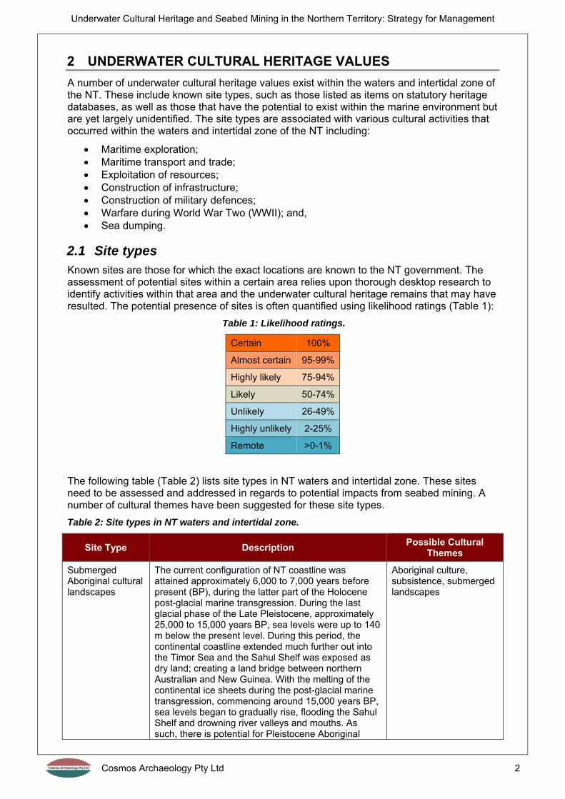
2.1 Site types Known sites are those for which the exact locations are known to the NT government. The assessment of potential sites within a certain area relies upon thorough desktop research to identify activities within that area and the underwater cultural heritage remains that may have resulted. The potential presence of sites is often quantified using likelihood ratings (Table 1):
Table 1: Likelihood ratings.
Certain 100%
Almost certain 95-99%
Highly likely 75-94%
Likely 50-74%
Unlikely 26-49%
Highly unlikely 2-25%
Remote >0-1%
The following table (Table 2) lists site types in NT waters and intertidal zone. These sites need to be assessed and addressed in regards to potential impacts from seabed mining. A number of cultural themes have been suggested for these site types.
Table 2: Site types in NT waters and intertidal zone.
Site Type Description Possible Cultural
Themes
Submerged Aboriginal cultural landscapes
The current configuration of NT coastline was attained approximately 6,000 to 7,000 years before present (BP), during the latter part of the Holocene post-glacial marine transgression. During the last glacial phase of the Late Pleistocene, approximately 25,000 to 15,000 years BP, sea levels were up to 140 m below the present level. During this period, the continental coastline extended much further out into the Timor Sea and the Sahul Shelf was exposed as dry land; creating a land bridge between northern Australian and New Guinea. With the melting of the continental ice sheets during the post-glacial marine transgression, commencing around 15,000 years BP, sea levels began to gradually rise, flooding the Sahul Shelf and drowning river valleys and mouths. As such, there is potential for Pleistocene Aboriginal
Aboriginal culture, subsistence, submerged landscapes

Underwater Cultural Heritage and Seabed Mining in the Northern Territory: Strategy for Management
Cosmos Archaeology Pty Ltd 3
Site Type Description Possible Cultural
Themes
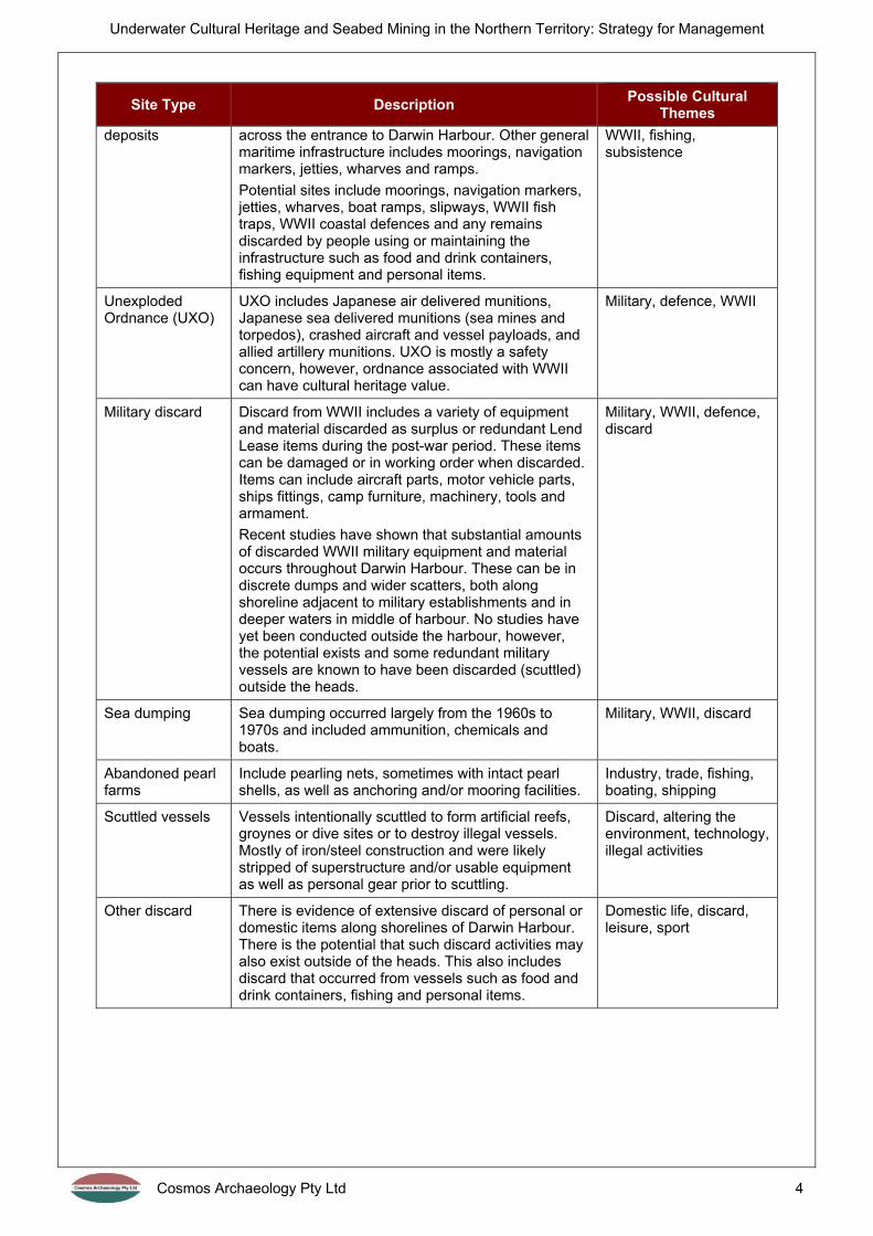
archaeological sites and deposits to survive as submerged cultural landscapes beneath Holocene marine sediments. Such site types could include stone artefact scatters, midden deposits, quarry sites, grinding grooves, stone arrangements, rick art and human burials. Based on patterns identified in the terrestrial archaeological record regarding Aboriginal land use and resource exploitation, submerged cultural sites are most likely to be concentrated around Pleistocene riverine and coastal landscapes. However, the occurrence, survival and patterning of Pleistocene sites has been subject to only very limited archaeological investigation in Australia.
Aboriginal and Macassan archaeological sites
Known sites include stone fish traps, weirs and stone lines. Additional potential sites are often concentrated around the mouths of rivers and creeks.
Aboriginal culture, Macassan culture, subsistence, technology, fishing, death, tradition
Aboriginal and Macassan shipwrecks
Aboriginal vessels, such as dugout canoes, have a higher potential close to the coastline and fringes of mangrove landscapes.
Both archaeological and documentary evidence exists of Macassan visitation to the north coast of the NT throughout the 18th to 19th centuries, particularly along the coastline from Coburg Peninsula to south-east Arnhem Land, primarily in search of sea cucumber / trepang (bêche-de-mer). Historical accounts indicate that substantial numbers of Macassan praus or perahus (timber multi-hulled sailing vessels) were wrecked along the NT coastline from 1750 to 1906. Whilst some artefacts believed to be associated with Macassan vessels have been found, no shipwreck sites have yet been located.
Aboriginal culture, Macassan culture, technology, fishing, subsistence
Historic shipwrecks and associated deposits
Known shipwrecks range from small recreational or private vessels to large cargo steamships. The vessels can be of timber or iron/steel. Shipwrecks also include military craft such as warships, submarines and potential ‘graves of the war dead’. Most shipwrecks in NT are associated with large events such as cyclones or WWII.
There are also numerous vessels known from historic records to have been lost in NT waters but which are yet to be located. These range from small 19th century pearling luggers and sailing vessels to large cargo traders and naval vessels lost during WWII.
Boating, shipping, recreation, transport, trade, technology, industry, military, catastrophe, WWII, ‘graves of the war dead’
Aircraft wrecks Known aircraft wrecks are largely associated with WWII; either wrecking during WWII or in the immediate period after. Aircraft can include fighter planes, bombers and transport aircraft.
There are also numerous aircraft known to have been lost in NT waters, many of which have yet to be located. Most are associated with WWII, including both Allied and Japanese aircraft, but also a small number of post-war aircraft losses.
WWII, war graves, military, technology
Maritime infrastructure and associated
Specific known infrastructure includes undersea telegraph cables, such as that first laid in the 1870s from Java to Darwin, as well as the WWII anti-submarine boom net and indicator loops that lie
Technology, shipping, boating, recreation, transport, trade, technology, industry,
Underwater Cultural Heritage and Seabed Mining in the Northern Territory: Strategy for Management
Cosmos Archaeology Pty Ltd 4
Site Type Description Possible Cultural
Themes
deposits across the entrance to Darwin Harbour. Other general maritime infrastructure includes moorings, navigation markers, jetties, wharves and ramps.
Potential sites include moorings, navigation markers, jetties, wharves, boat ramps, slipways, WWII fish traps, WWII coastal defences and any remains discarded by people using or maintaining the infrastructure such as food and drink containers, fishing equipment and personal items.
WWII, fishing, subsistence
Unexploded Ordnance (UXO)
UXO includes Japanese air delivered munitions, Japanese sea delivered munitions (sea mines and torpedos), crashed aircraft and vessel payloads, and allied artillery munitions. UXO is mostly a safety concern, however, ordnance associated with WWII can have cultural heritage value.
Military, defence, WWII
Military discard Discard from WWII includes a variety of equipment and material discarded as surplus or redundant Lend Lease items during the post-war period. These items can be damaged or in working order when discarded. Items can include aircraft parts, motor vehicle parts, ships fittings, camp furniture, machinery, tools and armament.
Recent studies have shown that substantial amounts of discarded WWII military equipment and material occurs throughout Darwin Harbour. These can be in discrete dumps and wider scatters, both along shoreline adjacent to military establishments and in deeper waters in middle of harbour. No studies have yet been conducted outside the harbour, however, the potential exists and some redundant military vessels are known to have been discarded (scuttled) outside the heads.
Military, WWII, defence, discard
Sea dumping Sea dumping occurred largely from the 1960s to 1970s and included ammunition, chemicals and boats.
Military, WWII, discard
Abandoned pearl farms
Include pearling nets, sometimes with intact pearl shells, as well as anchoring and/or mooring facilities.
Industry, trade, fishing, boating, shipping
Scuttled vessels Vessels intentionally scuttled to form artificial reefs, groynes or dive sites or to destroy illegal vessels. Mostly of iron/steel construction and were likely stripped of superstructure and/or usable equipment as well as personal gear prior to scuttling.
Discard, altering the environment, technology, illegal activities
Other discard There is evidence of extensive discard of personal or domestic items along shorelines of Darwin Harbour. There is the potential that such discard activities may also exist outside of the heads. This also includes discard that occurred from vessels such as food and drink containers, fishing and personal items.
Domestic life, discard, leisure, sport
Underwater Cultural Heritage and Seabed Mining in the Northern Territory: Strategy for Management
Cosmos Archaeology Pty Ltd 5
3 IMPACTS TO UNDERWATER CULTURAL HERITAGE
Seabed mining and any other developments or constructions that impact the seabed may also impact, directly or indirectly, underwater cultural heritage values. If the impact is damage or destruction of an item or its value, it is considered an adverse or negative impact. If the impact provides additional protection to an item or its value, such as by burial or the identification of valuable information, then the impact is considered beneficial or positive.
3.1 Types of damage Damage to underwater cultural heritage sites is categorised as mechanical, chemical or biological:
Mechanical damage occurs when the physical integrity of the site is affected. Enhanced mechanical damage can arise from direct mining activities as well as changed seabed topography. The latter could lead to increases in tidal flows, average wave heights and the increased exposure of sites due to sediment erosion.
Chemical damage relates primarily to the corrosion of the metal components of a site. Changes in pH levels, salinity, light levels (heat) and water movement can dramatically increase electrochemical (corrosion) activity for metal components immersed in seawater.
Biological damage occurs where organic materials, such as wreck timbers, are exposed to biological organisms such as marine borers and bacteria, and in some cases vegetation. Increased biological damage will occur if buried sites, or partially exposed sites, are further exposed due to sediment erosion. In some cases biological coverage over iron objects has a beneficial effect for long term survival.
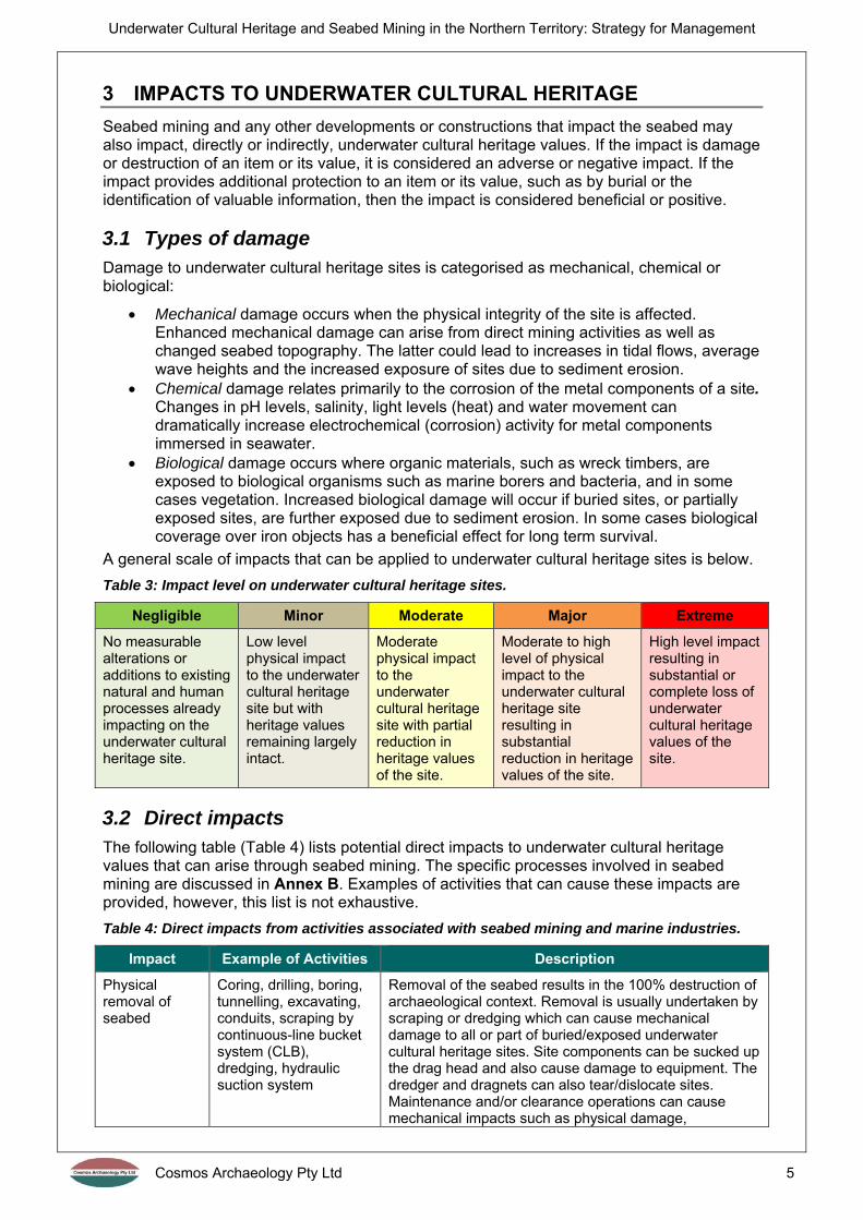
A general scale of impacts that can be applied to underwater cultural heritage sites is below.
Table 3: Impact level on underwater cultural heritage sites.
Negligible Minor Moderate Major Extreme
No measurable alterations or additions to existing natural and human processes already impacting on the underwater cultural heritage site.
Low level physical impact to the underwater cultural heritage site but with heritage values remaining largely intact.
Moderate physical impact to the underwater cultural heritage site with partial reduction in heritage values of the site.
Moderate to high level of physical impact to the underwater cultural heritage site resulting in substantial reduction in heritage values of the site.
High level impact resulting in substantial or complete loss of underwater cultural heritage values of the site.
3.2 Direct impacts The following table (Table 4) lists potential direct impacts to underwater cultural heritage values that can arise through seabed mining. The specific processes involved in seabed mining are discussed in Annex B. Examples of activities that can cause these impacts are provided, however, this list is not exhaustive.
Table 4: Direct impacts from activities associated with seabed mining and marine industries.
Impact Example of Activities Description
Physical removal of seabed
Coring, drilling, boring, tunnelling, excavating, conduits, scraping by continuous-line bucket system (CLB), dredging, hydraulic suction system
Removal of the seabed results in the 100% destruction of archaeological context. Removal is usually undertaken by scraping or dredging which can cause mechanical damage to all or part of buried/exposed underwater cultural heritage sites. Site components can be sucked up the drag head and also cause damage to equipment. The dredger and dragnets can also tear/dislocate sites. Maintenance and/or clearance operations can cause mechanical impacts such as physical damage,

Underwater Cultural Heritage and Seabed Mining in the Northern Territory: Strategy for Management
Cosmos Archaeology Pty Ltd 6
Impact Example of Activities Description
disturbance or removal of cultural material as well as increasing chemical and biological processes.
Relocation of dredged material
Land reclamation, beach replenishment, sediment dumping, seabed mine rehabilitation
Spoil from dredging is often dumped at nominated locations away from the work area. Underwater cultural heritage sites may be located in this area. Burial of sites with dredged material causes restricted access to the site which can be seen as a negative impact. The same applies to dumping in inter-tidal areas such as beaches or for land reclamation. However, burial can substantially decrease mechanical chemical and biological processes, leading to better preservation of the site.
Installation of temporary or permanent infrastructure
Piling, construction of harbour walls / sea protection, coffer dams, jack-up barges
Structures could range from single piles for navigation or mooring to groynes or marinas. The footprint of any structures may cause physical and mechanical damage to underwater cultural heritage sites on or within the seabed or intertidal area as well as deformation of the surrounding seabed deposits.
Disturbance of seabed from vessel movements
Vessel propeller jet scour, vessel wake, dynamic positioning, anchoring, tilting spuds, potential vessel groundings
Work vessels in shallow waters can create significant scour trenches which can severely impact underwater cultural heritage sites through mechanical damage and exposure to chemical and biological damage.
Work vessels moving to and from work sites can generate wakes that would disturb archaeological sites in shallow waters.
Anchoring, tilting spuds and grounding can cause mechanical damage to sites as a result of direct contact. Anchoring can also tear/dislocate sites and even result in unexpected retrieval of material caught on the anchor.
Discard Relocating obstructions Similar to dumping of spoil, the nominated location for discarded and/or relocated items and obstructions may be on top of underwater cultural heritage sites. The obstruction may also have cultural value and suffer mechanical damage by relocation as well as the 100% destruction of its context.
3.3 Indirect impacts The following table (Table 5) lists potential indirect impacts to underwater cultural heritage values that can arise through seabed mining. Examples of activities are provided, however, this list is not exhaustive.
Table 5: Indirect impacts from activities associated with seabed mining and marine industries.
Impact Example of Activities Description
Sediment erosion
Increased scour around underwater cultural heritage sites as a result of the removal and deposition of sediments and/or the installation of infrastructure.
Loss of sediment from the seabed may result in increased exposure of underwater archaeological sites and some buried sites may become exposed. Exposure leads to increased chemical and biological damage. In the intertidal zone, erosion can remove sediments protecting coastal sites and directly erode the fabric of the sites themselves. Erosion at the base of cliffs may also contribute to cliff de-stabilisation until they become a threat to sites on clifftops and at sea level.

Underwater Cultural Heritage and Seabed Mining in the Northern Territory: Strategy for Management
Cosmos Archaeology Pty Ltd 7
Impact Example of Activities Description
Sediment accretion
Increased natural accretion around underwater cultural heritage sites as a result of the removal and deposition of sediments and/or the installation of infrastructure.
The accretion of sediments around and over underwater cultural heritage sites is generally a positive impact by reducing chemical and biological damage. However, accretion can have a negative impact by covering sites and thus rendering them invisible and hence more susceptible to accidental mechanical damage as well as inaccessible to the public and researchers.
Alteration in hydrodynamics
Resulting from the removal and deposition of sediments and/or the installation of infrastructure.
Changes in physical processes beyond the range of natural variation can alter the site formation process of a site by causing erosion, accretion, mechanical movement of the site, or by introducing new chemical and/or biological processes.
3.4 Impacts on site types Impacts to site types depend on a number of factors such as material composition, size, age, and location, depth of burial / degree of exposure and seabed characteristics. The following table (Table 6) describes potential impacts to site types that can arise through seabed mining and other marine industries.
Table 6: Potential impacts to site types.
Site Type Potential Impact
Aboriginal and Macassan submerged landscapes, archaeological sites and shipwrecks
Aboriginal and Macassan sites of organic materials (such as shell middens, faunal remains, human burials, pigment rock art, some fish traps and shipwrecks) have a higher chance of survival when buried by sediments.
Any direct impacts to organic materials would have a major destructive effect through direct mechanical damage but also increasing exposure to additional mechanical, chemical and biological processes that they have been protected from. Erosion would have the same effect. Sediment accretion would have a positive impact by further burying and protecting these sites.
Non-organic sites (such as rock engravings, grinding grooves, stone artefacts, rock outcrop quarries and stone fish traps) would have a higher chance of survival in low energy environments where rapid water movement cannot abrade diagnostic features on the rock surface or dislocate scatters.
All non-organic sites would be vulnerable to direct impacts, however, indirect impacts causing an alteration to these environments would also be a prime concern.
Historic shipwrecks and associated deposits
Physical removal of the seabed is a major destructive impact in the case of shipwrecks and associated deposits.
Shipwrecks of iron/steel construction would likely impede any marine developments and need to be removed or relocated prior to works. The removal of a shipwreck from its context destroys archaeological evidence, plus removal, if done incorrectly, can cause significant damage to the wreck itself.
Timber wrecks, which may not be considered an obstacle, and shipwreck-related deposits would be completely destroyed by removal of the seabed or if located within the footprint of a temporary or permanent structure.
As wrecks are typically located on and/or are shallowly buried in the seabed, they are particularly vulnerable to propeller jet scour, anchor dragging, anchoring, erosion and accretion.
All of these direct and indirect impacts can have a negative impact by breaking up or scrambling the wreck site.
Accretion can have a positive impact by burying and protecting remains, however, it would also prevent access for recording and make it vulnerable to accidental damage.

Underwater Cultural Heritage and Seabed Mining in the Northern Territory: Strategy for Management
Cosmos Archaeology Pty Ltd 8
Site Type Potential Impact
Aircraft wrecks
Aircraft wrecks are composed of light, thin metallic skins and frames with large heavy components such as engines and any munitions.
Major destructive impacts can be caused by removal of the seabed.
Aircraft wrecks are typically located on and/or are shallowly buried in the seabed and are particularly vulnerable to propeller jet scour, anchor dragging, anchoring, erosion and accretion – more so than shipwrecks due to their aero-dynamic qualities which increase the risk of the site being dislocated and scattered in high energy environments.
All of these direct and indirect impacts can have a negative impact by breaking up or scrambling the wreck site.
Accretion can have a positive impact by burying and protecting remains, however, it would also prevent access for recording and make it vulnerable to accidental damage.
Maritime infrastructure and associated deposits
The major impacts to maritime heritage infrastructure and associated deposits is the physical removal of the seabed. Irrelevant of the method of removal, it would cause 100% destruction of the archaeological context.
It is possible that the footprint seabed structures may overlap with areas of heritage remains. Often structures will only cause partial destruction and can be mitigated. A similar impact can be caused by anchoring and tilting spuds.
Erosion can remove sediments that have been protecting intertidal and submerged sites, which can directly erode the archaeological material.
Accretion can have a positive impact by burying and protecting infrastructure and deposits. It can also have a negative impact by hiding sites and making them more susceptible to accidental damage, as well as preventing access for recording.
Unexploded Ordnance (UXO)
While UXO can have cultural value, the main concern is for safety. UXO safety protocols should be followed for any type marine development in order to avoid impact or to relocate/detonate UXO safely.
The loss of cultural material can be mitigated by recording the location and type of UXO to be included as part of the reporting by the archaeologist.
Military discard
These cultural remains can be impacted by removal of the seabed and the installation of infrastructure if they cause direct damage to the items.
Some types of discard may impede marine developments and need to be removed or relocated prior to works.
In most cases, the solid nature and inherent contextual displacement of military discard means that impacts caused by seabed disturbances will be low.
Accretion would have a positive impact by burying and conserving the items.
Sea dumping Sea dumps can be impacted by removal of the seabed and the installation of infrastructure if they cause direct damage to the items.
Dumps are usually formed of piles or scatters of large solid containers, such as 44-gallon drums, and as such may impede marine developments and need to be removed or relocated prior to works.
In most cases, the solid nature and inherent contextual displacement of sea dumps means that impacts caused by seabed disturbances will be low.
Accretion would have a positive impact by burying and conserving the dumped items.
Abandoned pearl farms
Remains from abandoned pearl farms are typically large and solid, including mooring blocks, anchors, chains and pearling panels, that would likely impede marine developments and may need to be removed or relocated prior to works.
Pearl farms are largely uniform in their design and construction, hence the destruction of archaeological context is a minor impact.
Seabed disturbances would also have minimal impact to the solid remains.

Underwater Cultural Heritage and Seabed Mining in the Northern Territory: Strategy for Management
Cosmos Archaeology Pty Ltd 9
Site Type Potential Impact
Scuttled vessels
Scuttled vessels of iron/steel construction would likely impede marine developments and may need to be removed or relocated prior to works. The removal of a scuttled vessel from its context may destroy archaeological evidence, plus incorrect removal can cause damage to the wreck itself.
Scuttled vessels have less archaeological potential in contrast to shipwrecks, however, it should not be assumed that they have none.
As scuttled vessels are typically located on and/or are shallowly buried in the seabed, they are particularly vulnerable to propeller jet scour, anchor dragging, anchoring, erosion and accretion.
All of these direct and indirect impacts can have a negative impact by breaking up or scrambling the site.
Accretion can have a positive impact by burying and protecting remains, however, it would also prevent access for recording and make it vulnerable to accidental damage.
Other discard General discard can be situated near the surface or buried within sediment. The depth of burial largely depends on the rate of sedimentation in the area.
Discard can include large solid items, such as anchors, or small delicate personal items, such as pieces of clothing.
Impacts to the seabed can result in different types of damage in varying severity for different types of items. Generally, any impact to the seabed is considered destructive for discarded material.
Removal of the seabed would cause complete destruction.
Propeller jet scour, the installation of temporary or permanent seabed structures, anchoring and erosion would all impact the seabed and discarded items in varying degrees and extents.
In the case of these items, accretion is generally a good impact for burying and protecting items.

Underwater Cultural Heritage and Seabed Mining in the Northern Territory: Strategy for Management
Cosmos Archaeology Pty Ltd 10
4 STRATEGIES FOR ASSESSMENT
There are a number of stages involved in assessing underwater cultural heritage sites and values in response to a proposed development. These stages involve identifying key underwater cultural heritage values early in the development design process, thus avoiding delays. The potential impacts are also identified early in the development design process so that mitigation measures can be determined that are appropriate for the management of the cultural significance of identified sites.
However, not all projects may be required to undergo the full assessment phase. An initial pre-assessment review of all projects should be first conducted by the NT Heritage Branch. This review would look at the project and assess factors such as the location and scale of the project and what previous archaeological information is known about the area. For this to be undertaken, the proponent is obliged to provide sufficient information regarding the proposed project including an accurate footprint of the project and all associated works. The NT Heritage Branch would then determine if the proponent will need to engage a suitably qualified maritime archaeologist to commence the assessment process.
In largely chronological order, the stages of assessment are as follows:
1. Desktop assessment; 2. Geophysical survey(s); 3. Field investigation(s); 4. Significance assessment(s); 5. Heritage impact assessment; 6. Maritime Archaeological Management Plan; and, 7. Implementing management and mitigation measures.
Examples of the assessment and management of underwater cultural heritage resources in developments around Australia and internationally have been provided in Annex C.
4.1 Desktop assessment The main objective of the desktop assessment is to use existing information to establish a baseline of the potential for underwater cultural heritage sites. This includes identification of both known sites and potential sites. The assessment must be prepared by a suitably qualified maritime archaeologist and involves:
A review of statutory and non-statutory heritage registers for known Aboriginal, Macassan and historic underwater cultural heritage sites;
A review of existing environmental information regarding current and prehistoric landscapes within the study area;
A review of relevant archaeological studies that may contribute information towards predictive modelling of prehistoric land use patterns;
A review of relevant historic sources that may document the presence of underwater cultural heritage sites within the study area that are not already known;
A review of information relating to potential post-depositional disturbance, including previous mining, dredging and related activities;
A preliminary predictive statement about the likely presence of Aboriginal, Macassan and historic underwater cultural heritage sites to determine those areas that have higher and lower likelihoods of containing sites.
A review of legislative requirements and/or constraints associated with impacting and managing identified underwater cultural heritage remains; and,
Providing recommendations for further investigations, such as field surveys, and/or management and mitigation measures.
Underwater Cultural Heritage and Seabed Mining in the Northern Territory: Strategy for Management
Cosmos Archaeology Pty Ltd 11
4.2 Geophysical and geotechnical survey Geophysical surveying techniques make it possible to map the seabed and identify anomalies. The survey program undertaken for a specific development should be designed while taking into consideration archaeological objectives and with input from the maritime archaeologist so that the data is suitable for archaeological assessment. Different possible techniques are summarised in Annex D.
The resulting geophysical survey data should be interrogated by a suitably qualified maritime archaeologist for anomalies that may be of cultural significance. From this, a target list of anomalies would be generated and prioritised for further investigation. The prioritisation would be based on:
Findings of the desktop assessment; Potential site identification; Degree of confidence of the site identification; Potential severity of impact to the site; and, Ability to access the site.
Geotechnical surveys, including the collection of geological cores / bores and grab samples, can also contribute to a greater understanding of the potential for underwater cultural heritage sites, particularly prehistoric sites. These surveys should be designed to address archaeological objectives and with input from a suitably qualified maritime, Aboriginal or geo-archaeologist, who should then also interrogate the survey data.
4.3 Field investigation Field investigations are dependent upon the findings of the desktop assessment and geophysical surveys. If potential underwater cultural heritage sites were previously identified by these methods, it may be considered necessary to supplement the survey data with inspections. This may involve diving or, where the conditions are hazardous and/or deep, use of remotely operated vehicles (ROV). In intertidal areas it may also involve a terrestrial inspection undertaken at low tide. Field investigations can also be used to survey areas that could not be accessed by geophysical survey equipment – such as areas where the water depth was insufficient to allow vessel access.
Dive inspections are carried out under Australian Standard 2299 and usually occupational scientific dive operations. Apart from locating, identifying and assessing the significance of targets selected from remote sensing data, the dive inspections can also involve sampling the seabed conditions and what cultural material may be present by undertaking survey transects across study areas. This can be particularly informative as some materials – for example, glass and ceramic artefacts lying on a rocky seafloor – are not currently detectable with available remote sensing techniques and can only be identified by a diver on site.
4.4 Significance assessment Identified sites are not all of equal cultural value. The degree of value for individual sites or site types is determined by assessing significance. This must be undertaken by a qualified maritime archaeologist and follow heritage guidelines. The following table provides an outline of degrees of significance (Table 7).

Underwater Cultural Heritage and Seabed Mining in the Northern Territory: Strategy for Management
Cosmos Archaeology Pty Ltd 12
Table 7: Criteria for cultural significance.
Minimal Low Moderate High Exceptional
A ubiquitous object or site type, usually of recent manufacture, that provides little new information to the understanding of the development of the NT.
A common object or site type in a poor to fragmentary state of integrity that contributes to the understanding of the development of the NT.
An object or site in a poor state of preservation that provides some insight on the development of the NT.
A rare object or site type in a relatively good state of preservation that provides a new insight on the development of the NT.
A rare or unique object or site in a relatively good state of preservation that provides an irreplaceable insight on the development of NT.
4.5 Impact assessment The findings of all the previous stages are assessed by a suitably qualified maritime archaeologist and culminate in a heritage report. The main purpose of this report is to assess the level of impact upon the cultural significance of sites and determine proportionate mitigation measures. The report will contain the following:
Results of desktop research and analysis; Results of the geophysical survey(s); Results of the field investigation(s); List of identified and potential underwater cultural heritage sites; Significance assessments of identified and potential underwater cultural heritage
sites; Impact assessments of identified and potential underwater cultural heritage sites; Statutory compliance issues; and, Recommendations for management and mitigation.
Mitigation as part of a project requires a Maritime Archaeological Management Plan (See Section 5.1). Mitigation measures can be site specific or generalised for the project as a whole. The type and intensity of mitigation for a particular site should be proportional to its assessed cultural significance and the level of impact.

Underwater Cultural Heritage and Seabed Mining in the Northern Territory: Strategy for Management
Cosmos Archaeology Pty Ltd 13
5 MANAGEMENT AND MITIGATION
5.1 Maritime Archaeological Management Plan A Maritime Archaeological Management Plan details what, why, when and how mitigation on a site or sites is to be carried out. It must be prepared by a suitably qualified maritime archaeologist and may need to be conducted in consultation with Aboriginal stakeholders. The plan includes details of the implementation of management and mitigation measures prior to disturbance, during mining and during rehabilitation. Terms of Reference (also described as a Scope of works) for the plan is to be sought from the Heritage Branch prior to its development. Examples of various mitigation measures are listed in the following sections. Draft Maritime Archaeological Management Plans are to be reviewed and endorsed by the NT Heritage Branch.
5.1.1 Post-approvals phase
Recording
Additional field surveys during this phase would involve archaeological recording of a heritage or archaeological site without causing any disturbance. This would be done through creating a site plan using measurements, photographs and video.
When planning the survey, especially in an underwater environment, it is critical to have as much information about the site as possible in order to determine where to survey and maximise the collection of useful information. Underwater surveys by divers has inherent complications in comparison to the above-water process. Time on site is restricted, visibility is limited and, in response to these factors, different recording techniques are required. High resolution remote geophysical survey data can be used to augment, enhance and even guide an underwater survey.
The information recorded in pre-disturbance can be used as the basis for informed planning for a salvage excavation. It can also be used as an archival recording of the site before demolition or burial, for recovery of object(s), for detailed recording above water, or for baseline data to be used in the ongoing monitoring of the site.
Project restricted and exclusion zones
Underwater cultural heritage sites could be designated as restricted or exclusion zones for the following phases of work. These should be identified in the Maritime Archaeological Management Plan. Zones of this kind are particularly relevant for sites close to work areas. The nominated zone would include a suitable curtilage and would prevent or prohibit anchoring and/or movement of vessels through the zone depending on the depth, type of site and class of vessel.
Excavation and salvage
Controlled excavation or salvage is a mitigation measure considered as a last resort if it is not feasible to avoid impacts to the site. Often underwater excavations can be equipment intensive with the use of surface supplied breathing apparatus, diver operated water induction dredges or airlifts and dive platforms. For foreshore sites, it may be possible to erect watertight sheet piling or bunds around the site which would allow for de-watering and an excavation using similar techniques to those on land.
Conservation
Conservation is an option for significant finds recovered as part of the project. This may be with the intention of displaying the item in a museum or exhibit. Conservation requires adequate space, resources and expertise for the length of the conservation treatment. Conserving an item can be a long-term process particularly for items recovered from a marine environment. Trained conservators must be engaged to assess the best type of conservation treatment and to undertake procedure.
Underwater Cultural Heritage and Seabed Mining in the Northern Territory: Strategy for Management
Cosmos Archaeology Pty Ltd 14
Conserving and long-term storage of artefacts from the marine environment is a high-cost and demanding process. Because of this, agencies responsible for the management of underwater cultural heritage items often consider artefact relocation as a preferable measure.
Relocation
For artefacts to be reburied successfully they need to be returned to a similar environment from which they were recovered. For example, if an artefact is recovered from a sandy seabed at 10 m depth of water where there is little current, a similar environment should be sought. This usually means they should be re-buried close to where they were found. The artefacts should also be buried at a depth to effect anaerobic conditions, which can dramatically slow down fabric degradation. Wrapping the artefacts in geo-fabric facilitates the creation of an anaerobic environment. The location(s) of the underwater repository should be chosen to ensure accessibility and security and Harbour Master approvals may be required.
If a shipwreck, particularly an intact abandoned vessel, is within a proposed dredging envelope or the footprint of a structure, it could be moved away from the area. If in good condition, it could be dragged or lifted sufficiently above the seabed to a new approved location. Ideally it should be moved in one piece but, depending on its significance, it could possibly be moved in sections. If this option is to be explored, a pre-disturbance survey will need to be undertaken prior to relocation. If it is a shipwreck with cargo and personal possessions on board, then this site should also be archaeologically recorded before the remains of the hull are moved.
For major dredging projects, occupational scientific dive operators can be used to clear the seabed of excessive cultural debris and, in some cases, potential unexploded ordnance. This is because such material can clog, wear or damage equipment, thereby reducing dredging efficiency. This ‘debris’ would have been identified in the same remote sensing surveys viewed by the maritime archaeologists. Some projects have had maritime archaeologists ‘embedded’ with the commercial teams. This is to assess cultural material as it is found. If sites or individual objects found during this clearing process are of some cultural significance, there is then the opportunity for maritime archaeologists to record the objects in the same manner as a pre-disturbance survey before removal or recovery.
Ideally, known sites of cultural significance have been inspected and recorded prior to this clearance phase. This then reduces delays during clearance. The majority of cultural debris on the seabed would be recent and/or of minimal to low significance and, as such, a base level of recording would be sufficient to mitigate the impact. However, there is always the potential that a significant find can be made during the clearing phase. If so, then the archaeologist is on hand to provide advice.
5.1.2 Mining phase
Monitoring
There are two types of monitoring that may be carried out during the mine construction and production phase – monitoring and dive inspections.
For monitoring to be effective, a comprehensive monitoring protocol is essential, along with thorough inductions for crews. On-board monitoring most often occurs for anomalies which could not be feasibly examined either by divers or through remote sensing data. On-call monitoring takes place when the likelihood of encountering finds of cultural heritage significance is very low. This is discussed below in Reactive management.
The progress of excavation during mining is usually monitored by multi beam surveys, which are undertaken periodically at nominated points during the dredging. Such surveys could be extended to record any changes to adjacent archaeological sites that may have been caused by the dredging project. While multi beam surveys have limitations in this regard, the results could trigger a dive inspection for documenting changes and impacts in more detail.

Underwater Cultural Heritage and Seabed Mining in the Northern Territory: Strategy for Management
Cosmos Archaeology Pty Ltd 15
Ongoing investigation
In circumstances where there are extensive archaeological deposits present which could not be effectively excavated, and where the seabed has not been cleared prior to dredging, dredge spoil can be placed onto specially constructed sieves aboard a barge/hopper for archaeologists to inspect.
Reactive management
Even with the methods noted above, it is still possible that an unexpected discovery may be made during the mining phase. In this situation, a suitable process for unexpected discovery of underwater cultural heritage items should be developed and tailored specifically to the project. The process for unexpected discoveries should include the following steps:
1. Works immediately cease in the location of the discovery; 2. The NT Heritage Branch is notified of the discovery; 3. A qualified maritime archaeologist is contacted and given as much information
regarding the underwater cultural heritage item(s) as possible, including location, description, measurements and photographs, or access to inspect the item;
4. The maritime archaeologist assesses the item to identify it and determine whether it is an isolated object or likely to be associated with a larger site;
5. The maritime archaeologist recommends whether works can continue in the location or if the area should be avoided and/or subject to further archaeological investigation; and,
6. The recommendations are provided to the NT Heritage Branch for endorsement and/or further advice.
If this process is established prior to works commencing, then communications with the maritime archaeologist can be conducted quickly and remotely. The process can be further streamlined if a qualified maritime archaeologist is engaged to be on-call to provide an initial assessment within a couple of hours of discovery with the verbal advice to be followed up with a written report of the assessment.
5.1.3 Rehabilitation phase
Monitoring
During the environmental planning for a marine development, seabed modelling can be carried out to determine whether any sediment erosion or accretion is likely to occur because of the changed conditions. Erosion removes protective sediment from a site thereby exposing it to biological, mechanical (waterborne objects striking or snagging) and chemical (corrosion) attacks. Sediment accumulating over a site, accretion, is generally positive as it protects the site but can also be negative when it comes to certain site types. Sand build-up in and around navigation channels may require introduction of maintenance dredging and this can then possibly impact the site. Effects of increased water flow due to changed conditions can also increase corrosion on iron/steel wrecks, which is a negative impact.
If erosion is predicted to occur where a significant underwater cultural heritage site is located then periodic inspections can be carried out to document any changes to the site. These inspections could be a combination of multi beam survey and diving. Such inspection programmes are set up prior to the mining phase, which is when baseline data is collected and monitoring protocols are established. Protocols include establishing measuring points to be recorded for each inspection and/or set routes for video runs by a diver to compare collected data between each inspection and to identify long term trends. The frequency of inspections can vary. They can be every three months to once every five years until such a time as the site appears stable and unlikely to change because of the project impacts.
There are usually three outcomes arising from the rehabilitation phase:
1. The site is stable and no further action is required; 2. The site is being impacted but recording undertaken as part of the monitoring is
considered sufficient mitigation; or,

Underwater Cultural Heritage and Seabed Mining in the Northern Territory: Strategy for Management
Cosmos Archaeology Pty Ltd 16
3. The site is being impacted dramatically and further mitigation is required, such as site stabilisation or excavation.
Site stabilisation
If the degradation of significant underwater cultural heritage sites is being accelerated by relatively low intensity impacts, such as accelerated corrosion, increased turbulence, or sediment removal (erosion), these impacts can be mitigated through a variety of site stabilisation techniques. The techniques include protection of low relief sites by covering with a protective layer in the form of sand bags, rock armour or artificial sea grass. For iron-hulled shipwreck sites under threat from accelerated corrosion, a number of anodes can be attached, either zinc or aluminium, which will offset corrosion. Factors such as the quantity of anodes and their placement should be determined by experts in the in situ conservation of iron hulled shipwrecks in order to be effective.
5.1.4 Legislative requirements
Maritime Archaeological Management Plans as well as mitigation in general must take into account the relevant legislative requirements in relation to underwater cultural heritage sites. These are detailed in full in Annex E, however, key aspects are as follows:
Under the NT Heritage Act it is an offence to engage in conduct that results in damage to a nominated or declared heritage place or object unless the conduct is in accordance with either a heritage agreement, a work approval, a repair order, or the is work authorised under the declaration of heritage place or object. All Aboriginal and Macassan sites and objects, whether previously identified or not, are afforded automatic protection.
Under the Commonwealth Historic Shipwrecks Act it is an offence to destroy or cause damage to, interfere with or dispose of a historic shipwreck or historic relic, which includes declared historic shipwrecks as well as any shipwreck at least 75 years old.
Under the United States Sunken Military Craft Act it is an offence to engage or attempt to engage in any activity directed at a United States sunken military craft (including ships and aircraft) that disturbs, removes, or injures any sunken military craft except as authorised by a permit under the Act, regulations issued under the Act or as otherwise authorised by law.
5.2 Implement management and mitigation measures The final stage in the management of heritage is to undertake the mitigation measures and fulfil the Maritime Archaeological Management Plan. This will include updating and reporting to the NT Heritage Branch. If unforeseen circumstances require modification of the plan, these must be discussed with the NT Heritage Branch.

Underwater Cultural Heritage and Seabed Mining in the Northern Territory: Strategy for Management
Cosmos Archaeology Pty Ltd 17
ANNEX A – STRATEGY GUIDELINES
STRATEGY GUIDELINES
FOR UNDERWATER CULTURAL HERITAGE AND SEABED MINING
IN THE NORTHERN TERRITORY

Underwater Cultural Heritage and Seabed Mining in the Northern Territory: Strategy for Management
Cosmos Archaeology Pty Ltd 18
APPLICATION Pre-assessment review by Heritage Branch
Proponent is obliged to provide sufficient information regarding location and accurate footprint of the project and associated works to the NT Heritage Branch
Heritage Branch will determine whether the following assessment process is required
Desktop assessment
By a suitably qualified maritime archaeologist To establish a baseline of known and potential sites
EVALUATION Geophysical and geotechnical survey
Geophysical survey such as side scan sonar, multi-beam bathymetry, magnetometry and sub-bottom profiling. Can use data collected from exploration if of sufficient quality
Geotechnical survey such as geological cores / bores, drilling and grab samples To have input from maritime archaeologist Can be used for underwater cultural heritage objectives
Field investigation
May be required depending on results and/or gaps in data Occupational scientific dive operations to be undertaken / directed by maritime
archaeologist Can include investigations on land or by ROV
Significance assessment
Assesses the cultural heritage significance of individual sites and/or site types Used to outline the values present and guides the impact assessment
Impact assessment
Lists known and potential underwater cultural heritage sites and assesses cultural significance
Assesses the impact of the development on cultural significance Provides advice regarding statutory compliance Provides recommendations for management and mitigation
Management Plan
May be required as part of impact recommendations Details how impacts to underwater cultural heritage will be managed during seabed
mining works Can cover the entire works area or particular sites of significance
POST-APPROVALS Management and Mitigation
May include: additional archaeological recording, implementation of project restricted or exclusion zones, excavation and salvage, relocation
MINE CONSTRUCTION AND PRODUCTION Management and Mitigation
May include: monitoring, ongoing investigation, a maritime archaeologist on-call
REHABILITATION Management and Mitigation
May include: site monitoring, site stabilisation
Underwater Cultural Heritage and Seabed Mining in the Northern Territory: Strategy for Management
Cosmos Archaeology Pty Ltd 19
ANNEX B – SEABED MINING
B.1 Background Seabed mining is a new and evolving method of mining for minerals on or beneath the seabed. While there are deep water and shallow water variations, only shallow water methods are considered here as the continental shelf of NT is less than 500 m and falls within the depth range of shallow water mining.
The following outlines key factors of seabed mining as they relate to underwater cultural heritage. The approach to mining takes place in three broad stages including exploration, mining / extraction and the final remediation / rehabilitation.
B.2 Exploration As with all mining operations, the first stage is exploration. This involves surveying and sampling of the seabed for the presence of minerals. Surveying involves the use of geophysical survey techniques, ROVs and AUVs which are non-invasive. However, sampling is inherently an invasive procedure. Samples may be obtained from obtaining cores or bores, from drilling or from dredging. While the impacts are localised at this stage, they may still have an impact. It is likely that the geophysical survey results inform where the samples are to be taken. This same information can also be used to mitigate impacts to underwater cultural heritage.
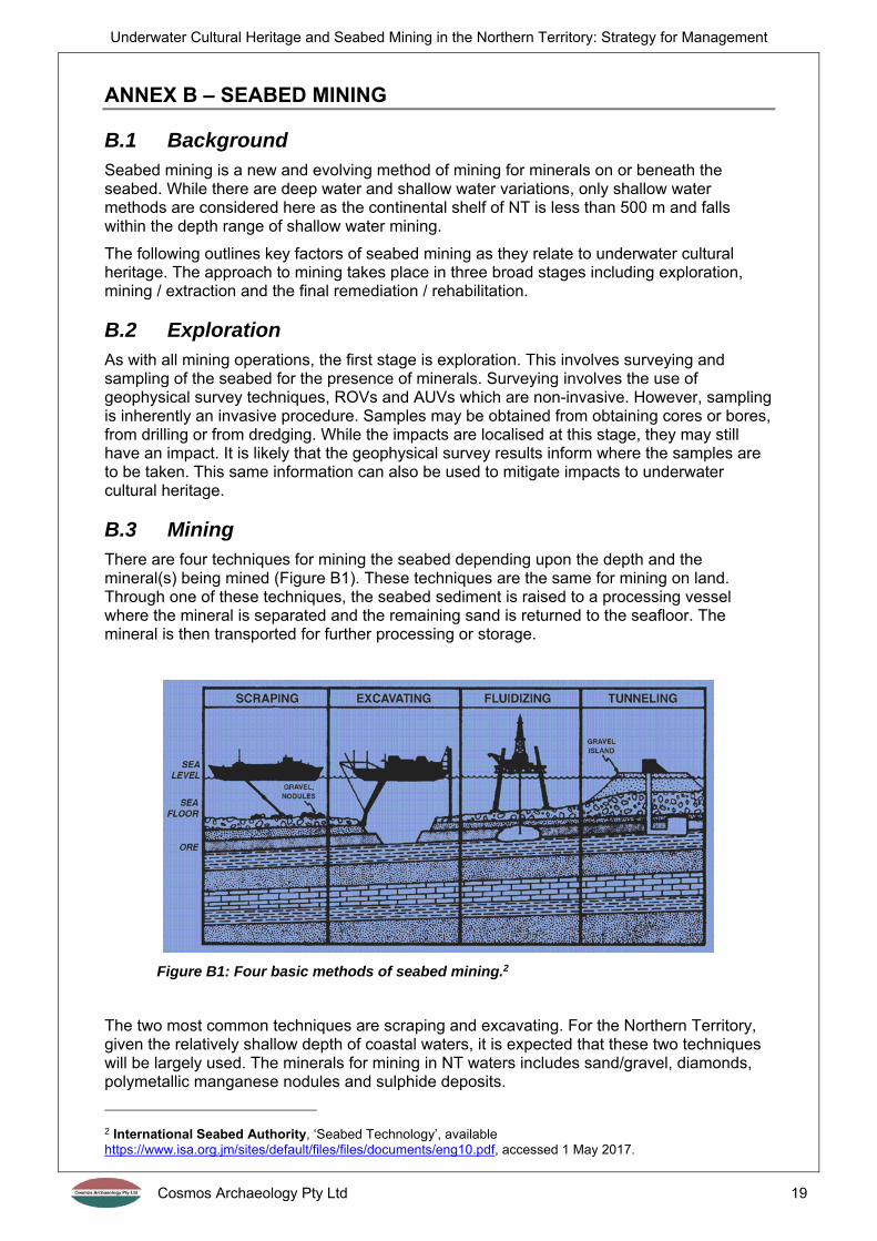
B.3 Mining There are four techniques for mining the seabed depending upon the depth and the mineral(s) being mined (Figure B1). These techniques are the same for mining on land. Through one of these techniques, the seabed sediment is raised to a processing vessel where the mineral is separated and the remaining sand is returned to the seafloor. The mineral is then transported for further processing or storage.
Figure B1: Four basic methods of seabed mining.2
The two most common techniques are scraping and excavating. For the Northern Territory, given the relatively shallow depth of coastal waters, it is expected that these two techniques will be largely used. The minerals for mining in NT waters includes sand/gravel, diamonds, polymetallic manganese nodules and sulphide deposits.
2 International Seabed Authority, ‘Seabed Technology’, available https://www.isa.org.jm/sites/default/files/files/documents/eng10.pdf, accessed 1 May 2017.
Underwater Cultural Heritage and Seabed Mining in the Northern Territory: Strategy for Management
Cosmos Archaeology Pty Ltd 20
Scraping is usually undertaken by the continuous-line bucket system (CLB) which operates like a conveyor-belt, running from the seabed to a ship or platform on the surface. The sediment is processed and the desired minerals extracted, then the tailings are returned to the seabed.3
Excavating involves a hydraulic suction system which involves the lowering of a pipe to the seafloor which transfers sediments and nodules up to the processing vessel. Another pipe returns the tailings to the area of the mining site on the seafloor.4
B.4 Rehabilitation Restoration of offshore marine habitats is a relatively new concept in response to the development of seabed mining. While both techniques discussed above to return tailings to the seabed to the area of the mining site, it is likely that the mined area will still present as a depression or trough. Rehabilitation for seabed mine sites in sandy environments can simply involve re-building the seabed by placing sediment within the mined area. The sediment may consist of dredged material from another area. Another technique is levelling the surrounding seabed to fill the depression. Rehabilitation in gravel environments is similar with the deposition of gravel, or gravel seeding.
3 New Zealand Government, 2016, ‘Seabed Mining’, available https://www.nzpam.govt.nz/assets/Uploads/our-industry/factsheets/seabed-mining.pdf, accessed 1 May 2017. 4 Op. Cit. New Zealand Government, 2016
Underwater Cultural Heritage and Seabed Mining in the Northern Territory: Strategy for Management
Cosmos Archaeology Pty Ltd 21
ANNEX C – CASE STUDIES
C.1 INPEX Ichthys Gas Project, Darwin Harbour, NT INPEX Operations Australia Pty Ltd, on behalf of Ichthys Joint Ventures and Ichthys LNG Pty Ltd were proposing to develop the Ichthys Gas Field in the Browse Basin. As part of the preliminary assessments for the project, an Environmental Impact Statement was required under the Environmental Assessment Act (NT).
As part of the Environmental Impact Statement, the then NT Department of Natural Resources, Environment the Arts and Sports (NRETAS) requested that an appropriately qualified maritime archaeologist assess the suitability and limitations of survey methods and data analysis used by INPEX for the detection of shipwrecks.
In response to this, INPEX engaged maritime archaeologists to assess the survey methods, as above, but also to review the data collected to determine any potential cultural anomalies and review historic sources to assess the likelihood of any unknown wrecks present within the harbour. The review of data identified over 70 vessels known to have been lost in Darwin Harbour, with only 10 with known precise locations. As well as shipwrecks, 25 planes are thought to have been lost along with the potential of cables, nets and munitions associated with WWII. In addition, it was recommended that dive inspections be carried of anomalies identified from the remote sensing data under instructions of a maritime archaeologist.5
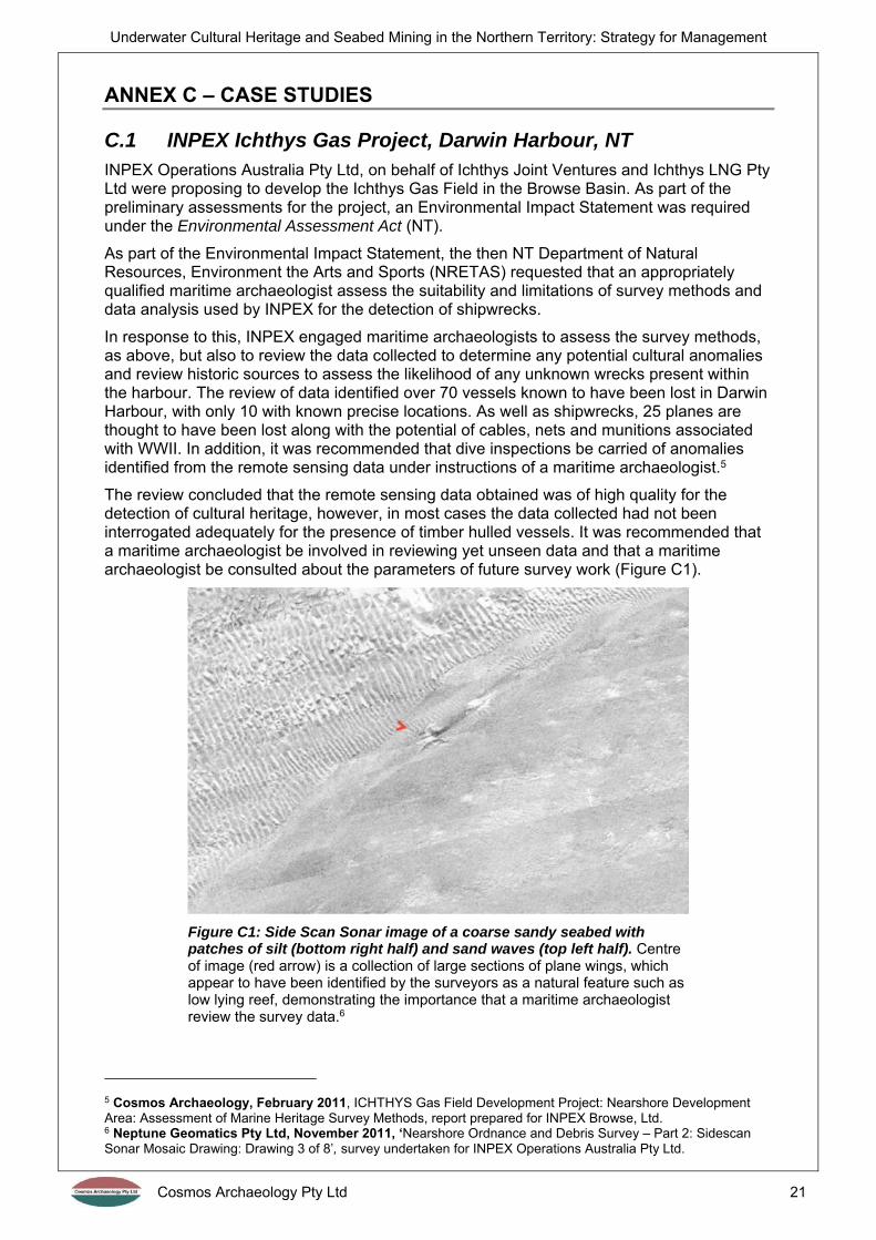
The review concluded that the remote sensing data obtained was of high quality for the detection of cultural heritage, however, in most cases the data collected had not been interrogated adequately for the presence of timber hulled vessels. It was recommended that a maritime archaeologist be involved in reviewing yet unseen data and that a maritime archaeologist be consulted about the parameters of future survey work (Figure C1).
Figure C1: Side Scan Sonar image of a coarse sandy seabed with patches of silt (bottom right half) and sand waves (top left half). Centre of image (red arrow) is a collection of large sections of plane wings, which appear to have been identified by the surveyors as a natural feature such as low lying reef, demonstrating the importance that a maritime archaeologist review the survey data.6
5 Cosmos Archaeology, February 2011, ICHTHYS Gas Field Development Project: Nearshore Development Area: Assessment of Marine Heritage Survey Methods, report prepared for INPEX Browse, Ltd. 6 Neptune Geomatics Pty Ltd, November 2011, ‘Nearshore Ordnance and Debris Survey – Part 2: Sidescan Sonar Mosaic Drawing: Drawing 3 of 8’, survey undertaken for INPEX Operations Australia Pty Ltd.
Underwater Cultural Heritage and Seabed Mining in the Northern Territory: Strategy for Management
Cosmos Archaeology Pty Ltd 22
An occupational scientific dive operator was engaged to undertake the diving inspection of anomalies. They engaged a maritime archaeological company to provide the required expertise for managing the underwater cultural heritage encountered. This led to seventeen months of field work commencing in April 2012, involving a team of over 50 occupational scientific divers and 17 archaeologists who inspected approximately 1077 anomalies, 490 of which yielded cultural objects amounting to a total of 6,897 artefacts. The most significant finds were PBY Catalina and Supermarine Spitfire components. Most of the material had been dumped, presumably at the end of WWII. All items were raised from the seabed for recording and selected items of significance were relocated while the rest were discarded.7
Concurrent with this, as a requirement of the EIS, INPEX were committed to monitor the impacts of sedimentation on six WWII era Catalina flying-boats located in close proximity to the dredge footprint and shipping channel. This included an initial baseline inspection prior to dredging as well as periodical inspections during dredging. Although the dredge footprint had taken into consideration the location of the wrecks and intended to avoid any direct impacts from dredging, the EIS identified the potential for sites to be indirectly impacted. Inspections and monitoring formed an effective measure to mitigate these potential impacts.
The approach to managing underwater cultural heritage in this project had mixed results. First, the EIS only assessed previously located maritime heritage but did not properly assess the potential, through field investigation, of unlocated maritime heritage within the project footprint, which was a significant oversight considering the large amount of unlocated material identified and raised. Also, the Heritage Branch of NRETAS noted that a maritime archaeologist had not been employed during the remote sensing surveys which limited the effectiveness in utilising the remote sensing data to identify potential cultural heritage sites. This resulted in a maritime archaeologist being engaged in all proceeding works to provide input into the remote sensing surveys so the heritage objectives were met with efficiency. The archaeologist’s involvement in different parts of the project also benefited the monitoring process. Familiarisation with the study area enabled the quick identification and significance assessments of heritage material recovered during dredging, considerably reducing potential delays.
C.2 East Point Sewage Outfall, Darwin Harbour, NT The Power and Water Corporation (PWC) were planning an extension of the East Point outfall for sewage in Darwin, Northern Territory. To satisfy requirements of the Northern Territory Department of Lands, Planning and the Environment – Heritage Branch, PWC contracted a maritime archaeology company to undertake a Heritage Impact Assessment (HIA) and Unexploded Ordnance (UXO) survey. The objective of this study was to assess the potential for the presence of submerged cultural heritage within the study area through a desktop study and field investigations so as to provide advice on heritage significance, legislative compliance and mitigation measures.8
The study was divided into two stages, with the findings of the first stage used to refine the scope and methodology of the second stage. All reporting was prepared for PWC and submitted to the Heritage Branch.
Stage One Heritage and UXO Desktop Study
Stage Two Remote Sensing Survey and Inspection
7 Cosmos Archaeology, February 2014, INPEX Ichthys LNG Project: Nearshore Development Dredging, East Arm, Darwin Harbour, Northern Territory: Relocation of Heritage Objects and Removal of Debris, report for Tek Ventures Pty Ltd. 8 Cosmos Archaeology, 2015, East Point Outfall Heritage Impact Assessment and Unexploded Ordnance Summary Report, report for Power and Water Corporation.

Underwater Cultural Heritage and Seabed Mining in the Northern Territory: Strategy for Management
Cosmos Archaeology Pty Ltd 23
The desktop study included:9
A description of the site environment and the effectiveness of surveying the area using various techniques. Side Scan Sonar and gradiometric surveying were advised for the detection of cultural anomalies, however, the intertidal rock platforms closer to shore were considered best examined by pedestrian survey at low tide;
An historical background of East Point, focussing on activities and uses that may have resulted in cultural material;
A prediction of the types of cultural material that may be found as well as their condition and how they may be identified in remote sensing surveys; and,
A UXO desktop assessment prepared by a company that specialises in the UXO detection.
The remote sensing survey included:
Side Scan Sonar and gradiometer surveys by EGS (Figure C2); and, Production of a short report by Cosmos Archaeology summarising the findings of the
survey and presenting a list of targets (134) which were considered to be of potential heritage significance or UXO, as well as a proposed prioritised approach to examine them through diving.10
Figure C2: Quasi-analytical signal map of all magnetic contacts labelled by their ID numbers (punctual targets, in red; linear targets in black). Boundaries of magnetically noisy areas are also shown (in blue). Proposed outfall pipe route in magenta.11
The inspection and final reporting included:12
Dive investigations by an occupational scientific dive operator, in constant contact with a maritime archaeologist;
A pedestrian survey of the intertidal areas;
9 Cosmos Archaeology, 2014a, East Point Outfall Heritage Impact Assessment and Unexploded Ordnance Survey Desktop Study, report for Power and Water Corporation. 10 Cosmos Archaeology, 2014b, East Point Outfall Heritage Impact Assessment and Unexploded Ordnance Remote Sensing Survey Analysis of Data and Briefing Notes, short letter report for Power and Water Corporation. 11 EGS Survey Pty Ltd, August 2014, Side Scan Sonar & UXO Survey, East Point Outfall, Darwin: Survey Report, report for Cosmos Archaeology Pty Ltd: Figure 3. 12 Cosmos Archaeology, 2014c, East Point Outfall Heritage Impact Assessment and Unexploded Ordnance Survey Field Investigation Results and Analysis, report for Power and Water Corporation.
Underwater Cultural Heritage and Seabed Mining in the Northern Territory: Strategy for Management
Cosmos Archaeology Pty Ltd 24
Findings from the 70 targets that were inspected, of which 11 contained cultural objects;
Assessments of heritage significance for the identified objects; Statutory and compliance issues; and, Recommendations to minimise impact, including a heritage monitoring plan.
This project was separated into two clear stages that involved all three investigation methods – desktop, remote sensing survey and field inspections. In this case study, the maritime archaeologist was directly in control of the remote sensing undertaken in order to return the best results for the heritage objectives. The same applied to the diving inspections, despite being carried out by an occupational scientific dive operator. The archaeologist was then able to produce informative reports on the presence of underwater cultural heritage. Extensive field investigations also meant that there was a low chance of unknown finds being made during the construction phase and causing delays to the project.
C.3 Channel Deepening Project, Port Phillip Bay, Melbourne The Port of Melbourne Corporation (PoMC) were proposing to modify the shipping channels of Port Phillip Bay leading to the Port of Melbourne. This required works including modifications to existing channels and upgrading of infrastructure. The works had the potential to impact on non-Aboriginal heritage sites. As part of the preliminary assessments for this project, PoMC engaged specialists to prepare a Supplementary Environment Effects Statement (SEES). As part of this, PoMC also engaged heritage consultants to undertake the Non-Aboriginal Heritage component of the SEES. Consultants specialising in maritime heritage were subcontracted to the main heritage outfit to provide research and advice on marine heritage elements of the project.13
Preparation of the Non-Aboriginal Heritage component of the SEES included the following:
A desktop assessment, which identified 304 marine sites and 176 coastal sites; An impact assessment, which identified only a small number potentially at risk of
impact from the works; Coastal inspections and some diving inspections to clarify mitigation requirements; Proposed specific and general mitigation measures for key predicted impacts.14
A range of mitigation measures were used for specific identified sites depending upon the type and extent of impact as well as the site itself. The measures included: recording by measured plan, photographic recording, test excavations, removal of items from the seabed, site stabilisation, an inspection prior to and immediately after dredging, regular inspections during construction and post-construction monitoring.
The SEES also recommended that a review of geophysical survey data be made by an archaeologist prior to dredging to identify anomalies not identified in the study. It also recommended to establish an archaeological monitoring protocol for the dredging phase in the event that marine heritage sites were discovered.15
With the implementation of these recommendations, it was assessed in the SEES that the impacts posed by the project were acceptable and could be managed appropriately. These recommendations were incorporated into the CDP Environmental Management Plan and formed the basis for Heritage Victoria to grant Consents to the development in accordance with the Victorian Heritage Act 1995.16
The heritage specialists were then re-engaged by PoMC to undertake the mitigation measures before, during and after the project works. As an example, for the marine heritage
13 TerraCulture Pty Ltd, 2007, Channel Deepening Project Supplementary Environment Effects Statement – Non-Aboriginal Heritage, report prepared for Port of Melbourne Corporation. 14 Op. Cit. TerraCulture Pty Ltd, 2007 15 Op. Cit. TerraCulture Pty Ltd, 2007 16 Cosmos Archaeology, 2009, Channel Deepening Project: Lower South Wharf No.32 (H7822-0598) Archaeological Monitoring August 2008 – January 2009, report for Port of Melbourne Corporation.

Underwater Cultural Heritage and Seabed Mining in the Northern Territory: Strategy for Management
Cosmos Archaeology Pty Ltd 25
aspects alone, a company that specialised in maritime archaeology was engaged to undertake the following projects:
Cultural heritage impact assessment of the heritage listed South Channel UNID Dromana (S 894) wreck
Archaeological monitoring of Lower South Wharf No.32 Archival recording, archaeological recording and monitoring of Stony Creek Ballast
Loading Wharf Seventeen separate reviews of multi-beam sonar data for the project prior to
dredging (Figure C3 and Figure C4) Excavation and relocation of the heritage listed Former Hovell Pile Light (1924-1938) Archaeological excavation of dumped rock and artefacts Recovery, recording and relocation of the Hovell Pile wheels and axle Initial site inspection of heritage listed Edwards (S209) shipwreck and inspection of
heritage listed Isabella Watson (S346) shipwreck Eight separate reviews of bathymetric survey data after dredging had been
completed; Seven seasonal heritage inspections of the South Channel Pile Light after dredging; Eight seasonal heritage inspections of the unidentified wreck thought to be Nairana
after dredging; Archaeological monitoring of the Francis St wharves, timber sheet piling.
Figure C3: Multi beam image showing chain running along seabed. Surveyors did not record the very large anchor located at the end of the chain, in the bottom left of the image. (Source: Melbourne Port Corporation)
Figure C4: Diver inspecting anchor located at the end of the chain. (Source: Cosmos Archaeology)
This project shows the effective management of underwater cultural heritage from the initial assessment phase through to carrying out the mitigation measures before dredging, during the dredging process and after completion of works.
C.4 Hong Kong SAR The Hong Kong Special Administrative Region (SAR) practises proactive management of underwater cultural heritage in relation to seabed development. The Antiquities and Monuments Ordinance (Chapter 53 of the Laws of Hong Kong) contains provisions for the protection of cultural heritage is linked to the Environmental Impact Assessment (EIA) Ordinance (Chapter 499) planning instrument. The latter Ordinance requires the impacts of a

Underwater Cultural Heritage and Seabed Mining in the Northern Territory: Strategy for Management
Cosmos Archaeology Pty Ltd 26
designated project, such as dredging operations and reclamations, on sites of cultural heritage importance to be mitigated as part of the project approval process.17
The Ordinance’s EIA Technical Memorandum gives guidelines for assessing impact and significance and identifies a general presumption in favour of the protection and conservation of all sites of cultural heritage. It requires impacts on such sites are to be kept to a minimum. EIA Study Briefs issued by the Environmental Protection Department almost always include the requirement to engage “a suitably qualified marine archaeologist … [to] identify whether there is any possible existence of sites or objects of cultural heritage, for example shipwrecks, within any seabed areas that would be affected by the marine works of the Project”. The archaeologist is also required to adhere to the Guidelines for Marine Archaeological Investigation (MAI) issued by the Antiquities and Monuments Office which includes four tasks to be followed for a successful MAI:
Task 1 Baseline Review – desktop study that examines existing archaeological, historical, geotechnical and hydrographical data to predict the extent, variety, condition and significance of underwater cultural heritage within the development footprint.
Task 2 Geophysical Survey – using remote sensing technologies calibrated for best heritage results
Task 3 Establishing Archaeological Potential – combines the results of Task 1 and 2 to identify areas or anomalies of archaeological potential and formulate a strategy for Task 4 (if there are anomalies)
Task 4 Remove Operated Vehicle / Visual Diver Survey / Watching Brief – investigate anomalies. If archaeological material is found, contact relevant authorities and seek guidance on its significance and the preparation of appropriate mitigation measures.
The Guidelines for MAI are founded on solid archaeological principles which conform to the UNESCO Convention for the Protection of Underwater Cultural Heritage. It provides developers and project managers with a clear understanding of the steps involved in the management of underwater cultural heritage at the project development and approval stage.18
This approach to managing underwater cultural heritage has proven effective with simple guidelines that involve the qualified maritime archaeologist at an early stage in order to assess and mitigate impacts.
C.4.1 Hong Kong – Zhuhai – Macao Bridge, Hong Kong SAR
A case study showing the effective implementation of the MAI process is for the Hong Long – Zhuhai – Macao Bridge: Hong Kong Section and North Lantau Highway Connection project. The tasks of the MAI were individually contracted to a maritime archaeologist outfit.
The Task 1 report reviewed the potential for archaeological resources, their likely character, extent, quality and value that may be impacted by the proposed bridge.19 It found that there was considerable maritime related activity occurring on the north-west coast of Lantau in the form of fishing, local and international trade, piracy and naval engagements. The study identified the potential for shipwrecks to occur across the whole of the study area as well as maritime infrastructure sites and submerged prehistoric sites. It recommended that Tasks 2 and 3 of the MAI be implemented.
17 Coroneos, Cosmos, 2006, The Four Commandments: The Response of Hong Kong SAR to the Impact of Seabed Development on Underwater Cultural Heritage, Heritage at Risk Special Edition, Grenier, R., Nutley, D. and Cochran, I. (eds.), ICOMOS:46-49 18 Op. Cit. Coroneos, Cosmos, 2006 19 Coroneos, Cosmos, 2004a, Hong Kong – Zhuhau – Macao Bridge: Hong Kong Section and North Lantau Highway Connection: Marine Archaeological Investigation Task 1 – Baseline Review, report for Archaeo-Environments Limited.
Underwater Cultural Heritage and Seabed Mining in the Northern Territory: Strategy for Management
Cosmos Archaeology Pty Ltd 27
Task 2 was undertaken by a specialised surveying company and the marine geophysical data was given to a maritime archaeologist for assessment as part of Task 3. The Task 3 report identified anomalies of archaeological potential in the vicinity of the proposed bridge.20 It recommended that diving be undertaken and supervised by a qualified maritime archaeologist of targets of archaeological potential. It also recommended that an immediate impact assessment be undertaken if sites of cultural heritage are identified during the dive.
Divers inspected 26 seabed anomalies of archaeological potential as part of Task 4. No archaeological remains of cultural significance were identified. The Task 4 report recommended that construction contractors be briefed by a maritime archaeologist on procedures to be implemented upon the discovery of artefacts, and that an immediate impact assessment be undertaken if any objects or sites were discovered during the construction.21
C.5 London Gateway Project, River Thames, Essex, England The London Gateway project comprised redevelopment of port facilities at the former Shell Haven oil refinery in Essex. It involved dredging over a considerable area of the channel. At the start of this project, there was an absence of an established practice for assessing maritime heritage as it was the first commercial project since the passing of the National Heritage Act in 2002 which now extended the limit of English Heritage’s remit to territorial waters.22
There was a need to implement a program of assessment and mitigation that could be integrated into the construction program. As this was breaking new ground in the United Kingdom, a staged approach was determined so that each stage could be assessed for effectiveness before beginning the next stage. The stages were as follows:23
Stage 1 Desk-based assessment – indicated a substantial number of potential sites including shipwrecks, aircraft wrecks and wartime defensive structures.
This stage found two important wreck sites. In order to avoid impacts, the channel was re-designed at this early stage to allow the wrecks to remain in situ and archaeological exclusion zones established around both.
Stage 2 Survey – originally involving low resolution SSS data from 2001 that was of limited use. In 2002, a high resolution SSS survey was tailored to suit archaeological objectives and could be effectively used. By 2005, technology had improved to allow for an even higher resolution. This data provided crucial information for determining the character and extend of known sites and anomalies.
Stage 3 Assessment of importance – all sites were prioritised by a rating of confidence in their anthropogenic origin and potential archaeological importance. 600 site groups resulted, which was beyond the resources for diving inspections. Instead, 29 sites were prioritised based on sites that were most likely cultural.
20 Coroneos, Cosmos, 2004b, Hong Kong – Zhuhau – Macao Bridge: Hong Kong Section and North Lantau Highway Connection: Marine Archaeological Investigation Task 3 – Assessment of Archaeological Potential, report for Archaeo-Environments Limited. 21 Coroneos, Cosmos, 2004c, Hong Kong – Zhuhau – Macao Bridge: Hong Kong Section and North Lantau Highway Connection: Marine Archaeological Investigation – Visual Diver Survey, report for Archaeo-Environments Limited 22 PIANC: The World Association for Waterborne Transport Infrastructure, 2014, PIANC Guidance Document N. 124: Environmental Navigation Commission – Dredging and Port Construction: Interactions with Features of Archaeological or Heritage Interest: Appendix II: London Gateway Port Development: Sampling and Mitigation in Practice, p.53-58 23 Op. Cit. PIANC: The World Association for Waterborne Transport Infrastructure, 2014: Appendix II
Underwater Cultural Heritage and Seabed Mining in the Northern Territory: Strategy for Management
Cosmos Archaeology Pty Ltd 28
A Clearance Mitigation Statement (CMS) was developed to focus further investigation and mitigation of sites which were inspected. These were updated with any new results from survey, research or diving.
Stage 4 Pre-dredge clearance investigation – undertaken in two stages.
Stage I involved initial non-intrusive evaluation involving observation and recording only. 18 sites were chosen.
Stage II was intrusive and designed to recover finds and record features in situ to determine the characteristics of the site. 7 sites were chosen.
Stage 5 Dredging and the Marine Archaeological Protocol – the protocol included an on-board archaeological watching brief where anomalies were high. This required the dredging contractor to report any finds recovered, which were then compiled into reports by the archaeological team. 600 finds were made including a large number of timbers indicative of wreck sites.
This staged approach worked effectively due to the close co-operation between the developer (DPWorld), heritage department (English Heritage), port authority (Port of London Authority) and archaeologists. Techniques developed for this project have been widely adopted as part of project mitigation programs in the United Kingdom. A few key points are worth raising and highlighting include:24
Early establishment of exclusion zones and channel re-design to preserve significant sites in situ;
Undertaking geophysical surveys to suit archaeological analysis; Diving efforts focused on likely sites, however, this approach has been reconsidered
by the archaeological team who consider that sampling should have been undertaken on the sites categorised as lower likelihood;
Some sites were managed without further archaeological intervention by avoidance or resettlement. Two shipwrecks were shifted into deeper water, however, it was later considered that archaeological recording should have taken place prior to relocation. Also, resettlement of vessels should take into account the complications of potential human remains.
Diving for this project took place partially by an archaeological team and partially using a limited number of archaeologists integrated into an occupational scientific dive team. Both structures operated well, and it is noted that the local knowledge of occupational scientific divers helping in the planning and briefing stages.
The Marine Archaeological Protocol was conditional for dredging and proved a key tool in order to record a large amount of material.
C.6 Southampton Approach Channel Dredge, Hampshire, England
The Southampton Approach Channel Dredge scheme involved deepening and widening the navigational channel to improve access for vessels. An estimated 11.6 million cubic metres was predicted to be dredged at the start of the project using a Trailing Suction Hopper Dredger (TSHD) and mechanical dredger for dense areas.25
As part of the Environmental Statement (ES) for the scheme, a desk-based assessment was commissioned to include review of relevant records, geotechnical data and an archaeologically designed geophysical survey.
24 Op. Cit. PIANC: The World Association for Waterborne Transport Infrastructure, 2014: Appendix II 25 PIANC: The World Association for Waterborne Transport Infrastructure, 2014, PIANC Guidance Document N. 124: Environmental Navigation Commission – Dredging and Port Construction: Interactions with Features of Archaeological or Heritage Interest: Appendix III: Southampton Approach Channel Dredge: Geophysical, Archaeological and Geoarchaeological Investigations, p.59-64

Underwater Cultural Heritage and Seabed Mining in the Northern Territory: Strategy for Management
Cosmos Archaeology Pty Ltd 29
The desk-based assessment was undertaken as follows:26
Stage 1 Geophysical survey – echo sounder, side scan sonar, sub-bottom profiler and magnetometer surveys conducted by the archaeology company and subsequently processed and interpreted for archaeological purposes.
Identified 227 anomalies, including 125 of archaeological potential. The geophysical data was also interpreted with regard to understanding the potential palaeolandscapes in the areas.
Stage 2 Geoarchaeological review – 54 vibrocore and 10 boreholes were drilled for geotechnical engineering purposes and archaeologically assessed. The type of sediment and elevation were compared to past sea levels and patterns of human occupation of NW Europe.
Assessed to have the potential to contain prehistoric, terrestrial archaeological material dating to periods prior to when the study area would have been submerged by the last sea level rise c. 8000 years ago.
Stage 3 Desk-based assessment – included a review of records and findings from the geophysical and archaeological data. Known and potential sites compiled in a gazetteer.
Assessment identified the potential for wrecks covering from c. 6000 years ago to the present day. There was also some potential for the presence of submerged prehistoric archaeology. Thirty-seven anomalies were identified, with 14 assumed to be anthropogenic and relatively recent.
The desktop assessment indicated that the scheme had the potential to impact both known and potential archaeological remains. It was recommended that an archaeological-based Written Scheme of Investigation be implemented to mitigate the archaeological impacts, including archaeological diving, bulk sampling, geoarchaeological and palaeoenvironmental work and a protocol for archaeological discoveries.27
Stage 4 Ongoing mitigation and investigations
Some bulk samples were taken from specific sedimentary units with archaeological potential in order to more fully assess archaeological contents. The samples were sieved and residues scanned for material.
A diving plan included investigating 12 geophysical anomalies, undertaken by archaeologists using surface supplied apparatus and GPS diver tracking to direct the diver to the anomaly.
A Finds Reporting Protocol was used during dredging which made provision for prompt reporting of archaeological material, establishing temporary exclusion zones if required, prompt archaeological advice and, if required, archaeological inspection.
This project was undertaken with the same elements as discussed elsewhere, however, they proceeded in a different order. In this case, the archaeological company, had the resources to undertake geophysical surveys to be incorporated directly into their desk-based report. It is likely that Stages 1 to 3 occurred concurrently and that the geophysical surveys were guided by initial findings of the desk-based review of records. Of key importance is that the surveys were inherently archaeologically designed for the best application to the archaeological assessment. Also, geoarchaeological and palaeoenvironmental studies played a core part of the research and investigation.
26 Op. Cit. PIANC: The World Association for Waterborne Transport Infrastructure, 2014: Appendix III 27 Op. Cit. PIANC: The World Association for Waterborne Transport Infrastructure, 2014: Appendix III

Underwater Cultural Heritage and Seabed Mining in the Northern Territory: Strategy for Management
Cosmos Archaeology Pty Ltd 30
ANNEX D – GEOPHYSICAL SURVEY TECHNIQUES
Table D1: Geophysical survey techniques and their application for identifying underwater cultural anomalies.
Geophysical Survey
Technique Advantages Disadvantages
Applicable Site Types
Multi beam sonar
Can depict seabed topography and large cultural shapes with high relief. Useful for detailed site survey.
Less reliable for distinguishing textures and low relief objects. Requires operators to be fully briefed on what they are looking for.
Largely intact wrecks
Side Scan Sonar (SSS)
Easier for distinguishing low relief cultural features.
Rocky seabeds can produce too much ‘noise’ in the data for identifying cultural anomalies unless very large.
Cultural debris scatters and low relief wreckage as well as upstanding structures.
Gradiometer Can pick up ferrous objects that are buried or on rocky seabeds.
Not effective in areas where sediments and bedrock have high ferrous content.
Cables, unexploded ordnance and small timber wrecks that have ferrous content such as engines, chains and anchors.
Seismic survey
Useful for identifying geological strata.
Buried anomalies are difficult to interpret in the data. Surveying can ‘miss’ buried timber objects close to the seabed surface.
Buried cultural objects and potential locations for submerged terrestrial sites.
Coring Useful for identifying the nature of the sediment and rock strata.
Very narrow area investigated per core.
Potential locations for submerged terrestrial sites.

Underwater Cultural Heritage and Seabed Mining in the Northern Territory: Strategy for Management
Cosmos Archaeology Pty Ltd 31
ANNEX E – LEGISLATION AND REGULATIONS
Underwater cultural heritage values in the Northern Territory (NT) are protected and managed under a hierarchy of legislation. The following section provides a brief summary of the relevant statutory regulations.
E.1 Commonwealth legislation
E.1.1 Environment Protection and Biodiversity Conservation Act 1999
The Environment Protection and Biodiversity Conservation Act 1999 (the EPBC Act) is the Australian Government's central piece of environmental legislation. It provides a legal framework to protect and manage matters of national environmental significance, including heritage places.
The National Heritage List (NHL) is a list of natural, historic and Indigenous places that are of outstanding heritage significance to Australians and are considered to have National Heritage value. Places on the NHL are recognised and protected under the EPBC Act. Prior to being listed on the NHL, a place is assessed against set criteria by the Australian Heritage Council, which then makes a recommendation to the Minister for the Department of Sustainability, Environment, Water, Population and Communities.
Any proposed actions to a National Heritage place which have, will have, or are likely to have, a significant impact on its National Heritage values, must be referred to the Minister. Actions which constitute a significant impact to a National Heritage place are those that will cause:
one or more of the National Heritage values to be lost; one or more of the National Heritage values to be degraded or damaged; or, one or more of the national Heritage values to be notably altered, modified, obscured
or diminished.
The Minister will make a decision as to whether or not the proposed actions constitute a significant impact and require approval under the EPBC Act. If approval is required, an environmental assessment of the proposed development must be carried out.
The Commonwealth Heritage List (CHL) comprises natural, Indigenous and historic heritage places which are wither entirely within a Commonwealth area or outside the Australian jurisdiction and owned or leased by the Commonwealth or a Commonwealth Authority; and which the Minister is satisfied have one or more Commonwealth Heritage values.
Amendments to the EPBC Act in February 2007 established a new process for listing Commonwealth heritage places and introduced an assessment cycle. Anyone can nominate a place for the CHL and the nominated places are assessed by the Australian Heritage Council against a set of criteria. A recommendation is made to the Minister for the Environment who makes the final decision.
Australian Government agencies are required to develop heritage strategies, a heritage register and management plans for places on the CHL in accordance with the Commonwealth Heritage management principles.
E.1.2 Historic Shipwrecks Act 1976
The Historic Shipwrecks Act 1976 (HSA 1976) protects historic wrecks and relics in Commonwealth waters, extending from below the low water mark. For the purposes of this study, any shipwrecks within the Northern Territory coastal waters would be under the jurisdiction of this Act.
Under Section 4A(1) of the Act, all shipwrecks are declared historic and afforded automatic protection if they are:

Underwater Cultural Heritage and Seabed Mining in the Northern Territory: Strategy for Management
Cosmos Archaeology Pty Ltd 32
a) Situated in Australian waters, or waters above the continental shelf of Australia, adjacent to the coast of the state; and
b) At least 75 years old.
At the time of writing, vessels wrecked before 1942 are protected under the Act. Other shipwrecks can be declared historic and granted this protection on an individual basis according to their particular merits such as the I-124 Japanese submarine.
Under Section 13(1a) of the Act, it is an offence if a person:
i) Destroys or causes damage to a historic shipwreck or historic relic; or
ii) Causes interference with a historic shipwreck or historic relic; or
iii) Causes the disposal of a historic shipwreck or relic; or
iv) Causes a historic shipwreck or historic relic to be removed from Australia (including State waters), from Australian waters or from waters above the continental shelf of Australia.
If a person is found guilty of this offence, the penalty is up to $10,000 or imprisonment for up to five years, or both. If the offender is a corporate body, the penalty is up to $50,000.
Under Section 17(1) of the Act, persons who discover the remains of a ship or part of a ship, or an article associated with a ship, are legally obligated to notify the appropriate authorities of the discovery as soon as practicable. The penalty for not doing so is $5,000 for a person or $25,000 for a body corporate.
E.2 Northern Territory legislation
E.2.1 Heritage Act
The NT Heritage Act 2011 (replacing the Heritage Conservation Act 1991) came into force on 1 October 2012. Section 153 of Chapter 8 of the new Act automatically protects all of the places and objects previously declared under the superseded Heritage Conservation Act. All places or objects previously protected by “interim conservation orders” under the superseded Act are now afforded protection under a “provisional declaration” under Section 156 of Chapter 8 of the new Act.
The objective of the Act is to provide for the conservation of the Northern Territory's cultural and natural heritage. This is achieved by:
Declaring places and objects of heritage significance to be heritage places and objects;
Declaring classes of places and objects of heritage significance to be protected classes of heritage places and objects;
Establishing the Heritage Council; Providing for heritage agreements to encourage the conservation, use and
management of heritage places and objects; Regulating work on heritage places and objects; and, Establishing enforcement and offence provisions.
The NT Heritage Act 2011 protects nominated and declared heritage places and gives automatic protection to all Aboriginal and Macassan archaeological sites. The Northern Territory Heritage Register maintained under the Act contains details about all declared heritage places and objects and protected classes of heritage places and objects. It also includes details of interim conservation orders (now called “provisional declarations”), conservation management plans and heritage agreements.
Under Part 5.5 of the Act, it is an offence if a person engages in conduct that results in damage to a heritage place or object unless the conduct is in accordance with either a

Underwater Cultural Heritage and Seabed Mining in the Northern Territory: Strategy for Management
Cosmos Archaeology Pty Ltd 33
heritage agreement, a work approval, a repair order, or the work authorised under the declaration of heritage place or object.
E.2.2 Environmental Assessment Act
The Environmental Assessment Act and its subordinate Environmental Assessment Administrative Procedures establish the framework for the assessment of potential or anticipated environmental impacts of development. The object of the Act is to ensure that matters affecting the environment to a significant extent are fully examined and taken into account in decisions by the Northern Territory Government.
The scale and complexity of a proposed development, and the significance of potential impacts will determine if assessment is at the level of Public Environmental Report or Environmental Impact Statement. In addition to assessing the potential impacts, the assessment process also evaluates the effectiveness of the proposed safeguards to mitigate these impacts and recommends actions to ensure the construction and operational phases of a project can be managed in an environmentally sound manner.
E.3 International legislation
E.3.1 United States Sunken Military Craft Act
The Sunken Military Craft Act, which is Title XIV of the National Defence Authorization Act for the Fiscal Year 2005, is administered by the United States (US) Naval History and Heritage Command.
The Act preserves the sovereign status of sunken US military vessels and aircraft by codifying both their protected sovereign status and permanent US ownership, regardless of age. It protects sunken military vessels and aircraft from unauthorised disturbance, including the graves of lost military personnel, sensitive archaeological artefacts and historical information.
Under this Act, it is an offence to engage or attempt to engage in any activity directed at a sunken military craft that disturbs, removes, or injures any sunken military craft except as authorised by a permit under the Act, regulations issued under the Act or as otherwise authorised by law.
E.4 Guidelines
E.4.1 UNESCO Convention on the Protection of the Underwater Cultural Heritage (2001)
The UNESCO Convention on the Protection of the Underwater Cultural Heritage was adopted in 2001 with the intention to enable those countries or ‘States’ who have ratified to better protect submerged cultural heritage.
The Convention sets out the basic principles for the protection of underwater cultural heritage, provides a detailed cooperation system and provides widely recognised practical rules for the treatment and research of underwater cultural heritage.
The main principles are as follows:
Obligation to Preserve Underwater Cultural Heritage – States Parties should preserve underwater cultural heritage and take action accordingly. This does not mean that ratifying States would necessarily have to undertake archaeological excavations; they only have to take measures according to their capabilities. The Convention encourages scientific research and public access.
In-Situ Preservation as first option – The in situ preservation of underwater cultural heritage (i.e. in its original location on the seafloor) should be considered as the first option before allowing or engaging in any further activities. The recovery of objects may, however, be

Underwater Cultural Heritage and Seabed Mining in the Northern Territory: Strategy for Management
Cosmos Archaeology Pty Ltd 34
authorized for the purpose of making a significant contribution to the protection or knowledge of underwater cultural heritage.
No Commercial Exploitation – The 2001 Convention stipulates that underwater cultural heritage should not be commercially exploited for trade or speculation, and that it should not be irretrievably dispersed. This regulation is in conformity with the moral principles that already apply to cultural heritage on land. It is not to be understood as preventing archaeological research or tourist access.
Training and Information Sharing – States Parties shall cooperate and exchange information, promote training in underwater archaeology and promote public awareness regarding the value and importance of Underwater Cultural Heritage.
E.4.2 Burra Charter
The Australia ICOMOS Charter for Places of Cultural Significance, The Burra Charter 2013 provides a best practice standard for managing cultural heritage places in Australia. The Burra Charter was first adopted in 1979 but is periodically updated to reflect developing understanding of the theory and practice of cultural heritage management.
The Charter can be applied to all types of places of cultural significance including natural, Indigenous and historic places with cultural values. The Burra Charter advocates a cautious approach to change: do as much as necessary to care for the place and to make it useable, but otherwise change it as little as possible so that its cultural significance is retained. The Charter includes 12 conservation principles which are further developed in the processes and practice sections of the Charter.
E.4.3 Guidelines for the management of Australia’s Shipwrecks
The Guidelines for the Management of Australia’s Shipwrecks was produced as a combined publication by the Australian Institute for Maritime Archaeology Inc. (now the Australasian Institute for Maritime Archaeology) and the Australian Cultural Development Office (now the Australian Government Department of the Environment and Energy) in 1994.
The guidelines comprise principles and practice that Australia’s professional maritime archaeologists have adopted and to serve as useful modules for other groups. The document includes Statement of Principles that should govern the broad approach of anyone planning to deal with historic shipwreck sites and related archaeological collections.
Underwater Cultural Heritage and Seabed Mining in the Northern Territory: Strategy for Management
Cosmos Archaeology Pty Ltd 35
REFERENCES
Cosmos Archaeology, 2009, Channel Deepening Project: Lower South Wharf No.32 (H7822-0598) Archaeological Monitoring August 2008 – January 2009, report for Port of Melbourne Corporation.
Cosmos Archaeology, February 2011, ICHTHYS Gas Field Development Project: Nearshore Development Area: Assessment of Marine Heritage Survey Methods, report prepared for INPEX Browse, Ltd.
Cosmos Archaeology, February 2014, INPEX Ichthys LNG Project: Nearshore Development Dredging, East Arm, Darwin Harbour, Northern Territory: Relocation of Heritage Objects and Removal of Debris, report for Tek Ventures Pty Ltd.
Cosmos Archaeology, 2014a, East Point Outfall Heritage Impact Assessment and Unexploded Ordnance Survey Desktop Study, report for Power and Water Corporation.
Cosmos Archaeology, 2014b, East Point Outfall Heritage Impact Assessment and Unexploded Ordnance Remote Sensing Survey Analysis of Data and Briefing Notes, short letter report for Power and Water Corporation.
Cosmos Archaeology, 2014c, East Point Outfall Heritage Impact Assessment and Unexploded Ordnance Survey Field Investigation Results and Analysis, report for Power and Water Corporation.
Cosmos Archaeology, 2015, East Point Outfall Heritage Impact Assessment and Unexploded Ordnance Summary Report, report for Power and Water Corporation.
Coroneos, Cosmos, 2004a, Hong Kong – Zhuhau – Macao Bridge: Hong Kong Section and North Lantau Highway Connection: Marine Archaeological Investigation Task 1 – Baseline Review, report for Archaeo-Environments Limited.
Coroneos, Cosmos, 2004b, Hong Kong – Zhuhau – Macao Bridge: Hong Kong Section and North Lantau Highway Connection: Marine Archaeological Investigation Task 3 – Assessment of Archaeological Potential, report for Archaeo-Environments Limited.
Coroneos, Cosmos, 2004c, Hong Kong – Zhuhau – Macao Bridge: Hong Kong Section and North Lantau Highway Connection: Marine Archaeological Investigation – Visual Diver Survey, report for Archaeo-Environments Limited
Coroneos, Cosmos, 2006, The Four Commandments: The Response of Hong Kong SAR to the Impact of Seabed Development on Underwater Cultural Heritage, Heritage at Risk Special Edition, Grenier, R., Nutley, D. and Cochran, I. (eds.), ICOMOS:46-49
EGS Survey Pty Ltd, August 2014, Side Scan Sonar & UXO Survey, East Point Outfall, Darwin: Survey Report, report for Cosmos Archaeology Pty Ltd
Geoscience Australia, Australian Government, Maritime Boundary Definitions, available http://www.ga.gov.au/scientific-topics/marine/jurisdiction/maritime-boundary-definitions, accessed 18 May 2017.
International Seabed Authority, ‘Seabed Technology’, available https://www.isa.org.jm/sites/default/files/files/documents/eng10.pdf, accessed 1 May 2017.
Neptune Geomatics Pty Ltd, November 2011, ‘Nearshore Ordnance and Debris Survey – Part 2: Sidescan Sonar Mosaic Drawing: Drawing 3 of 8’, survey undertaken for INPEX Operations Australia Pty Ltd.
New Zealand Government, 2016, ‘Seabed Mining’, available https://www.nzpam.govt.nz/assets/Uploads/our-industry/factsheets/seabed-mining.pdf, accessed 1 May 2017.
PIANC: The World Association for Waterborne Transport Infrastructure, 2014, PIANC Guidance Document N. 124: Environmental Navigation Commission – Dredging and Port Construction: Interactions with Features of Archaeological or Heritage Interest:
TerraCulture Pty Ltd, 2007, Channel Deepening Project Supplementary Environment Effects Statement – Non-Aboriginal Heritage, report prepared for Port of Melbourne Corporation.