unit 11 marine meteorology - university of rijeka · marine meteorology basic terms weather report...
TRANSCRIPT

Unit 11
MARINE METEOROLOGY
Basic terms
weather report
pressure
barometer
anticyclone
heavy winds / rain
haze
mist
depression
fair-weather system
bad-weather system
centre of depression
halo
veering wind
backing wind
thunderstorm
heavy seas
Meteorology is the study of weather patterns with the
object of predicting change in the weather. It is a complex science, based on current weather reports over a large area, and it is of great importance to navigators (recent units are given in hecto-pascals).
To the navigator the atmospheric pressure in the vicinity of his position at sea is the most important guide he has to the likely behaviour of the weather in the immediate future.
Atmospheric pressure is measured by the height of a column of mercury. Another method of measuring atmospheric pressure is with an aneroid barometer. The average atmospheric pressure at sea level in millibars is 1,013 in winter and 1,016 in summer.
There are two main weather systems in the general weather patterns, anticyclones and depressions.
In the northern hemisphere an anticyclone is a system of wind which circulates spirally in a clockwise direction around an area of high pressure, which can at times cover an area of immense size. In the southern hemisphere the anticyclone wind circulates in an anti-clockwise direction, though still around a high pressure area. The stronger winds are found at the outer limits of the anticyclone, those nearer the centre being very light or at times non-existent. This is always a fair-weather system, with the air dry and the wind strength never more than moderate.

Anticyclones (or highs) are normally slow moving and sometimes stationary for quite long periods. The approach of an anticyclone can usually be predicted by a steadily rising barometer and a clearing sky.
In a depression (or a low), basically a bad-weather system, the wind blows in an anti-clockwise direction about a centre of low pressure in the northern hemisphere, and in a clockwise direction in the southern hemisphere. The winds arc usually high, sometimes violent, often accompanied by heavy rain, and strongest near the centre of the low pressure area where the barometer gradient is steepest. Depressions usually move swiftly, at an average rate of about 25 miles an hour.
A navigator needs to know where the centre of a depression is in relation to the position of his vessel, in order to avoid the area of highest wind. The approach of a depression can be foretold by a falling barometer, a backing wind, and the appearance in the sky of cirrus clouds. Further evidence of an approaching depression is a halo, or white luminous ring, around the sun or moon, and banking up of low, heavy cloud.
Most meteorological or weather reports consist of three principal parts:
Part 1 - Warning (gale, storm, hurricane, fog, sand
storm), nil or no warning.
Part 2 - Synopsis of surface weather or weather
situation or inference (i.e. description of weather
systems such as depressions and anti-cyclones).
Part 3 - Weather forecast: outlook (12 hours) and
further outlook (outlook for the next 12 hours).

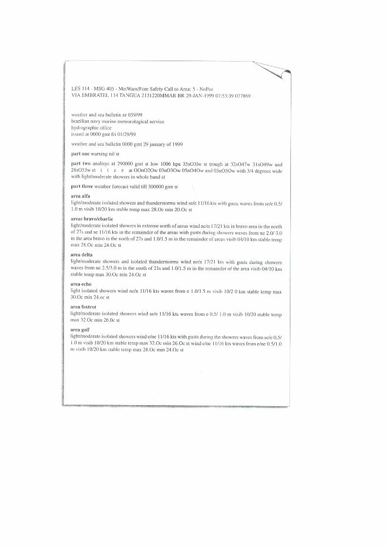
LES 102 - MSG 355 - MetWarn/Fore Safety Call to Area: 1 - NoPos
BT CSAT 23423440010402 15-JAN-1999 09:29:08 600998
SECURITE
HIGH SEAS WEATHER BULLETIN FOR METAREA 1 FROM BRACKNELL UNITED
KINGDOM ISSUED AT 0800 UTC FRI 15 JANUARY 1999
Part One: STORM WARNING
AT 150000UTC, LOW 58 NORTH 21 WEST 960 EXPECTED 62 NORTH 09 WEST
927 BY 160000UTC.
WINDS WILL REACH STORM FORCE 10 TO HURRICANE
FORCE 12 IN THE SOUTHERN SEMICIRCLE WITHIN 300 MILES OF THE
CENTRE.
WINDS WILL ALSO REACH STORM FORCE 10 IN THE NORTHWESTERN QUADRANT
WITHIN 300 MILES OF THE CENTER.
AT 150000UTC, LOW 63 NORTH 32 WEST 960 EXPECTED 58 NORTH 27 WEST
968 BY 160000UTC. WINDS WILL REACH STORM FORCE 10 IN THE
SOUTHWESTERN QUADRANT BETWEEN 100 MILES AND 350 MILES FROM THE
CENTRE.
WINDS WILL ALSO INCREASE TO STORM FORCE 10 IN THE DENMARK STRAIT
Part Two: GENERAL SYNOPSIS
AT 150000UTC, LOW 58 NORTH 21 WEST 960 EXPECTED 62 NORTH 09 WEST
927 BY 160000UTC.
LOW 63 NORTH 32 WEST 968 EXPECTED 58 NORTH 27
WEST 968 BY SAME TIME. HIGH 35 NORTH 30 WEST 1034 MOVING STEADILY
SOUTHWEST AND DECLINING, LOSING ITS IDENTITY BY THAT TIME
Part Three: AREA FORECASTS FOR NEXT 24 HOURS
SOUTHEAST ICELAND
EAST 6 OR 7 BACKING NORTHEAST GALE 8 TO STORM 10. SHOWERS THEN
RAIN. MODERATE OR POOR
EAST NORTHERN SECTION
IN NORTH, CYCLONIC IN EAST AT FIRST, OTHERWISE NORTH OR NORTHEAST
7 TO SEVERE GALE 9, OCCASIONALLY STORM 10 IN EAST AT FIRST.
SQUALLY WINTRY SHOWERS. MODERATE.
IN SOUTH, WESTERLY GALE 8 TO STORM 10, OCCASIONALLY VIOLENT STORM
11 TO HURRICANE FORCE 12 IN THE EAST AT FIRST, DECREASING 6 TO
GALE 8. WINTRY SHOWERS. MODERATE OR POOR
WEST CENTRAL SECTION
IN NORTH, WESTERLY GALE 8 TO STORM 10. SQUALLY WINTRY SHOWERS.
MODERATE OR GOOD. LIGHT ICING IN SOUTH, NORTHWESTERLY 7 TO SEVERE
GALE 9. SQUALLY WINTRY SHOWERS.
MODERATE OR GOOD
NORWEGIAN SEA AND DENMARK STRAIT
EAST OF 00 DEGS WEST, SOUTHEASTERLY 6 TO GALE 8 INCREASING SEVERE
GALE 9. WINTRY SHOWERS THEN RAIN. GOOD BECOMING MODERATE OR POOR.
FROM 10 DEGS WEST TO 00 DEGS WEST, SOUTHEASTERLY BACKING
NORTHEASTERLY 6 TO GALE 8 INCREASING SEVERE GALE 9. SNOW SHOWERS
THEN RAIN. MODERATE OR POOR.
WEST OF 10 DEGS WEST, NORTHEASTERLY 7 TO SEVERE GALE 9 ,
OCCASIONALLY STORM 10 IN THE DENMARK STRAIT AND FOR A TIME NEAR
NORTHEASTERN ICELAND. SNOW SHOWERS MODERATE OR POOR. TEMPERATURES
MS02 TO MS06 WITH MODERATE OR SEVERE ICING

IMO STANDARD MARINE COMMUNICATION PHRASES (SMCP 2001) III/3.1 - WARNINGS INVOLVING
METEOROLOGICAL AND HYDRO LOGICAL
CONDITIONS
3.1.1 - Winds, storms, tropical storms, sea state
What is wind direction and force in your position/in
position... ? - Wind direction ... (compass points), force Beaufort ...
in my position/in position...
Is wind backing/veering?
- Wind backing/veering.
Is wind expected to increase/decrease?
- Wind expected to increase/decrease.
What is latest gale warning?
- Latest gale warning is as follows: Gale warning.
Winds at... UTC in area ... (metarea) from direction ... (compass points) and force Beaufort ... backing/veering
to ...
What is atmospheric pressure in your position/in position... ?
- Atmospheric pressure... millibars.
What maximum winds are expected in storm area?
- Maximum winds of... knots expected in storm area.
What is sea state in your position/in position... ?
- Sea/swell in my position/in position ...... metres from ...
(compass points).
Is sea state expected to change (within next hours)?
- No, sea state not expected to change (within next hours). - Yes, sea/swell of... metres from ... (compass points)
expected (within next hours).

3.1.2 - Restricted visibility (due to mist/fog, precipitation)
What is visibility in your position/in position... ?
- Visibility in my position/in position ......
metres/nautical miles.
- Visibility reduced by mist/fog/snow/dust/rain.
- Visibility increasing/decreasing/variable.
Is visibility expected to change in my position/in position... (within next hours)?
- Yes, visibility expected to increase/decrease to ...
metres/nautical miles in your position/in position ... (within next hours).
What is latest ice information?
- Ice warning. Ice/iceberg(s) located in position...
/reported in area around … .

A. Comprehension & vocabulary
A.1 Decide whether the following statements are true or
false:
1. Meteorology is an exact science today. 2. A sudden change of pressure is an
important guide for the navigator. 3. In an anticyclone the winds are usually moderate. 4. A depression is basically a fair-weather system. 5. A depression has low air pressure in the centre. 6. Anticyclones are accompanied by heavy rain. 7. Anticyclones are predicted by a steadily rising barometer. 8. Cyclonic weather is predicted by a clearing sky. A.2 Supply the missing terms
• tropical storm • hectopascals • average • wind • heavy
• hectopascals • depression • falling • settled • weather
• moderate • pressure
1. Every rise in the ____________ does not foretell an
anticyclone and every fall does not foretell a ____________ .
2. Variations of three to four ____________ except in the tropics, are fairly normal.
3. Five hp above and steady or still rising barometer indicates ________________ weather with light to ____________ winds.
4. A barometer reading of five hectopascals, below normal, with the barometer still _____________ , is an indication of a period of unsettled ______________ .
5. In the tropics a fall of three mb below the _____________ needs to be treated with caution.
6. If it lasts for two or three days, it is a sure predication of a ______________ .
7. In other areas the pressure of less than 1000 _____________ , and the barometer falling rapidly at one hp per hour, indicates strong _____________ and _____________ rain.

A.3 Insert the following missing meteorological terms:
• heavy • visibility • veer • drizzle • front • direction
• warm • speed • cold • sky • rain • wind • approach
• speed • haze • sleet • cold front
1.In modern meteorological language wind-shift lines are
called ______________ ; three types of fronts are recognized: __________________ fronts, _____________ fronts, and occluded fronts.
2. The meteorological elements of special interest to the navigator are wind _____________, wind _____________ , appearance of the _____________ and frontal _____________ .
3. The ______________ of a well-defined warm front is indicated in middle and high latitudes by solidly overcast skies with more or less steady _______________ and diminishing _______________ . When the warm front arrives, the _____________________ veers rather suddenly, the rain stops or diminishes to a fine _____________ .
4. The conditions following the passage of a warm front are succeeded, sooner or later, by passage of a _____________ .
5. When this occurs, _____________ rain begins and the wind _____________ suddenly.
6. Precipitation of rain and snow or snow and hail is called _____________ .
7. In _____________ the visibility is reduced to about one mile.

A.4 Answer the following questions:
1. What does meteorology study? 2. What is it based on? 3. How can the navigator best predict the change in weather? 4. What is the atmospheric pressure measured with? Where? 5. What are the two main weather systems? 6. Describe an anticyclone: circulation of wind, pressure at
its centre, strength of winds, air, moving, forecasting anticyclones.
7. Describe a depression: circulation of wind, pressure, wind strength, air, moving, forecasting depressions.
A.5 Match the English terms of the Beaufort Wind Scale
with the Italian or your language equivalent (see
Beaufort Wind Scale, p. 84):


A.6 Working in pairs describe the two weather systems
ANTI-CYCLONE DEPRESSION
denotation on weather maps
Pressure in the centre
Wind change
Wind force
Type of Weather
Appearance of ther sky
Precipitations
Prediction

B. Grammar
B.1 Put the verbs in brackets into the Simple Present
(active or passive):
Tropical storms
Tropical storms (occur) _______________ in tropical and sub-tropical latitudes in all oceans. They (have) _____________ different names in different oceans. In the western North Atlantic, eastern North Pacific and western South Pacific they (know) _________________ as hurricanes. They (call) ____________ cyclones in the Arabian Sea, Bay of Bengal, South Indian Ocean and the vicinity of North-West Australia. In the western North Pacific they (refer) _______________ to as typhoons. A monsoon (not be) ______________ a tropical storm because it (be) ____________ a seasonal wind which (occur) __________________ in the Indian and western Pacific Oceans. In the Arabian Sea and in the China Sea a monsoon wind (reach) ______________ gale force.

B.2 Put the verbs in brackets into the Simple Past, the
Past Continuous or the Past Perfect Tense:
Hurricane «Gladys» (1975)
«Gladys» (follow) ____________ the disturbance from which the hurricane «Faye» (form) ____________ four days before. «Faye» (take) ____________ a more northerly track while «Gladys» (follow) ____________ the south-east along latitude 11°11' N. It (reach)
____________ tropical depression status near long. 35°00' W and tropical storm strength near long. 40°00' W.
It (reach) ____________ hurricane intensity before «Faye». As the hurricane (turn) ____________ to a northerly track the MS «Marconi Trader» (report) ____________ hurricane-force winds of 70 knots on October 1st. Twenty-four hours later at 18.00 hrs southerly winds of 60 knots (report) _____________ and a reconnaissance aircraft (measure) ____________ a central pressure of 939 mb and 120-knot wind. On the 2nd October the «Gladys» (accelerate) _____________ as it (pass)
____________ about 70 miles off Cape race. Widespread gales (cover) ____________ the western Atlantic as «Gladys» (merge) ____________ with a strong cold front.
A ship which (run) ____________ into a tropical storm three months earlier (report) ____________ 44-knot winds early that day.

B.3 Classify the words according to the pronunciation of
the stressed vowel:
• meteorology • weather • passage • atmosphere •
atmospheric • mercury • barometer • barometric •
anticyclone • depression • hemisphere • anticyclonic •
gradient • halo • hurricane • typhoon • monsoon • gale
• facsimile
B.4 Form adjectives from the following nouns (note the
shifting of stress):

C. Translation
C.1 Translate the following dialogue into English:
MV MISTRAL - Messina Radio. Messina Radio. Qui MV Mistral.
Quali sono le
condizioni del mare nella tua zona?
- MESSINA RADIO - Mistral. Mistral. Qui Messina Radio. La direzione prevista delle onde è 40 gradi.
MV MISTRAL - Quali condizioni del mare sonopreviste nella zona
15 gradi Nord e 12 gradi Ovest?
- MESSINA RADIO - Ci sono indicazioni di una forte depressione in formazione in posizione 15 gradi Nord ell Ovest. Ci si aspetta che la temperatura dell'aria scenda sotto zero. È prevista onda morta lunga debole. È prevista una riduzione di visibilità.
MV MISTRAL - Come cambia l'intensità e laforza del vento?
- MESSINA RADIO - II vento è in aumento. Dovreste cambiare rotta finché le
condizioni migliorano. MV MISTRAL - Ricevuto. Aspetterò finché il tempo migliora.

BEAUFORT WIND SCALE AND SEA DISTURBANCE
TABLE
Equivalent speed at 10 m above sea level
Mean Limits Description in forecasts
State of sea
Probable height of waves* metres
Force Description Specification for use at sea*
knots metres per
second
knots metres per
second
0 Calm Sea like a mirror. 0 0.0 <1 0.0-0.2 Calm Calm 0.0
1 Light air Ripples with the appearance of scales are formed, but without foam crests.
2 0.8 1-3
0.3-1.5 Light Calm 0.1 (0.1)
2 Light breeze Small wavelets, still short but more pronounced. Crests have a glassy appearance and do not break.
5 2.4 4-6 1.6-3.3 Light Smooth 0.2 (0.3)
3 Gentle breeze
Large wavelets. Crests begin to break. Foam of glassy appearance. Perhaps scattered white horses.
9 4.3 7-10 3.4-5.4 Light Smooth 0.6 (1.0)
4 Moderate breeze
Small waves, becoming longer, fairly frequent white horses.
13 6.7 11-16 5.5-7.9 Moderate Slight 1.0 (1.5)
5 Fresh breeze Moderate waves, taking a more pronounced long form; many white horses are formed. Chance of some spray
19 9.3 17-21 8.0-10.7
Fresh Moderate 2.0 (2.5)
6 Strong breeze
Large waves begin to form; the white foam crests are more extensive everywhere. Probably some spray.
24 12.3 22-27 10.8-13.8
Strong Rough 3.0 (4.0)
7 Near gale Sea heaps up and white foam from breaking waves begins to be blown in streaks along the direction of the wind.
30 15.5 28-33 13.9-17.1
Strong Very rough
4.0 (5.5)
8 Gale Moderately high waves of greater length; edges of crests begin to break into spindrift. The foam is blown in well-marked streaks along the direction of the wind.
37 18.9 34-40 17.2-20.7
Gale High 5.5 (7.5)
9 Strong gale High waves. Dense streaks of foam along the direction of the wind. Crests of waves begin to topple, tumble and roll over. Spray may affect visibility.
44 22.6 41-47 20.8-24.4
Severe gale Very high
7.0 (10.0)
10 Storm Very high waves with long overhanging crests. The resulting foam, in great patches, is blown in dense white streaks along the direction of the wind. On the whole, the surface of the sea takes a white appearance. The 'tumbling' of the sea becomes heavy and shock-like. Visibility affected.
52 26.4 48-55 24.5-28.4
Storm Very high
9.0 (12.5)
11 Violent storm
Exceptionally high waves (small and medium-sized ships might be lost to
60 30.5 56-63 28.5-32.6
Violent storm
Pheno-menal
11.5 (16.0)

view for a time behind the waves). The sea is completely covered with long white patches of foam lying along the direction of the wind. Everywhere the edges of the wave crests are blown into froth. Visibility affected.
12 Hurricane The air is filled with foam and spray. Sea completely white with driving spray; visibility seriously affected.
- - 64 and over
32.7 and over
Hurricane force
Pheno-menal
14.0 (-)
* These columns are a guide to show roughly what may be expected in the open sea, remote from land. Figures in brackets indicate the probable maximum height of waves. In enclosed waters, or when near land with an offshore wind, wave heights will be smaller and the waves steeper.
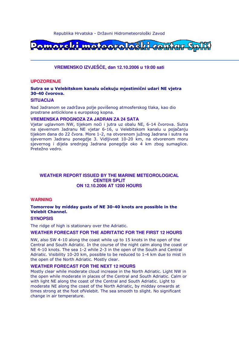
Republika Hrvatska - Državni Hidrometeorološki Zavod
VREMENSKO IZVJEŠĆE, dan 12.10.2006 u 19:00 sati
UPOZORENJE
Sutra se u Velebitskom kanalu očekuju mjestimični udari NE vjetra 30-40 čvorova.
SITUACIJA
Nad Jadranom se zadržava polje povišenog atmosferskog tlaka, kao dio prostrane anticiklone s europskog kopna.
VREMENSKA PROGNOZA ZA JADRAN ZA 24 SATA Vjetar uglavnom NW, tijekom noći i jutra uz obalu NE, 6-14 čvorova. Sutra na sjevernom Jadranu NE vjetar 6-16, u Velebitskom kanalu u pojačanju tijekom dana do 22 čvora. More 1-2, na otvorenom južnog Jadrana i sutra na sjevernom Jadranu ponegdje 3. Vidljivost 10-20 km, na otvorenom moru sjevernog i dijela srednjeg Jadrana ponegdje oko 4 km zbog sumaglice. Pretežno vedro.
WEATHER REPORT ISSUED BY THE MARINE METEOROLOGICAL CENTER SPLIT
ON 12.10.2006 AT 1200 HOURS
WARNING
Tomorrow by midday gusts of NE 30-40 knots are possible in the Velebit Channel.
SYNOPSIS
The ridge of high is stationary over the Adriatic.
WEATHER FORECAST FOR THE ADRITATIC FOR THE FIRST 12 HOURS
NW, also SW 4-10 along the coast while up to 15 knots in the open of the Central and South Adriatic. In the course of the night calm along the coast or NE 4-10 knots. The sea 1-2 while 2-3 in the open of the South and Central Adriatic. Visibility 10-20 km, possible to be reduced to 1-4 km due to mist in the open of the North Adriatic. Mostly clear.
WEATHER FORECAST FOR THE NEXT 12 HOURS Mostly clear while moderate cloud increase in the North Adriatic. Light NW in the open while moderate in places of the Central and South Adriatic. Calm or with light NE along the coast of the Central and South Adriatic. Light to moderate NE along the coast of the North Adriatic, by midday onwards at times strong at the foot ofVelebit. The sea smooth to slight. No significant change in air temperature.
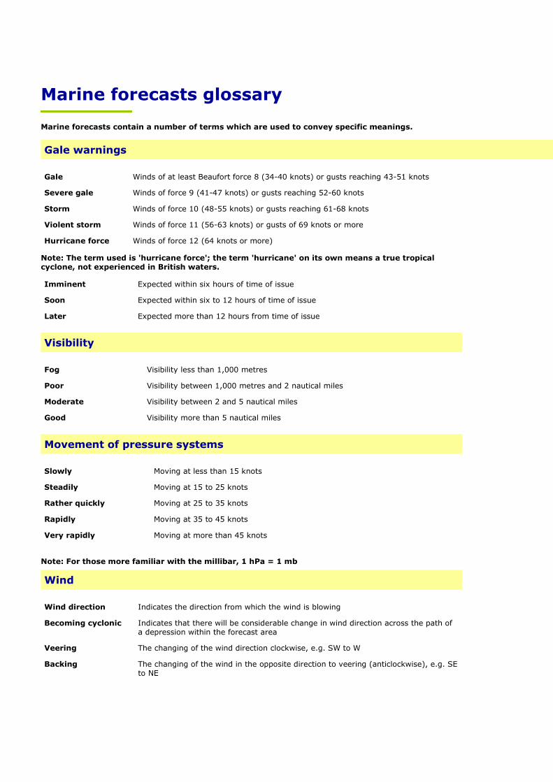
Marine forecasts glossary
Marine forecasts contain a number of terms which are used to convey specific meanings.
Gale warnings
Gale Winds of at least Beaufort force 8 (34-40 knots) or gusts reaching 43-51 knots
Severe gale Winds of force 9 (41-47 knots) or gusts reaching 52-60 knots
Storm Winds of force 10 (48-55 knots) or gusts reaching 61-68 knots
Violent storm Winds of force 11 (56-63 knots) or gusts of 69 knots or more
Hurricane force Winds of force 12 (64 knots or more)
Note: The term used is 'hurricane force'; the term 'hurricane' on its own means a true tropical cyclone, not experienced in British waters.
Imminent Expected within six hours of time of issue
Soon Expected within six to 12 hours of time of issue
Later Expected more than 12 hours from time of issue
Visibility
Fog Visibility less than 1,000 metres
Poor Visibility between 1,000 metres and 2 nautical miles
Moderate Visibility between 2 and 5 nautical miles
Good Visibility more than 5 nautical miles
Movement of pressure systems
Slowly Moving at less than 15 knots
Steadily Moving at 15 to 25 knots
Rather quickly Moving at 25 to 35 knots
Rapidly Moving at 35 to 45 knots
Very rapidly Moving at more than 45 knots
Note: For those more familiar with the millibar, 1 hPa = 1 mb
Wind
Wind direction Indicates the direction from which the wind is blowing
Becoming cyclonic
Indicates that there will be considerable change in wind direction across the path of a depression within the forecast area
Veering The changing of the wind direction clockwise, e.g. SW to W
Backing
The changing of the wind in the opposite direction to veering (anticlockwise), e.g. SE to NE