unit 2.1 plate tectonics -...
TRANSCRIPT

1
Unit 2.1 Plate Tectonics
Tick off those you feel confident about:
Be able to describe the general distribution of fold mountains, volcanoes and earthquakes
Be able to explain how the distribution of fold mountains, volcanoes and earthquakes is related to movements at plate boundaries.
Be able to describe the global pattern of plates and their structures
Be able to explain why plates move and the effect this has at the plate margins
Know the types of plate boundaries - constructive; collision (destructive/subduction and continental collision) and conservative
Know what happens at the different plate boundaries and what landforms are found at the different plate boundaries.
Know the main features of volcanoes and their structures
Know why people choose to live near volcanoes and where there are earthquakes
Be able to explain how and why earthquakes affect MEDCs differently from LEDCs
Know a case study of an MEDC earthquake (where, when, why it happened, the effects)
Know a case study of an LEDC earthquake (where, when, why it happened, the effects)
Know a case study of a volcano (where, when, why it happened, the effects)

2
The Earth is made up of four distinct layers:
The inner core is in the centre and is the hottest part of the Earth. It is solid and made up of iron
and nickel with temperatures of up to 5500°C. With its immense heat energy, the inner core is
like the engine room of the Earth.
The outer core is the layer surrounding the inner core. It is a liquid layer, also made up of iron
and nickel. It is still extremely hot, with temperatures similar to the inner core.
The mantle is the widest section of the Earth. It has a diameter of approximately 2900km. The
mantle is made up of semi-molten rock called magma. In the upper parts of the mantle the rock
is hard, but lower down the rock is soft and beginning to melt.
The crust is the outer layer of the earth. It is a thin layer between 0-60km thick. The crust is the
solid rock layer upon which we live.
There are two different types of crust: continental crust, which carries land, and oceanic crust, which
carries water.
The diagram below shows the structure of the earth. In geography, taking a slice through a structure to
see inside is called a cross section.
Cross section showing structure of the Earth
Distribution
The Earth's crust is broken up into pieces called plates. Heat rising and falling inside the mantle creates
convection currents generated by radioactive decay in the core. The convection currents move the

3
plates. Where convection currents diverge near the Earth's crust, plates move apart. Where convection
currents converge, plates move towards each other. The movement of the plates, and the activity inside
the Earth, is called plate tectonics.
Plate tectonics cause earthquakes and volcanoes. The point where two plates meet is called a plate
boundary. Earthquakes and volcanoes are most likely to occur either on or near plate boundaries.
The Earth's plates move in different directions
Plates behave differently at different plate boundaries:
At a constructive or divergent boundary the plates move apart.
At a destructive or convergent boundary the plates move towards each other.
At a conservative or transform boundary the plates slide past each other.
Different exam boards and textbooks may use different names for each of the boundary types. For
example, a destructive boundary may also be called a collision boundary. Use any term so long as you
use it correctly, but it is best to stick to the terms you have been taught.
Divergent Boundary
At a divergent or constructive boundary the plates are moving apart. The plates move apart due to
convection currents inside the Earth.
The Helgafjell volcano on Westmann Island, Iceland
As the plates move apart (very slowly), magma rises from the mantle. The magma erupts to the surface
of the Earth. This is also accompanied by earthquakes.
When the magma reaches the surface, it cools and solidifies to form a new crust of igneous rock. This
process is repeated many times, over a long period of time.
Eventually the new rock builds up to form a volcano. Constructive boundaries tend to be found under
the sea, eg the Mid-Atlantic Ridge. Here, chains of underwater volcanoes have formed along the plate
boundary. One of these volcanoes may become so large that it erupts out of the sea to form a volcanic
island, e.g. Surtsey and the Westman Islands near Iceland.
The diagram below to see how magma pushes up between the two plates, causing a chain of volcanoes
along the constructive plate boundary.

4
Convergent boundary
At a convergent or destructive boundary the plates are moving towards each other. This usually involves
a continental plate and an oceanic plate.
The oceanic plate is denser than the continental plate so, as they move together, the oceanic plate is
forced underneath the continental plate. The point at which this happens is called the subduction zone.
As the oceanic plate is forced below the continental plate it melts to form magma and earthquakes are
triggered. The magma collects to form a magma chamber. This magma then rises up through cracks in the
continental crust. As pressure builds up, a volcanic eruption may occur.
A view of the Himalayas from Gorak Shep
As the plates push together, the continental crust is squashed together and forced upwards. This is called
folding. The process of folding creates fold mountains. Fold mountains can also be formed where two
continental plates push towards each other. This is how mountain ranges such as the Himalayas and the
Alps were formed. Fold mountains occur near convergent plate boundaries. Examples of fold mountains
include the Alps, Rockies, Andes and Himalayas.
Formation and characteristics
The formation of fold mountains
The formation of fold mountains
Where an area of sea separates two plates, sediments settle on the sea floor in depressions
called geosynclines. These sediments gradually become compressed into sedimentary rock.

5
When the two plates move towards each other again, the layers of sedimentary rock on the sea
floor become crumpled and folded.
Eventually the sedimentary rock appears above sea level as a range of fold mountains.
Earthquakes
Earthquakes are caused by the release of built-up pressure inside the Earth's crust. An earthquake's
power is measured on the Richter Scale using an instrument called a seismometer. The effects of an
earthquake can be devastating - they can destroy settlements, change landscapes, and cause many
deaths.
Causes
An earthquake is the shaking and vibration of the Earth's crust due to movement of the Earth's plates
(plate tectonics). Earthquakes can happen along any type of plate boundary.
Earthquakes occur when tension is released from inside the crust. Plates do not always move smoothly
alongside each other and sometimes get stuck. When this happens pressure builds up. When this
pressure is eventually released, an earthquake tends to occur.
The point inside the crust where the pressure is released is called the focus. The point on the Earth's
surface above the focus is called the epicentre.
Earthquake energy is released in seismic waves. These waves spread out from the focus. The waves are
felt most strongly at the epicentre, becoming less strong as they travel further away. The most severe
damage caused by an earthquake will happen close to the epicentre.
Diagram of an earthquake
Measurement of earthquakes

6
The aftermath of an earthquake, Golcuk, Western Turkey
The power of an earthquake is measured using a seismometer. A seismometer detects the vibrations
caused by an earthquake. It plots these vibrations on a seismograph.
The strength, or magnitude, of an earthquake is measured using the Richter scale. The Richter scale is
numbered 0-10:
Earthquakes measuring just one or two on the scale are very common and can happen everyday
in places like San Francisco. These earthquakes are so small that people cannot feel them, they
can only be picked up by a seismometer.
Earthquakes measuring around seven or eight on the Richter scale can be devastating. The
earthquake in China's south-western Sichuan province in May 2008 measured 7.8 on the Richter
scale.
Effects of an earthquake
Clearing rubble after an earthquake, Bhuj, India
Earthquakes can destroy settlements and kill many people. Aftershocks can cause even more damage to
an area. It is possible to classify the impacts of an earthquake, by taking the following factors into
account:
short-term (immediate) impacts
long-term impacts
social impacts (the impact on people)
economic impacts (the impact on the wealth of an area)
environmental impacts (the impact on the landscape)

7
Social impacts Economic impacts Environmental impacts
Short-term (immediate) impacts
People may be killed or injured. Homes may be destroyed. Transport and communication links may be disrupted. Water pipes may burst and water supplies may be contaminated.
Shops and business may be destroyed. Looting may take place. The damage to transport and communication links can make trade difficult.
The built landscape may be destroyed. Fires can spread due to gas pipe explosions. Fires can damage areas of woodland. Landslides may occur. Tsunamis may cause flooding in coastal areas.
Long-term impacts
Disease may spread. People may have to be re-housed, sometimes in refugee camps.
The cost of rebuilding a settlement is high. Investment in the area may be focused only on repairing the damage caused by the earthquake. Income could be lost.
Important natural and human landmarks may be lost.
Effects are often classified as primary and secondary impacts. Primary effects occur as a direct result of
the ground shaking, eg buildings collapsing. Secondary effects occur as a result of the primary effects,
eg tsunamis or fires due to ruptured gas mains.
Factors affecting the impact of an earthquake
Distance from the epicentre – the effects of an earthquake are more severe at its centre.
The higher on the Richter scale, the more severe the earthquake is.
Level of development – MEDCs are more likely to have the resources and technology for
monitoring, prediction and response.
Population density (rural or urban area). The more densely populated an area, the more likely
there are to be deaths and casualties.
Communication - accessibility for rescue teams.
Time of day influenceS whether people are in their homes, at work or travelling. A severe
earthquake at rush hour in a densely populated urban area could have devastating effects.
The time of year and climate will influence survival rates and the rate at which disease can
spread.

8
Earthquakes and volcanoes in LEDCs
LEDCs often suffer more from the effects of volcanoes and earthquakes than MEDCs
The effects of an earthquake or a volcano in LEDCs
Communication systems may be underdeveloped, so the population may not be well educated
about what to do in the event of a volcanic eruption or an earthquake.
Construction standards tend to be poor in LEDCs. Homes and other buildings may suffer serious
damage when a disaster occurs.
Buildings collapsing can cause high death tolls.
Evacuation and other emergency plans can be difficult to put into action due to limited funds and
resources.
Clearing up can be difficult. There may not be enough money to rebuild homes quickly and safely.
Many people could be forced to live in emergency housing or refugee camps.
Case studies
Kobe, Japan, 1995 – MEDC
On 17th January 1995, an earthquake struck Kobe, a heavily populated urban area in Japan. It measured
7.4 on the Richter scale and occurred as a result of plate movement along the boundary between the
Philippines Plate, Pacific Plate and Eurasian Plate.
Effects: Key Fact - primary effects happen immediately. Secondary effects usually occur as a result of the
primary effects.
Primary effects Secondary effects
35000 people injured.
Buildings and bridges collapsed despite their earthquake proof design.
Buildings destroyed by fire when the gas mains fractured.
316000 people left homeless and refugees moved into temporary housing.
Responses
These can be divided into short and long term.
Short term Long term
People were evacuated and emergency rations provided.
Rescue teams searched for survivors for 10 days.
Many people moved away from the area permanently.
Jobs were created in the construction industry as part of a rebuilding programme.
9
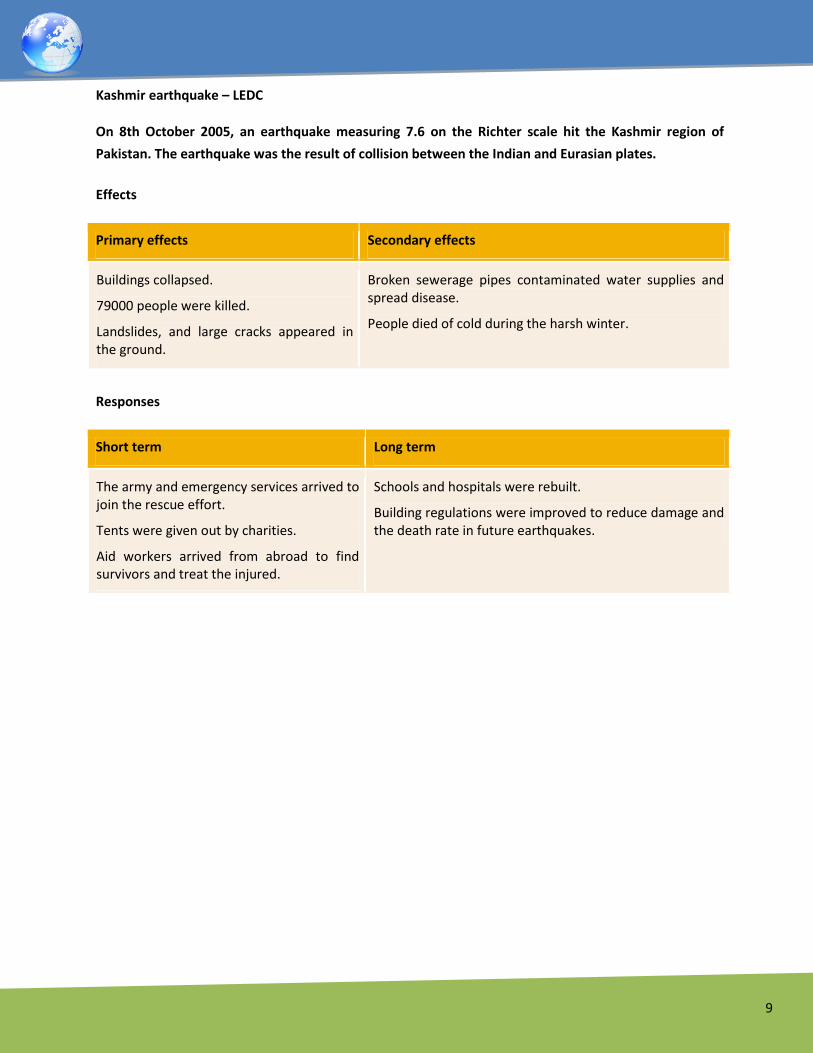
Kashmir earthquake – LEDC
On 8th October 2005, an earthquake measuring 7.6 on the Richter scale hit the Kashmir region of
Pakistan. The earthquake was the result of collision between the Indian and Eurasian plates.
Effects
Primary effects Secondary effects
Buildings collapsed.
79000 people were killed.
Landslides, and large cracks appeared in the ground.
Broken sewerage pipes contaminated water supplies and spread disease.
People died of cold during the harsh winter.
Responses
Short term Long term
The army and emergency services arrived to join the rescue effort.
Tents were given out by charities.
Aid workers arrived from abroad to find survivors and treat the injured.
Schools and hospitals were rebuilt.
Building regulations were improved to reduce damage and the death rate in future earthquakes.

10
Volcanoes
Volcanoes form when magma reaches the Earth's surface, causing eruptions of lava and ash. They occur
at destructive and constructive plate boundaries.
The immediate effects of volcanic eruptions can be devastating, but they may be beneficial in the long
term.
Facts:
Key things you should know about volcanoes:
A volcano is formed by eruptions of lava and ash.
Volcanoes are usually cone shaped mountains or hills.
When magma reaches the Earth's surface it is called lava. When the lava cools, it forms rock.
Volcanic eruptions can happen at destructive and constructive boundaries, but not at
conservative boundaries.
Some volcanoes happen underwater, along the seabed or ocean floor.
How volcanoes form
Magma rises through cracks or weaknesses in the Earth's crust.
Pressure builds up inside the Earth.
When this pressure is released, e.g. as a result of plate movement, magma explodes to the
surface causing a volcanic eruption.
The lava from the eruption cools to form new crust.
Over time, after several eruptions, the rock builds up and a volcano forms
Inside a volcano

11
The magma chamber is a collection of magma inside the Earth, below the volcano.
The main vent is the main outlet for the magma to escape.
Secondary vents are smaller outlets through which magma escapes.
The crater is created after an eruption blows the top off the volcano.
An eruption occurs when pressure in the magma chamber forces magma up the main vent,
towards the crater at the top of the volcano. Some magma will also be forced out of the
secondary vent at the side of the volcano.
Different types of volcano
Volcanoes can be described in terms of activity and can be:
Still active and erupt frequently.
Dormant (temporarily inactive but not fully extinct).
Extinct (never likely to erupt again).
Volcanoes can also be described by their shape or type:
Shield volcanoes
The characteristics of a shield volcano
Shield volcanoes are usually found at constructive boundaries.
They are low, with gently sloping sides.
They are formed by eruptions of thin, runny lava.
Eruptions tend to be frequent but relatively gentle.

12
Strato volcanoes
Characteristics of a composite volcano
Composite volcanoes are made up of alternating layers of lava and ash (other volcanoes just
consist of lava).
They are usually found at destructive boundaries.
The eruptions from these volcanoes may be a pyroclastic flow rather than a lava flow. A
pyroclastic flow is a mixture of hot steam, ash, rock and dust.
A pyroclastic flow can roll down the sides of a volcano at very high speeds and with temperatures
of over 400° C.
Effects of volcanic eruptions
Helgafjell Volcano, Iceland
Volcanic eruptions can have a devastating effect on people and the environment.
However, unlike earthquakes, volcanoes can also have a positive impact on an area. These positive
impacts can help to explain why people choose to live near volcanoes.

13
Positive and negative effects of an eruption
Positive Negative
The dramatic scenery created by volcanic eruptions attracts tourists. This brings income to an area.
Many lives can be lost as a result of a volcanic eruption.
The lava and ash deposited during an eruption breaks down to provide valuable nutrients for the soil. This creates very fertile soil which is good for agriculture
If the ash and mud from a volcanic eruption mix with rain water or melting snow, fast moving mudflows are created. These flows are called lahars.
The high level of heat and activity inside the Earth, close to a volcano, can provide opportunities for generating geothermal energy.
Lava flows and lahars can destroy settlements and clear areas of woodland or agriculture.
Human and natural landscapes can be destroyed and changed forever.
Case study: Chances Peak, Montserrat, 1995-97 – an LEDC
Plymouth covered in ash from volcanic eruptions on Montserrat
Montserrat is a small island in the Caribbean. There is a volcanic area located in the south of the island on
Soufriere Hills called Chances Peak. Before 1995 it had been dormant for over 300 years. In 1995 the
volcano began to give off warning signs of an eruption (small earthquakes and eruptions of dust and
ash). Once Chances Peak had woken up it then remained active for five years. The most intense eruptions
occurred in 1997.
During this time, Montserrat was devastated by pyroclastic flows. The small population of the island
(11,000 people) was evacuated in 1995 to the north of Montserrat as well as to neighbouring islands and
the UK.
Despite the evacuations, 19 people were killed by the eruptions as a small group of people chose to stay
behind to watch over their crops.
Volcanic eruptions and lahars have destroyed large areas of Montserrat. The capital, Plymouth, has been
covered in layers of ash and mud. Many homes and buildings have been destroyed, including the only
hospital, the airport and many roads.
The graphic shows the progress of the eruption and its impact on the island.

14
Montserrat - eruption progress and impact
Short-term responses and results
Evacuation.
Abandonment of the capital city.
The British government gave money for compensation and redevelopment.
Unemployment rose due to the collapse of the tourist industry.
Long-term responses and results
An exclusion zone was set up in the volcanic region.
A volcanic observatory was built to monitor the volcano.
New roads and a new airport were built.
Services in the north of the island were expanded.
The presence of the volcano resulted in a growth in tourism.
Volcanic activity has calmed down in recent years and people have begun to return to the island.
You might be asked to consider the values and attitudes or opinions of people involved in the eruption as
refugees or aid workers for example.

15
Case study: Mount St Helens 1980 – an MEDC
Map showing location of Mount St Helens
Mount St Helens is on the plate boundary between the Juan de Fuca plate and North American plate.
When it erupted it permanently changed the surrounding landscape.
Effects of the eruption
Primary effects Secondary effects
Pyroclastic flows (hot ash and gas) destroyed forests and logging camps.
63 people were killed, mainly by poisonous gases.
Lahars (mudflows of ash and water) covered an extensive area surrounding the volcano.
Ash blocked rivers destroying popular fishing sites and causing flooding. This in turn destroyed crops and livestock.
Flooding destroyed communications such as road and railway bridges.
Sediment carried downstream ruined barge transport on the Columbia River.
Short term responses and results
Communications such as roads and bridges were repaired.
People were rehoused.
Long term responses and results
Soil fertility improved due to the ash deposits.
The volcano is now more carefully monitored.
Tourism has increased, boosting the local economy.
It's not possible to prevent earthquakes and volcanic eruptions. However, careful management of these
hazards can minimise the damage that they cause. Prediction is the most important aspect of this, as this
gives people time to evacuate the area and make preparations for the event.

16
Predicting and preparing for volcanoes
Unfortunately volcanic eruptions and earthquakes cannot be prevented.
Managing hazards such as earthquakes and volcanoes can be done by: prediction and preparation.
As a volcano becomes active, it gives off a number of warning signs. These warning signs are picked up by
volcanologists (experts who study volcanoes) and the volcano is monitored.
The key techniques for monitoring a volcano
Warning signs Monitoring techniques
Hundreds of small earthquakes are caused as magma rises up through cracks in the Earth's crust.
Seismometers are used to detect earthquakes.
Temperatures around the volcano rise as activity increases. Thermal imaging techniques and satellite cameras can be used to detect heat around a volcano
When a volcano is close to erupting it starts to release gases. The higher the sulfur content of these gases, the closer the volcano is to erupting.
Gas samples may be taken and chemical sensors used to measure sulphur levels.
The techniques available for predicting and monitoring volcanic activity are becoming increasingly
accurate. Volcanoes such as Mount St Helens in the USA and Mount Etna in Italy are closely monitored
at all times. This is because they have been active in recent years and people who live nearby would
benefit from early-warning signs of an eruption. However, as well as prediction, people need to be
prepared for an eruption.
Preparing for an eruption
A detailed plan is needed for dealing with a possible eruption. Everyone who could be affected needs to
know the plan and what they should do if it needs to be put into action. Planning for a volcanic eruption
includes:
Creating an exclusion zone around the volcano.
Being ready and able to evacuate residents.
Having an emergency supply of basic provisions, such as food.
Funds need to be available to deal with the emergency and a good communication system needs
to be in place.
Predicting and preparing for earthquakes

17
Earthquakes are not as easy to predict as volcanic eruptions. However, there are still some ways of
monitoring the chances of an earthquake:
Laser beams can be used to detect plate movement.
A seismometer is used to pick up the vibrations in the Earth's crust. An increase in vibrations may
indicate a possible earthquake.
Radon gas escapes from cracks in the Earth's crust. Levels of radon gas can be monitored - a
sudden increase may suggest an earthquake.
Many of the prediction techniques used to monitor earthquakes are no 100% reliable. Planning
and preparing for an earthquake is therefore very important.
People living in earthquake zones need to know what they should do in the event of a quake.
Training people my involve holding earthquake drills and educating people via TV or radio.
People may put together emergency kits and store them in their homes. An emergency kit may
include first-aid items, blankets and tinned food.
Earthquake proof buildings have been constructed in many major cities, eg The Transamerica
Pyramid in San Francisco. Buildings such as this are designed to absorb the energy of an
earthquake and to withstand the movement of the Earth.
Roads and bridges can also be designed to withstand the power of earthquakes.