united nations statistical division workshop on census cartography and management bangkok, thailand...
TRANSCRIPT

United Nations Statistical DivisionUnited Nations Statistical DivisionWorkshop on Census Cartography and ManagementWorkshop on Census Cartography and Management
Bangkok, ThailandBangkok, Thailand15-19 Oct 200715-19 Oct 2007
Field Data Collection Utilizing “ArcPad” Field Data Collection Utilizing “ArcPad” (software for hand-held devices)(software for hand-held devices)
Dr.Sukit ViseshsinDr.Sukit Viseshsin
ESRI (Thailand) Co.,Ltd.ESRI (Thailand) Co.,Ltd.
[email protected]@cdg.co.th

OutlineOutline
• Who we are?Who we are?
• What is ArcPad?What is ArcPad?
• What can ArcPad do?What can ArcPad do?
• ArcPad DemonstrationArcPad Demonstration

ESRI
• Founded in 1969 (38 Years)Founded in 1969 (38 Years)• Privately OwnedPrivately Owned• Zero DebtZero Debt• Focused Strictly on Geographic Information Systems (GIS) Focused Strictly on Geographic Information Systems (GIS) • Ranked as one of the Top Software Companies in the WorldRanked as one of the Top Software Companies in the World• Over 1 Million Users GloballyOver 1 Million Users Globally

What is ArcPadWhat is ArcPad
• GIS & Field collection software for mobile / hand-held GIS & Field collection software for mobile / hand-held devicesdevices
• Rich functionalitiesRich functionalities• Many devices supportedMany devices supported• CustomizableCustomizable
ArcPadArcPad
General Purpose General Purpose (Strong GPS Integration)(Strong GPS Integration)
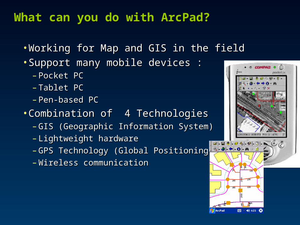
What can you do with ArcPad?What can you do with ArcPad?
• Working for Map and GIS in the fieldWorking for Map and GIS in the field• Support many mobile devices :Support many mobile devices :
– Pocket PCPocket PC– Tablet PCTablet PC– Pen-based PCPen-based PC
• Combination ofCombination of 4 Technologies 4 Technologies – GIS (Geographic Information System)GIS (Geographic Information System)– Lightweight hardwareLightweight hardware– GPS Technology (Global Positioning System)GPS Technology (Global Positioning System)– Wireless communicationWireless communication

Using your existing data, Capturing data in the fieldUsing your existing data, Capturing data in the field
What can you do with ArcPad?What can you do with ArcPad?

Moving around your map,Moving around your map, Querying your dataQuerying your data
What can you do with ArcPad?What can you do with ArcPad?

Measuring distances on your map, Navigating with your Measuring distances on your map, Navigating with your GPSGPS
What can you do with ArcPad?What can you do with ArcPad?

Editing your dataEditing your data
What can you do with ArcPad?What can you do with ArcPad?

• Using ArcPad Application BuilderUsing ArcPad Application Builder• Customization can beCustomization can be ::
– Input form designInput form design– DataData validationvalidation– CustomizeCustomize Application for userApplication for user– Script withScript with ArcPad objectsArcPad objects– Etc…Etc…
Customizing ArcPadCustomizing ArcPad

Other Windows CE DevicesOther Windows CE Devices
Pocket PC IndustrialRuggedField PC
PocketGoodsWindow Case
Or Surveyors
CaseLeica’s GS5/5+ package is bundled with Panasonic Toughbook 01 Windows CE handheld device

Microsoft ActiveSync
ArcPad Connection

Maps and layersMaps and layers

Maps and layersMaps and layers

Edit toolbarEdit toolbar Command barCommand bar
ArcPad toolbarsArcPad toolbars

Zooming and panningZooming and panning Zooming with the fixed zoom tool Zooming with the fixed zoom tool
Moving around the mapMoving around the map

Customizing ArcPadCustomizing ArcPad
• ArcPad Application BuilderArcPad Application Builder
Tree View
Script EditorForm Designer
Control Properties
Tool Palette
Toolbar Designer & Manager

Sample ApplicationSample Application

Personal Database and Medical Treatment Record integrated with map Personal Database and Medical Treatment Record integrated with map
Orthophoto Map

Pocket PC Pocket PC Digital Camera Digital Camera
GPS GPS
Collect coordinates of all building types by GPS, included personal attribute and picturesCollect coordinates of all building types by GPS, included personal attribute and pictures
E-Care Project

Map for House location and picture
Map for House location and picture
#
ÇÑ˹ͧâ¾Ôì
มาตราส�วน 1:4000,
;
;
;
;
;
;
;;;
;
;
;;
;
;
;
;
;
;
;;;
;
;
; ;; ;
;
;
;
;
; ;
;
;
;
;;
;
;
;; ;
; ;
;; ; ; ;
; ;
; ;
;
;
;
;;
;;
;;
;
;
;
;
;
;
;
;
;
;
;
;
;
;
;
;;
;
;
;
;
;
;
;
;
;
;
;
;;
;
;
;
;;
;
«Ù
Á¹
ºØ
ÁÕ
Ó
¾¹Á
á§
ËèÁ·ÇÕ
͹Ø
âÁ
ÊÇÔ§
ÇÔéÇÊÁ¾Ù
¶ÇÔÅ
ÊÇÒ·
àÔÁ
©Åͧ
½éÒÂ
ªØèÁ¡éÒ¹
¾Âا
ÅÓãÂÂؾÒ
¶¹ÍÁ ÍÒÃÕ
¡è͹
ÊÁ¾Ã
¡é͹
ÁÒ¹¾
ÊÇèÒ§
Êǧ¤ì ѹäµ
ºØ ªÙÊÁºØ
ÊÁªÒÂ
ÊÒËÑ
ÊÒËÑ
à¹×ͧ
ºØÉÂÒÓÃÑÊ
»ÃÐä¾ÅÓǹ
ÃÓ¾Ö§ÅÓÂͧ
ÀÑÊÊÃ
ºÃçÀÒÇÕÊÕä¾Ã
ÇÒʹÒ
ÊØà·¾
Êع·Ã
¾ÑªÃÕ
ÊÁ¹Ö¡
¤Ó¡Í§ ÓÃÔµ
ÊÓàÃÔ§
»·ØÁÁÒ
·Í§¾Ù¹
͹تԵ
Ó¹§¤ìÍÒÃÕÂì
¡Ò ¹Ò
»ÃÒÔ¹
ÊÁÔµÃ
ÊÁÔµÃì
»ÃÐʧ¤ì
ºØà¡Ô
¹ÒÀóì
ÇÊÇѵµì
¡ÔÁ¡Øè ºØ ÃÃÁ
ÊØÃѵ¹ì
¾ÅÇѲ¹ì¹éÓ¼Öé§
ºØàÃ×͹
ÊÑÁÄ· Ôì ÀÙÁÔ¹·ÃìÊÁÈÑ¡ Ôì
»ÃÐÊÔ· Ôì
ÇÔÅÒÇÑÅÂì
ÃÒªÈÑ¡ Ôì
ÊؾÃóÈÃÕ
¾§ÉìÈÑ¡ Ôì
ZoominZoomin

Residential Information in each house and picture Residential Information in each house and picture

House Information and picture House Information and picture

2470
Residential Information and picture Residential Information and picture

Let’s make sure that everyone counts!Let’s make sure that everyone counts!..and is counted!..and is counted!
Source: World Resources Institute
Source: Robert Ford, LLU
Source: doae.go.th

Thank you!Thank you!