united states department of agriculture site occurs on steep slopes and ridge tops, but may occur...
TRANSCRIPT
Site Type: Rangeland Very Shallow (VS) 5-9 WR MLRA: 32 – Northern Intermountain Basins R032XY276WY
United States Department of Agriculture Natural Resources Conservation Service
Ecological Site Description
Site Type: Rangeland Site Name: Very Shallow (VS) 5-9” Wind River Basin Precipitation Zone Site ID: R032XY276WY Major Land Resource Area: 32 – Northern Intermountain Desertic Basins Physiographic Features This site occurs on steep slopes and ridge tops, but may occur on all slopes. Landform: Hillsides, ridges & escarpments Aspect: N/A
Minimum Maximum Elevation (feet): 4500 6600 Slope (percent): 0 60 Water Table Depth (inches): None within 60 inches Flooding: Frequency: None None Duration: None None Ponding: Depth (inches): 0 0 Frequency: None None Duration: None None Runoff Class: negligible high Climatic Features Annual precipitation ranges from 5-9 inches per year. The normal precipitation pattern shows peaks in May and June and a secondary peak in September. This amounts to about 50% of the mean annual precipitation. Much of the moisture that falls in the latter part of the summer is lost by evaporation and much of the moisture that falls during the winter is lost by sublimation. Average snowfall is about 20 inches annually. Wide fluctuations may occur in yearly precipitation and result in more dry years than those with more than normal precipitation.
Temperatures show a wide range between summer and winter and between daily maximums and minimums, due to the high elevation and dry air, which permits rapid incoming and outgoing radiation. Cold air outbreaks from Canada in winter move rapidly from northwest to southeast and account for extreme minimum temperatures. Chinook winds may occur in winter and bring rapid rises in temperature. Extreme storms may occur during the winter, but most severely affect ranch operations during late winter and spring. High winds are generally blocked from the basin by high mountains, but can occur in conjunction with an occasional thunderstorm. Growth of native cool-season plants begins about April 1 and continues to about July 1. Cool weather and moisture in September may produce some green up of cool season plants that will continue to late October.
Technical Guide USDA NRCS Section IIE Rev. 03/11/05
Site Type: Rangeland Very Shallow (VS) 5-9 WR MLRA: 32 – Northern Intermountain Basins R032XY276WY
The following information is from the “Pavillion” climate station: Minimum Maximum 5 yrs. out of 10 between Frost-free period (days): 95 175 May 19 – September 19 Freeze-free period (days): 98 185 May 6 – October 3 Mean Annual Precipitation (inches): 2.50 12.54 Mean annual precipitation: 7.85 inches Mean annual air temperature: 44.53°F (30.5°F Avg. Min. to 58.5°F Avg. Max.) For detailed information visit the Natural Resources Conservation Service National Water and Climate Center at http://www.wcc.nrcs.usda.gov/ website. Other climate station(s) representative of this precipitation zone include” Riverton”, “Arminto”, and “Lost Cabin”. Influencing Water Features Wetland Description: System Subsystem Class Sub-class None None None None None Stream Type: None Representative Soil Features The soils of this site are very shallow (less than 10” to bedrock) well-drained soils formed in residuum. These soils have rapid to slow permeability and can be of any texture. This site usually occurs on steep slopes, but may be on any slope. The bedrock will include all kinds except soft clay shales, igneous and some volcanic. The soil characteristic having the most influence on the plant community is the very shallow depth to bedrock, which drastically limits the available moisture. Major Soil Series correlated to this site include: Other Soil Series in MLRA 32 correlated to this site include: Parent Material Kind: residuum Parent Material Origin: sandstone Surface Texture: loam, fine sandy loam, sandy loam Surface Texture Modifier: none is most common, but channery may occur. Subsurface Texture Group: loam Surface Fragments ≤ 3” (% Cover): 0 to 20 Surface Fragments > 3” (%Cover): 0 to20 Subsurface Fragments ≤ 3” (% Volume): typically 0 to 15, occasionally 35 to 75 Subsurface Fragments > 3” (% Volume): typically 0, occasionally 5 to 25 Minimum Maximum Drainage Class: well excessive Permeability Class: slow moderately rapid Depth (inches): 2 10 Electrical Conductivity (mmhos/cm) <20”: 0 4 Sodium Absorption Ratio <20”: 0 5 Soil Reaction (1:1 Water) <20”: 6.6 8.4 Soil Reaction (0.1M CaCl2) <20”: NA NA Available Water Capacity (inches) <30”: 0.3 1.7 Calcium Carbonate Equivalent (percent) <20”: 0 5
Technical Guide USDA NRCS Section IIE 2 Rev. 03/11/05
Site Type: Rangeland Very Shallow (VS) 5-9 WR MLRA: 32 – Northern Intermountain Basins R032XY276WY
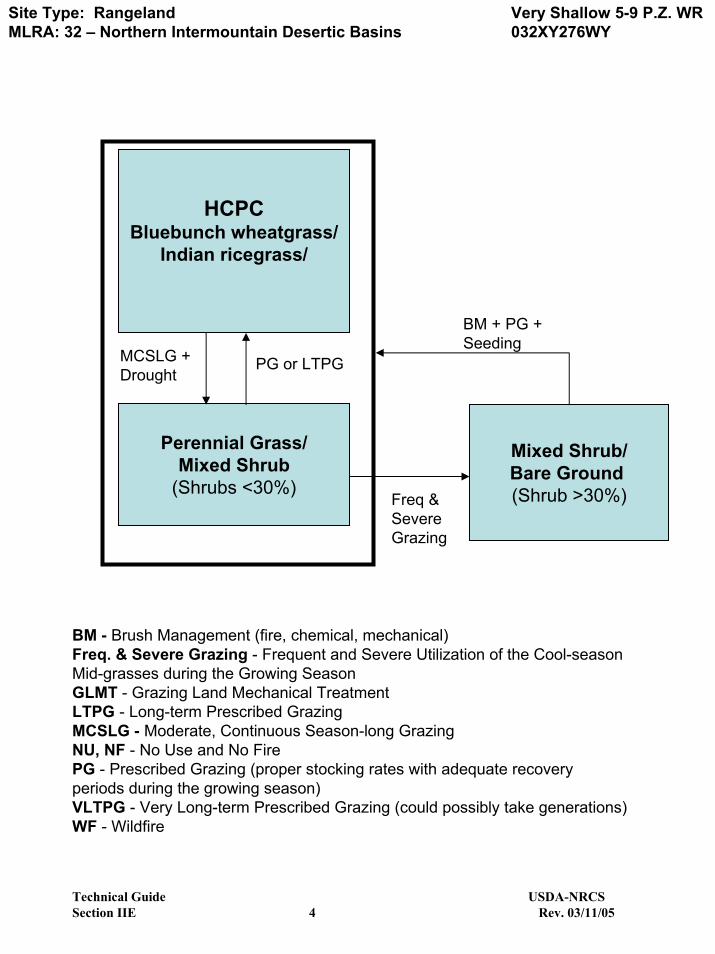
Plant Communities Ecological Dynamics of the Site: Potential vegetation on this site is dominated by a variety of mid cool-season perennial grasses. Other significant vegetation includes winterfat and a variety of forbs and shrubs. The expected potential composition for this site is about 65% grasses, 15% forbs and 20% woody plants. The composition and production will vary naturally due to historical use, fluctuating precipitation and fire frequency. As this site deteriorates, species such as short warm-season grasses, badlands mules-ear, and shrubs will increase. Weedy annuals will invade. Cool season grasses such as bluebunch wheatgrass and Indian ricegrass will decrease in frequency and production. The Historic Climax Plant Community (description follows the plant community diagram) has been determined by study of rangeland relic areas, or areas protected from excessive disturbance. Trends in plant communities going from heavily grazed areas to lightly grazed areas, seasonal use pastures, and historical accounts have also been used. The following is a State and Transition Model Diagram that illustrates the common plant communities (states) that can occur on the site and the transitions between these communities. The ecological processes will be discussed in more detail in the plant community narratives following the diagram.
Technical Guide USDA NRCS Section IIE 3 Rev. 03/11/05
Site Type: Rangeland MLRA: 32 – Northern Intermountain Desertic Basins
Very Shallow 5-9 P.Z. WR032XY276WY
HCPCBluebunch wheatgrass/
Indian ricegrass/
Perennial Grass/Mixed Shrub
(Shrubs <30%)
MCSLG + Drought
PG or LTPG
BM + PG + Seeding
Mixed Shrub/Bare Ground (Shrub >30%)Freq &
Severe Grazing
BM - Brush Management (fire, chemical, mechanical)Freq. & Severe Grazing - Frequent and Severe Utilization of the Cool-season Mid-grasses during the Growing SeasonGLMT - Grazing Land Mechanical TreatmentLTPG - Long-term Prescribed GrazingMCSLG - Moderate, Continuous Season-long GrazingNU, NF - No Use and No FirePG - Prescribed Grazing (proper stocking rates with adequate recovery periods during the growing season)VLTPG - Very Long-term Prescribed Grazing (could possibly take generations)WF - Wildfire
Technical Guide USDA-NRCSSection IIE 4 Rev. 03/11/05

Site Type: RangelandMLRA:32 - Northern Intermountain Desertic Basins
Very Shallow 5-9" WR P.Z.RO32XY276WY
GroupGRASSES AND GRASS-LIKES GRASSES/GRASSLIKESGriffiths wheatgrass or Elymus albicans ELAL7 1 26 - 53 15 - 30 Bluebunch wheatgrass Pseudoroegneria spicata PSSP6Western wheatgrass Pascopyrum smithii PASM 2 9 - 26 5 - 15Indian ricegrass Achnatherum hymenoides ACHY 3 9 - 35 5 - 20Needleandthread grass Hesperostipa comata HECO26 4 9 - 35 5 - 20 MISC. GRASSES/GRASSLIKES 5 9 - 35 5 - 20Blue grama Bouteloua gracilis BOGR2 5 0 - 9 0 - 5Bottlebrush squirreltail Elymus elymoides ELELE 5 0 - 9 0 - 5Fendler threeawn Aristida purpurea longiseta ARPUL 5 0 - 9 0 - 5Little bluestem Schizachyrium scoparium SCSC 5 0 - 9 0 - 5Prairie junegrass Koeleria macrantha KOMA 5 0 - 9 0 - 5Sand dropseed Sporobolus cryptandrus SPCR 5 0 - 9 0 - 5Sandberg bluegrass Poa secunda POSE 5 0 - 9 0 - 5Threadleaf sedge Carex filifolia CAFI 5 0 - 9 0 - 5other perennial grasses (native) 2GP 5 0 - 9 0 - 5FORBS 6 9 - 26 5 - 15Badlands mule's-ears Wyethia scabra WYSC 6 0 - 9 0 - 5Cutleaf daisy Erigeron compositus ERCO4 6 0 - 9 0 - 5Fleabane Erigeron spp. ERIGE2 6 0 - 9 0 - 5Franklin's sagewort Arenaria franklinii ARFR 6 0 - 9 0 - 5Fringed sagewort Artemisia frigida ARFR4 6 0 - 9 0 - 5Hood's phlox Phlox hoodii PHHO 6 0 - 9 0 - 5Miner's candle Cryptantha virgata CRVI4 6 0 - 9 0 - 5Missouri milkvetch Astragalus missouriensis ASMI10 6 0 - 9 0 - 5Nailwort Paronychia spp. PARON 6 0 - 9 0 - 5Sulphur flower buckwheat Eriogonum umbellatum ERUM 6 0 - 9 0 - 5Plains pricklypear cactus Opuntia polyacantha OPPO 6 0 - 9 0 - 5Scarlet globemallow Sphaeralcea coccinea SPCO 6 0 - 9 0 - 5Small-leaf pussytoes Antennaria parvifolia ANPA4 6 0 - 9 0 - 5Stemless mock goldenweed Stenotus acaulis STACA 6 0 - 9 0 - 5Tufted evening-primrose Oenothera caespitosa OECA10 6 0 - 9 0 - 5Wavyleaf paintbrush Castilleja applegatei martinii CAAPM 6 0 - 9 0 - 5Western yarrow Achillea lanulosa ACHIL 6 0 - 9 0 - 5Woollypod milkvetch Astragalus purshii ASPU9 6 0 - 9 0 - 5other perennial forbs (native) 2FP 6 0 - 9 0 - 5TREES/SHRUBS 7 18 - 44 10 - 25Green rabbitbrush Chrysothamnus viscidiflorus CHVI8 7 0 - 9 0 - 5Rubber rabbitbrush Ericameria nauseosa ERNA10 7 0 - 9 0 - 5Skunkbush sumac Rhus trilobata RHTR 7 0 - 9 0 - 5Soapweed yucca Yucca glauca YUGL 7 0 - 9 0 - 5Spiny gilia Leptodactylon pungens LEPU 7 0 - 9 0 - 5Utah juniper Juniperus osteosperma JUOS 7 0 - 9 0 - 5Winterfat Krascheninnikovia lanata KRAL2 7 0 - 9 0 - 5Wyoming big sagebrush Artemisia tridentata wyomingensis ARTRW8 7 0 - 9 0 - 5other shrubs & half shrubs (native) 2SHRUB 7 0 - 9 0 - 5
% Comp.
This list of plants and their relative proportions are based on near normal years. Fluctuations in species composition and relative production may change from year to year dependent upon precipitation or other climatic factors.
Plant Community Composition and Group Annual ProductionReference Plant Community (HCPC)
COMMON NAME/GROUP NAME SCIENTIFIC NAME SYMBOLAnnual Production (Normal Year)
Total: 175lbs./acre
Technical GuideSection IIE 5
USDA - NRCSRev. 03/11/05
Site Type: Rangeland Very Shallow (VS) 5-9 WR MLRA: 32 – Northern Intermountain Basins R032XY276WY
Plant Community Narratives Following are the narratives for each of the described plant communities. These plant communities may not represent every possibility, but they probably are the most prevalent and repeatable plant communities. The plant composition tables shown above have been developed from the best available knowledge at the time of this revision. As more data is collected, some of these plant communities may be revised or removed, and new ones may be added. None of these plant communities should necessarily be thought of as “Desired Plant Communities”. According to the USDA NRCS National Range and Pasture Handbook, Desired Plant Communities (DPC’s) will be determined by the decision-makers and will meet minimum quality criteria established by the NRCS. The main purpose for including any description of a plant community here is to capture the current knowledge and experience at the time of this revision. Bluebunch wheatgrass/Indian Ricegrass Plant Community The interpretive plant community for this site is the Historic Climax Plant Community. This state evolved with grazing by large herbivores and droughty soils due to the limited water holding capacity. This plant community can be found on areas that are properly managed with grazing and on areas receiving occasional short periods of rest. Potential vegetation is about 65% grasses or grass-like plants, 15% forbs, and 20% woody plants. Cool season midgrasses dominate the state. The major grasses include bluebunch wheatgrass, Indian ricegrass, needleandthread, and rhizomatous wheatgrasses. Other grasses and grass-likes occurring on the state include bottlebrush squirreltail, Sandberg bluegrass, Fendler threeawn, blue grama, and threadleaf sedge. Winterfat is a conspicuous element of this state and can make up 5% of the annual production. A variety of shrubs and forbs can be present and plant diversity is high (see Plant Composition Table). The total annual production (air-dry weight) of this state is about 175 pounds per acre, but it can range from about 75 lbs./acre in unfavorable years to about 250 lbs./acre in above average years. The following is the growth curve of this plant community expected during a normal year: Growth curve number: Growth curve name: Growth curve description:
JAN FEB MAR APR MAY JUN JUL AUG SEP OCT NOV DEC 0 0 0 10 50 25 5 0 10 0 0 0 (Monthly percentages of total annual growth)
The state is stable and well adapted to the Northern Great Plains climatic conditions. The diversity in plant species allows for high drought resistance. This is a sustainable plant community (site/soil stability, watershed function, and biologic integrity Transitions or pathways leading to other plant communities are as follows:
• Moderate Continuous Season-Long Grazing will convert this plant community to the Perennial Grass/Mixed Shrub Plant Community. Prolonged Drought will exacerbate this transition.
Perennial Grass/Mixed Shrub Plant Community Historically, this plant community evolved under grazing and a low fire frequency. Currently, it is found under moderate, season-long grazing by livestock and will be exacerbated by prolonged drought conditions. This plant community is still dominated by cool-season grasses, while short warm-season grasses and miscellaneous forbs account for the balance of the understory.
Technical Guide USDA NRCS Section IIE 6 Rev. 03/11/05
Site Type: Rangeland Very Shallow (VS) 5-9 WR MLRA: 32 – Northern Intermountain Basins R032XY276WY
A variety of shrubs make up the overstory. Dominant grasses include bluebunch wheatgrass, needleandthread, and rhizomatous wheatgrasses. Grasses and grass-likes of secondary importance include Sandberg bluegrass, blue grama, Fendler threeawn, and threadleaf sedge. Forbs commonly found in this plant community include badlands mules-ear, tufted evening primrose, stemless mock goldweed, Hood’s phlox, prairie sulfur flower buckwheat, and scarlet globemallow. A mixture of shrubs which include Wyoming big sagebrush, skunkbush sumac, green rabbitbrush, and yucca account for 20% to 30% of the total production. Rocky Mountain juniper and black sagebrush can be present but usually occur only at the upper end of the precipitation zone. Plains pricklypear can also occur. When compared to the Historical Climax Plant Community, Wyoming big sagebrush and skunkbush sumac have increased. Indian ricegrass and bluebunch wheatgrass have decreased as the production of cool-season grasses has been reduced. Indian ricegrass may occur in only trace amounts under the sagebrush canopy or within the patches of pricklypear. Blue grama and threadleaf sedge have increased. Plains pricklypear cactus will also have increased, but occurs only in small patches. In addition, the amount of winterfat may or may not have changed depending on the season of use. The total annual production (air-dry weight) of this state is about 110 pounds per acre, but it can range from about 50 lbs./acre in unfavorable years to about 200 lbs./acre in above average years. The following is the growth curve of this plant community expected during a normal year:
Growth curve number: Growth curve name: Growth curve description: JAN FEB MAR APR MAY JUN JUL AUG SEP OCT NOV DEC
0 0 0 10 50 25 5 0 10 0 0 0 (Monthly percentages of total annual growth)
This plant community is resistant to change. The herbaceous species present are well adapted to grazing; however, species composition can be altered through long-term overgrazing. The herbaceous component is mostly intact and plant vigor and replacement capabilities are sufficient. Water flow patterns and litter movement may be occurring but only on steeper slopes. Incidence of pedestalling is minimal. Soils are mostly stable and the surface shows minimum soil loss. The watershed is functioning and the biotic community is intact. Transitional pathways leading to other plant communities are as follows:
• Prescribed grazing or possibly long-term prescribed grazing, will convert this plant community to the HCPC. The probability of this occurring is high especially if rotational grazing along with short deferred grazing is implemented as part of a prescribed method of use. In addition, the removal of fire suppression will allow a somewhat natural fire regime to reoccur to more easily transition between this plant community and the HCPC. A prescribed fire treatment can be useful to hasten this transition, if desired. The wide gaps between plants, however, may create a problem in carrying a fire. A lengthy period of non use after a high precipitation year may be necessary in implementing this practice.
• Frequent and severe grazing over the long-term will convert this plant community to the Mixed
Shrub/Bare Ground vegetative state.
Technical Guide USDA NRCS Section IIE 7 Rev. 03/11/05
Site Type: Rangeland Very Shallow (VS) 5-9 WR MLRA: 32 – Northern Intermountain Basins R032XY276WY
Mixed Shrub/Bare Ground Plant Community This vegetation state currently is found under heavy, season-long grazing by. Wyoming big sagebrush, skunkbush sumac, green rabbitbrush and yucca are significant components of this plant community. Rocky Mountain juniper and black sagebrush can be present but usually occur only at the upper end of the precipitation zone. Cool-season grasses have been reduced. Bare ground, warm season grasses, and annual plants dominate the understory. The dominant grasses and grass-likes are threadleaf sedge and blue grama. Weedy annual species such as cheatgrass, and Russian thistle may occupy the site, if a seed source is available. Cactus and sageworts often increase. Noxious weeds such as Russian knapweed may invade the site if a seed source is available. The interspaces between plants have expanded significantly leaving the amount of bare ground more prevalent. As compared with the Perennial Grass/ Mixed Shrub Plant Community, the reduction in the annual production is not significant, as the shrub production off sets the decline in the herbaceous production. The total annual production (air-dry weight) of this state is about 75 pounds per acre, but it can range from about 25 lbs./acre in unfavorable years to about 200 lbs./acre in above average years. The following is the growth curve expected during a normal year:
Growth curve number: Growth curve name: Growth curve description: JAN FEB MAR APR MAY JUN JUL AUG SEP OCT NOV DEC
0 0 0 10 50 25 5 0 10 0 0 0 (Monthly percentages of total annual growth)
This plant community is resistant to change. Continued frequent and severe grazing or the removal of grazing does not seem to affect the composition or structure of the plant community. Plant diversity is moderate to poor. The plant vigor is diminished and replacement capabilities are limited due to the reduced number of cool-season grasses. Plant litter is noticeably less when compared to the HCPC. Soil erosion is accelerated because of increased bare ground. Water flow patterns and pedestalling are obvious. Infiltration is reduced and runoff is increased. Rill channels may be noticeable in the interspaces and gullies may be establishing where rills have concentrated down slope. Transitional pathways leading to other plant communities are as follows:
• Brush management and prescribed grazing will return this state to near Historic Climax Plant Community. Seeding native perennials may be necessary to hasten establishment of these species.
Ecological Site Interpretations Animal Community – Wildlife Interpretations
Historic Climax Plant Community: The predominance of grasses in this plant community favors grazers and mixed-feeders, such as bison, elk, and antelope. Suitable thermal and escape cover for deer may be limited due to the low quantities of woody plants. However, topographical variations could provide some escape cover. When found adjacent to sagebrush dominated states, this plant community may provide brood rearing/foraging areas for sage grouse, as well as lek sites. Other
Technical Guide USDA NRCS Section IIE 8 Rev. 03/11/05

Site Type: Rangeland Very Shallow (VS) 5-9 WR MLRA: 32 – Northern Intermountain Basins R032XY276WY
birds that would frequent this plant community include western meadowlarks, horned larks, and golden eagles. Many grassland obligate small mammals would occur here. Perennial Grass/Mixed Shrub: The combination of a shrub overstory and an understory of grasses and forbs provide a very diverse plant community for wildlife. This diversity provides important winter ranges, so mule deer and antelope may use this state for foraging year-round, as would cottontail and jack rabbits Mixed Shrub/Bare Ground: This plant community can provide winter foraging for mule deer and antelope, as brush can approach 15% protein and 40-60% digestibility during that time. Due to the sparseness of the vegetation, this community does not provide escape and thermal cover for large ungulates or for nesting habitat for sage grouse.
Technical Guide USDA NRCS Section IIE 9 Rev. 03/11/05
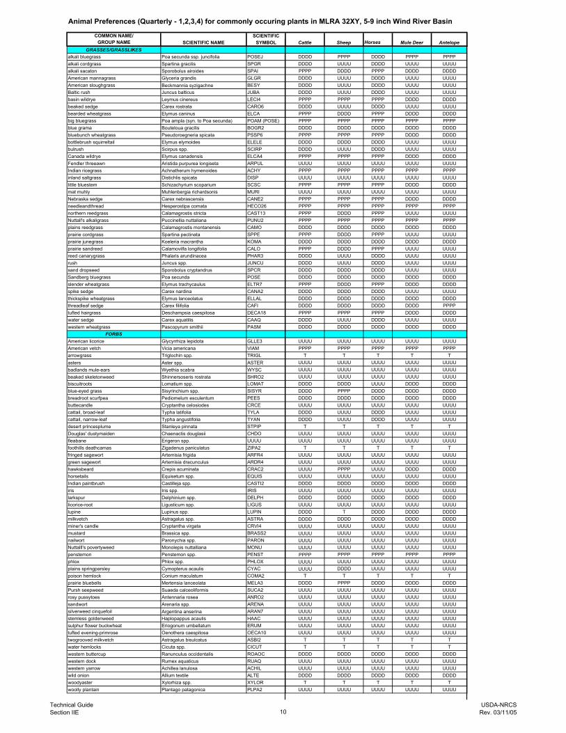
Animal Preferences (Quarterly - 1,2,3,4) for commonly occuring plants in MLRA 32XY, 5-9 inch Wind River Basin
COMMON NAME/ SCIENTIFICGROUP NAME SCIENTIFIC NAME SYMBOL Cattle Sheep Horses Mule Deer Antelope
GRASSES/GRASSLIKESalkali bluegrass Poa secunda ssp. juncifolia POSEJ DDDD PPPP DDDD PPPP PPPPalkali cordgrass Spartina gracilis SPGR DDDD UUUU DDDD UUUU UUUUalkali sacaton Sporobolus airoides SPAI PPPP DDDD PPPP DDDD DDDDAmerican mannagrass Glyceria grandis GLGR DDDD UUUU DDDD UUUU UUUUAmerican sloughgrass Beckmannia syzigachne BESY DDDD UUUU DDDD UUUU UUUUBaltic rush Juncus balticus JUBA DDDD UUUU DDDD UUUU UUUUbasin wildrye Leymus cinereus LECI4 PPPP PPPP PPPP DDDD DDDDbeaked sedge Carex rostrata CARO6 DDDD UUUU DDDD UUUU UUUUbearded wheatgrass Elymus caninus ELCA PPPP DDDD PPPP DDDD DDDDbig bluegrass Poa ampla (syn. to Poa secunda) POAM (POSE) PPPP PPPP PPPP PPPP PPPPblue grama Bouteloua gracilis BOGR2 DDDD DDDD DDDD DDDD DDDDbluebunch wheatgrass Pseudoroegneria spicata PSSP6 PPPP PPPP PPPP DDDD DDDDbottlebrush squirreltail Elymus elymoides ELELE DDDD DDDD DDDD UUUU UUUUbulrush Scirpus spp. SCIRP DDDD UUUU DDDD UUUU UUUUCanada wildrye Elymus canadensis ELCA4 PPPP PPPP PPPP DDDD DDDDFendler threeawn Aristida purpurea longiseta ARPUL UUUU UUUU UUUU UUUU UUUUIndian ricegrass Achnatherum hymenoides ACHY PPPP PPPP PPPP PPPP PPPPinland saltgrass Distichlis spicata DISP UUUU UUUU UUUU UUUU UUUUlittle bluestem Schizachyrium scoparium SCSC PPPP PPPP PPPP DDDD DDDDmat muhly Muhlenbergia richardsonis MURI UUUU UUUU UUUU UUUU UUUUNebraska sedge Carex nebrascensis CANE2 PPPP PPPP PPPP DDDD DDDDneedleandthread Hesperostipa comata HECO26 PPPP PPPP PPPP PPPP PPPPnorthern reedgrass Calamagrostis stricta CAST13 PPPP DDDD PPPP UUUU UUUUNuttall's alkaligrass Puccinellia nuttaliana PUNU2 PPPP PPPP PPPP PPPP PPPPplains reedgrass Calamagrostis montanensis CAMO DDDD DDDD DDDD DDDD DDDDprairie cordgrass Spartina pectinata SPPE PPPP DDDD PPPP UUUU UUUUprairie junegrass Koeleria macrantha KOMA DDDD DDDD DDDD DDDD DDDDprairie sandreed Calamovilfa longifolia CALO PPPP DDDD PPPP UUUU UUUUreed canarygrass Phalaris arundinacea PHAR3 DDDD UUUU DDDD UUUU UUUUrush Juncus spp. JUNCU DDDD UUUU DDDD UUUU UUUUsand dropseed Sporobolus cryptandrus SPCR DDDD DDDD DDDD UUUU UUUUSandberg bluegrass Poa secunda POSE DDDD DDDD DDDD DDDD DDDDslender wheatgrass Elymus trachycaulus ELTR7 PPPP DDDD PPPP DDDD DDDDspike sedge Carex nardina CANA2 DDDD DDDD DDDD UUUU UUUUthickspike wheatgrass Elymus lanceolatus ELLAL DDDD DDDD DDDD DDDD DDDDthreadleaf sedge Carex filifolia CAFI DDDD DDDD DDDD DDDD PPPPtufted hairgrass Deschampsia caespitosa DECA18 PPPP PPPP PPPP DDDD DDDDwater sedge Carex aquatilis CAAQ DDDD UUUU DDDD UUUU UUUUwestern wheatgrass Pascopyrum smithii PASM DDDD DDDD DDDD DDDD DDDD
FORBSAmerican licorice Glycyrrhiza lepidota GLLE3 UUUU UUUU UUUU UUUU UUUUAmerican vetch Vicia americana VIAM PPPP PPPP PPPP PPPP PPPParrowgrass Triglochin spp. TRIGL T T T T Tasters Aster spp. ASTER UUUU UUUU UUUU UUUU UUUUbadlands mule-ears Wyethia scabra WYSC UUUU UUUU UUUU UUUU UUUUbeaked skeletonweed Shinnersoseris rostrata SHRO2 UUUU UUUU UUUU UUUU UUUUbiscuitroots Lomatium spp. LOMAT DDDD DDDD UUUU DDDD DDDDblue-eyed grass Sisyrinchium spp. SISYR DDDD PPPP DDDD DDDD DDDDbreadroot scurfpea Pediomelum esculentum PEES DDDD DDDD DDDD DDDD DDDDbuttecandle Cryptantha celosiodes CRCE UUUU UUUU UUUU UUUU UUUUcattail, broad-leaf Typha latifolia TYLA DDDD UUUU DDDD UUUU UUUUcattail, narrow-leaf Typha angustifolia TYAN DDDD UUUU DDDD UUUU UUUUdesert princesplume Stanleya pinnata STPIP T T T T TDouglas' dustymaiden Chaenactis douglasii CHDO UUUU UUUU UUUU UUUU UUUUfleabane Erigeron spp. UUUU UUUU UUUU UUUU UUUU UUUUfoothills deathcamas Zigadenus paniculatus ZIPA2 T T T T Tfringed sagewort Artemisia frigida ARFR4 UUUU UUUU UUUU UUUU UUUUgreen sagewort Artemisia dracunculus ARDR4 UUUU UUUU UUUU UUUU UUUUhawksbeard Crepis acuminata CRAC2 UUUU PPPP UUUU DDDD DDDDhorsetails Equisetum spp. EQUIS UUUU UUUU UUUU UUUU UUUUIndian paintbrush Castilleja spp. CASTI2 DDDD DDDD DDDD DDDD DDDDiris Iris spp. IRIS UUUU UUUU UUUU UUUU UUUUlarkspur Delphinium spp. DELPH DDDD DDDD DDDD DDDD DDDDlicorice-root Ligusticum spp. LIGUS UUUU UUUU UUUU UUUU UUUUlupine Lupinus spp. LUPIN DDDD T DDDD DDDD DDDDmilkvetch Astragalus spp. ASTRA DDDD DDDD DDDD DDDD DDDDminer's candle Cryptantha virgata CRVI4 UUUU UUUU UUUU UUUU UUUUmustard Brassica spp. BRASS2 UUUU UUUU UUUU UUUU UUUUnailwort Paronychia spp. PARON UUUU UUUU UUUU UUUU UUUUNuttalll's povertyweed Monolepis nuttalliana MONU UUUU UUUU UUUU UUUU UUUUpenstemon Penstemon spp. PENST PPPP PPPP PPPP PPPP PPPPphlox Phlox spp. PHLOX UUUU UUUU UUUU UUUU UUUUplains springparsley Cymopterus acaulis CYAC UUUU DDDD UUUU UUUU UUUUpoison hemlock Conium maculatum COMA2 T T T T Tprairie bluebells Mertensia lanceolata MELA3 DDDD PPPP DDDD DDDD DDDDPursh seepweed Suaeda calceoliformis SUCA2 UUUU UUUU UUUU UUUU UUUUrosy pussytoes Antennaria rosea ANRO2 UUUU UUUU UUUU UUUU UUUUsandwort Arenaria spp. ARENA UUUU UUUU UUUU UUUU UUUUsilverweed cinquefoil Argentina anserina ARAN7 UUUU UUUU UUUU UUUU UUUUstemless goldenweed Haplopappus acaulis HAAC UUUU UUUU UUUU UUUU UUUUsulphur flower buckwheat Eriogonum umbellatum ERUM UUUU UUUU UUUU UUUU UUUUtufted evening-primrose Oenothera caespitosa OECA10 UUUU UUUU UUUU UUUU UUUUtwogrooved milkvetch Astragalus bisulcatus ASBI2 T T T T Twater hemlocks Cicuta spp. CICUT T T T T Twestern buttercup Ranunculus occidentalis ROAOC DDDD DDDD DDDD DDDD DDDDwestern dock Rumex aquaticus RUAQ UUUU UUUU UUUU UUUU UUUUwestern yarrow Achillea lanulosa ACHIL UUUU UUUU UUUU UUUU UUUUwild onion Allium textile ALTE DDDD DDDD DDDD DDDD DDDDwoodyaster Xylorhiza spp. XYLOR T T T T Twoolly plantain Plantago patagonica PLPA2 UUUU UUUU UUUU UUUU UUUU
Technical GuideSection IIE 10
USDA-NRCSRev. 03/11/05
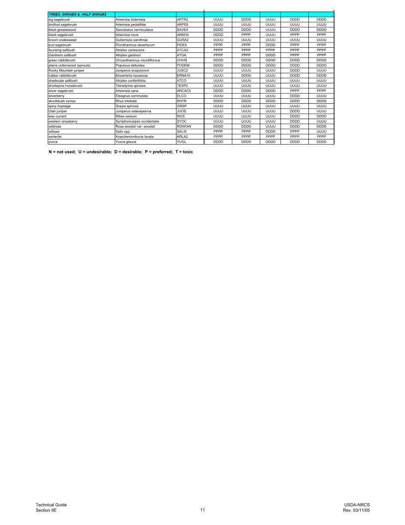
TREES, SHRUBS & HALF-SHRUBSbig sagebrush Artemisia tridentata ARTR2 UUUU DDDD UUUU DDDD DDDDbirdfoot sagebrush Artemisia pedatifida ARPE6 UUUU UUUU UUUU UUUU UUUUblack greasewood Sarcobatus vermiculatus SAVE4 DDDD DDDD UUUU DDDD DDDDblack sagebrush Artemisia nova ARNO4 DDDD PPPP UUUU PPPP PPPPbroom snakeweed Gutierrezia sarothrae GUSA2 UUUU UUUU UUUU UUUU UUUUbud sagebrush Picrothamnus desertorum PIDE4 PPPP PPPP DDDD PPPP PPPPfourwing saltbush Atriplex canescens ATCA2 PPPP PPPP PPPP PPPP PPPPGardners saltbush Atriplex gardneri ATGA PPPP PPPP DDDD PPPP PPPPgreen rabbitbrush Chrysothamnus viscidiflorous CHVI8 DDDD DDDD DDDD DDDD DDDDplains cottonwood (sprouts) Populous deltoides PODEM DDDD DDDD DDDD DDDD DDDDRocky Mountain juniper Juniperus scopulorum JUSC2 UUUU UUUU UUUU DDDD UUUUrubber rabbitbrush Ericameria nauseosa ERNA10 UUUU DDDD UUUU DDDD DDDDshadscale saltbush Atriplex confertifolia ATCO UUUU UUUU UUUU UUUU UUUUshortspine horsebrush Tetradymia spinosa TESP2 UUUU UUUU UUUU UUUU UUUUsilver sagebrush Artemisia cana ARCAC5 DDDD DDDD DDDD PPPP PPPPsilverberry Eleagnus commutata ELCO UUUU UUUU UUUU DDDD UUUUskunkbush sumac Rhus trilobata RHTR DDDD DDDD DDDD DDDD DDDDspiny hopsage Grayia spinosa GRSP UUUU UUUU UUUU UUUU UUUUUtah juniper Juniperus osteosperma JUOS UUUU UUUU UUUU DDDD UUUUwax currant Ribes cereum RICE UUUU UUUU UUUU DDDD DDDDwestern snowberry Symphoricarpos occidentalis SYOC UUUU UUUU UUUU DDDD UUUUwildrose Rosa woodsii var. woodsii ROWOW DDDD DDDD UUUU DDDD DDDDwillows Salix spp. SALIX PPPP PPPP DDDD PPPP UUUUwinterfat Krascheninnikovia lanata KRLA2 PPPP PPPP PPPP PPPP PPPPyucca Yucca glauca YUGL DDDD DDDD DDDD DDDD DDDD
N = not used; U = undesirable; D = desirable; P = preferred; T = toxic
Technical GuideSection IIE 11
USDA-NRCSRev. 03/11/05
Site Type: Rangeland Very Shallow (VS) 5-9 WR MLRA: 32 – Northern Intermountain Basins R032XY276WY
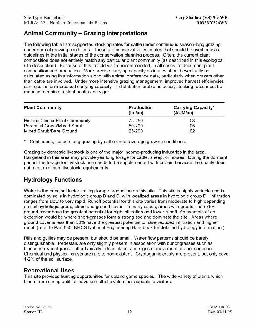
Animal Community – Grazing Interpretations The following table lists suggested stocking rates for cattle under continuous season-long grazing under normal growing conditions. These are conservative estimates that should be used only as guidelines in the initial stages of the conservation planning process. Often, the current plant composition does not entirely match any particular plant community (as described in this ecological site description). Because of this, a field visit is recommended, in all cases, to document plant composition and production. More precise carrying capacity estimates should eventually be calculated using this information along with animal preference data, particularly when grazers other than cattle are involved. Under more intensive grazing management, improved harvest efficiencies can result in an increased carrying capacity. If distribution problems occur, stocking rates must be reduced to maintain plant health and vigor. Plant Community Production Carrying Capacity* (lb./ac) (AUM/ac) Historic Climax Plant Community 75-250 .08 Perennial Grass/Mixed Shrub 50-200 .05 Mixed Shrub/Bare Ground 25-200 .02 * - Continuous, season-long grazing by cattle under average growing conditions. Grazing by domestic livestock is one of the major income-producing industries in the area. Rangeland in this area may provide yearlong forage for cattle, sheep, or horses. During the dormant period, the forage for livestock use needs to be supplemented with protein because the quality does not meet minimum livestock requirements. Hydrology Functions Water is the principal factor limiting forage production on this site. This site is highly variable and is dominated by soils in hydrologic group B and C, with localized areas in hydrologic group D. Infiltration ranges from slow to very rapid. Runoff potential for this site varies from moderate to high depending on soil hydrologic group, slope and ground cover. In many cases, areas with greater than 75% ground cover have the greatest potential for high infiltration and lower runoff. An example of an exception would be where short-grasses form a strong sod and dominate the site. Areas where ground cover is less than 50% have the greatest potential to have reduced infiltration and higher runoff (refer to Part 630, NRCS National Engineering Handbook for detailed hydrology information.) Rills and gullies may be present, but should be small. Water flow patterns should be barely distinguishable. Pedestals are only slightly present in association with bunchgrasses such as bluebunch wheatgrass. Litter typically falls in place, and signs of movement are not common. Chemical and physical crusts are rare to non-existent. Cryptogamic crusts are present, but only cover 1-2% of the soil surface. Recreational Uses This site provides hunting opportunities for upland game species. The wide variety of plants which bloom from spring until fall have an esthetic value that appeals to visitors.
Technical Guide USDA NRCS Section IIE 12 Rev. 03/11/05

Site Type: Rangeland Very Shallow (VS) 5-9 WR MLRA: 32 – Northern Intermountain Basins R032XY276WY
Technical Guide USDA NRCS Section IIE 13 Rev. 03/11/05
Wood Products No appreciable wood products are present on the site. Other Products None noted. Supporting Information Associated Sites
Shallow Sandy 032XY266WY Shallow Loamy 032XY262WY
Similar Sites
() – Very Shallow 10-14” Foothills and Basins East P.Z., 032X376WY has higher production than Very Shallow 5-9” WR.
Inventory Data References (narrative) Information presented here has been derived from NRCS inventory data. Field observations from range trained personnel were also used. Those involved in developing this site include: Chris Krassin, Range Management Specialist, NRCS and Everet Bainter, Range Management Specialist, NRCS. Other sources used as references include USDA NRCS Water and Climate Center, USDA NRCS National Range and Pasture Handbook, USDI and USDA Interpreting Indicators of Rangeland Health Version 3, and USDA NRCS Soil Surveys from various counties. Inventory Data References Ocular field estimations observed by trained personnel. State Correlation The site occurs entirely in Wyoming. Type Locality Field Offices Casper, Lander, Riverton, Dubious, Fort Washakie Relationship to Other Established Classifications Other References Site Description Approval _______________________________________________ _______________ State Range Management Specialist Date