united states map physical map: label the following: – appalachian mountains – gulf of...
TRANSCRIPT

United States Map• Physical Map: Label the following: – Appalachian Mountains– Gulf Of California– Rocky Mountains– Gulf of Mexico– Mt. McKinley– Great Basin– Great Lakes- Each one– Great Plains– Mississippi River– Coastal Plain– Colorado River– Rio Grande
• Political Map• Label all states
and color (using at least 5-6 colors)

North AmericaPhysical Features

Landform Regions• United States and Canada make up 80% of the continent• Major landform regions of the United States and Canada
generally stretch from North to South– Eastern Coastal plain– Piedmont (area at or near foot of a mountain region)– Appalachian Mountains– Canadian Shield– Rocky Mountains– Pacific Coast Region


Dividing Up America!!Three main features
• Appalachian Mountains were created by the collision of the North American plate with the African plate – Highest peak in the Appalachian Mts.- 6,000 feet
• Interior Plains– Mississippi River and its tributaries drain this region– Includes the Great Lakes-formed by glaciers
• Rocky Mountains-From New Mexico to Canada – Some of the highest peaks reach 14,000!
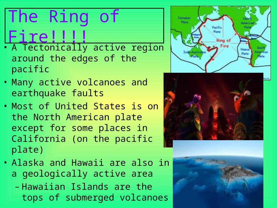
The Ring of Fire!!!!• A Tectonically active region around
the edges of the pacific• Many active volcanoes and
earthquake faults• Most of United States is on the
North American plate except for some places in California (on the pacific plate)
• Alaska and Hawaii are also in a geologically active area– Hawaiian Islands are the tops of
submerged volcanoes

Bodies of Water
• Continental Divide-Created by the Rockies, divides rivers flowing east and west
• Major River Systems– Mississippi, Missouri, Ohio (Flow
East)– St. Lawrence System– Western Rivers- Colorado,
Columbia, Yukon (Flow West)
• Major Lakes– Great Lakes in US– Great Bear and Great Slave in
Canada

Climates• Tropical Wet and Dry- Southern tip of Florida and parts of Hawaii• Humid Subtropical- Most of Southeastern US• Humid Continental- Northeast US and Southern and SE Canada• Semi-Arid-Great Plains, parts of MT. regions• Highland- Rocky mountains• Marine West Coast- Southeast Alaska and Northern California• Mediterranean- South and Central California• Tropical Humid- Parts of Hawaii• Tundra- Far North America• Subarctic- Most of Canada and Alaska


Natural Resources
• Farming- – Variety of soils and climates– Abundant crops and livestock
• Forests-– Leading producers of wood and paper
• Water- – Plentiful supplies– Irrigation and Hydroelectric power

Resources of the United States
• US is the world’s leading agricultural producer• Only about 3% of the population farms– But we still feed our people and have enough to
export!!!
• Great Plains region- great for corn, soybeans, and wheat
• The US has 25% of the world’s coal reserves and is a major coal exporter– Appalachians, Rockies, and Interior Plains

• US is a major oil producer but uses more than it produces– Gulf Coast, California, and Alaska
• We have valuable mineral resources: – Iron, copper, lead, zinc, gold, and silver