united states roadway safety data capabilities assessment
TRANSCRIPT
http://safety.fhwa.dot.gov
FHWA Safety Program
United States Roadway Safety Data Capabilities Assessment

STATE DATA CAPABILITIES ASSESSMENT FINAL REPORT
i
FOREWORD
The Federal Highway Administration (FHWA) conducted a capabilities assessment for each State in
terms of the collection, management, and use of roadway safety data. This project is part of the
Roadway Safety Data Partnership (RSDP), a collaborative effort between the FHWA and States to
ensure that they are best able to develop robust data-driven safety capabilities. This final report provides
an overview of findings based upon the assessment of fifty States plus the District of Columbia and
Puerto Rico.
Notice
This document is disseminated under the sponsorship of the U.S. Department of
Transportation in the interest of information exchange. The U.S. Government assumes no
liability for the use of the information contained in this document.
The U.S. Government does not endorse products or manufacturers. Trademarks or
manufacturers’ names appear in this report only because they are considered essential to the
objective of the document.
Quality Assurance Statement
The Federal Highway Administration (FHWA) provides high-quality information to serve
Government, industry, and the public in a manner that promotes public understanding.
Standards and policies are used to ensure and maximize the quality, objectivity, utility, and
integrity of its information. FHWA periodically reviews quality issues and adjusts its programs
and processes to ensure continuous quality improvement.

STATE DATA CAPABILITIES ASSESSMENT FINAL REPORT
ii
TECHNICAL DOCUMENTATION PAGE
1. Report No. FHWA-SA-12-028
2. Government Accession No.
3. Recipient's Catalog No.
4. Title and Subtitle United States Roadway Safety Data Capabilities Assessment
5. Report Date July 31, 2012
6. Performing Organization Code
7.Author(s) Michael Sawyer, Nancy Lefler, Jon Soika, Daniel Carter, Robert Scopatz, Frank Gross, Heather Rothenberg, Jeffrey Miller, Geni Bahar, Kim Eccles
8. Performing Organization Report No.
9. Performing Organization Name and Address Vanasse Hangen Brustlin, Inc (VHB) 8300 Boone Blvd., Suite 700 Vienna, VA 22182-2626
10. Work Unit No.
11. Contract or Grant No. DTFH61-05-D-00024 (VHB)
12. Sponsoring Agency Name and Address Federal Highway Administration Office of Safety 1200 New Jersey Ave., SE Washington, DC 20590
13. Type of Report and Period Final Report, Feb 2011 – July 2012
14. Sponsoring Agency Code FHWA
15. Supplementary Notes The contract manager for this project was Heather Rothenberg with support from Jeffrey Miller.
16. Abstract The Federal Highway Administration (FHWA) conducted a capabilities assessment for each State in terms of the collection, management, and use of roadway safety data. This project is part of the Roadway Safety Data Partnership (RSDP), a collaborative effort between the FHWA and States to ensure that they are best able to develop robust data-driven safety capabilities. This final report provides an overview of findings based upon the assessment of fifty States plus the District of Columbia and Puerto Rico.
17. Key Words: Roadway safety data, data collection, data management, data analysis, capability assessment, roadway inventory
18. Distribution Statement No restrictions.
19. Security Classif. (of this report) Unclassified
20. Security Classif. (of this page) Unclassified
21. No. of Pages 57
22. Price
Form DOT F 1700.7 (8-72) Reproduction of completed pages authorized

STATE DATA CAPABILITIES ASSESSMENT FINAL REPORT
iii

STATE DATA CAPABILITIES ASSESSMENT FINAL REPORT
iv
TABLE OF CONTENTS
INTRODUCTION ....................................................................................... 1
OBJECTIVE .................................................................................................. 7
METHODOLOGY ....................................................................................... 9
CAPABILITY MATURITY MODEL ............................................................................ 9
Area 1: Roadway Inventory Data Collection/Technical Standards ..................... 10
Area 2: Data Analysis Tools and Uses .................................................................... 11
Area 3: Data Management ...................................................................................... 12
Area 4: Data Interoperability and Expandability .................................................. 13
THE PILOT PHASE .................................................................................................... 13
THE PRE-ASSESSMENT PROCESS ......................................................................... 16
THE ASSESSMENT DAY ........................................................................................... 17
THE POST-ASSESSMENT PROCESS ..................................................................... 18
NEXT STEPS ............................................................................................................... 21
WEIGHTING ASSESSMENT ELEMENTS AND AREAS ....................................... 21
The Weight Scale for Assessment Elements......................................................... 21
Discussion of Element Weights ............................................................................... 22
WEIGHTED ELEMENT RESULTS ........................................................................... 25
WEIGHTED AREA RESULTS ................................................................................... 26
FINDINGS .................................................................................................. 28
FINDINGS ABOUT THE OVERALL ASSESSMENT PROCESS .......................... 28
GENERAL ASSESSMENT FINDINGS...................................................................... 28
KEY FINDINGS FOR AREA 1: DATA COLLECTION ........................................... 30
KEY FINDINGS FOR AREA 2: DATA ANALYSIS ................................................. 31
KEY FINDINGS FOR AREA 3: DATA MANAGEMENT ........................................ 33
KEY FINDINGS FOR AREA 4: DATA INTEROPERABILITY ............................... 34
NATIONAL GAPS SUMMARY ................................................................................. 35
CONCLUSION .......................................................................................... 37

STATE DATA CAPABILITIES ASSESSMENT FINAL REPORT
vi
List of Tables
Table 1. Weighted Point System to Rate Each Element ............................................ 21
Table 2. Weighted Element Results .............................................................................. 26
Table 3. Maturity Level Results ...................................................................................... 48
List of Figures
Figure 1. Data Collection Elements............................................................................... 11
Figure 2. Data Analysis Elements .................................................................................. 12
Figure 3. Data Management Elements .......................................................................... 12
Figure 4. Data Interoperability Elements ..................................................................... 13
Figure 5. Element Capability Levels are weighted to form basis for Area Capability
Levels ................................................................................................................................ 27
Figure 6. Area Capability Levels form basis for Overall State Data Capability ....... 27
Figure 7. National Average Baseline for Stat Data Capability ................................... 36
Figure 8. Capability Maturity Level Distribution for Data Collection: Coverage .... 39
Figure 9. Capability Maturity Level Distribution for Data Collection: Timeliness .. 39
Figure 10. Capability Maturity Level for Data Collection: Accuracy ......................... 40
Figure 11. Capability Maturity Level Distribution for Data Collection:
Uniformity/Consistency .................................................................................................. 40
Figure 12. Capability Maturity Level Distribution for Data Analysis: Network
Screening (Data) .............................................................................................................. 41
Figure 13. Capability Maturity Level Distribution for Data Analysis: Network
Screening (Methodology) ................................................................................................ 41
Figure 14. Capability Maturity Level Distribution for Data Analysis: Network
Screening (Coverage) ...................................................................................................... 42
Figure 15. Capability Maturity Level Distribution for Data Analysis: Diagnosis ...... 42

STATE DATA CAPABILITIES ASSESSMENT FINAL REPORT
vii
Figure 16. Capability Maturity Level Distribution for Data Analysis:
Countermeasure Selection ............................................................................................. 43
Figure 17. Capability Maturity Level Distribution for Data Analysis: Evaluation..... 43
Figure 18. Capability Maturity Level Distribution for Data Analysis: Accessibility . 44
Figure 19. Capability Maturity Level Distribution for Data Management: People .. 44
Figure 20. Capability Maturity Level Distribution for Data Management: Policies . 45
Figure 21. Capability Maturity Level Distribution for Data Management:
Technology ....................................................................................................................... 45
Figure 22. Capability Maturity Level Distribution for Data Interoperability:
Interoperability ................................................................................................................ 46
Figure 23. Capability Maturity Level Distribution for Data Interoperability:
Expandability .................................................................................................................... 46
Figure 24. Capability Maturity Level Distribution for Data Interoperability: Linkage
........................................................................................................................................... 47

STATE DATA CAPABILITIES ASSESSMENT FINAL REPORT
viii
ACRONYMS
DOT Department of Transportation
CDIP Crash Data Improvement Program
COTM Contracting Officer’s Task Manager
CMM Capability Maturity Model
CMF Crash Modification Factor
EMS Emergency Medical Service
FDE Fundamental Data Elements
FMCSA Federal Motor Carrier Safety Administration
FHWA Federal Highway Administration
GAO Government Accountability Office
GIS Geographic Information System
GHSO Governor’s Highway Safety Office
HPMS Highway Performance Monitoring System
HSIP Highway Safety Improvement Program
HSIS Highway Safety Information System
HSM Highway Safety Manual
IHSDM Interactive Highway Safety Design Model
IT Information Technology
LIDAR Light Detection and Ranging
MIRE Model Inventory of Roadway Elements
MIRE-MIS Model Inventory of Roadway Elements Management Information System
MPO Metropolitan Planning Organization
NHTSA National Highway Traffic Safety Administration
NRSAP National Roadway Safety Data Action Plan
RDIP Roadway Data Improvement Program
RITA Research and Innovative Technology Administration
RSDP Roadway Safety Data Partnership
SAFETEA-LU Safe, Accountable, Flexible, Efficient Transportation Equity Act: Legacy for Users
SHSP Strategic Highway Safety Plan
SPF Safety Performance Function
TRA Traffic Record Assessment
TRCC Traffic Records Coordinating Committee
TWG Technical Working Group
USDOT United States Department of Transportation
STATE DATA CAPABILITIES ASSESSMENT FINAL REPORT
ix
PROJECT TEAM
Federal Highway Administration Office of Safety – Integration
1200 New Jersey Avenue, SE
Washington, D.C. 20590
Key FHWA Contacts
Heather Rothenberg
Contracting Officer’s Task Manager (COTM)
(202) 366-2193
Elease Sanders
Contract Specialist
Office of Acquisition Management
(202) 366-4201
In conjunction with:
Vanasse Hangen Brustlin, Inc. (VHB)
University of North Carolina Highway Safety Research Center (UNC-HSRC)
Data Nexus, Inc. (DNI)
Geni Bahar, P.E., NAVIGATS, Inc.
Dr. Forrest Council

STATE DATA CAPABILITIES ASSESSMENT FINAL REPORT
x
SAFETY DATA CAPABILITIES ASSESSMENT TEAM
VHB Team Management
Dr. Hugh McGee, Ph.D., Program Manager [email protected]
Ms. Kim Eccles, Technical Director [email protected]
Mr. Mike Sawyer, Principal Investigator [email protected]
Ms. Nancy Lefler, Project Manager [email protected]
Advisory Technical Experts
Dr. Forrest Council [email protected]
Ms. Barb Delucia (DNI) [email protected]
Ms. Geni Bahar (NAVIGATS, Inc.) [email protected]
Communications and Outreach
Mr. Eric Vierra (VHB) [email protected]
Mr. Michael Daul (UNC-HSRC) [email protected]
Ms. Katy Jones (UNC-HSRC) [email protected]
Lead State Assessors
Dr. Frank Gross (VHB) [email protected]
Dr. Robert Scopatz (DNI) [email protected]
Mr. Daniel Carter (UNC-HSRC) [email protected]
Mr. Jon Soika (VHB) [email protected]
Ms. Nancy Lefler (VHB) [email protected]
Technical Specialists
Mr. Carl Sundstrom (UNC-HSRC) [email protected]
Ms. Sarah Smith (UNC-HSRC) [email protected]
Ms. Becky Fiedler (VHB) [email protected]

STATE DATA CAPABILITIES ASSESSMENT FINAL REPORT
xi
ACKNOWLEDGEMENTS
The project team would like to thank all of the participating States and their leaders who are
actively working to improve their roadway safety data. The information collected through this
assessment process and the resulting improvements in data capabilities would not be possible
without these key leaders.
EXECUTIVE SUMMARY
The Federal Highway Administration (FHWA) conducted a capabilities assessment for each
State, the District of Columbia, and Puerto Rico on the collection, management, and use of
roadway safety data. This effort was part of the Roadway Safety Data Program (RSDP). The
RSDP is a collaborative effort between FHWA and States to develop robust, data-driven safety
capabilities. RSDP includes a variety of projects aimed at improving the collection, analysis,
management, and expansion of roadway data for use in safety programs and decision-making.
The purpose of this project was to develop, pilot, and conduct a consistent and thorough
roadway safety data capabilities assessment and to gain insight from the States to develop a
National Roadway Safety Data Action Plan (NRSDAP). The three primary objectives of this
project were:
To develop and carry out a consistent, repeatable, and systematic process to assess
State’s roadway safety data capabilities.
To understand what States capability goals are, and to help them identify critical gaps
and potential solutions to achieve their data goals.
To set future research and programmatic goals to further the evolving state of practice
for data-driven highway safety planning.
The capability assessment process used a five-level capability maturity model to describe the
current capability of each State. The assessment focused on the following four areas in each
State:
Roadway Inventory Data Collection / Technical Standards - What roadway
inventory data are collected? How are they collected? What standards must they meet?
Data Analysis Tools and Uses - How does roadway safety data relate to analysis
process including tools such as HSM, IHSDM, Safety Analyst, etc.?

STATE DATA CAPABILITIES ASSESSMENT FINAL REPORT
xii
Data Management - What policies and procedures exist for collection, maintenance,
usage, and updating of roadway safety data?
Data Interoperability and Expandability - How does roadway inventory data relate
to other data including, but not limited to, crash data, citation data, etc.? Can the
existing data be expanded as new technologies and tools are developed in the future?
Each of the four areas is made up of several subareas called elements. For example, the
Roadway Inventory Data Collection/Technical Standards area is comprised of four elements:
Completeness, Timeliness, Accuracy, and Uniformity/Consistency.
The project team used questionnaires and interviews to identify the current capability of each
State in the four areas. The States were active participants in this process. Each State
confirmed their current capability level and selected their desired capability level. For example,
a State that is currently a level 2 in Data Management might desire to become a level 4. The
identification of both current and desired levels will allow FHWA to better support State
roadway safety data improvement efforts.
This final report provides an overview of findings based upon the assessments, which were
conducted between May 2011 and May 2012. The project team averaged the findings of each
State to identify national gaps in capability. Consistent gaps from a national perspective center
on data management policies and technology, the completeness of the roadway inventory, and
countermeasure selection.
Overall, the Data Management area is the least understood. The average capability in this area
is 2.8 on the five-point scale, where five is the highest capability level. A bridge is needed
between IT professionals and safety engineers such that IT policies and technology can better
serve decision makers to fund the best safety improvements. The knowledge, skills, and
abilities of involved stakeholders are critical to improving and sustaining safety data capability.
Removing institutional barriers and having high functioning TRCCs and management boards are
important for sustained data capability. Case studies, best practices, and pilots are needed to
support how to best to overcome institutional barriers related to data management.
In the Roadway Inventory Data Collection area, the capability for one element, Completeness, is
consistently low across the States. The national average in the Completeness element is 2.6 on
the five-point scale. Many States attributed this lower capability to a lack of complete roadway
inventories on locally maintained roadways and fewer roadway inventory elements collected.
Resources need to be identified to support the collection of the Fundamental Data Elements
(FDE). FDEs are a basic set of elements that an agency would need to conduct enhanced safety
analyses regardless of the specific analysis tools used or methods applied. Appropriate
resources are also needed to keep the data collection efforts timely and reliable, particularly
when it comes to the FDEs.
STATE DATA CAPABILITIES ASSESSMENT FINAL REPORT
xiii
In the Data Analysis Tools and Uses area, the capability for the Countermeasure Selection
element is consistently low for the States, nationally averaging a 2.8 on the five-point scale.
Specifically in this area, States need better data in a readily accessible form to support safety
analyses. This would include detailed data elements describing safety-related infrastructure
attributes of the roadway and peripheral database information such as signs, lighting, pavement
condition and markings, etc. Proving the benefits of linking roadway inventory data to citation,
injury, and other non-traditional datasets would also provide a better understanding for States
to pursue more advanced roadway inventory centered analysis.
The findings of this effort present not only the current capabilities of the States through a
consistent and thorough assessment process; but, also provide insight on the States’ desired
capabilities and the actions needed to move the Nation forward in roadway safety data. These
findings and their associated actions will be confirmed through a series of peer exchanges
before inclusion in the National Roadway Safety Data Action Plan.

STATE DATA CAPABILITIES ASSESSMENT FINAL REPORT
1
INTRODUCTION
Highway safety analysis is evolving, and the importance of quality data has never been more
apparent. Quality safety data are the foundation for highway safety decisions. Much of the
effort in the safety community in previous years has concentrated on crash data; however,
crash data are only part of the picture. Roadway and traffic data are also essential. By
incorporating roadway and traffic data into their network screening, prioritization, and
countermeasure selection analysis, agencies can better identify safety problems and prescribe
solutions to improve safety and make more efficient and effective use of their safety funds.
Crash data alone are useful, but leave safety practitioners with purely reactive approaches—
identifying the locations where crashes have already happened. With the addition of traffic
volume data it is possible to develop estimates of the expected crash frequency and compare
crash rates for roadways with vastly different levels of service. As detailed roadway inventory
information is added to the mix, safety practitioners can now develop a more in-depth
understanding of the roadway attributes that contribute to crash risk thus allowing them to
adopt a proactive approach seeking out those factors associated with a high risk of crashes and
addressing sites that share those features in common.
FHWA developed the Roadway Safety Data Program (RSDP) as a collaborative effort between
FHWA and States to ensure that they are best able to develop robust data-driven safety
capabilities. RSDP includes a variety of projects all aimed at improving the collection, analysis,
management, and expansion of roadway data for use in safety programs and decision-making.
This report provides the highlights, methodology, and lessons learned from the assessments of
each State in terms of the collection, management, and use of roadway safety data. This
assessment, combined with a series of state peer exchanges, will denote national gaps and
provide FHWA with the information necessary to develop a National Roadway Safety Data
Action Plan.
BACKGROUND
The RSDP is meant to be an overarching framework that provides a foundation for roadway
safety data improvement efforts. This framework will establish a set of roadway safety data
improvement efforts that is cohesive, well-informed, and visionary enough to serve not only as
the basis for near-term improvements but also anticipate and plan for mid- and longer-term
projects.
A mature data-driven safety program requires that reliable crash data and roadway inventory
data be combined to provide a capability for systematic identification of infrastructure safety
improvement needs and many other aspects such as evaluation of safety and operational

STATE DATA CAPABILITIES ASSESSMENT FINAL REPORT
2
treatments, etc. State crash data systems have evolved to a point where there are standards for
crash data collection and tools available to help States assess the strengths and weaknesses of
their crash data systems. Roadway inventory data, however, has not been as thoroughly or
uniformly documented or assessed. The RSDP will contribute to the evolution of more robust
roadway safety data systems in each State by helping States identify gaps in their own programs.
The information gathered in the assessment will also provide an understanding of the national
opportunities and challenges related to roadway safety data systems and capabilities.
The RSDP is one element of a larger Department of Transportation effort to improve six
critical highway safety datasets: crash, driver, vehicle, roadway, EMS, citation/adjudication. RSDP
Technical Working Groups (TWGs) include representation from across FHWA including
Operations, Asset Management, Policy, and Planning. Additionally, representatives from
National Highway Traffic Safety Administration (NHTSA) and Research and Innovative
Technology Administration (RITA) are involved. The RSDP is meant to be complementary to
other programs throughout FHWA and the Department of Transportation (DOT) rather than
duplicative.
The RSDP will also include initiatives and programs beyond this assessment project, such as
standardization, guides, and technical assistance. FHWA may add additional initiatives under the
umbrella of the RSDP as their need becomes evident.
The following sections summarize ongoing RSDP initiatives necessary to achieve robust
roadway safety data capability in the States and across the Nation.
Data Capabilities Peer Exchanges
Following completion of this assessment project, each State will be invited to participate in one
of four peer-to-peer (P2P) exchanges based on the results of their assessment. The intent of
these meetings is for participants to exchange ideas and provide information about current
practices, approaches, and techniques that can be directly applied or adapted to fill gaps at the
State and at the Federal level. The P2P exchanges will assist participants in strengthening their
safety data action plans, leadership plans, and strategies. Finally, a National Roadway Safety
Data Action Plan (NRSDAP) will be developed based upon the outcomes of the P2P exchanges
and the findings in this report.
Each P2P exchange will have differences in composition and theme. The needs and areas of
interest identified by the participating States will determine the peer exchange topics. FHWA
will invite experts and States that have particular strengths and needs within each area. All four
peer exchanges will touch on the best practices, approaches, and techniques in the following
areas:

STATE DATA CAPABILITIES ASSESSMENT FINAL REPORT
3
Data Collection,
Data Analysis,
Data Management, and
Data Interoperability
National Roadway Safety Data Action Plan (NRSDAP)
Based on the national gap analysis developed during the State capability assessments and
information gathered during the P2P exchanges, FHWA will develop a NRSDAP. The NRSDAP
will be similar in concept to the State Safety Data Action Plans, which assist States to better
identify their goals and how to reach them. The NRSDAP will identify opportunities for
FHWA, and safety stakeholders, to provide national leadership and support to the States. The
NRSDAP will serve as a map for FHWA to move forward in its efforts to assist the States in
improving the quality of roadway safety data they use to support decision-making and program
implementation. This effort also seeks to further the evaluation of the state of practice for data-
driven safety decision-making.
FHWA aims to expand its relationship with the States by developing a better understanding of
the current capabilities and conditions of roadway inventory data collection in all States. The
NRSDAP is the capstone for the capabilities assessment. NRSDAP will achieve two major
objectives for FHWA and its State partners:
Create a mechanism by which FHWA will complete both national and State-specific gap
analyses, so that resources can be appropriately steered towards the greatest needs;
and
Provide tools, action planning guidance, and technical assistance to help States develop
action plans that will aim to overcome their gaps while integrating their data
improvement activities into their overall safety plans.
Model Inventory of Roadway Elements (MIRE)
The MIRE is a data dictionary that provides a listing of roadway and traffic elements that are
recommended for collection. It expands upon the elements required by the Highway
Performance Highway System (HPMS). The MIRE dictionary provides a definition for each
recommended element, a list of attributes for coding and a priority status rating of "critical" or
"value added", based on the elements' importance for use in analytic tools, such as the Safety
Analyst tool. Fundamental Data Elements (FDE) are a basic set of elements within MIRE that an
agency would need to conduct enhanced safety analyses regardless of the specific analysis tools

STATE DATA CAPABILITIES ASSESSMENT FINAL REPORT
4
used or methods applied. The need for improved and more robust safety data is increasing due
to the development of a new generation of safety data analysis tools and methods. Most States
and local transportation agencies currently do not have all the data needed to use analysis tools
such as SafetyAnalyst and the Interactive Highway Safety Design Model (IHSDM), and other
procedures identified in the new Highway Safety Manual. The MIRE provides a structure for
roadway inventory data that will allow State and local transportation agencies to use these
analysis tools with their own data rather than relying on default values.
Model Inventory of Roadway Elements Management Information Systems (MIRE
MIS)
MIRE MIS research demonstrates the best means to collect, maintain, and distribute MIRE data
as well as how to use MIRE in problem identification. This will provide States with information
needed to collect roadway inventory data used in decision-making and build effective
information systems that fit most current and future needs.
Crash Data Improvement Program (CDIP)
The CDIP provide States with a means to measure the quality of the information within their
crash database. CDIP provides the States with metrics used to establish measures of where
their crash data stands in terms of its timeliness, accuracy, and completeness. CDIP also works
with States to assess the consistency of all agency reporting, the ability to integrate crash data
with other safety databases and how the State makes the crash data accessible to users.
Additionally, the CDIP familiarizes the collectors, processors, maintainers and users with the
concepts of data quality as well as how quality data helps to improve safety decisions. Together
FHWA and NHTSA developed this technical assistance program. Thus far, the CDIP program
has assisted ten States.
Methodologies to Determine the Benefits of Investing in Data Systems and Process
for Data-Driven Safety Programs
As data completeness, accuracy, and analysis processes improve, safety decisions and priorities
can be more focused and have a greater impact. However, the decision to invest in safety data
improvements often has to compete with other priorities that may have a more immediate or
readily quantified cost-benefit or more visible impact on the transportation system. There is a
need to determine the economic cost-benefit of investments in data collection, data systems,
and analytical processes (including tools) specific to safety. There has been little attempt to
quantify the gains in safety from investing in data improvement in terms of impact on road
agencies and users, and economic returns on investment. In August 2010, FHWA conducted a
literature review to identify any existing research that would offer this information to decision-

STATE DATA CAPABILITIES ASSESSMENT FINAL REPORT
5
makers this yielded very little useful information on this topic. The knowledge gap is evident;
and given the increasing reliance on data for decision-making, more knowledge is critical. Every
investment decision must be made within the context of an agency's budget, as well as its
mission performance. This means that investments in data must be compared to investments in
more tangible countermeasure implementation or roadway projects. The cost-benefits of the
competing priorities have to be weighed and compared.
This project provides agencies with a better understanding of the cost and benefits of data
investments to use as a comparison to other competing investment priorities. Specifically, the
objective of this research is to develop a cost-benefit methodology, based on different levels of
safety data investment that can be applied to State decision-making processes.
Roadway Data Improvement Program (RDIP)
The Roadway Data Improvement Program (RDIP) is currently under development at FHWA.
Where CDIP assists States in measuring the quality of their crash data, RDIP will perform a
similar function for assessing the quality of roadway infrastructure data. The program will
provide States with technical assistance and training on the development of a system for
collecting and using roadway inventory data in decision-making. We have seen success in the
initial implementation of the CDIP. With the introduction of MIRE, recommendations from
GAO, the MIRE-MIS project, HSM implementation and future developments, FHWA has
developed a technical assistance regimen, which will be offered to States by late FY 2012.
The RDIP will examine multiple States for their procedures and practices in collecting roadway
and traffic data. Based on the findings from these States, a Guide has been developed that
documents what these "good" practice States are doing to collect and maintain this information
that can be shared with States that may not be functioning at this level. FHWA developed the
content of the Guide into a workshop for requesting States. The workshop will convey, to a
broad audience of State and local data collectors, how exemplary States are collecting and
maintaining roadway and traffic data. These two steps will end phase one of the RDIP process.
In the second phase of the project, the RDIP has developed a process to assess what individual
States are doing to collect and maintain roadway inventory data. An expert team will go into
States requesting an RDIP, to examine that State's practices and procedures and make
recommendations for improving their processes and procedures. States can incorporate these
recommendations into their Roadway Safety Data Action Plans.
Highway Safety Manual (HSM) Implementation
Highway safety data are a vital element in making sound decisions on the design and operation
of roadways. Critical safety data include both crash data and roadway inventory data including
annual traffic counts and volumes. FHWA encourages States to collect and use roadway

STATE DATA CAPABILITIES ASSESSMENT FINAL REPORT
6
inventory data (in combination with traffic and crash data) for use in the most current state-of-
practice for analytical processes and tools. The recent publication of the Highway Safety Manual
(HSM) will allow State and local agencies to take a more rigorous analytic approach to
conducting traffic safety analyses. FHWA's role is to support and facilitate the use of scientific
methods and techniques introduced in the HSM to advance safety analysis at the project
program levels by providing outreach, training, technical assistance, and guidance to State and
local Agencies.

STATE DATA CAPABILITIES ASSESSMENT FINAL REPORT
7
OBJECTIVE
The purpose of this project is to pilot and conduct a consistent and thorough roadway safety
data capabilities assessment for each of the fifty States, Puerto Rico, and the District of
Columbia and to gain insight from the States to develop a national safety data action plan. This
project assists each State by identifying their current and their target and goal capabilities. It
also will allow FHWA to better focus its efforts to support State activities aimed at reaching
their roadway safety data goals.
The three primary objectives of this project are:
To develop and carry out a consistent, repeatable, and systematic process for working
with the States to assess their roadway safety data capabilities;
To understand what State’s capability goals are, and to help them identify critical gaps,
potential solutions, and available funding sources to achieve their data goals; and
To set future research, development and programmatic goals to further the evolving
state of practice for data-driven highway safety planning.
Using a Capability Maturity Model (CMM) process, a State receives an objective review of their
current capabilities. This assessment enables them to develop an action plan to help States
reach their desired capability level. The CMM is a means for identifying phases of growth and
development from a combined qualitative and quantitative perspective. The assessment
determines how many roadway inventory data elements are being collected and how frequently
they are collected. The assessment achieves a better contextual understanding of the
organizational environment and policies that guide data collection, management, and usage. In
addition to assessing each State's current capabilities, States also receive an action plan
framework to guide their own roadway safety data improvement efforts.
For the capabilities assessment, there are four focus areas, based on areas that FHWA identify
as being critical.
Roadway Inventory Data Collection / Technical Standards - What roadway
inventory data are collected? How are they collected? What standards must they meet?
Data Analysis Tools and Uses - How does roadway safety data relate to analysis
process including tools such as HSM, IHSDM, Safety Analyst, etc.?
Data Management - What policies and procedures exist for collection, maintenance,
usage, and updating of roadway safety data?

STATE DATA CAPABILITIES ASSESSMENT FINAL REPORT
8
Data Interoperability and Expandability - How does roadway inventory data relate
to other data including, but not limited to, crash data, citation data, etc.? Can the
existing data be expanded as new technologies and tools are developed in the future?
FHWA projects that roadway safety data improvement will be an increasingly important focus
of Federal highway safety programs in the near future. Therefore, there is a real need for a
comprehensive baseline assessment of the current capabilities of States to collect, use, maintain,
and share roadway safety data (specifically roadway inventory data) in order to implement data-
driven safety programs.

STATE DATA CAPABILITIES ASSESSMENT FINAL REPORT
9
METHODOLOGY
The project team developed and conducted a capability assessment for each of the fifty States,
the District of Columbia, and Puerto Rico. Each entity was unique in both their capability and
their current needs. The capability assessment uses a methodology that is flexible in working
with States; but consistent in process to provide a fair and accurate assessment across the fifty-
two entities reviewed. After testing the process through four pilot States, the assessment in
each State followed a three-stage process: pre-assessment, assessment, and post assessment.
The following sections describe the Capability Maturity Model as it applies to this project, the
development of the assessment process through the pilot phase, some of the challenges
addressed, and the resulting three-stage process. Finally, the methodology concludes with a
discussion about each assessment element and how they are weighted relative to the other
elements.
CAPABILITY MATURITY MODEL
This assessment process utilized the principles of the Capability Maturity Model – CMM. The
CMM originated in the information technology arena to track the development of computer
systems. There is now a wider application of CMM as a means for identifying phases of growth
and development from a combined qualitative and quantitative perspective. This approach
provided the ability to assess the States objectively. The CMM principles allowed the lead
assessors to place each State into “capability levels” for each element, area, as well as an overall
State level for roadway safety data. These levels used a five-point scale from less to more
mature. The following bullets describe the five maturity levels used in this analysis and are
provided in more detail in Appendices C and D.
MATURITY LEVELS
Initial / Ad hoc: The organization does not possess a stable implementation
environment and the safety data collection, management (entering/coding, processing,
and evaluating) and maintenance process is ‘ad hoc’ with no interconnection within the
organization. There is no plan for interoperability or expandability.
Repeatable: The results of previous projects and the demands of the current project
drive activities and actions. Individual managers decide what to do on a case-by-case
basis during individual projects.
Defined: The organization documents the process rather than on a per-project basis.
The organization's standards tie to an adopted strategy and this guidance determines
project outcomes.
STATE DATA CAPABILITIES ASSESSMENT FINAL REPORT
10
Managed: Process management initializes and supervises individual projects. Through
performance management, processes are predictable and the organization is able to
develop rules and conditions regarding the quality of the products and processes.
Optimizing: The whole organization focuses on continuous improvement. The
organization possesses the means to detect weaknesses and to strengthen areas of
concern proactively.
ASSESSMENT AREAS
The assessment focused identifying a capability level for each State within the following areas:
Roadway Inventory Data Collection / Technical Standards - What roadway
inventory data are collected? How are they collected? What standards must they meet?
Data Analysis Tools and Uses - How does roadway safety data relate to analysis
process including tools such as HSM, IHSDM, Safety Analyst, etc.?
Data Management - What policies and procedures exist for collection, maintenance,
usage, and updating of roadway safety data?
Data Interoperability and Expandability - How does roadway inventory data relate
to other data including, but not limited to, crash data, citation data, etc.? Can the
existing data be expanded as new technologies and tools are developed in the future?
The following sections present an overview of each area in the assessment. Appendices B
through D provide sample documents including the assessment questionnaire, follow up
conversations, and finally the State Safety Data Action Plan. These appendices are included as
examples and do not represent an actual State.
Area 1: Roadway Inventory Data Collection/Technical Standards
The area covered four elements: completeness, timeliness, accuracy, and uniformity /
consistency. When addressing roadway inventory data collection, the assessment followed the
primary categories from MIRE Version 1.0. The assessment posed the same set of questions
for each of the following six categories:
Roadway segments.
Intersections.
Interchanges.

STATE DATA CAPABILITIES ASSESSMENT FINAL REPORT
11
Ramps.
Curves.
Grades.
Figure 1 illustrates the overall relationship of topics assessed under the Roadway Inventory
Data Collection/Technical Standards focus area. The assessment process also considered
supplemental information on roadside fixed object inventories, sign inventories, speed data
inventories, and safety improvement inventories.
Roadway segments
Intersections
Interchanges
Ramps
Curves
Grades
Roadway segments
Intersections
Interchanges
Ramps
Curves
Grades
Roadway segments
Intersections
Interchanges
Ramps
Curves
Grades
ROADWAY INVENTORY DATA
COLLECTION &
TECHNICAL STANDARDS
COMPLETENESS
Roadway segments
Intersections
Interchanges
Ramps
Curves
Grades
TIMELINESS ACCURACY UNIFORMITY/
CONSISTENCY
Figure 1. Data Collection Elements
Area 2: Data Analysis Tools and Uses
This area covered four elements in the safety planning process, including network screening,
diagnosis, countermeasure selection, and evaluation. This area also included accessibility, which
considers the various users that have access to the data files and their level of accessibility.
Figure 2 illustrates the overall relationship of topics assessed under the Data Analysis Tools and
Uses focus area.

STATE DATA CAPABILITIES ASSESSMENT FINAL REPORT
12
DATA ANALYSIS TOOLS
AND USES
NETWORK
SCREENING
Data Method Coverage
DIAGNOSIS
EVALUATION COUNTERMEASURE
SELECTION
ACCESSIBILITY
Figure 2. Data Analysis Elements
Area 3: Data Management
This area covers three elements: policies, procedures, and personnel exist for the effective
management of roadway safety data. Figure 3 illustrates the overall relationship of topics
assessed under Data Management focus area.
DATA MANAGEMENT
PEOPLE POLICIES TECHNOLOGY
Figure 3. Data Management Elements

STATE DATA CAPABILITIES ASSESSMENT FINAL REPORT
13
Area 4: Data Interoperability and Expandability
This area focused on how roadway safety data relates to other data including, but not limited
to, crash data, roadway inventory data, etc., Additionally, it considered whether existing data
can be expanded as new technologies and tools are developed in the future, or as needs
change. Figure 4 illustrates the overall relationship of the three elements assessed under the
Data Interoperability and Expandability focus area.
Appendix C includes an explanation of the requirements to meet each element maturity level.
DATA INTEROPERABILITY AND
EXPANDABILITY
INTEROPERABILITY EXPANDABILITY LINKAGE
Figure 4. Data Interoperability Elements
THE PILOT PHASE
To test and improve the assessment process, the project team selected four diverse States
representing the following categories:
Predominantly rural State - Montana
Predominantly urban State - Massachusetts
Large State-maintained highway system – North Carolina
Large locally-maintained highway system - Minnesota
The initial pilots tested the initial assessment process and provided significant feedback. The
assessors for the pilots conducted two assessments remotely and two assessments in person.
Based upon information gathered, the project team implemented several modifications to the
questionnaire and the assessment process. FHWA improved the delivery of the assessment
process in the following ways:
Enhanced consideration for State time and resources, with a focus on tailoring the
approach to each State.

STATE DATA CAPABILITIES ASSESSMENT FINAL REPORT
14
Better defined the appropriate State personnel to participate.
Created a more focused questionnaire.
Posted the questionnaire on the public web site so that participants could review in
advance and be aware of the overall process.
Balanced on-site and remote (online) assessments, tailored to specific State needs.
Increased efficiency through coordination of FHWA and DOT efforts, to avoid
duplication of efforts across multiple assessment processes.
Partnered with NHTSA to share TRA, capability assessment and CDIP information
among multiple efforts; at the request and release of State personnel.
Over the course of the roadway safety data capabilities assessment, the project team looked
for opportunities for improvement. FHWA maintained a flexible process that engaged States
where they are, rather than through a one-size-fits-all process. The following sections provide
a candid discussion of the issues resolved through the pilot phase:
Assessment Scheduling and Time Commitment
Through the pilot phase, the project team recognized that more time was needed for each
State between receiving the questionnaire and meeting for the formal assessment. Each State
had varying resource levels and the extra time allowed the State to review the questionnaire
and fully participate. Other pressing needs, such as natural disasters, made it difficult for some
States to find enough time to participate. As a result, the team modified the assessment
schedule to provide adequate time to each State.
In addition to the schedule modification, the project team provided additional flexibility to
respond to any specific State requests based on the States’ needs and resources available.
Appropriate Staff in Assessment
Another key finding from the pilots was that some participants, not directly related to roadway
safety data, were engaged and might not have been necessary for an accurate and fair
assessment. As a result, the project team better identified the key components related to
roadway inventory data and better defined the appropriate attendees. The project team
recommended a smaller target audience and suggested three to five key people to attend.
These include representatives from the following areas:
Crash data analysis, including that related to the State’s HSIP, SHSPs, and local road
safety;

STATE DATA CAPABILITIES ASSESSMENT FINAL REPORT
15
Asset management, including roadway inventory data, pavement data, traffic data, and
right-of-way information;
Planning data, including any Geographic Information System (GIS) and data compiled for
the Highway Performance Monitoring System (HPMS);
The Traffic Records Coordinating Committee (TRCC) coordinator and membership;
and
An Information Technology (IT) liaison responsible for HPMS data, traffic data, etc.
Refining the Process
The team refined the assessment process to be more focused. The project team targeted
questions for removal from the larger group setting, asking them instead on a one-to-one or
small-group basis. The assessment day became a capstone event centered upon the review of
the questionnaire responses. This dialogue provided clarification to both the State participants
and the project team.
During the pilot assessments, some of the data tables within the questionnaire were difficult to
understand and were not conducive to completing during the meeting setting. Most of these
tables were switched to be filled out on a one-to-one basis, working with key contacts who
were identified during the kickoff meeting. The project team developed a storyboard approach
to use for certain tables within the data collection and analysis sections of the questionnaire.
The storyboard approach provided a more capability-oriented solution through examples.
The pilots revealed an overall gap regarding data management. Because there are multiple
definitions of data management, this term was not easily understood by highway safety
professionals, especially in light of terminology typically used in the field of IT. The final
assessment questionnaire was significantly altered in this section by the project team, and all
technical IT-related questions were moved to an appendix to be completed by an IT
professional, if available, responsible for roadway safety data in the State.
Remote and In-Person Assessments
Through the pilot process, the project team noticed that some States did not respond well to a
remote assessment. The project team analyzed the benefit of in-person assessments versus
web- and telephone-based assessments as part of the pilot phase. Assessors conducted two
assessments remotely and two assessments in person. Depending on the State’s capabilities
and how it operates, it is important to be flexible in allowing the State to select its preferred
type of assessment.
Several States also successfully coordinated Crash Data Improvement Program (CDIP) visits
and the capabilities assessment. In addition, some States with planned Traffic Record

STATE DATA CAPABILITIES ASSESSMENT FINAL REPORT
16
Assessments required a tailored approach to coordinate their assessment with other DOT
activities.
Post Assessment Communication
One of the process improvements implemented addresses how the project team re-engages
each State after its assessment. Instead of introducing this process at the scheduled follow-up
teleconference, the team forwards a package to the State in advance of the conference call so
that it may familiarize itself with the materials and post-assessment language. The project team
also devised a better method to review and adjust the action plan activities by clearly listing the
capability levels; this affords the State with a clearer understanding of the post-assessment
talking points, which in turn leads to improved feedback from the State during the call.
The project team continued to look for process improvements that retain the fairness,
accuracy, and consistency of the assessments, and this refinement continued in work with the
States from June 2011 to May 2012. The questions developed for the assessment and posed by
the lead assessors have proven to be appropriate for helping States to identify the various
components and capabilities associated with a data-driven process. They facilitated a timely
discussion among and within State agencies. The final questions have been refined through
input provided by RSDP Technical Working Groups and experiences from the pilot phase of
the project.
ASSESSMENT PROCESS
Once the pilot phase concluded and the assessment process and materials were refined, the
team undertook the process of assessing each of the remaining 48 States. The team conducted
the remaining state assessments from June 2011 to May 2012, engaging in the following steps,
described in detail in the sections below:
The pre-assessment process
The assessment day
The post-assessment process
Next steps
The Pre-assessment process
Approximately four to six weeks in advance of assessment, the lead assessor identified a State
contact list in partnership with the FHWA Division Office. In coordination with the Division

STATE DATA CAPABILITIES ASSESSMENT FINAL REPORT
17
Office, the project team provided the initial contact with the State to introduce the project and
to schedule a kick-off conference call and the assessment.
Approximately four weeks in advance of the assessment day, the lead assessor held a brief (i.e.,
30-minute) kick-off conference call with the State primary contact. The primary contact invited
additional key data managers to attend this kickoff meeting. The purpose of the call was to:
Provide an overview of the project and review the questionnaire (provided as Appendix
B to this report);
Request any existing materials (e.g., data dictionaries for their roadway inventory
database);
Answer any questions from the State;
Identify key participants for the assessment, and
Discuss potential dates for the assessment meeting.
Following the kick-off call, the project team pre-populated the assessment questionnaire based
on available resources (e.g. Highway Safety Improvement Program (HSIP) reports, Traffic
Records Assessments and other resources) in advance of the assessment. This step minimized
the amount of time required from the State participants.
The lead assessor continued to complete the questionnaire through one-on-one phone
interviews with key State staff. In particular, the assessor interviewed the staff member
representing roadway inventory before the assessment to answer some of the detailed
questions regarding inventory elements. These interviews provided detailed information and
minimized the time needed in a group setting on the assessment day. Once completed, the lead
assessor sent the pre-populated questionnaire to the State approximately two weeks before
the assessment day for review and for the State to fill in missing gaps.
The Assessment Day
The activity on the actual assessment day consisted of completing the formal review of the
questionnaire. The assessment averaged approximately two hours in duration and includes the
following participants:
Lead Assessor;
FHWA Division Office representative;
NHTSA Regional Office representative;

STATE DATA CAPABILITIES ASSESSMENT FINAL REPORT
18
State Crash data analysis experts;
State Asset manager, including roadway inventory data, pavement data, traffic data, and
right-of-way information;
State Planning representative, typically with experience in Geographic Information
System (GIS) and data compiled for the Highway Performance Monitoring System
(HPMS);
State Traffic Records Coordinating Committee (TRCC) coordinator and/or members;
State Information Technology (IT) liaison responsible for HPMS data, traffic data, etc.;
and
Project Team Principal Investigator.
The lead assessor conducted the assessment either via webinar or in person with the State.
During the assessment, the lead assessor reviewed the questionnaire to get any corrections
from the State, asked the State for clarification on other answers, and filled in any missing
information. It was customary for the lead assessor to take the lead in moving through the
questionnaire but to allow time for the State staff members to have open discussion on various
points of the assessment.
From the assessment, the lead assessor gained both the formal information on the
questionnaire and informal information from the State as part of the collective discussion.
While the questionnaire documented key issues, determining a State’s data capability is
complex. The lead assessor’s conversations with key personnel were a critical element of the
accurate and thorough assessment. The information obtained through this discussion is often
more robust and revealing than the answers captured in the questionnaire. The group
interaction completed the “big picture” for the lead assessors as to where a State stands
currently, where it is headed, and how it perceives itself with respect to roadway safety data.
This combination of written and verbal responses facilitated a complete and thorough
assessment.
The Post-Assessment Process
After the assessment day, the lead assessor reviewed the questionnaire results along with the
conversation from the assessment to identify a level for each of the elements assessed using a
Capability Maturity Model (CMM), as defined in the Methodology section of this report. Lead
assessors identified a capability level (i.e., initial/ad-hoc; repeatable; defined, managed, or
optimizing) for the following elements for each area:

STATE DATA CAPABILITIES ASSESSMENT FINAL REPORT
19
Roadway Inventory Data Collection / Technical Standards
o 1A: Completeness
o 1B: Timeliness
o 1C: Accuracy
o 1D: Uniformity/Consistency
Data Analysis Tools and Uses
o 2A: Network Screening
o 2B: Diagnosis
o 2C: Countermeasure Selection
o 2D: Evaluation
o 2E: Accessibility
Data Management
o 3A: People
o 3B: Policies
o 3C: Technology
Data Interoperability and Expandability
o 4A: Interoperability
o 4B: Expandability
o 4C: Linkage
Under each focus area, lead assessors reviewed several elements from the questionnaire
responses. For each element, several questions assisted the assessor to determine and
document the maturity level within that element. The series of questions helped to determine
what level was most appropriate to assign the State.

STATE DATA CAPABILITIES ASSESSMENT FINAL REPORT
20
After identifying a capability maturity level, the lead assessor scheduled a follow-up conference
call with each State to present the results of the assessment. This conversation included:
A capability maturity level for each element and each of the four areas. (These levels are
provided in Appendix C).
Feedback from the State on their desired levels for each assessment element, what
obstacles are keeping them from reaching their self-identified levels, and what support
FHWA could help them to achieve their goals (Appendix C).
Additional preliminary support through use of the framework action plan (An example
action plan is provided in Appendix D). This action plan template provides high-level,
critical action steps that could advance participating States in furthering their roadway
safety data capabilities.
Finally, each State provided recommendations to the lead assessors through a series of open-
ended questions to provide input as to how FHWA could provide support to the States:
Do you agree that the level identified for your State is consistent with your ability?
What level would you use to assign your State if the questions represented your routine
practices rather than absolute ability?
What capability level do you want to achieve?
What are the challenges/barriers preventing you from reaching that level?
What kinds of assistance should FHWA be providing to stakeholders to assist with the
collection, use, and expansion of roadway safety data and data capabilities?
What kinds of problems are you having with policies or processes at the State or
Federal level that make it difficult to collect, use or expand roadway safety data and data
capabilities?
What non-financial resources such as tools, guidance, training etc., would be beneficial
to you to collect, use, or expand roadway safety data and data capabilities?
Is there anything else you would like to share with FHWA, or the highway safety
community that you think would be beneficial to improving the collection, usage, or
expansion of roadway safety data and data capabilities?
STATE DATA CAPABILITIES ASSESSMENT FINAL REPORT
21
After completing the assessment process for all of the jurisdictions, each State received a
“Where Do I Stand?” report (a sample report is included as Appendix E), which depicted a
State’s capability levels against the national average.
Next Steps
The assessor also provided information to the States regarding the opportunity to participate in
one of four roadway safety data peer exchanges slated to begin in August 2012. From the peer
exchanges and the assessment results, the project team will create a National Roadway Safety
Data Action Plan (NRSDAP) to shape future programs.
WEIGHTING ASSESSMENT ELEMENTS AND AREAS
In order to take the assessed levels from each State to develop a national picture for FHWA,
the team developed a method of ranking States based on their identified capability levels. As
described in the post-assessment process, the assessment covered a total of four areas
comprising seventeen sub-areas or elements. In order to demonstrate a State’s capability
maturity level, the project team considered each element to determine its relative weight when
compared to the rest of the elements. These weights allow FHWA to produce a weighted
capability level for each State, which in turn develops an overall picture of each State’s
capability. The following sections will provide a discussion of each of the elements and its
relative value in determining a weighted average area maturity level.
The Weight Scale for Assessment Elements
The project team relied heavily upon their expertise in the field of safety data and analysis to
develop the maturity level criteria to assess each State. The project team based its element-
weighting system on the following four-point element-level scale depicted in Table 1 and
allowed for half points if the team believed the weight was between two levels. Using this scale,
lead assessors were able to convert each element maturity level into a numeric score.
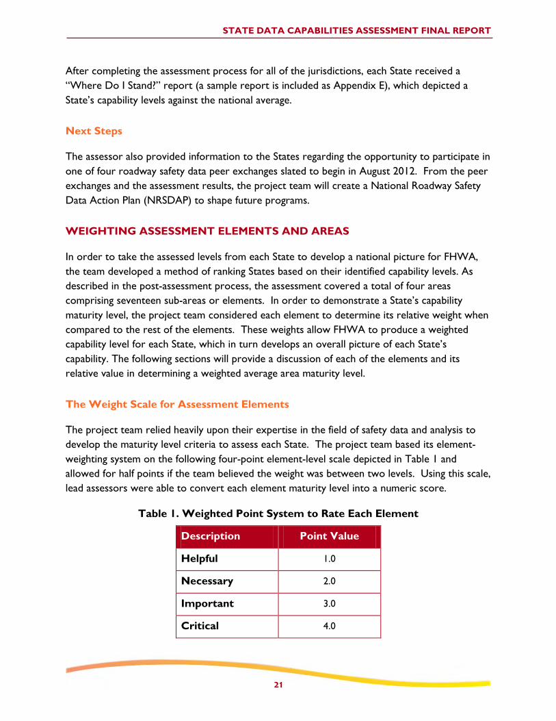
Table 1. Weighted Point System to Rate Each Element
Description Point Value
Helpful 1.0
Necessary 2.0
Important 3.0
Critical 4.0
STATE DATA CAPABILITIES ASSESSMENT FINAL REPORT
22
After each element’s maturity level was converted to a numeric score and weighted, the
process allowed for the creation of an overall average maturity level for that area. While the
team assumed each element was important, some elements (e.g., Element 2A: Network
Screening - Data) will need further refinement and exploration to assign a meaningful weight.
Discussion of Element Weights
The following discussion provides the project team’s rationale related to each assessed element
and their proposed weights.
AREA 1: Data Collection
Element 1A: Completeness (3.5)
Completeness has to do with the amount of the roadway network that is covered by the
inventory database (State, local, or all public roadways). The assessment includes an evaluation
of how well the State’s inventory includes roadway data as outlined in MIRE. This element aims
to cover all public roads inventory. For analysis purposes, many States will view the data that
they have as the complete picture, when in fact key portions of the local roadway network may
not be included. The completeness element was rated between important and critical. It is not
considered to be critical because the team considered that a State’s data capability is not
entirely dependent on completeness.
Element 1B: Timeliness (2.5)
Timeliness relates to how quickly updates are made to roadway data based on any change of
characteristics on the roadway, as well as the process used to enter the change into the
roadway inventory. The team rated the timeliness element between necessary and important.
States strive to obtain data in a timely fashion; however, an immediate update is not critical as
having a solid process to update data. The team felt an update within one year is acceptable for
most safety analysis.
Element 1C: Accuracy (3.0)
Accuracy describes a verification process that covers external checks and internal checks within
the roadway inventory data. The team rated the accuracy element as important. It is not
critical to have internal and external checks; however, this element is more than necessary for
effective safety analysis. The team concluded that accuracy is more important than timeliness.
Element 1D: Uniformity/Consistency (4.0)

STATE DATA CAPABILITIES ASSESSMENT FINAL REPORT
23
Uniformity and consistency are related to the development of consistent roadway data coding
procedures and definitions across years and across different jurisdictions. The team rated this
element as critical. Very little safety analysis can occur without uniform and consistent data and
therefore it is of high importance.
AREA 2: Data Analysis
Element 2A: Network Screening (Data) (No Weight)
The data portion of network screening describes system-wide data analysis incorporating traffic,
road inventory, and crash data along with citation, injury, and driver data. Since the
completeness element already encompasses all these data, this element focuses on whether or
not other safety data are available, such as citation, injury, and driver information. This element
also relates closely to the linkage element (4C). Since the linkage element covers the capability
and not the actual use, the team determined that this element is of lower value in the ranking
method and therefore not weighted. As future pilots demonstrate the benefits of additional
linked data to citation, injury, and driver data to safety analysis tools, the true weight can be
determined.
Element 2A: Network Screening (Method) (3.5)
The method portion of network screening describes the use state-of-the-art methods, such as
safety performance functions (SPF, a form of crash prediction models), to assess safety of sites
relative to sites with similar characteristics. The team rated this element between important
and critical because there is a desire to use the best SPF techniques available. The rating is not
critical because it is an evolving process. As the network screening capability expands to cover
all public roadways due to better roadway safety data, the State’s capability evolves to utilize
the state-of-the-art methods. Eventually, the network screening capability will cover the entire
network as time and resources will allow.
Element 2A: Network Screening (Coverage) (3.0)
The coverage portion of network screening relates to the inclusion of all public roads. The
team rated this element as important because it is important for the State to screen the entire
network, even if it means screening the available network with less sophisticated methods. As
more complete roadway networks and SPFs become available, the network screening will
gradually comprise the entire network. This element ties closely to the completeness,
methods, and linkage elements.
Element 2B: Diagnosis (2.5)

STATE DATA CAPABILITIES ASSESSMENT FINAL REPORT
24
Diagnosis addresses the ability to generate crash statistics, including collision and condition
diagrams, and more scientific analyses by crash type. The team rated the diagnosis element
between necessary and important. While traditional methods have worked well, new diagnosis
methods will lead to better understanding of the contributing factors and point towards more
effective solutions. However, it is not as important as other elements in the assessment
process.
Element 2C: Countermeasure Selection (2.5)
Countermeasure selection describes the State’s access to safety related infrastructure and
peripheral data when selecting countermeasures. Ideally, these data would be electronically
accessible to minimize the need for a site visit. Selection of countermeasure is supported by
advanced diagnostic processes and reliable crash modification factors. A site visit is also viewed
as very important by roadway safety auditors for proper diagnostic and countermeasure
selection and is comparable in importance as diagnosis. This element is ranked between
necessary and important.
Element 2D: Evaluation (3.0)
Evaluation relates to the use of both project-level and program-level safety evaluations using
advanced methods, such as the Empirical Bayes method. The team rated this element as
important. From a researcher’s perspective, it may be of higher importance; however, from a
State perspective it is necessary to meet Federal requirements. Evaluation is important because
it will lead to better accountability and better estimates of the effectiveness of safety
treatments.
Element 2E: Accessibility (2.5)
Accessibility describes the ability for anyone, including the public, to request data, within a
defined timeline. The team rated this element between necessary and important. The team felt
it was important for all safety partners to be able to access the data for future analysis.
AREA 3: Data Management
Element 3A: People (3.5)
People are vital to the management of state data and this element describes widespread and
active participation of state personnel staff in data policies, standards, and procedures. This
element also addresses the importance of data champions and executive support. The team
rated this element between important and critical.
Element 3B: Policies (3.5)
STATE DATA CAPABILITIES ASSESSMENT FINAL REPORT
25
Policies on data management relate to creating and maintaining a comprehensive business plan
with automated procedures for data consistency, accuracy and reliability. The team rated this
element between important and critical.
Element 3C: Technology (3.5)
Technology in data management involves using information technology to assist in managing and
sharing data. This element describes the use of agency-wide tools to audit data and to automate
real-time data collection, monitoring, and adjustment to meet performance targets with
integration of applications and data sources. The team rated this element between important
and critical.
AREA 4: Data Interoperability
Element 4A: Data Interoperability (3.0)
Data interoperability describes the reliable aggregation of data from various sources with the
goal of providing well-rounded information for key decision making. The team rated this
element as important.
Element 4B: Expandability (4.0)
Expandability describes the use of modern database designs with automated data transfers,
integrated analytic tools, and full spatial analysis capabilities. The team ranked this element as
critical. This is a critical step if the State intends to expand their data to cover all public roads.
Element 4C: Linkage (3.5)
Linkage describes the use of a single location coding as the linking data element among all data
sources. The team rated this element between important and critical. Basic linkages are
fundamental and therefore critical; however, there are various techniques for use as surrogates.
WEIGHTING RESULTS
The results of the team decisions on a weighting scheme are presented below. There were two
levels of weights developed – weights for elements (i.e., the sub areas) and weights for the
areas (i.e., the larger aggregated level such as Data Management).
Weighted Element Results
Using the weighting system and a series of discussions, Table 2 presents the following weights
for the assessment elements.

STATE DATA CAPABILITIES ASSESSMENT FINAL REPORT
26
Table 2. Weighted Element Results
Description Point Value
Element 1A: Completeness 3.5
Element 1B: Timeliness 2.5
Element 1C: Accuracy 3.0
Element 1D: Uniformity/Consistency 4.0
Element 2A: Network Screening (Data) Redundant
Element 2A: Network Screening (Method) 3.5
Element 2A: Network Screening (Coverage) 3.0
Element 2B: Diagnosis 2.5
Element 2C: Countermeasure Selection 2.5
Element 2D: Evaluation 3.0
Element 2E: Accessibility 2.5
Element 3A: People 3.5
Element 3B: Policies 3.5
Element 3C: Technology 3.5
Element 4A: Data Interoperability 3.0
Element 4B: Expandability 4.0
Element 4C: Linkage 3.5
Weighted Area Results
The broad areas of the assessment were Roadway Inventory, Data Analysis, Data Management,
and Expandability and Interoperability. As opposed to the element weights, where some
elements were weighted more heavily than others, the team decided that each area should
possess an equal weight. The team recognizes that the most useful scoring for each State
occurs at the element level as all actions center on moving a State’s capability forward at the
element level. The element weights combine to create area and statewide capability levels.
Since a State would have to improve a particular element to advance their capability level
further, only limited benefits exist by focusing on area or statewide maturity levels. From the
States’ perspective, each State should focus on their self-established goals to monitor and
improve their element maturity levels.
STATE DATA CAPABILITIES ASSESSMENT FINAL REPORT
27
For FHWA to manage the national baseline, the team recommends using equally weighted
areas. In order to determine how to provide support to complete gaps, the FHWA should
take a holistic approach such that all areas are advanced where States are willing to participate.
Data Expandability
(XX%)
This State is a Level 4
Data Management
(XX%) This State is a Level 5
Data Collection
(XX%)
This State is a Level 2
Data Analysis
(XX%)
This State is a Level 3
Figure 5. Element Capability Levels are weighted to form basis for Area Capability
Levels
Figure 5 can be averaged to produce an overall numeric score for the State, which can be
converted into the overall capability maturity level.
Figure 6. Area Capability Levels form basis for Overall State Data Capability
For the example provided in the graphic, a Level 3 would be the maturity level Defined, where
the organization generally documents and utilizes a process rather than changing the process on
a per-project basis. The organization's standards tie to an adopted strategy and this guidance
determines project outcomes.
Data Collection
(XX%)
This State is a Level
2
OVERALL
CAPABILITY
Data Analysis
(XX%)
This State is a Level
3
Data Management
(XX%) This State is a Level
5
Data Expandability
(XX%)
This State is a Level
4
TThhiiss SSttaattee iiss aa LLeevveell
33
STATE DATA CAPABILITIES ASSESSMENT FINAL REPORT
28
FINDINGS
This section presents some of the highlights and findings from the State assessments. It also
presents some potential actions that could assist in improving roadway safety data. (Appendix F
provides a complete list of preliminary national actions.) These results come directly from
conversations between the States’ participants and the lead assessors, the completed
questionnaires, as well as the principle investigator’s participation and experience.
FINDINGS ABOUT THE OVERALL ASSESSMENT PROCESS
The assessment process worked well when the States were engaged and could see the
demonstrated benefits of the final products. The States with advanced capabilities spent
significant resources to fill out the questionnaire accurately. Those States that had previously
worked with Federal agencies on other data-related efforts (e.g., the FHWA Highway Safety
Information Systems [HSIS] project) were slightly more in tune with the goals and objectives of
the assessment. For other States, the assessment process was novel and the detailed
exploration of data was an unfamiliar concept.
One of the overwhelming findings, related to both data capability and project approach, is that
each State is truly unique. Various divisions, districts, and regions within a State may operate in
an independent and decentralized manner to collect, use, and manage data. Coupled with the
fact that there are typically multiple data inventory files, it is unlikely that one answer from the
questionnaire would adequately capture the State’s true capability. In these cases, the
questionnaire alone would not yield a consistent and thorough assessment. The conversation
about the answers to the questionnaire proved extremely valuable to the objectives of the
assessment.
States expressed a great value in assembling multiple agencies and professionals together to
respond to the assessment questions. This process led several States to strengthen their
interagency coordination and data ties. Some States found potential blind spots as many of the
questions were never considered before the assessment. The assessment process will lead to
further conversations at the State level.
GENERAL ASSESSMENT FINDINGS
In general, States want to improve their current roadway safety data capabilities and
take the necessary steps to achieve their desired level. Most States are currently in the
process of implementing data improvement projects, where their desired level is higher,
and following a plan for improvement, in one form or another. FHWA has access to
each States desired levels through the States’ post-assessment process documents.

STATE DATA CAPABILITIES ASSESSMENT FINAL REPORT
29
States indicated the need for a focused USDOT effort to increase awareness of the
technical assistance, tools, training, and other resources are available to improve their
roadway safety data.
In some States, the organizational structure and relationships across State agencies and
with localities impede the successful integration and use of roadway safety data.
A few States expressed frustration related to data management. There is a strong need
to feel independent from the rules of others, as the States tend to view the “rule
makers” as not knowing or appreciating the data. There is also a strong need for data
personnel to learn about each other’s data, respect the data steward’s efforts, and to
develop an understanding of how to work with the data steward to improve and
connect to their data.
Capturing data from the locally maintained roadways is an issue in several States.
Coverage of roadway safety data elements is more robust on the State-maintained
roadways; elements collected on the locally maintained roadways are often not included
in the State-level databases.
Various divisions, districts, and regions may maintain separate databases from the
centralized State database in a decentralized method to monitor data. Some States
responding to the questionnaire had multiple answers depending on various databases.
States expressed a need for coordination among Federal agencies in terms of data
reporting requirements. The relationships between Federal agencies may impede data
efforts. Where the Governor’s Highway Safety Office (GHSO) resides, in particular,
seems to have a bearing on this. When the GHSO is separate from the DOT,
institutional barriers can form that prevent relationships from optimizing to improve
safety data and cooperation.
At least one State expressed a strong need to better support the implementation of
SafetyAnalyst through the results of this project. Other States are also looking to
better support their analysis by improving their roadway safety data and believe that the
capabilities assessment process results will assist them.
Key Preliminary Actions
Some States want the FHWA Office of Safety and their respective Division Offices to “get
more involved” with the upper-management (director) level of DOTs. It is critical to success
for the State agencies who work with roadway safety data to demonstrate that how the data are
used is important and critical (i.e., that it is not just about “collecting” the data, but being able

STATE DATA CAPABILITIES ASSESSMENT FINAL REPORT
30
to use the data that really matters). Specifically, these States want to see FHWA share
information to all the involved stakeholders regarding what is important from the FHWA’s
perspective, as well as the State, in terms of making the data useful. These discussions centered
quite a bit on the multitude of IT projects that relate to the crash data. States want the ability
to have detailed recommendations, as well as more specifics, related to resources and
prioritization tools. They also will welcome support from the FHWA Division Offices and the
Office of Safety to advocate for action items in the Strategic Plan that FHWA denotes as critical
to advancing capability levels—particularly as it relates to the use of safety data.
"Demonstrating the value" was a phrase heard on multiple occasions during the assessments
regarding roadway inventory data. Assessment participants often said that they would like to
know the value of gathering additional roadway elements because either they were
unconvinced themselves, or they needed to convince their executive leadership. States also
depend on local agencies for collecting some of their roadway inventory. Many States need
assistance with local agencies, especially with demonstrating to them that there is value in
gathering more detailed roadway safety data. With their limited staff and funding, many State
and local agencies do not understand the value of roadway inventory data. A key
recommendation for FHWA leadership is to demonstrate the value of the roadway inventory
datasets.
KEY FINDINGS FOR AREA 1: DATA COLLECTION
The following highlights some of the key findings under data collection.
There is a need for information on innovative and cost-effective ways to collect
inventory data other than manual field visits. A couple of States gathered data using
instrumented vehicles (light detection and ranging [LIDAR], etc.) but do not have the
funding or expertise to effectively process the data and extract the inventory items.
FHWA can assist States to move innovative collection practices forward.
Elements collected at the State level are not collected at the same level of detail for
locally-maintained roadways or functionally-classified local roads. In general, from a
State-centric perspective, roadway safety data on locally maintained roadways are less
robust than the State-maintained system, particularly related to completeness and
coverage. It is difficult to integrate local data systems based on a lack of linear
referencing.
Many States have resource or institutional issues with expanding their data collection
beyond the State-maintained roadways. One barrier identified was funding for collecting
detailed elements on non-State roads. In some States, it is difficult to justify the cost of
collecting inventory on non-State roads. States are looking for lower-cost options for
data collections, such as GIS, data collection vans, etc. Some States would like FHWA
support for the following activities:

STATE DATA CAPABILITIES ASSESSMENT FINAL REPORT
31
o Widely available “data van” technology with automated extraction and reduction
of data;
o Development of GIS-based tools for collecting data (e.g., for building curve files,
for building intersection files, etc.);
o Software to process LIDAR data on a statewide basis; and
o Video extraction software for use on video log to collect signs, barriers, etc.
Many States expressed interest in collecting or expanding their collection of intersection
data elements.
States do not commonly collect grade and curve data, although many States are working
towards this capability. Some States are attempting to obtain curve-related data from
their existing databases (e.g., GIS) but have not identified the optimal process for such
an effort. It would be beneficial to know if others have had success using a particular
method, software, or vendor to collect these data. FHWA can share this useful
information through best practices, case studies, or webinars.
For data that are collected or will be collected, some States would like to know how to
prioritize data elements to improve the accuracy to get better safety analysis results.
Procedures to prevent stale data and conduct accuracy checks have a wide range of
levels and use in the States.
There is generally good uniformity and consistency of the collected roadway data.
Data quality metrics are more robust with traffic count and crash data than for roadway
inventory data.
States that are not as capable find a way to make their existing data work by developing
information from the data available to them for safety analysis.
Key Preliminary Actions
Conduct case studies to move cost-effective, accurate, and innovative data collection
practices forward. States need examples of how to fund, process, and extract roadway
inventory items.
Pilot and conduct case studies to demonstrate a robust process for States to include
locally owned roadway safety data.
Develop a best or noteworthy practices guide for collecting intersection, curve, and
grade inventory data.
Research a priority list of data elements to improve accuracy through external
verification and validation.
KEY FINDINGS FOR AREA 2: DATA ANALYSIS
The following highlights some of the key findings under data analysis.

STATE DATA CAPABILITIES ASSESSMENT FINAL REPORT
32
Use of data analysis tools and support varies from State to State, with some States using
State-specific tools and some using national tools. Most States find the national tool,
SafetyAnalyst, difficult to implement with their existing data capabilities.
Many States like and use the Crash Modification Factor (CMF) Clearinghouse.
States are excited about implementing the HSM and upgrading their existing analysis
practices. While the HSM provides a common language across the Nation for safety
analysis, each State is unique and creates tools to suit their individual needs. Many
professionals at the State-level noted that the introduction of the HSM was a major
advance for the transportation safety profession.
Network screening and countermeasure selection are dependent on the completeness
and coverage of roadway inventory data. Since localities and local roads have less
coverage, network screening and other aspects of safety analysis may not reflect a
complete picture.
There is an interest in training for local road analysis and what analysis can be
performed with and without the use of SafetyAnalyst (e.g., best practices, peer
exchanges, etc.). States requested advanced training in SafetyAnalyst features,
specifically diagrams and data input needs.
While there are generally no formal accessibility procedures, roadway safety data
managers offer good customer service and access to their data.
Limited resources may constrain the years of historical data that a State retains, which
can affect the ability to conduct some retrospective analyses.
Key Preliminary Actions
Continue to develop training for non-technical users in the use of the HSM methods and
more rigorous analysis methods (e.g., empirical Bayes method).
Develop advanced training and support in SafetyAnalyst to map and link data input needs.
Develop a best practices and/or peer exchange related to data analysis tools and
techniques at the State and national level.
Develop a return on investment to provide additional guidance related to collecting
inventory and traffic data on local roads with very low crash histories. The research would determine the value and provide guidance as to where it is beneficial.

STATE DATA CAPABILITIES ASSESSMENT FINAL REPORT
33
Determine specific policies or resource constraints that may limit the retention of
historic data and develop guidance to address them.
KEY FINDINGS FOR AREA 3: DATA MANAGEMENT
The following highlights some of the key findings under data management.
There was not a wide understanding of data management terminology by State safety
engineers. Data management boards are above the TRCC and the roadway inventory
data stewards. States vary widely on whether the State prefers centralized or
decentralized data management.
In most States, there is not a common platform to discuss data management or
management issues. These terms are not well defined or understood by the States.
There is not a firm understanding or relationship between the IT and safety arenas.
Each discipline does not necessarily understand the other’s language or needs, but
training may help to bridge this gap.
There are strong relationships between people, policies, and technologies. Often, the
institutional barriers are more important to remove than technology barriers.
Relationships affect data linkage at the State level as much as resource issues. Some
TRCCs and safety data improvement plans exist in name only. Some States expressed a
sense of frustration related to data management. There is a potential bridge to be built
between IT professionals and data stewards.
It is difficult to identify one way to approach data management. Most States did not
have a statewide data governing body and several States said they preferred it that way.
They felt that handling data coordination at the State agency level through the TRCC
was the best way. They expressed concern that a statewide body would not appreciate
or respond to specific needs (i.e., heavy-handed treatment that values policies over the
opinions of the agencies that gather and maintain the data).
Sometimes a management element is a leading indicator of a State’s data capability and
sometimes it is a lagging indicator. It depends upon the State and what phase of a data
management cycle the State is in. If a new hire takes the place of a retiree in critical
data management areas, capability may dip temporarily due to their learning curve and
understanding the systems in place.
Several States described a bottleneck in the delivery of IT resources within the DOT.
Roadway safety data improvements were superseded by other DOT priorities.

STATE DATA CAPABILITIES ASSESSMENT FINAL REPORT
34
Some States requested that FHWA create guidance on structuring or integrating data
from various agencies and sources into a comprehensive data clearinghouse.
Some States wanted guidance for data that are collected using Federal funding, such as
reasonable expectations for data to be made available to the public and shared between
agencies.
There are roadway safety data practices that are not known by all of the involved
agencies that use the data. This finding is based on the internal discussions within the
States.
Key Preliminary Actions
Conduct pilots and case studies to identify best and noteworthy practices from highly
ranked data management States.
Develop a common glossary of terms and training for safety professionals to understand
IT terminology and vice versa.
Develop guidance on structuring or integrating data from various agencies and sources
into a comprehensive data clearinghouse.
Develop guidance on expectations for roadway safety data to be made available to the
public and shared between agencies.
KEY FINDINGS FOR AREA 4: DATA INTEROPERABILITY
The following highlights some of the key findings under data interoperability:
Most States are interested in linking roadway inventory data to other databases but do not have that capability.
Most States have some or most of their systems sharing a common platform; yet, they
are probably answering the question based upon what they have with a State-maintained
focus and not including locally-maintained roadways.
Some States questioned the value of linking citation, injury, and driver data to other
safety data as they have unknown safety benefits.

STATE DATA CAPABILITIES ASSESSMENT FINAL REPORT
35
Key Preliminary Actions
Pilot linking citation, injury, and driver data to other safety data to determine the
possible safety benefits.
Vet potential focus States for improving roadway safety data capabilities to support the
vision and goals of the Focused Approach to Safety.
Provide national roadway safety data training modules to enhance the program’s
visibility, consistency, and effectiveness
NATIONAL GAPS SUMMARY
While this summary will provide an initial discussion of gaps identified from the assessment
process, the conversation should continue in the series of Roadway Safety Data Program peer
exchanges scheduled for 2012 and 2013. The chart depicted in Figure 7 presents the national
baseline from the assessments. The assessment team recommends that this capability level be
monitored over time such that FHWA can measure the national performance for the funding
sources provided.
Consistent gaps from a national perspective center on data management policies and
technology, the completeness of the roadway inventory, and countermeasure selection. These
three elements were assessed to be below a “defined” capability level. From the weighting
results, policies, technology, and the completeness are more important than countermeasure
selection when it comes to sustaining safety data capability.
Overall, the Data Management area is the least understood. The average capability in this area
is 2.8 on the five-point scale. A bridge is needed between IT professionals and safety engineers
such that IT policies and technology can better serve decision makers to fund the best safety
improvements. The knowledge, skills, and abilities of involved stakeholders are critical to
improving and sustaining safety data capability. Removing institutional barriers and having high
functioning TRCCs and management boards are important for sustained data capability. Case
studies, best practices, and pilots are needed to support how to best to overcome institutional
barriers related to data management.
The average capability for the Completeness element, within the Roadway Inventory Data
Collection area, is 2.6 on the five-point scale. Many States attributed their identification of a
lower capability due to a lack of complete roadway inventories on locally maintained roadways
and fewer roadway inventory elements collected. Resources need to be identified to support
the collection of the Fundamental Data Elements (FDE). FDEs are a basic set of elements that
an agency would need to conduct enhanced safety analyses regardless of the specific analysis

STATE DATA CAPABILITIES ASSESSMENT FINAL REPORT
36
tools used or methods applied. Appropriate resources are also needed to keep the data
collection efforts timely and reliable, particularly when it comes to the FDEs.
The average capability for the Countermeasure Selection element, within the Data Analysis
Tools and Uses area, is 2.8 on the five-point scale. Specifically in this area, States need better
data in a readily accessible form to support safety analyses. This would include detailed data
elements describing safety-related infrastructure attributes of the roadway and peripheral
database information such as signs, lighting, pavement condition and markings, etc. Proving the
benefits of linking roadway inventory data to citation, injury, and other non-traditional datasets
would also provide a better understanding for States to pursue more advanced roadway
inventory centered analysis.
Figure 7. National Average Baseline for State Data Capability
2.6
3.3
3.7
3.8
3.5
3.6
3.4
4.0
2.8
3.6
4.0
3.1
2.5
2.9
3.1
3.7
3.6
0.0 1.0 2.0 3.0 4.0 5.0
1A: Completeness
1B: Timeliness
1C: Accuracy
1D: Uniformity / Consistency
2A: Network Screening (Data)
2A: Network Screening (Method)
2A: Network Screening (Coverage)
2B: Diagnosis
2C: Countermeasure Selection
2D: Evaluation
2E: Accessibility
3A: People
3B: Policies
3C: Technology
4A: Data Interoperability
4B: Expandability
4C: Linkage
Capability Level
Dat
a C
apab
ility
Ele
me
nt

STATE DATA CAPABILITIES ASSESSMENT FINAL REPORT
37
CONCLUSION
This effort set the national baseline for roadway safety data capability in each of the fifty States,
the District of Columbia and Puerto Rico. This baseline will be useful to target initiatives to
improve State capability levels as indicated by each State DOT. Assessment participants
indicated that the assessment process was fair and provided an accurate perspective of their
current capabilities. Most States were taking steps to improve their capabilities and this report
should only be viewed as a snapshot of their capability.
All States wanted to advance their data capability and many had recommendations for FHWA
to remove barriers and to provide technical assistance and resources. FHWA should continue
to partner with other Federal agencies to review and enhance the action plan templates created
for each State. FHWA should tailor the approach to each State, through consideration of a
“focused approach” category for data improvements or other methods, to implement their
Roadway Safety Data Action Plans in alignment with their safety goals outlined in their Strategic
Highway Safety Plan. While this initiative looked at the State level data capability, parallel work
has revealed that safety data capability at the regional MPO and local level may be quite
different, and in some cases more robust. In future efforts, it is critical to engage these levels of
government to determine the best way forward in any particular State.

STATE DATA CAPABILITIES ASSESSMENT FINAL REPORT
38
APPENDIX A – STATE MATURITY LEVELS
One of the one useful components of this Assessment will be the determination of capability
maturity at the State and national levels. The State Maturity Levels are based on the principles
of the “Capability Maturity Model” – CMM. This approach provides the project team the ability
to subjectively assess the States. The principles of the CMM place each State into “capability
categories.” These categories are based on a five-point scale from less to more mature. The
five maturity levels used in this analysis are listed:
Initial / Ad hoc (Capability Level 1): The organization does not possess a stable
implementation environment and the safety data collection, management
(entering/coding, processing, and evaluating) and maintenance process is ‘ad hoc’ with
no interconnection within the organization. There is no plan for interoperability or
expandability.
Repeatable (Capability Level 2): The results of previous projects and the demands
of the current project drive activities and actions. Individual managers decide what to
do on a case-by-case basis during individual projects.
Defined (Capability Level 3): The organization documents the process rather than
on a per-project basis. The organization's standards tie to an adopted strategy and this
guidance determines project outcomes.
Managed (Capability Level 4): Process management starts and supervises individual
projects. Through performance management, processes are predictable and the
organization is able to develop rules and conditions regarding the quality of the products
and processes.
Optimizing (Capability Level 5): The whole organization focuses on the continuous
improvement. The organization possesses the means to detect weaknesses and to
strengthen areas of concern proactively.
Appendix C contains specific information about each element’s capability maturity level.

STATE DATA CAPABILITIES ASSESSMENT FINAL REPORT
39
Figure 8. Capability Maturity Level Distribution for Data Collection: Coverage
3
26
11 10
1
0
5
10
15
20
25
30
35
Initial(1) Repeatable(2) Defined(3) Managed(4) Optimizing(5)
S
t
a
t
e
s
Capability Level (1A)
Figure 9. Capability Maturity Level Distribution for Data Collection: Timeliness
2
5
22 20
2
0
5
10
15
20
25
30
35
Initial(1) Repeatable(2) Defined(3) Managed(4) Optimizing(5)
S
t
a
t
e
s
Capability Level (1B)

STATE DATA CAPABILITIES ASSESSMENT FINAL REPORT
40
0
3
18
22
8
0
5
10
15
20
25
30
35
Initial(1) Repeatable(2) Defined(3) Managed(4) Optimizing(5)
S
t
a
t
e
s
Capability Level (1C)
Figure 10. Capability Maturity Level for Data Collection: Accuracy
Figure 11. Capability Maturity Level Distribution for Data Collection:
Uniformity/Consistency
2
8 7
15
19
0
5
10
15
20
25
30
35
Initial(1) Repeatable(2) Defined(3) Managed(4) Optimizing(5)
S
t
a
t
e
s
Capability Level (1D)

STATE DATA CAPABILITIES ASSESSMENT FINAL REPORT
41
Figure 12. Capability Maturity Level Distribution for Data Analysis: Network
Screening (Data)
0
4
22 20
5
0
5
10
15
20
25
30
35
Initial(1) Repeatable(2) Defined(3) Managed(4) Optimizing(5)
S
t
a
t
e
s
Capability Level (2AD)
Figure 13. Capability Maturity Level Distribution for Data Analysis: Network
Screening (Methodology)
0
11 12
15 13
0
5
10
15
20
25
30
35
Initial(1) Repeatable(2) Defined(3) Managed(4) Optimizing(5)
S
t
a
t
e
s
Capability Level (2AM)

STATE DATA CAPABILITIES ASSESSMENT FINAL REPORT
42
Figure 14. Capability Maturity Level Distribution for Data Analysis: Network
Screening (Coverage)
1
6
22
16
6
0
5
10
15
20
25
30
35
Initial(1) Repeatable(2) Defined(3) Managed(4) Optimizing(5)
S
t
a
t
e
s
Capability Level (2AC)
Figure 15. Capability Maturity Level Distribution for Data Analysis: Diagnosis
0 1
8
34
8
0
5
10
15
20
25
30
35
40
Initial(1) Repeatable(2) Defined(3) Managed(4) Optimizing(5)
S
t
a
t
e
s
Capability Level (2B)

STATE DATA CAPABILITIES ASSESSMENT FINAL REPORT
43
Figure 16. Capability Maturity Level Distribution for Data Analysis:
Countermeasure Selection
0
25
14
11
1
0
5
10
15
20
25
30
35
Initial(1) Repeatable(2) Defined(3) Managed(4) Optimizing(5)
S
t
a
t
e
s
Capability Level (2C)
Figure 17. Capability Maturity Level Distribution for Data Analysis: Evaluation
2
6
8
28
7
0
5
10
15
20
25
30
Initial(1) Repeatable(2) Defined(3) Managed(4) Optimizing(5)
S
t
a
t
e
s
Capability Level (2D)
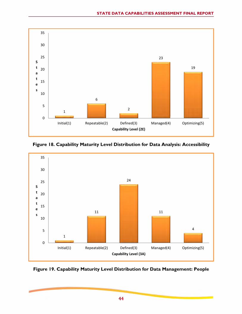
STATE DATA CAPABILITIES ASSESSMENT FINAL REPORT
44
Figure 18. Capability Maturity Level Distribution for Data Analysis: Accessibility
1
6
2
23
19
0
5
10
15
20
25
30
35
Initial(1) Repeatable(2) Defined(3) Managed(4) Optimizing(5)
S
t
a
t
e
s
Capability Level (2E)
Figure 19. Capability Maturity Level Distribution for Data Management: People
1
11
24
11
4
0
5
10
15
20
25
30
35
Initial(1) Repeatable(2) Defined(3) Managed(4) Optimizing(5)
S
t
a
t
e
s
Capability Level (3A)

STATE DATA CAPABILITIES ASSESSMENT FINAL REPORT
45
Figure 20. Capability Maturity Level Distribution for Data Management: Policies
3
25
21
1 1
0
5
10
15
20
25
30
35
Initial(1) Repeatable(2) Defined(3) Managed(4) Optimizing(5)
S
t
a
t
e
s
Capability Level (3B)
Figure 21. Capability Maturity Level Distribution for Data Management:
Technology
1
16
22
10
2
0
5
10
15
20
25
30
35
Initial(1) Repeatable(2) Defined(3) Managed(4) Optimizing(5)
S
t
a
t
e
s
Capability Level (3C)

STATE DATA CAPABILITIES ASSESSMENT FINAL REPORT
46
Figure 22. Capability Maturity Level Distribution for Data Interoperability:
Interoperability
1
8
30
11
1
0
5
10
15
20
25
30
35
Initial(1) Repeatable(2) Defined(3) Managed(4) Optimizing(5)
S
t
a
t
e
s
Capability Level (4A)
Figure 23. Capability Maturity Level Distribution for Data Interoperability:
Expandability
0
3
14
31
3
0
5
10
15
20
25
30
35
Initial(1) Repeatable(2) Defined(3) Managed(4) Optimizing(5)
S
t
a
t
e
s
Capability Level (4B)

STATE DATA CAPABILITIES ASSESSMENT FINAL REPORT
47
Figure 24. Capability Maturity Level Distribution for Data Interoperability: Linkage
1 3
19 20
8
0
5
10
15
20
25
30
35
Initial(1) Repeatable(2) Defined(3) Managed(4) Optimizing(5)
S
t
a
t
e
s
Capability Level (4C)

STATE DATA CAPABILITIES ASSESSMENT FINAL
48
The following table presents the results of each maturity level for the States that completed their assessments.
Table 3. Maturity Level Results
State /
Jurisdiction
Area 1: Data
Collection Area 2: Data Analysis
Area 3: Data
Management
Area 4: Data
Interoperability
1A 1B 1C 1D 2A: Network
Screening 2B 2C 2D 2E 3A 3B 3C 4A 4B 4C
Com
ple
teness
Tim
elin
ess
Acc
ura
cy
Uniform
ity
Dat
a
Meth
od
Cove
rage
Dia
gnosi
s
Counte
r-
meas
ure
Sele
ctio
n
Eva
luat
ion
Acc
ess
ibili
ty
People
Polic
ies
Tech
nolo
gy
Inte
ropera
bili
ty
Expan
dab
ility
Lin
kag
e
1 2 4 5 4 4 4 3 4 3 4 5 4 2 3 3 4 4
2 2 4 5 5 3 4 3 3 2 4 5 3 2 2 3 5 5
3 2 3 4 4 3 2 3 4 2 3 5 4 2 2 3 4 3
4 2 4 3 5 3 3 3 4 2 4 4 3 2 2 3 4 4
5 4 4 5 4 5 5 5 5 5 5 5 4 3 4 4 4 4
6 3 3 4 5 2 3 4 4 2 2 2 2 2 3 2 3 3
7 4 3 4 4 5 5 4 4 3 4 5 3 3 4 3 4 4
8 4 2 4 5 3 2 3 4 3 4 5 3 2 4 3 4 4
9 4 3 4 3 4 5 3 4 2 4 4 4 3 3 3 3 4
10 2 3 3 3 3 3 2 4 2 4 5 3 2 3 3 4 4
11 3 4 4 2 3 3 3 4 2 4 4 4 3 4 3 4 5
12 3 4 4 5 4 5 3 4 3 4 4 4 3 4 4 4 4
13 2 3 3 4 4 5 3 4 3 4 5 5 3 4 4 4 4
14 2 3 4 5 4 4 4 4 4 4 4 3 3 3 4 4 5
15 2 5 3 4 3 2 5 4 3 1 5 1 1 2 3 4 3
16 3 4 4 5 3 5 5 5 4 4 5 2 1 3 3 4 4
17 4 5 4 5 5 3 5 4 4 4 5 5 3 5 4 5 4
18 4 4 4 4 3 2 2 3 2 1 4 3 4 2 2 2 2
19 3 4 4 4 4 4 3 3 3 4 5 3 2 3 4 2 4
20 2 3 5 5 5 3 5 4 4 4 5 3 2 3 4 4 5
21 2 4 5 3 3 3 4 3 2 4 5 4 3 3 3 4 4
22 2 1 4 2 2 2 3 4 2 2 1 2 2 1 2 3 2
23 3 3 3 1 3 3 1 3 3 3 3 2 3 3 3 3 4
24 2 4 4 5 4 2 3 5 3 3 4 2 2 3 3 4 3

STATE DATA CAPABILITIES ASSESSMENT FINAL
49
State /
Jurisdiction
Area 1: Data
Collection Area 2: Data Analysis
Area 3: Data
Management
Area 4: Data
Interoperability
1A 1B 1C 1D 2A: Network
Screening 2B 2C 2D 2E 3A 3B 3C 4A 4B 4C
Com
ple
teness
Tim
elin
ess
Acc
ura
cy
Uniform
ity
Dat
a
Meth
od
Cove
rage
Dia
gnosi
s
Counte
r-
meas
ure
Sele
ctio
n
Eva
luat
ion
Acc
ess
ibili
ty
People
Polic
ies
Tech
nolo
gy
Inte
ropera
bili
ty
Expan
dab
ility
Lin
kag
e
25 3 4 3 3 4 4 2 4 2 5 3 4 3 2 3 4 3
26 4 4 4 5 4 4 5 5 4 5 4 3 3 4 3 4 5
27 2 3 3 5 4 4 3 5 4 5 5 2 2 3 3 4 3
28 2 3 3 4 4 5 4 4 2 4 5 5 5 5 4 4 4
29 2 3 4 4 4 4 4 4 3 3 4 2 2 3 3 5 3
30 4 2 3 4 4 5 3 4 2 5 2 4 3 4 4 4 4
31 3 3 4 3 4 4 4 4 3 4 4 4 3 3 3 3 3
32 4 4 5 4 4 4 4 5 4 4 4 3 3 2 2 4 5
33 1 4 2 4 3 5 3 2 2 4 2 2 2 2 3 3 3
34 5 3 3 5 4 5 3 5 3 4 4 3 2 3 5 4 3
35 2 3 3 5 5 5 4 5 4 5 2 2 2 3 3 3 4
36 3 1 3 2 3 2 3 3 3 4 4 4 3 2 3 4 3
37 2 3 4 5 3 2 3 4 2 4 5 3 2 3 3 4 3
38 1 2 2 5 2 2 2 3 1 1 3 1 1 2 1 1 1
39 2 3 4 3 4 4 3 4 2 5 5 3 2 3 3 4 4
40 2 4 3 1 2 2 3 3 2 3 4 2 2 2 2 3 1
41 2 3 3 5 3 4 2 4 4 4 4 5 3 2 1 4 4
42 2 4 3 2 3 4 4 4 2 4 5 3 3 3 3 3 4
43 2 2 4 2 3 3 4 4 2 4 4 3 2 2 3 4 3
44 2 3 3 2 4 4 4 4 2 4 4 3 1 3 3 2 3
45 2 2 2 2 4 3 3 4 2 3 4 3 2 2 4 3 3
46 1 4 3 2 3 2 4 4 2 2 2 2 2 2 3 3 3
47 3 3 4 5 3 3 4 4 4 4 4 3 3 3 3 3 3
48 2 3 5 5 3 4 3 4 3 2 4 3 2 2 2 3 3
49 4 4 5 5 4 5 4 4 4 3 4 3 3 4 3 4 5
50 3 3 2 4 3 3 2 4 2 2 4 3 3 4 4 4 5
51 2 2 3 3 2 2 4 4 2 2 2 3 2 2 2 3 2
52 1 4 4 4 3 5 2 3 2 3 4 3 2 3 2 4 3

STATE DATA CAPABILITIES ASSESSMENT FINAL REPORT
50
APPENDIX B – EXAMPLE STATE QUESTIONNAIRE

FHWA Roadway Safety Data Partnership
State Roadway Safety Data Capability
Assessment Questionnaire
Example State
Fall 2011
Area 1 Data Collection
1
AREA 1: ROADWAY DATA COLLECTION/TECHNICAL STANDARDS
Background Questions
Element 1A: Completeness
Element 1B: Timeliness
Element 1C: Accuracy
Element 1D: Uniformity/Consistency

Area 1 Data Collection – Background Questions
2
AREA 1: ROADWAY DATA COLLECTION/TECHNICAL STANDARDS
Background Questions
1. Does the State have a basemap of the roadway network?
a. Yes, linear referencing system where each inventory record is a “homogeneous
section” (i.e., all inventory elements/descriptors are constant through the entire
section length) and each record is defined by an “address” such as the route and
milepost of the beginning of each section.
b. Yes, GIS system where the inventory elements/attributes for each ft. (or each x ft.) of
road are stored spatially and can be linked to the GIS base roadway network.
c. Yes, GIS system where the inventory elements are generally consistent along a
segment, however, some may vary slightly and the average, min, or max is used for
that segment.
d. Yes, other (please describe).
e. No (skip #2).
2. What roadways are covered in the basemap?
a. State-owned roadways: 100%
b. Local: 100%

Area 1 Data Collection – Background Questions
3
3. What types of primary roadway data are included in your roadway data inventory system? If
collected, please briefly describe how the data were originally collected.
Data collection techniques/technologies may include: As-built plans (AB), Field survey (FS), Instrumented vehicle
(IV), Aerial Photos (AP), and Other, please describe (O, description).
MIRE Elements Collected How it was collected
I. Roadway Segment Descriptors
Segment Cross Section Yes As-builts, aerials, video log
Roadside Descriptors No N/A
Segment Traffic Flow Data Yes Traffic counts - continuous counters,
spot counts
Segment Traffic Operations/Control Data
Yes Video log, aerials
II. Roadway Alignment (Curve and Grade) Descriptors
No N/A
III. Roadway Junction Descriptors
At-Grade Intersection/Junctions Yes Aerials, video log
Interchange and Ramp Descriptors Yes Aerials, video log
4. Do you have any performance measures/metrics for roadway data? These are defined
measurements made to assess the quality of data. (Check all that apply.)
Completeness.
Timeliness.
Accuracy.
Uniformity/Consistency.
Accessibility.
Interoperability.
Descriptions of these terms are available in the NHSTA Performance Measures White Paper,
http://www-nrd.nhtsa.dot.gov/Pubs/811441.pdf
If so, could you please provide any documentation on what they are, how they are measured,
and how they are tracked.
- None

Area 1 Data Collection – Completeness
4
Element 1A: Completeness
1. What percent of your total roadway system is State maintained?
- 25%
2. What percent of your system has roadway inventory data that are maintained electronically?
a. State-owned roadways: 100%
b. Local: 0%
- State does not collect or have any local roadway data. Only have local roadway centerline file
for the basemap.
3. If the State maintains data on local roads, how is it obtained?
a. State collects data.
b. Local DOT collects data and provides to State.
c. Local MPO/RPO collects data and provides to State.
d. Other (please describe).
- N/A. State does not collect data on local roads.
4. Please describe any data sharing agreements you might have with local agencies.
- N/A. State does not collect data on local roads.

Area 1 Data Collection – Completeness
5
5. What percentage of the MIRE elements are in the inventory file, what percent of roadways are
they collected on, and what elements are planned for future collection?
Worksheet can be found in Appendix A. Additional information on MIRE can be found at http://www.mireinfo.org.
MIRE Elements (# of elements)
Percent of Elements
Percent of Roadways Collected On
Planned Future
Collection
State %
Local%
State (All, Most,
Some, None)
Local (All, Most,
Some, None)
State (Y/N)
Local (Y/N)
I. Roadway Segment Descriptors - Page 56 Appendix A
I.a. Segment Location/Linkage Elements (18)
72% 0% All None --- Y
I.b. Segment Roadway Classification (4)
100% 0% All None --- Y
I.c. Segment Cross Section
I.c.1. Surface Descriptors (8) 75% 0% All None --- Y
I.c.2. Lane Descriptors (12) 42% 0% All None --- Y
I.c.3. Shoulder Descriptors (11) 36% 0% All None --- Y
I.c.4. Median Descriptors (8) 38% 0% All None --- Y
I.d. Roadside Descriptors (13) 0% 0% All None --- N
I.e. Other Segment Descriptors (4) 0% 0% All None --- N
I.f. Segment Traffic Flow Data (12) 33% 0% All None --- Y
I.g. Segment Traffic Operations/Control Data (15)
27% 0% All None --- N
I.h. Other Supplemental Segment Descriptors (1)
0% 0% All None N N
II. Roadway Alignment Descriptors - Page 61 Appendix A
II.a. Horizontal Curve Data (8) 0% 0% All None N N
II.b. Vertical Grade Data (5) 0% 0% All None N N
III. Roadway Junction Descriptors - Page 62 Appendix A
III.a. At-Grade Intersection/Junctions
III.a.1. At-Grade Intersection/Junction - General Descriptors (18)
39% 0% All None --- N
III.a.2. At-Grade Intersection/Junction Descriptors - Each Approach (40)
15% 0% All None --- N
III.b. Interchange and Ramp Descriptors
III.b.1. General Interchange Descriptors (8)
50% 0% All None --- N
III.b.2. Interchange Ramp Descriptors (17)
29% 0% All None --- N
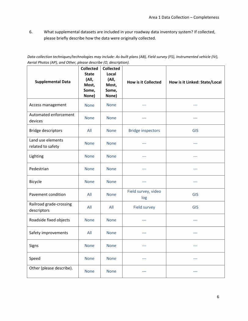
Area 1 Data Collection – Completeness
6
6. What supplemental datasets are included in your roadway data inventory system? If collected,
please briefly describe how the data were originally collected.
Data collection techniques/technologies may include: As-built plans (AB), Field survey (FS), Instrumented vehicle (IV),
Aerial Photos (AP), and Other, please describe (O, description).
Supplemental Data
Collected State (All,
Most, Some, None)
Collected Local (All,
Most, Some, None)
How is it Collected How is it Linked: State/Local
Access management None None --- ---
Automated enforcement
devices None None --- ---
Bridge descriptors All None Bridge inspectors GIS
Land use elements
related to safety None None --- ---
Lighting None None --- ---
Pedestrian None None --- ---
Bicycle None None --- ---
Pavement condition All None Field survey, video
log GIS
Railroad grade-crossing
descriptors All All Field survey GIS
Roadside fixed objects None None --- ---
Safety improvements All None --- ---
Signs None None --- ---
Speed None None --- ---
Other (please describe).
None None --- ---

Area 1 Data Collection – Completeness
7
7. Which inventory file would the State most like to collect for safety purposes if resources (cost,
labor, etc) were not a factor?
a. Roadway segments.
o Cross-section.
o Roadside.
b. Traffic counts.
c. Curves.
d. Grades.
e. Intersections.
f. Interchanges.
g. Ramps.
h. Access management.
i. Automated enforcement devices.
j. Land use elements related to safety.
k. Lighting.
l. Pedestrian.
m. Bicycle.
n. Pavement condition.
o. Roadside fixed objects.
p. Safety improvements.
q. Signs.
r. Speed.
s. Other (please describe). - Local roadway data

Area 1 Data Collection – Timeliness
8
Element 1B: Timeliness
1. What type of procedure do you have to update each of your inventory data types? What is the
time lapse between the “open to traffic” date of a new roadway or roadway modification and
when the revised data are included in each inventory file?
Inventory Type Update Procedure Time Lapse
Roadway Segment On-going 3 months
Traffic Annual (1/3 of roadways
counted each year) 1 month
Intersection On-going 3 months
Interchange On-going 3 months
Ramp On-going 3 months
Curve --- ---
Grade --- ---
Other (please describe)
--- ---
Example procedures might include the following:
I. Ad hoc procedure – no standardized procedure, but changes to the file are made when
they come to the attention of the file maintainer.
II. Annual (or less often) survey of entire or part of the roadway system (e.g., the roadway
system is re-inventoried over a five-year period).
III. On-going “as roadway is modified” process where descriptions or “as-built” plans are
submitted to the file maintainer each time a change is made to the roadway or a new
roadway segment is opened to traffic. The data for the affected section or location are
then updated.
IV. Updates vary by data type.
V. Other (please describe).
Example time lapses might include the following:
I. There is no systematic updating process, thus the time varies greatly.
II. Need time to develop.
III. More than one year.
IV. 6 – 12 months.
V. 1-5 months.
VI. 1 month or less.

Area 1 Data Collection – Timeliness
9
2. If the elapsed time between modification and file entry is much longer for a particular data type,
please describe why.
- N/A
3. Do you indicate the following items in your inventory files, and if so, how? (Check all that
apply.)
Whether an inventory element/item/file was updated. How: ______
Which element/characteristic of that item was updated. How: ______
The date when that updating took place. How: Have a “Date Modified” field that
indicates the date an inventory element was updated.
4. Who can view this indication? (Check all that apply.)
No one.
Internal users (DOT/other State agencies).
External users (local DOTs/MPOs).

Area 1 Data Collection – Accuracy
10
Element 1C: Accuracy
1. Briefly describe how you assess or insure the accuracy of your data.
*If there is a formal documentation of your process – please provide.
- Have computerized internal verification checks. These checks are run on a monthly basis.
2. Do you have a systematic process where all or some part of your inventory data are re-
measured or otherwise verified in the field (e.g., from surveys, video logs, aerial photos, etc.)?
(If the answer differs for different roadway inventory types, please answer for each type.)
- Use aerial photos to re-inventory 1/5 of the State roadways every year.
3. If you do not systematically verify the accuracy of your data, what percentage of the
elements/variables in the file do you estimate contain data that accurately represent “ground
truth” (i.e., are accurate in over 90% of the records)?
Roadway inventory elements: N/A
Traffic inventory elements: N/A
Curve inventory elements (if present): N/A
Grade inventory elements (if present): N/A
Intersection inventory elements (if present): N/A
Interchange inventory elements (if present): N/A
Ramp inventory elements (if present): N/A
Other – please describe: N/A
4. Do you have and continually use a series of computerized internal checks (beyond data type
edits) to insure that data values are legitimate codes or in reasonable ranges and agree with
values for related variables?
- Yes.
If so, what approximate percentage of the fields are checked for logical errors/missing data
(beyond data type edits)?
- 70%

Area 1 Data Collection – Uniformity/Consistency
11
Element 1D: Uniformity/Consistency
1. For all types of existing inventory data on State-system roadways (e.g., roadway segments,
intersections, curves, etc), are element definitions and coding consistent across all highway
divisions/regions? If not, describe differences.
- Yes.
2. If your inventory system contains data on both State-system and local roadways (perhaps from
different jurisdictions), are element definitions and coding consistent across all jurisdictions? If
not, describe the differences for each data type roadways (e.g., roadway segments,
intersections, curves, etc) included.
- N/A (State does not have any data on local roads.)
3. If your inventory data system contains multiple years of data, are there procedures to ensure
that coding for each variable (or critical variables) is consistent across years?
- Yes.
4. Are there procedures in place to ensure that the same “site address” (e.g., route milepost) in the
crash location and roadway inventory file describes the same “site” across multiple years?
- No. Effort is currently underway to work on this problem.

Area 1 Data Collection – Glossary
12
Area 1 Glossary
Accuracy
How accurate the data are. Note that accuracy has two components –
external and internal accuracy. Note that true (“external”) accuracy of
roadway inventory data can only be verified with an “on-road” audit –
survey, photo or video log, aerial photos, etc. Internal accuracy concerns
whether legitimate data values are present and can be monitored through
computerized checks.
Completeness
How much of the roadway inventory data that can potentially be collected
and stored are actually in the final electronic data file.
Computerized internal checks
For coded elements (e.g., pavement type, shoulder type), the entered
value would be compared to legitimate codes and flagged and corrected if
not legitimate. Reasonable ranges might include lane width between 8
and 13 feet or AADT for two-lane rural roads that are non-zero and less
than some reasonable maximum value. “Agreement with related
variables” might mean a shoulder width of zero when a curb is present.
Performance Metrics/Measures
Defined measurements made to assess the quality of data (e.g., time
between roadway modification and modification of roadway inventory
data in the official inventory file.). For safety data (including inventory
data), one or more metrics are defined for each of six data-quality criteria
– accuracy, timeliness, completeness, uniformity/consistency, accessibility
and integration/interoperability.
Roadway inventory types
In this document, primary inventory types surveyed include (1) roadway
segments (e.g., number of lanes, shoulder width, AADT), intersections
(e.g., type, traffic control, crossing street AADT), interchanges (e.g., type of
interchange, lighting), ramps (e.g., ramp AADT, length, type), curves (e.g.,
length, degree of curve) and grades (e.g., percent grade, up or
downgrade). Supplemental information is also collected on roadside
object inventories, sign inventories, speed data inventories and safety
improvement inventories.

Area 1 Data Collection – Glossary
13
Site address
Roadway system screening to identify sites for potential treatment
requires multiple years of crash data. Changes to the roadway system
(e.g., lengthening of a curve; realignment of a roadway section, opening a
new intersection thus creating two segments and one new intersection)
can change the “site address” (route/milepost) for modified and
downstream locations before and after the change.
State-system The roadway network under the control (“owned by”) the State DOT. The
remainder of the public mileage in a State (i.e., “non-State roads”) is
predominately owned by local governments (e.g., county or municipal) or
the federal government (e.g., national park roads).
Timeliness
Difference between date of action (i.e., new roadway open to traffic or
modified/treated roadway opened to traffic) and when the data are
placed in the official file.
Uniformity/Consistency
External consistency refers to the consistency of the elements with
national models or guidelines (such as MIRE). This was examined above
under “Completeness.” Internal consistency refers to uniform/consistent
coding across space (e.g., element definitions and code values are the
same for different jurisdictions) and time (element definitions and coding
are uniform between years).

Area 2 Data Analysis
14
AREA 2: DATA ANALYSIS TOOLS AND USES
Background Questions
Element 2A: Network Screening (Data)
Element 2A: Network Screening (Method)
Element 2A: Network Screening (Coverage)
Element 2B: Diagnosis
Element 2C: Countermeasure Selection
Element 2D: Evaluation
Element 2E: Accessibility

Area 2 Data Analysis – Background Questions
15
AREA 2: DATA ANALYSIS TOOLS AND USES
Background Questions
1. For which of the following roadways are crash data available for analysis? (Check all that apply.)
All State-maintained roadways.
All publicly-owned non-State-maintained roadways (includes county and
local/municipality roads).
All non-public roadways.
A portion of State-maintained roadways.
A portion of publicly-owned non-State-maintained roadways.
A portion of non-public roadways.
2. Does the State have a formal safety planning process?
a. No.
b. Yes.
3. How often does the State conduct a network/system safety assessment?
a. Never.
b. Periodically (please specify).
c. Annually.

Area 2 Data Analysis – Background Questions
16
4. Please indicate in the table below what data analysis tools and resources you are using for network screening, countermeasure selection, and evaluation?
Data Analysis Tools
DATA ANALYSIS PROCEDURES
Network Screening Countermeasure
Selection Evaluation
Highway Safety Manual
Yes (working on it) Yes (working on it) Yes (working on it)
SafetyAnalyst --- --- ---
Interactive Highway Safety Design Model
--- ---
CMF Clearinghouse
Yes
Other (please specify)
--- --- ---

Area 2 Data Analysis – Background Questions
17
5. Please indicate in the table below what resources you rely on for technical assistance in utilizing these tools?
TECHNICAL ASSISTANCE RESOURCES
DATA ANALYSIS TOOLS
Highway Safety
Manual SafetyAnalyst
Interactive Highway
Safety Design Model
CMF Clearinghouse
Other (please specify)
Internal Support within State DOT
X --- --- --- ---
Universities --- --- --- --- ---
AASHTO X --- --- --- ---
FHWA Division Office
X --- --- X ---
FHWA Headquarters Office of Safety
X --- --- --- ---
FHWA Geometric Design Lab
--- --- --- --- ---
NHTSA --- --- --- --- ---
Other (please specify)
--- --- --- --- ---
None (we do not use technical assistance)
--- X X --- X

Area 2 Data Analysis – Background Questions
18
6. Please indicate in the table below which roadway statistics are available for segments, which
roadway types they are available, and what types of analysis they are available for.
Analysis Types: Network screening (NS), Condition diagrams (CD), Countermeasure selection (CS), and Other- please
describe (O, description).
DATA TYPE
ROADWAY TYPE
State (All, Most,
Some, None)
Local (All, Most,
Some, None)
Non-public roadways (All, Most,
Some, None)
Analysis Type* (NS,
CD, CS, O-d)
Number of lanes per direction All None None NS, CD
Location of access points None None None ---
Median type All None None NS, CD
Median width All None None NS, CD
Posted speed All None None NS
Functional classification (e.g., arterial, collector, local)
All None None NS
Area type (e.g., urban, suburban, rural)
All None None NS
Adjacent land use None None None ---
Curvature (e.g., curve/tangent, degree of curve)
None None None ---
Grade None None None ---
Traffic volume All None None NS
This information can be gathered from Element 1A.

Area 2 Data Analysis – Background Questions
19
7. Please indicate in the table below which roadway statistics are available for intersections, which
roadway types they are available, and what types of analysis they are available for.
Analysis Types: Network screening (NS), Condition diagrams (CD), Countermeasure selection (CS), and Other- please
describe (O, description).
DATA TYPE
ROADWAY TYPE
State (All, Most,
Some, None)
Local (All, Most,
Some, None)
Non-public roadways (All, Most,
Some, None)
Analysis Type* (NS,
CD, CS, O-d)
Traffic control (e.g., signalized, two-way stop control, yield, etc.)
All None None NS, CD
Number of approaches (e.g., 3-legged or 4-legged)
All None None NS, CD
Cross-section by approach (e.g., number of through/turn lanes)
All None None NS, CD
Functional classification None None None ---
Area type None None None ---
Traffic volume None None None ---
Turning movement counts None None None ---
Posted speed None None None ---
Location of access points None None None ---
Adjacent land use None None None ---
Median presence None None None ---
This information can be gathered from Element 1A.

Area 2 Data Analysis – Background Questions
20
8. Please indicate in the table below which roadway statistics are available for ramp and ramp
terminals, which roadway types they are available, and what types of analysis they are available
for.
Analysis Types: Network screening (NS), Condition diagrams (CD), Countermeasure selection (CS), and Other, please
describe (O, description).
DATA TYPE
ROADWAY TYPE
State (All, Most,
Some, None)
Local (All, Most,
Some, None)
Non-public roadways (All, Most,
Some, None)
Analysis Type* (NS, CD, CS, O-d)
Interchange type (e.g., diamond, cloverleaf, etc.)
All None None NS, CD
Traffic control at ramp terminal (e.g., signalized, two-way stop control, yield, etc.)
None None None ---
Cross-section All None None NS, CD
Functional classification All None None NS, CD
Area type All None None NS, CD
Adjacent land use None None None ---
Advisory or posted speed None None None ---
Traffic volume All None None NS
Curvature None None None ---
Grade None None None ---
This information can be gathered from Element 1A.

Area 2 Data Analysis – Background Questions
21
9. Please indicate in the table below which roadway statistics are available for at-grade rail
crossings, which roadway types they are available, and what types of analysis they are available
for.
Analysis Types: Network screening (NS), Condition diagrams (CD), Countermeasure selection (CS), and Other, please
describe (O, description).
DATA TYPE
ROADWAY TYPE
State (All, Most,
Some, None)
Local (All, Most,
Some, None)
Non-public roadways (All, Most,
Some, None)
Analysis Type* (NS,
CD, CS, O-d)
Type of crossing (e.g., active or passive)
All None None NS
Traffic control of crossing (e.g., signalized, stop control, gates, cross bucks etc.)
All None None NS
Number of roadway lanes All None None NS
Number of tracks All None None NS
Functional classification of roadway All None None NS
Area type All None None NS, CD
Adjacent land use None None None ---
Traffic volume on roadway All None None NS
Number of trains per day All None None NS
Roadway curvature None None None ---
Roadway grade None None None ---
This information can be gathered from Element 1A.

Area 2 Data Analysis – Background Questions
22
10. Please indicate below which peripheral databases are available for determining existing safety-
related infrastructure attributes and for which roadway types they are available for.
Analysis Types: Network screening (NS), Condition diagrams (CD), Countermeasure selection (CS), and Other, please
describe (O, description).
DATA TYPE
ROADWAY TYPE
State (All, Most,
Some, None)
Local (All, Most,
Some, None)
Non-public roadways (All, Most,
Some, None)
Analysis Type* (NS,
CD, CS, O-d)
Access Management None None None ---
Automated enforcement devices None None None ---
Land use elements related to safety None None None ---
Lighting None None None ---
Pedestrian None None None ---
Bicycle None None None ---
Pavement condition All None None NS
Roadside fixed objects None None None ---
Safety improvements None None None ---
Signs None None None ---
Speed data None None None ---
Other (please specify).
Bride descriptors All None None NS
This information can be gathered from Element 1A.
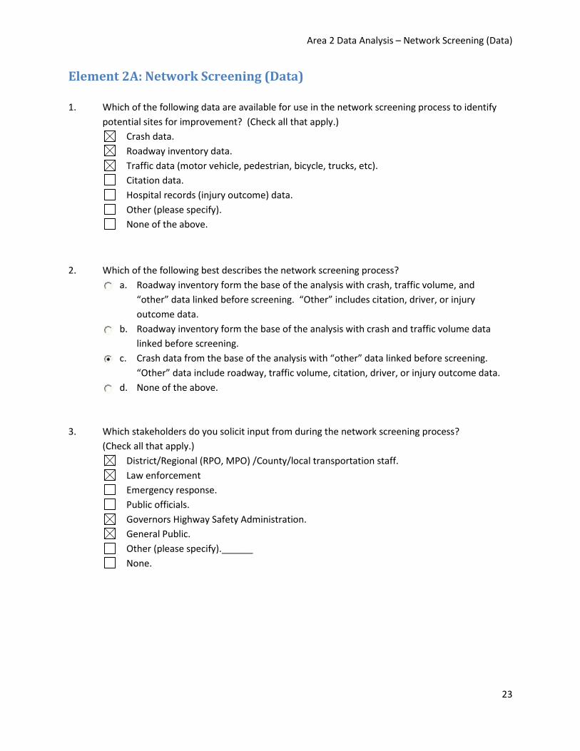
Area 2 Data Analysis – Network Screening (Data)
23
Element 2A: Network Screening (Data)
1. Which of the following data are available for use in the network screening process to identify
potential sites for improvement? (Check all that apply.)
Crash data.
Roadway inventory data.
Traffic data (motor vehicle, pedestrian, bicycle, trucks, etc).
Citation data.
Hospital records (injury outcome) data.
Other (please specify).
None of the above.
2. Which of the following best describes the network screening process?
a. Roadway inventory form the base of the analysis with crash, traffic volume, and
“other” data linked before screening. “Other” includes citation, driver, or injury
outcome data.
b. Roadway inventory form the base of the analysis with crash and traffic volume data
linked before screening.
c. Crash data from the base of the analysis with “other” data linked before screening.
“Other” data include roadway, traffic volume, citation, driver, or injury outcome data.
d. None of the above.
3. Which stakeholders do you solicit input from during the network screening process?
(Check all that apply.)
District/Regional (RPO, MPO) /County/local transportation staff.
Law enforcement
Emergency response.
Public officials.
Governors Highway Safety Administration.
General Public.
Other (please specify).______
None.

Area 2 Data Analysis – Network Screening (Method)
24
Element 2A: Network Screening (Method)
4. Which of the following “networks” can be identified for network screening?
(Check all that apply.)
Segments.
Facilities/corridors.
Intersections - Signalized.
Intersections - Unsignalized.
Ramps.
Ramp terminals.
At-grade rail crossings.
5. Which of the following performance measures are used in the network screening process?
(Check all that apply.)
Average observed crash frequency.
Crash rate.
Equivalent property damage only (EPDO) average crash frequency.
Relative severity index.
Critical rate.
Excess predicted average crash frequency using method of moments.
Level of service of safety.
Excess predicted average crash frequency using safety performance functions
(EB adjustments).
Probability of specific crash types exceeding threshold proportion.
Excess proportions of specific crash types (using statistical methods in HSM).
Expected average crash frequency with empirical Bayes adjustments.
Equivalent property damage only (EPDO) average crash frequency with empirical Bayes
adjustments.
Excess expected average crash frequency with empirical Bayes adjustments.
Descriptions of these terms are available on page 60 (2-20) of the FHWA HSIP Manual,
http://safety.fhwa.dot.gov/hsip/resources/fhwasa09029/fhwasa09029.pdf.
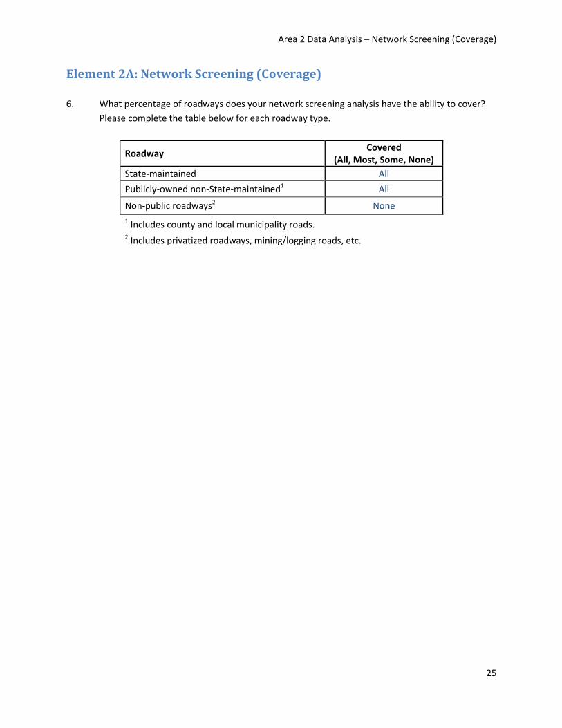
Area 2 Data Analysis – Network Screening (Coverage)
25
Element 2A: Network Screening (Coverage)
6. What percentage of roadways does your network screening analysis have the ability to cover?
Please complete the table below for each roadway type.
Roadway Covered
(All, Most, Some, None)
State-maintained All
Publicly-owned non-State-maintained1 All
Non-public roadways2 None
1 Includes county and local municipality roads. 2 Includes privatized roadways, mining/logging roads, etc.

Area 2 Data Analysis – Diagnosis
26
Element 2B: Diagnosis 1. Does the State have the ability to generate crash statistics for a specific site or corridor?
a. No (skip #2).
b. Yes.
2. Please indicate below which crash statistics can be generated for a specific site or corridor and
for which roadway types they are available by filling “all”, “some”, or “none” in each box.
DATA TYPE
ROADWAY TYPE
State-maintained roadways
Publicly-owned non-State-maintained roadways
Non-public roadways
Crash type All All None
Crash severity All All None
Time of crash All All None
Day of crash All All None
Date of crash All All None
Road condition (dry, wet, etc.) All All None
Lighting condition (light, dark-lit, etc.) All All None
Weather condition (clear, rain, snow) All All None
Contributing factors All All None
Driver impairment All All None
Driver age All All None
Object hit All All None
Direction of travel All All None
Specific location of crash (e.g., within an intersection, on east approach, off the right roadside, etc.)
None None None

Area 2 Data Analysis – Diagnosis
27
3. Does the State have the ability to generate a collision diagram?
a. No.
b. Yes, manual.
c. Yes, manual/automated combination.
d. Yes, automated.
4. Does the State have the ability to generate a condition diagram?
a. No.
b. Yes, manual.
c. Yes, manual/automated combination.
d. Yes, automated.

Area 2 Data Analysis – Countermeasure Selection
28
Element 2C: Countermeasure Selection There are no further questions under this section. Relevant information for this section can be obtained
from responses to questions in the “Background” section.

Area 2 Data Analysis – Evaluation
29
Element 2D: Evaluation
1. Does the State maintain records for roadway safety improvement projects?
a. No.
b. Yes. - Projects on State-system roads only.
2. What types of information are available for safety improvement projects? (Check all that apply.)
Installation date.
Location.
Project type (e.g., rumble strip, sign upgrade, signal upgrade).
Project cost.
3. Does the State have the ability to link crash data to the safety improvement project site(s) of
interest? If so, how many years of historical crash data are available?
a. No.
b. Yes. Number of years available: 11 years (since 2000)
4. Does the State have the ability to link annual traffic data (ADT or AADT) to the safety
improvement project site(s) of interest? If so, how many years of reliable historical traffic
volume data are available?
a. No.
b. Yes. Number of years available: 15 years
5. Do the years of crash data correspond with the exposure data (traffic counts or VMT)?
a. No.
b. Yes. - Have exposure data for all the years of crash data (but do not have crash data
for all the years of exposure data).
6. Does the State have the ability to define specific reference or comparison groups (e.g., rural,
four-legged, signalized intersections) with associated traffic and crash data to be used as non-
treatment sites?
a. No.
b. Yes. - Only on the State-system roads.

Area 2 Data Analysis – Evaluation
30
7. Does the State have the ability to identify non-treatment sites for any/all portions of the
network?
a. No.
b. Yes. - Only on the State-system roads.

Area 2 Data Analysis – Accessibility
31
Element 2E: Accessibility
1. Does the State have a formal process for requesting roadway inventory data?
a. No.
b. Yes.
2. Which of the following safety partners have direct access (i.e., via internal computer network or
internet) to inventory data? (Check all that apply.)
Top-level decision-makers.
All divisions within DOT.
Specific divisions within DOT (please specify). - Only data managers
All safety partners outside of DOT, excluding the public.
Some safety partners outside of DOT, excluding the public (please specify). ______
Public.
3. For those that do not have direct access, which of the following safety partners can request and
receive access to or information from the State roadway inventory database? (Check all that
apply.)
Top-level decision-makers.
All divisions within DOT.
Specific divisions within DOT (please specify). ______
All safety partners outside of DOT, excluding the public.
Some safety partners outside of DOT, excluding the public (please specify). ______
Public.
4. Does the State have a defined timeline for filling data requests? If so, which of the following
best describes the State’s policy for filling data requests?
a. No.
b. Yes, varies; not managed.
c. Yes, policy in place and loosely followed.
d. Yes, policy actively managed.
e. Yes, real-time response; part of the organization.
f. Yes, real-time response with advanced visualization tools and feedback sought.

Area 2 Data Analysis – Accessibility
32
5. Does the State measure users’ satisfaction with data accessibility (e-mail, online satisfaction
survey, etc)?
a. No.
b. Yes.

Area 2 Data Analysis – Glossary
33
Area 2 Glossary
Accessibility A measure of how easy is it to retrieve and manipulate data in a system, in particular by those entities that are not the data system owner.
Before-after study The evaluation of implemented safety treatments, accomplished by comparing frequency or severity of crashes before and after implementation. There are several different types of before-after studies. These studies often develop crash modification factors for a particular treatment or group of treatments. Also known as BA studies.
Condition diagram Similar to a collision diagram, but instead of crash information, it provides detailed site characteristics and information on the surrounding land uses.
Critical rate A method in which the observed crash rate at each site is compared to a calculated critical crash rate that is unique to each site.
Cross-sectional study Studies comparing the crash frequency or severity of one group of entities having some common feature (e.g., STOP controlled intersections) to the crash frequency or severity of a different group of entities not having that feature (e.g., YIELD controlled intersections), in order to assess difference in crash experience between the two features (e.g., STOP versus YIELD sign).
Diagnosis The identification of factors that may contribute to a crash.
Equivalent property damage only
Rather than looking at crash severities separately, this measure combines all crashes using a weighted average. Specifically, it converts all crashes to property damage only crashes, so an injury crash represents X PDO crashes and a fatal crash represents Y PDO crashes.
Excess predicted average crash frequency
Method in which sites are ranked according to the difference between the observed crash frequency and the predicted crash frequency based on a safety performance function.
Expected crashes An estimate of long range average number of crashes per year for a particular type of roadway or intersection.
Level of service of safety The ranking of sites according to their observed and expected crash frequency for the entire population, where the degree of deviation is then labeled into four level of service classes.

Area 2 Data Analysis – Glossary
34
Method of moments Method in which a site’s observed accident frequency is adjusted based on the variance in the crash data and average crash counts for the site’s reference population.
Network screening Process by which State or local agencies identify sites with “safety issues”. This is an initial cut at identifying sites with potential for treatment. Further studies are necessary (diagnosis) to determine specific issues and appropriate treatments.
Non-public roadways Includes privatized roadways, mining and logging roads, etc that are not operated or maintained by the State.
Performance threshold A numerical value that is used to establish a threshold of expected number of crashes (i.e. safety performance) for sites under consideration.
Predicted crashes The estimate of long-term average crash frequency which is forecast to occur at a site using a predictive model found in Part C of the Highway Safety Manual. The predictive models in the HSM involve the use of regression models, known as Safety Performance Functions, in combination with Crash Modification Factors and calibration factors to adjust the model to site-specific and local conditions.
Publicly-owned non-State-maintained roadways
Includes county and local/municipality roads that are not maintained by the State.
Regression-to-the-mean Describes a situation in which crash rates are artificially high during the before period and would have been reduced even without an improvement to the site. Variations at a site are usually due to the normal randomness of crash occurrence. Because of random variation, the extreme cases chosen in one period are very likely to experience lower crash frequencies in the next period – the highest get lower and the lowest get higher.
Relative severity index An average crash cost calculated based on the crash types at each site and then compared to an average crash cost for sites with similar characteristics to identify those sites that have a higher than average crash cost. The crash costs can include direct crash costs accounting for economic costs of the crashes only; or account for both direct and indirect costs.

Area 2 Data Analysis – Glossary
35
Safety performance functions
An equation used to estimate or predict the average crash frequency per year at a location as a function of traffic volume and in some cases roadway or intersection characteristics (e.g. number of lanes, traffic control, or median type).
SafetyAnalyst A set of software tools which utilizes SPFs for evaluating roadway locations and contains over 100 SPFs for various roadway segment types. SafetyAnalyst includes modules for identifying locations for potential safety improvement, diagnosis and countermeasure selection, economic appraisal and priority ranking, and evaluation of implemented improvements.
Temporal trends Time-related factors that influence reported crashes and can change throughout a given study period, including crash reporting thresholds, weather conditions, etc.

Area 3 Data Management
36
AREA 3: DATA MANAGEMENT AND GOVERNANCE
Background Questions
Element 3A: People
Element 3B: Policies
Element 3C: Technology
Area 3 Data Management – Background Questions
37
AREA 3: DATA MANAGEMENT AND GOVERNANCE
Background Questions
1. Which of the following systems operate under a modern system?
(Check all that apply.)
Roadway Inventory Data.
Traffic Data.
Crash Data.
Citation / Adjudication Data.
Injury Data.
Driver Data.
Vehicle Data.
2. Which of the following systems are currently being upgraded or planned to have an upgrade in
the next two years from a legacy platform to a modern system? (Check all that apply.)
Roadway Inventory Data.
Traffic Data.
Crash Data.
Citation / Adjudication Data.
Injury Data.
Driver Data.
Vehicle Data.
3. Is there a process to coordinate safety data needs between agencies?
a. No (Skip #4).
b. Yes.
4. If present, is the process to coordinate safety data needs between agencies effective in
capturing user needs?
a. No.
b. Yes.

Area 3 Data Management – People
38
Element 3A: People
Executive Level Management
1. Are executives aware of data problems if they exist?
a. No.
b. Yes.
2. Is there awareness at an executive level of the need for an institutional arrangement or
organizational structure to support data governance?
a. No.
b. Yes.
3. Is there a data governance board or council that has the authority to establish policies for the
management of data and information/directs data management activities of the DOT/State?
The TRCC would report to this governance board.
a. No (Skip #4-6).
b. Yes.
4. Is this board within the DOT or across all State agencies?
a. Within the DOT.
b. Across all State agencies.
5. Does the governance board include safety-related data representatives?
a. No.
b. Yes, includes some safety-related data representatives.
c. Yes, includes most safety-related data representatives.
d. Yes, includes all safety-related data representatives (roadway inventory, crash, traffic,
injury / CODES, citation, driver).

Area 3 Data Management – People
39
6. Is there an executive leadership level within the DOT (that would report to the governance
board)?
a. No.
b. Yes, includes some safety-related data (refers to roadway OR traffic OR crash data).
c. Yes, includes most safety-related data (refers to roadway AND traffic AND crash data).
d. Yes, includes all safety-related data (Refers to answer “c” plus other data).
e. N/A, governance board is within the DOT.
Traffic Records Coordinating Committee
7. What is the role/responsibility of the TRCC in the State?
- Advise and coordinate.
- TRCC and subcommittees meet as needed.
8. Who is represented on the executive leadership level of the TRCC? (Check all that apply.)
Roadway Inventory Data.
Traffic Data.
Crash Data.
Citation / Adjudication Data.
Injury Data.
Driver Data.
Vehicle Data.
Other (please specify).
Safety Data Improvement
9. Is there a safety data improvement plan?
a. No (Skip #10).
b. Yes.

Area 3 Data Management – People
40
10. Does the plan include a clear strategic vision as an organizing principle for Statewide safety data
projects/programs?
a. No.
b. Yes, includes some safety-related data (refers to roadway OR traffic OR crash data).
c. Yes, includes most safety-related data (refers to roadway AND traffic AND crash data).
d. Yes, includes all safety-related data (Refers to answer “c” plus other data).
Who is Active in Data Management?
11. Are there data champions for the following safety data areas? (Check all that apply.)
Roadway Inventory Data.
Traffic Data.
Crash Data.
Citation / Adjudication Data.
Injury Data.
Driver Data.
Vehicle Data.
Other (please specify). ______
12. How active are data stewards related to safety data management?
a. Continuously seeking improvement.
b. Independently active with little coordination.
c. Some limited activity.
d. Not active.
13. Do some IT personnel from the DOT participate in the development and implementation of a
data management program at the state level?
a. No.
b. Yes.

Area 3 Data Management – Policies
41
Element 3B: Policies
1. Is there a program or process at the state level to improve the management of safety data?
a. No (Skip #2-4).
b. Yes.
2. Has a strategic traffic records improvement plan been developed to support management of
core data programs across the agency and has been incorporated into the overall State strategic
plan?
a. No. – Not other than 408 application
b. Yes.
3. Is there a data catalog with data definitions, standards, policies, and procedures for the
collection and use of data available electronically in the organization and is it accessible to
users?
a. No.
b. Yes.
4. Has a Data Business Plan been developed or the State is developing a Data Business Plan to
support management of strategic safety data programs?
a. No.
b. Yes.
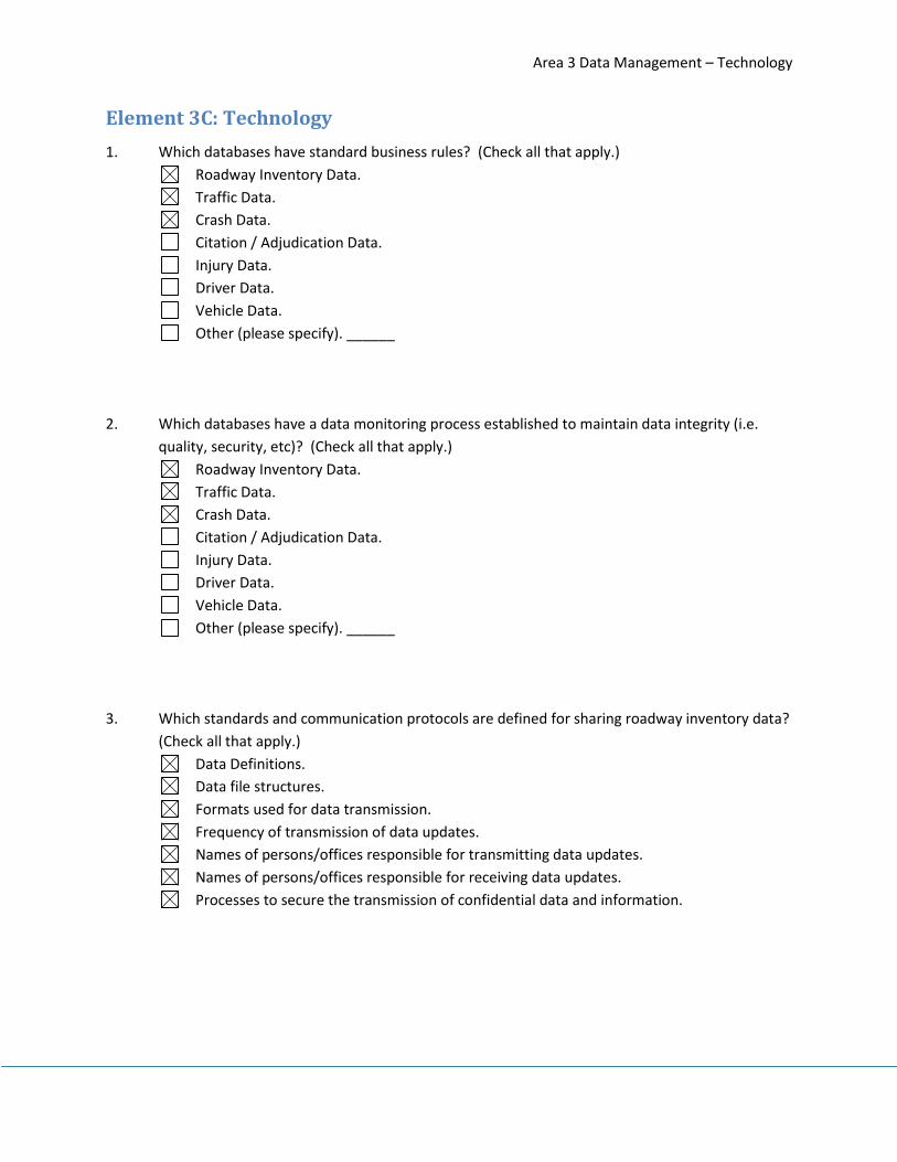
Area 3 Data Management – Technology
42
Element 3C: Technology
1. Which databases have standard business rules? (Check all that apply.)
Roadway Inventory Data.
Traffic Data.
Crash Data.
Citation / Adjudication Data.
Injury Data.
Driver Data.
Vehicle Data.
Other (please specify). ______
2. Which databases have a data monitoring process established to maintain data integrity (i.e.
quality, security, etc)? (Check all that apply.)
Roadway Inventory Data.
Traffic Data.
Crash Data.
Citation / Adjudication Data.
Injury Data.
Driver Data.
Vehicle Data.
Other (please specify). ______
3. Which standards and communication protocols are defined for sharing roadway inventory data?
(Check all that apply.)
Data Definitions.
Data file structures.
Formats used for data transmission.
Frequency of transmission of data updates.
Names of persons/offices responsible for transmitting data updates.
Names of persons/offices responsible for receiving data updates.
Processes to secure the transmission of confidential data and information.

Area 3 Data Management – Technology
43
4. Do you have a software maintenance cycle for roadway data?
a. No.
b. Yes.
5. Are the data an integral part of any performance management tools with targets set to monitor
the progress towards the State’s vision for highway safety?
a. No.
b. Yes.
6. What information technology tools does the State use on a widespread basis to integrate
business data from various offices through a web-enabled interface for access statewide?
(Check all that apply.)
Enterprise data warehouse.
GIS.
Data Models.
Data repositories.
Data dictionaries
Data cleansing / Data standardization.
None of the above.
7. Do agencies delegate the responsibility to a specific office, such as Information Technology, to
determine what IT tools are needed to support data management across the agency?
a. No.
b. Yes.

Area 3 Data Management – Glossary
44
Area 3: Glossary
Business Rule A business rule is a statement that describes a business policy or
procedure. Usually business rules are expressed at the atomic level -- that
is, they cannot be broken down any further.
Data Governance Plan The initial step in the implementation of a data governance program
involves defining the owners or custodians of the data assets in the
enterprise. A policy must be developed that specifies who is accountable
for various portions or aspects of the data, including its accuracy,
accessibility, consistency, completeness, and updating. Processes must be
defined concerning how the data are to be stored, archived, backed up,
and protected from mishaps, theft, or attack. A set of standards and
procedures must be developed that defines how the data are to be used
by authorized personnel. Finally, a set of controls and audit procedures
must be put into place that ensures ongoing compliance with government
regulations.
Data Governance Board
or Council
Serves as the primary governing body for the management of data
systems. This governing body is usually comprised of senior level
managers who have authority to establish policies for the management of
data and information on behalf of the agency, or State. Governance is not
always at the DOT level. In some cases, it might be at a higher Investment
Review Board (IRB) level or Chief Information Officer (CIO) level – such as a
central State Office of Administrative and Technology Services (OATS).
Data Stewards Individuals responsible for ensuring that the data which are collected,
maintained, and used in the agency are managed according to policies
established by the data governance board or council.
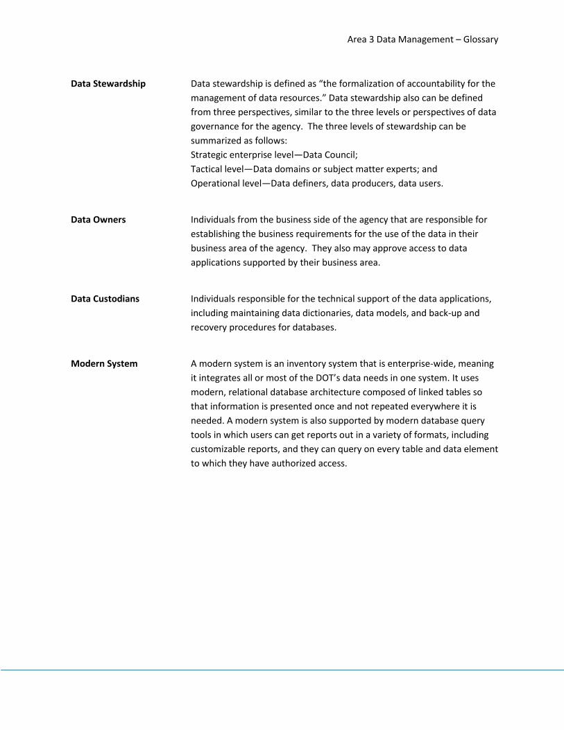
Area 3 Data Management – Glossary
45
Data Stewardship Data stewardship is defined as “the formalization of accountability for the
management of data resources.” Data stewardship also can be defined
from three perspectives, similar to the three levels or perspectives of data
governance for the agency. The three levels of stewardship can be
summarized as follows:
Strategic enterprise level—Data Council;
Tactical level—Data domains or subject matter experts; and
Operational level—Data definers, data producers, data users.
Data Owners Individuals from the business side of the agency that are responsible for
establishing the business requirements for the use of the data in their
business area of the agency. They also may approve access to data
applications supported by their business area.
Data Custodians Individuals responsible for the technical support of the data applications,
including maintaining data dictionaries, data models, and back-up and
recovery procedures for databases.
Modern System A modern system is an inventory system that is enterprise-wide, meaning
it integrates all or most of the DOT’s data needs in one system. It uses
modern, relational database architecture composed of linked tables so
that information is presented once and not repeated everywhere it is
needed. A modern system is also supported by modern database query
tools in which users can get reports out in a variety of formats, including
customizable reports, and they can query on every table and data element
to which they have authorized access.

Area 4 Data Interoperability
46
AREA 4: DATA INTEROPERABILITY AND EXPANDABILITY
Element 4A: Data Interoperability
Element 4B: Expandability
Element 4C: Linkage

Area 4 Data Interoperability – Interoperability
47
AREA 4: DATA INTEROPERABILITY AND EXPANDABILITY
Element 4A: Interoperability
1. Which best describes your State’s ability to support an analysis associating roadway attributes
(geometrics) with crash frequency?
a. No, it is not possible.
b. Could do it but it would require extensive manual effort.
c. Our GIS could map attributes and crashes in separate layers.
d. We could easily produce an analysis for State-maintained roads only.
e. We could easily produce an analysis for all public roads.
f. We could do the analysis and support joint mapping of attributes and crash
experience (i.e., our GIS also has spatial analysis features).
2. Which best describes your State’s ability to support an analysis of the consequences of crashes
from a health perspective, incorporating information on roadway locations, types of
roadways/attributes, and medical treatments (EMS, trauma care, in-patient billing, etc.)?
a. We have not considered this type of analysis.
b. We are not interested in this type of analysis.
c. We are interested in this type of analysis but are unable to conduct it at this time due
to a lack of data.
d. We were a CODES State and formerly conducted this kind of analysis but we no longer
have CODES.
e. We are in the process of developing this capability.
f. We have a system in place (including CODES systems) and regularly conduct this
analysis.
3. Which best describes your State’s ability to support analysis linking the safety-related
enforcement activities (citations/arrests) and crashes with particular roadway
features/attributes or locations by type?
a. We have not considered this type of analysis.
b. We are not interested in this type of analysis.
c. We are interested in this type of analysis but are unable to conduct it at this time due
to a lack of data.
d. We formerly conducted this kind of analysis but decided not to continue.
e. We are in the process of developing this capability.
f. We have a system in place and regularly conduct this analysis.

Area 4 Data Interoperability – Interoperability
48
4. Which best describes your State’s ability to support analysis linking crash types to roadway
geometry or other features (e.g., identifying locations with a propensity for rollovers, run-off-
road crashes, or other) and then analyzing the network for similar locations based on similarity
of roadway attributes?
a. We have not considered this type of analysis.
b. We are not interested in this type of analysis.
c. We are interested in this type of analysis but are unable to conduct it at this time due
to a lack of data.
d. We formerly conducted this kind of analysis but decided not to continue.
e. We are in the process of developing this capability.
f. We have a system in place and regularly conduct this analysis.
5. Which best describes your State’s ability to support analysis linking driver characteristics and
safety/conviction history with particular roadway features/attributes or locations by type?
a. We have not considered this type of analysis.
b. We are not interested in this type of analysis.
c. We are interested in this type of analysis but are unable to conduct it at this time due
to a lack of data.
d. We formerly conducted this kind of analysis but decided not to continue.
e. We are in the process of developing this capability.
f. We have a system in place and regularly conduct this analysis.
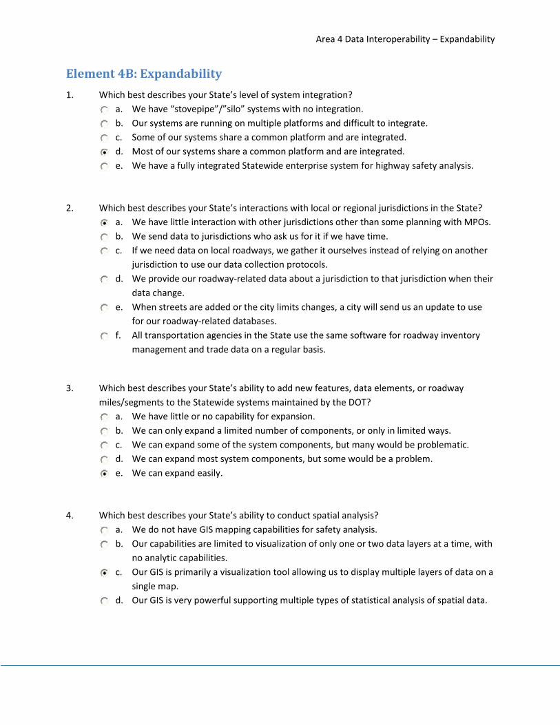
Area 4 Data Interoperability – Expandability
49
Element 4B: Expandability
1. Which best describes your State’s level of system integration?
a. We have “stovepipe”/”silo” systems with no integration.
b. Our systems are running on multiple platforms and difficult to integrate.
c. Some of our systems share a common platform and are integrated.
d. Most of our systems share a common platform and are integrated.
e. We have a fully integrated Statewide enterprise system for highway safety analysis.
2. Which best describes your State’s interactions with local or regional jurisdictions in the State?
a. We have little interaction with other jurisdictions other than some planning with MPOs.
b. We send data to jurisdictions who ask us for it if we have time.
c. If we need data on local roadways, we gather it ourselves instead of relying on another
jurisdiction to use our data collection protocols.
d. We provide our roadway-related data about a jurisdiction to that jurisdiction when their
data change.
e. When streets are added or the city limits changes, a city will send us an update to use
for our roadway-related databases.
f. All transportation agencies in the State use the same software for roadway inventory
management and trade data on a regular basis.
3. Which best describes your State’s ability to add new features, data elements, or roadway
miles/segments to the Statewide systems maintained by the DOT?
a. We have little or no capability for expansion.
b. We can only expand a limited number of components, or only in limited ways.
c. We can expand some of the system components, but many would be problematic.
d. We can expand most system components, but some would be a problem.
e. We can expand easily.
4. Which best describes your State’s ability to conduct spatial analysis?
a. We do not have GIS mapping capabilities for safety analysis.
b. Our capabilities are limited to visualization of only one or two data layers at a time, with
no analytic capabilities.
c. Our GIS is primarily a visualization tool allowing us to display multiple layers of data on a
single map.
d. Our GIS is very powerful supporting multiple types of statistical analysis of spatial data.

Area 4 Data Interoperability – Expandability
50
5. Which describes your data systems’ abilities to support state-of-the-art analyses as described in
the HSM and perhaps using such tools as SafetyAnalyst and the Interactive Highway Safety
Design Model?
a. We haven’t evaluated our ability to support analyses at that level.
b. Our data systems are not at the level needed to support those analyses.
c. Some of our data systems would easily support state-of-the-art analysis, but many
would not.
d. Most of our systems would support that level of analysis, but some would not.
e. Our systems are in good shape to support state-of-the-art analysis.

Area 4 Data Interoperability – Linkage
51
Element 4C: Linkage
1. How are locations coded for State-maintained and local roadways in the roadway inventory?
a. We use street names only for all roads.
b. We have a linear referencing system for State-maintained roadways only.
c. We have linear referencing and GIS for State-maintained roadways only.
d. We have linear referencing for all public roadways.
e. We have linear referencing and GIS mapping for all public roadways.
- State has local roadway centerlines on the basemap, but no roadway data on local roads.
2. What percentage of all crash report locations are assigned a valid location code (after all
automated and manual processes) that matches the location codes used in the roadway
inventory file?
a. 0-20%.
b. 21-40%.
c. 41-60%.
d. 61-80%.
e. 81-100%.
3. What percentage of crash location codes are assigned automatically (i.e., without human
intervention)?
a. 0-20%.
b. 21-40%.
c. 41-60%.
d. 61-80%.
e. 81-100%.
4. How would you describe the degree of integration among various roadway data files (inventory,
estimated AADT, roadside fixed objects, signs, speed data, automated enforcement devices,
safety-related land use, bridges/structures, railroad grade crossings, safety improvements, etc.)
in your State?
a. All the inventories and data files are stand-alone, “stovepipes”/”silos”.
b. We can merge some of the data sources, but some key ones stand alone.
c. We can merge most of the data sources, but one or two are stand-alone.
d. We have merged almost all of the data sources.
e. We have merged all of the roadway data sources.

Area 4 Data Interoperability – Glossary
52
Area 4 Glossary
Automated enforcement device
An electronic citation issuance device related to speed, red-light running or other enforcement.
Database architecture The design of data structures within a system and the relationships among the various data tables.
EMS Emergency Medical Services. In this study, EMS refers to the data source consisting of run reports from ambulance services.
Enterprise, enterprise-wide
Term used to describe data systems that span the full range of a department’s areas of responsibility. A single, comprehensive and all-encompassing system.
Estimated AADT A data source listing the estimated annual average daily traffic on roadway segments as defined in the roadway inventory.
In-patient billing A Statewide data source that provides information on all patients admitted to the hospital. The billing information includes causes of injury (e.g., motor vehicle crashes), types and severity of injuries, treatments, and charges.
GIS Geographic Information System is an electronic mapping system using spatial coordinates (latitude/longitude) to associate data with specific locations on a base map.
Local and regional jurisdictions
Local (county and municipal) governments/agencies as well as entities such as Metropolitan Planning Organizations and Regional Planning Organizations that coordinate efforts among these agencies and entities.
Roadway Segment A portion of roadway as defined in the State’s roadway inventory system. The method of defining when new segments start varies among States and sometimes within a State depending on the roadway type under consideration. Usually segments are defined to be homogenous with respect to key features such as pavement width, number of lanes, median type, etc.
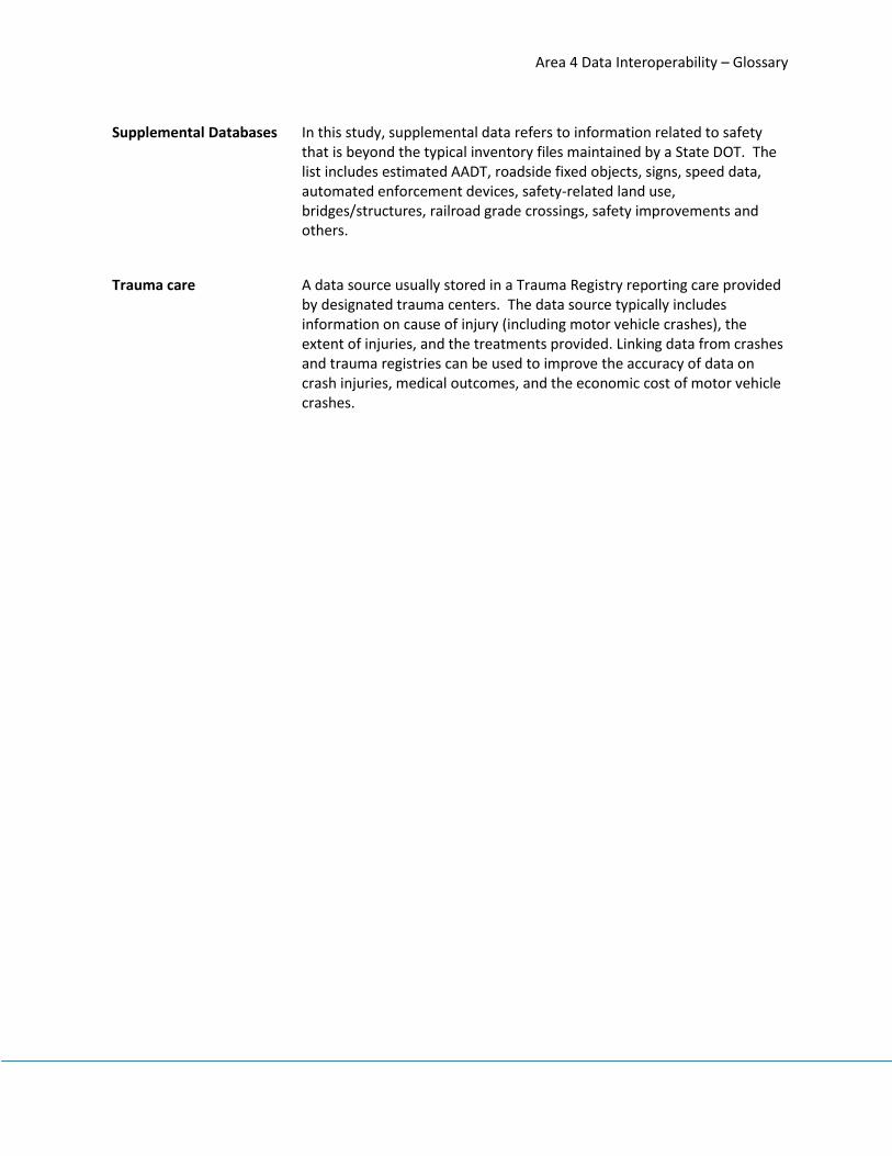
Area 4 Data Interoperability – Glossary
53
Supplemental Databases
In this study, supplemental data refers to information related to safety that is beyond the typical inventory files maintained by a State DOT. The list includes estimated AADT, roadside fixed objects, signs, speed data, automated enforcement devices, safety-related land use, bridges/structures, railroad grade crossings, safety improvements and others.
Trauma care
A data source usually stored in a Trauma Registry reporting care provided by designated trauma centers. The data source typically includes information on cause of injury (including motor vehicle crashes), the extent of injuries, and the treatments provided. Linking data from crashes and trauma registries can be used to improve the accuracy of data on crash injuries, medical outcomes, and the economic cost of motor vehicle crashes.

Post-Assessinar Follow-Up Questions
54
POST-ASSESSINAR FOLLOW-UP QUESTIONS
1. Do you agree that the level assigned to your State is consistent with your ability?
2. To what level would you assign your State (overall and for each Area) if the questions
represented your routine practices rather than absolute ability?
a. Overall:
b. Roadway Data Collection/Technical Standards:
c. Data Analysis Tools and Uses:
d. Data Management and Governance:
e. Data Interoperability and Expandability:
3. What level would you like to be at overall and for each area?
Overall:
Roadway Data Collection/Technical Standards:
Data Analysis Tools and Uses:
Data Management and Governance:
Data Interoperability and Expandability:
4. What are the challenges/barriers preventing you from reaching that level?
5. What kinds of assistance should FHWA be providing to stakeholders to assist with the collection,
use, and expansion of roadway safety data and data capabilities?
6. What kinds of problems are you having with policies or processes at the State or Federal level
that make it difficult to collect, use or expand roadway safety data and data capabilities?
7. What non-financial resources such as tools, guidance, training etc., would be beneficial to you to
collect, use, or expand roadway safety data and data capabilities?

Post-Assessinar Follow-Up Questions
55
8. Is there anything else you would like to share with FHWA, or the highway safety community that
you think would be beneficial to improving the collection, usage, or expansion of roadway safety
data and data capabilities?

Appendix B: MIRE Worksheet
56
APPENDIX A: MIRE ELEMENT WORKSHEET
MIRE Element Collected Indicate the Inventory/Database
it is stored in Comments
State Local
I. Roadway Segment Descriptors
I.a. Segment Location/Linkage Elements
1 County Name (HPMS FE) X Transportation Data Management System
(TDMS) - Roadway file
2 County Code (HPMS FE) X TDMS - Roadway file
3 Highway District
4 Type of Governmental Ownership (HPMS FE) X TDMS - Roadway file
5 Specific Governmental Ownership
6 City/Local Jurisdiction Name X TDMS - Roadway file
7 City/Local Jurisdiction Urban Code X TDMS - Roadway file
8 Route Number (HPMS FE) X TDMS - Roadway file
9 Route/Street Name (HPMS FE) X TDMS - Roadway file
10 Begin Point Segment Descriptor (HPMS FE) X TDMS - Roadway file
11 End point Segment Descriptors (HPMS FE) X TDMS - Roadway file
12 Segment Identifier (HPMS FE) X TDMS - Roadway file
13 Segment Length (HPMS FE) X TDMS - Roadway file
14 Route Signing (HPMS FE) X TDMS - Roadway file
15 Route Signing Qualifier (HPMS FE) X TDMS - Roadway file
16 Coinciding Route Indicator
17 Coinciding Route – Minor Route Information
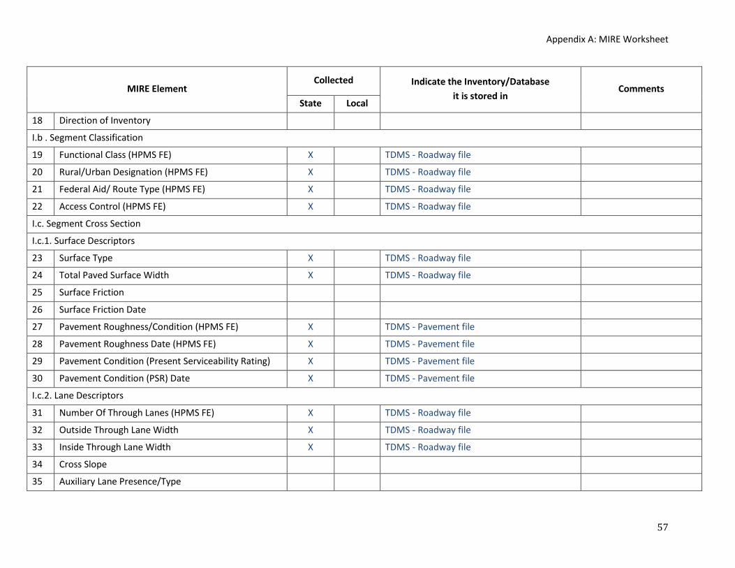
Appendix A: MIRE Worksheet
57
MIRE Element Collected Indicate the Inventory/Database
it is stored in Comments
State Local
18 Direction of Inventory
I.b . Segment Classification
19 Functional Class (HPMS FE) X TDMS - Roadway file
20 Rural/Urban Designation (HPMS FE) X TDMS - Roadway file
21 Federal Aid/ Route Type (HPMS FE) X TDMS - Roadway file
22 Access Control (HPMS FE) X TDMS - Roadway file
I.c. Segment Cross Section
I.c.1. Surface Descriptors
23 Surface Type X TDMS - Roadway file
24 Total Paved Surface Width X TDMS - Roadway file
25 Surface Friction
26 Surface Friction Date
27 Pavement Roughness/Condition (HPMS FE) X TDMS - Pavement file
28 Pavement Roughness Date (HPMS FE) X TDMS - Pavement file
29 Pavement Condition (Present Serviceability Rating) X TDMS - Pavement file
30 Pavement Condition (PSR) Date X TDMS - Pavement file
I.c.2. Lane Descriptors
31 Number Of Through Lanes (HPMS FE) X TDMS - Roadway file
32 Outside Through Lane Width X TDMS - Roadway file
33 Inside Through Lane Width X TDMS - Roadway file
34 Cross Slope
35 Auxiliary Lane Presence/Type

Appendix A: MIRE Worksheet
58
MIRE Element Collected Indicate the Inventory/Database
it is stored in Comments
State Local
36 Auxiliary Lane Length
37 HOV Lane Presence/Type (HPMS FE) X TDMS - Roadway file
38 HOV Lanes (HPMS FE) X TDMS - Roadway file
39 Reversible Lanes
40 Presence/Type of Bicycle Facility
41 Width of Bicycle Facility
42 Number of Peak Period Through Lanes
I.c.3. Shoulder Descriptors
43 Right Shoulder Type X TDMS - Roadway file
44 Right Shoulder Total Width X TDMS - Roadway file
45 Right Paved Shoulder Width
46 Right Shoulder Rumble Strip Presence/Type
47 Left Shoulder Type X TDMS - Roadway file
48 Left Shoulder Total Width X TDMS - Roadway file
49 Left Paved Shoulder Width
50 Left Shoulder Rumble Strip Presence/Type
51 Sidewalk Presence
52 Curb Presence
53 Curb Type
I.c.4. Median Descriptors
54 Median Type X TDMS - Roadway file
55 Median Width X TDMS - Roadway file

Appendix A: MIRE Worksheet
59
MIRE Element Collected Indicate the Inventory/Database
it is stored in Comments
State Local
56 Median Barrier Presence/Type
57 Median (Inner) Paved Shoulder Width
58 Median Shoulder Rumble Strip Presence/Type X TDMS - Roadway file
59 Median Sideslope
60 Median Sideslope Width
61 Median Crossover/Left Turn Lane Type
I.d. Segment Roadside Descriptors
62 Roadside Clearzone Width
63 Right Sideslope
64 Right Sideslope Width
65 Left Sideslope
66 Left Sideslope Width
67 Roadside Rating
68 Major Commercial Driveway Count
69 Minor Commercial Driveway Count
70 Major Residential Driveway Count
71 Minor Residential Driveway Count
72 Major Industrial/Institutional Driveway Count
73 Minor Industrial/Institutional Driveway Count
74 Other Driveway Count
I.e. Other Segment Descriptors
75 Terrain Type

Appendix A: MIRE Worksheet
60
MIRE Element Collected Indicate the Inventory/Database
it is stored in Comments
State Local
76 Number of Signalized Intersections in Segment
77 Number of Stop-Controlled Intersections in Segment
78 Number of Uncontrolled/Other Intersections in
Segment
I.f. Segment Traffic Flow Data
79 Annual Average Daily Traffic (AADT) (HPMS FE) X TDMS - Roadway file
80 AADT Year (HPMS FE) X TDMS - Roadway file
81 AADT Annual Escalation Percentage
82 Percent Single Unit Trucks or Single Truck AADT
(HPMS FE) X TDMS - Roadway file
83 Percent Combination Trucks or Combination Truck
AADT (HPMS FE) X TDMS - Roadway file
84 Percentage Trucks or Truck AADT
85 Total Daily Two-Way Pedestrian Count/Exposure
86 Bicycle Count/Exposure
87 Motorcycle Count or Percentage (HPMS FE)
88 Hourly Traffic Volumes (or Peak and Offpeak AADT)
89 K-Factor
90 Directional Factor
I.g. Segment Traffic Operations/Control Data
91 One/Two-Way Operations (HPMS FE) X TDMS - Roadway file
92 Speed Limit X TDMS - Roadway file

Appendix A: MIRE Worksheet
61
MIRE Element Collected Indicate the Inventory/Database
it is stored in Comments
State Local
93 Truck Speed Limit
94 Nighttime Speed Limit
95 85th Percentile Speed
96 Mean Speed
97 School Zone Indicator
98 On-Street Parking Presence
99 On-Street Parking Type
100 Roadway Lighting
101 Toll Facility (HPMS FE) X TDMS - Roadway file
102 Edgeline Presence/Width
103 Centerline Presence/Width
104 Centerline Rumble Strip Presence/Type X TDMS - Roadway file
105 Passing Zone Percentage
I.h. Other Supplemental Segment Descriptors
106 Bridge Numbers for Bridges in Segment
II. Roadway Alignment Descriptors
II.a. Horizontal Curve Data
107 Curve Identifiers and Linkage Elements
108 Curve Feature Type
109 Horizontal Curve Degree or Radius
110 Horizontal Curve Length
111 Curve Superelevation

Appendix A: MIRE Worksheet
62
MIRE Element Collected Indicate the Inventory/Database
it is stored in Comments
State Local
112 Horizontal Transition/Spiral Curve Presence
113 Horizontal Curve Intersection/Deflection Angle
114 Horizontal Curve Direction
II.b. Vertical Grade Data
115 Grade Identifiers and Linkage Elements
116 Vertical Alignment Feature Type
117 Percent Of Gradient
118 Grade Length
119 Vertical Curve Length
III. Roadway Junction Descriptors
III.a. At-grade Intersection/Junctions
General Descriptors
120 Unique Junction Identifier X TDMS - Intersection file
121 Type of Intersection/Junction
122 Location Identifier for Road 1 Crossing Point X TDMS - Intersection file
123 Location Identifier for Road 2 Crossing Point X TDMS - Intersection file
124 Location Identifier for Additional Road Crossing
Points
125 Intersection/Junction Number Of Legs X TDMS - Intersection file
126 Intersection/Junction Geometry X TDMS - Intersection file
127 School Zone Indicator
128 Railroad Crossing Number

Appendix A: MIRE Worksheet
63
MIRE Element Collected Indicate the Inventory/Database
it is stored in Comments
State Local
129 Intersecting Angle
130 Intersection/Junction Offset Distance
131 Intersection/Junction Traffic Control X TDMS - Intersection file
132 Signalization Presence/Type
133 Intersection/Junction Lighting X TDMS - Intersection file
134 Circular Intersection - Number of Circulatory Lanes
135 Circular Intersection - Circulatory Lane Width
136 Circular Intersection - Inscribed Diameter
137 Circular Intersection - Bicycle Facility
Approach Descriptors (Each Approach)
138 Intersection Identifier for this Approach
139 Unique Approach Identifier
140 Approach AADT
141 Approach AADT Year
142 Approach Mode
143 Approach Directional Flow
144 Number Of Approach Through Lanes X TDMS - Intersection file
145 Left Turn Lane Type
146 Number of Exclusive Left Turn Lanes X TDMS - Intersection file
147 Amount of Left Turn Lane Offset
148 Right Turn Channelization
149 Traffic Control of Exclusive Right Turn Lanes

Appendix A: MIRE Worksheet
64
MIRE Element Collected Indicate the Inventory/Database
it is stored in Comments
State Local
150 Number of Exclusive Right Turn Lanes X TDMS - Intersection file
151 Length of Exclusive Left Turn Lanes
152 Length of Exclusive Right Turn Lanes
153 Median Type at Intersection
154 Approach Traffic Control
155 Approach Left Turn Protection
156 Signal Progression
157 Crosswalk Presence/Type X TDMS - Intersection file
158 Pedestrian Signalization Type
159 Pedestrian Signal Special Features
160 Crossing Pedestrian Count/Exposure
161 Left/Right Turn Prohibitions X TDMS - Intersection file
162 Right Turn-On-Red Prohibitions X TDMS - Intersection file
163 Left Turn Counts/Percent
164 Year of Left Turn Counts/Percent
165 Right Turn Counts/Percent
166 Year of Right Turn Counts/Percent
167 Transverse Rumble Strip Presence
168 Circular Intersection - Entry Width
169 Circular Intersection - Number of Entry lanes
170 Circular Intersection – Presence/Type of Exclusive
Right Turn Lane

Appendix A: MIRE Worksheet
65
MIRE Element Collected Indicate the Inventory/Database
it is stored in Comments
State Local
171 Circular Intersection - Entry Radius
172 Circular Intersection - Exit Width
173 Circular Intersection - Number of Exit Lanes
174 Circular Intersection - Exit Radius
175 Circular Intersection - Pedestrian Facility
176 Circular Intersection - Crosswalk Location
177 Circular Intersection – Island Width
III.b. Interchange and Ramp Descriptors
178 Unique Interchange Identifier X TDMS - Interchange/ramp file
179 Location Identifier for Road 1 Crossing Point X TDMS - Interchange/ramp file
180 Location Identifier for Road 2 Crossing Point X TDMS - Interchange/ramp file
181 Location Identifier for Additional Road Crossing
Points
182 Interchange Type X TDMS - Interchange/ramp file
183 Interchange Lighting
184 Interchange Entering Volume
185 Interchange Identifier for this Ramp
186 Unique Ramp Identifier X TDMS - Interchange/ramp file
187 Ramp Length
188 Ramp Acceleration Lane Length
189 Ramp Deceleration Lane Length
190 Ramp Number of Lanes X TDMS - Interchange/ramp file
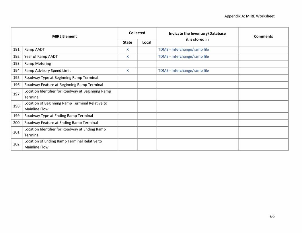
Appendix A: MIRE Worksheet
66
MIRE Element Collected Indicate the Inventory/Database
it is stored in Comments
State Local
191 Ramp AADT X TDMS - Interchange/ramp file
192 Year of Ramp AADT X TDMS - Interchange/ramp file
193 Ramp Metering
194 Ramp Advisory Speed Limit X TDMS - Interchange/ramp file
195 Roadway Type at Beginning Ramp Terminal
196 Roadway Feature at Beginning Ramp Terminal
197 Location Identifier for Roadway at Beginning Ramp
Terminal
198 Location of Beginning Ramp Terminal Relative to
Mainline Flow
199 Roadway Type at Ending Ramp Terminal
200 Roadway Feature at Ending Ramp Terminal
201 Location Identifier for Roadway at Ending Ramp
Terminal
202 Location of Ending Ramp Terminal Relative to
Mainline Flow

STATE DATA CAPABILITIES ASSESSMENT FINAL REPORT
51
APPENDIX C – EXAMPLE STATE CAPABILITY LEVEL

FHWA Roadway Safety Data Partnership
State Roadway Safety Data Capability Assessment Follow-Up
Example State
Fall 2011

RSDP Capabilities Assessment Follow-Up
2
Schedule
TASK STATUS
1. Pre-populate questionnaire Complete
2. Conduct assessment Complete
3. Follow-up with State after assessment In progress
4. Send Roadway Safety Action Plan

RSDP Capabilities Assessment Follow-Up
3
Post-Assessment Feedback
Questions to think about during the assessment review:
Is the assessment consistent with your ability?
What level would you like to be at overall and for each area /element?
What are the challenges/barriers preventing you from reaching that level?
What kinds of assistance should FHWA be providing to assist with data capabilities?
What kinds of problems are you having with policies or processes at the State or Federal level that make it difficult to
collect, use or expand roadway safety data and data capabilities?
What non-financial resources such as tools, guidance, training etc., would be beneficial to you to collect, use, or expand
roadway safety data and data capabilities?
Is there anything else you would like to share with FHWA, or the highway safety community that you think would be
beneficial to improving the collection, usage, or expansion of roadway safety data and data capabilities?

RSDP Capabilities Assessment Follow-Up
4
Overview of Capability Maturity Levels
This assessment process is based on the principles of the “Capability Maturity Model” – CMM. The CMM originated in the
information technology arena to track the development of computer systems. CMMs are now seeing a wider application as a
means for identifying phases of growth and development from a combined qualitative and quantitative perspective. This
approach provides the project team the ability to subjectively assess the States. The principles of the CMM place each State into
“capability categories.” These categories are based on a five-point scale from less to more mature. The five maturity levels used
in this analysis are listed:
Initial / Ad hoc: The organization does not possess a stable implementation environment and the safety data collection,
management (entering/coding, processing, and evaluating) and maintenance process is ‘ad hoc’ with no interconnection
within the organization. Interoperability and expandability are not planned.
Repeatable: Activities are based on the results of previous projects and the demands of the current one. Decisions are
considered during individual projects.
Defined: The process is documented throughout the organization rather than on a per-project basis. Projects are carried
out under guidance of the organization's standards and are tied to an adopted strategy.
Managed: Projects are started and supervised by process management. Through performance management, processes
are predictable and the organization is able to develop rules and conditions regarding the quality of the products and
processes.
Optimizing: The whole organization is focusing on the continuous improvement. The organization possesses the means to
detect weaknesses and to strengthen areas of concern proactively.

RSDP Capabilities Assessment Follow-Up
5
Area 1: Roadway Data Collection/Technical Standards

RSDP Capabilities Assessment Follow-Up
6
Element 1A: Completeness Maturity Level Data Collection (Completeness) Current Level Desired Level
Optimizing (5) The State maintains high-level detail (maximum inventory elements) for all categories (segments, intersections, curves, grades, and interchange/ramps) for all public roads in the State. The inventory files have very few missing or blank fields (i.e., less than 5%).
X
Managed (4) The State maintains high level detail (maximum inventory elements) for all categories (segments, intersections, curves, etc.) for all State-owned roads and moderate level of detail for some categories (segments, intersections, curves, etc.) for some non-State road mileage. The inventory files have very few missing or blank fields (i.e., less than 5%).
Defined (3) The State maintains high-level detail (maximum inventory elements) for at least segments, and for either intersections or curves for all State-owned roads. The inventory files have very few missing or blank fields (i.e., less than 5%).
X
Repeatable (2) The State maintains either a high level of detail on roadway segments or a moderate level detail for roadway segments and at least one other data category (intersections, curves, etc.) for all State-owned roads. The inventory files have no more than a moderate amount of missing or blank fields.
Initial (1) The State maintains low-level of detail (i.e., limited elements) for roadway segments for some or all State-owned roads. No other data categories are maintained (e.g., intersections, curves, etc.) The inventory files have a moderate to large amount of missing or blank fields.
Assessor Notes:
State collects many data elements on all State-maintained roads, but does not collect data on any local roads.
Questions for State:
What are the challenges/barriers preventing you from reaching your desired level?
Lack of resources to collect and maintain local data.
Lack of data sharing agreements with the local agencies.
What kinds of assistance should FHWA be providing to assist with data capabilities?
Funding specifically dedicated for data collection.
Information on the latest data collection technologies and methods.
Education/ “marketing” to decision makers on the importance of data.

RSDP Capabilities Assessment Follow-Up
7
Maturity Level Actions to Increase Levels (Completeness)
Optimizing (5) Continue maintenance of the data collection cycle for all roadways. Continue and/or develop new data quality metrics
Managed (4) Pursue a complete inventory for all public roads by collecting data for local roads and increase the level of detail for all roadways (state and local) to include high level of detail for all roads, not just state-maintained)
Defined (3) Develop a local roads inventory database with at least a moderate level of detail on the local roadways.
Repeatable (2) Reduce the frequency of missing or blank data fields on state-maintained roadways in the inventory to less than 5%. Pursue high level of detail on all segments as well as either intersections or curves on state-maintained roadways.
Initial (1) Ensure that the inventory includes all state-maintained roads. Increase the level of detail to at least the moderate level for segments plus at least one other data category (intersections, curves, etc.). Moderate level would include most of the Fundamental Data Elements.
In general, states have two major concerns to address in developing a complete roadway inventory: coverage of all public roads and a sufficient level of detail for all data categories in the inventory. As a state identifies a deficiency in either area it can achieve a higher maturity level by increasing either the number of roadways included in the inventory, or the number of data elements captured within a broader range of categories (intersections, curves, grades, interchange/ramps, etc.).
Throughout, it is also important to reduce the amount of missing data below a reasonable threshold (5% missing/blank or less in the model).
Ultimately, at the optimal maturity level (level 5), states should ensure that the system does not decay. A cycle of data collection should be established and maintained that effectively adds new roadways (and adjusts records of existing locations). Data quality metrics should be maintained and/or established to ensure completeness.

RSDP Capabilities Assessment Follow-Up
8
Element 1B: Timeliness Maturity Level Data Collection (Timeliness) Current Level Desired Level
Optimizing (5) The State continually updates all roadway inventory files for both new and modified roadways with a process in which descriptions or “as built” plans are submitted to the file maintainer each time a change is made or a new road is opened. The data for the affected section or locations then are updated to the computerized file within one month of completion of the change.
Managed (4) The State continually updates all roadway inventory files for both new and modified roadways with a process in which descriptions or “as built” plans are submitted to the file maintainer each time a change is made or a new road is opened. The data for the affected section or locations then are updated to the computerized file within two - three months of completion of the change.
X X
Defined (3) The State updates the inventory information with an annual (or less often) survey of the entire system (e.g., the roadway system is re-inventoried over a five-year period). The new data are entered into all computerized files within three months of the inventory.
Repeatable (2) The State’s process for updating is based on volunteer reporting by field personnel. This leads to a moderate number of cases where no report is made. For changes reported, the updates made to the computer file normally take six months or longer.
Initial (1) The State has no standardized procedure for updating the inventory files. Changes to the files are only made when they come to the attention of the file maintainer.
Assessor Notes:
Data is continually updated with a time lapse of 3 months or less. Modified data fields indicate the date an inventory
element was updated.
Questions for State:
What are the challenges/barriers preventing you from reaching your desired level?
N/A
What kinds of assistance should FHWA be providing to assist with data capabilities?
N/A

RSDP Capabilities Assessment Follow-Up
9
Maturity Level Actions to Increase Levels (Timeliness)
Optimizing (5) Ensure that the maintenance cycle for data is continuous and fully addresses user needs. Continue and/or develop new data quality metrics.
Managed (4) Reduce the amount of time required for submission of as-built plans and/or for updating the database to achieve a goal of one month from completion of the roadway change.
Defined (3) Move from annual review to continuous updating. Require submittal of as-built plans in a timely manner.
Repeatable (2) Ensure that all changes are reviewed and reported at least annually. Ensure that roadway changes are reflected in the database within three months after completion of the annual review.
Initial (1) Develop a standard method for updating roadway inventory files. Develop a voluntary notification method so that the field can alert the inventory file maintainer of changes.
States have many options for processes to document changes in the roadway network. To improve from a baseline of ad-hoc updates based on the file maintainers noticing a change, some states rely on voluntary, informal notification from the field (the DOT districts and or local engineers at the municipal, county, or MPO level). Many states have implemented a more formal, periodic (usually annual) review of the entire roadway network state and local staff. These annual reviews typically generate a number of adjustments to the state DOT roadway databases, often requiring several months’ effort to complete. A more frequent update process, requiring field staff and local engineers to provide information to the state upon completion of any roadway change is clearly optimal. The top level of performance is achieved if the state file maintainers are able to complete their updates shortly after the completion of the change in the roadway. In an ideal situation, users’ needs would determine how soon after a roadway change the information should be available in the state DOT databases—the value of “one month” for level 5 should be modified downward depending on the needs of users. It is assumed that states will have, along the way, developed valid methods of measuring the timeliness of roadway data such that they can both manage their processes and report the level of timeliness achieved.

RSDP Capabilities Assessment Follow-Up
10
Element 1C: Accuracy Maturity Level Data Collection (Accuracy) Current Level Desired Level
Optimizing (5) The State has a high level of accuracy in their inventory data across all categories that they maintain (segments, intersections, curves, etc.). The existing values are very accurate as determined by a frequent systematic external verification process involving field data collection (e.g., surveys, field visits, and aerial photos). The State has developed and uses a computerized set of internal verification checks for data reasonableness.
X
Managed (4) The State has a moderate to high level of accuracy in their inventory data across all categories that they maintain (segments, intersections, curves, etc.). The level of existing accuracy is verified by infrequent external verification with field data collection. The State also has developed and uses a computerized set of internal verification checks for data reasonableness.
X
Defined (3) The State has a moderate level of accuracy in their inventory data across all categories that they maintain (segments, intersections, curves, etc.). The data are believed to be moderately accurate, but the State does not conduct any kind of external verification process. The State also has developed and uses a computerized set of internal verification checks for data reasonableness.
Repeatable (2) The State has some subjective judgment of accuracy indicating a moderate level of accuracy across all categories that they maintain (segments, intersections, curves, etc.). The measure of accuracy is generally judgment based on maintainer/user familiarity with the data. There is no external verification with field data collection and no internal verification with checks for reasonableness.
Initial (1) The State has no measure of the accuracy of their inventory data and the accuracy of the data is felt to be low. There is no external verification with field data and no internal verification with checks for reasonableness.
Assessor Notes:
Aerial photos used to verify data on a 5-year cycle. Most (70%) of the fields are checked for logical errors.
Questions for State:
What are the challenges/barriers preventing you from reaching your desired level?
No perceived barriers.
What kinds of assistance should FHWA be providing to assist with data capabilities?
More information on performance measures for roadway data.

RSDP Capabilities Assessment Follow-Up
11
Maturity Level Actions to Increase Levels (Accuracy)
Optimizing (5) Ensure that the external verification process cycle is maintained and expanded where necessary to meet users’ needs for validated accuracy levels.
Managed (4) Increase the frequency and breadth of external verifications such that more data elements are validated more often based on data collected in the field.
Defined (3) Establish external verification processes to compare the data in the database against data collected via field observations.
Repeatable (2) Develop some measures of accuracy. At a minimum, the State should develop a set of internal verification checks that compare data among many fields to ensure logical consistency.
Initial (1) Develop some measures of accuracy. At this point, it is not recommended that a state strive to achieve Level 2, as it is only marginally better than level 1. States should attempt to attain at least level 3 by developing internal validity checks for logical agreement among data fields.
The measurement of accuracy includes checks of internal validity (logical agreement among data fields—do the data “make sense?”) as well as the more costly and time-consuming external validity checks comparing database entries to actual field data. It is likely that states will have an easier time developing the checks for internal validity, but to achieve the optimal level of performance, both types of checks are needed.

RSDP Capabilities Assessment Follow-Up
12
Element 1D: Uniformity/Consistency Maturity Level Data Collection (Uniformity/Consistency) Current Level Desired Level
Optimizing (5) The State has a high level of uniformity and consistency in element definitions and codes. Data coding is consistent across all State and non-State files. Procedures are in place to ensure that coding is consistent across multiple years and to ensure that particular locations on roadways can be tracked across multiple years.
Managed (4) The State has a moderate to high level of uniformity and consistency. Data coding is consistent across all State files but not non-State files. Procedures are in place to ensure that coding is consistent for all elements across multiple years and to ensure that particular locations on roadways can be tracked across multiple years.
X
Defined (3) The State has a moderate level of uniformity and consistency. Data coding is consistent across all State files but not non-State files. While procedures are in place to ensure that particular locations on roadways can be tracked across multiple years, procedures are not in place to ensure that coding for all elements is consistent across multiple years.
X
Repeatable (2) The State has a moderate level of uniformity and consistency. Data coding is consistent across all State files but not non-State files. Procedures are in place to ensure that coding for most elements is consistent across multiple years, but procedures are not in place to ensure that particular locations on roadways can be tracked across multiple years.
Initial (1) The State has a low level of uniformity and consistency. Data coding is not consistent across all State files or non-State files. There are no procedures are in place to ensure that coding is consistent across multiple years or to ensure that particular locations on roadways can be tracked across multiple years.
Assessor Notes:
Consistent coding across all State roads. No procedures in place to ensure the site address is the same across multiple
years.
Questions for State:
What are the challenges/barriers preventing you from reaching your desired level?
Currently undergoing an effort to improve uniformity/consistency.
What kinds of assistance should FHWA be providing to assist with data capabilities?
No additional comments.

RSDP Capabilities Assessment Follow-Up
13
Maturity Level Actions to Increase Levels (Uniformity/Consistency)
Optimizing (5) Ensure that updates to the data collection forms and/or the database are reflected in standard data collection protocols and instruction manuals.
Managed (4) Ensure that data coding is consistent for all public roadways (not just state-maintained roadways).
Defined (3) Develop procedures to ensure that data elements are coded consistently across multiple years.
Repeatable (2) Develop procedures for tracking roadway locations across multiple years in the database.
Initial (1) Develop data coding standards and share them with all who submit or enter data. Conduct validation checks to assess uniformity/consistency across years.
States can ensure uniformity and consistency of roadway data by developing measurements of uniformity/consistency and supplying data collectors/coders with explicit guidance in the form of data dictionaries, instruction manuals, training, edit checks, and feedback based on periodic analysis of the data. As states move up the levels from level 1 (ad-hoc) to level 5 (optimizing), it is expected that they will develop procedures for tracking uniformity/consistency as well as metrics that measure the level of uniformity achieved. Where relevant, these metrics should be reportable at a level of specificity sufficient to identify particular data submission sources (agencies, portions of the DOT) that are having difficulties adhering to the established standards. Feedback at a general level is also useful, but a system that fails to identify specific sources of inconsistency will present difficulties for those trying to address the problems.

RSDP Capabilities Assessment Follow-Up
14
Area 2: Data Analysis Tools and Uses

RSDP Capabilities Assessment Follow-Up
15
Element 2A: Network Screening
Element 2A: Network Screening (Data)
Maturity Level Network Screening (Data) Current Level Desired Level
Optimizing (5) System Plus Analysis – based on roadway inventory data (e.g., ability to screen all curves or intersections of a certain type to determine sites with most promise), incorporating traffic volume data, and crash data along with citation, driver, or injury outcome data.
X
Managed (4) System Analysis – based on roadway inventory data (e.g., ability to screen all curves or intersections of a certain type to determine sites with most promise), incorporating traffic volume data and crash data (e.g., use of SafetyAnalyst).
Defined (3) Crash-Based Plus – based on crash data with traffic or roadway inventory linked. Difficult to identify “zero-crash” locations. X
Repeatable (2) Crash-Based – based on crash data only (or fatal crash only). Does not link traffic or roadway inventory data. Initial (1) Solicited Input – severe lack of crash data. Must rely on input from district/county/local staff or citizen
complaints to identify sites for improvement.
Assessor Notes:
Network screening based on crash data.
Crash, roadway, and traffic data available for network screening process.
Questions for State:
What are the challenges/barriers preventing you from reaching your desired level?
Lack of resources to collected desired data.
What kinds of assistance should FHWA be providing to assist with data capabilities?
Tools for estimating traffic volumes on low volume/local roads.

RSDP Capabilities Assessment Follow-Up
16
Maturity Level Actions to Increase Levels (Data)
Optimizing (5) Ensure ongoing availability and use of linked data from multiple traffic records data sources.
Managed (4) Develop additional linkages between crash and other relevant traffic records databases (citation, driver, vehicle, injury surveillance, etc.)
Defined (3) Ensure linkage of crashes with both traffic and roadway inventory data. Ensure sufficient linked database coverage to include locations with zero crash frequency.
Repeatable (2) If only fatal crash data are used, work to ensure that data at all levels of crash severity are obtained and used. Develop linkages between crash and roadway data (traffic and inventory).
Initial (1) Work to obtain sufficient crash data to support safety analysis. The data should include all levels of severity and cover all public roads.
In an optimal system, analysts have access to multiple linked data resources exploiting linking opportunities among crash, traffic, detailed roadway inventory, citation, driver, vehicle, and injury surveillance system data. These linked data serve as a resource to enhance and correct the component sources (for example, the injury surveillance data provide a more accurate picture of crash consequences than the crash data alone). States that lack data, or use only a portion of the data for network screening should work towards a fully linked traffic records system by ensuring that the crash data are complete, that they link well with a complete roadway inventory (covering all public roads) and relevant traffic count data. States that achieve this level of linkage (levels 3 and 4) should strive to incorporate more linked data into their analyses in order to develop a more detailed picture of the crash experience in their state.

RSDP Capabilities Assessment Follow-Up
17
Element 2A: Network Screening (Method) Maturity Level Network Screening (Method) Current Level Desired Level
Optimizing (5) Advanced Methods – ability to employ state-of-the-art methods for network screening. Accounts for regression-to-the-mean, exposure, and sets a performance threshold (e.g., uses an SPF to determine the “expected” level of safety). Compares the relative safety of sites with similar characteristics (i.e., need to be able to identify specific groups of sites for screening).
X
Managed (4) Traditional Methods Plus – ability to use traditional screening tools such as crash rate or crash severity indices. Accounts for mean exposure and sets a performance threshold. Does not account for regression-to-the-mean and is misled by the non-linearity of rate (crash and traffic volume).
Defined (3) Traditional Methods– ability to use traditional screening tools such as crash rate or crash severity indices. Accounts for mean exposure. Does not set a performance threshold or account for regression-to-the-mean and is misled by the non-linearity of rate (crash and traffic volume).
Repeatable (2) Simple Methods – ability to use traditional screening tools such as crash frequency, crash rate, or crash severity indices. Does not account for regression-to-the-mean and does not set a performance threshold. X
Initial (1) Judgment – relies solely on input and judgment of State and local transportation staff.
Assessor Notes:
The State can identify almost all networks in the network screening process; however they only use simple analysis
methods.
Questions for State:
What are the challenges/barriers preventing you from reaching your desired level?
Knowledge on more advanced safety analysis methods; currently working on applying the HSM.
What kinds of assistance should FHWA be providing to assist with data capabilities?
More training for some of the new analysis tools – HSM, SafetyAnalyst.

RSDP Capabilities Assessment Follow-Up
18
Maturity Level Actions to Increase Levels (Method)
Optimizing (5) Ensure that the state validates and calibrates modern methods of network screening for local (state) use. Ensure currency with evolving methods by staying up-to-date with new releases of analytic tools, processes, and methodologies.
Managed (4) Adoption of optimal methods is recommended. Traditional methods are prone to error and require similar levels of data as the optimal methods. The level of analytic capabilities required to adopt optimal methods is higher than for traditional methods, but the payoff in improved validity leads to their recommendation as superior.
Defined (3) Adoption of optimal methods is recommended. Traditional methods are prone to error and require similar levels of data as the optimal methods. The level of analytic capabilities required to adopt the optimal methods is higher than for traditional methods, but the payoff in improved validity leads to their recommendation as superior. At this point, it is not recommended that a state strive to achieve Level 4, as these levels are only marginally better than level 2 or 3. States should attempt to attain level 5 by adopting optimal screening methods.
Repeatable (2) Adoption of optimal methods is recommended. Traditional methods are prone to error and require similar levels of data as the optimal methods. The level of analytic capabilities required to adopt the optimal methods is higher than for traditional methods, but the payoff in improved validity leads to their recommendation as superior. At this point, it is not recommended that a state strive to achieve Level 3, or 4, as these levels are only marginally better than level 2. States should attempt to attain level 5 by adopting optimal screening methods.
Initial (1) Adoption of optimal methods is recommended. Traditional methods are prone to error and require similar levels of data as the optimal methods. The level of analytic capabilities required to adopt the optimal methods is higher than for traditional methods, but the payoff in improved validity leads to their recommendation as superior.
Traditional methods, as represented by Levels 1-4, do not support the same level of certainty and analytic validity as the state of the art methods as presented in the Highway Safety Manual and elsewhere. States that have not yet achieved level 5 should strive to attain that level. Incremental improvements to a “traditional” method are valid and can add value; however they do not serve the ultimate goal of achieving level 5’s optimum.

RSDP Capabilities Assessment Follow-Up
19
Element 2A: Network Screening (Coverage)
Maturity Level Network Screening (Coverage) Current Level Desired Level
Optimizing (5) Public Plus – ability to include all public roads in the network screening process plus other roadways that are not publicly owned (toll-roads, military bases, Indian reservations, etc).
Managed (4) Public – ability to include all public roads in the network screening process. X X Defined (3) State Plus – ability to include all State-maintained roads in the network screening process plus some non-
State-maintained roads.
Repeatable (2) State – ability to include all State-maintained roads in the network screening process. Initial (1) Less than State – ability to include only a portion of State-maintained roads in the network screening process.
Assessor Notes:
All State-maintained and public roadways are covered. The State does not cover non-public roadways.
Questions for State:
What are the challenges/barriers preventing you from reaching your desired level?
N/A
What kinds of assistance should FHWA be providing to assist with data capabilities?
N/A

RSDP Capabilities Assessment Follow-Up
20
Maturity Level Actions to Increase Levels (Coverage)
Optimizing (5) Ensure ongoing support for inclusion of all accessible trafficways and maintain a common location coding mechanism so that inventory, traffic, and crash data may continue to be linked.
Managed (4) Include non-publicly owned roads (toll roads, military bases, tribal lands, etc) in the roadway inventory, traffic, and crash databases.
Defined (3) Ensure that all public roads are included in the roadway inventory, traffic, and crash databases. This will generally require a means of assigning location codes based on a common standard.
Repeatable (2) Add critical local (non-state-maintained) roads to the databases. Many states that lack full local road coverage in their inventory have added all HPMS sample segments to their roadway inventory, for example.
Initial (1) Identify gaps in the current databases and enhance the systems to include all state-maintained roads.
States have an interest in monitoring the safety of travel on all roadways. The databases used for network screening should support the state’s ability to quantitatively describe the crash experience on all roads by including every roadway type and location. The critical three data systems of roadway inventory, traffic, and crash may each have limitations in coverage. Linkage among these limited data will result in a file that shares the limitations of all the component pieces. The optimal solution is to develop databases for roadway inventory, traffic, and crash data that cover all roadways in the state. In priority order, however, it is clearly most important that all public roadways be included in the databases (level 4). States at or below level 3 should strive develop databases that include all public roads regardless of jurisdiction. A common location coding method applicable to all public roads is essential to ensuring that the databases can be linked efficiently.
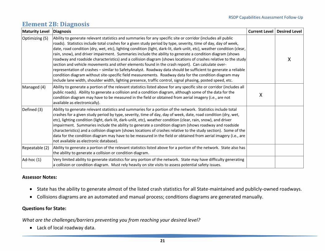
RSDP Capabilities Assessment Follow-Up
21
Element 2B: Diagnosis Maturity Level Diagnosis Current Level Desired Level
Optimizing (5) Ability to generate relevant statistics and summaries for any specific site or corridor (includes all public roads). Statistics include total crashes for a given study period by type, severity, time of day, day of week, date, road condition (dry, wet, etc), lighting condition (light, dark-lit, dark-unlit, etc), weather condition (clear, rain, snow), and driver impairment. Summaries include the ability to generate a condition diagram (shows roadway and roadside characteristics) and a collision diagram (shows locations of crashes relative to the study section and vehicle movements and other elements found in the crash report). Can calculate over-representation of crashes – similar to SafetyAnalyst. Roadway data should be sufficient to generate a reliable condition diagram without site-specific field measurements. Roadway data for the condition diagram may include lane width, shoulder width, lighting presence, traffic control, signal phasing, posted speed, etc.
X
Managed (4) Ability to generate a portion of the relevant statistics listed above for any specific site or corridor (includes all public roads). Ability to generate a collision and a condition diagram, although some of the data for the condition diagram may have to be measured in the field or obtained from aerial imagery (i.e., are not available as electronically).
X
Defined (3) Ability to generate relevant statistics and summaries for a portion of the network. Statistics include total crashes for a given study period by type, severity, time of day, day of week, date, road condition (dry, wet, etc), lighting condition (light, dark-lit, dark-unlit, etc), weather condition (clear, rain, snow), and driver impairment. Summaries include the ability to generate a condition diagram (shows roadway and roadside characteristics) and a collision diagram (shows locations of crashes relative to the study section). Some of the data for the condition diagram may have to be measured in the field or obtained from aerial imagery (i.e., are not available as electronic database).
Repeatable (2) Ability to generate a portion of the relevant statistics listed above for a portion of the network. State also has the ability to generate a collision or condition diagram.
Ad-hoc (1) Very limited ability to generate statistics for any portion of the network. State may have difficulty generating a collision or condition diagram. Must rely heavily on site visits to assess potential safety issues.
Assessor Notes:
State has the ability to generate almost of the listed crash statistics for all State-maintained and publicly-owned roadways.
Collisions diagrams are an automated and manual process; conditions diagrams are generated manually.
Questions for State:
What are the challenges/barriers preventing you from reaching your desired level?
Lack of local roadway data.
RSDP Capabilities Assessment Follow-Up
22
Do not have fully automated process for developing collision and condition diagrams. This will come later on if we can
start collected local roadway data and incorporating it into our system.
What kinds of assistance should FHWA be providing to assist with data capabilities?
See previous comments on assistance in collecting local roadway data.
Maturity Level Actions to Increase Levels (Diagnosis)
Optimizing (5) Ensure that detailed data on roadway features/attributes are maintained on a sufficient schedule to meet users’ needs.
Managed (4) Develop feature-specific reports of over-representation in crashes.
Enhance the roadway data to support generation of condition diagrams solely from database contents.
Defined (3) Develop reports for all public roadways.
Repeatable (2) Develop comprehensive summary reports describing site-specific crash experience.
Ensure that both collision and condition diagrams can be generated for any site of interest.
Ad-hoc (1) Develop analytic reports to summarize crash experience at specific sites of interest.
Data-based diagnosis of safety issues can be done on a macro- and micro-level. At the macro level, states can generally perform aggregate analyses for all roadways and for roadways grouped by descriptive attributes (roadway type, usage, specific features present, etc.). At the micro level, states have the further ability to associate crash experience with particular roadway features and attributes and to develop estimates of expected crash frequencies associated with the presence of various features or attributes.
As states increase the sophistication of their diagnostic analyses, data to support those analyses will be needed in a readily accessible form, preferably a linked database of crash, roadway inventory, traffic count, and other data. The roadway datasets will ideally include all necessary information, sufficiently up-to-date and detailed, such that it supports collision and condition diagramming at a work station rather than requiring a field visit.
The data needs shift as one advances in maturity levels. In general, moving from Level 1 to Level 3, requires having a robust and current roadway inventory where all classes of roadway are diagnosed to be successful. Success in Level 4 and 5 relies on having current data on specific features of the roadway. At the highest level, maintenance of the system’s capabilities and a guaranteed refresh-cycle of data is paramount. Data need to be continuously updated to retain a high level in the Diagnosis element.

RSDP Capabilities Assessment Follow-Up
23
Element 2C: Countermeasure Selection Maturity Level Countermeasure Selection Current Level Desired Level
Optimizing (5) State has the ability to determine all existing safety-related infrastructure attributes for any specific site or corridor (includes all public roads) without a site visit. Includes complete roadway data for intersections, curves, tangents, interchanges, and at-grade rail crossings. Also includes peripheral safety databases such as sign inventory, lighting presence and condition, pavement condition, presence and condition of pavement markings, etc.
Managed (4) State has the ability to determine a portion of the existing safety-related infrastructure attributes for any specific site or corridor (includes all public roads). May require a site visit or use of aerial imagery to determine certain attributes.
X
Defined (3) State has the ability to determine all existing safety-related infrastructure attributes for a portion of the network. Includes peripheral safety databases such as sign inventory, lighting presence and condition, pavement condition, presence and condition of pavement markings, etc. for that portion of the network.
X
Repeatable (2) State has the ability to determine a portion of the existing safety-related infrastructure attributes for a portion of the network. May require a site visit or use of aerial imagery to determine certain attributes.
Initial (1) Very limited ability to determine existing safety-related infrastructure attributes for any portion of the network. Must rely heavily on site visits to assess potential safety issues.
Assessor Notes:
State has roadway data for all State-maintained roads including a few other databases.
Questions for State:
What are the challenges/barriers preventing you from reaching your desired level?
Don’t have local roadway data (see previous comments).
Also would need more data on State-maintained roadways to increase our capabilities.
What kinds of assistance should FHWA be providing to assist with data capabilities?
Nothing additional.

RSDP Capabilities Assessment Follow-Up
24
Maturity Level Actions to Increase Levels (Countermeasure Selection)
Optimizing (5) Maintain the data on roadway safety-related infrastructure attributes on a cycle that meets the needs of users.
Managed (4) Include all public roads in the inventory at the same high level of detailed safety-related infrastructure attributes.
Defined (3) Include all public roads in the inventory at the same high level of detailed safety-related infrastructure attributes.
Repeatable (2) Enhance the roadway inventory to include a full data element list of all safety-related infrastructure attributes.
Initial (1) Develop/enhance the roadway inventory database to expand coverage of the network and features (safety-related infrastructure).
As states increase the sophistication of their countermeasure selection analyses, data to support those analyses will be needed in a readily accessible form, preferably to include detailed data elements describing safety-related infrastructure attributes of the roadway and peripheral database information such as signs, lighting, pavement condition and markings, etc. The roadway datasets will ideally include all necessary information, sufficiently up-to-date and detailed, such that it supports countermeasure selection or design analysis at a work station rather than requiring a field visit. The data needs shift as one advances in maturity levels. Since countermeasure selection relies heavily on the diagnosis element, moving from Level 1 to Level 3, requires having a robust and current roadway inventory where all classes of roadway are diagnosed to be successful. Success in Level 4 and 5 relies on having current data on specific features of the roadway. States at levels 3 or 4 should move directly to level 5. At the highest level, maintenance of the system’s capabilities and a guaranteed refresh-cycle of data is paramount. Data need to be continuously updated to retain a high level in the Diagnosis element.

RSDP Capabilities Assessment Follow-Up
25
Element 2D: Evaluation Element 2D: Evaluation Maturity Level Evaluation Current Level Desired Level
Optimizing (5) Project Level: Ability to conduct a rigorous before-after project-level evaluation, accounting for regression-to-the-mean, traffic volume trends, and temporal trends (i.e., changes over time other than the treatment or project of interest). State has the ability to perform this type of evaluation for any project (i.e., requires data on all roads in the State). This type of evaluation is carried out by applying the empirical Bayes before-after observational study. Requires installation data and 5+ years of historical crash and respective annual traffic volume data for treatment and non-treatment sites, and will develop SPFs for the evaluation study. Program Level: Ability to evaluate the effectiveness of specific programs, including the cost and potential benefit. Requires project level data to identify the number of projects by type (so projects can be associated with a specific program), the cost of projects by type, and the relative timeframe of installation. Also requires crash data on a statewide basis with information on specific crash types and contributing factors. Exposure data (e.g., VMT) are available to account for changes over time and 5+ years of crash data are available to account for other time trends.
Managed (4) Project Level: Ability to conduct a rigorous before-after project-level evaluation, accounting for regression-to-the-mean, traffic volume trends, and temporal trends (i.e., changes over time other than the treatment or project of interest). State has the ability to perform this type of evaluation for some projects (i.e., requires data on a subset of roads in the state). This type of evaluation is carried out by applying the empirical Bayes before-after observational study. Requires installation data and 5+ years of historical crash and respective annual traffic volume data for treatment and non-treatment sites, and will develop SPFs for the evaluation study. Program Level: Ability to evaluate the effectiveness of specific programs, including the cost and potential benefit. Requires project level data to identify the number of projects by type (so projects can be associated with a specific program), the cost of projects by type, and the relative timeframe of installation. Also requires crash data on a statewide basis with information on specific crash types and contributing factors. One of the following is also available: 1. Exposure data (e.g., VMT) are available to account for changes over time. 2. 5+ years of crash data are available to account for other time trends (5+ years of data helps to establish
trends versus 4 or fewer years).
X X

RSDP Capabilities Assessment Follow-Up
26
Defined (3) Project Level: Ability to conduct cross-sectional project-level evaluations. The State has crash, traffic volume, and roadway data for specific projects. An empirical Bayes analysis is not possible because either the State does not track the specific installation date OR there are fewer than 5 years of historical data available for analysis (not enough years to develop stable estimates of expected crashes in the before and after period). Program Level: Project-level data are available, but incomplete. May not include cost data, exposure data, or may not have 5+ years of crash data available for analysis.
Repeatable (2) Project Level: Ability to conduct a simple before-after project-level evaluation. Accounts for traffic volume changes, but does not account for regression-to-the-mean or temporal trends (i.e., changes over time other than the treatment/project of interest). Installation, crash, and traffic volume data are available for the treatment site(s) of interest, but not for a reference/comparison group (i.e., non-treatment sites). Program Level: Crash data are available for at least all State-maintained roads to evaluate the overall performance of the State, but not at the project level to determine the effectiveness of a specific program.
Initial (1) Project Level: Ability to conduct a simple before-after or anecdotal project-level evaluation. Does not account for regression-to-the-mean, traffic volume trends, or temporal trends (i.e., changes over time other than the treatment/project of interest). Installation and crash data are available for the treatment site(s) of interest, but not for a reference/comparison group (i.e., non-treatment sites). Program Level: Anecdotal program-level evaluation. Data are not available to support specific program evaluations.
Assessor Notes:
State maintains records for only improvement projects on State roads; no records for local road projects.
The State does not currently employ empirical Bayes methodologies, however, has the data available to do this type of
analysis on State roads.
Questions for State:
What are the challenges/barriers preventing you from reaching your desired level?
N/A
What kinds of assistance should FHWA be providing to assist with data capabilities?
N/A

RSDP Capabilities Assessment Follow-Up
27
Maturity Level Actions to Increase Levels (Evaluation)
Optimizing (5) Ensure that the data refresh cycle is maintained and meets the needs of users. Ensure that the refresh cycle for data is sufficient to meet users’ needs.
Managed (4) Develop a complete inventory and safety-project tracking mechanism for all public roads. Ensure that a 5+ year history is available for all locations in the database. Develop both traffic volume and crash data history for all public roadways.
Defined (3) Ensure that installation dates are tracked for all safety-related countermeasures. Develop a five-year minimum historical database for crashes and traffic volume data. Ideally, the databases would cover all public roads, but could be accomplished by collecting data for a specific subset of roadway locations. Develop methods of analyzing cost/benefit of projects/programs. Ensure that all safety-related programs are tracked by installation date, location, and relevant program. Move toward collection of statewide data for crash and traffic volume. Maintain historical data for at least one of these.
Repeatable (2) Develop a comprehensive dataset to include non-treatment sites as a reference/comparison group. Ideally, this would include data on all public roads, but could be accomplished by collecting evaluation data on selected sites, some of which remain untreated. Develop the ability to track project/program-level outcomes. Ideally, project-level data will include 5+ years of crash data, project implementation dates and cost, and project-specific traffic volume estimates.
Initial (1) Develop datasets supporting analyses that can account for changes in travel volume over time. Develop data resources to support statewide safety evaluation. This should include crash, statewide traffic volume estimates.
As with other Section 2 elements, movement to higher levels centers on addressing data gaps. Data are needed on all public roadways such that analysts can examine the features and attributes of all roadways in order to develop reasonable comparison groups for use in evaluation of project success at treatment sites. In addition, to support state-of-the-art analytic methods (e.g., Empirical Bayes), historical data for at least 5 years are required. States can move from low levels (1-3) to higher levels (4-5) by ensuring that all safety-related countermeasure installation dates are tracked, by building a 5+ year history of crash and traffic volume data, and by ensuring that the databases are sufficiently complete in terms of roadway coverage (all public roads) and data elements (roadway features and attributes are recorded for all locations).
For program evaluation, optimal systems include data on specific projects under each safety-related program. States move up from lower levels (1-2) by ensuring the ability to track individual projects and by maintaining 5+ year histories of crash and traffic volume data.

RSDP Capabilities Assessment Follow-Up
28
Element 2E: Accessibility Maturity Level Accessibility Current Level Desired Level
Optimizing (5) State has a formal process for requesting data and the ability to provide data to all safety partners, including the public, within a defined timeline. X
Managed (4) State has an informal process for requesting data and the ability to provide data to all safety partners. Defined (3) State has a formal process for requesting data and the ability to provide data to some safety partners within a
defined timeline.
Repeatable (2) State has an informal process for requesting data and the ability to provide data to some safety partners. X Initial (1) Few individuals within the DOT are granted access to the data.
Assessor Notes:
Only data managers have direct access to data.
Many safety partners can submit requests for data.
No formal process for requesting data or defined timeline for filling data requests.
Questions for State:
What are the challenges/barriers preventing you from reaching your desired level?
No barriers identified, just have not done anything to increase capabilities – not a priority at the time.
What kinds of assistance should FHWA be providing to assist with data capabilities?
Nothing identified.

RSDP Capabilities Assessment Follow-Up
29
Maturity Level Actions to Increase Levels - Accessibility
Optimizing (5) Ensure that the needs of new/infrequent users are addressed by agency policies and procedures.
Managed (4) Formalize the data request process.
Defined (3) Develop policies and procedures to meet the data needs of all safety partners.
Repeatable (2) Develop data access policies to broaden the list of who may have direct access to the data, and how others may make requests for data. The policies should address any requirements to review requests and collect signatures on release statements.
Initial (1) Develop data access policies to broaden the list of who may have direct access to the data, and how others may make requests for data. The policies should address any requirements to review requests and collect signatures on release statements.
Data access policies and procedures are established by states and agencies to ensure compliance with applicable laws (privacy protection, etc.) while also providing the broadest possible access to data for legitimate uses, including safety improvement. An optimal system is one that has formal policies in place and makes the data available to all safety partners, including the public—within the confines of necessary restrictions. States can move from low levels (1-2) of accessibility by creating policies and procedures for handling data requests (how to make a request, review procedures, limitations on release, signature requirements, timing, etc.) and by ensuring that the data and access methods meet users needs.
RSDP Capabilities Assessment Follow-Up
30
Area 3: Data Management and Governance

RSDP Capabilities Assessment Follow-Up
31
Element 3A: People Maturity Level Data Management (People) Current Level Desired Level
Optimizing (5) A data governance council or data governance board exists at the State to direct the data management activities of the State (This is in addition to a TRCC – the TRCC would report to this governance council/board). Data champions have been identified in each business area of the State. Organization has “zero defect” (i.e. corrected immediately) policies for data collection, use, and management. People in the state are fully engaged in continuous improvement related to data management and performance measures. Staff across the State are actively involved in recommending changes for data management policies, standards, and procedures, as business needs change and new performance management goals are identified. Communities of interest, which are comprised of internal and external users and stakeholders for core data programs, have been defined.
Managed (4) The State has strong executive and senior management support for data governance. Data governance has executive-level sponsorship with direct CEO support. Business users take an active role in data strategy and delivery. A data quality or data governance group works directly with data stewards, application developers, and database administrators.
X
Defined (3) Data stewards emerge as the primary implementers of data management strategy and work directly with cross-functional teams to enact data quality standards. Some personnel in the information technology (or similar) office of an agency currently participate in the development and implementation of a data management program for the State. Staff across the State are aware of the data management program and use the program routinely for the collection and use of data within the State. Executive-level decision-makers begin to view data as a strategic asset. Management understands and appreciates the role of data governance – and commits personnel and resources.
X
Repeatable (2) Success depends on a group of database administrators or other employees. Individuals create useful processes for data quality initiatives, but no standard procedures exist across functional areas. Some personnel in the State are aware of the need for a formal data management program and/or processes to support performance management but are not involved in developing such a program. Business analysts are removed from development of data quality rules. Work teams have been identified in several offices across State agencies to participate in the development and implementation of a data management program. Little corporate management buy-in to the value of data or to an enterprise-wide approach to data quality or data integration
Initial (1) The State is not aware of the need for an institutional arrangement or organizational structure to support data governance. Management and staff across the State do not recognize a specific need for a data management program to support performance management. The State does not have strong executive level support for data governance. No management input or buy-in on data quality problems Executives are unaware of data problems or blame IT entirely. Success depends on the competence of a few individuals Organization relies on personnel who may follow different paths within each effort to reconcile and correct data.

RSDP Capabilities Assessment Follow-Up
32
Assessor Notes:
There is awareness at the executive level to support data governance, but the State does not have a data governance
board.
State has a safety data improvement plan.
IT personnel involved in data management program.
Questions for State:
What are the challenges/barriers preventing you from reaching your desired level?
No data governance board.
What kinds of assistance should FHWA be providing to assist with data capabilities?
Guidance in how to establish a data governance board, and defining their responsibilities. Perhaps case studies of
successful examples in other states.
RSDP Capabilities Assessment Follow-Up
33
Maturity Level Actions to Increase Levels – Data Management (People)
Optimizing (5) Periodically assess users’ needs to ensure that emerging concerns are addressed and that the system evolves along with the changes in users’ needs and expectations.
Managed (4) Implement “zero defects” data quality management policies. Establish liaison relationships between the data governance group and the state TRCC. Establish feedback mechanisms among users, collectors, and data managers.
Defined (3) Create a data governance group composed of agency executives and senior management. Ensure cross-functional user input into data improvement decision-making. Establish liaison between the data governance group and data improvement project managers.
Repeatable (2) Create or use existing cross-functional teams (e.g., the state Traffic Records Coordinating Committee, executive panels, etc.) to develop data quality standards and data improvement project review and coordination.
Initial (1) Ensure that data custodians and IT support staff are filling necessary roles with respect to managing data quality and system improvement projects.
Data governance is a formal process dependent on executive level support and input to guide the overall development of systems and their improvement. States can achieve a moderate level of data management (level 3) by using the Traffic Records Coordinating Committee (TRCC) as a resource to discuss and plan data improvement strategies coordinated among all the traffic records system components. To achieve higher levels (4-5) a state must establish a formal data governance board charged with setting policies for all system development (not solely traffic records). The data governance group, composed of agency executives and upper management, would also be responsible to ensure that data custodians and IT staff are aware of the data governance policies and have the resources to carry out systems improvements in a manner that is consistent with those policies. The data governance group also needs to be aware of the impact that IT limitations may have on traffic records.

RSDP Capabilities Assessment Follow-Up
34
Element 3B: Policies Maturity Level Data Management (Policies) Current Level Desired Level
Optimizing (5) New initiatives are only approved after careful consideration of how the initiatives will affect the existing data infrastructure. Automated policies are in place to ensure that data remains consistent, accurate, and reliable throughout the enterprise.
Managed (4) Goals shift from problem correction to prevention. Real-time activities and preventive data quality rules and processes emerge. A service-oriented architecture (SOA) encapsulates business rules for data quality and identity management. Data metrics are measured against industry standards to provide insight into areas needing improvement. An enterprise Data Business Plan has been developed to support management of core data programs across the agency and has been incorporated into the overall State strategic plan. The State has developed and published a Data Governance manual or handbook, which identifies the roles and responsibilities of staff in the state to support data governance operations. It has developed a data catalog with data definitions, standards, policies, and procedures for the collection and use of data in the organization. The catalog is available on an enterprise basis electronically.
X
Defined (3) Rules for data governance emerge, but the emphasis remains on correcting data issues as they occur. Within groups and departments, tasks and roles are standardized. Data governance processes are built. A number of State agencies have implemented a Data Business Plan to manage the core data programs for their area. Data metrics are sometimes measured against industry standards to provide insight into areas needing improvement
Repeatable (2) Data quality is project focused only, with limited defined data quality processes. “Firefighting mode.” Address problems as they occur through manually driven processes. Most data management processes are short-range and focus on recently discovered problems. Data and data processing operate as silos– systems operate independently. Resources are not optimized due to redundant, outdated data. State senior management recognizes the need for a Data Business Plan to manage critical data programs; however, a plan has not yet been developed or the State is developing a Data Business Plan to support management of strategic data programs.
X
Initial (1) The State does not have a Data Business Plan in place to support management of core data programs. The State does not have defined roles, such as data stewards, stakeholders, business owners (of data), and communities of interest, to support a data governance framework. Data quality is non-existent, with no defined data quality processes
Assessor Notes:
There is a program in place to improve the management of data; however, a data business plan has not been developed
yet.

RSDP Capabilities Assessment Follow-Up
35
Questions for State:
What are the challenges/barriers preventing you from reaching your desired level?
Coordination between departments.
What kinds of assistance should FHWA be providing to assist with data capabilities?
Would like assistance in developing a data business plan.
Maturity Level Actions to Increase Levels – Data Management (Policies)
Optimizing (5) Adjust policies to ensure that they help, and do not hinder, legitimate progress in system development or enhancement.
Managed (4) Establish formal policies for approval of all new data management initiatives.
Defined (3) Develop problem prevention strategies. Benchmark data quality against industry standards. Publish a Data Governance manual/handbook. Develop a data catalog.
Repeatable (2) Develop a Data Business Plan for managing core data programs in each agency. Empanel a data governance group charged with developing data governance processes.
Initial (1) Develop defined roles for data stewards (custodians of data resource), business owners of the data, communities of interest, stakeholders, and others.
States should have formal policies arising from the activities of a Data Governance Group applicable to all system development or improvement efforts. These policies should arise from Data Business Plans developed in each custodial agency (those agencies managing key data resources). States move from low levels of data management policy (1-2) to higher levels by changing from reactive to proactive modes of data quality management and by implementing formal data management policies and procedures. IT professionals need to provide guidance throughout the process and apply advanced technology tools as identified in Element 3C.

RSDP Capabilities Assessment Follow-Up
36
Element 3C: Technology Maturity Level Data Management (Technology) Current Level Desired Level
Optimizing (5) Data are continuously inspected – and any deviations from standards are resolved immediately. Ongoing data monitoring helps the data stewards maintain data integrity. The use of technology and tools in the State improves the overall management of programs in the State, in accordance with the strategic mission, goals, and targets. Data models capture the business meaning and technical details of all corporate data elements. Performance management tools, such as dashboards and scorecards, are used in every involved office of the State to monitor the progress of State programs in meeting the State mission and goals. Performance measures and targets are adjusted as needed and displayed on the State dashboard, or similar mechanism, to maintain peak program performance across the State.
Managed (4) A data stewardship group maintains corporate data definitions and business rules. Data quality and data integration tools are standardized across the organization. All aspects of the organization use standard business rules created and maintained by designated data stewards. More real-time processing is available and data quality functionality is shared across different operation modes. The State uses Service Oriented Architecture (SOA) as the enterprise standard and Open Database Connectivity (ODBC) in the development of new applications to support future integration of applications.
X
Defined (3) Database administration tactics emerge. Tactical data quality tools are often available. Applications utilize data quality technology. The State uses IT tools on a widespread basis, including such applications as an enterprise data warehouse, GIS systems that integrate business data from various offices, and dashboards and scorecards delivered through a web-enabled interface for access statewide.
Repeatable (2) Data cleansing and standardization occurs only in isolated data sources. Data improvement is focused on single applications. Agencies have delegated the responsibility to a specific office, such as IT, to determine what tools are needed to support data management across the agency. Most data are not integrated across business units; some departments attempt isolated integration efforts. Agencies have implemented some IT tools, including GIS, data models, data repositories, data dictionaries, etc., to support data management in certain offices of the agency.
X
Initial (1) The State does not have any information technology tools in place to support data management. No data profiling, analysis or auditing is used.
Assessor Notes:
State utilizes some IT tools to integrate business data from various offices.
No software maintenance cycles; no delegation of responsibility.

RSDP Capabilities Assessment Follow-Up
37
Questions for State:
What are the challenges/barriers preventing you from reaching your desired level?
Lack of standard business rules/ lack of understanding of importance of business rules among leadership.
What kinds of assistance should FHWA be providing to assist with data capabilities?
More information on roadway data performance measures including best practices, case studies of states that are doing
this effectively.
Maturity Level Actions to Increase Levels – Data Management (Technology)
Optimizing (5) Review policies, standards, goals, and targets periodically to ensure that user’ needs are addressed sufficiently and that the state’s standards evolve in response to changing needs.
Managed (4) Implement continuous monitoring. Develop a statewide data quality dashboard. Develop data models covering all systems’ data elements.
Defined (3) Develop and maintain data definitions and business rules. Standardize all data quality and data integration tools statewide. Adopt Service Oriented Architecture and Open Database Connectivity as standards.
Repeatable (2) Develop multi-agency strategies for standardization and coordination of system improvements. Adopt statewide (or multi-agency) standards for IT tools related to data management support.
Initial (1) Ensure that IT staff within any particular agency is aware of agency standards and have access to a standard set of tools.
Optimal systems include technology that aids in monitoring performance (data quality such as coverage, timeliness, accuracy, accessibility, uniformity, etc.) and aids system administrators, owners, etc. in implementing standards for data quality management. States can move from lower levels (1-2) to high levels by implementing standard tools statewide among all agencies. The goal of continuous monitoring of data quality is often achieved first at a system level, then within a single agency before it is adopted statewide.
RSDP Capabilities Assessment Follow-Up
38
Area 4: Data Interoperability and Expandability

RSDP Capabilities Assessment Follow-Up
39
Element 4A: Interoperability
Maturity Level Data Expandability, Interoperability and Linkage (Interoperability) Current Level Desired Level
Optimizing (5) Safety analysis uses linked data sets from sources including roadway, crash, injury surveillance, citation, and/or others. The linked data sets are considered reliable for supporting decision making. Analysis of merged data is a regular feature of safety analysis
X
Managed (4) Safety analyses using linked datasets from roadway, crash and at least one other traffic records data source are supported. Though not a standard feature of all safety analyses in the State, such analyses of merged data are not uncommon or difficult to find.
Defined (3) Safety analysis using merged data from roadway and crash records is common, but other analyses (for example, using injury surveillance data) are rare. X
Repeatable (2) Safety analysis using merged roadway and crash data is performed for some, but not all roadway/roadway types. Other examples of analyses using merged datasets are rare and not well used in support of safety decision making
Initial (1) There are few or no examples of safety analysis using merged datasets. The reliability of the linkage between roadway and crash data is considered problematic.
Assessor Notes:
State can merge roadway, traffic, and crash data for analysis purposes on State-maintained roads only.
State lacks data and capabilities to use other data (citation, injury) for analyses.
Questions for State:
What are the challenges/barriers preventing you from reaching your desired level?
Lack of resources.
Competing with higher priority initiatives. We are doing this “good enough” now, hard to compete with other initiatives
that are not as far along.
What kinds of assistance should FHWA be providing to assist with data capabilities?
Education/”marketing” to decision makers on the importance of data and data systems.

RSDP Capabilities Assessment Follow-Up
40
Maturity Level Actions to Increase Levels (Interoperability)
Optimizing (5) Identify new opportunities to merge datasets. Continue to encourage use of linked data in safety analysis.
Managed (4) Encourage use of linked data in analyses, especially those related to crash consequences, crash/injury severity associated with various crash and roadway contributing factors, and others.
Defined (3) Create linked datasets including crash, roadway, and at least one other traffic records data source (e.g., injury surveillance data).
Repeatable (2) Encourage use of linked crash and roadway data for safety analyses.
Initial (1) Create linked datasets of crash and roadway (inventory and traffic) data.
Development and use of linked data is crucial to understanding the crash experience of a state. The basic linkage between crash and roadway (inventory and traffic) data is a necessary precursor to achieving higher levels in almost all of the elements of the Maturity . To achieve higher levels of interoperability, linkages must be established with other traffic records data sources to support analyses of the consequences of crashes (e.g., by linking crash, roadway, and injury surveillance data) and data-driven decision making in countermeasure selection (e.g., by linking crash, roadway, and citation data to examine the link between enforcement activity and safety outcomes).

RSDP Capabilities Assessment Follow-Up
41
Element 4B: Expandability Maturity Level Data Expandability, Interoperability and Linkage (Expandability) Current Level Desired Level
Optimizing (5) Within the State DOT, modern database design and enterprise-wide planning mean adding coverage or data elements is built into systems and thinking about systems improvements. Data transfers among agencies (especially local and State) are electronic and automated as fully as possible. Linkage among systems is accomplished in an automated fashion. Analytic tools are integrated and “seamless” access is provided to users. Full spatial analysis capabilities are available.
Managed (4) Within the State DOT Systems are written in modern languages with modern database structures/designs. Adding new data elements or additional roadway miles/segments is generally easy, but may have been done separately for some system components. There are common platforms, but not a single system for enterprise-wide databases or software. Data linkage generally is automated among the DOT’s main systems, but some data sources require manual effort to convert to a common location-coding scheme. Analytic tools (including GIS) exist and some capability for spatial analysis exists. Expansion of systems would be difficult, but not impossible to coordinate.
X X
Defined (3) Within the State DOT system, components are of mixed vintage, built to different standards, and separately maintained. Adding new data elements or additional roadway miles/segments is possible, but will have been done separately for some system components. Movement is toward a common standard for software and database, but the implementation of full integration, enterprise-wide solutions is several years in the future. Some data linkage is automated, but some is manual and labor intensive. Expansion of the older systems is considered too expensive and not worth the effort given, their eventual replacement is planned. For critical expansions, a minimal design to get the job done is the standard. Newer systems are easily expandable. Spatial data are really just used in visualization of layers in the GIS – no (or very limited) spatial analysis capabilities.
Repeatable (2) Within the State DOT, a small number of systems are modern, and the rest are considered legacy. Adding new data elements or additional roadway miles/segments is difficult and piecemeal. The plans for replacement of older components are “long term,” not currently funded, or stalled. Data linkage is difficult requiring many different “mappings” among location coding schemes and system designs. Much of the work is manual or simply not performed. Spatial display of data is limited and not well integrated into safety analysis efforts.
Initial (1) Within the State DOT, the majority of data sources are stand-alone systems, of varying vintage, design, and software. Adding new data elements or additional roadway miles/segments usually is not done. Data linkage is either difficult or impossible, depending on the system components in question. Linkage to external (outside the DOT) sources is not generally possible. Use of GIS in safety analysis is limited, not covering a significant portion of the public roads, crashes, or other key data.

RSDP Capabilities Assessment Follow-Up
42
Assessor Notes:
Most of the State’s databases are integrated, and most would support state-of-the-art analyses. The State can easily
expand their systems.
Questions for State:
What are the challenges/barriers preventing you from reaching your desired level?
N/A
What kinds of assistance should FHWA be providing to assist with data capabilities?
N/A
Maturity Level Actions to Increase Levels (Expandability)
Optimizing (5) Plan for system lifecycle and maintenance to ensure that systems remain up-to-date. Aid local agencies in maintaining compatibility with evolving statewide systems.
Managed (4) Implement enterprise-wide systems. Create fully automated linkages among system modules/databases. Support electronic data transfer between local agencies and the DOT.
Defined (3) Plan for enterprise-wide system architecture. Implement GIS standard tools for visualization and spatial analysis.
Repeatable (2) Develop a “near term” plan for system modernization, including funding for the effort. Ideally, the plan will incorporate standardized systems, moving toward an enterprise-wide solution. Develop automated linkages among the new/updated systems.
Initial (1) Plan for the development of modern systems using a single standard. It is recommended that the plan be designed for achievement of at least level 4, but recognizing that the state may pass through levels 2 and 3 on the way to achieving higher levels.
The optimum level describes fully integrated systems that serve all business needs (at least all needs within the safety stakeholder community ). Systems are designed to a single set of documented standards and are easily able to share data electronically with a minimum of human intervention.

RSDP Capabilities Assessment Follow-Up
43
States can move from lower levels of expandability to levels 4-5 by developing and implementing strategic plans that call for implementation of enterprise-wide standards and solutions. At the same time, analytic tools (such as GIS) should be implemented that increase the users’ access to state-of-the-art reporting utilities. Ultimately, states that achieve level 5 must also have plans in place to maintain optimum performance. This includes lifecycle planning and ongoing maintenance.
RSDP Capabilities Assessment Follow-Up
44
Element 4C: Linkage Maturity Level Data Expandability, Interoperability and Linkage (Linkage) Current Level Desired Level
Optimizing (5) All of the key roadway inventory and supplemental databases are linked. A single method of location coding is used. X
Managed (4) The major inventory and supplemental databases are linked. While more than one location coding method is used, the translation among methods is automated and works well. X
Defined (3) Some key safety data sources are not linked. More than one location coding method is used and there are some incompatibilities among them.
Repeatable (2) Most of the data sources are not linked. Multiple incompatible location coding methods are used.
Initial (1) There is little or no linkage. Location coding is not standardized or accurate
Assessor Notes:
The major databases are linked and merged. The majority of crashes are assigned a valid location code. State has a linear
referencing system for all public roadways.
Questions for State:
What are the challenges/barriers preventing you from reaching your desired level?
Lack of resources.
Competing with higher priority initiatives.
What kinds of assistance should FHWA be providing to assist with data capabilities?
None other than what has already been mentioned -i.e. dedicated funding and marketing to decision makers.
RSDP Capabilities Assessment Follow-Up
45
Maturity Level Actions to Increase Levels (Linkage)
Optimizing (5) Maintain the location coding system to be compatible with the statewide (or State DOT) GIS base map.
Managed (4) Establish a single standard location coding method.
Implement electronic automated linkage among key databases.
Defined (3) Develop accurate translations among all the location codes in use. Link all location-based data using the standard location coding method.
Repeatable (2) Develop standard location coding for all public roads.
Develop methods of cross-referencing locations in the varied location coding methods that are in use, especially with regard to state-maintained roads and HPMS sample segments.
Initial (1) Develop standard location coding for state-maintained roads.
Implement linkage for state-maintained roads
Optimal systems support electronic, automated linkage among data sources. In a DOT setting, most of the linkages are based on location. The states have generally started with a location coding system designed to meet the state DOT’s needs for data on the roadways they maintain, and not for locally maintained roads. As states progress from lower levels (1-2) to high levels of data linkage, the process is facilitated by adoption of a single location coding scheme for all public roadways. This is often a GIS, coordinate-based system; however, states typically also maintain some form of linear referencing system in order to define routes in order to support aggregate data analyses. At the highest level of linkage (level 5), the state has a single location coding system that applies to all public roads, and that is compatible with the statewide (or at least the agency-level) base map in the GIS.

STATE DATA CAPABILITIES ASSESSMENT FINAL REPORT
52
APPENDIX D – EXAMPLE STATE ACTION PLAN

FHWA Roadway Safety Data Partnership
State Roadway Safety Data Capability
Assessment
Example State Safety Data Action Plan
Fall 2011

1
Acknowledgements The assessor would like to thank the participants for their time and valued input into improving their
roadway safety data. We envision that action steps taken through this document will ultimately lead to
a reduction in highway fatalities and serious injuries.
Introduction Purpose of project
Saving lives and preventing serious injuries on all public roads is an important cornerstone of the
Department of Transportation's mission. The FHWA Office of Safety understands that the face of safety
analysis is changing, and the need for high quality safety data has never been more apparent. The
foundation for effective highway safety decisions is great data. Much of the effort in the past decades
has concentrated on crash data; however, crash data are only part of the picture. Roadway and traffic
data are also essential. By incorporating roadway and traffic data into network screening analysis,
prioritization, and countermeasure selection, decision makers can better identify safety problems,
prescribe solutions to improve safety, and make more efficient and effective use of safety resources.
The roadway data capability assessment is one element of the Roadway Safety Data Partnership (RSDP).
The RSDP is designed to be a collaborative effort between FHWA and States to ensure that they are best
able to develop robust data-driven safety capabilities. It includes initiatives and programs in the areas of
assessment, standardization, guides, and technical assistance. The objectives of the capability
assessment are the following:
Develop and carry out a consistent, repeatable, and systematic process for working with the States to assess their roadway data capabilities;
Understand what States’ capability goals are, and help them to identify critical gaps, potential solutions, and available funding sources to achieve their data goals; and
Set future research, development, and programmatic goals to further the evolving state of practice for data-driven highway safety planning based on the information gathered during the assessment process.
All of the information collected has been used for the purpose of assisting the States to understand
where they currently are with their roadway data. The assessment results are for the benefit of the
States to chart their progress. The States can, at their discretion, choose to share their results. At no
point will the FHWA Office of Safety, an FHWA Division Office, or the partnership Website, release a
State's results without prior written approval. In addition, FHWA will use information gathered from the
States to identify common themes and critical gaps to develop a national gap analysis and action plan.
Specific States will not be identified in the national gap analysis.

2
Assessment Process
FHWA has created a consistent, repeatable, and systematic process for assessing State roadway data
capabilities. Using a Capability Maturity Model (CMM) process described in Appendix A, the State was
assessed using an objective review of their current capabilities. This report is a follow-up to that
assessment; it provides a framework for a roadway safety data action plan and outlines what steps can
be taken to help move the State forward to its self-identified goal capability level. Participants, including
State safety data experts and decision makers, have provided key input to the process. The lead
assessor also reviewed existing resources and compiled them with State experts’ input. This combined
process was designed to ensure the most accurate description of the State’s current roadway data
capabilities. The result is a baseline assessment for the State and the foundation for this roadway safety
data action plan.
Purpose of the Action Plan Template
This action plan template outlines the State’s current capability level for data-driven safety decision-
making on a spectrum of five levels. These levels are described in Appendix A. This plan also includes a
preliminary State-identified goal for either retaining current capability or reaching a higher capability
level. This process will allow for a gap analysis to be conducted between where the State currently is
and where they want to be. This action planning template is a roadmap to assist the State in furthering
their roadway safety data initiatives. The combined assessments will also provide information necessary
for FHWA to identify national gaps where they can focus national data leadership and resources.

3
Summary Results
Table 1. Results of State RSDP – Capabilities Assessment.
Area / Element (pg #) Capability Level - Assessment Results
Capability Level - State-Identified Goal
Area 1: Roadway Data Collection/Technical Standards
Element 1A: Completeness (p. 4) Defined (3) Optimizing (5)
Element 1B: Timeliness (p. 4) Managed (4) Managed (4)
Element 1C: Accuracy (p. 5) Managed (4) Optimizing (5)
Element 1D: Uniformity/Consistency (p. 5) Defined (3) Managed (4)
Area 2: Data Analysis Tools and Uses
Element 2A: Network Screening (Data) (p. 6) Defined (3) Optimizing (5)
Element 2A: Network Screening (Method) (p. 6) Repeatable (2) Optimizing (5)
Element 2A: Network Screening (Coverage) (p. 7) Managed (4) Managed (4)
Element 2B: Diagnosis (p. 7) Managed (4) Optimizing (5)
Element 2C: Countermeasure Selection (p. 7) Defined (3) Managed (4)
Element 2D: Evaluation (p. 7) Managed (4) Managed (4)
Element 2E: Accessibility (p. 8) Repeatable (2) Optimizing (5)
Area 3: Data Management and Governance
Element 3A: People (p. 9) Defined (3) Managed (4)
Element 3B: Policies (p. 9) Repeatable (2) Managed (4)
Element 3C: Technology (p. 10) Repeatable (2) Managed (4)
Area 4: Data Interoperability and Expandability
Element 4A: Data Interoperability (p. 11) Defined (3) Optimizing (5)
Element 4B: Expandability (p. 11) Managed (4) Managed (4)
Element 4C: Linkage (p. 11) Managed (4) Optimizing (5)

4
Area 1: Roadway Data Collection/Technical Standards This area of the assessment emphasized what data are collected, how, and on what roadways.
Supplemental information was also collected on roadside fixed object inventories, sign inventories,
speed data inventories, and safety improvement inventories. For each element, the assessment
emphasized each category of roadway inventory data in order to develop more specific information on
each type of data. The primary categories used were those in MIRE, Version 1 (www.mireinfo.org), and
include the following:
Roadway segments.
Intersections.
Interchanges.
Ramps.
Curves.
Grades.
Element 1A: Completeness
Assessment Level: Defined (3)
State-Identified Goal: Optimizing (5)
Recommendations:
Develop a local roads inventory database with at least a moderate level of detail on the local
roadways.
Pursue a complete inventory for all public roads by collecting data for local roads and
increase the level of detail for all roadways (state and local) to include high level of detail for
all roads, not just state-maintained).
Element 1B: Timeliness
Assessment Level: Managed (4)
State-Identified Goal: Managed (4)
Recommendations:
None – the State is comfortable with their current level.

5
Element 1C: Accuracy
Assessment Level: Managed (4)
State-Identified Goal: Optimizing (5)
Recommendations:
Increase the frequency and breadth of external verifications such that more data elements
are validated more often based on data collected in the field.
Element 1D: Uniformity/Consistency
Assessment Level: Defined (3)
State-Identified Goal: Managed (4)
Recommendations:
Develop procedures to ensure that data elements are coded consistently across multiple
years.

6
AREA 2: DATA ANALYSIS TOOLS AND USES This area emphasized the importance of the safety planning process, including network screening,
diagnosis, countermeasure selection, and evaluation. This section also included data accessibility, which
identified the various users who have access to the data files and their level of accessibility.
Element 2A: Network Screening (Data)
Assessment Level: Defined (3)
State-Identified Goal: Optimizing (5)
Recommendations:
Ensure linkage of crashes with both traffic and roadway inventory data.
Ensure sufficient linked database coverage to include locations with zero crash frequency.
Develop additional linkages between crash and other relevant traffic records databases
(citation, driver, vehicle, injury surveillance, etc.)
Element 2A: Network Screening (Method)
Assessment Level: Repeatable (2)
State-Identified Goal: Optimizing (5)
Recommendations:
Adoption of optimal methods is recommended. Traditional methods are prone to error and
require similar levels of data as the optimal methods. The level of analytic capabilities
required to adopt the optimal methods is higher than for traditional methods, but the
payoff in improved validity leads to their recommendation as superior. At this point, it is
not recommended that a state strive to achieve Level 3, or 4, as these levels are only
marginally better than level 2. States should attempt to attain level 5 by adopting optimal
screening methods.
Adoption of optimal methods is recommended. Traditional methods are prone to error and
require similar levels of data as the optimal methods. The level of analytic capabilities
required to adopt the optimal methods is higher than for traditional methods, but the
payoff in improved validity leads to their recommendation as superior. At this point, it is not
recommended that a state strive to achieve Level 4, as these levels are only marginally
better than level 2 or 3. States should attempt to attain level 5 by adopting optimal
screening methods.
Adoption of optimal methods is recommended. Traditional methods are prone to error and
require similar levels of data as the optimal methods. The level of analytic capabilities

7
required to adopt optimal methods is higher than for traditional methods, but the payoff in
improved validity leads to their recommendation as superior.
Element 2A: Network Screening (Coverage)
Assessment Level: Managed (4)
State-Identified Goal: Managed (4)
Recommendations:
None – the State is comfortable with their current level.
Element 2B: Diagnosis
Assessment Level: Managed (4)
State-Identified Goal: Optimizing (5)
Recommendations:
Develop feature-specific reports of over-representation in crashes.
Enhance the roadway data to support generation of condition diagrams solely from
database contents.
Element 2C: Countermeasure Selection
Assessment Level: Defined (3)
State-Identified Goal: Managed (4)
Recommendations:
Include all public roads in the inventory at the same high level of detailed safety-related
infrastructure attributes
Element 2D: Evaluation
Assessment Level: Managed (4)
State-Identified Goal: Managed (4)
Recommendations:
None – the State is comfortable with their current level.

8
Element 2E: Accessibility
Assessment Level: Repeatable (2)
State-Identified Goal: Optimizing (5)
Recommendations:
Develop data access policies to broaden the list of who may have direct access to the data,
and how others may make requests for data. The policies should address any requirements
to review requests and collect signatures on release statements.
Develop policies and procedures to meet the data needs of all safety partners.
Formalize the data request process.

9
AREA 3: DATA MANAGEMENT AND GOVERNANCE This area of the assessment emphasized how policies, procedures, and personnel affect the overall
collection, maintenance, usage and updating of roadway safety data.
Element 3A: People
Assessment Level: Defined (3)
State-Identified Goal: Managed (4)
Recommendations:
Create a data governance group composed of agency executives and senior management.
Ensure cross-functional user input into data improvement decision-making.
Establish liaison between the data governance group and data improvement project
managers.
Element 3B: Policies
Assessment Level: Repeatable (2)
State-Identified Goal: Managed (4)
Recommendations:
Develop a Data Business Plan for managing core data programs in each agency.
Empanel a data governance group charged with developing data governance processes.
Develop problem prevention strategies.
Benchmark data quality against industry standards.
Publish a Data Governance manual/handbook.
Develop a data catalog.

10
Element 3C: Technology
Assessment Level: Repeatable (2)
State-Identified Goal: Managed (4)
Recommendations:
Develop and maintain data definitions and business rules.
Standardize all data quality and data integration tools statewide.
Adopt Service Oriented Architecture and Open Database Connectivity as standards.
Implement continuous monitoring.
Develop a statewide data quality dashboard.
Develop data models covering all systems’ data elements.

11
AREA 4: DATA INTEROPERABILITY AND EXPANDABILITY This area of the assessment emphasized how roadway safety data relates to other data including, but
not limited to, crash data, infrastructure data, etc. In addition, it examined whether existing
datasets/systems should be expanded as new technologies and tools are developed.
Element 4A: Data Interoperability
Assessment Level: Defined (3)
State-Identified Goal: Optimizing (5)
Recommendations:
Create linked datasets including crash, roadway, and at least one other traffic records data
source (e.g., injury surveillance data).
Encourage use of linked data in analyses, especially those related to crash consequences,
crash/injury severity associated with various crash and roadway contributing factors, and
others.
Element 4B: Expandability
Assessment Level: Managed (4)
State-Identified Goal: Managed (4)
Recommendations:
None – the State is comfortable with their current level.
Element 4C: Linkage
Assessment Level: Managed (4)
State-Identified Goal: Optimizing (5)
Recommendations:
Establish a single standard location coding method.
Implement electronic automated linkage among key databases.

12
Conclusion
Concluding remarks by the Lead Assessor.

13
Appendix A: Overview of Capability Maturity Levels
This assessment process is based on the principles of the “Capability Maturity Model” – CMM. The
CMM originated in the information technology arena to track the development of computer systems.
CMMs are now seeing a wider application as a means for identifying phases of growth and development
from a combined qualitative and quantitative perspective. This approach provides the project team the
ability to subjectively assess the States. The principles of the CMM place each State into “capability
categories.” These categories are based on a five-point scale from less to more mature. The five
maturity levels used in this analysis are listed:
Initial / Ad hoc: The organization does not possess a stable implementation environment and
the safety data collection, management (entering/coding, processing, and evaluating) and
maintenance process is ‘ad hoc’ with no interconnection within the organization.
Interoperability and expandability are not planned.
Repeatable: Activities are based on the results of previous projects and the demands of the
current one. Decisions are considered during individual projects.
Defined: The process is documented throughout the organization rather than on a per-project
basis. Projects are carried out under guidance of the organization's standards and are tied to an
adopted strategy.
Managed: Projects are started and supervised by process management. Through performance
management, processes are predictable and the organization is able to develop rules and
conditions regarding the quality of the products and processes.
Optimizing: The whole organization is focusing on the continuous improvement. The
organization possesses the means to detect weaknesses and to strengthen areas of concern
proactively.

14
Appendix B: Action Item Template included for future State use
The following table could be populated and used for tracking and reporting individual action items.

15
ACTION ITEM TABLE
Item # Action Item Responsible Department
Dependency (prior action)
Completion Date
Status
STRATEGY LEVEL ONE: Roadway Data Collection/Technical Standards
Element 1A: Data Collection (Completeness)
Current: The State maintains low-level detail (i.e., limited elements) for roadway segments for some or all State-owned roads. No other data categories are maintained (e.g., intersections, curves, etc.) The inventory files have a moderate to large amount of missing or blank fields.
State-identified goal:
1.1A.1 Ensure that the inventory includes all state-maintained roads
None mm/dd/yyyy
Xxx
1.1A.2 Ensure that the inventory includes all state and local-maintained roads.
mm/dd/yyyy
xxx
1.1A.3 ---etc.--
Element 1B: Data Collection (Timeliness)
Current: The State has no standardized procedure for updating the inventory files. Changes to the files are only made when they come to the attention of the file maintainer.
State-identified goal:
1.1B.1 Develop a standard method for updating roadway inventory files.
1.1A.1 mm/dd/yyyy xxx
1.1B.2
Develop a voluntary notification method so that the field can alert the inventory file maintainer of changes.
Projected:
mm/dd/yyyy xxx

16
Element 1C: Data Collection (Accuracy)
Current: The State has no measure of the accuracy of their inventory data and the accuracy of the data is felt to be low. There is no external verification with field data and no internal verification with checks for reasonableness.
State-identified goal:

17
Appendix C: Description of Capability Maturity Level and
Actions by Area and Element
Area 1: Roadway Data Collection/Technical Standards
Element 1A: Completeness
Maturity Level Maturity Level Description (Completeness)
Optimizing (5) The State maintains high level detail (maximum inventory elements) for all categories (segments, intersections, curves, grades, and interchange/ramps) for all public roads in the State. The inventory files have very few missing or blank fields (i.e., less than 5%).
Managed (4) The State maintains high level detail (maximum inventory elements) for all categories (segments, intersections, curves, etc.) for all State-owned roads and moderate level of detail for some categories (segments, intersections, curves, etc.) for some non-State road mileage. The inventory files have very few missing or blank fields (i.e., less than 5%).
Defined (3) The State maintains high level detail (maximum inventory elements) for at least segments, and for either intersections or curves for all State-owned roads. The inventory files have very few missing or blank fields (i.e., less than 5%).
Repeatable (2) The State maintains either a high level of detail on roadway segments or a moderate level detail for roadway segments and at least one other data category (intersections, curves, etc.) for all State-owned roads. The inventory files have no more than a moderate amount of missing or blank fields.
Initial (1) The State maintains low level detail (i.e., limited elements) for roadway segments for some or all State-owned roads. No other data categories are maintained (e.g., intersections, curves, etc.) The inventory files have a moderate to large amount of missing or blank fields.
Maturity Level Actions to Increase Levels (Completeness)
Optimizing (5) Continue maintenance of the data collection cycle for all roadways. Continue and/or develop new data quality metrics
Managed (4) Pursue a complete inventory for all public roads by collecting data for local roads and increase the level of detail for all roadways (state and local) to include high level of detail for all roads, not just state-maintained)
Defined (3) Develop a local roads inventory database with at least a moderate level of detail on the local roadways.
Repeatable (2) Reduce the frequency of missing or blank data fields on state-maintained roadways in the inventory to less than 5%. Pursue high level of detail on all segments as well as either intersections or curves on state-maintained roadways.
Initial (1) Ensure that the inventory includes all state-maintained roads. Increase the level of detail to at least the moderate level for segments plus at least one other data category (intersections, curves, etc.). Moderate level would include most of the Fundamental Data Elements.
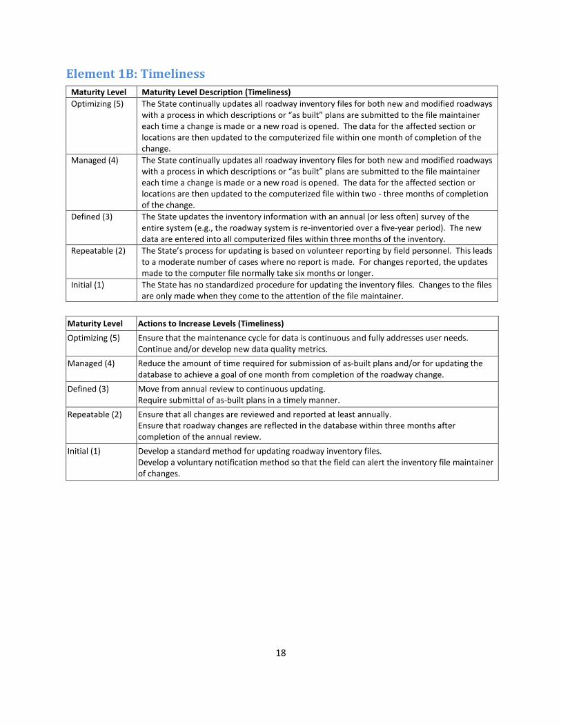
18
Element 1B: Timeliness
Maturity Level Maturity Level Description (Timeliness)
Optimizing (5) The State continually updates all roadway inventory files for both new and modified roadways with a process in which descriptions or “as built” plans are submitted to the file maintainer each time a change is made or a new road is opened. The data for the affected section or locations are then updated to the computerized file within one month of completion of the change.
Managed (4) The State continually updates all roadway inventory files for both new and modified roadways with a process in which descriptions or “as built” plans are submitted to the file maintainer each time a change is made or a new road is opened. The data for the affected section or locations are then updated to the computerized file within two - three months of completion of the change.
Defined (3) The State updates the inventory information with an annual (or less often) survey of the entire system (e.g., the roadway system is re-inventoried over a five-year period). The new data are entered into all computerized files within three months of the inventory.
Repeatable (2) The State’s process for updating is based on volunteer reporting by field personnel. This leads to a moderate number of cases where no report is made. For changes reported, the updates made to the computer file normally take six months or longer.
Initial (1) The State has no standardized procedure for updating the inventory files. Changes to the files are only made when they come to the attention of the file maintainer.
Maturity Level Actions to Increase Levels (Timeliness)
Optimizing (5) Ensure that the maintenance cycle for data is continuous and fully addresses user needs. Continue and/or develop new data quality metrics.
Managed (4) Reduce the amount of time required for submission of as-built plans and/or for updating the database to achieve a goal of one month from completion of the roadway change.
Defined (3) Move from annual review to continuous updating. Require submittal of as-built plans in a timely manner.
Repeatable (2) Ensure that all changes are reviewed and reported at least annually. Ensure that roadway changes are reflected in the database within three months after completion of the annual review.
Initial (1) Develop a standard method for updating roadway inventory files. Develop a voluntary notification method so that the field can alert the inventory file maintainer of changes.

19
Element 1C: Accuracy
Maturity Level Maturity Level Description (Accuracy)
Optimizing (5) The State has a high level of accuracy in their inventory data across all categories that they maintain (segments, intersections, curves, etc.). The existing values are very accurate as determined by a frequent systematic external verification process involving field data collection (e.g., surveys, field visits, and aerial photos). The State also has developed and uses a computerized set of internal verification checks for data reasonableness.
Managed (4) The State has a moderate to high level of accuracy in their inventory data across all categories that they maintain (segments, intersections, curves, etc.). The level of existing accuracy is verified by infrequent external verification with field data collection. The State also has developed and uses a computerized set of internal verification checks for data reasonableness.
Defined (3) The State has a moderate level of accuracy in their inventory data across all categories that they maintain (segments, intersections, curves, etc.). The data are believed to be moderately accurate, but the State does not conduct any kind of external verification process. The State also has developed and uses a computerized set of internal verification checks for data reasonableness.
Repeatable (2) The State has some subjective judgment of accuracy indicating a moderate level of accuracy across all categories that they maintain (segments, intersections, curves, etc.). The measure of accuracy is generally judgment based on maintainer/user familiarity with the data. There is no external verification with field data collection and no internal verification with checks for reasonableness.
Initial (1) The State has no measure of the accuracy of their inventory data and the accuracy of the data is felt to be low. There is no external verification with field data and no internal verification with checks for reasonableness.
Maturity Level Actions to Increase Levels (Accuracy)
Optimizing (5) Ensure that the external verification process cycle is maintained and expanded where necessary to meet users’ needs for validated accuracy levels.
Managed (4) Increase the frequency and breadth of external verifications such that more data elements are validated more often based on data collected in the field.
Defined (3) Establish external verification processes to compare the data in the database against data collected via field observations.
Repeatable (2) Develop some measures of accuracy. At a minimum, the State should develop a set of internal verification checks that compare data among many fields to ensure logical consistency.
Initial (1) Develop some measures of accuracy. At this point, it is not recommended that a state strive to achieve Level 2, as it is only marginally better than level 1. States should attempt to attain at least level 3 by developing internal validity checks for logical agreement among data fields.

20
Element 1D: Uniformity/Consistency
Maturity Level Maturity Level Description (Uniformity/Consistency)
Optimizing (5) The State has a high level of uniformity and consistency in element definitions and codes. Data coding is consistent across all State and non-State files. Procedures are in place to ensure that coding is consistent across multiple years and to ensure that particular locations on roadways can be tracked across multiple years.
Managed (4) The State has a moderate to high level of uniformity and consistency. Data coding is consistent across all State files but not non-State files. Procedures are in place to ensure that coding is consistent for all elements across multiple years and to ensure that particular locations on roadways can be tracked across multiple years.
Defined (3) The State has a moderate level of uniformity and consistency. Data coding is consistent across all State files but not non-State files. While procedures are in place to ensure that particular locations on roadways can be tracked across multiple years, procedures are not in place to ensure that coding for all elements is consistent across multiple years.
Repeatable (2) The State has a moderate level of uniformity and consistency. Data coding is consistent across all State files but not non-State files. Procedures are in place to ensure that coding for most elements is consistent across multiple years, but procedures are not in place to ensure that particular locations on roadways can be tracked across multiple years.
Initial (1) The State has a low level of uniformity and consistency. Data coding is not consistent across all State files or non-State files. There are no procedures are in place to ensure that coding is consistent across multiple years or to ensure that particular locations on roadways can be tracked across multiple years.
Maturity Level Actions to Increase Levels (Uniformity/Consistency)
Optimizing (5) Ensure that updates to the data collection forms and/or the database are reflected in standard data collection protocols and instruction manuals.
Managed (4) Ensure that data coding is consistent for all public roadways (not just state-maintained roadways).
Defined (3) Develop procedures to ensure that data elements are coded consistently across multiple years.
Repeatable (2) Develop procedures for tracking roadway locations across multiple years in the database.
Initial (1) Develop data coding standards and share them with all who submit or enter data. Conduct validation checks to assess uniformity/consistency across years.
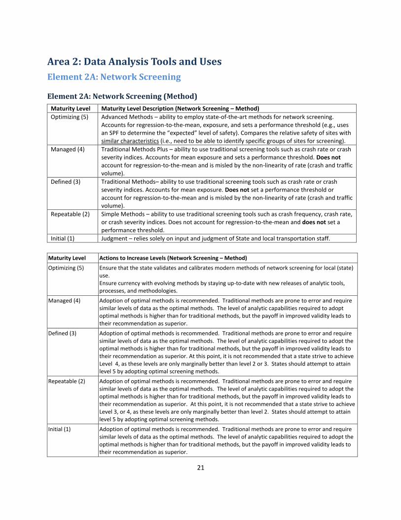
21
Area 2: Data Analysis Tools and Uses
Element 2A: Network Screening
Element 2A: Network Screening (Method)
Maturity Level Maturity Level Description (Network Screening – Method)
Optimizing (5) Advanced Methods – ability to employ state-of-the-art methods for network screening. Accounts for regression-to-the-mean, exposure, and sets a performance threshold (e.g., uses an SPF to determine the “expected” level of safety). Compares the relative safety of sites with similar characteristics (i.e., need to be able to identify specific groups of sites for screening).
Managed (4) Traditional Methods Plus – ability to use traditional screening tools such as crash rate or crash severity indices. Accounts for mean exposure and sets a performance threshold. Does not account for regression-to-the-mean and is misled by the non-linearity of rate (crash and traffic volume).
Defined (3) Traditional Methods– ability to use traditional screening tools such as crash rate or crash severity indices. Accounts for mean exposure. Does not set a performance threshold or account for regression-to-the-mean and is misled by the non-linearity of rate (crash and traffic volume).
Repeatable (2) Simple Methods – ability to use traditional screening tools such as crash frequency, crash rate, or crash severity indices. Does not account for regression-to-the-mean and does not set a performance threshold.
Initial (1) Judgment – relies solely on input and judgment of State and local transportation staff.
Maturity Level Actions to Increase Levels (Network Screening – Method)
Optimizing (5) Ensure that the state validates and calibrates modern methods of network screening for local (state) use. Ensure currency with evolving methods by staying up-to-date with new releases of analytic tools, processes, and methodologies.
Managed (4) Adoption of optimal methods is recommended. Traditional methods are prone to error and require similar levels of data as the optimal methods. The level of analytic capabilities required to adopt optimal methods is higher than for traditional methods, but the payoff in improved validity leads to their recommendation as superior.
Defined (3) Adoption of optimal methods is recommended. Traditional methods are prone to error and require similar levels of data as the optimal methods. The level of analytic capabilities required to adopt the optimal methods is higher than for traditional methods, but the payoff in improved validity leads to their recommendation as superior. At this point, it is not recommended that a state strive to achieve Level 4, as these levels are only marginally better than level 2 or 3. States should attempt to attain level 5 by adopting optimal screening methods.
Repeatable (2) Adoption of optimal methods is recommended. Traditional methods are prone to error and require similar levels of data as the optimal methods. The level of analytic capabilities required to adopt the optimal methods is higher than for traditional methods, but the payoff in improved validity leads to their recommendation as superior. At this point, it is not recommended that a state strive to achieve Level 3, or 4, as these levels are only marginally better than level 2. States should attempt to attain level 5 by adopting optimal screening methods.
Initial (1) Adoption of optimal methods is recommended. Traditional methods are prone to error and require similar levels of data as the optimal methods. The level of analytic capabilities required to adopt the optimal methods is higher than for traditional methods, but the payoff in improved validity leads to their recommendation as superior.

22
Element 2A: Network Screening (Data)
Maturity Level Maturity Level Description (Network Screening – Data)
Optimizing (5) System Plus Analysis – based on roadway inventory data (e.g., ability to screen all curves or intersections of a certain type to determine sites with most promise), incorporating traffic volume data and crash data along with citation, driver, or injury outcome data.
Managed (4) System Analysis – based on roadway inventory data (e.g., ability to screen all curves or intersections of a certain type to determine sites with most promise), incorporating traffic volume data and crash data (e.g., use of SafetyAnalyst).
Defined (3) Crash-Based Plus – based on crash data with traffic or roadway inventory linked. Difficult to identify “zero-crash” locations.
Repeatable (2) Crash-Based – based on crash data only (or fatal crash only). Does not link traffic or roadway inventory data.
Initial (1) Solicited Input – severe lack of crash data. Must rely on input from district/county/local staff or citizen complaints to identify sites for improvement.
Maturity Level Actions to Increase Levels (Network Screening – Data)
Optimizing (5) Ensure ongoing availability and use of linked data from multiple traffic records data sources.
Managed (4) Develop additional linkages between crash and other relevant traffic records databases (citation, driver, vehicle, injury surveillance, etc.)
Defined (3) Ensure linkage of crashes with both traffic and roadway inventory data. Ensure sufficient linked database coverage to include locations with zero crash frequency.
Repeatable (2) If only fatal crash data are used, work to ensure that data at all levels of crash severity are obtained and used. Develop linkages between crash and roadway data (traffic and inventory).
Initial (1) Work to obtain sufficient crash data to support safety analysis. The data should include all levels of severity and cover all public roads.
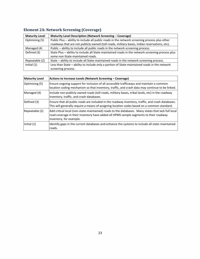
23
Element 2A: Network Screening (Coverage)
Maturity Level Maturity Level Description (Network Screening – Coverage)
Optimizing (5) Public Plus – ability to include all public roads in the network screening process plus other roadways that are not publicly owned (toll-roads, military bases, Indian reservations, etc).
Managed (4) Public – ability to include all public roads in the network screening process.
Defined (3) State Plus – ability to include all State-maintained roads in the network screening process plus some non-State-maintained roads.
Repeatable (2) State – ability to include all State-maintained roads in the network screening process.
Initial (1) Less than State – ability to include only a portion of State-maintained roads in the network screening process.
Maturity Level Actions to Increase Levels (Network Screening – Coverage)
Optimizing (5) Ensure ongoing support for inclusion of all accessible trafficways and maintain a common location coding mechanism so that inventory, traffic, and crash data may continue to be linked.
Managed (4) Include non-publicly owned roads (toll roads, military bases, tribal lands, etc) in the roadway inventory, traffic, and crash databases.
Defined (3) Ensure that all public roads are included in the roadway inventory, traffic, and crash databases. This will generally require a means of assigning location codes based on a common standard.
Repeatable (2) Add critical local (non-state-maintained) roads to the databases. Many states that lack full local road coverage in their inventory have added all HPMS sample segments to their roadway inventory, for example.
Initial (1) Identify gaps in the current databases and enhance the systems to include all state-maintained roads.

24
Element 2B: Diagnosis
Maturity Level Maturity Level Description (Diagnosis)
Optimizing (5) Ability to generate relevant statistics and summaries for any specific site or corridor (includes all public roads). Statistics include total crashes for a given study period by type, severity, time of day, day of week, date, road condition (dry, wet, etc), lighting condition (light, dark-lit, dark-unlit, etc), weather condition (clear, rain, snow), and driver impairment. Summaries include the ability to generate a condition diagram (shows roadway and roadside characteristics) and a collision diagram (shows locations of crashes relative to the study section and vehicle movements and other elements found in the crash report). Can calculate over-representation of crashes – similar to SafetyAnalyst. Roadway data should be sufficient to generate a reliable condition diagram without site-specific field measurements. Roadway data for the condition diagram may include lane width, shoulder width, lighting presence, traffic control, signal phasing, posted speed, etc.
Managed (4) Ability to generate a portion of the relevant statistics listed above for any specific site or corridor (includes all public roads). State has the ability to generate a collision and a condition diagram, although some of the data for the condition diagram may have to be measured in the field or obtained from aerial imagery (i.e., are not available as electronic database).
Defined (3) Ability to generate relevant statistics and summaries for a portion of the network. Statistics include total crashes for a given study period by type, severity, time of day, day of week, date, road condition (dry, wet, etc), lighting condition (light, dark-lit, dark-unlit, etc), weather condition (clear, rain, snow), and driver impairment. Summaries include the ability to generate a condition diagram (shows roadway and roadside characteristics) and a collision diagram (shows locations of crashes relative to the study section). Some of the data for the condition diagram may have to be measured in the field or obtained from aerial imagery (i.e., are not available as electronic database).
Repeatable (2) Ability to generate a portion of the relevant statistics listed above for a portion of the network. State also has the ability to generate a collision or condition diagram.
Ad-hoc (1) Very limited ability to generate statistics for any portion of the network. State may have difficulty generating a collision or condition diagram. Must rely heavily on site visits to assess potential safety issues.
Maturity Level Actions to Increase Levels (Diagnosis)
Optimizing (5) Ensure that detailed data on roadway features/attributes are maintained on a sufficient schedule to meet users’ needs.
Managed (4) Develop feature-specific reports of over-representation in crashes. Enhance the roadway data to support generation of condition diagrams solely from database contents.
Defined (3) Develop reports for all public roadways.
Repeatable (2) Develop comprehensive summary reports describing site-specific crash experience. Ensure that both collision and condition diagrams can be generated for any site of interest.
Ad-hoc (1) Develop analytic reports to summarize crash experience at specific sites of interest.

25
Element 2C: Countermeasure Selection
Maturity Level Maturity Level Description (Countermeasure Selection)
Optimizing (5) State has the ability to determine all existing safety-related infrastructure attributes for any specific site or corridor (includes all public roads) without a site visit. Includes complete roadway data for intersections, curves, tangents, interchanges, and at-grade rail crossings. Also includes peripheral safety databases such as sign inventory, lighting presence and condition, pavement condition, presence and condition of pavement markings, etc.
Managed (4) State has the ability to determine a portion of the existing safety-related infrastructure attributes for any specific site or corridor (includes all public roads). May require a site visit or use of aerial imagery to determine certain attributes.
Defined (3) State has the ability to determine all existing safety-related infrastructure attributes for a portion of the network. Includes peripheral safety databases such as sign inventory, lighting presence and condition, pavement condition, presence and condition of pavement markings, etc. for that portion of the network.
Repeatable (2) State has the ability to determine a portion of the existing safety-related infrastructure attributes for a portion of the network. May require a site visit or use of aerial imagery to determine certain attributes.
Initial (1) Very limited ability to determine existing safety-related infrastructure attributes for any portion of the network. Must rely heavily on site visits to assess potential safety issues.
Maturity Level Actions to Increase Levels (Countermeasure Selection)
Optimizing (5) Maintain the data on roadway safety-related infrastructure attributes on a cycle that meets the needs of users.
Managed (4) Include all public roads in the inventory at the same high level of detailed safety-related infrastructure attributes.
Defined (3) Include all public roads in the inventory at the same high level of detailed safety-related infrastructure attributes.
Repeatable (2) Enhance the roadway inventory to include a full data element list of all safety-related infrastructure attributes.
Initial (1) Develop/enhance the roadway inventory database to expand coverage of the network and features (safety-related infrastructure).

26
Element 2D: Evaluation
Element 2D: Evaluation
Maturity Level Maturity Level Description (Evaluation)
Optimizing (5) Project Level: Ability to conduct a rigorous before-after project-level evaluation, accounting for regression-to-the-mean, traffic volume trends, and temporal trends (i.e., changes over time other than the treatment or project of interest). State has the ability to perform this type of evaluation for any project (i.e., requires data on all roads in the State). This type of evaluation is carried out by applying the empirical Bayes before-after observational study. Requires installation data and 5+ years of historical crash and respective annual traffic volume data for treatment and non-treatment sites, and will develop SPFs for the evaluation study. Program Level: Ability to evaluate the effectiveness of specific programs, including the cost and potential benefit. Requires project level data to identify the number of projects by type (so projects can be associated with a specific program), the cost of projects by type, and the relative timeframe of installation. Also requires crash data on a statewide basis with information on specific crash types and contributing factors. Exposure data (e.g., VMT) are available to account for changes over time and 5+ years of crash data are available to account for other time trends.
Managed (4) Project Level: Ability to conduct a rigorous before-after project-level evaluation, accounting for regression-to-the-mean, traffic volume trends, and temporal trends (i.e., changes over time other than the treatment or project of interest). State has the ability to perform this type of evaluation for some projects (i.e., requires data on a subset of roads in the state). This type of evaluation is carried out by applying the empirical Bayes before-after observational study. Requires installation data and 5+ years of historical crash and respective annual traffic volume data for treatment and non-treatment sites, and will develop SPFs for the evaluation study. Program Level: Ability to evaluate the effectiveness of specific programs, including the cost and potential benefit. Requires project level data to identify the number of projects by type (so projects can be associated with a specific program), the cost of projects by type, and the relative timeframe of installation. Also requires crash data on a statewide basis with information on specific crash types and contributing factors. One of the following is also available: 1. Exposure data (e.g., VMT) are available to account for changes over time. 2. 5+ years of crash data are available to account for other time trends (5+ years of data helps to establish
trends versus 4 or fewer years).
Defined (3) Project Level: Ability to conduct cross-sectional project-level evaluations. The State has crash, traffic volume, and roadway data for specific projects. An empirical Bayes analysis is not possible because either the State does not track the specific installation date OR there are fewer than 5 years of historical data available for analysis (not enough years to develop stable estimates of expected crashes in the before and after period). Program Level: Project-level data are available, but incomplete. May not include cost data, exposure data, or may not have 5+ years of crash data available for analysis.
Repeatable (2) Project Level: Ability to conduct a simple before-after project-level evaluation. Accounts for traffic volume changes, but does not account for regression-to-the-mean or temporal trends (i.e., changes over time other than the treatment/project of interest). Installation, crash, and traffic volume data are available for the treatment site(s) of interest, but not for a reference/comparison group (i.e., non-treatment sites). Program Level: Crash data are available for at least all State-maintained roads to evaluate the overall performance of the State, but not at the project level to determine the effectiveness of a specific program.
Initial (1) Project Level: Ability to conduct a simple before-after or anecdotal project-level evaluation. Does not account for regression-to-the-mean, traffic volume trends, or temporal trends (i.e., changes over time other than the treatment/project of interest). Installation and crash data are available for the treatment site(s) of interest, but not for a reference/comparison group (i.e., non-treatment sites). Program Level: Anecdotal program-level evaluation. Data are not available to support specific program evaluations.

27
Maturity Level Actions to Increase Levels (Evaluation)
Optimizing (5) Ensure that the data refresh cycle is maintained and meets the needs of users. Ensure that the refresh cycle for data is sufficient to meet users’ needs.
Managed (4) Develop a complete inventory and safety-project tracking mechanism for all public roads. Ensure that a 5+ year history is available for all locations in the database. Develop both traffic volume and crash data history for all public roadways.
Defined (3) Ensure that installation dates are tracked for all safety-related countermeasures. Develop a five-year minimum historical database for crashes and traffic volume data. Ideally, the databases would cover all public roads, but could be accomplished by collecting data for a specific subset of roadway locations. Develop methods of analyzing cost/benefit of projects/programs. Ensure that all safety-related programs are tracked by installation date, location, and relevant program. Move toward collection of statewide data for crash and traffic volume. Maintain historical data for at least one of these.
Repeatable (2) Develop a comprehensive dataset to include non-treatment sites as a reference/comparison group. Ideally, this would include data on all public roads, but could be accomplished by collecting evaluation data on selected sites, some of which remain untreated. Develop the ability to track project/program-level outcomes. Ideally, project-level data will include 5+ years of crash data, project implementation dates and cost, and project-specific traffic volume estimates.
Initial (1) Develop datasets supporting analyses that can account for changes in travel volume over time. Develop data resources to support statewide safety evaluation. This should include crash, statewide traffic volume estimates.

28
Element 2E: Accessibility
Maturity Level Maturity Level Description (Accessibility)
Optimizing (5) State has a formal process for requesting data and the ability to provide data to all safety partners, including the public, within a defined timeline.
Managed (4) State has an informal process for requesting data and the ability to provide data to all safety partners.
Defined (3) State has a formal process for requesting data and the ability to provide data to some safety partners within a defined timeline.
Repeatable (2) State has an informal process for requesting data and the ability to provide data to some safety partners.
Initial (1) Few individuals within the DOT are granted access to the data.
Maturity Level Actions to Increase Levels (Accessibility)
Optimizing (5) Ensure that the needs of new/infrequent users are addressed by agency policies and procedures.
Managed (4) Formalize the data request process.
Defined (3) Develop policies and procedures to meet the data needs of all safety partners.
Repeatable (2) Develop data access policies to broaden the list of who may have direct access to the data, and how others may make requests for data. The policies should address any requirements to review requests and collect signatures on release statements.
Initial (1) Develop data access policies to broaden the list of who may have direct access to the data, and how others may make requests for data. The policies should address any requirements to review requests and collect signatures on release statements.
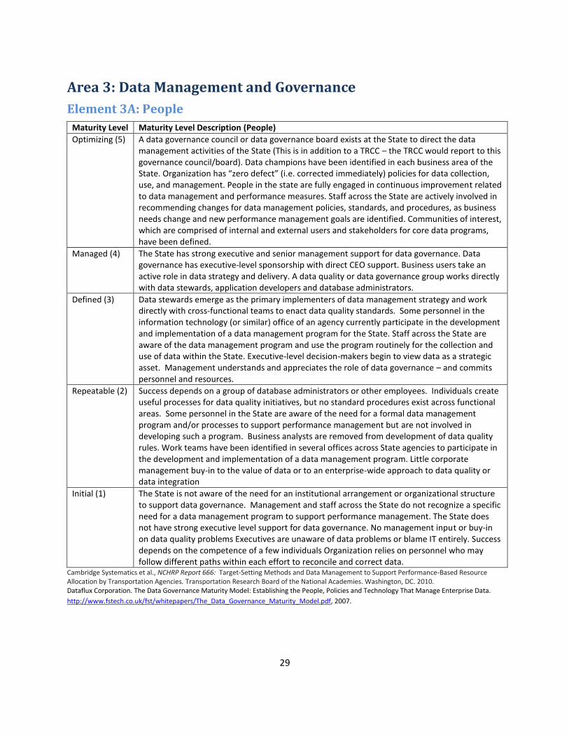
29
Area 3: Data Management and Governance
Element 3A: People
Maturity Level Maturity Level Description (People)
Optimizing (5) A data governance council or data governance board exists at the State to direct the data management activities of the State (This is in addition to a TRCC – the TRCC would report to this governance council/board). Data champions have been identified in each business area of the State. Organization has “zero defect” (i.e. corrected immediately) policies for data collection, use, and management. People in the state are fully engaged in continuous improvement related to data management and performance measures. Staff across the State are actively involved in recommending changes for data management policies, standards, and procedures, as business needs change and new performance management goals are identified. Communities of interest, which are comprised of internal and external users and stakeholders for core data programs, have been defined.
Managed (4) The State has strong executive and senior management support for data governance. Data governance has executive-level sponsorship with direct CEO support. Business users take an active role in data strategy and delivery. A data quality or data governance group works directly with data stewards, application developers and database administrators.
Defined (3) Data stewards emerge as the primary implementers of data management strategy and work directly with cross-functional teams to enact data quality standards. Some personnel in the information technology (or similar) office of an agency currently participate in the development and implementation of a data management program for the State. Staff across the State are aware of the data management program and use the program routinely for the collection and use of data within the State. Executive-level decision-makers begin to view data as a strategic asset. Management understands and appreciates the role of data governance – and commits personnel and resources.
Repeatable (2) Success depends on a group of database administrators or other employees. Individuals create useful processes for data quality initiatives, but no standard procedures exist across functional areas. Some personnel in the State are aware of the need for a formal data management program and/or processes to support performance management but are not involved in developing such a program. Business analysts are removed from development of data quality rules. Work teams have been identified in several offices across State agencies to participate in the development and implementation of a data management program. Little corporate management buy-in to the value of data or to an enterprise-wide approach to data quality or data integration
Initial (1) The State is not aware of the need for an institutional arrangement or organizational structure to support data governance. Management and staff across the State do not recognize a specific need for a data management program to support performance management. The State does not have strong executive level support for data governance. No management input or buy-in on data quality problems Executives are unaware of data problems or blame IT entirely. Success depends on the competence of a few individuals Organization relies on personnel who may follow different paths within each effort to reconcile and correct data.
Cambridge Systematics et al., NCHRP Report 666: Target-Setting Methods and Data Management to Support Performance-Based Resource Allocation by Transportation Agencies. Transportation Research Board of the National Academies. Washington, DC. 2010. Dataflux Corporation. The Data Governance Maturity Model: Establishing the People, Policies and Technology That Manage Enterprise Data.
http://www.fstech.co.uk/fst/whitepapers/The_Data_Governance_Maturity_Model.pdf, 2007.
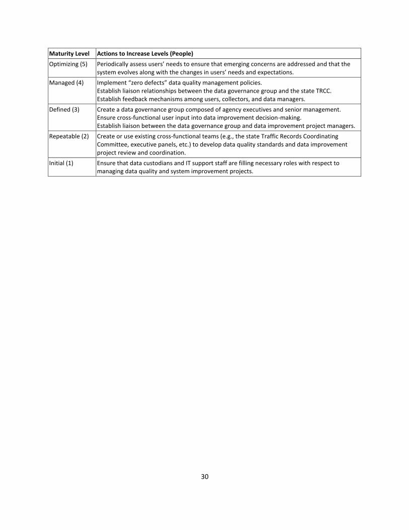
30
Maturity Level Actions to Increase Levels (People)
Optimizing (5) Periodically assess users’ needs to ensure that emerging concerns are addressed and that the system evolves along with the changes in users’ needs and expectations.
Managed (4) Implement “zero defects” data quality management policies. Establish liaison relationships between the data governance group and the state TRCC. Establish feedback mechanisms among users, collectors, and data managers.
Defined (3) Create a data governance group composed of agency executives and senior management. Ensure cross-functional user input into data improvement decision-making. Establish liaison between the data governance group and data improvement project managers.
Repeatable (2) Create or use existing cross-functional teams (e.g., the state Traffic Records Coordinating Committee, executive panels, etc.) to develop data quality standards and data improvement project review and coordination.
Initial (1) Ensure that data custodians and IT support staff are filling necessary roles with respect to managing data quality and system improvement projects.

31
Element 3B: Policies
Maturity Level Maturity Level Description (Policies)
Optimizing (5) New initiatives are only approved after careful consideration of how the initiatives will impact the existing data infrastructure. Automated policies are in place to ensure that data remains consistent, accurate and reliable throughout the enterprise.
Managed (4) Goals shift from problem correction to prevention. Real-time activities and preventive data quality rules and processes emerge. A service oriented architecture (SOA) encapsulates business rules for data quality and identity management. Data metrics are measured against industry standards to provide insight into areas needing improvement. An enterprise Data Business Plan has been developed to support management of core data programs across the agency and has been incorporated into the overall State strategic plan. The State has developed and published a Data Governance manual or handbook which identifies the roles and responsibilities of staff in the state to support data governance operations. It has developed a data catalog with data definitions, standards, policies, and procedures for the collection and use of data in the organization. The catalog is available on an enterprise basis electronically.
Defined (3) Rules for data governance emerge, but the emphasis remains on correcting data issues as they occur. Within groups and departments, tasks and roles are standardized. Data governance processes are built. A number of State agencies have implemented a Data Business Plan to manage the core data programs for their area. Data metrics are sometimes measured against industry standards to provide insight into areas needing improvement
Repeatable (2) Data quality is project focused only, with limited defined data quality processes. “Firefighting mode.” Address problems as they occur through manually-driven processes. Most data management processes are short-range and focus on recently discovered problems. Data and data processing is siloed – systems operate independently. Resources are not optimized due to redundant, outdated data. State senior management recognizes the need for a Data Business Plan to manage critical data programs; however, a plan has not yet been developed or the State is developing a Data Business Plan to support management of strategic data programs.
Initial (1) The State does not have a Data Business Plan in place to support management of core data programs. The State does not have defined roles, such as data stewards, stakeholders, business owners (of data), and communities of interest, to support a data governance framework. Data quality is non-existent, with no defined data quality processes
Cambridge Systematics et al., NCHRP Report 666: Target-Setting Methods and Data Management to Support Performance-Based Resource Allocation by Transportation Agencies. Transportation Research Board of the National Academies. Washington, DC. 2010. Dataflux Corporation. The Data Governance Maturity Model: Establishing the People, Policies and Technology That Manage Enterprise Data.
http://www.fstech.co.uk/fst/whitepapers/The_Data_Governance_Maturity_Model.pdf, 2007.
Maturity Level Actions to Increase Levels (Policies)
Optimizing (5) Adjust policies to ensure that they help, and do not hinder, legitimate progress in system development or enhancement.
Managed (4) Establish formal policies for approval of all new data management initiatives.
Defined (3) Develop problem prevention strategies. Benchmark data quality against industry standards. Publish a Data Governance manual/handbook. Develop a data catalog.
Repeatable (2) Develop a Data Business Plan for managing core data programs in each agency. Empanel a data governance group charged with developing data governance processes.
Initial (1) Develop defined roles for data stewards (custodians of data resource), business owners of the data, communities of interest, stakeholders, and others.

32
Element 3C: Technology Maturity Level Maturity Level Description (Technology)
Optimizing (5) Data are continuously inspected – and any deviations from standards are resolved immediately. Ongoing data monitoring helps the data stewards maintain data integrity. The use of technology and tools in the State improves the overall management of programs in the State, in accordance with the strategic mission, goals, and targets. Data models capture the business meaning and technical details of all corporate data elements. Performance management tools, such as dashboards and scorecards, are used in every involved office of the State to monitor the progress of State programs in meeting the State mission and goals. Performance measures and targets are adjusted as needed and displayed on the State dashboard, or similar mechanism, to maintain peak program performance across the State.
Managed (4) A data stewardship group maintains corporate data definitions and business rules. Data quality and data integration tools are standardized across the organization. All aspects of the organization use standard business rules created and maintained by designated data stewards. More real-time processing is available and data quality functionality is shared across different operation modes. The State uses Service Oriented Architecture (SOA) as the enterprise standard and Open Database Connectivity (ODBC) in the development of new applications to support future integration of applications.
Defined (3) Database administration tactics emerge. Tactical data quality tools are often available. Applications utilize data quality technology. The State uses information technology tools on a widespread basis, including such applications as an enterprise data warehouse, GIS systems which integrate business data from various offices, and dashboards and scorecards delivered through a web-enabled interface for access state-wide.
Repeatable (2) Data cleansing and standardization occurs only in isolated data sources. Data improvement is focused on single applications. Agencies have delegated the responsibility to a specific office, such as Information Technology, to determine what IT tools are needed to support data management across the agency. Most data are not integrated across business units; some departments attempt isolated integration efforts. Agencies have implemented some information technology tools, including GIS, data models, data repositories, data dictionaries, etc., to support data management in certain offices of the agency.
Initial (1) The State does not have any information technology tools in place to support data management. No data profiling, analysis or auditing is used
Cambridge Systematics et al., NCHRP Report 666: Target-Setting Methods and Data Management to Support Performance-Based Resource Allocation by Transportation Agencies. Transportation Research Board of the National Academies. Washington, DC. 2010. Dataflux Corporation. The Data Governance Maturity Model: Establishing the People, Policies and Technology That Manage Enterprise Data. http://www.fstech.co.uk/fst/whitepapers/The_Data_Governance_Maturity_Model.pdf, 2007.
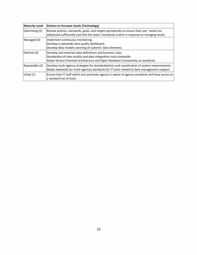
33
Maturity Level Actions to Increase Levels (Technology)
Optimizing (5) Review policies, standards, goals, and targets periodically to ensure that user’ needs are addressed sufficiently and that the state’s standards evolve in response to changing needs.
Managed (4) Implement continuous monitoring. Develop a statewide data quality dashboard. Develop data models covering all systems’ data elements.
Defined (3) Develop and maintain data definitions and business rules. Standardize all data quality and data integration tools statewide. Adopt Service Oriented Architecture and Open Database Connectivity as standards.
Repeatable (2) Develop multi-agency strategies for standardization and coordination of system improvements. Adopt statewide (or multi-agency) standards for IT tools related to data management support.
Initial (1) Ensure that IT staff within any particular agency is aware of agency standards and have access to a standard set of tools.

34
Area 4: Data Interoperability and Expandability Element 4A: Interoperability
Maturity Level Maturity Level Description (Interoperability)
Optimizing (5) Safety analysis uses linked data sets from sources including roadway, crash, injury surveillance, citation, and/or others. The linked data sets are considered reliable for supporting decision making. Analysis of merged data is a regular feature of safety analysis
Managed (4) Safety analyses using linked datasets from roadway, crash and at least one other traffic records data source are supported. Though not a standard feature of all safety analyses in the State, such analyses of merged data are not uncommon or difficult to find
Defined (3) Safety analysis using merged data from roadway and crash records is common, but other analyses (for example, using injury surveillance data) are rare.
Repeatable (2) Safety analysis using merged roadway and crash data is the performed for some, but not all roadway/roadway types. Other examples of analyses using merged datasets are rare and not well used in support of safety decision making
Initial (1) There are few or no examples of safety analysis using merged datasets. The reliability of the linkage between roadway and crash data is considered to be problematic.
Maturity Level Actions to Increase Levels (Interoperability)
Optimizing (5) Identify new opportunities to merge datasets. Continue to encourage use of linked data in safety analysis.
Managed (4) Encourage use of linked data in analyses, especially those related to crash consequences, crash/injury severity associated with various crash and roadway contributing factors, and others.
Defined (3) Create linked datasets including crash, roadway, and at least one other traffic records data source (e.g., injury surveillance data).
Repeatable (2) Encourage use of linked crash and roadway data for safety analyses.
Initial (1) Create linked datasets of crash and roadway (inventory and traffic) data.

35
Element 4B: Expandability
Maturity Level Maturity Level Description (Expandability)
Optimizing (5) Within the State DOT, modern database design and enterprise-wide planning mean that adding coverage or data elements is built in to systems and thinking about systems improvements. Data transfers among agencies (especially local and State) are primarily electronic and automated as fully as possible. Linkage among systems is accomplished primarily in an automated fashion. Analytic tools are fully integrated and “seamless” access is provided to users. Full spatial analysis capabilities are available.
Managed (4) Within the State DOT Systems are written in modern languages with modern database structures/designs. Adding new data elements or additional roadway miles/segments is generally easy, but may have been done separately for some system components. There are common platforms, but not a single system for enterprise-wide databases or software. Data linkage is generally automated among the DOT’s main systems, but some data sources require manual effort to convert to a common location coding scheme. Analytic tools (including GIS) exist and some capability for spatial analysis exists. Expansion of systems would be difficult, but not impossible to coordinate.
Defined (3) Within the State DOT system components are of mixed vintage, built to different standards and are separately maintained. Adding new data elements or additional roadway miles/segments is possible, but will have been done separately for some system components. Movement is toward a common standard for software and database, but the implementation of full integration, enterprise-wide solutions is several years in the future. Some data linkage is automated, but some is manual and labor intensive. Expansion of the older systems is considered too expensive and not worth the effort given their eventual replacement is planned. For critical expansions, a minimal design to get the job done is the standard. Newer systems are easily expandable. Spatial data are really just used in visualization of layers in the GIS – no (or very limited) spatial analysis capabilities.
Repeatable (2) Within the State DOT, a small number of systems are modern, and the rest are considered legacy. Adding new data elements or additional roadway miles/segments is difficult and piecemeal. The plans for replacement of older components are “long term”, not currently funded, or stalled. Data linkage is difficult requiring many different “mappings” among location coding schemes and system designs. Much of the work is manual or simply not performed. Spatial display of data is limited and not well-integrated into safety analysis efforts.
Initial (1) Within the State DOT, the majority of data sources are stand-alone systems, of varying vintage, design, and software. Adding new data elements or additional roadway miles/segments is usually not done. Data linkage is either difficult or impossible, depending on the system components in question. Linkage to external (outside the DOT) sources is not generally possible. Use of GIS in safety analysis is limited, not covering a significant portion of the public roads, crashes, or other key data.

36
Maturity Level Actions to Increase Levels (Expandability)
Optimizing (5) Plan for system lifecycle and maintenance to ensure that systems remain up-to-date. Aid local agencies in maintaining compatibility with evolving statewide systems.
Managed (4) Implement enterprise-wide systems. Create fully automated linkages among system modules/databases. Support electronic data transfer between local agencies and the DOT.
Defined (3) Plan for enterprise-wide system architecture. Implement GIS standard tools for visualization and spatial analysis.
Repeatable (2) Develop a “near term” plan for system modernization, including funding for the effort. Ideally, the plan will incorporate standardized systems, moving toward an enterprise-wide solution. Develop automated linkages among the new/updated systems.
Initial (1) Plan for the development of modern systems using a single standard. It is recommended that the plan be designed for achievement of at least level 4, but recognizing that the state may pass through levels 2 and 3 on the way to achieving higher levels.
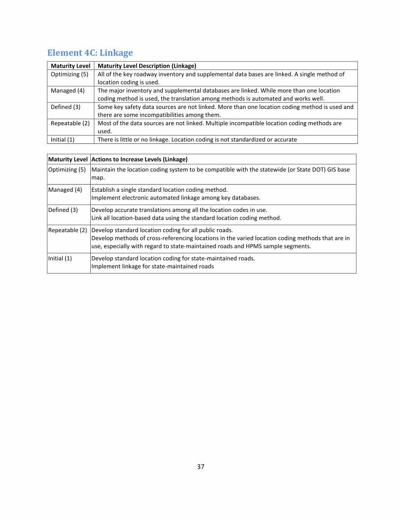
37
Element 4C: Linkage
Maturity Level Maturity Level Description (Linkage)
Optimizing (5) All of the key roadway inventory and supplemental data bases are linked. A single method of location coding is used.
Managed (4) The major inventory and supplemental databases are linked. While more than one location coding method is used, the translation among methods is automated and works well.
Defined (3) Some key safety data sources are not linked. More than one location coding method is used and there are some incompatibilities among them.
Repeatable (2) Most of the data sources are not linked. Multiple incompatible location coding methods are used.
Initial (1) There is little or no linkage. Location coding is not standardized or accurate
Maturity Level Actions to Increase Levels (Linkage)
Optimizing (5) Maintain the location coding system to be compatible with the statewide (or State DOT) GIS base map.
Managed (4) Establish a single standard location coding method. Implement electronic automated linkage among key databases.
Defined (3) Develop accurate translations among all the location codes in use. Link all location-based data using the standard location coding method.
Repeatable (2) Develop standard location coding for all public roads. Develop methods of cross-referencing locations in the varied location coding methods that are in use, especially with regard to state-maintained roads and HPMS sample segments.
Initial (1) Develop standard location coding for state-maintained roads. Implement linkage for state-maintained roads

38
Appendix D: Potential Funding Sources (link to website)
Rank Funding Pools Description/Objectives Specific Data
Types Annual Funding
Federal Share
+++
State Traffic Safety Information System Improvement Grants (Sec 408) National Highway Traffic Safety Administration (NHTSA)
Encourage States to adopt and implement effective programs to improve the timeliness, accuracy, completeness, uniformity, integration and accessibility of State data; to evaluate the effectiveness of efforts to make such improvements; to link these State data systems, including traffic records, with other data systems within the State; and to improve the compatibility of the State data systems with national data systems and data systems of other States to enhance the ability to observe and analyze national trends in crash occurrences, rates, outcomes, and circumstances.
Any
Varies per state: $500,000 to $2,344,000. The amount available for each state in 2010: http://www.ghsa.org/html/stateinfo/programs/funding10.html
80%
+++
Highway Research and Development Program Federal Highway Administration (FHWA)
To carry out the highway research and development program as authorized by SAFETEA-LU. To conduct research needed to maintain and grow our vital transportation infrastructure. SAFETEA-LU addresses the many challenges facing our transportation system today challenges such as improving safety, reducing traffic congestion, improving efficiency in freight movement, increasing intermodal connectivity, and protecting the environment as well as laying the groundwork for addressing future challenges.
Any (ASSUMPTION based in "improving safety" objective))
$14 M (total for FY 2010) Range and Average of Financial Assistance: varies by project
100%

39
+++
Highway Planning and Construction Federal Highway Administration (FHWA)
To assist State transportation agencies in the planning and development of an integrated, interconnected transportation system important to interstate commerce and travel by constructing and rehabilitating the National Highway System (NHS), including the Eisenhower Interstate System; and for transportation improvements to most other public roads; to provide aid for the repair of Federal-aid highways following disasters; to foster safe highway design; to replace or rehabilitate deficient or obsolete bridges; and to provide for other special purposes.
Any (ASSUMPTION based on "foster safe highway design, and planning / development of an integrated system)
2011 Estimate: Grants $43,163,321; Highway Infrastructure Investment $13,000.
100%
+++
State and Community Highway Safety Grants (Sec 402) National Highway Traffic Safety Administration (NHTSA)
The program is intended to assist states and communities in the development and implementation of highway safety programs designed to reduce traffic crashes, deaths, injuries and property damage. 402 funds can be spent in nine national priority areas: Alcohol countermeasures | Occupant protection | Police traffic services (e.g. enforcement) | Emergency medical services | Traffic records | Motorcycle safety | Pedestrian and bicycle safety (jointly administered by FHWA and NHTSA) | Non-construction aspects of roadway safety (administered by FHWA) | Speed control (jointly administered by NHTSA and FHWA)
Any data supporting highway safety programs (ASSUMPTION based on description referring to traffic records and non-construction aspects of roadway safety)
Varies per state: $587,175 to $21,376,394 Values for FY 2010
80%
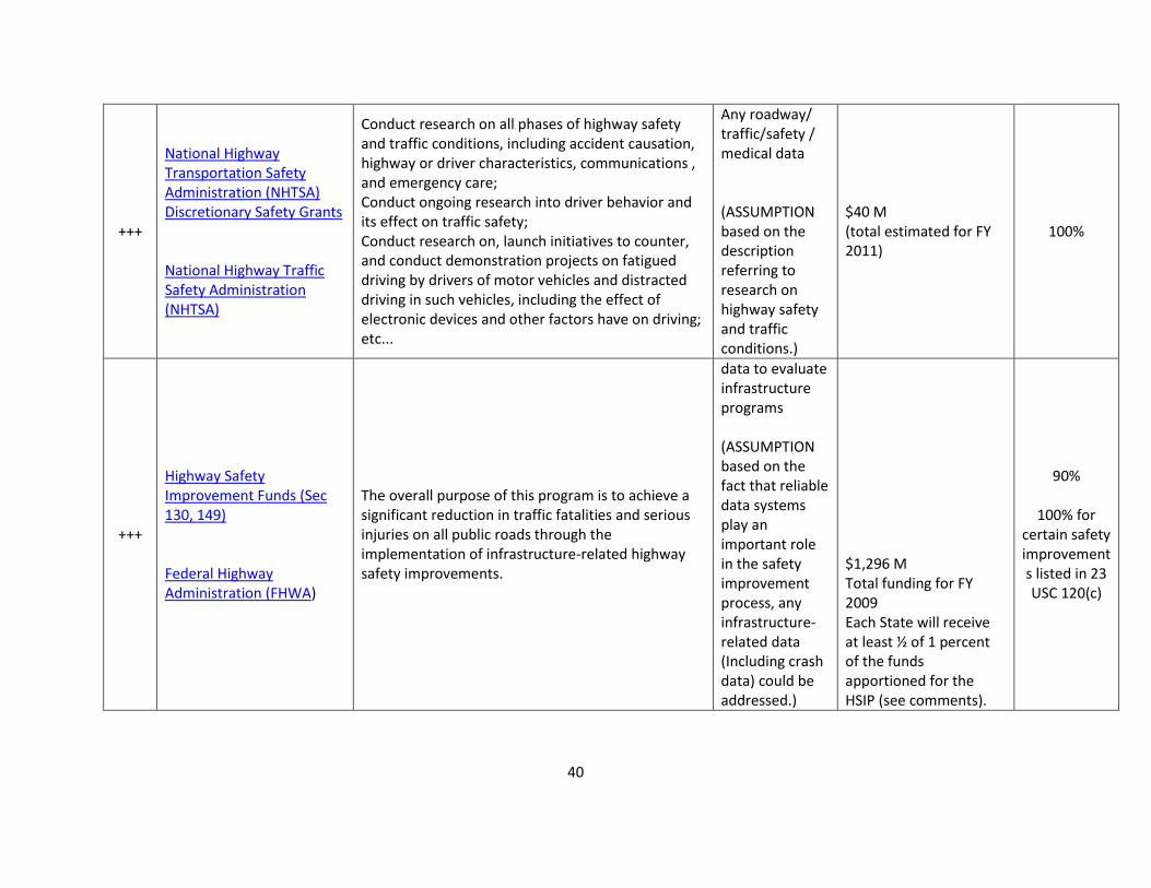
40
+++
National Highway Transportation Safety Administration (NHTSA) Discretionary Safety Grants National Highway Traffic Safety Administration (NHTSA)
Conduct research on all phases of highway safety and traffic conditions, including accident causation, highway or driver characteristics, communications , and emergency care; Conduct ongoing research into driver behavior and its effect on traffic safety; Conduct research on, launch initiatives to counter, and conduct demonstration projects on fatigued driving by drivers of motor vehicles and distracted driving in such vehicles, including the effect of electronic devices and other factors have on driving; etc...
Any roadway/ traffic/safety / medical data (ASSUMPTION based on the description referring to research on highway safety and traffic conditions.)
$40 M (total estimated for FY 2011)
100%
+++
Highway Safety Improvement Funds (Sec 130, 149) Federal Highway Administration (FHWA)
The overall purpose of this program is to achieve a significant reduction in traffic fatalities and serious injuries on all public roads through the implementation of infrastructure-related highway safety improvements.
data to evaluate infrastructure programs (ASSUMPTION based on the fact that reliable data systems play an important role in the safety improvement process, any infrastructure-related data (Including crash data) could be addressed.)
$1,296 M Total funding for FY 2009 Each State will receive at least ½ of 1 percent of the funds apportioned for the HSIP (see comments).
90%
100% for certain safety improvements listed in 23 USC 120(c)

41
+++
Crash Data Improvement Program (CDIP) Federal Highway Administration (FHWA)
The CDIP is intended to provide states with a means to measure the quality of the information within their crash database. It is intended to provide the states with metrics that can be used to establish measures of where their crash data stands in terms of its timeliness, the accuracy and completeness of the data, the consistency of all reporting agencies reporting the information in the same way, the ability to integrate crash data with other safety databases and how the state makes the crash data accessible to users. Additionally, the CDIP was established to help familiarize the collectors, processors, maintainers and users with the concepts of data quality and how quality data helps to improve safety decisions.
Crash data Up to $50,000 (one-time assistance)
80%
++
State Planning and Research Federal Transit Administration (FTA)
To assist in the development of cost effective multimodal transportation improvement programs which include the planning, engineering, and designing of Federal Transit projects, and other technical studies in a program for a unified and officially coordinated Statewide Transportation system.
Any data that can be used to improve effectiveness of transportation programs (ASSUMPTION based on the description of the grant)
$45,000 to $1,000,000 plus per State based on a statutory formula.
80%
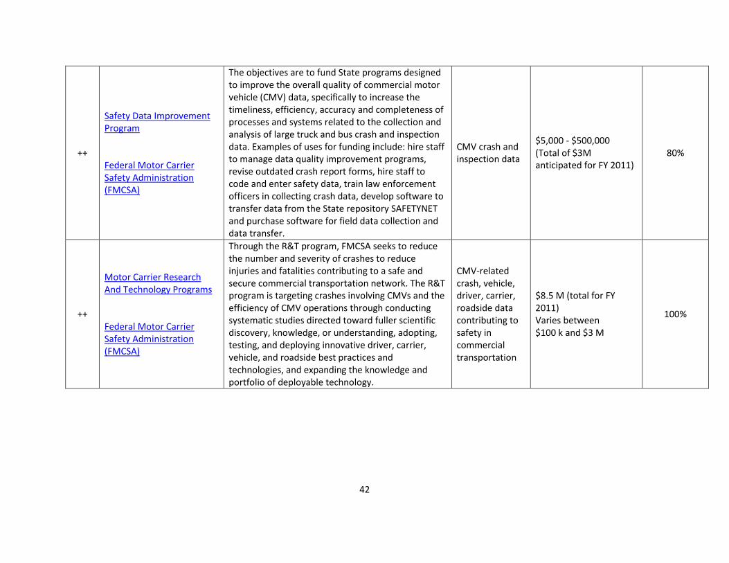
42
++
Safety Data Improvement Program Federal Motor Carrier Safety Administration (FMCSA)
The objectives are to fund State programs designed to improve the overall quality of commercial motor vehicle (CMV) data, specifically to increase the timeliness, efficiency, accuracy and completeness of processes and systems related to the collection and analysis of large truck and bus crash and inspection data. Examples of uses for funding include: hire staff to manage data quality improvement programs, revise outdated crash report forms, hire staff to code and enter safety data, train law enforcement officers in collecting crash data, develop software to transfer data from the State repository SAFETYNET and purchase software for field data collection and data transfer.
CMV crash and inspection data
$5,000 - $500,000 (Total of $3M anticipated for FY 2011)
80%
++
Motor Carrier Research And Technology Programs Federal Motor Carrier Safety Administration (FMCSA)
Through the R&T program, FMCSA seeks to reduce the number and severity of crashes to reduce injuries and fatalities contributing to a safe and secure commercial transportation network. The R&T program is targeting crashes involving CMVs and the efficiency of CMV operations through conducting systematic studies directed toward fuller scientific discovery, knowledge, or understanding, adopting, testing, and deploying innovative driver, carrier, vehicle, and roadside best practices and technologies, and expanding the knowledge and portfolio of deployable technology.
CMV-related crash, vehicle, driver, carrier, roadside data contributing to safety in commercial transportation
$8.5 M (total for FY 2011) Varies between $100 k and $3 M
100%
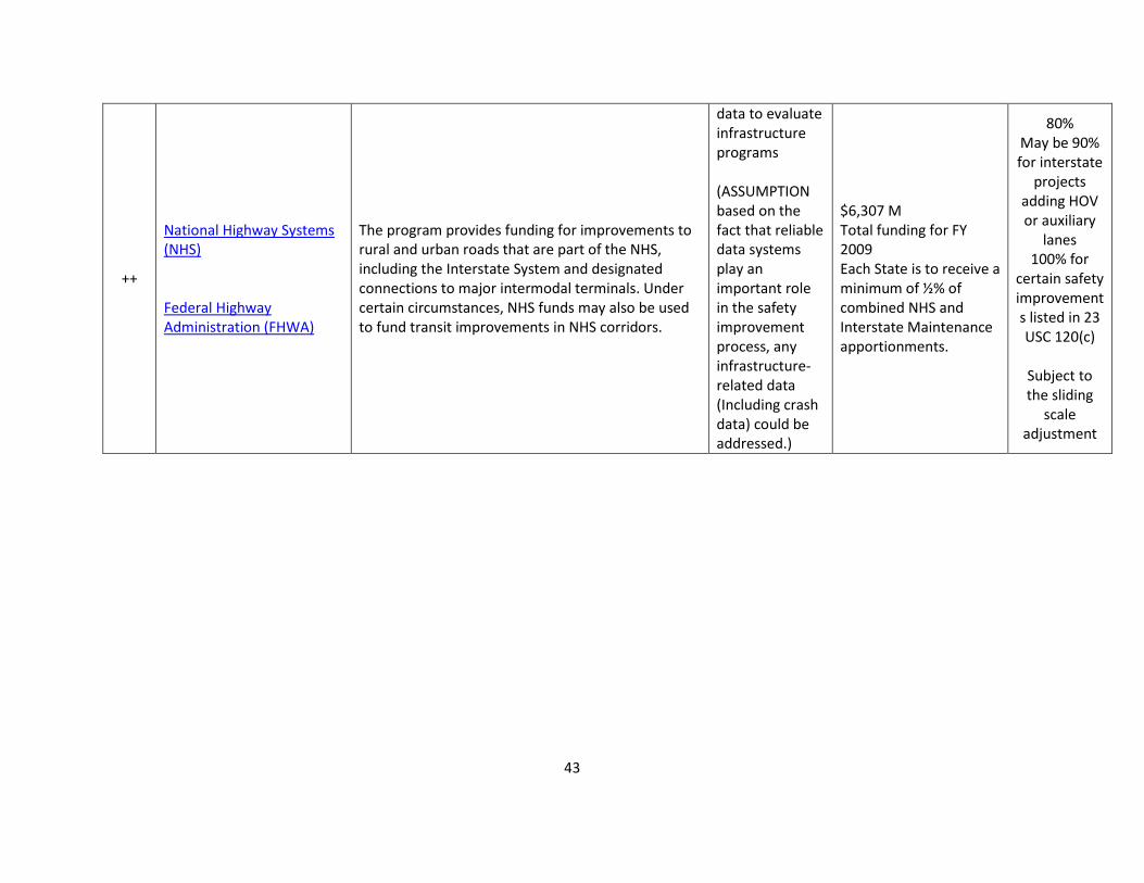
43
++
National Highway Systems (NHS) Federal Highway Administration (FHWA)
The program provides funding for improvements to rural and urban roads that are part of the NHS, including the Interstate System and designated connections to major intermodal terminals. Under certain circumstances, NHS funds may also be used to fund transit improvements in NHS corridors.
data to evaluate infrastructure programs (ASSUMPTION based on the fact that reliable data systems play an important role in the safety improvement process, any infrastructure-related data (Including crash data) could be addressed.)
$6,307 M Total funding for FY 2009 Each State is to receive a minimum of ½% of combined NHS and Interstate Maintenance apportionments.
80% May be 90% for interstate
projects adding HOV or auxiliary
lanes 100% for
certain safety improvements listed in 23 USC 120(c)
Subject to the sliding
scale adjustment
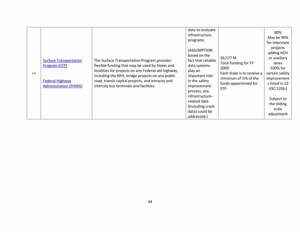
44
++
Surface Transportation Program (STP) Federal Highway Administration (FHWA)
The Surface Transportation Program provides flexible funding that may be used by States and localities for projects on any Federal-aid highway, including the NHS, bridge projects on any public road, transit capital projects, and intracity and intercity bus terminals and facilities.
data to evaluate infrastructure programs (ASSUMPTION based on the fact that reliable data systems play an important role in the safety improvement process, any infrastructure-related data (Including crash data) could be addressed.)
$6,577 M Total funding for FY 2009 Each State is to receive a minimum of ½% of the funds apportioned for STP.
80% May be 90% for interstate
projects adding HOV or auxiliary
lanes 100% for
certain safety improvements listed in 23 USC 120(c)
Subject to the sliding
scale adjustment

45
++
Performance and Registration Information Systems Management (PRISM) Federal Motor Carrier Safety Administration (FMCSA)
The Performance and Registration Information Systems Management (PRISM) program was developed to meet the challenge of reducing the number of commercial vehicle crashes of a rapidly expanding interstate carrier population. It has increased the efficiency and effectiveness of Federal and State safety efforts through a more accurate process for targeting the highest-risk carriers, which allows for a more efficient allocation of scarce resources for compliance reviews and roadside inspections. The PRISM program requires that motor carriers improve their identified safety deficiencies or face progressively more stringent sanctions up to the ultimate sanction of a Federal Out-of-Service order and concurrent State registration suspensions. The PRISM program has proven to be an effective means of motivating motor carriers to improve their compliance and performance deficiencies.
CMV driver, vehicle and crash data (ASSUMPTION based on the description referring to reducing the number of commercial vehicle crashes)
$5,000,000 (total per year 2005-2009)
100%

46
++
Motor Carrier Safety Assistance Program (MCSAP) Federal Motor Carrier Safety Administration (FMCSA)
To reduce the number and severity of accidents and hazardous material incidents involving commercial motor vehicles by substantially increasing the level and effectiveness of enforcement activity and the likelihood that safety defects, driver deficiencies, and unsafe carrier practices will be detected and corrected.
Any data that can be used for CMV safety improvement (ASSUMPTION based on the description referring to reduce the number and severity of accidents and hazardous material incidents involving commercial motor vehicles)
$215 M for FY 2011 Not less than 0.44 percent or more than 4.94 percent of available funds for basic program grants. U.S. Territories may receive a fixed amount of $350,000.
80%
++
Commercial Vehicle Information Systems and Networks Federal Motor Carrier Safety Administration (FMCSA)
The Commercial Vehicle Information Systems and Networks (CVISN) Program is a key component of the Federal Motor Carrier Safety Administration’s (FMCSA) drive to improve commercial motor vehicle safety. The goals and objectives for the CVISN program include improvement of highway safety by enabling safety inspectors to target resources on the high risk carriers, drivers, and vehicles. These changes are expected to reduce the frequency and severity of accidents that involve commercial vehicles.
CMV driver, carrier and vehicle data (number of axles, load weight, etc.)
$100,000 to $2,500,000 50%

47
++
Occupant Protection Incentive Grants (Sec 405) National Highway Traffic Safety Administration (NHTSA)
To encourage States to adopt effective programs to reduce highway deaths and injuries resulting from individuals riding unrestrained or improperly restrained in motor vehicles.
Seat belt/restraints usage data Medical data related to seat belt/restraints (ASSUMPTION based on the description/objectives)
Varies per State: $156,643 to $3,011,640
75% - 1st and 2nd years
50% 3rd and 4th years
25% 5th and subsequent
years
++
Safety Belt Performance Grants (Sec 406) National Highway Traffic Safety Administration (NHTSA)
Increase safety belt use by encouraging States to enact and enforce primary safety belt laws. A primary safety belt law permits law enforcement officers to stop and cite motorists for failing to wear safety belts without requiring that some other motor vehicle violation first be observed.
Seat belt/restraints usage data Medical data related to seat belt/restraints (ASSUMPTION based on the fact that safety program needs data to support the diagnosis and evaluation of treatment)
Varies per State: $165,441 to 38,504,000
100%

48
++
Alcohol Traffic Safety and Drunk Driving Prevention Incentive Grants (Sec 410) National Highway Traffic Safety Administration (NHTSA)
The purpose of this program is to provide incentive grants to states that implement effective programs to reduce traffic safety problems resulting from impaired driving.
Enforcement/offenses data re: alcohol Medical data (More: see Eligibility and Requirements) ASSUMPTION based on the fact that safety program needs data to support the diagnosis and evaluation of treatment)
Varies per state: $972,388 to $17,973,219 Values for FY 2010
100%
++
Motorcyclist Safety Grants (Sec 2010) National Highway Traffic Safety Administration (NHTSA)
The purpose of this program is to provide grants to states that adopt and implement effective programs to reduce the number of crashes involving motorcyclists.
Any data that can be used for motorcycle safety improvement (ASSUMPTION that any data that support reduction of motorcycle crashes)
$100,000 - $483,000 100%

49
++
Border Enforcement Grants Federal Motor Carrier Safety Administration (FMCSA)
To ensure motor carriers operating commercial vehicles entering the United States from a foreign country are in compliance with commercial vehicle safety standards and regulations, financial responsibility regulations and registration requirements of the United States, and to ensure drivers of those vehicles are qualified and properly licenses to operate the commercial vehicle.
CMV driver and vehicle data (ASSUMPTION based on the description referring to drivers qualified and properly licensed)
$32,000,000 (total per year)
100%
++
Commercial Driver License State Programs Federal Motor Carrier Safety Administration (FMCSA)
To achieve the goals of SAFETEA-LU and the FMCSA mission of reducing the number and severity of crashes, fatalities, and injuries involving large trucks and buses by ensuring that States comply with the Federal Motor Carrier Safety Regulations related to commercial driver’s license testing, issuance, and disqualification.
CMV and Bus driver, crash, vehicle and road data (ASSUMPTION based on the description referring to reducing the number and severity of crashes, fatalities, and injuries involving large trucks and buses)
$15,000 - $1,500,000 100%

50
++
Commercial Drivers License Information System Federal Motor Carrier Safety Administration (FMCSA)
To modernize the Commercial Driver's License Information System (CDLIS). Following modernization CDLIS will: (1) comply with applicable Federal information technology security standards; (2) provide for the electronic exchange of all information including the posting of convictions; (3) contain self auditing features to ensure that data is being posted correctly and consistently by the States; and (4) integrate the commercial driver's license and the medical certificate.
CMV driver , conviction, medical data
$15,000 - $1,500,000 80%
+
Child Safety and Child Booster Seats Incentive Grants (Sec 2011) National Highway Traffic Safety Administration (NHTSA)
The purpose of this grant program is to encourage states to enact and enforce booster seat laws.
Child restraint usage data Medical data related to Child restraint (ASSUMPTION based on the description as there is a need for data to assess and enforce seat belts)
Varies per state: $81,337 to $1,157,552 Values for FY 2010
100%

51
+
Racial Profiling Prohibition (Sec 1906) National Highway Traffic Safety Administration (NHTSA)
Encourage States to enact and enforce laws that prohibit the use of racial profiling in the enforcement of traffic laws on Federal-aid highways, and to maintain and allow public inspection of statistics on motor vehicle stops. Eligible states may use grant funds to: - Collect and maintain data on traffic stops - Evaluate the results of the data - Develop and implement programs to reduce racial profiling (including law enforcement training programs) - Undertake activities to comply with the basic requirements of the grant program - Undertake any activities relating to enacting and enforcing a law and collecting data on traffic stops
Driver- and vehicle-related data on traffic stops
Varies per year: $454,570 to $885,460
100%

STATE DATA CAPABILITIES ASSESSMENT FINAL REPORT
53
APPENDIX E – EXAMPLE “WHERE DOES MY STATE STAND?”

3
4
4
4
4
4
3
3
3
4
5
3
2
3
4
2
4
2.6
3.3
3.7
3.8
3.5
3.5
3.4
3.9
2.8
3.6
4.0
3.1
2.4
2.9
3.0
3.6
3.6
0 1 2 3 4 5
1A: Completeness
1B: Timeliness
1C: Accuracy
1D: Uniformity / Consistency
2A: Network Screening (Data)
2A: Network Screening (Method)
2A: Network Screening (Coverage)
2B: Diagnosis
2C: Countermeasure Selection
2D: Evaluation
2E: Accessibility
3A: People
3B: Policies
3C: Technology
4A: Data Interoperability
4B: Expandability
4C: Linkage
Capability Level
Data
Cap
abili
ty E
lem
ent
Where does my State's Roadway Safety Data Capability Stand?
Capability Level National Average

Appendix F: Summary of Preliminary National Actions
The following bullets summarize the key actions to consider to move the National Roadway
Safety Data Capability forward into the next decade:
Conduct case studies to move cost-effective, accurate, and innovative data collection practices forward. States need examples of how to fund, process and extract roadway inventory items.
Pilot and conduct case studies to demonstrate a robust process for States to include locally owned roadway safety data.
Develop a best or noteworthy practices guide for collecting intersection inventory, curve and grade data
Research a priority list of data elements to improve accuracy through external verification and validation.
Continue to develop training for non-technical users in support of the use of the HSM methods and more rigorous analysis methods (e.g., empirical Bayes method).
Develop advanced training and support in SafetyAnalyst to diagram data input needs.
Develop a best practices and/or peer exchange related to data analysis tools and techniques at the State and National level.
Develop a return on investment to provide additional guidance related to collecting inventory and traffic data on local roads with very low crash histories. The research would determine the value and provide guidance as to where it is beneficial.
Conduct pilots and case studies to see how effective data governance is at saving lives and preventing serious injuries from motor vehicle crashes. The case studies should study highly ranked data governance States and contrast them to States with lower levels.
Develop a common glossary of terms and training for safety professionals to understand IT terminology and vice versa.
Develop guidance on structuring or integrating data from various agencies and sources into a comprehensive data clearinghouse.
Develop guidance on expectations for roadway safety data to be made available to the public and shared between agencies.
Pilot linking citation, injury, and driver data to other safety data to determine what the safety benefits may be.
In order to get better analysis and to support the FHWA Focused Approach to Safety, intersection, roadside, and pedestrian data are necessary for these targeted areas. Therefore, a future focus area might include safety data to support the Focused Approach to Safety.
Provide National roadway safety data training modules to enhance the program’s visibility, consistency, and effectiveness
Update assessments every 4 to 5 years to chart progress of the baseline capability of each State and the Nation.

For More Information:http://safety.fhwa.dot.gov/rsdp/
FHWA, Office of SafetyHeather [email protected]
FHWA-SA-12-028