university of arkansas · is the flagship campus of the university of arkansas system. located in...
TRANSCRIPT

Signage and Wayfinding Master Plan
20 October 2005
© 2005
University of Arkansas

2
University of Arkansas Signage and Wayfinding Master Plan
© 2005
This signage and
wayfinding master plan
was prepared for
Martin/Alexiou/Bryson
by Cloud Gehshan Associates.
20 October 2005

3
University of Arkansas Signage and Wayfinding Master Plan
© 2005
Introduction
Survey of Current Conditions
Stakeholder Involvement
Existing Signage
Needs Analysis
The Visitor Experience
The Americans with Disabilities Act
Recommendations and Goals
Identity, Logo and Influences on Graphic Design
Wayfinding Approach
Sign Type Descriptions
Vehicular Sample Journey
Sign Location Plan
Message Schedule
Supporting Information
Signage Location Criteria
Visitor Information Location Plan
Implementation Budget
Table of Contents
4
5
6
11
13
14
15
16
20
29
30
33
37
38

4© 2005
University of ArkansasSignage and Wayfinding Master Plan
Introduction
Nestled among the foothills of the Ozark Mountains is the flagship campus of the University of Arkansas system. Located in the college town of Fayetteville, the “Athens of the Ozarks,” the University is experiencing significant growth, in part due to the region’s recent population increases and a rigorous economy (Wal-Mart’s headquarters is located due north). In an effort to adequately plan for this growth and to address available land resources and a limited transportation system, the University has undertaken the development of a Transportation Master Plan.
The traffic engineering firm of Martin/Alexiou/Bryson (M/A/B) was hired by the University to prepare the Transportation Master Plan, which will be used in tandem with the update of the 1988 Campus Master Plan (concurrently undertaken by the University staff ).
The graphic design firm of Cloud Gehshan Associates was hired by M/A/B to prepare this Signage and Wayfinding Master Plan, which will identity signage and information needs and provide recommendations for the eventual design and implementation of a wayfinding and information system for the campus.

5
University of Arkansas Signage and Wayfinding Master Plan
© 2005
Survey of Current Conditions
Stakeholder InvolvementOver a period of several months, Cloud Gehshan As-sociates collected information by meeting with select staff, faculty, and students (due to project schedule and timing of trips, many students were not available). Other stakeholders included neighborhood, city and business representatives, and the Arkansas Highway and Trans-portation Department.
Documentation of the findings included: photo documen-tation of existing conditions, field observation of univer-sity operations, interviews with the above stakeholders and a videotape of major routes to the campus and city. Many thanks to the dedicated staff of the University of Arkansas for their assistance and invaluable information and to the helpful staff of M/A/B.

6
University of Arkansas Signage and Wayfinding Master Plan
© 2005
Existing Signage
Gateways
Gateway signs for the southern entry to campus are located
along Sixth Street at Razorback Road and Garland Avenue,
and for the eastern entry at Dickson Street and Arkansas
Avenue. No gateway signs exist for the north entry to campus
along Garland Avenue, and a residential neighborhood with
little traffic lies beyond the western edge of campus.
The Sixth Street signs consist of curved (convex) three-
foot high brick walls with bronze lettering. Lack of contrast
between the lettering and brick makes it difficult to read,
particularly on a cloudy day. Current planting of low (1.5
ft.) manicured shrubs in front of the signs require regular
maintenance; a planting of low ground cover, prostrate
shrubs or annuals (less than 1 ft.) would be better suited and
prevent potential concealment of the sign message.
At Dickson Street and Arkansas Avenue, two gateways exist.
The first is a pavement painting of the University mascot in
the middle of the intersection. Giving evidence to University
spirit and athletic pride, the image is hard to read and is
in need of fresh paint or cleaning. The second sign, bronze
letters and panels on an historic perimeter retaining wall, is
hard to read due to materials used and follows the angle of
the stonewall. This low sign (1.5 – 3.5 ft.) is close to the road
(Arkansas Avenue) and is often obstructed by stopped traffic.
Cumbersome ground lighting detracts from the sign.
I T E M / D E S C R I P T I O N / P H O T O C O M M E N T S / I S S U E S
Sixth Street and Garland Ave
Arkansas and Dickson
Razorback Road and Sixth Street

7
University of Arkansas Signage and Wayfinding Master Plan
© 2005
Existing Signage (continued)
Vehicular Directional & Regulatory
At present there are few directional signs for motorists or
pedestrians. The few permanent vehicular signs that exist
are single signs that do not provide a continuous route for
motorists, and are difficult to read (all caps, letters close
together) and poorly placed (at the intersection instead
of before it). Vehicular signs are needed to provide clear
instruction for the visitor in locating parking facilities,
campus buildings, athletic and entertainment venues, visitor
information, Office of Admissions, and for exiting the campus.
There is a prolific number of parking and transit signs, which
often interfere with each other and create confusion. Signs are
difficult to read (font and layout) and sized too small to carry
their message.
I T E M / D E S C R I P T I O N / P H O T O C O M M E N T S / I S S U E S

8
University of Arkansas Signage and Wayfinding Master Plan
© 2005
Existing Signage (continued)
Building Identification – Wall-mounted
I T E M / D E S C R I P T I O N / P H O T O C O M M E N T S / I S S U E S
Mostly consisting of dimensional pin-mounted letters, wall-
mounted building identification signs exhibit inconsistent
graphic standards: dissimilar typefaces, letter height and
spacing, colors and materials. More careful consideration
needs to be given the sizing of letter heights relative to the
architecture of the building.
Identification signs are placed more consistently in relation
to the street than to the building entrance. Given that most
buildings do not have adjacent parking, this appears to miss
the most frequent user of the signs: pedestrians. This is
exacerbated where the buildings are either set far back from
the street or do not clearly indicate through their architecture
where the entrance is located. For nighttime users, signs lack
illumination, making it difficult to locate buildings during
evening hours of operation.
The location of accessible entrances is not adequately or
consistently identified on building identification signs.
Four-letter building codes are in use by the University and are
given to students on schedules and shown on maps. Yet they
are not present on building identification signs where they
would match up with the schedule and map information.
Building identification signs use the formal building donor
names, which are often too long and make for larger and
difficult-to-read signs. Line breaks are particularly problematic
in making for difficult to read signs. All of this adds "noise"
to the sign system, making the user work much harder than
necessary to find their destination.
9
University of Arkansas Signage and Wayfinding Master Plan
© 2005
Existing Signage (continued)
I T E M / D E S C R I P T I O N / P H O T O C O M M E N T S / I S S U E S
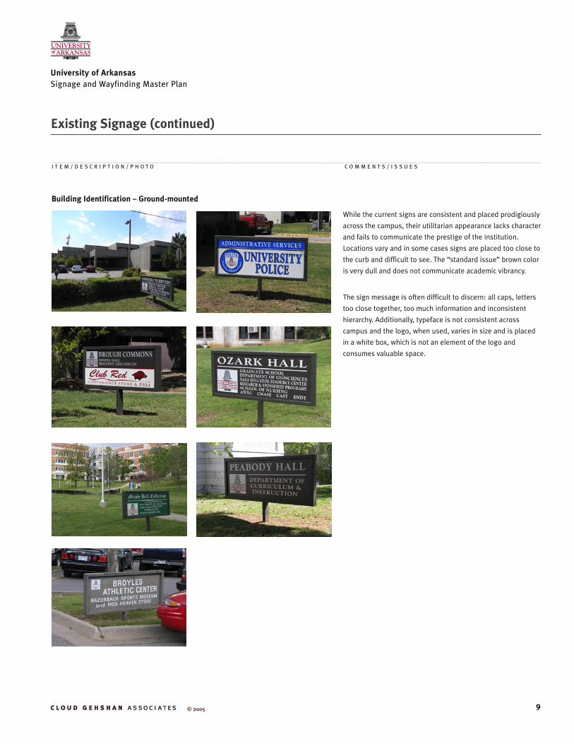
Building Identification – Ground-mounted
While the current signs are consistent and placed prodigiously
across the campus, their utilitarian appearance lacks character
and fails to communicate the prestige of the institution.
Locations vary and in some cases signs are placed too close to
the curb and difficult to see. The “standard issue” brown color
is very dull and does not communicate academic vibrancy.
The sign message is often difficult to discern: all caps, letters
too close together, too much information and inconsistent
hierarchy. Additionally, typeface is not consistent across
campus and the logo, when used, varies in size and is placed
in a white box, which is not an element of the logo and
consumes valuable space.

10
University of Arkansas Signage and Wayfinding Master Plan
© 2005
Existing Signage (continued)
I T E M / D E S C R I P T I O N / P H O T O C O M M E N T S / I S S U E S
Visitor Information
At present there are few, if any, directory maps on or off
campus. Maps on campus consist of locator maps for the
“Senior Walk,” but fail to communicate the level of detail
needed for adequate campus orientation and accessibility
information.
Brochure maps for parking and a visitor’s guide are available
as printed material. The location of accessible entrances is
indicated on both; however, the level of detail is different.
Detail size and form on both could be problematic for those
with visual impairments.
During the research phase of this master plan, a new
electronic kiosk was installed at the University Bookstore
located five miles north of campus, with plans to install
another at the Harmon Avenue Parking Facility in the fall of
2005. The kiosk consists of a 40” plasma screen above a touch
screen, and a phone. Connected to a printer by the store cash
register, the kiosk has the ability to print directions to campus,
campus and parking maps, senior walk map, bus routes,
campus and building directories. The phone provides direct
voice contact with departments and activities on campus.

11
University of Arkansas Signage and Wayfinding Master Plan
© 2005
Needs Analysis
An effective sign program stems from addressing the needs of an institution’s audience. Across the board, those who use the University of Arkansas campus require unambiguous and up-to-date direction to and from facilities, identification of facilities, appropriate entrance information, units and services located within a particular facility, and street addresses. The following outlines specific needs of current user groups.
Staff and Students • As frequent or regular users this group needs
information about changes or detours to established routes.
• Directional information is needed for new students and staff and for occasions when they must go to novel or infrequently used locations.
• Names of parking facilities take on particular importance as the first stop for most users. In multi-story parking structures or large surface lots, area and floor designations are important when users park in different locations each time.
• Clear parking operation signs. This will include permitted users, hours of operations, and special conditions.
• Identification of multiple entrances to buildings.• Clear building names. Names that directly convey
a unique identifier as well as function are most desirable. Even long-time staff need to find new or little used facilities.
• Building Code designations. Building codes used for schedules and on maps need to be clearly identified at the physical facility to be of use to visitors, students, staff, and faculty. The building code system should be consistent and remain constant over time.
• For the foreseeable future, most buildings are accessed on foot as they are not adjacent to parking. Thus, sign locations need to take into account the paths and sight lines of pedestrians as primary users with exceptions where general parking is adjacent to facilities.
• Identification of units and facilities within buildings. Where multiple units share buildings, or where service offices (e.g., copying) are located within a facility it needs to be indicated on building identification signs where space allows.
Visitors• Have the same needs as staff and students but as
first time or irregular users they need to see the information more frequently and, preferably, have it to take with them in order to facilitate memory for directions and locations.
• Visitors will also benefit from information available to them prior to setting out on their travel to the University. Information that is mailed or accessed via the Internet is important.
• Detour information is important for visitors, particularly repeat visitors. However, with their limited experience of campus it will have the same salience as other directional information.
Special User Groups: Disabled• Clear designation of accessible parking for motorists.• Clear designation of main/accessible entrances for
drop-off of disabled passengers.• Clear designation of accessible routes where these
vary from standard access paths. This will be particularly important where topography varies.
• Clear designation of accessible entrances.• Designation of particular access to units within the
building. For the disabled it will be important to note where access to specific units within the building is possible if it is not universal.
• Type font, size and sign location allow for close inspection of signs for those with movement and sensory limitations. ADA requires a minimum 5/8" cap height for sign lettering for accessible signs.
Elderly• Similar needs to disabled and regular users.• Elderly have stronger motivation to seek confirmation
of directions than other user groups. The availability of someone to answer questions, either in person or on the phone, is desirable.
• Elderly alumni can have more difficulty than other visitors on infrequent trips to campus due to their pre-conceptions as how the campus looks and operates that may be incorrect and out-of-date.
• Elderly will also need more frequent reiteration of directional information or available hard copy information to carry with them to offset memory limitations.

12
University of Arkansas Signage and Wayfinding Master Plan
© 2005
• Elderly will also have more difficulty with graphic materials and detail due to common visual limitations.
• Higher illumination on signs during non-daylight hours and at dusk and dawn is required.
Event Attendees• Similar needs to disabled and regular users.• Clear directions from parking to venues and back.
Facilities/Maintenance StaffFacilities and Maintenance staff have different requirements from other users discussed. For them the issue is not how to get somewhere but rather what goes on signs, how they are fabricated and installed, and how they can be repaired and updated.* They need a system that allows for flexibility where changes are likely and resistance to the stresses of incidental damage and vandalism. Needs include:• A system that has a limited number of components
to minimize types of parts that must be kept on hand for repairs or replacement.
• A system with sufficient structural strength to resist incidental vandalism and much deliberate vandalism.
• Sufficiently generic fabrication process to allow for multiple local bidders
• A system that can be cost effectively updated.• Sufficient annual fiscal resources to maintain the
information system with up-to-date information.• Sufficient fiscal resources in construction
budgets for design, fabrication, and installation of signs for all new facility entrances and internal building directories at significant entries (see implementation budget on page 38).
• Database of signs with text and location for regular review of maintenance and information issues.
Emergency Services• Police, fire, EMT and other service personnel
need clear street address and entrance location information to reduce lost time in emergency situations.
• Special use buildings such as laboratories need to alert emergency services personnel to special equipment or hazards within the facility.
• For heavy equipment, such as fire trucks, demarcation of special paths within the campus may be necessary where underground tunnels or other potential hazards exist.
Delivery Personnel • The location of loading docks needs to be clearly
indicated. This is very important when the docks are not located on the same street as the building entrances.
• Street address is important as some delivery services will only deliver to a street address.
*Outsourcing versus In-house Fabrication
Generally, it is recommended that signs be fabricated and
initially painted by an outside vendor. Most universities do
not have the capability or necessary equipment to render a
professional product. Replacement copy for existing signs
can be done in-house, provided the facilities department has
a paint booth – when replacing copy it is often necessary to
re-paint the entire sign as finishes will fade – vinyl cutting
machine and current software (check with manufacturer
of vinyl cutting machine). For replacement of the signs
themselves, it is recommended that “attic” stock be ordered at
the time of original fabrication and stored.
Needs Analysis (continued)

13
University of Arkansas Signage and Wayfinding Master Plan
© 2005
What follows is a general description of the visitor experience, broken down by means of interaction with the University through existing information systems: Pre-Visit InformationRequests for information are typically answered by referring the individual to the University web site. General directions to the campus are good, but the map should be revised. The listing of building codes on the University web site with the campus map is very difficult to read at present and there is not a corresponding list by building name. The level of visual detail could stand improvement. An overall key map showing satellite campus locations in relation to the main campus would also be helpful.
Additional map comments: 1. Use less axonometric detail to avoid obscuring paths and other features. Only important/identifiable buildings should be represented this way.2. The parking garages should be shown in the same color as public parking.3. Listings should be by sign names, not formal names.4. Do not alphabetize by codes; most visitors are looking for a location rather than trying to identify unknown buildings.5. Some indication of large topographic changes is desirable, but it must be constrained so as not to obscure paths or buildings.
MotoristsThe campus has access from the north along Garland Avenue and from the south there is a spine along Razorback Road where several sports facilities are located. There is no street grid within the campus for motor vehicles, thus motorists’ experience of the University is at the edge of campus on the west, north and east. Dickson Street does penetrate into the campus from the east but dead ends from the user’s perspective at Garland. The south side of campus lacks an experiential edge and appears to trail off into a wooded residential area. A visitor does not get a view of the campus from the south with the exception of what can be seen at 6th Street and Razorback Road.
ParkingParking on campus is complicated, with existing signs having complex messages that are difficult to read. In part this reflects the complex set of rules for campus parking, however layout and organization of the signs themselves adds to the difficulty and will frustrate and deter visitors. In addition, the two major parking structures on the campus pose additional barriers to visitor use. The Inter-Modal Transit Facility (from the Visitor’s guide maps) or Garland Parking & Transit Facility (as shown on the 04-05 Parking Map which also refers to it as a deck) is not accessible from Garland as the street is closed to traffic. This is bound to be confusing to visitors and newcomers. The new Harmon Avenue Parking Facility is located on the southern edge of campus where access roads are neither clear nor easy for new users, wending their way through an apparent residential area unrelated to the campus.
PedestriansFrom the pedestrian perspective there is a central campus defined by the plateau that encompasses the majority of academic buildings. There is also a large residence hall district to the northwest and at the southwest edge of the plateau and below. The topography of the campus creates limitations to access from the west and south. This is particularly acute for those with disabilities and older adults.
On-campus pedestrian signs exist as building identification signs that are difficult to read due to design and organization. Building identification is limited to main entries which may, or may not face direction of significant traffic flow, pedestrian or otherwise. Directional signs and directory maps are lacking.
DisabledFor the disabled, partial information exists in the form of occasional accessible entry information, but there is a lack of a network of information to guide the disabled effectively. There is at least one accessible route sign but no indication of what is accessible from the route. At buildings there is a lack of accessibility information at entrances. A map of accessible entries does exist on the Center for Students with Disabilities website of the University but is not linked to visitor information.
The Visitor Experience

14
University of Arkansas Signage and Wayfinding Master Plan
© 2005
The Americans with Disabilities ActThe Americans with Disabilities Act was signed into Law in July 1990. This historic act was designed to provide equal access and opportunities to all Americans with disabilities, a constituency which, in the context of the ADA’s broad definition, presently accounts for approxi-mately 50% of the population.
In order to produce an ADA-friendly signage system, which will make the campus more accessible to the disabled, the design and manufacturing of the signage should adhere to proper ADA standards.
For more detailed information please refer to the ADA White Papers. Available from:
Society for Environmental Graphic Design1000 Vermont Ave., Suite 400Washington, DC [email protected]

15
University of Arkansas Signage and Wayfinding Master Plan
© 2005
The graphic identity of an institution should be appropriate to the stature of the institution. It should be memorable to those who encounter it, easy to understand, and able to be successfully applied to the widest range of mediums. Creating an identity involves both discovery and invention, looking backward and forward; it should inspire as well as represent.
University of Arkansas is a growing liberal arts institution, with a nationally respected agricultural research facility and ranking school of business (among the nation’s top ten); as such, its identity should reflect this vitality and achievement. Identity language currently found on campus – traditional or simple typeface, use of images such as shields, ribbons or laurel wreathes – should be encouraged. Refined but dynamic shapes and rich colors provide appropriate visual context, communicating academic professionalism and vitality without being overly corporate.
The logo, the graphic signature of an institution, often incorporates school colors, the institution name, and a visual element that has achieved a measure of recognizability, such as an historic building on campus or a school mascot. The logo can also be a wordmark, which is the graphic depiction of the institution name in a specified typeface and spatial arrangement.
Currently, there are two logos in use by University of Arkansas: the horizontal line illustration of the bell tower and university name (primary logo), and the collegiate seal with Latin motto and the Old Main building. The razorback – wild boar of the region – is the university mascot; the official school colors are “razorback red,” black and white. As part of a comprehensive graphic design project, the University may want to undertake the design of a new logo that will have successful and universal application when used in signage, architectural inscription and small scale print projects.
Understanding the contextural language of an institution is the first step in designing a graphic system. These design influences include: campus architecture – its shapes, forms, colors and decorative elements; predominating or unusual features of the landscape; the urban or rural setting of the campus; the institution’s history; and, anything specific or unique to the institution. A thorough process to understand and catalog such elements will prove invaluable to the graphic designer, and indeed the institution, when embarking on the development of a graphic identity.
Identity, Logo and Influences on Graphic Design

16
University of Arkansas Signage and Wayfinding Master Plan
© 2005
Wayfinding Approach
A signage plan provides for multiple levels of visitor information, site and destination identification, vehicular and pedestrian direction. These recommendations should form the basis for the development of a comprehensive set of design guidelines.
University of Arkansas:1. Provide motorists with guidance information from
major roadways to the Fayetteville area (I-540) as well as from the regional airport using trailblazer signs and highway guidance signs.
2. Direct visitors in to the campus along Razorback Road from the south and Garland Avenue from the north using directional signs and trailblazers. From the south the approach along Razorback provides the visitor with many cues to the institutional identity through the venues along the route. These should be reinforced with additional visual devices, such as uniform streetscape fixtures and sidewalk furnishings.
3. Direct visitors to a central information center on the campus where they can get information about the University, parking information and permits, maps and other information that they can take with them. This should be a staffed site in order to accommodate the greatest range of information needs and requests. Staffing should be supplemented with fixed maps, information brochures, and electronic information kiosks at the site.
Recommended locations for the central information center include the Intermodal Transit Facility Garage (recommended name: “Stadium Drive Garage” – see page 18) or in the adjacent Student Union. Benefits of these locations include: convenient access to core campus locations – academic and athletic, convenient access to transit, visitors will have visual contact with the main campus along the arrival route, adjacent to university-related retail locations, easily accessible from both Razorback and Garland entry routes, convenient and sheltered parking.
Consideration should be given to parking space availability for these locations (as determined by campus policy). A small number of dedicated short-term parking spaces (3 or 4 spaces; 30 minutes or less) for visitors would be needed.
Additional un-staffed information stations should be placed on vehicular and pedestrian approaches to campus, at parking facilities, and within the campus. All kiosks should have information that visitors can take with them and indicate a phone number to call in order to talk to a live person.
4. Once on foot on campus visitors and other users should encounter a network of pedestrian signs and information kiosk/directory maps that provide general orientation and major destination information. This includes getting visitors back to parking locations and identifying accessible building entrances.
5. The campus map should be refined to provide clearer and more consistent information including identifying what is within a 5-10 minute walking distance of the location.
Fayetteville DowntownDowntown Fayetteville can best be described as two areas within easy walking distance of each other. Separated by only three blocks and by types and time of use, Dickson Street is commercial entertainment in character while The Square is institutional and governmental in character. 1. For downtown Fayetteville, use Dickson Street
as the initial destination and direct people to The Square from Dickson Street.
2. Provide trailblazers along major routes into downtown to “Fayetteville Downtown.” If used in conjunction with University directions, use a directional sign rather than two trailblazers to avoid confusion.

17
University of Arkansas Signage and Wayfinding Master Plan
© 2005
It is recommended that the city pick up the university’s system – this maintains a consistent look and feel, and avoids the cost of designing another competing system. On approaches, both the city and university should be listed up to decision points where they split off in different directions. After that, the signs would be the same but the directions would be university of downtown specific as appropriate.
3. Provide un-staffed information kiosks in the Square and along Dickson Street with both university and city maps as static displays and in take-away brochure form.
Facility NamingThe main objective is to provide a scheme for identifica-tion that will provide a unique name for each building, satisfying the needs of both the user and those whose generosity provided resources for the facility. The follow-ing proposed policies are recommended:
Proposed Policy 1 Provide appropriate recognition of donors or patrons within the building. Donors for University buildings or other persons deemed worthy of recognition should have an appropriate place where their contributions can be recognized. The ideal location is in the main lobby of the named building; al-ternate locations would be an important hallway or other area where people congregate. Formal recognition of their contributions must display the full, formal building name. Other details of the individual’s contribution may also be displayed, for instance “In memory of,” or “Given on the 50th anniversary of .......” Depending on the nature of the gift, there could be interpretive information about the donor(s) or programs, or drawings/photos of the individuals. The wall area should be properly lit so the attribution is attractive both day and night.
Proposed Policy 2 Each building has 2 names: a formal name and a short-ened name.The formal name for the building reflects the full name of the donor and facility and should appear in the build-
ing lobby and on official documents; the shortened name will be used in common parlance and on exterior signage. It is preferable for the University to officially establish a shortened name than for the general commu-nity to come up with its own abbreviations or nicknames that may or may not be appropriate The shorter name will also be most helpful for those trying to find the building. Generally speaking, the shortened name elimi-nates first names, middle initials and suffixes.
It is best to avoid having two totally different names for a building (e.g., “Epley Hall” and the “Band Building”) as this will create much confusion for visitors as well as staff creating web or print materials or giving directions.
Existing University of Arkansas Policy for Naming Opportunities (Fayetteville Policies and Procedures 213.1) states that student living and dining quarters be designated “halls” or “commons,” buildings occupied by laboratories as “laboratory,” and buildings occupied by offices and classrooms as “building.”
Proposed Policy 3Buildings that are joined or appear to the casual observer as a single building, should be identified as a single building.When buildings are joined together, or a new structure is appended to an existing building, it appears to the observer that they are entering one facility. Even if the co-joined buildings are given separate names, an over-arching name should be created to match what visitors and others see. It is recommended that a name using the terms “complex” or “center” be employed (note that this will also create another development opportunity for the University). Names of the separate sub-build-ings should be retained and placed appropriately within each of the sub-buildings. At entrances, the name of the sub-building might be displayed along with the center/complex name to reinforce the latter. There is nothing inherently wrong in connecting buildings if there is some coordination with an information system that reflects the hierarchy of the whole.
Wayfinding Approach (continued)

18
University of Arkansas Signage and Wayfinding Master Plan
© 2005
Wayfinding Approach (continued)
Proposed Policy 4Use the shorter building name on buildings and direc-tional signs.Building names on buildings and directional signs need to be short and simple. This helps to avoid problems with line breaks and multi-line names, and keeps the sign face from becoming too large. Building identifica-tion names for signs should use the shortened form referred to previously; it may even be necessary to use abbreviations or shorten names further. Building names should be shown as three or fewer words as outlined below.
Structure of names – buildings should have a “sign” name consisting of:• a shortened name; e.g., Sam Walton, Tyson, Epley• a single facility type, if applicable; e.g., Hall, Building,
Laboratory, Center• a single function identifier; e.g., Chemistry, Arts, Engi-
neering, Science
Vehicular directional signs require the shortest intelli-gible name due to limited driver attention and the speed of vehicles. Typically two words for a building, dropping the first “name word” of the building (e.g., Walton Arts Center on vehicular signs should be “Arts Center” so long as this does not promote confusion with another building).
Proposed Policy 5Make building names as unique as possible.It is inevitable that some buildings will have similar-sounding names, but it should be avoided if possible. For regular users this should not be a problem, although proximity of one to the other will cause difficulties, par-ticularly for newcomers. It is necessary to remember that wayfinding is usually a secondary task, the primary task being a meeting, appointment, class or event. So a build-ing name becomes just one bit of information in a jumble of items, and if a user comes across a building name that looks like another (for example Doan and Dodd Halls), they are as likely to go to one as to the other.
Proposed Policy 6Parking structure names should provide location infor-mation.Parking structures, both lots and garages, are destina-tions for motorists. Names for these should provide some location information to reduce the information load on visitors. The names can reflect well-known, nearby facilities. The most desirable option is one where the name employs the name of the street from which one enters the facility. For example, the Garland Garage is no longer entered from Garland Street, and the name “Inter-modal Transit Facility” gives no indication of its location; therefore, it would better serve the public as “Stadium Drive Garage.” Terms, such as “deck” or “parking facil-ity,” should only be employed if part of the local lexicon.
Visitor InformationStaffed Visitor Information CentersWhen institutional budgets, organizational infrastruc-tures, and space allow, a staffed visitor information center is the most desirable form of first contact with a visitor or prospective student. More often than not, it’s left to the Office of Admissions to fulfill this role, provid-ing necessary application, enrollment, and campus life information, in addition to providing guided interpre-tive tours. Information centers, including de facto ones, should be located close to or on campus and should be accessible to visitor parking and public transportation (when applicable).
Orientation MapsLocated at a staffed information center, information booth, or serving as a stand-alone sign, this useful device is a powerful tool in orienting visitors and other campus users. As a static map, this sign type is able to provide a more complete listing of destinations than is possible with other components of a wayfinding and information system.
Map location criteria include:• At locations where people have room to exit their
cars, stand and read a map• Close to parking, but not so far from destinations that
users forget information

19
University of Arkansas Signage and Wayfinding Master Plan
© 2005
Wayfinding Approach (continued)
• At pedestrian decision points and pedestrian exits from garages and major event venues
• Area that is “safe” and well-lit for night-time use• Ideally, map orientation should change depending on
how sign is oriented
Map components include:• Campus map• “You-are-here” markers on map• Alphabetical list of buildings, keyed to map• Transit information• Accessibility information• Weather-protected slots for take-away maps, etc. • Helpful phone numbers
Electronic KiosksAn extremely useful and technologically up-to-date tool, these devices have the capability of offering the most information of any of the wayfinding and information system components. Location criteria remain the same as orientation maps (all-weather models are available), but the cost in development, implementation and main-tenance time is significantly more.
A number of issues need to be addressed in deciding whether and how to implement an electronic system. What information is to be available and to whom is it directed? Visitors are an obvious audience for directional and event information, but prior experience has shown that other campus users may be a larger audience for event, transit, schedule, and other information. Some of this may already be available on the University web site and could be moved to the kiosk software.
Maintenance of equipment and information has a num-ber of facets that should be addressed:• Who is responsible to develop information for the
system?• Is there staff experienced enough to develop, design,
or at least knowledgeably review the information and computer interface that end users will be using?
• Who will be responsible to gather update information for the system?
• From how many sources will information have to be gathered and how often?
• What form(s) is update information in, and how much effort will be needed to transform it for kiosk soft-ware?

20
Sign Type Descriptions
University of Arkansas Signage and Wayfinding Master Plan
© 2005
1 Vehicular TrailblazersDirects visitors from interstates and neighboring areas to the campus
2 mi.
Ohio State University
• One destination per trailblazer• Directional arrow and distance (in miles) on separate plaque
• “University of Arkansas” or “Fayetteville Downtown”
• UA Logo • As reinforcement along interstates and approaches to campus/town
• As per MUTCD • Multiple trailblazers along a road is not recommended• If 2 or more destinations are needed, use directional signs
Text TerminologySub-components Symbols Locations
LegibilityRequirements Comments

• University of Arkansas
• UA Logo • Major entries to campus:–Razorback atWest 6th–Garland at Maple –Dickson atArkansas –Maple atArkansas
• Visible at 200’ • At each selected location
Text TerminologySub-components Symbols Locations
LegibilityRequirements Comments
2 Gateway IdentificationMarks the entrance to the University of Arkansas andexpresses the identity
21
Sign Type Descriptions (continued)
University of Arkansas Signage and Wayfinding Master Plan
© 2005

• Names limited to 2 words (in most cases)• Name to fit on one line• Use abbrevia-tions as noted in the MUTCD manual
• Destination and facility names• Number of lines limited by vehicle speed• More than 35 mph: 2-3 lines of text• 25-35 mph:3-4 lines of text• Less than 25 mph: 4-5 lines of text
• Parking,Information,Federal, State, & local route symbols
• Signs should be 100-150 feet prior to the intersection (unless there is an intervening intersection)
• From MUTCD 2004: Letters should be at least 150 mm (6 in) in height for all capital letters, with 113 mm (4.5 in) in height for lower case letters• On urban streets with speeds of 25 mph or less, letters should be at least 100 mm (4 in) in height• Font is to be san serif for legibility
• Order of movement: left, right, ahead• Locations listed alphabetically within direction of movement
Text TerminologySub-components Symbols Locations
LegibilityRequirements Comments
• Beyond campus boundaries:Visitor Information,Visitor Parking,Admissions• Within campus boundaries: the above items along with immediately adjacent major destinations & venues at decision points; e.g., Walton Arena, Baum Stadium, Harmon Garage, Music Building
3 Vehicular DirectionalProvides guidance to parking, destinations, receiving areas and exits
22
Sign Type Descriptions (continued)
University of Arkansas Signage and Wayfinding Master Plan
© 2005

• From T&P• Facility name• Street Address• Type(s)of ParkingPermitted• Hours ofOperation
• Parking • At vehicle street entries to parking facilities
• Visible and identifiable at 200’ • Legible in excess of 100’
• At each selected location
Text TerminologySub-components Symbols Locations
LegibilityRequirements Comments
4 Parking IdentificationDesignates parking areas and communicates regulatory policies
23
Sign Type Descriptions (continued)
University of Arkansas Signage and Wayfinding Master Plan
© 2005
T H E O H I O S TAT E U N I V E R S I T Y
PPermit Parking11th Avenue Garage
FULL
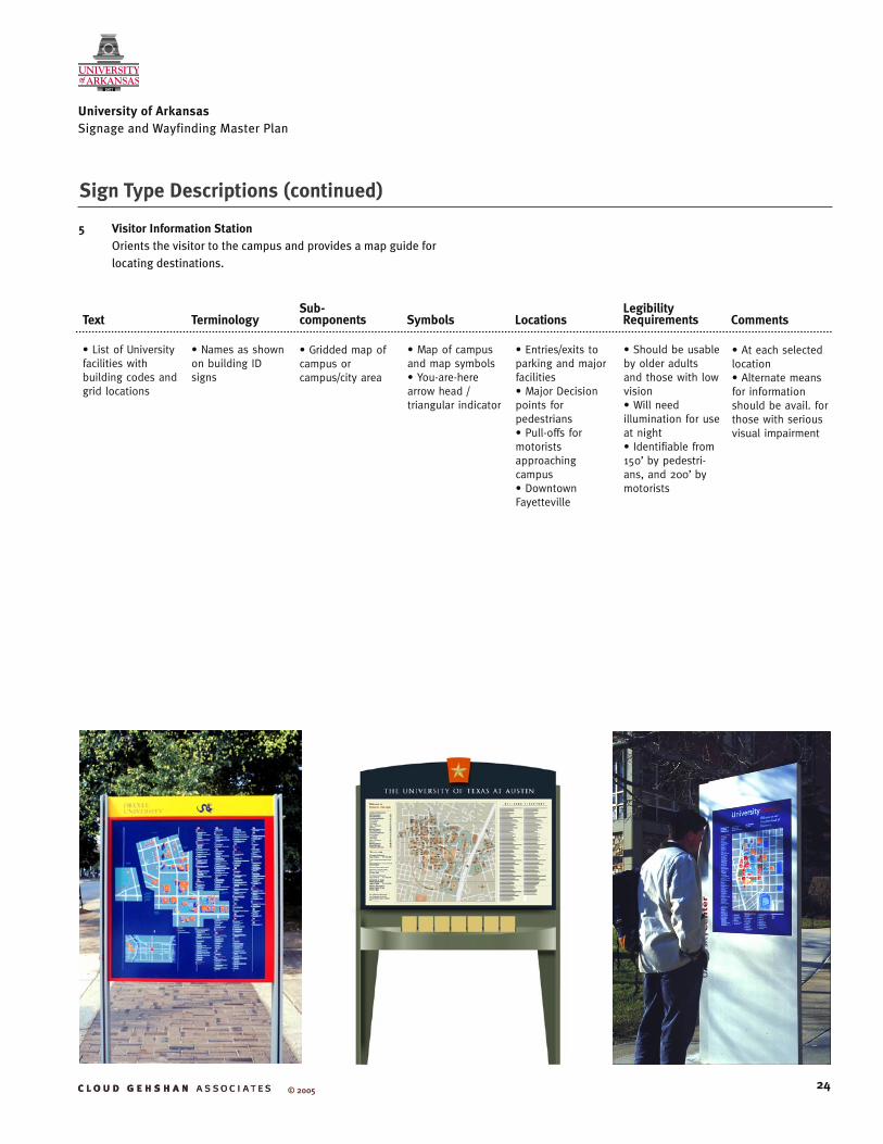
• Names as shown on building ID signs
• List of University facilities with building codes and grid locations
• Map of campus and map symbols• You-are-here arrow head / triangular indicator
• Entries/exits to parking and major facilities• Major Decision points for pedestrians• Pull-offs for motorists approaching campus• Downtown Fayetteville
• Should be usable by older adults and those with low vision• Will need illumination for use at night• Identifiable from 150’ by pedestri-ans, and 200’ by motorists
• At each selected location• Alternate means for information should be avail. for those with serious visual impairment
Text TerminologySub-components Symbols Locations
LegibilityRequirements Comments
• Gridded map of campus or campus/city area
5 Visitor Information Station Orients the visitor to the campus and provides a map guide for locating destinations.
24
Sign Type Descriptions (continued)
University of Arkansas Signage and Wayfinding Master Plan
© 2005

• Limited to 2-3 words • Name to fit on one line• Buildings listed alphabetically
• Sign location (ifat namedintersection)• Parking facilities within 5 min walk• Next street • Major landmarks & destinations• UA local Information Number
• Information• Accessibility• Parking
• At street corners and decision points
• Minimum 5/8” cap height as per ADA
• Subsequent sign should be visible (not readable) where topography permits.• Location should not interfere with disabled movement and should be approachable for close inspection by low vision users
Text TerminologySub-components Symbols Locations
LegibilityRequirements Comments
• Grouped by direction of travel
6 Pedestrian DirectionalProvides guidance to key destinations
25
Sign Type Descriptions (continued)
University of Arkansas Signage and Wayfinding Master Plan
© 2005
Speedway at Tower
SAG
MAI
LBJ
ERC
SJG
TSG
SSB
SWG
MAG
TRG
BRGBMA
Dean Keeton Street
Red
Riv
er S
tree
t
San
Jac
into
Blv
d.
W. 27th Street
Martin Luther King Blvd.
Gua
dal
upe
Stre
et
W. 24th Street
STD
Spee
dw
ay
THE UNIVERSITY OF
AT AUSTIN
Gebauer Bldg GEB
Goldsmith Hall GOL
Guadalupe StreetMain Building & Tower MIA
Natural Sciences WCH
Texas Union UNB
Arts / AthleticsLBJ Library LBJ
Blanton Museum BMA
Brazos Garage BRG
Erwin Center ERC
Hargis Hall / Admissions JHH
Harry Ransom Ctr HRC
Jester Center JES
MLK BoulevardSan Jacinto Res Hall SJH
Trinity Garage TRG
YOUARE
HERE

26
University of Arkansas Signage and Wayfinding Master Plan
© 2005
• One destination per trailblazer with facility name or accessible entry text
• Major event venues; e.g., Stadium, Arts Center• Accessible entrances and routes
• If applicable, limit to symbols that new users will be familiar with• Exception is use of facility logo (if exists)
• Decision points (in the absence of pedestrian directional signs) • Along route from major parking locations to designated destinations• From building entrances to accessible entry
• 100’ visibility, 50-75’ legibility
• Location should not interfere with disabled movement and should be approachable for close inspection by low vision users
Text TerminologySub-components Symbols Locations
LegibilityRequirements Comments
7 Pedestrian TrailblazerGuides visitors along accessible routes
Sign Type Descriptions (continued)
• One destination per trailblazer with facility name and directional arrow
• Bike parking• Major event venues
• Parking; others as appropriate• Limited to symbols that new users will be familiar with
• Along dedicated bicycle paths• Along roadway bicycle lanes• At bicycle path entrances• As possible markings on pathways
• 100’ visibility, 50-75’ legibility
• Approaching decision points • Smaller and different shape from vehicular signs• Located within bicyclists typical field of view (lower than for cars)• Should be consistently placed in locations where they are not confused with vehicular signs
Text TerminologySub-components Symbols Locations
LegibilityRequirements Comments
8 Bicycle TrailblazerGuides visitors along bicycle pathways
27
Sign Type Descriptions (continued)
University of Arkansas Signage and Wayfinding Master Plan
© 2005

• Limited to 3 units: Identifier, Function, Building Type• “Center” if joined multiple buildings, with individual building names listed as subunits• 3 or less words; 4 maximum• Name to fit on one line
• Facility name• Building Code• Street Address• Sub-units ifapplicable & sizepermitting• Accessibleentrance locationas needed
• Accessibility • At primary entrances as well as along all streets bordering facility• Free-standing and wall mount, depending upon conditions• At secondary entrances; location depends upon sight lines
• Sized for pedestrians if no vehicular paths adjacent, otherwise slow moving vehicles (<25mph) • At boundaries and along arterials, sized for posted vehicle speeds
• Location should not interfere with disabled movement and should be approachable for close inspection by low vision users
Text TerminologySub-components Symbols Locations
LegibilityRequirements Comments
• Colleges, units and departments with main administrative office in building only • Limited to 6 lines of text
9 Building Identification (Ground and wall-mounted)Identifies buildings and entrances
28
Sign Type Descriptions (continued)
University of Arkansas Signage and Wayfinding Master Plan
© 2005

29
University of Arkansas Signage and Wayfinding Master Plan
© 2005
03
04 05
0
7 12
15
18
26
21
17
13
20
2224
10
11
14
16
19
08
06
25
27
09
01
02
04
Map
Key
Stre
et
Si
gn
Sig
n F
ace
Ref
Nu
mb
er
NS
W E
© 2004
Vehicular Sample JourneySign Location Plan

30
University of Arkansas Signage and Wayfinding Master Plan
© 2005
ItemNumber Facing
Directional Arrows Message Location
01 East g University of ArkansasFayetteville Downtown
• Exit ramp off I-540 heading north* Alternate: Trailblazer for the University with right arrow
02 South h University of ArkansasFayetteville Downtown
• S Cato Springs Rd* Alternate Trailblazer for the University with straight arrow
03 South g
h
Ark. Research andTechnology Park
University of ArkansasFayetteville Downtown
• Prior to SE corner of S Cato Springs Rd and W Cato Springs Rd
05 South g
h
Fayetteville Downtown
University of Arkansas
• Razorback Rd at 6th Street, SE corner
06 North g
h
I-540 North
I-540 South
• Razorback Rd
07 South f
h
Facilities Management
AdmissionsVisitor Information [information symbol]Visitor Parking [parking symbol]
• Razorback Rd
08 North g
h
Facilities Management
I-540
• Razorback Rd prior to NW corner of Razorback Rd & W Mitchell Sts
09 South g
h
Walton Arena
AdmissionsVisitor Information [information symbol]Visitor Parking [parking symbol]
• Razorback Rd prior to NW corner of Razorback Rd & W Leroy Pond
04 South f
h
Baum StadiumTrack Center
University of ArkansasFayetteville Downtown
• Razorback Rd
Vehicular Sample Journey - Message Schedule
Vehicular Directional Message Schedule
31
University of Arkansas Signage and Wayfinding Master Plan
© 2005
ItemNumber Facing
Directional Arrows Message Location
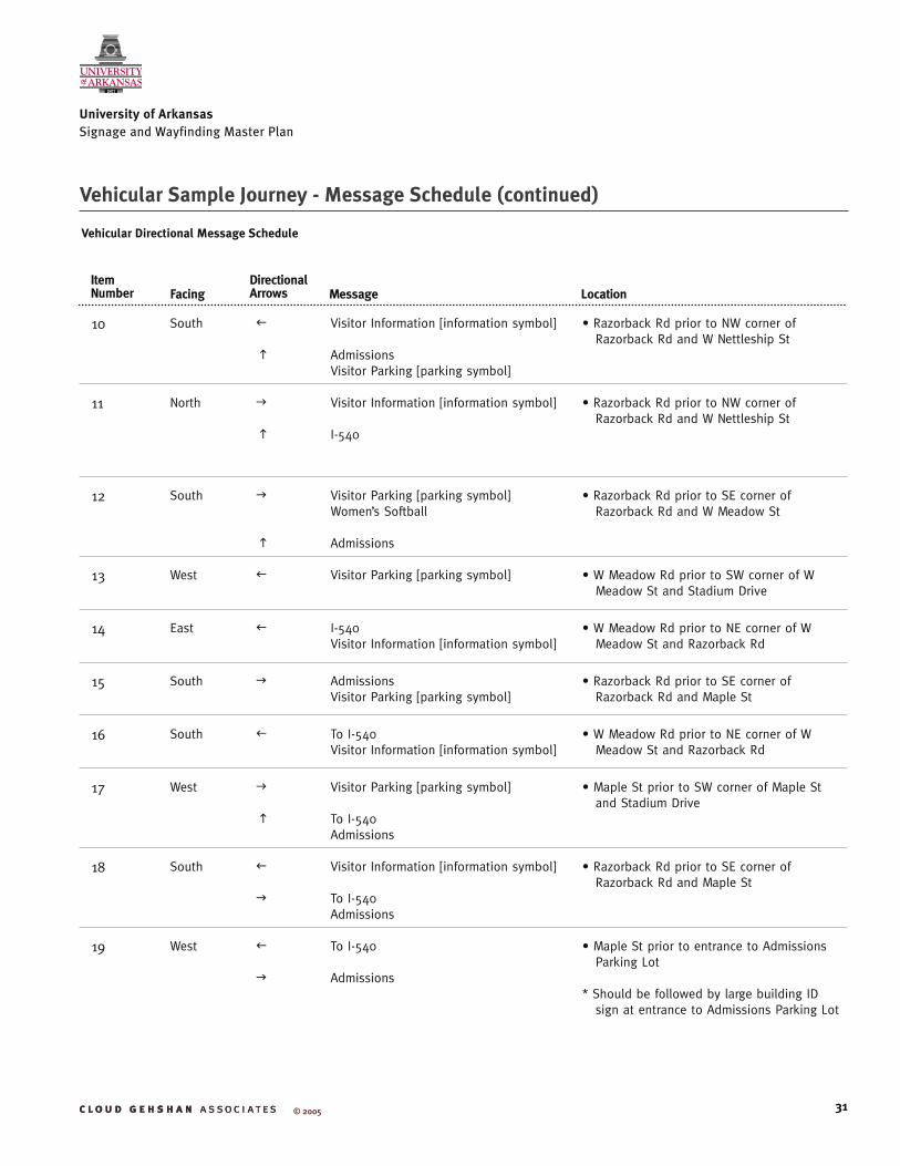
10 South f
h
Visitor Information [information symbol]
AdmissionsVisitor Parking [parking symbol]
• Razorback Rd prior to NW corner of Razorback Rd and W Nettleship St
11 North g
h
Visitor Information [information symbol]
I-540
• Razorback Rd prior to NW corner of Razorback Rd and W Nettleship St
12 South g
h
Visitor Parking [parking symbol]Women’s Softball
Admissions
• Razorback Rd prior to SE corner of Razorback Rd and W Meadow St
13 West f Visitor Parking [parking symbol] • W Meadow Rd prior to SW corner of W Meadow St and Stadium Drive
14 East f I-540Visitor Information [information symbol]
• W Meadow Rd prior to NE corner of W Meadow St and Razorback Rd
15 South g Admissions Visitor Parking [parking symbol]
• Razorback Rd prior to SE corner of Razorback Rd and Maple St
16 South f To I-540Visitor Information [information symbol]
• W Meadow Rd prior to NE corner of W Meadow St and Razorback Rd
17 West g
h
Visitor Parking [parking symbol]
To I-540Admissions
• Maple St prior to SW corner of Maple St and Stadium Drive
18 South f
g
Visitor Information [information symbol]
To I-540Admissions
• Razorback Rd prior to SE corner of Razorback Rd and Maple St
19 West f
g
To I-540
Admissions
• Maple St prior to entrance to Admissions Parking Lot
* Should be followed by large building ID sign at entrance to Admissions Parking Lot
Vehicular Sample Journey - Message Schedule (continued)
Vehicular Directional Message Schedule

32
University of Arkansas Signage and Wayfinding Master Plan
© 2005
ItemNumber Facing
Directional Arrows Message Location
20 East f To I-540 • At exit ramp from IMTF Parking
21 North f Visitor Parking [parking symbol] • On Stadium Drive at entry ramp to IMTF Parking
22 South g Visitor Parking [parking symbol] • On Stadium Drive at entry ramp to IMTF Parking
24 North g To I-540Visitor Information [information symbol]
• On Stadium Drive at NW corner of Stadium Drive and W Meadow St
25 West f
g
AdmissionsVisitor Parking [parking symbol]
To I-540
• W Nettleship St at SW corner of W Netttleship St and Razorback Rd
26 South g Athletics Center • Razorback Rd prior to SE corner of Razorback Rd and entry to Athletics Center Parking Lot
* Might also be a large building ID sign
27 North f
h
Visitor Parking [parking symbol]Women’s Softball
I-540Visitor Information [information symbol]
• Razorback Rd prior to SE corner of Razorback Rd and W Meadow St
Vehicular Sample Journey - Message Schedule (continued)
Vehicular Directional Message Schedule

33
University of Arkansas Signage and Wayfinding Master Plan
© 2005
Signage Location Criteria
Vehicular Trailblazer (Single message)Orientation: At a right angle to path of movement.
Sight Lines: Unobstructed by plant material, utility poles, or other signs and elements when viewed within intended viewing distance. Sight lines judged from the center of travel lanes in the roadway at a point 40 inches above the road surface (driver’s eye height).
Clearance: Minimum of 2 foot clearance between the near edge of a sign and the curb face and a minimum of 7.5 foot clearance above the ground. 2 foot clearance may be reduced to one foot where sidewalk is limited or existing poles are close to the curb. In more rural areas a 6 foot clearance from the curb is required.
Location of initial sign to parking lot: Within 2 blocks or 500 feet of parking lot or turn off major arterial to reach the lot.
Location on additional sign on block with decision point intersection: Preferably 200 feet from intersection or entry when left turn is required or 100 feet from intersection when no left turn is required. Shorter distances may be required to avoid intervening streets or corners between sign & point of decision.
Location of signs to one another: No vehicular trailblazers or directional signs on different poles within 100 feet of each other on the same side of the road. Where intersections intervene within 100 feet this may be ignored.
Vehicular Directional Orientation: At a right angle to path of movement.
Sight Lines: Unobstructed by plant material, utility poles, or other signs and elements when viewed within intended viewing distance. Sight lines judged from the center of travel lanes in the roadway at a point 40 inches above the road surface (driver’s eye height).
Clearance: Minimum of 2 foot clearance between the near edge of a sign and the curb face and a minimum of 7.5 foot clearance above the ground. 2 foot clearance may be reduced to one foot where sidewalk is limited
or existing poles are close to the curb. In more rural areas a 6 foot clearance from the curb is required.
Location of initial sign to destination: Within 750 feet of destination or turn off major arterial to reach destination (approximately 3 blocks) or (20 seconds at 25 mph) or (15 seconds at 35 mph).
Location on additional sign on block with decision point intersection: Preferably 200 feet from intersection or entry when left turn is required or 100 feet from intersection when no left turn is required. Shorter distances may be required to avoid intervening streets or corners between sign & point of decision.
Location of signs to one another: No vehicular trailblazers or directional signs on different poles within 100 feet of each other on the same side of the road. Where intersections intervene within 100 feet this may be ignored.
Parking Lot IdentificationOrientation: At a right angle to traffic flow (motor vehicle or pedestrian).
Sight Lines: Unobstructed by plant material, utility poles, or other signs and elements when viewed within intended viewing distance. Sight lines judged from the center of travel lanes in the roadway at a point 40 inches above the road surface (driver’s eye height).
Clearances: Minimum of 2 foot clearance between the near edge of a sign and the curb face and a minimum of 7.5 foot clearance above the ground. 2 foot clearance may be reduced to one foot where sidewalk is limited or existing poles are close to the curb. Location at entry to parking lot: A sign at each entry to the parking lot which may be combined with the requirement for street placement above. Buildings with dedicated parking lots adjacent should have an additional building identification sign at the street entrance to the parking lot.
34
University of Arkansas Signage and Wayfinding Master Plan
© 2005
Parking Information Sight Lines: Unobstructed by plant material, utility poles, or other signs and elements when viewed within intended viewing distance. Sight lines judged from the center of travel lanes in the roadway at a point 40 inches above the road surface (driver’s eye height).
Clearances: Minimum of 2 foot clearance between the near edge of a sign and the curb face and a minimum of 7.5 foot clearance above the ground. 2 foot clearance may be reduced to one foot where sidewalk is limited or existing poles are close to the curb. Only applicable where sign is adjacent to roadway. In other areas signs should not be exposed to being hit by motor vehicles nor should they obstruct the pedestrian right-of-way. Location within parking lot: Signs for each row of parking & for each 100 feet of row. Additionally, a sign should be placed facing each entry.
Mounting: May be freestanding or mounted on building as appropriate.
Informational StationOrientation: Kiosks should be oriented so that maps show what is ahead of the viewer on the map as up. This is more important than a right angle orientation to the flow of traffic (vehicle or pedestrian).
Sight Lines: Unobstructed by plant material, utility poles, or other signs and elements when viewed within intended viewing distance. Sight lines judged from the center of travel path. If for motorists, then from center of lane in the roadway at a point 40 inches above the road surface (driver’s eye height). If intended for drivers it should be visible and recognizable from at least 200 feet. If for pedestrian traffic it should be visible and recognizable from at least 100 feet away.
Clearances: The kiosk should be approachable by all pedestrian users, whether in a wheelchair or not. Height should provide clearance for a wheelchair user to get close to the map and other information components. This may require a separate concrete pad connected to the adjacent pedestrian path.
Locations: At pull-offs on major motor vehicle entry routes to campus, at exits to parking structures and lots, at pedestrian entrances to the campus, at main entrances to major buildings on the campus and at major pedestrian intersections within the campus.
Pedestrian Directional Orientation: At a right angle to path of movement.
Sight Lines: Unobstructed by plant material, utility poles, or other signs and elements when viewed within intended viewing distance. Sight lines judged from the pedestrian path at twice maximum reading distance. At intersections obstructions should not obscure visibility of the sign from other corners.
Clearance: Minimum of 1 foot clearance between the near edge of a sign and the pedestrian path. A sightly impaired person should be able to get up next to the sign to read it without stepping off the sidewalk.
Location of initial sign denoting a pedestrian destination: On signs within 500 feet of destination and at pedestrian exits to public parking lots serving the facility.
Frequency: Within the institutional core of campus there should be one on each block at intersections. Outside the institutional core one at decision points may be appropriate. Directional signs may be altered with campus maps/directories.
Bicycle Directional & Trailblazer Orientation: At a right angle to path of movement.
Sight Lines: Unobstructed by plant material, utility poles, or other signs and elements when viewed within intended viewing distance. Sight lines judged from the bicycle path at twice maximum reading distance. At intersections obstructions should not obscure visibility of the sign from other corners.
Clearance: Minimum of 2 foot clearance between the near edge of a sign and the path and a minimum of 7.5 foot clearance above the ground. 2 foot clearance
Signage Location Criteria (continued)

35
University of Arkansas Signage and Wayfinding Master Plan
© 2005
may be reduced to one foot where sidewalk is limited or existing poles are close to the curb.
Location of initial sign to destination: Within 100 feet of destination or turn off major arterial to reach destination. If a left hand turn across motor vehicle traffic is required then the should be 200 feet prior to the decision point or an additional sign should be placed in the block prior to the decision point.
Building Identification Orientation: At a right angle to traffic flow (motor vehicle or pedestrian). Unless there is no setback from the sidewalk in which case it may be building mounted parallel to traffic.
Sight Lines: Unobstructed by plant material, utility poles, or other signs and elements when viewed within intended viewing distance. Sight lines judged from the center of travel lanes in the roadway at a point 40 inches above the road surface (driver’s eye height).
Clearances: Minimum of 2 foot clearance between the near edge of a sign and the curb face and a minimum of 7.5 foot clearance above the ground. 2 foot clearance may be reduced to one foot where sidewalk is limited or existing poles are close to the curb. Only applicable where sign is immediately adjacent to roadway and/or there is a parking lane adjacent. For pedestrian areas the sign needs to be approachable by those with visual limitations or those in wheelchairs. Relationship to Street: For buildings that are set back from the street by a considerable distance or those having a parking lot between building and street a sign should be placed at the edge of the property adjacent to the street(s) fronting the building.
Location at entry to parking lot: A sign at each entry to the parking lot which may be combined with the requirement for street placement above. Buildings with dedicated parking lots adjacent should have an additional building identification sign at the street entrance to the parking lot.
Mounting: May be freestanding or mounted on building as appropriate; when possible, preference should be given to the latter.
Accessible Building EntranceOrientation: At a right angle to pedestrian traffic flow. May need multiple faces at some locations.
Sight Lines: Unobstructed by plant material, utility poles, or other signs and elements when viewed within intended viewing distance. Sight lines judged from the center of travel path. Should be visible from 50 feet.
Clearances: The sign should be approachable by all pedestrian users, whether in a wheelchair or not. Height should provide clearance for a wheelchair user to get close for detailed inspection. This may require a separate concrete pad connected to the adjacent pedestrian path.
Location: At all building entrances, actual or apparent. Location should minimize route retracing by those with disabilities.
Transit StopOrientation: At a right angle to pedestrian traffic flow. May need multiple faces at some locations.
Sight Lines: Unobstructed by plant material, utility poles, or other signs and elements when viewed within intended viewing distance. Sight lines judged from the center of travel path. If for motorists then from center of lane in the roadway at a point 40 inches above the road surface (driver’s eye height). If intended for drivers it should be visible and recognizable from at least 200 feet. If for pedestrian traffic it should be visible and recognizable from at least 100 feet away.
Clearances: The sign should be approachable by all pedestrian users, whether in a wheelchair or not. Height should provide clearance for a wheelchair user to get close for detailed inspection. This may
Signage Location Criteria (continued)

36
University of Arkansas Signage and Wayfinding Master Plan
© 2005
Signage Location Criteria (continued)
require a separate concrete pad connected to the adjacent pedestrian path.
Location: At all transit stops.
Transit Route MapOrientation: At a right angle to pedestrian traffic flow. May need multiple faces at some locations.
Sight Lines: Unobstructed by plant material, utility poles, or other signs and elements when viewed within intended viewing distance. Sight lines judged from the center of travel path. If for motorists then from center of lane in the roadway at a point 40 inches above the road surface (driver’s eye height). If intended for drivers it should be visible and recognizable from at least 200 feet. If for pedestrian traffic it should be visible and recognizable from at least 100 feet away.
Clearances: The sign should be approachable by all pedestrian users, whether in a wheelchair or not. Height should provide clearance for a wheelchair user to get close for detailed inspection. This may require a separate concrete pad connected to the adjacent pedestrian path.
Location: At all transit stops.
Street SignsOrientation: At a right angle to traffic flow.
Sight Lines: Unobstructed by plant material, utility poles, or other signs and elements when viewed within intended viewing distance. Sight lines judged from the center of travel path. If for motorists then from center of lane in the roadway at a point 40 inches above the road surface (driver’s eye height). If intended for drivers it should be visible and recognizable from at least 200 feet. If for pedestrian traffic it should be visible and recognizable from at least 100 feet away.
Clearances: Minimum of 2 foot clearance between the near edge of a sign and the curb face. Depending upon sizes the Arkansas State Highway and Transportation Department (AHTD) may require additional clearance as
a potential hazard. If mounted on overhead control mast arm clearance as required by AHTD.
Locations: At intersections. Also consider separate street signs for pedestrians and vehicles.

37
University of Arkansas Signage and Wayfinding Master Plan
© 2005
Visitor InformationLocation Plan
NS
W E
M
ap K
ey
Vis
ito
r C
ente
r - S
taff
ed
Vis
ito
r In
form
atio
n