university of wyoming king air and cloud radar. - atmospheric
TRANSCRIPT
Atmospheric Science - U. WyomingGabor Vali CloudSat meeting Fabruary 12-13, 2001
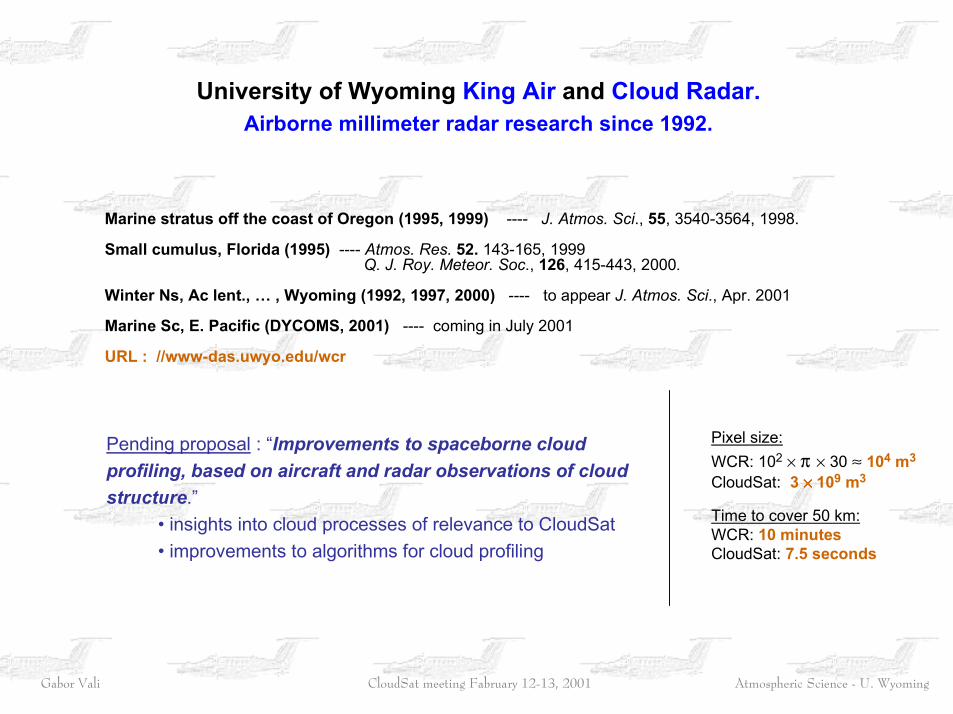
University of Wyoming King Air and Cloud Radar.Airborne millimeter radar research since 1992.
Pixel size:WCR: 102 × π × 30 ≈ 104 m3 CloudSat: 3 ×××× 109 m3
Time to cover 50 km:WCR: 10 minutesCloudSat: 7.5 seconds
Marine stratus off the coast of Oregon (1995, 1999) ---- J. Atmos. Sci., 55, 3540-3564, 1998.
Small cumulus, Florida (1995) ---- Atmos. Res. 52. 143-165, 1999 Q. J. Roy. Meteor. Soc., 126, 415-443, 2000.
Winter Ns, Ac lent., … , Wyoming (1992, 1997, 2000) ---- to appear J. Atmos. Sci., Apr. 2001
Marine Sc, E. Pacific (DYCOMS, 2001) ---- coming in July 2001
URL : //www-das.uwyo.edu/wcr
Pending proposal : “Improvements to spaceborne cloudprofiling, based on aircraft and radar observations of cloudstructure.” • insights into cloud processes of relevance to CloudSat • improvements to algorithms for cloud profiling
Atmospheric Science - U. WyomingGabor Vali CloudSat meeting Fabruary 12-13, 2001
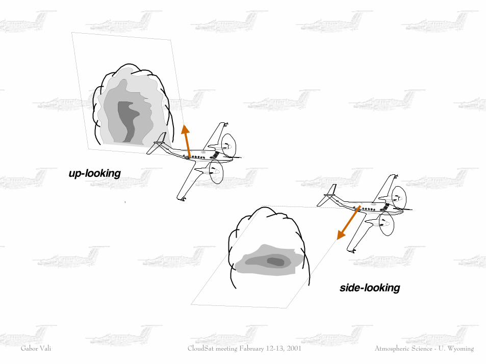
up-looking
side-looking
Atmospheric Science - U. WyomingGabor Vali CloudSat meeting Fabruary 12-13, 2001
0 1 2 3 km
km2.4
2.0
1.6
2.4
2.0
1.6
10 dBZ
0
-10
-20
+6 m s-1
0
-6
Reflectivity
Vertical velocity
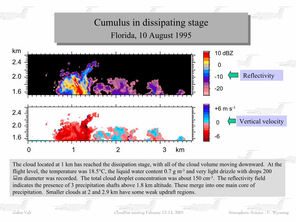
The cloud located at 1 km has reached the dissipation stage, with all of the cloud volume moving downward. At theflight level, the temperature was 18.5°C, the liquid water content 0.7 g m-3 and very light drizzle with drops 200�m diameter was recorded. The total cloud droplet concentration was about 150 cm-3. The reflectivity fieldindicates the presence of 3 precipitation shafts above 1.8 km altitude. These merge into one main core ofprecipitation. Smaller clouds at 2 and 2.9 km have some weak updraft regions.
Cumulus in dissipating stageFlorida, 10 August 1995
Cumulus in dissipating stageFlorida, 10 August 1995
Atmospheric Science - U. WyomingGabor Vali CloudSat meeting Fabruary 12-13, 2001
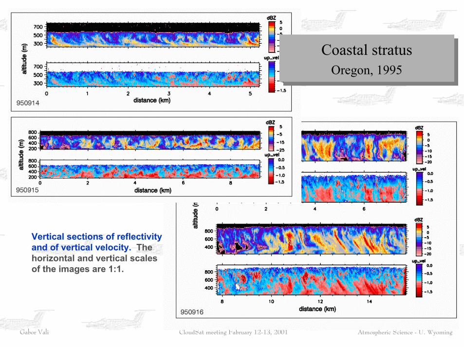
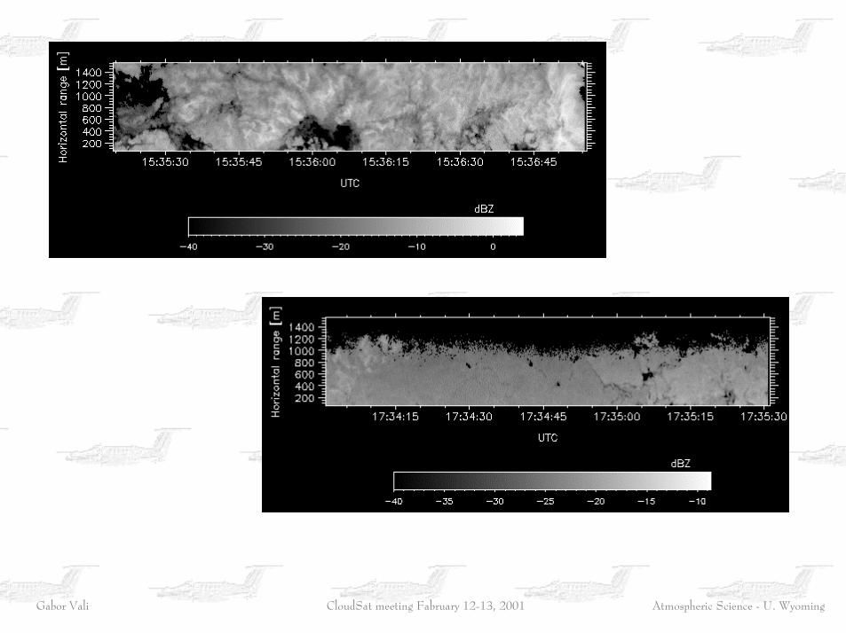
Coastal stratusOregon, 1995
Coastal stratusOregon, 1995
Vertical sections of reflectivityand of vertical velocity. Thehorizontal and vertical scalesof the images are 1:1.

Atmospheric Science - U. WyomingGabor Vali CloudSat meeting Fabruary 12-13, 2001
Horizontal sections of various coastal stratus cases. Attenuation correction has been applied,but signal to noise ratio limits the range of detection. These images demonstrate large varietyin the scales and textures of reflectivity fields.

Atmospheric Science - U. WyomingGabor Vali CloudSat meeting Fabruary 12-13, 2001
990809
990811
990811
Atmospheric Science - U. WyomingGabor Vali CloudSat meeting Fabruary 12-13, 2001
Atmospheric Science - U. WyomingGabor Vali CloudSat meeting Fabruary 12-13, 2001
Atmospheric Science - U. WyomingGabor Vali CloudSat meeting Fabruary 12-13, 2001

Atmospheric Science - U. WyomingGabor Vali CloudSat meeting Fabruary 12-13, 2001
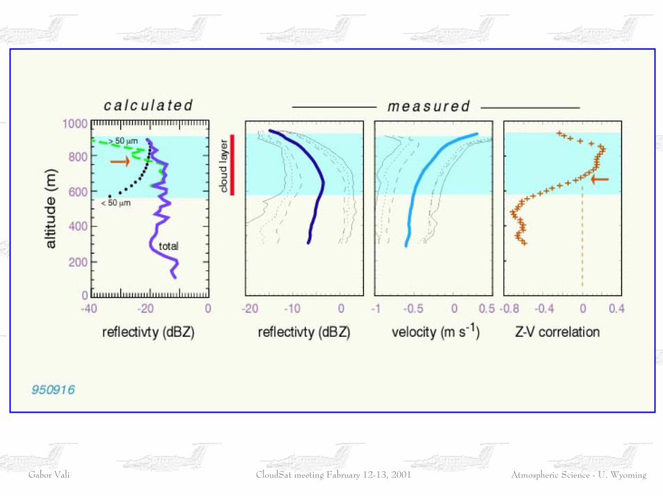
The correlation between Zcalc(derived from in situ dataalong the flight path) and Zobs(radar measurement 90 m tothe side of the aircraft), isvery similar to that betweenradar ranges separated by asimilar distance.
Interpretation of reflectivitypatterns in terms ofspectral characteristics ispossible.
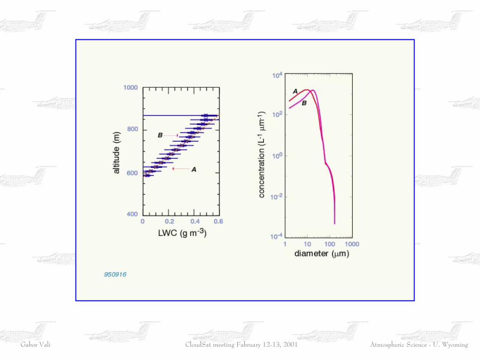
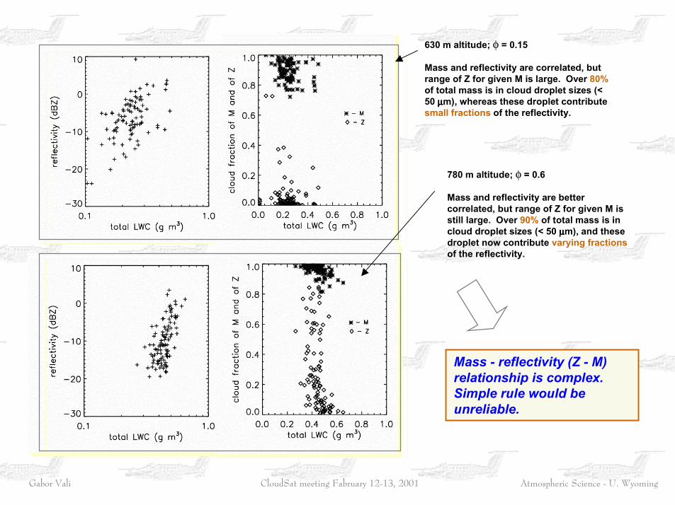
630 m altitude; φ = 0.15
780 m altitude; φ = 0.6
Atmospheric Science - U. WyomingGabor Vali CloudSat meeting Fabruary 12-13, 2001
Atmospheric Science - U. WyomingGabor Vali CloudSat meeting Fabruary 12-13, 2001
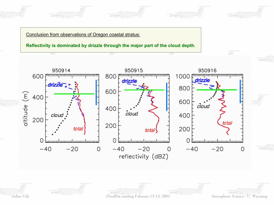
Conclusion from observations of Oregon coastal stratus: Reflectivity is dominated by drizzle through the major part of the cloud depth.
Atmospheric Science - U. WyomingGabor Vali CloudSat meeting Fabruary 12-13, 2001
630 m altitude; φ = 0.15
Mass and reflectivity are correlated, butrange of Z for given M is large. Over 80%of total mass is in cloud droplet sizes (<50 µµµµm), whereas these droplet contributesmall fractions of the reflectivity.
780 m altitude; φ = 0.6
Mass and reflectivity are bettercorrelated, but range of Z for given M isstill large. Over 90% of total mass is incloud droplet sizes (< 50 µµµµm), and thesedroplet now contribute varying fractionsof the reflectivity.
Mass - reflectivity (Z - M)relationship is complex.Simple rule would beunreliable.
Atmospheric Science - U. WyomingGabor Vali CloudSat meeting Fabruary 12-13, 2001
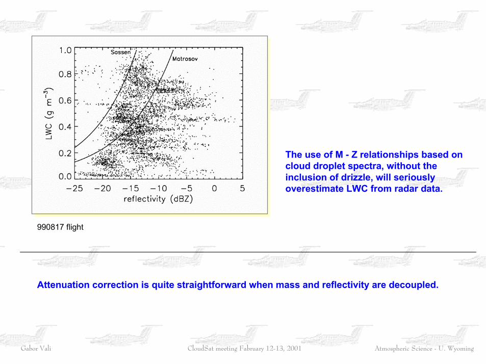
990817 flight
The use of M - Z relationships based oncloud droplet spectra, without theinclusion of drizzle, will seriously overestimate LWC from radar data.
Attenuation correction is quite straightforward when mass and reflectivity are decoupled.
Atmospheric Science - U. WyomingGabor Vali CloudSat meeting Fabruary 12-13, 2001
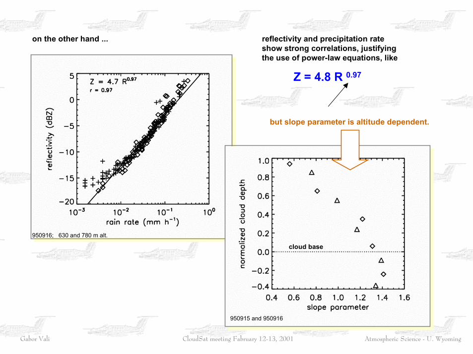
on the other hand ... reflectivity and precipitation rateshow strong correlations, justifyingthe use of power-law equations, like
Z = 4.8 R 0.97
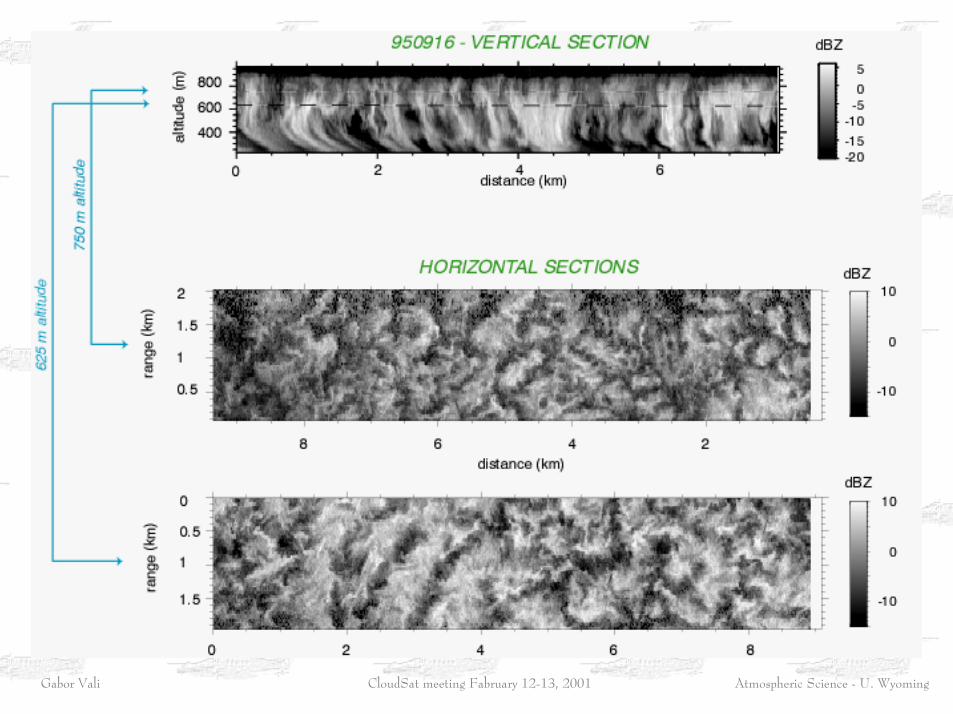
950916; 630 and 780 m alt.
but slope parameter is altitude dependent.
cloud base
950915 and 950916
Atmospheric Science - U. WyomingGabor Vali CloudSat meeting Fabruary 12-13, 2001
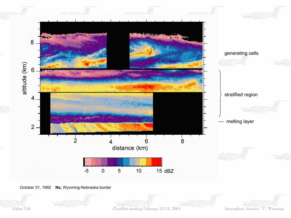
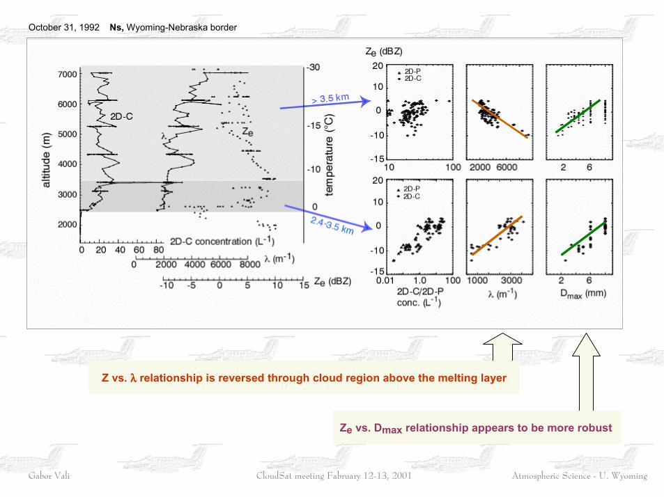
October 31, 1992 Ns, Wyoming-Nebraska border
generating cells
melting layer
stratified region
Atmospheric Science - U. WyomingGabor Vali CloudSat meeting Fabruary 12-13, 2001
Z vs. λλλλ relationship is reversed through cloud region above the melting layer
Ze vs. Dmax relationship appears to be more robust
October 31, 1992 Ns, Wyoming-Nebraska border
Atmospheric Science - U. WyomingGabor Vali CloudSat meeting Fabruary 12-13, 2001
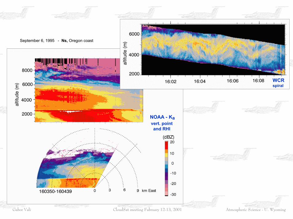
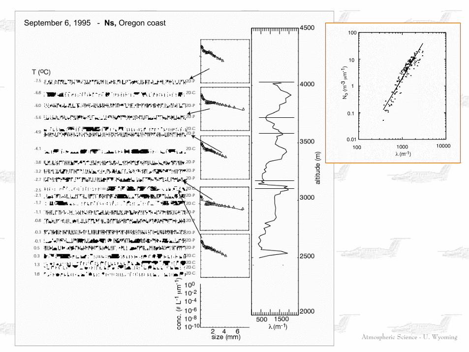
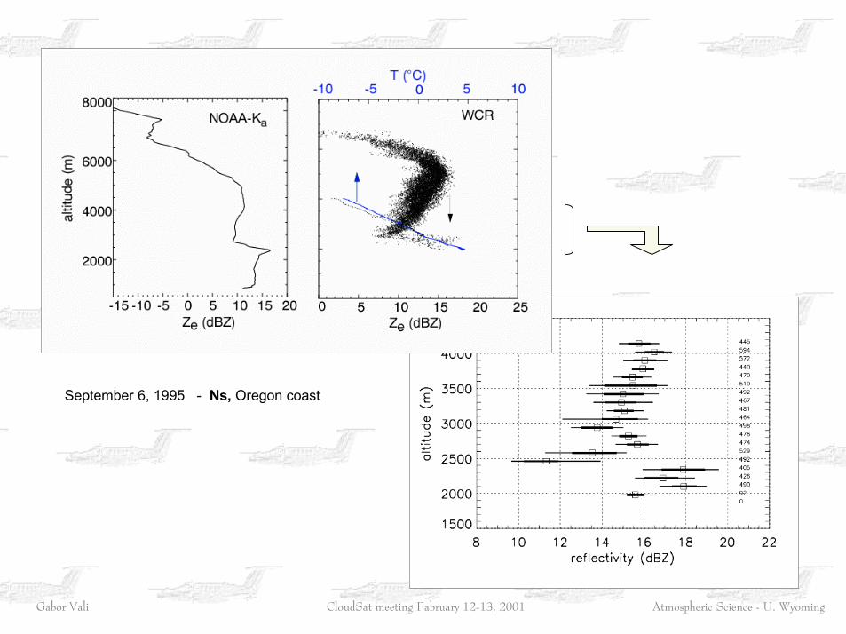
September 6, 1995 - Ns, Oregon coast
NOAA - Kavert. point and RHI
WCRspiral
Atmospheric Science - U. WyomingGabor Vali CloudSat meeting Fabruary 12-13, 2001
September 6, 1995 - Ns, Oregon coast
Atmospheric Science - U. WyomingGabor Vali CloudSat meeting Fabruary 12-13, 2001
September 6, 1995 - Ns, Oregon coast
Atmospheric Science - U. WyomingGabor Vali CloudSat meeting Fabruary 12-13, 2001
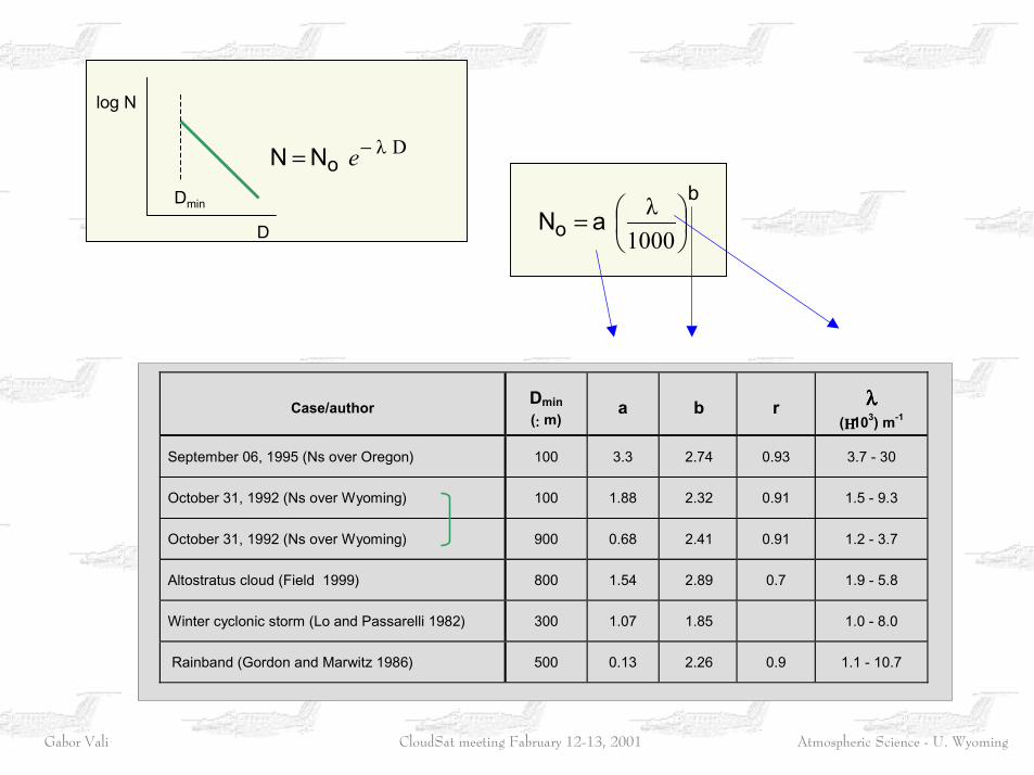
Case/author Dmin(:::: m)
a b r λλλλ(ΗΗΗΗ103) m-1
September 06, 1995 (Ns over Oregon) 100 3.3 2.74 0.93 3.7 - 30
October 31, 1992 (Ns over Wyoming) 100 1.88 2.32 0.91 1.5 - 9.3
October 31, 1992 (Ns over Wyoming) 900 0.68 2.41 0.91 1.2 - 3.7
Altostratus cloud (Field 1999) 800 1.54 2.89 0.7 1.9 - 5.8
Winter cyclonic storm (Lo and Passarelli 1982) 300 1.07 1.85 1.0 - 8.0
Rainband (Gordon and Marwitz 1986) 500 0.13 2.26 0.9 1.1 - 10.7
b
o aN ��
���
�=1000λ
Dλ−= eoN N
D
log N
Dmin
Atmospheric Science - U. WyomingGabor Vali CloudSat meeting Fabruary 12-13, 2001

Atmospheric Science - U. WyomingGabor Vali CloudSat meeting Fabruary 12-13, 2001
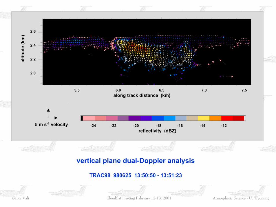
vertical plane dual_Doppler
Atmospheric Science - U. WyomingGabor Vali CloudSat meeting Fabruary 12-13, 2001
5.5 6.0 6.5 7.0 7.5 along track distance (km)
2.6
2.4
2.2
2.0
altit
ude
(km
)
-24 -22 -20 -18 -16 -14 -12 reflectivity (dBZ)
5 m s-1 velocity
vertical plane dual-Doppler analysis
TRAC98 980625 13:50:50 - 13:51:23