update on the water cycle community of practice on the water cycle community of practice rick...
TRANSCRIPT
Update on the Water CycleCommunity of Practice
Rick LawfordNovember 2009
UIC MeetingWashington DC
Community of Practice involves a number of individuals with an enthusiasmfor a specific topic.
In the case of water there are many communities of interest by region, by discipline,by function,. etc.
To address this complexity, the Water Cycle is working towards a structure that allows for all of these interests to be involved provided they connect with GEO interestsat some point.
The activities presently include most of the WA tasks as well as elements in theADC, UIC and CBC activities with opportunities in other areas.
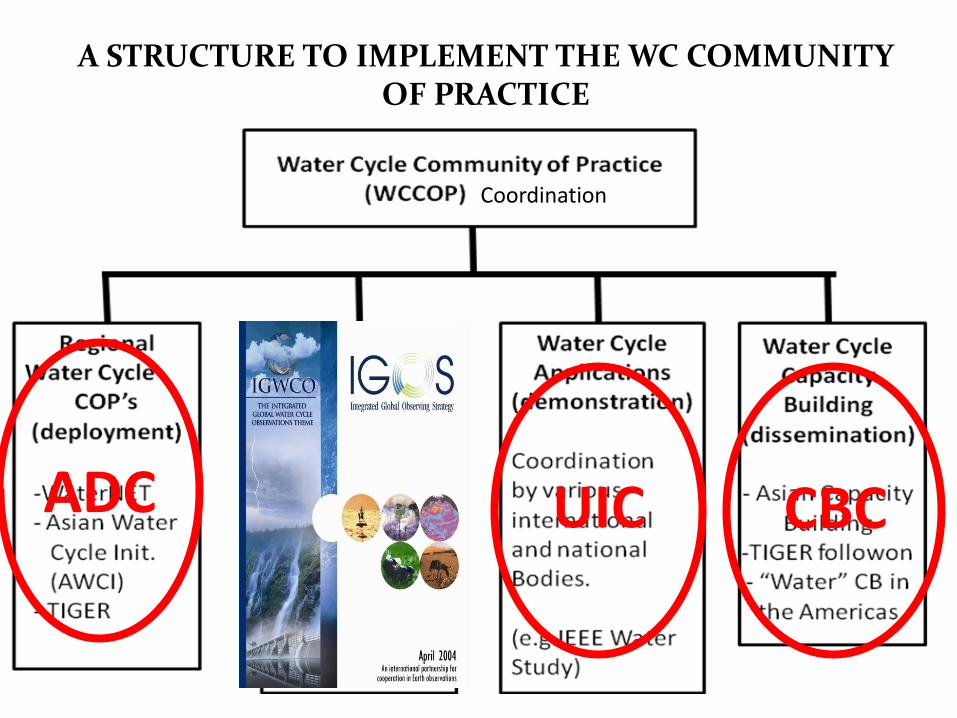
A STRUCTURE TO IMPLEMENT THE WC COMMUNITYOF PRACTICE
Coordination
ADC STC UIC CBC
The Development Stream
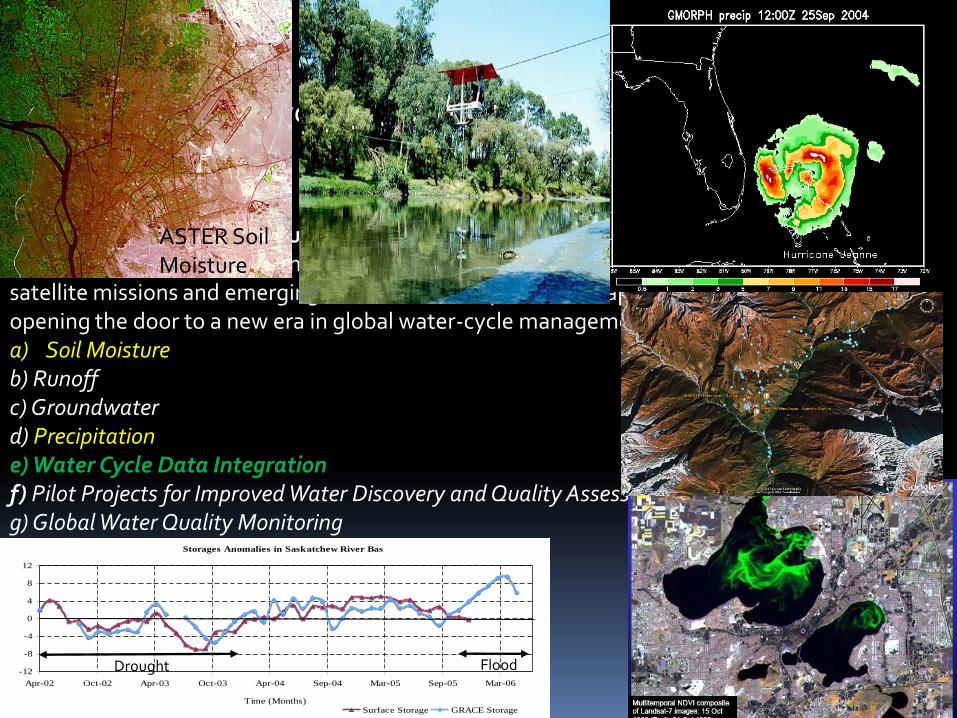
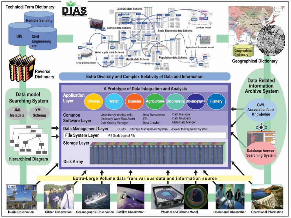
WA-08-01: Integrated Products for Water Resource Management and ResearchImprovements and expansion of in-situ networks, combined with new and existingsatellite missions and emerging assimilation and prediction capabilities, areopening the door to a new era in global water-cycle management.a) Soil Moistureb) Runoffc) Groundwaterd) Precipitatione) Water Cycle Data Integrationf) Pilot Projects for Improved Water Discovery and Quality Assessmentsg) Global Water Quality Monitoring
Primary Water Cycle Sub-Tasks under WA-08-01.
Storages Anomalies in Saskatchew River Basin
-12
-8
-4
0
4
8
12
Apr-02 Oct-02 Apr-03 Oct-03 Apr-04 Sep-04 Mar-05 Sep-05 Mar-06
Time (Months)
Am
ount
(cm
)
Surface Storage GRACE Storage
Drought Flood
ASTER SoilMoisture
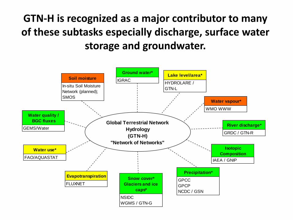
Global Terrestrial Network
Hydrology
(GTN-H)
"Network of Networks"
Snow cover*
Glaciers and ice
caps*
NSIDC
WGMS / GTN-G
Precipitation*
GPCC
GPCP
NCDC / GSN
River discharge*
GRDC / GTN-R
Water vapour*
WMO WWW
Ground water*
IGRAC
GEMS/Water
In-situ Soil Moisture
Network (planned);
SMOS
Soil moisture
Water quality /
BGC fluxes
FAO/AQUASTAT
Water use*
FLUXNET
Evapotranspiration
HYDROLARE /
GTN-L
SHI St. Petersburg?
Lake level/area*
IAEA / GNIP
Isotopic
Composition
GTN-H is recognized as a major contributor to manyof these subtasks especially discharge, surface water
storage and groundwater.
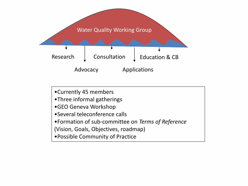
Water Quality Working Group
Research Consultation Education & CB
Advocacy Applications
•Currently 45 members•Three informal gatherings•GEO Geneva Workshop •Several teleconference calls•Formation of sub-committee on Terms of Reference(Vision, Goals, Objectives, roadmap)•Possible Community of Practice
The Deployment Stream
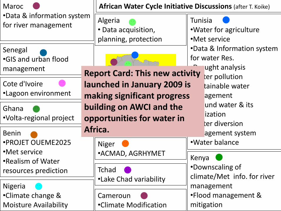
Tunisia•Water for agriculture•Met service•Data & Information system for water Res.•Drought analysis•Water pollution •Sustainable water management•Ground water & its salinization•Water diversionmanagement system•Water balance
Algeria• Data acquisition, planning, protection
Cote d'Ivoire•Lagoon environment
Niger•ACMAD, AGRHYMET
Tchad•Lake Chad variability
Senegal•GIS and urban flood management
Kenya•Downscaling of climate/Met info. for river management•Flood management & mitigation
Maroc•Data & information system for river management
Cameroun•Climate Modification
Benin•PROJET OUEME2025•Met service•Realism of Water resources prediction
African Water Cycle Initiative Discussions (after T. Koike)
Nigeria•Climate change & Moisture Availability
Ghana•Volta-regional project
Report Card: This new activitylaunched in January 2009 is making significant progressbuilding on AWCI and the opportunities for water inAfrica.
ProjAcad Gove Gove Comm Oper Leve Data Full Appr
Project
Participan
ts
Academic Gvt
Research
Gvt
Operations
Commercial Operators Website
Use
Data Base
Downloads
Fully
Open Access
App before
access
NSIDC/ WDC
Boulder
X X X X X 3.2M/y 7.2 million
files/yr*
X
WDC Lanzhou X X X X
WDC Hamburg X X
GRDC
Germany
X X X X 120/y X
GOSIC
NOAA/NCDC/US
X X X X X 2500/d X
GIOVANI NASA/US X X X X 2000/m X
GES-DIS
NASA/US
X X X X 150K/m X
DIAS
Japan
X X X
GENESI-DR
ESA/EC
X X X X X Restricted by
policies
X
Types of Data Users
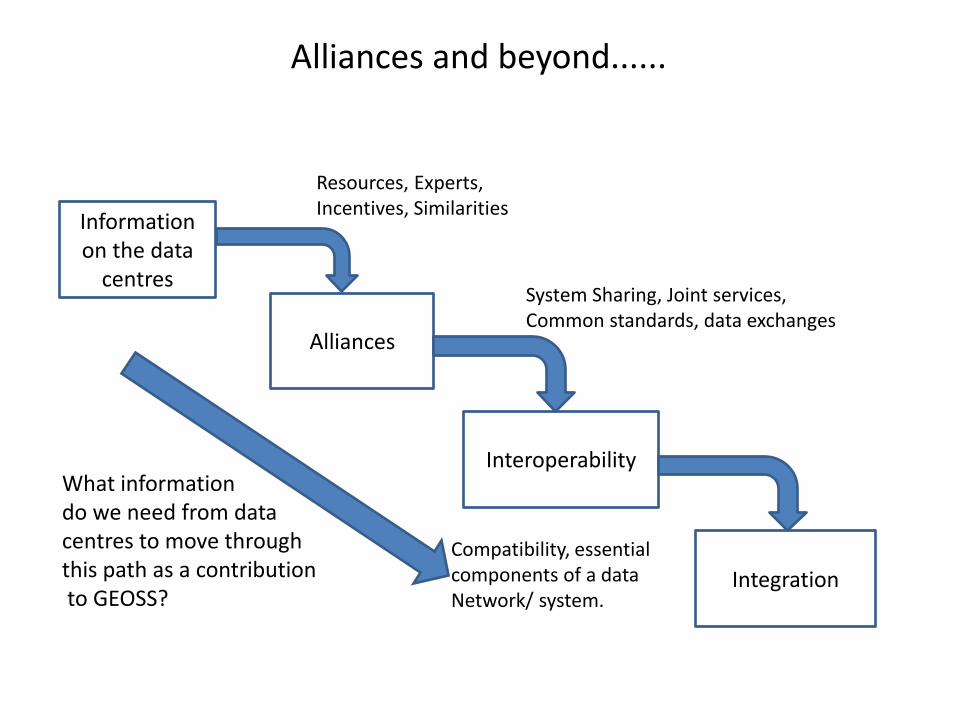
Alliances and beyond......
Information on the data
centres
Alliances
Interoperability
Integration
Resources, Experts, Incentives, Similarities
System Sharing, Joint services,Common standards, data exchanges
Compatibility, essentialcomponents of a data Network/ system.
What informationdo we need from datacentres to move throughthis path as a contributionto GEOSS?
The Demonstration Stream
RGL
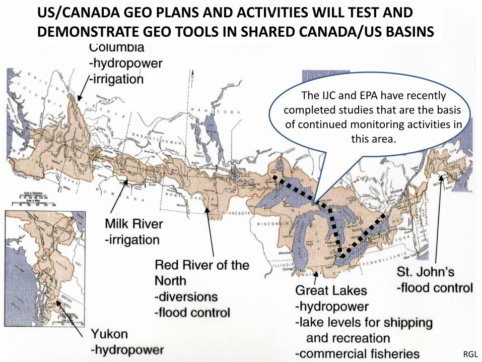
The IJC and EPA have recentlycompleted studies that are the basis of continued monitoring activities in
this area.
US/CANADA GEO PLANS AND ACTIVITIES WILL TEST ANDDEMONSTRATE GEO TOOLS IN SHARED CANADA/US BASINS
Nat ObsPgm
Nat ObsPgm
Nat ObsPgm
Space Agency
Space Agency
NWPCenters
Global/ Regional Archives
ResearchProjects
Data Sys Portal 1
Data Sys Portal 2
Data Sys Portal 3
Data Sys Portal 4
USER 1
USER 2
USER 3
USER 4
USER 5
USER 6
Spec ObsPgm
User Feedback
The value chain for information flows
GOAL: Evaluate and demonstrate the benefits of each step of the value chain for drought
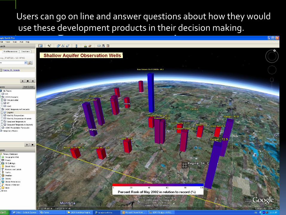
Google Earth ExampleUsers can go on line and answer questions about how they woulduse these development products in their decision making.
The Dissemination Stream
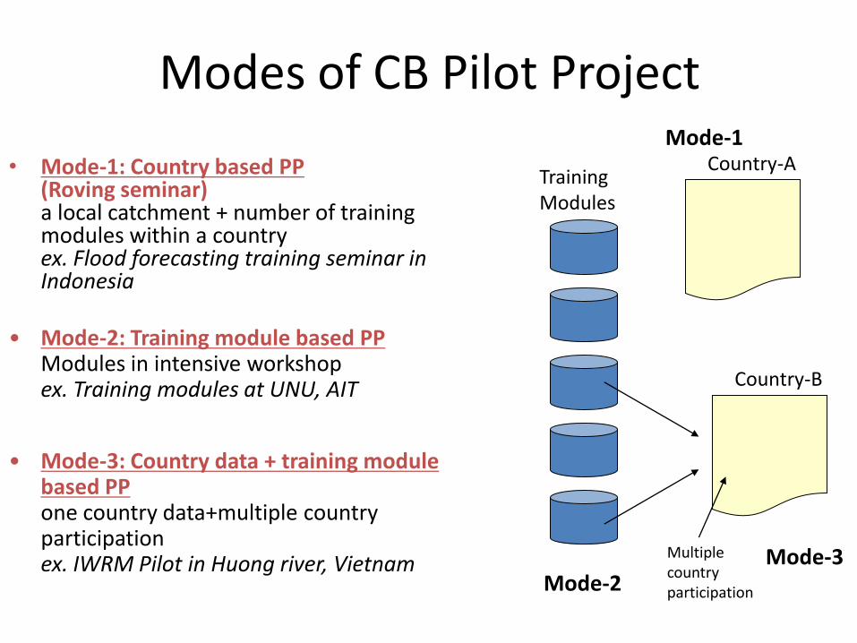
Modes of CB Pilot Project
• Mode-1: Country based PP(Roving seminar)a local catchment + number of training modules within a countryex. Flood forecasting training seminar in Indonesia
Country-AMode-1
Training Modules
Mode-2
Country-B
Mode-3Multiplecountryparticipation
• Mode-2: Training module based PPModules in intensive workshopex. Training modules at UNU, AIT
• Mode-3: Country data + training module based PPone country data+multiple country participationex. IWRM Pilot in Huong river, Vietnam
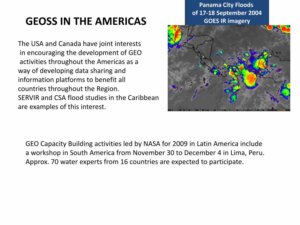
GEOSS IN THE AMERICAS
The USA and Canada have joint interestsin encouraging the development of GEOactivities throughout the Americas as away of developing data sharing andinformation platforms to benefit allcountries throughout the Region.SERVIR and CSA flood studies in the Caribbeanare examples of this interest.
Panama City Floods of 17-18 September 2004
GOES IR imagery
GEO Capacity Building activities led by NASA for 2009 in Latin America include a workshop in South America from November 30 to December 4 in Lima, Peru. Approx. 70 water experts from 16 countries are expected to participate.
Other Activities:
1. Support for the UIC User Needs Survey2. Support for the Water Projects under the CFP Call3. Survey of Water Cycle Data Centres4. Support for Technology Development (SMAP)5. Support to AIP activities6. Overviews of Water Information Requirements in Africa and
Latin America
How this Community of Practice plans to functionIn the future
Full participants would work on either research or applied projects or carry out someaspect of capacity building (on a best efforts basis).
IGWCO and other components would have annual meetings.
Periodic teleconference calls between the Coordinator and the leads of individualCoP components would be held to coordinate the overall effort.
The project leads for all activities would come together every one or two years.Special component sessions would be launched at appropriate meetings (WWF, IAHS, AWRA, AGU, etc.)
An unofficial web site (http: //www.watercycleforum.com)is being set up and all interested people will have an opportunity to become public members of the Water Cycle Community of Practice.
Plans for the coming year:November 2009: An ESA/IGWCO meeting is being held to explore ways to betterintegrate the activities of the elements of Task WA-08-01.November 2009: A Capacity Building Workshop is planned from Lima Peru. It isexpected that 70 to 80 people from more than 18 countries in the Americas willparticipate in the workshop. (WA-06-07a)December 2009: A town hall meeting is planned for the Fall AGU meeting in SanFrancisco. December 2009: A joint IEEE/WC COP workshop is planned with usersin San Francisco (WC COP). The workshop will explore the types of data productsand services that users would to receive from GEO.February 2010: An IGWCO planning meeting is planned for CUNY in New York.A workshop that will involve (IGWCO) and international water management.May 2010: A drought monitoring workshop is planned for May 2010 in WinnipegManitoba (subject to being funded by the Canadian government).Spring 2010: An Asian Water Cycle meeting is planned to be held possibly in Indonesia in conjunction with the Asian Pacific GEOSS Symposium.August or October 2010: A CEOP meeting will be held as part of a pan-GEWEXmeeting.