updated: march 2011 sociocultural evaluation · in evaluating the social, economic and mobility...
TRANSCRIPT

ETDM Process Implementation Handbook 8-1
8. SOCIOCULTURAL EFFECTS EVALUATION
This chapter provides guidance and example commentary for use by the District One SCE Coordinator or MPO ETDM Coordinator/CLC to conduct SCE evaluations during the 45-day project review period. Components of a SCE evaluation that are addressed in this chapter include: 1) evaluating/providing commentary on potential direct project effects to sociocultural resources, 2) recommending ways to avoid/minimize effects, and 3) assigning a DOE to each sociocultural issue. The District One SCE Coordinator or MPO ETDM Coordinator/CLC will collectively be referred to as SCE analyst throughout Chapter 8.
The sociocultural considerations that are evaluated within the ETDM Process include the following issues:
Social Economics Land use Mobility Aesthetics Relocations
To provide the SCE analyst with a sense of the type and degree of analyses that may be useful in determining potential project effects, example commentary is provided for each of the six sociocultural issues identified above. The commentary demonstrates ways of reporting collected data, analyzing the data, and providing a basis for the recommended degrees of effect. Differences in the approach to conducting SCE evaluations conducted under the Planning and Programming Screens are also noted.
This chapter additionally describes the role of the District One ETDM Coordinator and support team in the evaluation of a project’s potential effects to sociocultural resources and the considerations used to support and determine Summary DOEs at the conclusion of the 45-day project review period with the preparation of the project Summary Report. As part of this effort, the District One ETDM Coordinator and support team review and synthesize the ETAT member comments provided for each sociocultural issue (including the comments previously submitted by the SCE analyst), prepare District One ETDM Coordinator commentary, and assign a corresponding Summary DOE.
Accordingly, the District One ETDM Coordinator commentary (prepared for each issue) encompasses the synthesized ETAT member comments and justification/supporting arguments for the assigned Summary DOE. This commentary, in turn, supports the basis for the District One ETDM Coordinator’s COA determination. The overall Summary Report identifies the level of potential project effects to certain resources and forms the basis for refining the PD&E Scope of Services and/or for conducting technical studies to clarify project issues. Differences in the approach to evaluating sociocultural resources and preparing Summary Reports under the Planning and Programming Screens are also presented below.
TIP
For more information about Sociocultural Effects Evaluations, refer to the FDOT SCE Handbook.
Updated: March 2011
8-2 Sociocultural Effects Evaluation
8.1 Preparing for a Sociocultural Effects Evaluation
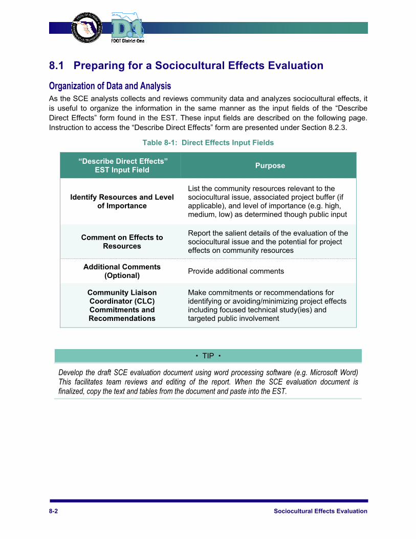
Organization of Data and Analysis As the SCE analysts collects and reviews community data and analyzes sociocultural effects, it is useful to organize the information in the same manner as the input fields of the “Describe Direct Effects” form found in the EST. These input fields are described on the following page. Instruction to access the “Describe Direct Effects” form are presented under Section 8.2.3.
Table 8-1: Direct Effects Input Fields
“Describe Direct Effects” EST Input Field
Purpose
Identify Resources and Level of Importance
List the community resources relevant to the sociocultural issue, associated project buffer (if applicable), and level of importance (e.g. high, medium, low) as determined though public input
Comment on Effects to Resources
Report the salient details of the evaluation of the sociocultural issue and the potential for project effects on community resources
Additional Comments (Optional)
Provide additional comments
Community Liaison Coordinator (CLC) Commitments and Recommendations
Make commitments or recommendations for identifying or avoiding/minimizing project effects including focused technical study(ies) and targeted public involvement
TIP
Develop the draft SCE evaluation document using word processing software (e.g. Microsoft Word) This facilitates team reviews and editing of the report. When the SCE evaluation document is finalized, copy the text and tables from the document and paste into the EST.
ETDM Process Implementation Handbook 8-3
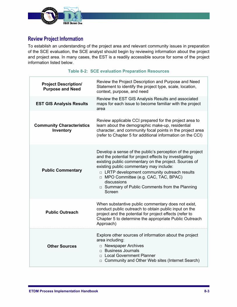
Review Project Information To establish an understanding of the project area and relevant community issues in preparation of the SCE evaluation, the SCE analyst should begin by reviewing information about the project and project area. In many cases, the EST is a readily accessible source for some of the project information listed below.
Table 8-2: SCE evaluation Preparation Resources
Project Description/ Purpose and Need
Review the Project Description and Purpose and Need Statement to identify the project type, scale, location, context, purpose, and need
EST GIS Analysis Results Review the EST GIS Analysis Results and associated maps for each issue to become familiar with the project area
Community Characteristics Inventory
Review applicable CCI prepared for the project area to learn about the demographic make-up, residential character, and community focal points in the project area (refer to Chapter 5 for additional information on the CCI)
Public Commentary
Develop a sense of the public’s perception of the project and the potential for project effects by investigating existing public commentary on the project. Sources of existing public commentary may include: □ LRTP development community outreach results □ MPO Committee (e.g. CAC, TAC, BPAC)
discussions □ Summary of Public Comments from the Planning
Screen
Public Outreach
When substantive public commentary does not exist, conduct public outreach to obtain public input on the project and the potential for project effects (refer to Chapter 5 to determine the appropriate Public Outreach Approach)
Other Sources
Explore other sources of information about the project area including: □ Newspaper Archives □ Business Journals □ Local Government Planner □ Community and Other Web sites (Internet Search)
8-4 Sociocultural Effects Evaluation
Conduct Field Review The SCE analyst should visit the project area to observe physical conditions and use of the corridor (the Pre-Screening Field Review Guide in Chapter 5 may be consulted for a listing of sociocultural features and characteristics that are pertinent to the SCE evaluation). During the filed review, the SCE analyst should record observations in field notes and take photographs for reference. If available, the SCE analyst should use a Global Positioning System (GPS) unit to record significant community focal points to supplement data sets on the EST.
Analyze Existing Conditions The analysis of existing conditions relative to demographics, existing and future land use, community focal points, applicable plans, policies, and designations, and transportation facilities will provide the necessary foundation for evaluating the sociocultural issues.
Demographics The SCE analysts should first compare the demographic characteristics of the project area with those for the county in which the project is located, plus any proximate municipality. In rural areas, the one-mile (5,280 foot) project buffer is a suitable buffer for identifying the affected community. The typically sparse road networks indicate that people have access to fewer routes and, therefore, are more likely to be reliant on the corridor addressed by the project. In contrast, the buffer for the demographic analysis in urban areas can be smaller since the street network usually provides more route choices. Thus, the one quarter-mile (1k,320 foot) project buffer (reflecting a five-minute walking distance) is a suitable buffer for use in urban areas.
To facilitate the comparison of the project buffer area, county, and municipality (if applicable) the demographic characteristics for each should be organized in a tabular format. The population groups (listed below) should be presented as a percentage of the total population. The total population associated with the population group for the project area should also be included.
Population Groups
Caucasian African-American Asian American Indian and Alaska Native Other Hispanic or Latino Under Age 18 Age 65+ Housing Units w/o Car Median Family Income
ETDM Process Implementation Handbook 8-5
In an accompanying narrative, the SCE analyst should describe any notable demographic differences among the geographic units analyzed. The existence of any Title VI protected population groups within the project area and the number of census blocks adjacent to the project with a minority population greater than 40 percent (see EST dataset) should be noted.
While the table and narrative describing the demographic characteristics of the project area are generally documented by the SCE analyst in the EST under the Social issue (see further discussion under Section 8.2), this demographic analysis is especially useful to the SCE analyst in evaluating the Social, Economic and Mobility issues.
Community Focal Points In conjunction with reviewing the demographic characteristics of the project area, the SCE analyst should identify community focal points and/or resources in the project area along with the buffer area in which these features are located. In many instances, community focal points, such as those listed below, are part of the EST datasets. Community features recorded during the field visit, however, should be consulted and used to supplement EST datasets if appropriate.
Community Focal Point Categories
Schools Health care facilities Religious facilities Social service facilities Community centers Cultural facilities Parks Cemeteries Fire stations Historic places Law enforcement facilities Business districts Government buildings Intermodal facilities Major attractors/ multi-use facilities/theme parks Civic centers
TIP
Public input may reveal community focal points that have a high level of importance to the community. If adequate information exists to determine the significance of community focal points, indicate such instances in the corresponding direct effects evaluation. Refer to Chapter 5 for guidance on obtaining public input for the ETDM project reviews.
Existing and Future Land Use Using EST datasets, the SCE analyst should concurrently assess the acreages and percentages of existing and generalized future land use categories in the 100-, 500- and 1,320-foot project buffer areas. In rural areas, the one mile (5,280 foot) buffer may be more suitable than the 1,320-foot buffer since land use patterns tend to be coarser and individual communities typically encompass greater land areas than in urban or suburban areas. Also, in instances where the existing transportation facility typical section is particularly wide (e.g. interstate facility), the evaluation of land uses and potential effects immediately adjacent to the project

8-6 Sociocultural Effects Evaluation
may require a buffer larger than 100 feet. The SCE analysts should select the buffer that is greater than the width of the existing transportation facility to capture adjacent properties.
Significant land uses such as Developments of Regional Impact (DRI), Planned Unit Developments (PUD) or large-scale public lands should additionally be identified.
Land use data is useful to the SCE analysts in evaluating all of the sociocultural issues (see further discussion under Section 8.2).
Plans, Policies, and Designations Research whether any plans, policies, or designations are applicable to the project area or region encompassing the project. Identify neighborhood plans, comprehensive plans, bicycle/pedestrian plans, or other plans that indicate the future desired course of the affected community. Special designations such as Enterprise Zone, Community Redevelopment Area, Front Porch Community, land use/zoning overlay district, and historic district may provide indication of the values and preferences of the affected community relative to the transportation project. The EST and the local government planning staff and relevant Web site are good sources for this type of information.
Transportation Infrastructure and Services Using datasets from the EST, the SCE analysts should inventory the existing transportation facilities and public transportation services in the project area to determine how the project relates to the local and regional transportation systems. The SCE analyst should consult the respective local government comprehensive plan traffic circulation maps to identify existing and future roads, bicycle facilities, pedestrian facilities, transit routes/stops, intermodal facilities, and other transportation facilities in the project area. The Transportation Element policies in the comprehensive plan should also be reviewed for plans or requirements pertaining to the development of sidewalks, bicycle lanes, and transit amenities (e.g. bus shelters).
TIP
Basic information useful for determining project effects for each of the sociocultural issues is the difference between the existing right-of-way width and the estimated right-of-way width for the project. The distance between the parcel boundaries on either side of the linear transportation facility usually represents the existing right-of-way width. The right-of-way width for the project can be roughly estimated by using the example typical sections (Reference 8-1) provided in the Reference Documents Section at the end of this chapter. (Note: Actual project right-of-way needs and locations are determined in the Project Development phase.) The difference between these widths represents the area that could potentially be occupied by the project and, therefore, has the greatest potential to be transformed as a result of the project.
ETDM Process Implementation Handbook 8-7
8.2 Conducting a Sociocultural Effects Evaluation The SCE analyst should consider prior public commentary collected for a project to determine the magnitude of an issue or controversy and the level of specificity for the SCE evaluation. The evaluation of direct effects should consider the potential for both positive and negative project effects on the community, as well as the greater local and regional areas.
Planning Screen When conducting a SCE evaluation for a project undergoing a Planning Screen, the SCE analyst should provide a demographic overview of the people in the affected community and the places that are important to community life; describe potential project effects; and establish a method for communicating with the affected community in order to resolve potential project effects. This allows transportation planners to adjust project concepts to avoid or minimize adverse effects and to improve project cost estimates.
The Planning Screen evaluation should include the following steps:
Review the Project Description and Purpose and Need Statement in the EST to fully understand the project scope
Choose a project buffer(s) appropriate to the analysis. For example, a 500-foot buffer is adequate for identifying the type and extent of commercial activity occurring along the project corridor. In assessing development of employment and industry activities on a countywide and/or regional scale, larger areas beyond a one mile (5,280 foot) buffer are usually necessary
Within the selected project buffers, identify all special designations (e.g. activity centers, Enterprise Zones, Developments of Regional Impact, Community Redevelopment Areas, Front Porch Communities, Historic Districts, etc.)
Review pertinent information not available in the EST such as local government comprehensive plans, newspaper archives, business journals, etc.
Interview the local government’s community planner or economic development agency to better understand the vision of the community and dynamics of the local and regional economies
Provide commentary about the potential project effects on the character, vision, economic conditions, etc. of the affected community, including a description of any “fatal flaws” and recommendations to avoid impacts
Assign a project DOE and provide the basis for the recommendation Recommend targeted public outreach activities to understand the magnitude of potential
project effects and to determine methods for avoiding/minimizing impacts
Programming Screen The Programming Screen occurs before projects are funded in the FDOT Five-Year Work Program. This screening phase initiates the National Environmental Policy Act (NEPA) process for federally funded projects or the State Environmental Impact Process for state-funded projects. Input regarding potential project impacts on a community’s social environment is the basis for “agency scoping” efforts to ensure compliance with NEPA and other applicable federal and state laws. Consequently, the level of analysis during the Programming Screen is more detailed than that required during the Planning Screen. The objective of the SCE analyst in
8-8 Sociocultural Effects Evaluation
conducting a SCE evaluation for a Programming Screen project is to make decisions regarding the nature and status of probable social effects in a project area, determine the need for a technical study to be performed, and assign an overall project DOE.
In addition to the steps included under the Planning Screen, the following tasks should also be conducted:
Review the Planning Summary Report describing the results of the SCE evaluation conducted during the Planning Screen
Review updated sociocultural datasets and GIS analysis results for selected buffers available in the EST
Provide commentary regarding the potential project effects on the sociocultural issue and assign a DOE
Provide scoping recommendations and define, if required, the level of technical study to be performed (e.g. traffic circulation and access study, relocation study, etc.)
Recommend targeted public outreach activities to further understand the magnitude of potential project impacts and to identify methods for avoiding/minimizing impacts.
Guidelines for Assigning Degree of Effect The assigned DOE represents the professional judgment about the potential direct effects a project may have on sociocultural resources in the community, as well as future involvement that may be required to avoid or minimize project impacts. It is based on the findings from the SCE evaluation and public input. The commentary prepared by the SCE analyst should include the basis for the assigned DOE.
The subsections below provide useful data sources, considerations for the evaluation of direct effects, as well as minimum content for the EST input fields for each of the sociocultural issues.
As previously mentioned, the EST includes the following input fields for entering of direct effects:
Identified Resources and Level of Importance Comments on Effects to Resources Additional Comments (Optional) CLC Recommendations and Commitments
The SCE evaluations are entered in the EST by the SCE analyst. This information is used by the District One ETDM Coordinator at the end of the 45-day project review period to develop the Summary Report and determine the Summary DOE for each ETDM issue. Once documented in the EST, the SCE evaluations are available for reference during future project phases.
ETDM Process Implementation Handbook 8-9
Social Effects For the evaluation of potential social effects, the ETAT reviewer should explore the potential for project-related effects on the study area population, including displacement or disproportionate effects on special population groups; traffic patterns through neighborhoods; conditions contributing to social relationships and neighborhood interaction; connectivity and access between neighborhoods and community focal points (including the potential of the project to create isolated areas); community cohesion; emergency service response time; and the vision and/or goals of the community.
The primary buffer should be used for the data sources listed in Table 8-3. If data is not available for that buffer level, the secondary buffer should be used.
Useful Data for Evaluation of Social Effects
Table 8-3: Social Effects Evaluation Data
EST Data Primary Buffer Secondary Buffer
Demographic Data 500-ft 5,280 ft (one mile)
Community Focal Points ~All Buffers*~ ~All Buffers*~
Existing Land Use 500-ft 5,280 ft (one mile)
Future Land Use 500-ft 5,280 ft (one mile)
Parcel Data (Development Pattern)
500-ft 5,280 ft (one mile)
* The EST includes the one mile (5,280-foot), half-mile (2,640-foot), quarter-mile (1,320-foot) , 500-foot, 200-foot and 100-foot buffers.
Additionally, local newspapers, field data, interviews with local government planners and public input may yield valuable information on the social character and dynamics in the project area. Data for demographic comparisons of the project area and county and applicable municipal governments may be viewed on the U.S. Census American Fact Finder Website at www.factfinder.census.gov.
TIP
To document the direct effects of each sociocultural issue in the EST as presented through the SCE evaluation document, navigate to: Tools / Review Project / Direct Effects*. *Ensure that the project is selected in the EST before navigating. Next select the appropriate project alternative, specific sociocultural issue, and DOE using the “Describe Direct Effects” form. Finally, copy and paste the text of the SCE evaluation document under the relevant input fields of the “Describe Direct Effects” form.
8-10 Sociocultural Effects Evaluation
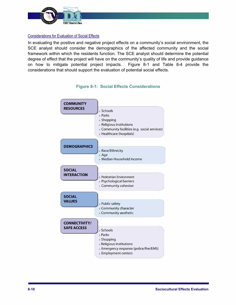
Considerations for Evaluation of Social Effects
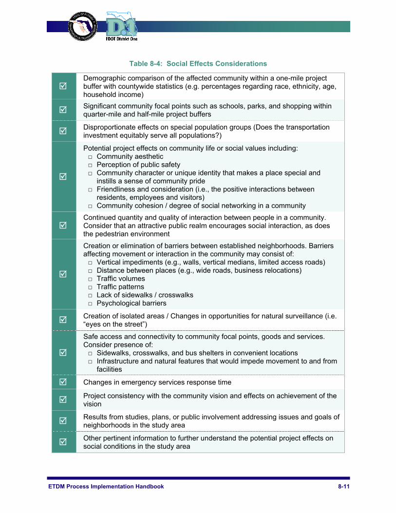
In evaluating the positive and negative project effects on a community’s social environment, the SCE analyst should consider the demographics of the affected community and the social framework within which the residents function. The SCE analyst should determine the potential degree of effect that the project will have on the community’s quality of life and provide guidance on how to mitigate potential project impacts. Figure 8-1 and Table 8-4 provide the considerations that should support the evaluation of potential social effects.
Figure 8-1: Social Effects Considerations
ETDM Process Implementation Handbook 8-11
Table 8-4: Social Effects Considerations
Demographic comparison of the affected community within a one-mile project buffer with countywide statistics (e.g. percentages regarding race, ethnicity, age, household income)
Significant community focal points such as schools, parks, and shopping within quarter-mile and half-mile project buffers
Disproportionate effects on special population groups (Does the transportation investment equitably serve all populations?)
Potential project effects on community life or social values including: □ Community aesthetic □ Perception of public safety □ Community character or unique identity that makes a place special and
instills a sense of community pride □ Friendliness and consideration (i.e., the positive interactions between
residents, employees and visitors) □ Community cohesion / degree of social networking in a community
Continued quantity and quality of interaction between people in a community. Consider that an attractive public realm encourages social interaction, as does the pedestrian environment
Creation or elimination of barriers between established neighborhoods. Barriers affecting movement or interaction in the community may consist of: □ Vertical impediments (e.g., walls, vertical medians, limited access roads) □ Distance between places (e.g., wide roads, business relocations) □ Traffic volumes □ Traffic patterns □ Lack of sidewalks / crosswalks □ Psychological barriers
Creation of isolated areas / Changes in opportunities for natural surveillance (i.e. “eyes on the street”)
Safe access and connectivity to community focal points, goods and services. Consider presence of: □ Sidewalks, crosswalks, and bus shelters in convenient locations □ Infrastructure and natural features that would impede movement to and from
facilities
Changes in emergency services response time
Project consistency with the community vision and effects on achievement of the vision
Results from studies, plans, or public involvement addressing issues and goals of neighborhoods in the study area
Other pertinent information to further understand the potential project effects on social conditions in the study area
8-12 Sociocultural Effects Evaluation
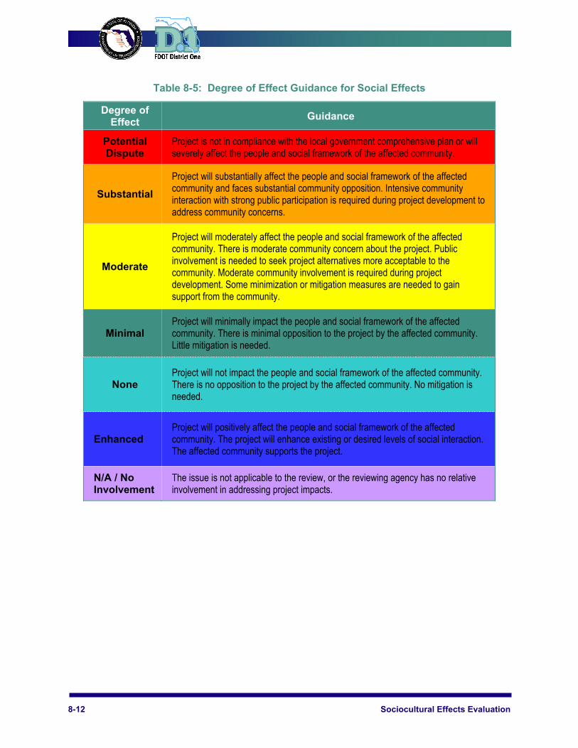
Table 8-5: Degree of Effect Guidance for Social Effects
Degree of Effect
Guidance
Potential Dispute
Project is not in compliance with the local government comprehensive plan or will severely affect the people and social framework of the affected community.
Substantial
Project will substantially affect the people and social framework of the affected community and faces substantial community opposition. Intensive community interaction with strong public participation is required during project development to address community concerns.
Moderate
Project will moderately affect the people and social framework of the affected community. There is moderate community concern about the project. Public involvement is needed to seek project alternatives more acceptable to the community. Moderate community involvement is required during project development. Some minimization or mitigation measures are needed to gain support from the community.
Minimal Project will minimally impact the people and social framework of the affected community. There is minimal opposition to the project by the affected community. Little mitigation is needed.
None Project will not impact the people and social framework of the affected community. There is no opposition to the project by the affected community. No mitigation is needed.
Enhanced Project will positively affect the people and social framework of the affected community. The project will enhance existing or desired levels of social interaction. The affected community supports the project.
N/A / No Involvement
The issue is not applicable to the review, or the reviewing agency has no relative involvement in addressing project impacts.
ETDM Process Implementation Handbook 8-13
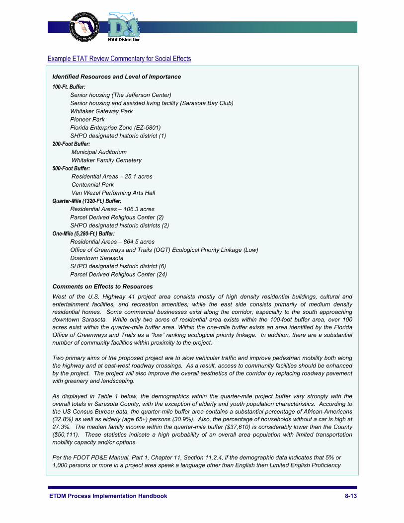
Example ETAT Review Commentary for Social Effects
Identified Resources and Level of Importance 100-Ft. Buffer:
Senior housing (The Jefferson Center) Senior housing and assisted living facility (Sarasota Bay Club) Whitaker Gateway Park Pioneer Park Florida Enterprise Zone (EZ-5801) SHPO designated historic district (1)
200-Foot Buffer: Municipal Auditorium Whitaker Family Cemetery
500-Foot Buffer: Residential Areas – 25.1 acres Centennial Park Van Wezel Performing Arts Hall
Quarter-Mile (1320-Ft.) Buffer: Residential Areas – 106.3 acres Parcel Derived Religious Center (2) SHPO designated historic districts (2)
One-Mile (5,280-Ft.) Buffer: Residential Areas – 864.5 acres Office of Greenways and Trails (OGT) Ecological Priority Linkage (Low) Downtown Sarasota SHPO designated historic district (6) Parcel Derived Religious Center (24)
Comments on Effects to Resources West of the U.S. Highway 41 project area consists mostly of high density residential buildings, cultural and entertainment facilities, and recreation amenities; while the east side consists primarily of medium density residential homes. Some commercial businesses exist along the corridor, especially to the south approaching downtown Sarasota. While only two acres of residential area exists within the 100-foot buffer area, over 100 acres exist within the quarter-mile buffer area. Within the one-mile buffer exists an area identified by the Florida Office of Greenways and Trails as a “low” ranking ecological priority linkage. In addition, there are a substantial number of community facilities within proximity to the project. Two primary aims of the proposed project are to slow vehicular traffic and improve pedestrian mobility both along the highway and at east-west roadway crossings. As a result, access to community facilities should be enhanced by the project. The project will also improve the overall aesthetics of the corridor by replacing roadway pavement with greenery and landscaping. As displayed in Table 1 below, the demographics within the quarter-mile project buffer vary strongly with the overall totals in Sarasota County, with the exception of elderly and youth population characteristics. According to the US Census Bureau data, the quarter-mile buffer area contains a substantial percentage of African-Americans (32.8%) as well as elderly (age 65+) persons (30.9%). Also, the percentage of households without a car is high at 27.3%. The median family income within the quarter-mile buffer ($37,610) is considerably lower than the County ($50,111). These statistics indicate a high probability of an overall area population with limited transportation mobility capacity and/or options. Per the FDOT PD&E Manual, Part 1, Chapter 11, Section 11.2.4, if the demographic data indicates that 5% or 1,000 persons or more in a project area speak a language other than English then Limited English Proficiency
8-14 Sociocultural Effects Evaluation
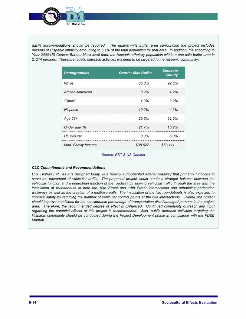
(LEP) accommodations should be required. The quarter-mile buffer area surrounding the project includes persons of Hispanic ethnicity amounting to 6.1% of the total population for that area. In addition, the according to Year 2000 US Census Bureau block-level data, the Hispanic ethnicity population within a one-mile buffer area is 2, 214 persons. Therefore, public outreach activities will need to be targeted to the Hispanic community.
Demographics Quarter-Mile Buffer Sarasota County
White 86.8% 92.6%
African-American 8.9% 4.2%
“Other” 4.3% 3.2%
Hispanic 10.2% 4.3%
Age 65+ 25.6% 31.5%
Under age 18 21.7% 16.2%
HH w/o car 8.3% 6.0%
Med. Family Income $38,627 $50,111
Source: EST & US Census
CLC Commitments and Recommendations
U.S. Highway 41, as it is designed today, is a heavily auto-oriented arterial roadway that primarily functions to serve the movement of vehicular traffic. The proposed project would create a stronger balance between the vehicular function and a pedestrian function of the roadway by slowing vehicular traffic through the area with the installation of roundabouts at both the 10th Street and 14th Street intersections and enhancing pedestrian walkways as well as the creation of a multiuse path. The installation of the two roundabouts is also expected to improve safety by reducing the number of vehicular conflict points at the two intersections. Overall, the project should improve conditions for the considerable percentage of transportation disadvantaged persons in the project area. Therefore, the recommended degree of effect is Enhanced. Continued community outreach and input regarding the potential effects of this project is recommended. Also, public outreach activities targeting the Hispanic community should be conducted during the Project Development phase in compliance with the PD&E Manual.

ETDM Process Implementation Handbook 8-15
Economic Effects To evaluate of economic effects, the SCE analyst should identify major employers in the project area and industries within the region that could be affected by the project. The relevant components contributing to the economic activity within the affected community, as well as those elements impacting the economies of the county and region should be identified. Relevant data sources the evaluation of potential economic effects are listed in Table 8-6.
Table 8-6: Useful Economic Effects Evaluation Data
EST Data Primary Buffer Secondary Buffer
Aerial Map 5,280-ft. (one mile) ~ Regional ~
Demographics Low Income Minority
500-ft. 5,280-ft. (one mile)
Existing Land Use 500-ft. 5,280-ft. (one mile)
Future Land Use 500-ft. 5,280-ft. (one mile)
Local Street Network 500-ft. 5,280-ft. (one mile)
Regional Road Network ~ Regional ~
Parcel Data (Existing Right-of-Way Width)
100-ft. 200-ft.
Proposed Typical Section (Proposed Right-of-Way Width)
N/A N/A
Railroads 500-ft. 5,280-ft. (one mile)
Airports 5,280-ft. (one mile) ~ Regional ~
Transit Stations/Stops 1,320-ft. 2,640-ft.
Special Designations: Florida Main Street Historic District Community Redevelopment Area Front Porch Community Enterprise Zone
500-ft. 5,280-ft. (one mile)
Additionally, regional business journals, local newspapers, plans and studies addressing economic issues and public input may yield valuable information on economic activities, trends, and plans in the project area.

8-16 Sociocultural Effects Evaluation
Considerations for Evaluation of Economic Effects
The SCE analyst should consider economic plans or special designations relevant to the project area in evaluating potential economic effects. The SCE analyst should also consider how accessibility to employment centers will be affected or enhanced by the project. Figure 8–2 and Table 8–7 provide the relevant considerations supporting the analysis of potential economic effects.
Figure 8-2: Economic Effects Considerations
ETDM Process Implementation Handbook 8-17
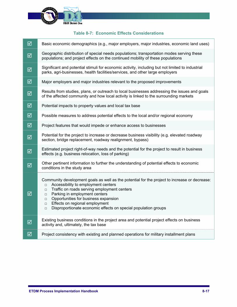
Table 8-7: Economic Effects Considerations
Basic economic demographics (e.g., major employers, major industries, economic land uses)
Geographic distribution of special needs populations; transportation modes serving these populations; and project effects on the continued mobility of these populations
Significant and potential stimuli for economic activity, including but not limited to industrial parks, agri-businesses, health facilities/services, and other large employers
Major employers and major industries relevant to the proposed improvements
Results from studies, plans, or outreach to local businesses addressing the issues and goals of the affected community and how local activity is linked to the surrounding markets
Potential impacts to property values and local tax base
Possible measures to address potential effects to the local and/or regional economy
Project features that would impede or enhance access to businesses
Potential for the project to increase or decrease business visibility (e.g. elevated roadway section, bridge replacement, roadway realignment, bypass)
Estimated project right-of-way needs and the potential for the project to result in business effects (e.g. business relocation, loss of parking)
Other pertinent information to further the understanding of potential effects to economic conditions in the study area
Community development goals as well as the potential for the project to increase or decrease: □ Accessibility to employment centers □ Traffic on roads serving employment centers □ Parking in employment centers □ Opportunities for business expansion □ Effects on regional employment □ Disproportionate economic effects on special population groups
Existing business conditions in the project area and potential project effects on business activity and, ultimately, the tax base
Project consistency with existing and planned operations for military installment plans
8-18 Sociocultural Effects Evaluation
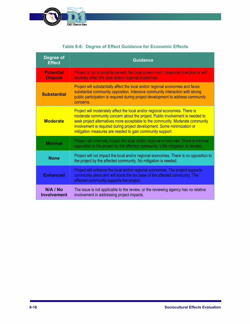
Table 8-8: Degree of Effect Guidance for Economic Effects
Degree of Effect
Guidance
Potential Dispute
Project is not in compliance with the local government comprehensive plan or will severely affect the local and/or regional economies.
Substantial
Project will substantially affect the local and/or regional economies and faces substantial community opposition. Intensive community interaction with strong public participation is required during project development to address community concerns.
Moderate
Project will moderately affect the local and/or regional economies. There is moderate community concern about the project. Public involvement is needed to seek project alternatives more acceptable to the community. Moderate community involvement is required during project development. Some minimization or mitigation measures are needed to gain community support.
Minimal Project will minimally impact the local and/or regional economies. There is minimal opposition to the project by the affected community. Little mitigation is needed.
None Project will not impact the local and/or regional economies. There is no opposition to the project by the affected community. No mitigation is needed.
Enhanced Project will enhance the local and/or regional economies. The project supports community plans and will boost the tax base of the affected community. The affected community supports the project.
N/A / No Involvement
The issue is not applicable to the review, or the reviewing agency has no relative involvement in addressing project impacts.

ETDM Process Implementation Handbook 8-19
Example Commentary by SCE Analyst for Economic Issue
Identified Resources and Level of Importance
500-Foot Buffer: Retail Development Employment
Comments on Effects to Resources
Within the study area, US 41 is a major north-south corridor extending from Charlotte County to the north and Collier County to the south. It is a largely commercial corridor offering financial and medical-related services to businesses throughout the county.
The proposed overpass at US 41 and Bonita Beach Road will likely provide greater levels of mobility and accessibility not only to the commercial services and health and finance support services along US 41, but throughout Lee County and the region. Additionally, Goodwill Industries provides a major source of job training and positions, as does Wal-Mart, and other retail and restaurant services. Tourism is a major industry in Lee County and Bonita Beach Road is one of only two roads providing access to Fort Myers Beach, a popular area to visit.
Additionally, job growth and the labor pool in Lee County are always expanding and the economic climate is favorable. The largest representation of employment in the county is in the Trade, Transportation & Utilities sector and the Education & Health Services sector. With the increasing number of service related businesses locating along US 41, the proposed overpass is likely to improve mobility and accessibility along the corridor. The project may affect driveway access to businesses located near the proposed overpass during construction and potentially impact the short-term viability of these businesses.
Right-of-way impacts should be adequately examined to determine the potential effect on commercial and residential land uses. Property values for commercial uses within the project area are likely to increase as a result of the new overpass. Impacts to residential uses are expected to be minimal. The project should have a net benefit to the Lee County tax base.
CLC Commitments and Recommendations
It is recommended that targeted public outreach be conducted in the community to solicit input from the general public as well as business interests in the study area, to identify and resolve any economic-related project impacts.
8-20 Sociocultural Effects Evaluation
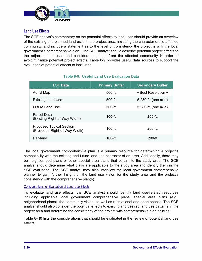
Land Use Effects The SCE analyst’s commentary on the potential effects to land uses should provide an overview of the existing and planned land uses in the project area, including the character of the affected community, and include a statement as to the level of consistency the project is with the local government’s comprehensive plan. The SCE analyst should describe potential project effects to the adjacent land uses and considers the input from the affected community in order to avoid/minimize potential project effects. Table 8-9 provides useful data sources to support the evaluation of potential effects to land uses.
Table 8-9: Useful Land Use Evaluation Data
EST Data Primary Buffer Secondary Buffer
Aerial Map 500-ft. ~ Best Resolution ~
Existing Land Use 500-ft. 5,280-ft. (one mile)
Future Land Use 500-ft. 5,280-ft. (one mile)
Parcel Data (Existing Right-of-Way Width)
100-ft. 200-ft.
Proposed Typical Section (Proposed Right-of-Way Width)
100-ft. 200-ft.
Parkland 100-ft. 200-ft
The local government comprehensive plan is a primary resource for determining a project’s compatibility with the existing and future land use character of an area. Additionally, there may be neighborhood plans or other special area plans that pertain to the study area. The SCE analyst should determine what plans are applicable to the study area and identify them in the SCE evaluation. The SCE analyst may also interview the local government comprehensive planner to gain further insight on the land use vision for the study area and the project’s consistency with the comprehensive plan(s).
Considerations for Evaluation of Land Use Effects
To evaluate land use effects, the SCE analyst should identify land use-related resources including applicable local government comprehensive plans, special area plans (e.g., neighborhood plans), the community vision, as well as recreational and open spaces. The SCE analyst should also consider the potential effects to existing and desired land use patterns in the project area and determine the consistency of the project with comprehensive plan policies.
Table 8–10 lists the considerations that should be evaluated in the review of potential land use effects.
ETDM Process Implementation Handbook 8-21
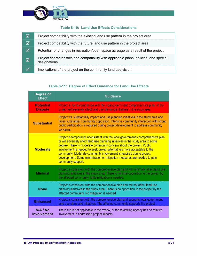
Table 8-10: Land Use Effects Considerations
Project compatibility with the existing land use pattern in the project area
Project compatibility with the future land use pattern in the project area
Potential for changes in recreation/open space acreage as a result of the project
Project characteristics and compatibility with applicable plans, policies, and special designations
Implications of the project on the community land use vision
Table 8-11: Degree of Effect Guidance for Land Use Effects
Degree of Effect
Guidance
Potential Dispute
Project is not in compliance with the local government comprehensive plan, or the project will severely affect land use planning initiatives in the study area.
Substantial
Project will substantially impact land use planning initiatives in the study area and faces substantial community opposition. Intensive community interaction with strong public participation is required during project development to address community concerns.
Moderate
Project is temporarily inconsistent with the local government’s comprehensive plan or will adversely affect land use planning initiatives in the study area to some degree. There is moderate community concern about the project. Public involvement is needed to seek project alternatives more acceptable to the community. Moderate community involvement is required during project development. Some minimization or mitigation measures are needed to gain community support.
Minimal Project is consistent with the comprehensive plan and will minimally affect land use planning initiatives in the study area. There is minimal opposition to the project by the affected community. Little mitigation is needed.
None Project is consistent with the comprehensive plan and will not affect land use planning initiatives in the study area. There is no opposition to the project by the affected community. No mitigation is needed.
Enhanced Project is consistent with the comprehensive plan and supports local government land use plans and initiatives. The affected community supports the project.
N/A / No Involvement
The issue is not applicable to the review, or the reviewing agency has no relative involvement in addressing project impacts.
8-22 Sociocultural Effects Evaluation
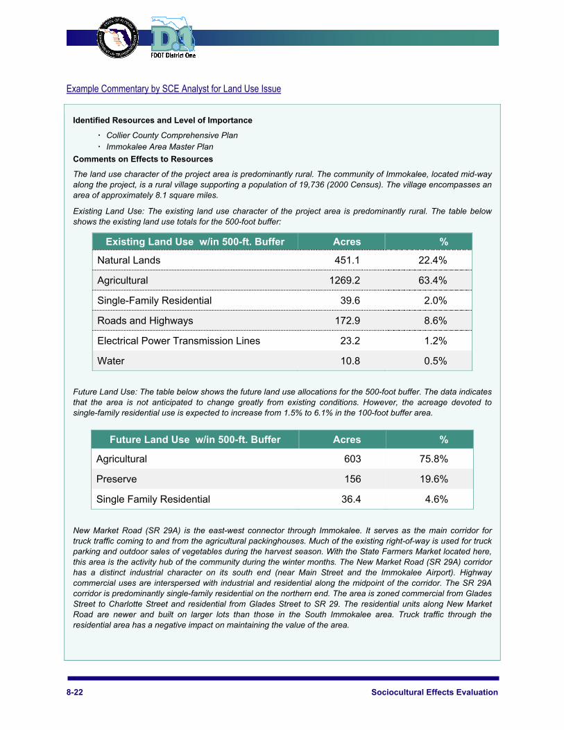
Example Commentary by SCE Analyst for Land Use Issue
Identified Resources and Level of Importance
Collier County Comprehensive Plan Immokalee Area Master Plan
Comments on Effects to Resources
The land use character of the project area is predominantly rural. The community of Immokalee, located mid-way along the project, is a rural village supporting a population of 19,736 (2000 Census). The village encompasses an area of approximately 8.1 square miles.
Existing Land Use: The existing land use character of the project area is predominantly rural. The table below shows the existing land use totals for the 500-foot buffer:
Existing Land Use w/in 500-ft. Buffer Acres %
Natural Lands 451.1 22.4%
Agricultural 1269.2 63.4%
Single-Family Residential 39.6 2.0%
Roads and Highways 172.9 8.6%
Electrical Power Transmission Lines 23.2 1.2%
Water 10.8 0.5%
Future Land Use: The table below shows the future land use allocations for the 500-foot buffer. The data indicates that the area is not anticipated to change greatly from existing conditions. However, the acreage devoted to single-family residential use is expected to increase from 1.5% to 6.1% in the 100-foot buffer area.
Future Land Use w/in 500-ft. Buffer Acres %
Agricultural 603 75.8%
Preserve 156 19.6%
Single Family Residential 36.4 4.6%
New Market Road (SR 29A) is the east-west connector through Immokalee. It serves as the main corridor for truck traffic coming to and from the agricultural packinghouses. Much of the existing right-of-way is used for truck parking and outdoor sales of vegetables during the harvest season. With the State Farmers Market located here, this area is the activity hub of the community during the winter months. The New Market Road (SR 29A) corridor has a distinct industrial character on its south end (near Main Street and the Immokalee Airport). Highway commercial uses are interspersed with industrial and residential along the midpoint of the corridor. The SR 29A corridor is predominantly single-family residential on the northern end. The area is zoned commercial from Glades Street to Charlotte Street and residential from Glades Street to SR 29. The residential units along New Market Road are newer and built on larger lots than those in the South Immokalee area. Truck traffic through the residential area has a negative impact on maintaining the value of the area.
ETDM Process Implementation Handbook 8-23
Immokalee has a designated Florida Main Street area that is anchored by the Seminole Indian Casino at the south end of town and the historic Roberts Ranch site on the west end of Main Street. The Main Street boundaries include the land adjacent to CR 846 (First Street) and SR 29 (Main Street). It is comprised predominantly of underutilized commercial lands including two vacant corners at First and Main streets, the primary intersection in town.
The approval of the Ave Maria Development of Regional Impact is anticipated in Spring 2005. The DRI is located approximately five miles west of SR 29 north of Oil Well Road and west of Camp Keais Road. At build out in 2016, this development is projected to contain 11,000 residential units, approximately 700,000 square feet of retail space, a 6,000 student Roman Catholic university and 510,000 square feet of office space.
The Collier County Growth Management Plan Future Land Use Map designates land along the project corridor as: Agricultural Rural Mixed Land Use District, Urban Residential District (Immokalee), Industrial District (Immokalee Airport Area), and Area of Critical State Concern. Additionally, the Immokalee Area Master Plan/Growth Management Plan (adopted 1991) coordinates land use and transportation planning, redevelopment or renewal of blighted areas, and elimination of land uses inconsistent with the community's character. The Immokalee Redevelopment Area mirrors the area included in the Immokalee area Master Plan.
The project is not consistent with the applicable local government comprehensive plan, which shows only a portion of the project as a four-lane facility on the plan’s future year transportation map. It is recommended that the District and MPO coordinate with the county determine the intent to amend the comprehensive plan in order to amend the future year transportation map to show the entire project as a four-lane facility.
No loss of recreation/open space lands are anticipated to occur as a result of right-of-way acquisition for the project.
CLC Commitments and Recommendations
It is recommended that community outreach be conducted to solicit feedback on potential effects to land uses along SR 29A and the remainder of the SR 29 corridor as a result of the project.

8-24 Sociocultural Effects Evaluation
Mobility Effects The SCE analyst should consider both the driving and the non-driving population groups including the elderly, young, disabled, and low-income individuals in evaluating the potential for project effects on mobility and accessibility in the affected community. The SCE analyst should also explore the potential for project-related effects on connectivity between neighborhoods and significant community focal points, the ability of non-drivers to access businesses and services, access to public transportation, pedestrian and bicycle mobility, intermodal connectivity, traffic patterns, and public parking areas. Table 8-12 lists relevant data sources that can inform the evaluation.
Table 8-12: Useful Mobility Evaluation Data
EST Data Primary Buffer Secondary
Buffer
Existing Land Use 100-ft. 200-ft.
Community Focal Points 100-ft. 200-ft.
Sidewalks 100-ft. 200-ft.
Long Range Transportation Plan N/A N/A
Trails (existing and planned) 100-ft. 200-ft.
Transit Service 100-ft. 200-ft.
Pedestrian and Bicycle Plans N/A N/A
Assessment of the goals and objectives in the respective LRTP relative to mobility and accessibility throughout the county and region may provide more insight regarding potential project effects.
Considerations for Evaluation of Mobility Effects
To evaluate mobility effects, the SCE analyst should consider the existing transportation facilities and services; characteristics and features in the project area that have bearing on mobility; transportation disadvantaged population groups in the project area; and relevant transportation plans. The SCE analyst should additionally consider the project’s relevance in meeting local and regional mobility needs such as hurricane evacuation. Table 8–13 lists the mobility considerations that should be evaluated.
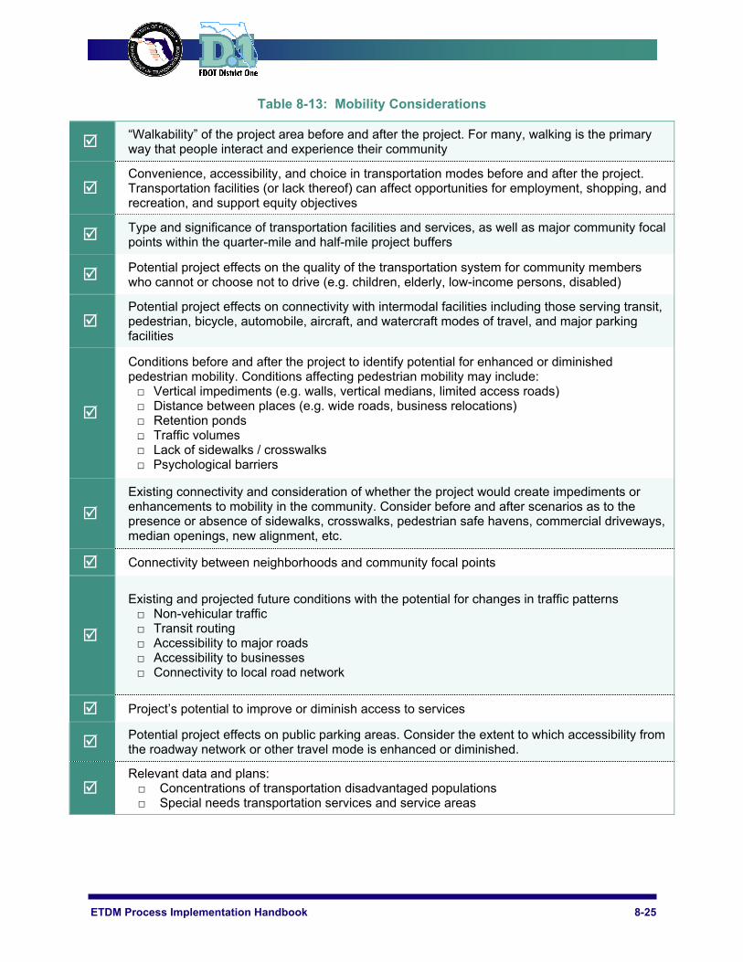
ETDM Process Implementation Handbook 8-25
Table 8-13: Mobility Considerations
“Walkability” of the project area before and after the project. For many, walking is the primary way that people interact and experience their community
Convenience, accessibility, and choice in transportation modes before and after the project. Transportation facilities (or lack thereof) can affect opportunities for employment, shopping, and recreation, and support equity objectives
Type and significance of transportation facilities and services, as well as major community focal points within the quarter-mile and half-mile project buffers
Potential project effects on the quality of the transportation system for community members who cannot or choose not to drive (e.g. children, elderly, low-income persons, disabled)
Potential project effects on connectivity with intermodal facilities including those serving transit, pedestrian, bicycle, automobile, aircraft, and watercraft modes of travel, and major parking facilities
Conditions before and after the project to identify potential for enhanced or diminished pedestrian mobility. Conditions affecting pedestrian mobility may include: □ Vertical impediments (e.g. walls, vertical medians, limited access roads) □ Distance between places (e.g. wide roads, business relocations) □ Retention ponds □ Traffic volumes □ Lack of sidewalks / crosswalks □ Psychological barriers
Existing connectivity and consideration of whether the project would create impediments or enhancements to mobility in the community. Consider before and after scenarios as to the presence or absence of sidewalks, crosswalks, pedestrian safe havens, commercial driveways, median openings, new alignment, etc.
Connectivity between neighborhoods and community focal points
Existing and projected future conditions with the potential for changes in traffic patterns □ Non-vehicular traffic □ Transit routing □ Accessibility to major roads □ Accessibility to businesses □ Connectivity to local road network
Project’s potential to improve or diminish access to services
Potential project effects on public parking areas. Consider the extent to which accessibility from the roadway network or other travel mode is enhanced or diminished.
Relevant data and plans: □ Concentrations of transportation disadvantaged populations □ Special needs transportation services and service areas

8-26 Sociocultural Effects Evaluation
Table 8-14: Degree of Effect Guidance for Mobility Effects
Degree of Effect
Guidance
Potential Dispute
Project is not in compliance with the local government comprehensive plan or will severely affect mobility and/or accessibility between people and places in the affected community.
Substantial
Project will substantially affect mobility and/or accessibility between people and places in the affected community and faces substantial community opposition. Intensive community interaction with strong public participation is required during project development to address community concerns.
Moderate
Project will adversely affect mobility and/or accessibility between people and places in the affected community to some degree. There is moderate community concern about the project. Public involvement is needed to seek project alternatives more acceptable to the community. Moderate community involvement is required during project development. Some minimization or mitigation measures are needed to gain community support.
Minimal Project will minimally impact mobility and/or accessibility between people and places in the affected community. There is minimal opposition to the project by the affected community. Little mitigation is needed.
None Project will not impact mobility and/or accessibility between people and places in the affected community. There is no opposition to the project by the affected community. No mitigation is needed.
Enhanced The project is in concert with a community-endorsed plan or program that will enhance mobility and/or accessibility between people and places in the affected community. The affected community supports the project.
N/A / No Involvement
The issue is not applicable to the review, or the reviewing agency has no relative involvement in addressing project impacts.

ETDM Process Implementation Handbook 8-27
Example Commentary by SCE Analyst for Mobility Issue
Identified Resources and Level of Importance
100-Foot Buffer: Trolley Route Greenway Ecological Priority Linkage (medium priority)
500-Foot Buffer: Bus routes 9, 16, & 19
Comments on Effects to Resources
This is a capacity improvement project that would add one lane in each direction to the existing 4-lane US 41 corridor, from Sumter Boulevard to SR 776 (Englewood Road), creating a 6-lane roadway. This project segment is located in the southern portion of Sarasota County and connects with project #3204, widening of US 41 from Enterprise Drive (Charlotte County) to Sumter Boulevard.
US 41 is an important parallel facility to Interstate 75 and a major north-south arterial connecting Sarasota, Manatee and Charlotte County. This capacity improvement project will accommodate increases in roadway demand generated by regional population growth, as well as provide relief for congestion on Interstate 75. It will also provide enhanced access between the cities of South Venice and North Port and aid emergency evacuation of the region’s population.
US 41 is a critical link in the Sarasota County Emergency Management Department’s hurricane evacuation route network. The capacity improvement of US 41 from SR 776 to Sumter Boulevard will aid in the evacuation of nearby residents in the event of an emergency. Safety, emergency access, and truck access will all be enhanced through this corridor improvement.
According to the Sarasota County 2025 Long Range Transportation Plan, transit service exists along US 41 from SR 776 (Englewood Road) roughly to the Sumter Boulevard intersection. This service is expected to continue in the future. Additionally, the Sarasota-Manatee 2025 Bicycle Needs Plan map shows portions of US 41 and Sumter Boulevard with a grade-separated bicycle facility near where the roadways intersect. No additional bike lanes are planned for this segment of US 41 roadway. According to the Sarasota Comprehensive Plan, a separate bicycle and pedestrian pathway exists along US 41 from River Road to Sumter Boulevard. Sidewalk facilities are present along US 41 from SR 776 slightly past Jacaranda Boulevard and pick up again at River Road and extend towards Sumter Boulevard. No other pedestrian facilities are planned for this roadway.
CLC Commitments and Recommendations
The project would likely improve motor vehicle mobility and provide relief for congestion on Interstate 75. The corridor widening will likely provide for enhanced efficiency for cars, trucks and transit, while also improving emergency access. To avoid potential effects to other modes of travel, such as walking and cycling, it is recommended that a public outreach effort be conducted to solicit community opinion and preferences relative to mobility needs along the corridor. For instance, population growth may indicate a need for enhanced non-motorized transportation facilities in the study area.

8-28 Sociocultural Effects Evaluation
Aesthetic Effects Aesthetics is a context-sensitive phenomenon because it is a matter of subjective taste. As such, the aesthetic character of a community is intimately tied to its identity, culture, and community goals, as well as many other factors and subtleties. While the SCE analyst may have a hard time explaining aesthetic values, most individuals can easily regard something as beautiful/ugly, exciting/boring, or comforting/foreign. Table 8-15 lists aesthetic resources to be considered by the SCE analyst during the evaluation.
Table 8-15: Useful Data for Evaluation of Aesthetic Effects
EST Data Primary Buffer
Secondary Buffer
Aerial Photography 500-ft. ~ Best
Resolution ~
Parcel Data (Existing Right-of-Way) 100-ft. 200-ft.
Proposed Typical Section (Proposed Right-of-Way) 100-ft. 200-ft.
Residential Areas 100-ft. 200-ft.
Points of Interest 100-ft. 200-ft.
Water Features 100-ft. 200-ft.
Hospitals 100-ft. 200-ft.
Heath Care Facilities 100-ft. 200-ft.
Noise Barriers 100-ft. 200-ft.
Field Data: □ Highway Beautification □ Streetscaping □ Distinctive (of a certain time period) Architecture □ Distinctive (of a certain philosophy or practice)
Urban Design
100-ft. 200-ft.
Special Designations: □ Florida Main Street □ Historic District □ Community Redevelopment Area □ Front Porch Community □ Land Use / Zoning Overlay District
100-ft. 200-ft.
ETDM Process Implementation Handbook 8-29
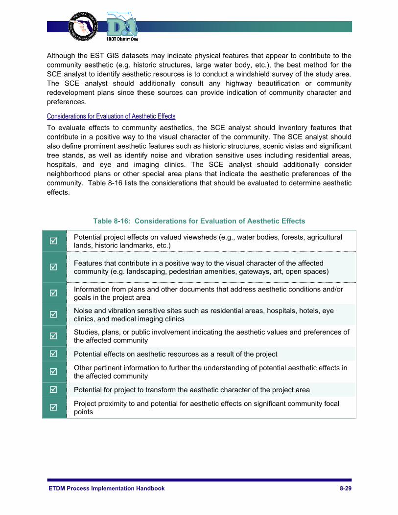
Although the EST GIS datasets may indicate physical features that appear to contribute to the community aesthetic (e.g. historic structures, large water body, etc.), the best method for the SCE analyst to identify aesthetic resources is to conduct a windshield survey of the study area. The SCE analyst should additionally consult any highway beautification or community redevelopment plans since these sources can provide indication of community character and preferences.
Considerations for Evaluation of Aesthetic Effects
To evaluate effects to community aesthetics, the SCE analyst should inventory features that contribute in a positive way to the visual character of the community. The SCE analyst should also define prominent aesthetic features such as historic structures, scenic vistas and significant tree stands, as well as identify noise and vibration sensitive uses including residential areas, hospitals, and eye and imaging clinics. The SCE analyst should additionally consider neighborhood plans or other special area plans that indicate the aesthetic preferences of the community. Table 8-16 lists the considerations that should be evaluated to determine aesthetic effects.
Table 8-16: Considerations for Evaluation of Aesthetic Effects
Potential project effects on valued viewsheds (e.g., water bodies, forests, agricultural lands, historic landmarks, etc.)
Features that contribute in a positive way to the visual character of the affected community (e.g. landscaping, pedestrian amenities, gateways, art, open spaces)
Information from plans and other documents that address aesthetic conditions and/or goals in the project area
Noise and vibration sensitive sites such as residential areas, hospitals, hotels, eye clinics, and medical imaging clinics
Studies, plans, or public involvement indicating the aesthetic values and preferences of the affected community
Potential effects on aesthetic resources as a result of the project
Other pertinent information to further the understanding of potential aesthetic effects in the affected community
Potential for project to transform the aesthetic character of the project area
Project proximity to and potential for aesthetic effects on significant community focal points

8-30 Sociocultural Effects Evaluation
Table 8-17: Degree of Effect Guidance for Aesthetic Effects
Degree of Effect
Guidance
Potential Dispute
Project is not in compliance with the local government comprehensive plan or the project will cause severe community effects due to the degree of adverse physical change caused by the project.
Substantial
Project will substantially affect the aesthetics of the community due to adverse physical changes and faces substantial community opposition. Intensive community interaction with focused public involvement is required during project development to address community concerns.
Moderate
Project will moderately affect the aesthetics of the community due to some physical changes. Public involvement is needed to seek alternatives more acceptable to the community. Moderate community involvement is required during project development. Some minimization or mitigation is needed to gain support from the community.
Minimal Project will minimally impact community aesthetics. There is minimal opposition to the project by the affected community. Little mitigation is needed.
None Project will not impact community aesthetics. There is no opposition to the project by the affected community. No mitigation is needed.
Enhanced Project is in concert with a community-endorsed plan or program that will enhance the aesthetics of the affected community. The affected community supports the project
N/A / No Involvement
The issue is not applicable to the review, or the reviewing agency has no relative involvement in addressing project impacts.
ETDM Process Implementation Handbook 8-31
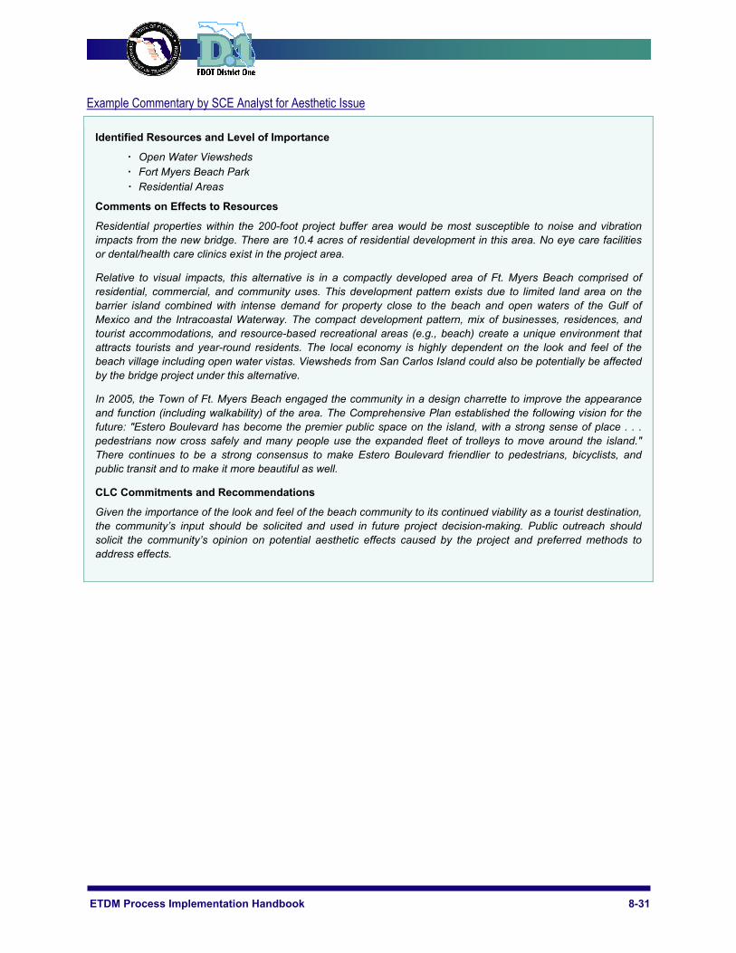
Example Commentary by SCE Analyst for Aesthetic Issue
Identified Resources and Level of Importance
Open Water Viewsheds Fort Myers Beach Park Residential Areas
Comments on Effects to Resources
Residential properties within the 200-foot project buffer area would be most susceptible to noise and vibration impacts from the new bridge. There are 10.4 acres of residential development in this area. No eye care facilities or dental/health care clinics exist in the project area.
Relative to visual impacts, this alternative is in a compactly developed area of Ft. Myers Beach comprised of residential, commercial, and community uses. This development pattern exists due to limited land area on the barrier island combined with intense demand for property close to the beach and open waters of the Gulf of Mexico and the Intracoastal Waterway. The compact development pattern, mix of businesses, residences, and tourist accommodations, and resource-based recreational areas (e.g., beach) create a unique environment that attracts tourists and year-round residents. The local economy is highly dependent on the look and feel of the beach village including open water vistas. Viewsheds from San Carlos Island could also be potentially be affected by the bridge project under this alternative.
In 2005, the Town of Ft. Myers Beach engaged the community in a design charrette to improve the appearance and function (including walkability) of the area. The Comprehensive Plan established the following vision for the future: "Estero Boulevard has become the premier public space on the island, with a strong sense of place . . . pedestrians now cross safely and many people use the expanded fleet of trolleys to move around the island." There continues to be a strong consensus to make Estero Boulevard friendlier to pedestrians, bicyclists, and public transit and to make it more beautiful as well.
CLC Commitments and Recommendations
Given the importance of the look and feel of the beach community to its continued viability as a tourist destination, the community’s input should be solicited and used in future project decision-making. Public outreach should solicit the community’s opinion on potential aesthetic effects caused by the project and preferred methods to address effects.
8-32 Sociocultural Effects Evaluation
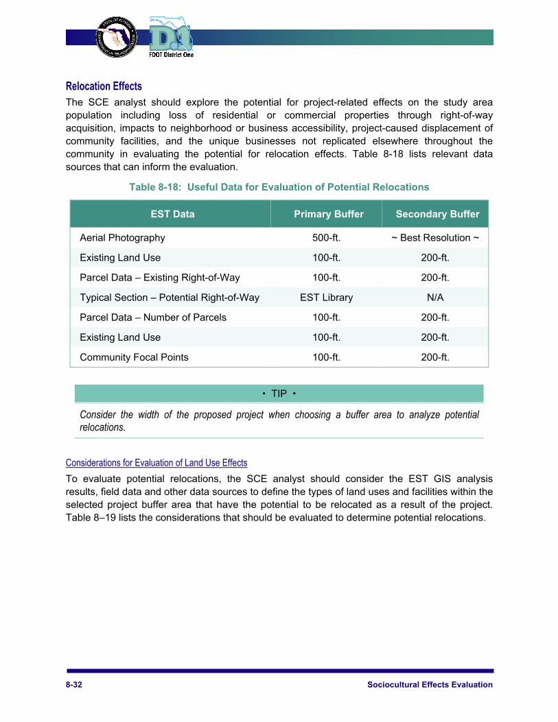
Relocation Effects The SCE analyst should explore the potential for project-related effects on the study area population including loss of residential or commercial properties through right-of-way acquisition, impacts to neighborhood or business accessibility, project-caused displacement of community facilities, and the unique businesses not replicated elsewhere throughout the community in evaluating the potential for relocation effects. Table 8-18 lists relevant data sources that can inform the evaluation.
Table 8-18: Useful Data for Evaluation of Potential Relocations
EST Data Primary Buffer Secondary Buffer
Aerial Photography 500-ft. ~ Best Resolution ~
Existing Land Use 100-ft. 200-ft.
Parcel Data – Existing Right-of-Way 100-ft. 200-ft.
Typical Section – Potential Right-of-Way EST Library N/A
Parcel Data – Number of Parcels 100-ft. 200-ft.
Existing Land Use 100-ft. 200-ft.
Community Focal Points 100-ft. 200-ft.
TIP
Consider the width of the proposed project when choosing a buffer area to analyze potential relocations.
Considerations for Evaluation of Land Use Effects
To evaluate potential relocations, the SCE analyst should consider the EST GIS analysis results, field data and other data sources to define the types of land uses and facilities within the selected project buffer area that have the potential to be relocated as a result of the project. Table 8–19 lists the considerations that should be evaluated to determine potential relocations.
ETDM Process Implementation Handbook 8-33
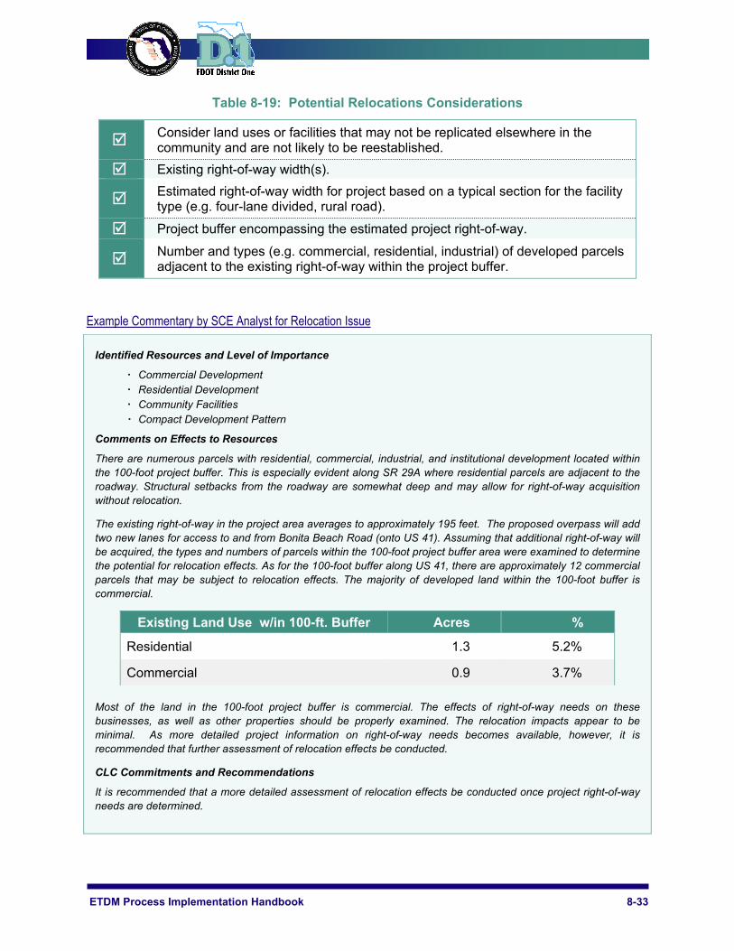
Table 8-19: Potential Relocations Considerations
Consider land uses or facilities that may not be replicated elsewhere in the community and are not likely to be reestablished.
Existing right-of-way width(s).
Estimated right-of-way width for project based on a typical section for the facility type (e.g. four-lane divided, rural road).
Project buffer encompassing the estimated project right-of-way.
Number and types (e.g. commercial, residential, industrial) of developed parcels adjacent to the existing right-of-way within the project buffer.
Example Commentary by SCE Analyst for Relocation Issue
Identified Resources and Level of Importance
Commercial Development Residential Development Community Facilities Compact Development Pattern
Comments on Effects to Resources
There are numerous parcels with residential, commercial, industrial, and institutional development located within the 100-foot project buffer. This is especially evident along SR 29A where residential parcels are adjacent to the roadway. Structural setbacks from the roadway are somewhat deep and may allow for right-of-way acquisition without relocation.
The existing right-of-way in the project area averages to approximately 195 feet. The proposed overpass will add two new lanes for access to and from Bonita Beach Road (onto US 41). Assuming that additional right-of-way will be acquired, the types and numbers of parcels within the 100-foot project buffer area were examined to determine the potential for relocation effects. As for the 100-foot buffer along US 41, there are approximately 12 commercial parcels that may be subject to relocation effects. The majority of developed land within the 100-foot buffer is commercial.
Existing Land Use w/in 100-ft. Buffer Acres %
Residential 1.3 5.2%
Commercial 0.9 3.7%
Most of the land in the 100-foot project buffer is commercial. The effects of right-of-way needs on these businesses, as well as other properties should be properly examined. The relocation impacts appear to be minimal. As more detailed project information on right-of-way needs becomes available, however, it is recommended that further assessment of relocation effects be conducted.
CLC Commitments and Recommendations
It is recommended that a more detailed assessment of relocation effects be conducted once project right-of-way needs are determined.

8-34 Sociocultural Effects Evaluation
8.3 Summary Report As previously mentioned, the evaluation of sociocultural resource issues by the District One ETDM Coordinator and support team occurs with the preparation of the project Summary Report. The Summary Report outlines conclusions and key recommendations associated with a transportation project for all twenty-one ETDM issues. This report may include short quotes from the ETAT commentary to support a specific issue (it should not include a verbatim copy of the entire ETAT commentary) and should be generated within 60 days after the close of the project review period. In general, the commentary is reviewed and where there are varying DOEs assigned to an issue, the District One ETDM Coordinator determines a Summary DOE and basis for the decision.
The Summary Report for Planning and Programming Screens vary in that the Programming Screen Summary Report includes: 1) a more detailed assessment of potential impacts to resources; 2) identification of required technical studies and permits; 3) recommendations for avoidance, minimization, and/or mitigation; and 4) methods to resolve potential disputes, if necessary. The published Summary Reports are made available to all ETAT members and, once published, may be obtained through the Public Access site (http://etdmpub.fla-etat.org/est/).
Planning Screen Summary Report
The purpose of a Planning Screen Summary Report is to identify and document fatal flaws or controversies that will prevent the project from moving forward or that will require adjustments to the project concept. To prepare this report, the following steps should be conducted by the District One ETDM Coordinator for each sociocultural resource issue:
Review the Project Description and Purpose and Need Statement in the EST to fully understand the project scope
Review ETAT commentary for each sociocultural resource issue Choose a project buffer(s) appropriate to the project location and scope and review EST
GIS data/analysis results for selected buffer(s) Review pertinent information not available in the EST (e.g. community plans,
comprehensive plans, policies, or public outreach initiatives) Contact agency(ies) to clarify/better understand potential effects/issues; Synthesize ETAT comments for each sociocultural resource issue Assign a Summary DOE and prepare coordinator commentary justifying the assigned
Summary DOE based on ETAT commentary, community initiatives, EST GIS data/results, and professional knowledge
Recommend targeted agency coordination to understand the magnitude of potential project effects and to determine the methods for addressing impacts
Programming Screen Summary Report
A Programming Screen Summary Report includes updated information regarding potential project effects to natural resources based on new data, public input, and more detailed agency input. This report also includes project-specific commitments and responses provided by the District One ETDM Coordinator, along with technical studies and special permits anticipated to be required during the Project Development phase. To prepare this report, the following steps
ETDM Process Implementation Handbook 8-35
should be conducted by the District One ETDM Coordinator for each sociocultural resource issue:
Review the Planning Screen Summary Report to understand changes in the project scope and any previously identified issues/controversies to still be addressed
Review new ETAT commentary for each sociocultural resource issue Choose a project buffer(s) appropriate to the project location and scope and review new
EST GIS data/analysis results for selected buffer(s)* Review any new pertinent information not available in the EST (i.e., agency
resource/conservation plans, policies, or initiatives and new/updated site-specific data) Contact resource agency(ies) to clarify/better understand potential project effects and
identify anticipated coordination issues/regulatory constraints Synthesize ETAT comments for each sociocultural resource issue Assign a Summary DOE and prepare coordinator commentary justifying the assigned
Summary DOE based on updated ETAT commentary, community initiatives, EST GIS data/results, and professional knowledge
Provide scoping recommendations and define, if required, the level of technical study to be performed and specific permit(s) needed (note: technical studies and permits may not be required for every issue; it will depend on the nature and location of the project)
Recommend targeted agency coordination to further understand the magnitude of potential project effects, evaluate possible design measures for avoiding and minimizing impacts, and establish methods for addressing unavoidable impacts
To prepare the District One ETDM Coordinator commentary for each sociocultural resource issue as part of the Summary Report, the District One ETDM Coordinator and support team should follow the considerations outlined in the previous part of Chapter 8. Again, the commentaries encompass the synthesized ETAT member comments and justification/ supporting arguments for the assigned Summary DOE. Project-specific commitments and responses, as well as required technical studies and permits (if applicable), are only identified for Programming Screen Summary Reports. Sample District One ETDM Coordinator commentary is presented below for each of the six sociocultural resource issues. The provided commentaries reflect those provided for Programming Screen Summary Reports.
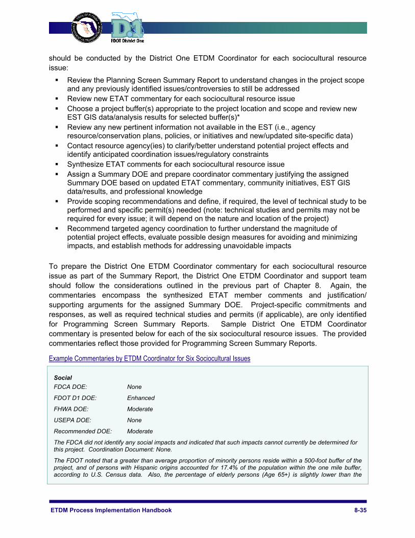
Example Commentaries by ETDM Coordinator for Six Sociocultural Issues
Social FDCA DOE: None
FDOT D1 DOE: Enhanced
FHWA DOE: Moderate
USEPA DOE: None
Recommended DOE: Moderate
The FDCA did not identify any social impacts and indicated that such impacts cannot currently be determined for this project. Coordination Document: None.
The FDOT noted that a greater than average proportion of minority persons reside within a 500-foot buffer of the project, and of persons with Hispanic origins accounted for 17.4% of the population within the one mile buffer, according to U.S. Census data. Also, the percentage of elderly persons (Age 65+) is slightly lower than the

8-36 Sociocultural Effects Evaluation
County average (17.1% versus 19%) and the percentages of youth (Under age 18) as well as the median family income are slightly higher than the County average (24.6% versus 22.7% and $38,735 versus $34,726, respectively). The incorporated City of Arcadia, located within one mile of the southern limits of the project, is the primary urban area within proximity and includes community resources such as community centers, cultural centers and religious institutions. The FDOT indicated that the project will enhance mobility and accessibility for transportation disadvantaged persons and recreational cyclists/joggers. In addition, it will likely enhance opportunities for social interaction among residents and tourists alike. Public outreach activities during project development should be conducted in both English and Spanish languages. Coordination Document: None.
The FHWA identified that within the 100' buffer are portions of three Census Data Block Groups. All Block Groups appear to have low density populations. However, Group #120279802001 is 20% Hispanic, Group #120279804011 is 26% Hispanic, and Group #120279801001 is 36% Hispanic with a Poverty Index of 1.97 (approx. income is $30,000 per year). Any disproportionate project impacts to low income and minority populations may involve environmental justice issues. The project will need a Sociocultural Effects Analysis. Coordination Document: PD&E Support Document as per PD&E Manual.
The USEPA did not identify any social issues associated with this project. Coordination Document: None
In addition to the obvious recreation opportunities presented by the project, the Peace River Greenway offers an alternative, non-motorized transportation option for area residents (both permanent and temporary) to access nearby parks as well as community resources within the City of Arcadia. The project could provide additional recreation opportunities and enhance mobility and accessibility for transportation disadvantaged persons. Due to the high percentage of persons claiming Hispanic ethnicity, public outreach activities during project development should be conducted in both English and Spanish languages. Also, any disproportionate project impacts to low income and minority populations may involve environmental justice issues. Therefore, a Summary DOE of Moderate has been assigned to the Social issue.
Commitments and Responses: A Sociocultural Effects Analysis will be included in the scoping recommendations for the project.
Economic FDOT D1 DOE: Enhanced
Recommended DOE: Enhanced
The FDOT commented that within the SR 80 corridor, population is projected to grow approximately 4.8% annually; employment is expected to increase by 15.4% annually. In addition, the region is expected to experience a significant increase in population and employment when compared to countywide growth rates. The FDOT stated that the expansion of SR 80 from four to six lanes will be critical in responding to growth in northern Lee County, as well as enhancing goods movement in the region. Coordination Document: None
For these reasons, a Summary DOE of Enhanced has been assigned to the Economic issue.
Commitments and Responses: None
Land Use FDCA DOE: Minimal
FDOT D1 DOE: Minimal
Recommended DOE: Minimal
FDCA has no issues with the project and indicates support for the use of congestion management techniques in lieu of widening where appropriate. The FDCA also supports alternative modes of transportation such as bicycles, walking and transit. Coordination Document: None
The FDOT reported that this project is reflected on Lee County’s Comprehensive Plan, Future Transportation Map, but not on Collier County’s Financially Feasible Map. The FDOT stated that coordination with the county indicates that the project will be amended into the plan update, if it does move forward. Coordination Document: None
For these reasons, a Summary DOE of Minimal is assigned to the Land Use issue.

ETDM Process Implementation Handbook 8-37
Commitments and Responses: None
Mobility Collier County MPO DOE: Minimal
Recommended DOE: Minimal
Collier County MPO indicated that SR 951 is a primary evacuation route and one of only two routes off of Marco Island. The MPO also stated that public commentary reflects the general feeling that the project will have minimal impact unless the Marco Island Bridge expansion is carried out. The MPO recommends exploring additional mobility options should be explored during the update of the LRTP. Coordination Document: None
Based on the foregoing, a Summary DOE of Minimal has been assigned to the Mobility issue.
Commitments and Responses: None
Aesthetics
FDOT D1 DOE: Minimal
Recommended DOE: Minimal
The FDOT indicated that impacts will likely be minimal; however, the university town center and campus will likely generate interest in the community regarding the aesthetics of the development. The FDOT stated that there are no existing residences or community resources in the area; thus, noise and vibration related impacts will also likely be minimal. Coordination Document: None
Based on theforegoing, a Summary DOE of Minimal has been assigned to the Aesthetics issue.
Commitments and Responses: None
Relocation FDOT D1 DOE: Moderate
FHWA DOE: Minimal
Recommended DOE: Moderate
The FDOT indicated that there are some large-lot single family residences along either side of the Peace River and few business properties in the project area. It is not clear how much additional right-of-way (if any) will be needed for the project. However, due to the existing residential properties that extend to the river's edge along a portion of the project corridor, property impacts and the potential for relocations are expected to be moderate. As more detailed project information on right-of-way needs becomes available, it is recommended that further assessment of relocation effects be conducted. Coordination Document: None.
The FHWA indicated that there are 30 acres of low density residential area within the 100-foot buffer as well as Progressive Baptist Church. If residents or businesses require relocation, a ROW and relocation program in accordance with the Uniform Relocation Assistance and Real Property Acquisition Policies Act of 1970 (Public Law 91-646 as amended by Public Law 100-17) will need to be carried out. Coordination Document: PD&E Support Document as per PD&E Manual.
The project appears to limit the potential need for residential property acquisition by utilizing existing roadways near the river and avoiding direct property crossings along the river's edge; however, some property acquisition looks inevitable and it isn’t clear how much additional right-of-way will be required. Therefore, a Summary DOE of Moderate has been assigned to the Relocation issue.
Commitments and Responses: None.