uptown regional bike corridor project tier ii alternatives
TRANSCRIPT
Uptown Regional Bike Corridor Project Tier II –Alternatives Analysis
1
Introduction
The purpose of the Tier II Alternatives Analysis was to evaluate the 25 alignments resulting from the
Tier I evaluation. The highest ranking alignments from Tier II analysis are recommended for the Tier III
analysis.
Tier I Summary
The alternatives for the Uptown Regional Bike Corridor Project were developed starting with the
corridors identified in the SANDAG Regional Bike Plan (Bike Plan) and incorporating additional
alignments based on community input.
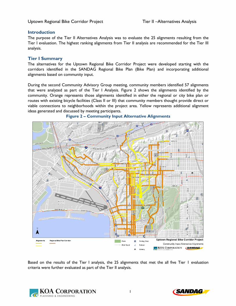
During the second Community Advisory Group meeting, community members identified 57 alignments
that were analyzed as part of the Tier I Analysis. Figure 2 shows the alignments identified by the
community. Orange represents those alignments identified in either the regional or city bike plan or
routes with existing bicycle facilities (Class II or III) that community members thought provide direct or
viable connections to neighborhoods within the project area. Yellow represents additional alignment
ideas generated and discussed by meeting participants.
Figure 2 – Community Input Alternative Alignments
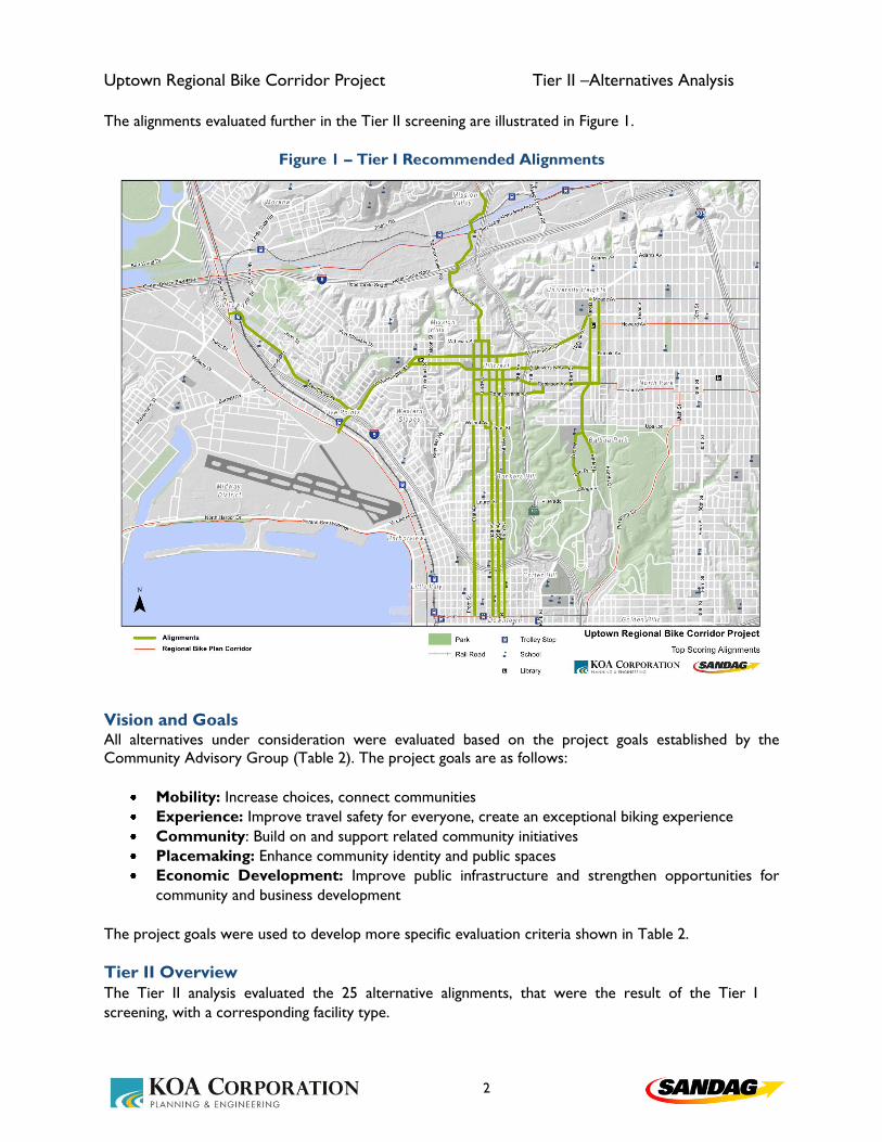
Based on the results of the Tier I analysis, the 25 alignments that met the all five Tier 1 evaluation
criteria were further evaluated as part of the Tier II analysis.
Uptown Regional Bike Corridor Project Tier II –Alternatives Analysis
2
The alignments evaluated further in the Tier II screening are illustrated in Figure 1.
Figure 1 – Tier I Recommended Alignments
Vision and Goals All alternatives under consideration were evaluated based on the project goals established by the
Community Advisory Group (Table 2). The project goals are as follows:
Mobility: Increase choices, connect communities
Experience: Improve travel safety for everyone, create an exceptional biking experience
Community: Build on and support related community initiatives
Placemaking: Enhance community identity and public spaces
Economic Development: Improve public infrastructure and strengthen opportunities for
community and business development
The project goals were used to develop more specific evaluation criteria shown in Table 2.
Tier II Overview
The Tier II analysis evaluated the 25 alternative alignments, that were the result of the Tier I
screening, with a corresponding facility type.

Uptown Regional Bike Corridor Project Tier II –Alternatives Analysis
3
During the design concept process, Robinson Ave, and University Ave alignments in the Hillcrest-
Hillcrest and Hillcrest-North Park corridors and Park Blvd in the University Heights-Balboa Park
corridor were further developed into constrained and unconstrained alternatives to consider
potential impacts to traffic operations and parking. This increased the number of alignments analyzed
to 30. With the constrained alternatives, both existing parking and vehicular travel lanes were
preserved. With the unconstrained alternatives, parking and/or vehicular travel lanes were reduced
to accommodate dedicated bicycle facilities. Table 1 summarizes each alignment evaluated and its
respective facility type.
Table 1 – Alignments and Facility Types
Mission Valley - Hillcrest Hotel Circle/Bachman PlMulti-use path (Ulric) - Two-way cycle track (Cno de la Reina) - Two way buffered bike
lanes (I-8 Underpass) - Sharrow/bike lane (Bachman NB/SB)
1st Bike lanes
3rd/Upas Shared facility
4th Two-way cycle track
5th Two-way cycle track
6th One-way cycle track & buffered bike lane
1st One-way cycle track
4th One-way cycle track
5th One-way cycle track
6th One-way cycle track
Old Town - Five Points Congress/San Diego Ave Shared facility (Congress St)- Buffered bike lane (San Diego Ave)
Five Points - Mission Hills Washington Ave Buffered bike lane & bike/ped sidepath
Washington Ave Buffered bike lanes
University Ave Bike Boulevard
Washington Ave Buffered bike lanes
University Ave
Constrained Shared facility (Front-5th, Normal-Park) - bike lanes (5th-9th)
Unconstrained Cycle track (Front-3rd, 4th-9th)
Robinson Ave
Constrained Shared facility (1st-8th)
Unconstrained Cycle track (4th-8th)
Pennsylvania Ave Bike Boulevard
Washington Ave Buffered bike lanes
University Ave
Constrained Buffered bike lanes (9th-10th) - bike/ped sidepath (10th-Normal)
UnconstrainedCycle track (Vermont-Normal, Centre-Park)
bike/ped sidepath (Normal-Centre, at Park)
Robinson Ave
ConstrainedShared facility (SR-163 bridge WB) - Bike lane (SR-163 bridge EB)
Buffered bike lanes (10th-Park)
Unconstrained Buffered bike lanes (SR-163 bridge)
Pennsylvania Ave Bike Boulevard
Park Blvd
Constrained Shared facility (Adams-Meade, El Cajon-Lincoln) - Bike lanes (Meade-El Cajon)
Unconstrained Cycle track (Meade-Upas) - bike/ped sidepath (Upas-Zoo)
Georgia St Bike Boulevard
Bankers Hill - Downtown
University Heights - Balboa Park
Corridor Alignment Facility Description
Hillcrest - Bankers Hill
Hillcrest - North Park
Hillcrest - Hillcrest
Mission Hills - Hillcrest

Uptown Regional Bike Corridor Project Tier II –Alternatives Analysis
4
The Tier II analysis involved a quantitative evaluation of the alignments based on seven evaluation
criteria. The evaluation criteria and their corresponding performance measures were scored on a
scale of zero to two. The evaluation criteria were applied relative to other alignments in the same
corridor. For example, the alignment on Washington Street in the Mission Hills–Hillcrest corridor
was evaluated against the University Avenue alignment in the same corridor. However, it was not
compared to the Pennsylvania Avenue alignment in the Hillcrest–North Park corridor.
Table 2 summarizes the evaluation criteria that were used in the analysis of alternatives alignments,
the description of each criterion, and the associated scoring measures. Regional connectivity,
neighborhood connectivity, and independent utility were Tier I analysis criteria. If alignments score
“yes” for these criteria, they were evaluated in the Tier II analysis.
The route concepts to each alignment can be found in Appendix A.

Uptown Regional Bike Corridor Project Tier II –Alternatives Analysis
5
Table 2 – Evaluation Criteria
Evaluation Criteria
Project Goal Criteria Description Scoring Measure
Regional Connectivity Does the proposed alignment connect two or
more regional corridors identified in the
Regional Bike Plan?
(Yes/No)
City Plan Connectivity Does the proposed alignment compliment the
City of San Diego Bike Plan?
(Yes/No)
Neighborhood Connectivity Does the proposed alignment connect two or
more project area neighborhood nodes?
(Yes/No)
Deficiency Is there an existing deficiency that the
alignment is addressing?
- Alignment has no facility.
- Alignment has a facility, but facility doesn't serve average
person, therefore, it is not adequate.
- A parallel alignment has adequate facilities.
- Alignment has adequate facilities.
Independent Utility Does the alignment have independent utility
(i.e. does it make sense as a stand alone
project)?
(Yes/No)
Couplet Clossness Is the proposed alignment close to the
proposed couplet?. It only applies to
competing alignments on the same corridor
where a couplet is proposed.
(Yes/No)
Directness Is the proposed alignment a direct alignment
to the regional or neighborhood connection?
(Yes/No)
Multimodal Connectivity Ability to transfer to various transit modes
(bus, trolley, train, shuttle service).
- High number of transit nodes connected to alignment.
- Medium number of transit nodes connected to alignment.
- Low number of transit nodes connected to alignment.
Activity Center Proximity Are there proximate activity centers along the
alignment?
- High number of activity centers within 2 blocks of alignment.
- Medium number of activity centers within 2 blocks of
alignment.
- Low number of activity centers within 2 blocks of alignment.
Population Population served by connected LTS network. - High number of people connected to through LTS 1 & 2
streets and people on the alignment.
'- Medium number of people connected to through LTS 1 & 2
streets and people on the alignment.
'- Low number of people connected to through LTS 1 & 2
streets and people on the alignment.
Traffic Operations How is the vehicular LOS affected by the
alignment and facility type?
-High vehicle LOS disruption.
-Medium vehicle LOS disruption.
-Low vehicle LOS disruption.
Parking How is on-street parking affected by the
alignment and facility type?
-High number of parking spaces displaced.
-Medium number of parking spaces displaced.
-Low number of parking spaces displaced.
Geometric Feasibility Is the alignment/facility type feasible in the
existing R/W?
(Yes/No)
Collisions Would alignment reduce the number of
existing collisions?
-High number of bike-collisions along alignment.
-Medium number of bike-collisions along alignment.
-Low number of bike-collisions along alignment.
Achievable LTS Can we achieve a facility that provides for the
average person (i.e. an LTS of 1 or 2)?
(Yes/No)
Alignments Alignments that received high, medium-level
or low public support.
-High level of public support.
-Medium level of public support.
-Low level of public support.
Environment Environmental Impacts
Potential environmental impacts caused by the
alignment and facility type. Not including
traffic impact.
-High level of environmental impact.
-Medium level of environmental impact.
-Low level of environmental impact.
Financial Cost What is the alignment/facility overall cost
(including engineering, environmental,
planning, permits, etc)?
-High potential cost (not quantified).
-Medium potential cost (not quantified).
-Low potential cost (not quantified).
Performance Measure
Community Input
Safety Considerations
Design Concept
Placemaking
System Connectivity

Uptown Regional Bike Corridor Project Tier II –Alternatives Analysis
6
Tier II – Summary of Key Findings This section summarizes the results of the Tier II analysis based on the previously described criteria.
It should be noted that system connectivity and directness scores are weighted higher than the other
evaluation criteria. Alignments that were not geometrically feasible, or where proposed facilities did not
provide adequate facilities for the average user are eliminated and are not recommended for the Tier III
analysis. These eliminated alignments include:
Hillcrest-Bankers Hill: 1st Avenue
Hillcrest-Hillcrest: University Avenue (Constrained)
Hillcrest-Hillcrest: Robinson Avenue (Constrained)
Hillcrest-Hillcrest: Robinson Avenue (Unconstrained)
Hillcrest-North Park: University Avenue (Constrained)
Hillcrest-North Park: Robinson Avenue (Constrained)
University Heights-Balboa Park: Park Avenue (Constrained)
University Heights-Balboa Park: Park Avenue (Unconstrained)
The individual scoring sheets and analysis for each performance measure are included in Appendix B.
Tier II Results
Based on the Tier II analysis of the evaluated alignments, the highest ranked alignments for each corridor
and those recommended for further analysis are depicted in Figure 3. Table 3 provides the summary of
analysis results and ranking of all alternatives. These alignments include:
1. Mission Valley-Hillcrest: Bachman
2. Hillcrest-Bankers Hill: 3rd Avenue
3. Hillcrest-Bankers Hill: 4th Avenue
4. Hillcrest-Bankers Hill: 5th Avenue
5. Bankers Hill-Downtown: 4th Avenue
6. Bankers Hill-Downtown: 5th Avenue
7. Old Town-Five Points: San Diego Avenue
8. Five Points-Mission Hills: Washington Street
9. Mission Hills-Hillcrest: Washington Street
10. Mission Hills-Hillcrest: University Avenue
11. Hillcrest-Hillcrest (east): Washington Street
12. Hillcrest-Hillcrest (east): University Avenue
13. Hillcrest-Hillcrest (east): Pennsylvania Avenue
14. Hillcrest (east)-North Park: University Avenue
15. Hillcrest (east)-North Park: Robinson Avenue
16. Hillcrest (east)-North Park: Pennsylvania Avenue
17. University Heights-Balboa Park: Georgia/Park
18. University Heights-Balboa Park: Georgia/Zoo Drive

Uptown Regional Bike Corridor Project Tier II –Alternatives Analysis
7
Figure 3 – Tier II Alignment Results

Uptown Regional Bike Corridor Project Tier II –Alternatives Analysis
8
Table 3 – Tier II – Analysis Results and Rankings
Regional
Connectivity
City Plan
Connectivity
Neighborhood
Connectivity Deficiency
Independent
Utility
Couplet
Closeness DirectnessScore
Multimodal
Proximity
Activity Center
Proximity
Population
ServedScore
Traffic
Impact
Parking
Impact
Geometric
FeasibilityScore
Collisions
Achievable
LTSScore
AlignmentsScore
Environmental
ImpactsScore
CostScore
Mission Valley - Hillcrest Hotel Circle/Bachman Pl 53 1 Yes Yes Yes No Facility Yes NA Shortest 4.6 High High High 2 Low Low Yes 2 Low Yes 1 High 2 High 0.0 High 0.0
Hillcrest - Bankers Hill 1st 0 5 Yes Yes Yes No Facility Yes NA Shortest 4.6 Low Low Medium 0.3 Medium Low Yes 1.7 High No 0 High 2 Low 2.0 Low 2.0
Hillcrest - Bankers Hill 3rd/Upas 53 1 Yes Yes Yes No Facility Yes NA Shortest 4.6 Medium Medium Medium 1 Low Low Yes 2 High Yes 2 High 2 Low 2.0 Low 2.0
Hillcrest - Bankers Hill 4th 53 1 Yes Yes Yes No Facility Yes NA Shortest 4.6 Medium High High 1.7 Low Low Yes 2 Medium Yes 1.5 High 2 Low 2.0 Medium 1.0
Hillcrest - Bankers Hill 5th 53 1 Yes Yes Yes No Facility Yes NA Shortest 4.6 High High Low 1.3 Low Low Yes 2 High Yes 2 High 2 Low 2.0 Medium 1.0
Hillcrest - Bankers Hill 6th 38 4 Yes Yes Yes No Facility Yes NA Shorter 3.1 Medium High High 1.7 High Low Yes 1.3 High Yes 2 High 2 Low 2.0 Medium 1.0
Bankers Hill - Downtown 1st 49 4 Yes Yes Yes No Facility Yes Close Shortest 4.3 High Low High 1.3 Low Low Yes 2 Low Yes 1 High 2 Low 2.0 Low 2.0
Bankers Hill - Downtown 4th 52 1 Yes Yes Yes No Facility Yes Closer Shortest 4.4 Medium High High 1.7 Low Low Yes 2 High Yes 2 High 2 Low 2.0 Medium 1.0
Bankers Hill - Downtown 5th 52 1 Yes Yes Yes No Facility Yes Closest Shortest 4.6 Medium High Low 1 High Low Yes 1.3 Medium Yes 1.5 High 2 Low 2.0 Medium 1.0
Bankers Hill - Downtown 6th 50 3 Yes Yes Yes No Facility Yes Closer Shortest 4.4 Low Medium Low 0.3 Medium Low Yes 1.7 Medium Yes 1.5 High 2 Low 2.0 Medium 1.0
Old Town - Five Points Congress/San Diego Ave 54 1 Yes Yes Yes No Adequate Facility Yes NA Shortest 4.6 High High High 2 Low Low Yes 2 High Yes 2 High 2 Low 2.0 Low 2.0
Five Points - Mission Hills Washington Ave 53 1 Yes Yes Yes No Adequate Facility Yes NA Shortest 4.6 High High High 2 Low Medium Yes 1.7 Low Yes 1 High 2 Medium 1.0 High 0.0
Mission Hills - Hillcrest Washington Ave 54 1 Yes Yes Yes No Adequate Facility Yes NA Shortest 4.6 Medium High High 1.7 Low Low Yes 2 High Yes 2 High 2 Medium 1.0 Medium 1.0
Mission Hills - Hillcrest University Ave 52 2 Yes Yes Yes No Adequate Facility Yes NA Shortest 4.6 Low Medium Medium 0.7 Low Low Yes 2 Medium Yes 1.5 High 2 Low 2.0 Low 2.0
Hillcrest - Hillcrest Washington Ave 24 2 Yes Yes Yes No Facility Yes NA Short 1.7 Low Medium Medium 0.7 Low Low Yes 2 High Yes 2 High 2 Low 2.0 Medium 1.0
Hillcrest - Hillcrest University Ave
0 4 Yes Yes Yes No Facility Yes NA Shortest 4.6 High High Low 1.3 Low High Yes 1.3 High No 0 High 2 Low 2.0 Low 2.0
53 1 Yes Yes Yes No Facility Yes NA Shortest 4.6 High High Medium 1.7 Low High Yes 1.3 High Yes 2 High 2 Low 2.0 Medium 1.0
Hillcrest - Hillcrest Robinson Ave
0 4 Yes Yes Yes No Facility Yes NA Shortest 4.6 Low Medium Low 0.3 Low Low Yes 2 High No 0 High 2 Low 2.0 Low 2.0
0 4 Yes Yes Yes No Facility Yes NA Shortest 4.6 Low Medium Medium 0.7 High High No 0 High Yes 2 High 2 Low 2.0 Medium 1.0
Hillcrest - Hillcrest Pennsylvania Ave 22 3 Yes Yes Yes No Facility Yes NA Short 1.7 Low Low High 0.7 Low Low Yes 2 Medium Yes 1.5 Medium 1 Low 2.0 Low 2.0
Hillcrest - North Park Washington St 24 4 Yes Yes Yes No Facility Yes NA Short 1.7 Medium Medium Medium 1 Low Low Yes 2 High Yes 2 High 2 Low 2.0 Medium 1.0
Hillcrest - North Park University Ave
0 5 Yes Yes Yes No Facility Yes NA Shortest 4.6 High High Low 1.3 Low Low Yes 2 High No 0 High 2 Low 2.0 Low 2.0
53 1 Yes Yes Yes No Facility Yes NA Shortest 4.6 High High Medium 1.7 Low High Yes 1.3 High Yes 2 High 2 Low 2.0 Medium 1.0
Hillcrest - North Park Robinson Ave
0 5 Yes Yes Yes No Facility Yes NA Shorter 3.1 Low Medium Low 0.3 Low Low Yes 2 Medium No 0 High 2 Low 2.0 Low 2.0
37 2 Yes Yes Yes No Facility Yes NA Shorter 3.1 Low Medium High 1 Medium High Yes 1 Medium Yes 1.5 High 2 Low 2.0 Medium 1.0
Hillcrest - North Park Pennsylvania Ave 35 3 Yes Yes Yes No Facility Yes NA Shorter 3.1 Low Low Medium 0.3 Low Low Yes 2 Low Yes 1 Medium 1 High 0.0 High 0.0
University Heights - Balboa Park Park Ave
0 3 Yes Yes Yes No Facility Yes NA Shortest 4.6 High Medium Low 1 Low Low Yes 2 Medium No 0 High 2 Low 2.0 Low 2.0
0 3 Yes Yes Yes No Facility Yes NA Shortest 4.6 High Medium High 1.7 Low High No 0.7 Medium Yes 1.5 High 2 Medium 1.0 Medium 1.0
University Heights - Balboa Park Georgia St 23 1 Yes Yes Yes No Facility Yes NA Short 1.7 Low Low Medium 0.3 Low Low Yes 2 High Yes 2 High 2 Low 2.0 Low 2.0
University Heights - Balboa Park Zoo Dr 23 1 Yes Yes Yes No Facility Yes NA Short 1.7 Low Medium Medium 0.7 Low Low Yes 2 Medium Yes 1.5 High 2 Low 2.0 Low 2.0
Design Concept Safety Considerations Environment FinancialCommunity
Unconstrained
Corridor Alignment
Constrained
Unconstrained
Constrained
Unconstrained
Constrained
PlacemakingSystem Connectivity
Unconstrained
Constrained
Unconstrained
Constrained
Total
ScoreRank
Evaluation Criteria