uranium exploration australia...
TRANSCRIPT

Uranium Exploration Australia Limited EL 24566 (Ngalia Thrust) Annual Report 2006
1
URANIUM EXPLORATION AUSTRALIA LIMITED
EL 24566 (NGALIA THRUST)
ANNUAL REPORT FOR PERIOD 21 OCTOBER 2005
TO 20 OCTOBER 2006
05 February 2007 by
Llyle Sawyer BAppSc MAppSc MAIG Geos Mining On behalf of
Uranium Exploration Australia Limited

Uranium Exploration Australia Limited EL 24566 (Ngalia Thrust) Annual Report 2006
2
Disclaimer Geos Mining has prepared this report based on exploration undertaken by uranium Exploration Australia Limited. While every effort has been made, within the time constraints of this assignment, to ensure the accuracy of this report, GEOS Mining accepts no liability for any error or omission. GEOS Mining can take no responsibility if the conclusions of this report are based on incomplete or misleading data. Geos Mining and the authors are independent of Uranium Exploration Australia Limited and have no financial interests in Uranium Exploration Australia Limited or any associated companies. GEOS Mining is being remunerated for this report on a standard fee for time basis, with no success incentives.
Unit 206, 20 Dale St, Brookvale 2100Telephone: 61 2 9939 3233 Fax: 61 2 9939 3211
Email: [email protected] Website: www.mineralgeos.com
Uranium Exploration Australia Limited EL 24566 (Ngalia Thrust) Annual Report 2006
3
Table of Contents Introduction, History and Exploration Rationale ................................................................. 5
Tenure ............................................................................................................................. 5 Location and Access ....................................................................................................... 5 Topography and Climate ................................................................................................ 5 Exploration Rationale ...................................................................................................... 6 Previous History .............................................................................................................. 6 Geology ........................................................................................................................... 8
Regional Geology ....................................................................................................... 8 Regional Mineralisation .................................................................................................. 9
Surface Geochemistry ...................................................................................................... 10 Field Sampling Procedures .......................................................................................... 10 Analytical Procedures ................................................................................................... 10 Assay Results ............................................................................................................... 11
Expenditure Statement ..................................................................................................... 13 Conclusion ........................................................................................................................ 13 References ........................................................................................................................ 13 Table of Figures Figure 1: EL 24566 (Ngalia Thrust) location map, showing regional geology and known prospects. ............................................................................................................................ 6 Figure 2: EL 24566 location on Ngalia Thrust (red coloured in centre of image), showing previous drilling in region. ................................................................................................... 8 Figure 3: Sample location map. ........................................................................................ 11 Table of Tables Table 1: Neoproterozoic to Cambrian sedimentary sequence within EL 24566. .............. 9 Table 2: Description of samples. ...................................................................................... 11 Table 3: Uranium, potassium, thorium spectrometer discrimination on samples ............ 12 Table 4: Analytical results for rock chip samples ............................................................. 12 Table 5: EL 24566 Expenditure for period ending 20 October 2006 ............................... 13 Appendices Appendix 1: Genalysis Sample Preparation and Assay Methods ....................................... i Appendix 2: Rock sample locations and descriptions ........................................................ iv Appendix 3: Rock sample scintillometer and spectrometer readings ................................ vi Appendix 4: Rock sample assay results ............................................................................ vii Digital Data EL24566_2006_A_02_ROK_Location.txt 3kb EL24566_2006_A_03_ROK_Spectrometric.txt 1kb EL24566_2006_A_04_ROK_Assay.txt 1kb EL24566_2006_A_05_REGIONAL_Assay.txt 1kb

Uranium Exploration Australia Limited EL 24566 (Ngalia Thrust) Annual Report 2006
4
Summary Literature research and data “mining” from available public sources was undertaken for the area of Exploration Licence No 24566 (Ngalia Thrust) (EL 24566) in order to determine the most suitable foci for vein style mineralization. A brief orientation field trip was conducted and a limited number of surface samples collected and distributed for analysis. A total of nine samples were appraised for uranium and base metals. A maximum result for uranium of 25ppm was achieved from sample Ngalia-4. The highest scintillometer reading was found with Ngalia-8 (1240 c/m). Most samples were granite and showed elevated radiometric activity. Suitable sites for more detailed exploration will be determined from further reconnaissance programmes. Keywords EL 24566, uranium, U, Ngalia Thrust, Ngalia Basin, Doreen 5153 1:100,000 map sheet, Yuendumu 5253 1:100,000 map sheet, Mount Doreen 1:250,000 map sheet, Yarunganyi Granite.
Uranium Exploration Australia Limited EL 24566 (Ngalia Thrust) Annual Report 2006
5
Introduction, History and Exploration Rationale
Tenure EL 24566 was granted to Uranium Exploration Australia Limited (UXA) on 21 October 2005 for a period of 6 (Six) years. It consists of 76 graticular blocks comprising 24,150 hectares. This report summarises all work carried out by UXA on EL 24566 since grant until 20 October 2006, makes conclusions and recommendations for any future commitment to the area.
Location and Access EL 24566 is located on the northern edge of the Ngalia Basin, 280 km WNW of Alice Springs in the Northern Territory. The tenement is situated on the boundary of the Doreen (5153) and Yuendumu (5253) 1:100,000 map sheets within the Mount Doreen 1:250000 map sheet. EL 24566 covers 242 square kilometres. Figure 1 shows the regional location of the tenement along with the regional geology. Access to the area is by unsealed Main Tanami Track from Alice Springs, thence by unsealed Mount Doreen Station access road. Access within the area is limited as the area is very remote with the use of station tracks and fence boundaries. There is an old unsealed access track crossing northwest from the Mount Doreen Station access road to Silver Jubilee Mine which transects EL 24566 (Figure 1).
Topography and Climate The topography is generally flat, mulga covered ground. There are some outcrops of rock within the Exploration Licence but these are generally fairly low in relief. EL 24566 lies in an arid to semi arid rainfall belt receiving between 200 and 250mm per annum. Temperature variation of greater than 38 degrees Celsius in summer to 0 degrees Celsius in winter has been recorded.

Uranium Exploration Australia Limited EL 24566 (Ngalia Thrust) Annual Report 2006
6
Figure 1: EL 24566 (Ngalia Thrust) location map, showing regional geology and known
prospects. Exploration Rationale UXA carried out a regional orientation program, which included ground proof regional geology, scintillometer traverses and geochemical surface sampling of anomalous “high” areas, with spectrometer readings of sampled material. This program was carried out in the search for vein style uranium mineralization within fertile structures. Radiometric anomalies and uranium mineralization have been discovered in Carboniferous Mt. Eclipse Sandstone in close proximity to EL 24566 (Figure 1) though no substantial source to the mineralisation has been discovered.
Previous History Prior to 1977 the only geological mapping done in the region was in 1967 to compile the Mount Doreen Sheet (SF52-12). Central Pacific Minerals (CPM) in the 1970’s undertook track etch surveys on EL 605 (Yuendumu) (Henstridge, 1976, NTGS report No: CR1976-0016) in the neighbourhood of EL 24566. A total of 100 radon detection cups were laid and recovered along 5 traverses. Follow up drilling on and around radon anomalies of 3 percussion holes to 30m depth (BPH124 to BPH126, Figure 2) was conducted but no precise cause of the

Uranium Exploration Australia Limited EL 24566 (Ngalia Thrust) Annual Report 2006
7
radon anomalies was identified. The three possible causes of radon highs were suggested to be: 1) Uranium mineralisation 2) Drainage - both surface and sub surface 3) Local radon producing concentrations of radioactive minerals. CPM’s main emphasis was for radiometric anomalies within outcropping Mt Eclipse Sandstone. Detailed geological mapping was undertaken in 1977 by Afmeco over EL 1321 located immediately to the west of EL 24566, covering the areas of the Dingo’s Rest and Rankins Reward uranium prospects. Exploration during 1997 to 1999 by CRA/Rio Tinto on EL 9413 (Annie Spring) covered the northern unconformable contact between metamorphic rocks and granite intrusions of the Palaeoproterozoic Arunta Block and the Neoproterozoic to Carboniferous sediments of the Ngalia Basin (Davies A, 1998). Emphasis was on a search for base metals and uranium in the Ngalia Basin and Arunta Block as well as gold in the Arunta Block. Exploration concentrated on mineralisation within the Arunta Block. Four magnetic anomalies were targeted for associated iron oxide base metal and gold mineralisation. Modelling reduced the targets to two, AS1 and AS2. Magnetic anomaly AS1 was drilled to 177.9m and a raft of BIF forty meters wide was intersected within a megacrystic granite. No anomalism for any of the elements analysed was detected. Magnetic anomaly AS2 was evaluated by a core hole drilled to 251.8m and intersected siltstone and fine sandstone with four BIF zones to 9m wide obtained. The BIF was magnetite rich with chert veins and pervasive chlorite alteration; associated pyrite assays included 1100ppm As, Au to 0.1 g/t and 0.49% P. It was recognised the Mg chlorite alteration and hematite cherts associated with reactive lithologies have strong affinites to the Kintyre uranium mineralisation in WA, hence the potential for uranium was promoted and the licence was covered by a detailed airborne radiometric and magnetic survey (Davies, A., 1999). Assessment of the radiometric data showed four distinct zones related to distinct lithologies. Fifty-one radiometric anomalies were recognised, of which nineteen were followed up on the ground. Zone 1 relates to the Mt Eclipse Sandstone and included the Bigrlyi deposit, seven anomalies were rock chip sampled, no significant mineralisation was located. The naturally elevated Patmungala Beds of Zone 2 warranted no further work. Anomalies sourced from the Yaloogarie Granite, zone 3, only a singular hot spot anomaly obtained 2550 ppm U and is associated with carnotite. Zone 4 consisted of areas where the Patmungala Beds are in contact with the Yarunganyi Granite and six anomalies were followed up with visible torbernite observed within a narrow ferruginous quartz filled fracture. No significant mineralisation was located and the tenure released.

Uranium Exploration Australia Limited EL 24566 (Ngalia Thrust) Annual Report 2006
8
Figure 2: EL 24566 location on Ngalia Thrust (red coloured in centre of image), showing
previous drilling in region.
Geology
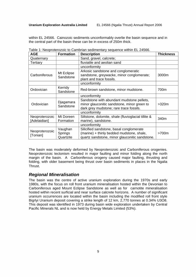
Regional Geology The Ngalia Basin is a large 300 km by 70 km east-west elongate intracratonic basin covering an area of 15,000km2 within central Northern Territory. The Basin consists of approximately 6000m of Palaeozoic and Neoproterozoic sediments, which are thickest near the northern margin of the basin. The sequence consists of Neoproterozoic to Ordovician shallow marine and fluvial to glacial clastic, carbonate and evaporitic rocks. These are overlain by Carboniferous fluvial to continental sandstone, greywacke and siltstone. These units overlying are derived from Palaeoproterozoic to Mesoproterozoic metamorphic rocks and granites (Yarunganyi Granite, 1567 ± 11 Ma, SHRIMP, Young et al.1995) of the Arunta Block (Figure 1). The Proterozoic sedimentary rocks include the Vaughan Springs Quartzite, the Mt. Doreen Formation and the Yuendumu Sandstone. These are overlain by the Cambrian Walbiri Dolomite and the Bloodwood Formation followed by the Ordovician Djagamara Formation and Kerridy Sandstone and the Carboniferous Mt. Eclipse Sandstone. The table below summarises the Neoproterozoic to Cambrian sedimentary sequence located
Uranium Exploration Australia Limited EL 24566 (Ngalia Thrust) Annual Report 2006
9
within EL 24566. Cainozoic sediments unconformably overlie the basin sequence and in the central part of the basin these can be in excess of 250m thick. Table 1: Neoproterozoic to Cambrian sedimentary sequence within EL 24566. AGE Formation Description Thickness Quaternary Sand, gravel, calcrete; Tertiary fluviatile and aeolian sand unconformity
Carboniferous Mt Eclipse Sandstone
Arkosic sandstone and conglomeratic sandstone, greywacke, minor conglomerate; plant and trace fossils.
3000m
unconformity
Ordovician Kerridy Sandstone Red-brown sandstone, minor mudstone. 700m
unconformity
Ordovician Djagamara Sandstone
Sandstone with abundant mudstone pellets, minor glauconitic sandstone, minor green to dark grey mudstone; rare trace fossils.
>320m
unconformity Neoproterozoic [Adelaidian]
Mt Doreen Formation
Siltstone, dolomite, shale (fluvioglacial tillite & marine), sandstone. 340m
unconformity
Neoproterozoic [Tonian]
Vaughan Springs Quartzite
Silicified sandstone, basal conglomerate (marine) + thinly bedded mudstone, shale, quartz sandstone, minor glauconitic sandstone.
>700m
The basin was moderately deformed by Neoproterozoic and Carboniferous orogenies. Neoproterozoic tectonism resulted in major faulting and minor folding along the north margin of the basin. A Carboniferous orogeny caused major faulting, thrusting and folding, with older basement being thrust over basin sediments in places in the Ngalia Thrust.
Regional Mineralisation The basin was the centre of active uranium exploration during the 1970s and early 1980s, with the focus on roll front uranium mineralisation hosted within the Devonian to Carboniferous aged Mount Eclipse Sandstone as well as for carnotite mineralisation hosted within recent surficial and near surface calcrete horizons. A number of significant uranium occurrences are located within the basin including the modified roll front style Bigrlyi Uranium deposit covering a strike length of 12 km, 2,770 tonnes at 0.34% U3O8. This deposit was identified in 1973 during basin wide exploration undertaken by Central Pacific Minerals NL and is now held by Energy Metals Limited (53%).

Uranium Exploration Australia Limited EL 24566 (Ngalia Thrust) Annual Report 2006
10
Surface Geochemistry A reconnaissance field trip was conducted over EL 24566 during the first quarter of 2006. During this reconnaissance UXA undertook a two phase spectrometric - geochemistry prospecting approach to evaluate sites selected from available gravity and airborne magnetic and radiometric data as outlined below.
Field Sampling Procedures Selected sites were “ground truthed” using hand held scintillometers giving a total count (TC) reading during traverses of the sites to ascertain the extent of the anomaly. Three spot readings were taken at each stop which was twice (x2) background, giving a maximum, a minimum and a median TC value. Once the sites area extent had been determined a 300 gram sample of the material at surface was collected. The sample type recorded and the local geomorphology and geology described. The material collected from EL 3428 is described as Tertiary – Recent sand dune. This sample was later subject to a spectrometer reading to determine the radioactive TC of the sample and the component U, Th and K radioactivity levels. This was recorded with the sample information.
Analytical Procedures The samples were sent to the laboratory for chemical assay analysis. On consultation with previous workers in the region, UXA had the samples analysed for first pass indicator elements of U, Ag, Pb, Cu, Co, Fe, Mn, and Zn by ICP-MS mass spectrometer chemical assay techniques. Genalysis Laboratory Services Pty Ltd of Perth were used for the chemical analysis work using their standard sample preparation and analysis techniques for the sample types submitted and the elements required. Below is a list of the elements analysed, the corresponding technique used and the limit of detection of that technique. ELEMENTS Ag Co Cu Fe Mn Pb U Zn Au
UNITS ppm ppm ppm % ppm ppm ppm ppm ppb DETECTION 0.01 0.1 1 0.01 1 1 0.01 1 10
METHOD B/MS B/MS B/OES B/OES B/OES B/MS B/MS B/OES SAAS Appendix 1 lists further information on the methods and sample preparation by Genalysis.

Uranium Exploration Australia Limited EL 24566 (Ngalia Thrust) Annual Report 2006
11
Assay Results A total of nine rock chip samples were collected (Figure 3), described (Table 2) and subject to spectrometer discrimination of uranium, potassium and thorium (Table 3).
Figure 3: Sample location map. Table 2: Description of samples.
Sample Number Comment
1 Granitic outcrop with muscovite alteration - greissenisation. NS + EW fracturing, this outcrop was very granular.
2 Another granite outcrop, with no visible greissenisation and far less granular. 3 Boundary between quartz reef and granite. The quartz vein was 20m thick
trending NW, steeply dipping towards NE. Veins of iron (Fe) and possible secondary U mineralisation occur in 5-25mm bands. Manganese and iron spotting on the surface are common throughout the outcrop.
3b As above 4 Massive outcrop of granite. This granite has massive feldspar phenocrysts, up
to 7cm long. Fairly homogeneous. Isolated occurrences of muscovite and biotite rich rock.
5 Massive granite outcrop. Feldspar rich, with gossonous parts. Manganese and muscovite rich zones give the highest scintillometer readings. E-W alignment of outcrop.
6 Very weathered and leached granite sub-crop.

Uranium Exploration Australia Limited EL 24566 (Ngalia Thrust) Annual Report 2006
12
Table 3: Uranium, potassium, thorium spectrometer discrimination on samples Spectrometer Sample Number Easting Northing
Scintillometer count/minute Total K U Th
eUppm % eUppm eUppm 1 740081.9 7532790.227 750 11.3 0 6.8 11 2 742467.8 7533368.677 242 9.4 0.4 5.9 0.3 3 744422.5 7533830.466 1187 20.8 1 9.7 21
3b 744422.5 7533830.466 813 22.1 1.7 13 12 4 745745.4 7534178.915 822 13.1 0 14 0 5 746119.6 7534296.098 661 11.5 0.8 4.1 2.2 6 753351.4 7536919.075 180 9.2 0.3 7.4 2.1 7 762911.1 7543193.22 300 12.4 0.5 11 0 8 751143.9 7549295.508 1240 9.4 0 7.5 4.7
The samples were submitted to Genalysis Laboratory Services in Maddington, Western Australia, and analysed by spectrometry for gold, silver, copper, iron, manganese, lead, uranium and zinc as per Genalysis Laboratory Services sample preparation and analysis method (Appendix 1). The results for the nine samples are listed below in Table 4.
Table 4: Analytical results for rock chip samples ELEMENTS Au Ag Cu Fe Mn Pb U Zn UNITS ppm ppm ppm % ppm ppm ppm ppm DETECTION 0.01 0.01 1 0.01 1 1 0.01 1 METHOD B/SAAS B/MS B/OES B/OES B/OES B/MS B/MS B/OES Sample Number Ngalia 1 X 0.05 17 0.59 87 103 11.82 39 Ngalia 2 X X 14 0.51 108 4 1.13 5 Ngalia 3 X X 3 0.4 43 13 10.31 10 Ngalia 3b X 0.01 4 0.47 86 14 1.07 5 Ngalia 4 X X 3 1.82 348 17 25.17 44 Ngalia 5 X X 3 1.76 445 15 10.29 38 Ngalia 6 X X 12 2.46 100 8 0.89 30 Ngalia 7 X X 5 6.37 817 6 2.68 79 Ngalia 8 X 0.01 5 2.5 255 17 4.11 34 CHECKS Ngalia 1 X 0.04 18 0.64 92 113 12.96 39 STANDARDS AMIS0004 0.38 0.46 106 3.13 498 93 73.75 214 BLANKS Control Blank X 0.01 X X X X X X Control Blank X 0.01 X X X X 0.03 X X denotes below detection
7 Tenement northwest bounds on the Tanami Rd. Roadside sub-crop of muscovite-biotite schist.
8 Roadside massive outcrop of granite. Some zones nearly pegmatitic, with potential secondary U mineralisation along fractures.
Uranium Exploration Australia Limited EL 24566 (Ngalia Thrust) Annual Report 2006
13
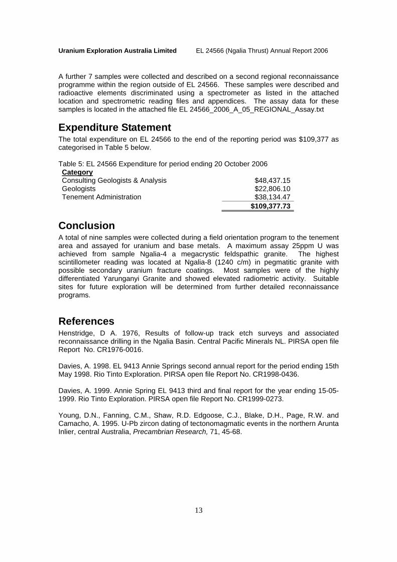
A further 7 samples were collected and described on a second regional reconnaissance programme within the region outside of EL 24566. These samples were described and radioactive elements discriminated using a spectrometer as listed in the attached location and spectrometric reading files and appendices. The assay data for these samples is located in the attached file EL 24566_2006_A_05_REGIONAL_Assay.txt
Expenditure Statement The total expenditure on EL 24566 to the end of the reporting period was $109,377 as categorised in Table 5 below. Table 5: EL 24566 Expenditure for period ending 20 October 2006 Category Consulting Geologists & Analysis $48,437.15 Geologists $22,806.10 Tenement Administration $38,134.47 $109,377.73
Conclusion A total of nine samples were collected during a field orientation program to the tenement area and assayed for uranium and base metals. A maximum assay 25ppm U was achieved from sample Ngalia-4 a megacrystic feldspathic granite. The highest scintillometer reading was located at Ngalia-8 (1240 c/m) in pegmatitic granite with possible secondary uranium fracture coatings. Most samples were of the highly differentiated Yarunganyi Granite and showed elevated radiometric activity. Suitable sites for future exploration will be determined from further detailed reconnaissance programs.
References Henstridge, D A. 1976, Results of follow-up track etch surveys and associated reconnaissance drilling in the Ngalia Basin. Central Pacific Minerals NL. PIRSA open file Report No. CR1976-0016. Davies, A. 1998. EL 9413 Annie Springs second annual report for the period ending 15th May 1998. Rio Tinto Exploration. PIRSA open file Report No. CR1998-0436. Davies, A. 1999. Annie Spring EL 9413 third and final report for the year ending 15-05-1999. Rio Tinto Exploration. PIRSA open file Report No. CR1999-0273. Young, D.N., Fanning, C.M., Shaw, R.D. Edgoose, C.J., Blake, D.H., Page, R.W. and Camacho, A. 1995. U-Pb zircon dating of tectonomagmatic events in the northern Arunta Inlier, central Australia, Precambrian Research, 71, 45-68.

Uranium Exploration Australia Limited EL 24566 (Ngalia Thrust) Annual Report 2006
i
Appendix 1: Genalysis Sample Preparation and Assay Methods
The Preparation of Mineral Exploration Samples In recent times there has been a trend in the exploration industry to want to take larger and larger samples in the field, with the aim of then preparing the total sample collected. However, pulverisers that are currently available commercially are limited in their effective capacity, and this does place some restrictions on what can be achieved cost-effectively.
The standard sample preparation procedure at Genalysis is: Single Stage Mix and Grind (SSMG) (limited to samples not exceeding 3kg) General Description Dry total sample, (jaw crush if necessary); single stage mix and grind total sample in an appropriately sized pulveriser (ring mill or puck type). Optional barren quartz clean of bowl between samples. Approximately 200g (or more, depending on the analytical requirements) is packaged in a paper sample envelope as the laboratory portion. The balance of the bulk pulp is stored in a new plastic bag.
Pulveriser bowls of “removable” configuration are available in 50g, 100g, 300g and 750g capacities. The typical maximum capacity of “fixed” configuration is 3kg.
Samples up to 750g For samples up to 750g, the grinding efficiencies are such that particle size of the product is not normally an issue. Grinding times are relatively short (1 to 2 minutes).
Samples greater than 750g up to 3kg For the 3kg capacity mills the grinding time is set at four minutes. Test work has shown that particle size distribution may not be improved by grinding for longer than four minutes. Whilst the aim is to produce a bulk pulp of nominally 90% minus 75 micron, this may not be achievable with certain very hard samples. If fine grind is considered essential, please discuss sample preparation options with Genalysis management prior to commencement of any project.
Disc Mills Genalysis does not use disc mills either vertically mounted (Braun and Bico) or horizontally mounted (Keegor). Reasons (a) May exacerbate coarse Gold problems. (b) May produce platelets of sample that are "fine" in one plane only. (c) Notorious sample segregators, particularly for samples containing a mixture of
minerals of varying hardness or density. REMEMBER: The assay can only be as good as the sample preparation. www.genalysis.com.au Sample Prepv2-0.doc

Uranium Exploration Australia Limited EL 24566 (Ngalia Thrust) Annual Report 2006
ii
Analysis of Mineral Exploration Samples for Gold
Routine Exploration and Ore Reserve Samples Two basic options are available for Gold - aqua regia or fire assay. 1) Aqua Regia
Aqua Regisa digest (10, 25 or 50g charge), solvent extraction, flame AAS finish to 0.01 ppm LLD.
Advantages
a) Generally more accurate at the lower level (i.e. less than 0.2ppm) - hence best method for RAB composites and sterilisation samples.
b) Many other elements can be analysed at the same time using an aliquot of the 10g digest for little incremental cost.
c) Cheaper than Fire Assay.
Other elements available: - Figures in brackets are detection limits [ppm, except where stated] for
1. by flame AAS: Ag(0.1) As(10) Bi(2) Ca(0.1%) Cd(0.1) Co(1) Cr(1) Cu(1) Fe(0.01%) Mg(0.1%) Mn(1) Mo(2) Ni(1) Pb(1) Sb(2) Te(2) Ti(2) Zn(1)
2. by ICP-OES:
Ag(0.5) Al(20) As(2) Ba(2) Bi(10) Ca(0.01%) Cd(0.5) Co(1) Cr(2) Cu(1) Fe(0.01%) K(20) Mg(0.01%) Mn(1) Mo(2) Ni(1) P(20) Pb(2) S(10) Sb(10) Sc(1) Te(5) V(2) Zn(1)
3. by enhanced sensitivity ICP-OES: Ag(0.1) Bi(1) Cd(0.1) Mo(1) Pb(1) Sb(1) Te(1) Tl(1)
4. by ICP-MS: Ag(0.01) As(0.5) Au(1ppb) Ba(1) Be(0.05) Bi(0.01) Cd(0.05) Ce(0.01) Co(0.1) Cs(0.002) Dy(0.01) Er(0.01) Eu(0.01) Ga(0.05) Gd(0.01) Ge(0.05) Hf(0.01) Ho(0.01) In(0.01) Ir(5ppb) La(0.01) Li(0.1) Mo(0.1) Nb(0.02) Nd(0.01) Pb(1) Pd(10ppb) Pr(0.005) Pt(5ppb) Rb(0.02) Re(0.01) Rh(10ppb) Ru(10ppb) Sb(0.02) Sc(1) Se(1) Sm(0.01) Sn(0.05) Sr(0.02) Ta(0.01) Tb(0.005) Te(0.05) Th(0.01) Tl(0.01) Tm(0.01) U(0.01) W(0.05) Y(0.02) Yb(0.01) Zr(0.1)
Considerations (a) Gold associated with graphitic shales may not be dissolved - requires pre-roast or fire
assay.
(b) Massive sulfides difficult to completely digest - use pre-roast or fire assay.

Uranium Exploration Australia Limited EL 24566 (Ngalia Thrust) Annual Report 2006
iii
(c) Gold associated with, or encapsulated in, acid insoluble minerals may not be dissolved (e.g. Silicates, Barite, Chromite, Tantalite) - use fire assay.
(d) Some of the analytes may only be partially extracted, depending on mineral type.
2) Fire Assay Lead Collection Fire Assay (25g or 50g charge), flame AAS finish to 0.01 ppm LLD. Advantage
(a) Good for almost all mineral types.
Considerations (a) More expensive than Aqua Regia.
(b) Highly mineralized samples (e.g. Cu >5%. Ni >2%, Cr >5%, S >5%) require specific fluxes, and/or reduction in sample weight significantly below the nominal charge, for correct fusion and quantitative recovery of Gold. Very experienced assayers required when analysing a variety of sample types.
(c) To avoid problems of disposal of large volumes of pots, generally pots are recycled. The use of recycled pots creates a potential problem of carry-over from previous sample in that pot (approximately 2 - 5% but not consistent). Genalysis discards any pot where the sample was greater than 5g/t. Use of new pots once only adds to cost.
(d) Other elements require separate digest.
(e) Health risks for operators and new industry amendments will increase lead monitoring in blood (at company’s cost).
(f) Produces waste products containing Lead - ever increasing restrictions and higher costs of disposal. Lead collection fire assay likely to become very expensive in the future.
www.genalysis.com.au PPMV5-0.DOC

Uranium Exploration Australia Limited EL 24566 (Ngalia Thrust) Annual Report 2006
iv
Appendix 2: Rock sample locations and descriptions NGALIA EL 24566 NORTH ARUNTA BLOCK, NORTHERN TERRITORY.
GPS Eastings Northings Sample No COMMENTS S(22deg) E(131deg)
740081.9 7532790 Ngalia 1
Outside tenement, granitic outcrop, greinisation, with muscovite alteration. N/S E/W fracturing, this outcrop was very granular
17.603' 19.819'
742467.8 7533369 Ngalia 2Another granite outcrop, with no visible greinisation and far less granular
17.297' 21.194'
744422.5 7533830 Ngalia 3
Boundary btw quartz reef and granite. The quartz vein was 20m thick trending N/W, steeply dipping NE. Veins of Fe and possible secondary U mineralisation occur in 5-25mm bands. Commonly throughout are Mn and Fe spotting on the surface.
17.031' 22.335' 744422.5 7533830 Ngalia3b as for Ngalia 3 17.031' 22.335'
745745.4 7534179 Ngalia 4
Massive outcrop of granite. This granite has massive feldspar phenocrysts, up to 7cm long. Fairly homogeneous. Isolated occurrences muscovite and biotite rich rock.
16.829' 23.101'
746119.6 7534296 Ngalia 5
Massive granite outcrop. Feldspar rich, with gossonous bits. Mn and muscovite rich zones kicking the highest. E-W alignment of outcrop.
16.762' 23.314'
753351.4 7536919 Ngalia 6Very weathered and leached granite subcrop.
15.290' 27.492'
762911.1 7543193 Ngalia 7
Outside tenement, northwest bound on the Tanami rd. Roadside subcrop, muscovite-biotite schist.
11.801' 33.001'
751143.9 7549296 Ngalia 8
Outside tenement. Roadside massive outcrop of granite. Some zones nearly pegmatitic, with potential secondary U mineralisation along fractures.
08.598' 26.099' 16.742' 22.004' NGL1 Granite quartz reef contact

Uranium Exploration Australia Limited EL 24566 (Ngalia Thrust) Annual Report 2006
v
16.634' 21.931' NGL2 As above 12.880' 35.472' NGL3 Roadside
14.030' 39.118' NGL4
Roadside. Off the Tanami Rd, calcareous sediment with qtz veining, the rock appears quite granitic and may be altered granite with the release of ca through thermal alteration or weathering. Additional bi-mu schist is scattered along the side of the road. NB. This is not in tenement.
16.061' 25.896' NGL5
Scrape site with exposure of meta-sediments associated with intrusion of the proximal granites. The unit is trending NW.
19.217' 18.427' RR1
Rankins reward prospect, a small u rich sandstone amongst the 20yr old ruins. The same site has fossilised wood within sandstone.
19.217' 18.427' FOSSILSED WOOD
Rankins reward prospect, a small u rich sandstone amongst the 20yr old ruins. The same site has fossilised wood within sandstone.

Uranium Exploration Australia Limited EL 24566 (Ngalia Thrust) Annual Report 2006
vi
Appendix 3: Rock sample scintillometer and spectrometer readings NGALIA EL NORTH ARUNTA BLOCK, NORTHERN TERRITORY. SPECTROMTER SAMPLE NO SCINT0 C/M Total K U Th
e.ppm % e.ppm e.ppm Ngalia 1 750 11.3 0 6.8 11.2 Ngalia 2 242 9.4 0.4 5.9 0.3 Ngalia 3 1187 19.3 1.8 0 40.5
Ngalia3b 813 22.1 1.7 13 12.1 Ngalia 4 822 13.1 0 14.3 0 Ngalia 5 661 11.5 0.8 4.1 2.2 Ngalia 6 180 9.2 0.3 7.4 2.1 Ngalia 7 300 12.4 0.5 10.7 0 Ngalia 8 1240 9.4 0 7.5 4.7 NGL1 870 5.2 0.6 2 0 NGL2 780 4.7 0 3.5 0 NGL3 760 4.3 0.2 2.4 0 NGL4 360 4.8 0.1 2.2 0 NGL5 220 4 0 4 0 RR1 1300 98.9 1.8 133.2 0 FOSSILSED WOOD 4.3 0 2.1 0
Uranium Exploration Australia Limited EL 24566 (Ngalia Thrust) Annual Report 2006
vii
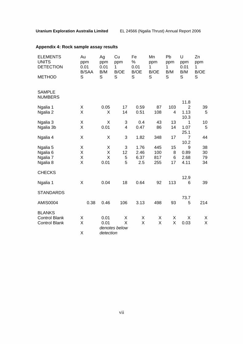
Appendix 4: Rock sample assay results ELEMENTS Au Ag Cu Fe Mn Pb U Zn UNITS ppm ppm ppm % ppm ppm ppm ppm DETECTION 0.01 0.01 1 0.01 1 1 0.01 1
METHOD B/SAAS
B/MS
B/OES
B/OES
B/OES
B/MS
B/MS
B/OES
SAMPLE NUMBERS
Ngalia 1 X 0.05 17 0.59 87 103 11.8
2 39Ngalia 2 X X 14 0.51 108 4 1.13 5
Ngalia 3 X X 3 0.4 43 13 10.3
1 10Ngalia 3b X 0.01 4 0.47 86 14 1.07 5
Ngalia 4 X X 3 1.82 348 17 25.1
7 44
Ngalia 5 X X 3 1.76 445 15 10.2
9 38Ngalia 6 X X 12 2.46 100 8 0.89 30Ngalia 7 X X 5 6.37 817 6 2.68 79Ngalia 8 X 0.01 5 2.5 255 17 4.11 34 CHECKS
Ngalia 1 X 0.04 18 0.64 92 113 12.9
6 39 STANDARDS
AMIS0004 0.38 0.46 106 3.13 498 93 73.7
5 214 BLANKS Control Blank X 0.01 X X X X X XControl Blank X 0.01 X X X X 0.03 X
X denotes below detection