uranium in black shale deposits, northern rocky mountains and
TRANSCRIPT
Uranium in Black Shale Deposits, Northern Rocky Mountains and Great Plains
GEOLOGICAL SURVEY BULLETIN 1030-H
This report concerns work done on behalf of the U. S. Atomic Energy Commission and is published with the permission of the Commission
Uranium in Black Shale Deposits, Northern Rocky Mountains and Great PlainsBy W. J. MAPEL
CONTRIBUTIONS TO THE GEOLOGY OF URANIUM
GEOLOGICAL SURVEY BULLETIN 1030-H
This report concerns work done on behalf of the U. S. Atomic Energy Commission and is published with the permission of the Commission
UNITED STATES GOVERNMENT PRINTING OFFICE, WASHINGTON : 1956
UNITED STATES DEPARTMENT OF THE INTERIOR
Fred A. Seaton, Secretary
GEOLOGICAL SURVEY
Thomas B. Nolan, Director
For sale by the Superintendent of Documents, U. S. Government Printing Office Washington 25, D. C. - Price 55 cents (paper cover)
CONTENTS
PageAbstract_________________.______________________ 211Introduction._____________________________________________________ 211
Purpose and location_________________________________________ 211Acknowledgments.-____ _____________________________________ 213
Field work and use and interpretation of the gamma-ray logs._________ 213Summary of the results of the investigation._________________________ 215Descriptions of selected black shale deposits._________________________ 219
Black shale at the base of the Madison limestone and equivalents. _ _ 219Black shale at the base of the Brazer limestone....________________ 230Heath shale__________________________________ 230
Literature cited___________________________________________________ 233Index. ___._____-_-_-____________________._______ 235
ILLUSTKATIONS
[Plates 14 and 15 in pocket.]
PL.AT.E 14. Index map showing black shale localities examined for ura nium, northern Rocky Mountains and Great Plains.
15. Map and sections showing thickness and radioactivity of the Bakken formation (as used by Kordquist, 1953), northern Great Plains. Page
FIGURE 51. Locations of selected wells for which gamma-ray logs werestudied____________________________________________ 214
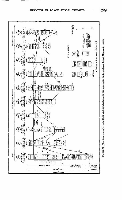
52. Sections showing uranium content of basal black shale of Mississippian age at outcrops in the northern Rocky Mountains region.__________________________________ 229
53. Sections showing uranium content of black shale at the base ofthe Brazer limestone, Utah and Idaho __________________ 231
54. Thickness and distribution of the Heath shale in central Montana and the Heath shale and Otter formation in eastern Montana and adjacent parts of North and South Dakota.______________________________ 232
TABLES
Page
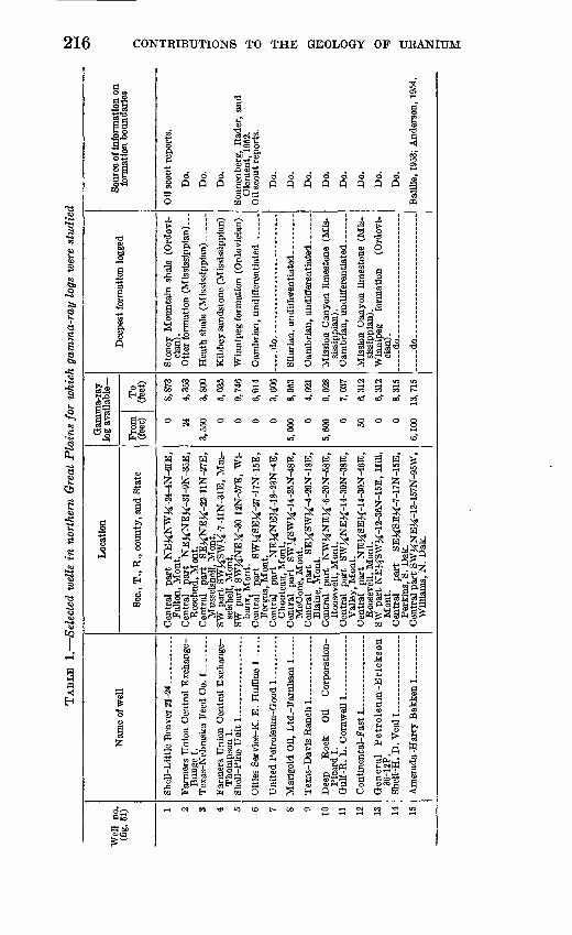
TABLE 1. Selected wells in northern Great Plains for which gamma-raylogs were studied_____-_-_-_____-_---_-_____-___-------- 216
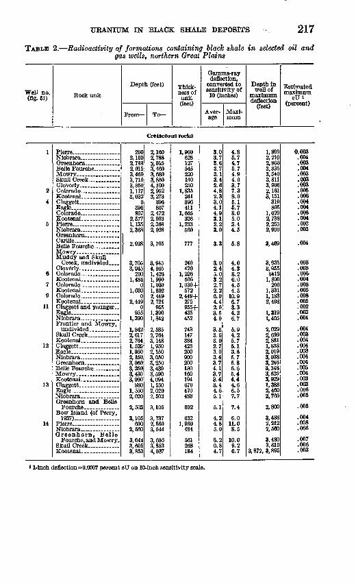
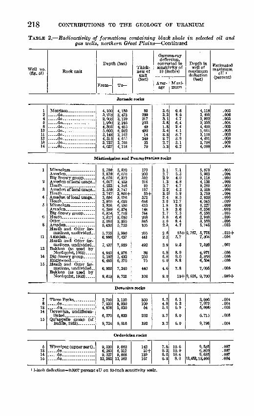
2. Radioactivity of formations containing black shale in selectedoil and gas wells, northern Great Plains.__________________ 217
3. Analytical data and outcrops examined.____________________ 220
m

CONTRIBUTIONS TO THE GEOLOGY OF URANIUM
URANIUM IN BLACK SHALE DEPOSITS, NORTHERN ROCKY MOUNTAINS AND GREAT PLAINS
By W. J. MAPEL
ABSTRACT
Reconnaissance examinations for uranium in 22 formations containing black shale were made in parts of Montana, North Dakota, Utah, Idaho, and Oregon in 1953. About 150 samples from 80 outcrop localities and 5 oil and gas wells were submitted for uranium determinations. Most of the black shale deposits examined contain less than 0.003 percent of uranium; however, thin beds of black shale at the base of the Mississippian system contain 0.005 percent of uranium at 2 outcrop localities in southwestern Montana and as much as 0.007 percent of uranium in a well in northeastern Montana. An 8-foot bed of phosphatic black shale at the base of the Brazer limestone of middle and late Mississippian age in Rich County, Utah, contains as much as 0.009 percent of uranium.
Commercial gamma-ray logs of oil and gas wells drilled in Montana and adjacent parts of the Dakotas indicate that locally the Heath shale of late Mississippian age contains as much as 0.01 percent of equivalent uranium, and black shales of Late Cretaceous age contain as much as 0.008 percent of equivalent uranium.
INTRODUCTION
PURPOSE AND LOCATION
A reconnaissance search for uranium in black shale in the northern Rocky Mountains and Great Plains regions was carried out during the summer of 1953 by the U. S. Geological Survey on behalf of the Division of Raw Materials, U. S. Atomic Energy Commission. The work is part of a continuing program to investigate the uranium possibility of untested or incompletely tested black shale deposits* in the Western States. Most of the localities visited are in southwestern and central Montana, central and southeastern Idaho, and north western Utah. About 150 gamma-ray logs from wells drilled for oil and gas in Montana and adjacent parts of North and South
211
212 CONTRIBUTIONS TO THE GEOLOGY OF URANIUM
"53 <a S'
nd so Mont
Ce w
-I"
II »a2'So
i i °
-
Pw >.
ccKoM g 'ac
S0 fl d 53fi 50
le le
S G
o si 'o o
URANIUM IN BLACK SHALE DEPOSITS 213
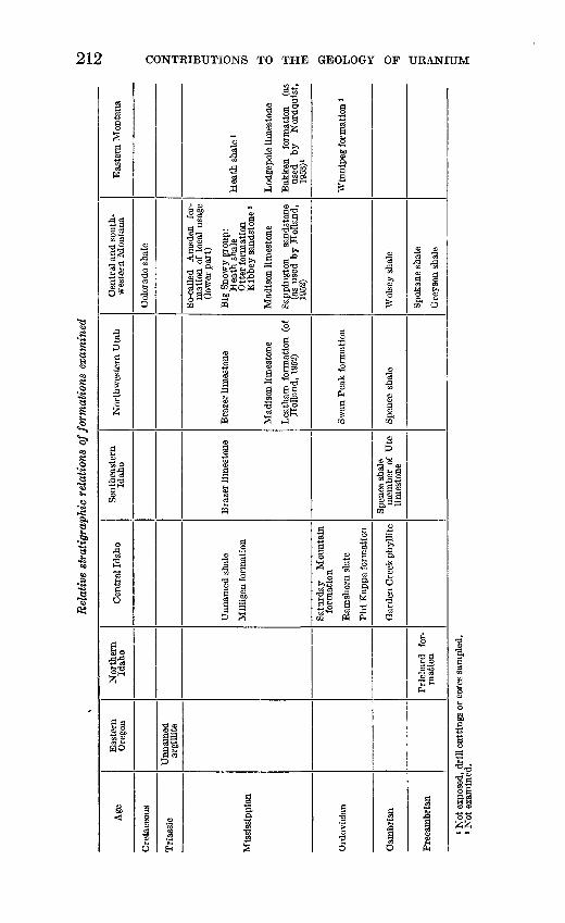
Dakota were scanned for anomalous radioactivity, and samples of drill cores or cuttings from 5 of the wells were submitted for uranium determinations. Plate 14, the index map, shows the localities visited, and the table above shows the formations examined.
Previous work by Duncan (1953) indicated that the Heath shale of late Mississippian age and a thin black shale sequence of early Missis- sippian age called variously the Bakken formation (as used by Nordquist, 1953), the shale of Kinderhook age, or the Exshaw forma tion (Warren, 1937) at some places contain abnormally large amounts of uranium. Particular attention was given to a systematic sampling of these formations in an attempt to define areas of maximum or minimum radioactivity which might then be related to facies changes, source areas, thickness, or other factors that reflect environments of deposition.
Black shale of the Phosphoria formation of Permian age is known to contain uranium in the northern Kocky Mountains region, but it was excluded from the study because it has been sampled extensively as part of a separate investigation by the Geological Survey.
ACKNOWLEDGMENTS
The present investigation is a continuation of previous reconnais sance studies made at various times since 1951 in the Rocky Moun tains region, as reported by Duncan (1953).
D. C. Duncan, R. J. Ross, J. E. Smedley, R. P. Kunkel, P. W, Richards, and H. D. Hadley supplied samples of black shale or guided the writer to exposures of shale in Utah and Montana. W. J. Hail, Jr., compiled information from the gamma-ray logs and assisted in interpreting the results of this work. Radiometric and chemical analyses listed in this report were made in Geological Survey laboratories.
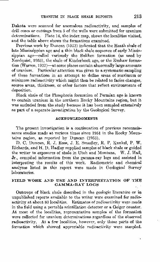
FIELD WORK AND USE AND INTERPRETATION OF THE GAMMA-RAY LOGS
Outcrops of black shale described in the geologic literature or in unpublished reports available to the writer were examined for radio activity at about 80 localities. Estimates of radioactivity were made in the field using a portable scintillation detector or a Geiger counter;. At most of the localities, representative samples of the formation were collected for uranium determinations regardless of the observed radioactivity. At a few localities, however, only those parts of the formation which showed appreciable radioactivity were sampled.

214 CONTRIBUTIONS TO THE GEOLOGY OF URANIUM
Roads between outcrops were traversed with a car-mounted scintilla tion counter, and those areas with higher than average background were examined on foot with the portable instruments.
The examination of gamma-ray logs of wells drilled for oil or gas provides a convenient means of evaluating the uranium possibilities of many black shale formations which otherwise might be difficult to test because of poor natural exposures or broad outcrop areas. Gott and Hill (1953), in a study of commercial gamma-ray logs of uncased wells drilled in the Rangely field, northeastern Utah, found that, on the average, a 1-inch deflection of the Lane Wells gamma-ray curve at a 10-inch sensitivity scale is caused by about 0.0007 percent of equiv alent uranium. They pointed out that variations hi this value might be caused by such factors as the ratio of thickness to grade of the bed tested, the fluid content of the well, the shielding effect of casing in cased wells, differences in individual logging instruments, and the rate of movement of the ionization chamber. The calibration, there fore, is only approximate, but it gives some measure of the order of magnitude of radioactivity of the formations penetrated, and it is useful in comparing the radioactivity of the rocks from place to place.
Tables 1 and 2 list 15 wells drilled hi Montana and the Dakotas and indicate the average and maximum deflections on the gamma-ray logs of formations containing significant amounts of black shale. The locations of these wells are given in figure 51. Gamma-ray logs of
c A N A D A- ..__. . . - ~y
.6.9 »li V2 1Q4
^ ^ "" ! NORTHDA KOTA
MO N- "* T A A-» ... ^ )N _ . , £.5
-» S"***" "^"j Y""""" x | SOUTH ^ f .. ..__- - ~j DAKOTA
0 ^ -JN W Y O M ING
FIGTTEE 51. Locations of selected wells for which gamma-ray logs were studied (table 1).
URANIUM IN BLACK SHALE DEPOSITS 215
other wells examined but not listed in tables 1 and 2 show comparable radioactivity values.
SUMMARY OF THE RESULTS OF THE INVESTIGATION
Uraniferous deposits of black shale thus far found in the northern Rocky Mountains and Great Plains regions are either deeply buried and inaccessible, or they are too thin or of too low grade to be of value at this time as a source for uranium. Only a few of the deposits contain more than 0.003 percent of uranium. Of these few, beds of black shale at the base of the Madison limestone of early Mississippian age contain 0.005 to 0.007 percent of uranium at three localities in Montana and one in North Dakota (Iocs. 43, 44, 82, and 85, pi. 14), and 4 feet of a bed of black shale 8 feet thick at the base of the Brazer limestone of middle and late Mississippian age contains 0.009 percent of uranium at one locality in Rich County, Utah (loc. 30). The analyses of samples collected at these and other localities are listed in table 3.
The evaluation of gamma-ray logs of oil and gas wells, as shown by table 2, suggests that the Heath shale of late Mississippian age locally contains 0.009 percent of equivalent uranium or more in Musselshell and McCone Counties, Mont., and that the Colorado and Pierre shales of Cretaceous age contain as much as 0.008 percent of equivalent uranium in Blaine County, Mont., and in Perkins County, S. Dak., respectively. No drill cores or cuttings from these wells were avail able for analyses, and so the actual uranium content of the shale is unknown.
216 CONTRIBUTIONS TO THE GEOLOGY OF URANIUM
s § ooong5oooooooo,,r M Q Q P §§§QQfiQfiQflQS
1
8 "^ e
5; e
a iJ3 O-a "Sai§ s
*jo a
.2 a § a g g a 22 !§ a SO »^H M » *
fp 13 p T)
a ^ 3/^*
a *5Q D
!I1 I
>> .0
§ ! "g
D a BO
C>» 0» US US*-( *-l »-H r~*CO CO CO t~
^ O O O O O O O O
us us
-2
8 S 1 1
S-a-g-a 1 s| a M~a l-ag-ao «I^ g'a^'a | a-g-al-a^s h g «3_g eyg a|ii feis.gis'Shlii 2^5^ 8 a.o^'S^ajSgSgggrtg^gtf^SgSI^
D5QEQDDDDOOD5QDD
S ^« * "H o a O
P og flW .2
^§-"3:sgf
3 13W gH 9i I
s e^i ?y ^ 2g£!? 8 SSs|S
PH e
H ° I a)Bas «M^J o> 73to w D
rt< «C CO
fl -3§ O g85 g
P? §a -8 o> o , 85 Q3 1~I M
p -a*$E? §POO
_ O)
i 1 i5 £ ^-2 p' 1 28iw'
®Vri,
§^1
OO O5 O i-l
URANIUM IN BLACK SHALE DEPOSITS 217
TABLE 2. Radioactivity of formations containing black shale in selected oil and gas wells, northern Great Plains
Well no. (fig. 51) Rock unit
Depth (feet)
From To
Thick ness of unit (feet)
Gamma-raydefle Jtion.
converted to sensitivity of
10 (inches)
Average
Maxi-
Depth in well of
maximum deflection
(feet)
Estimated maximum
eTJi (percent)
Cretaceous rocks
1
2
4
5
6
7
9
11
12
13
14
Pierre _______
Greenhorn ______Belle Fourche ..........
Skull Creek............Cloverly ...............Colorado _______KootenaL. ............Claggett . ...........EagleColorado _______KootenaL- ............Pierre . ..............Niobrara _______Greenhorn .............Carlile .Belle Fourche .......Mowry ._.._.__...._...Muddy and Skull
Creek, undivided .... Cloverly ...............Colorado _______
Colorado ..........Kootenal ..............Colorado _______Kootenai ..............Claggett and younger. . Eagle _________Niobrara _ . ___ , ....Frontier and Mowry,
undivided.. .........Skull Creek....... .....Kootenai _ ...........Claggett.-.. ...........Eagle -.........-.-.-...
Greenhorn .............Belle Fourche ____ .
Kootenai ..............
Eagle.- ________
Greenhorn and Belle Fourche .............
Bow Island (of Perry, 1937).................
Greenhorn, Belle Fourche, and Mowry.
Skull Creek .........
2002,1602,7882,9153,4603,7103,8501,1173,032
0396807
2,5771,1352,368
| 2,928I
3,705 3,945
2001,484
01,030
02,449
0 955
1,390
1,8422,6172,7641,5251,9502,1503,0503,2503,4303,900
8801,5502,020
2,503
3,105600
2,560
3,044 3,6053,853
2,1602,7882,9153,4603,6803,8504,1002,9523,273
396807
2,4722,9032,3682,928
3,705
3,945 4,3651,4261,9901,0301,6022,4492,724
955 1,3901,842
2,5852,7643,1481,9502,1503,0503,2503,4303,5904,0941,5502,0202,503
3,105
3,7372, 5603 044
3,605 3,8534,037
1,960628127545220140250
1,835241396411
1,665326
1,233560
777
240 420
1,226506
1,030+572
2,449+275955+ 435452
743147384425200900200180160194670470483
602
6321,960
484
561248184
3.03.73.63.73.13.42.64.82.33.04.14.93.12.23.0
3.3
3.0 2.45.03.22.72.26.04.42.0 3.54.0
3.33.53.02.73.03.43.74.13.73.43.44.65.1
5.1
4.24.85.0
6.20.84.7
4.85.74.75.74.94.03.77.38.05.15.78.05.03.44.5
5.8
4.0 4.38.26.04.54.5
10.96.73.3 4.26.7
5.94.25.76.13.65.75.86.65.44.44.66.57.7
7.4
6.011.08.5
10.0 9.26.7
1,8992,2102,8603,3353,5403,8113,9082,1613,151
319805
1,6292,7382,2552,900
3,469
3,935 3,9556412
1,890200
1,3311,1832,498
1,3191,405
2,0292,6992,8811,8582,0193,0383,2463,3483,5253,9291,3882,4602,760
2,800
3,4882,2122,560
3,480 3,610
3,872,3,895
0.003.004.003.004.003.003.003.005.006.004.004.006.004.002.003
.003
.003
.00&
.004
.003
.003
.008
.005
.002
.003
.004
.004
.003
.004
.004
.003
.004
.004
.005
.004
.003
.003
.005
.005
.005
.004
.008
.006
.007
.006
.003
' 1-inch deflection=0.0007 percent eU on 10-inch sensitivity scale.
218 CONTRIBUTIONS TO THE GEOLOGY OF URANIUM
TABLE 2. Radioactivity of formations containing black shale in selected oil and gas wells, northern Gr'eat Plains Continued
Well no. (fig. 51) Rock unit
Depth (feet)
From To
Thick ness of unit (feet)
Gamma-raydeflection,
converted to sensitivity of
10 (inches)
Aver- Maxi-
Depth in well of
maximum deflection
(feet)
Estimated maximum
eTJi (percent)
Jurassic rocks
12456
1011121314
Morrison ...................do... ............... do.. .......... do-,...... .. do..... do.. . ......do....... ........... .do................. .do..... ........ do-
4,100
1,9904,3655,6003,1484,3153 717
4,037
4,1803,4733,1202,2454,4056,0023,1624, 6553,7604,116
80200217255
40402
14340
00
7Q
3.63.33.13.81.83.43.33.72.75.3
6.68.54.76.42.44.13.73.93.16.2
4,1183,4002,9222,2394,4005,6613,1554,4913,7384,088
.005
.006
.003
.004
.002
.003
.003
.003
.002
.004
Mississippian and Pennsylvania!! rocks
Minnelusa______.Amsden.....____.Big Snowy group......Amsden of local usage..Heath_..............Amsden of local usage- Heath..................Amsden of local usage..Heath.................Minnelusa___._.Amsden_______.Big Snowy group__.Heath............Otter....__._.__.Amsden.___.___.Heath and Otter for
mations, undivided..Amsden._______.Heath and Otter for
mations, undivided..Bakken (as used by
Nordquist,1953)_ .Big Snowy group__.Englewood_____.Heath and Otter for
mations, undivided..Bakken (as used by
Nordquist, 1953).....
5,7005,8706,0704,0174,2333,5503,7473,6043,9765,8206,2306,3742,8173,0505,650
5,7556,996
7,437
4,9405,1826,495
6,900
9,613
5,8706,0706,3724,2334,3253,7473,800+3,9764,6226,2306,3747,1183,0503,3955,755
5,9907,437
7,929
4,9765,4326,570
7,340
9,721
170 200 302 216
92 19753+
372 646 410 144 744 233 345 105
235441
492
36250
75
440
108
3.1 2.7 2.9 1.3 2.7 2.2 3.2 2.4 3.0 1.8 1.8 2.7 3.0 3.0 2.3
2.5 2.3
2.9
5.85.8 6.0
4.6
9.0
7.1 5.3 4.0 4.8 4.7 4.3 5.9 8.5
12.7 3.6 3.6 7.5 6.6 8.4 4.7
15+5, 5.7
9.5
8.99.0 8.8
7.8
5,8705,9036,1184,1369,2803,5583,7503,9304,0456,2276,3566,5502,9403,1695,745
5.767, 5,7757,304
7,529
4,9715,3586,504
7,005
13+9,625, 9,700
Devonian rocks
78
1314
15
Three Forks ............... .do .............. do... . Devonian, undifleren-
tiated.. _ .Qu'appelle group (of
Baillie, 1953)
2,7807 oqn
4,976
6,570
9,724
3,1308 0305,030
6,822
9,916
35010054
252
192
1.54.85.1
3.7
3.7
6.36.26.9
8.0
6.0
3,0067,9725,008
6,715
9,798
.004
.004
.005
.005
.004
Ordovician rocks
5131415
Winnipeg (upper part). do.... _ . ___ ... do. .... .do...... .... .......
9,5206,2859,527
13,395
9,6626,3129,666
13, 562
14225+
139167
7.89.26.66.3
10.610.010.48.0
9,5356,3099,635
13,453, 13,466
.007
.007
.007
.004
11-inch deflection=0.0007 percent eTJ on 10-inch sensitivity scale.
URANIUM IN BLACK SHALE DEPOSITS 219
DESCRIPTIONS OF SELECTED BLACK SHALE DEPOSITS
BLACK SHALE AT THE BASE OF THE MADISON LIMESTONE ANDEQUIVALENTS
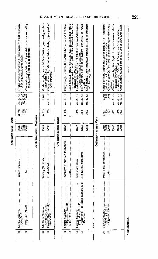
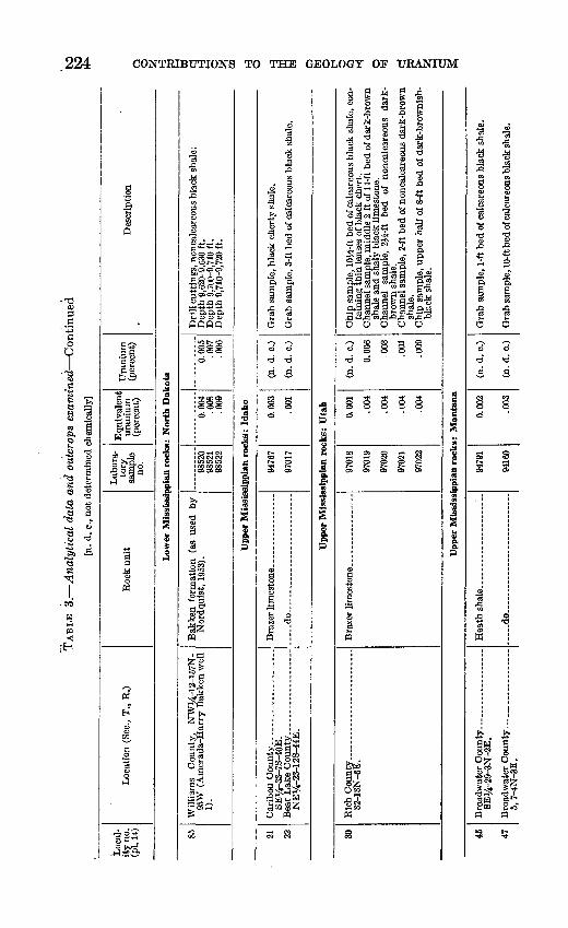
A black shale sequence of early Mississippian (Kinderhook) age, which ranges in thickness from a few inches to as much as 100 feet, occurs locally at the base of the Madison limestone or its equivalents in southwestern and central Montana and in the Williston basin of Saskatchewan, Manitoba, Montana, and the Dakotas. The term "Bakken formation" has been used to identify this unit in the subsurface in the Williston basin, where it is described by Nordquist (1953, p. 72) as mainly "two thin highly radioactive black shales separated by a grey calcareous sandstone, siltstone, or dolomite." According to Nordquist, the upper shale unit may be correlative with a bed of black shale, a few inches to 30 feet thick, which occurs at the base of the Madison or Lodgepole limestones in various parts of southwestern Montana and Utah. The lower shale and medial sandstone-dolomite units may correlate with the Sappington sandstone as used by Holland (1952), a shale and sandstone sequence as much as 60 feet thick, which occurs below the Madison limestone in parts of southwestern Montana. In southern Canada, equivalents of the basal shale unit and medial sandstone-dolomite unit of the Bakken formation, as used by Nordquist (1953), are regarded by him to correlate respectively with the Exshaw shale (of Warren, 1937) and the basal sandstone of the overlying Banff formation (of McConnell, 1887). In most parts of the northern Rocky Mountains region, the Bakken formation (as used by Nordquist, 1953) and its equivalents unconformably overlie the Three Forks or Jefferson formations of Late Devonian age, and they are conformably overlain by limestone of the Madison or Lodge- pole formations, or McConnell's Banff formation, all of early Missis sippian age.
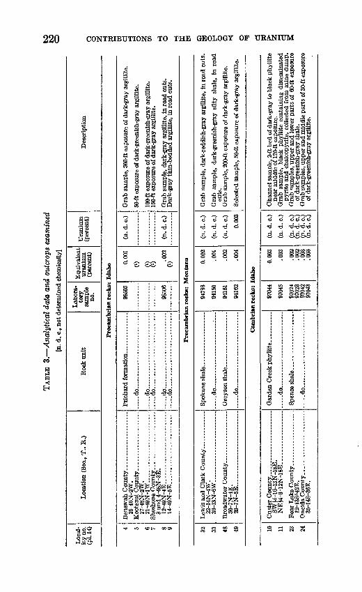
TAB
LE 3
. A
naly
tica
l da
ta a
nd o
utcr
ops
exam
ined
[n
. d. c
., no
t det
erm
ined
che
mic
ally
]
Loc
al
ity
no.
(pl.
14)
Loc
atio
n (S
ec.,
T.,
R.)
Roc
k un
itL
abor
a
tory
sa
mpl
e no
.
Equ
ival
ent
uran
ium
(p
erce
nt)
Ura
nium
(p
erce
nt)
Des
crip
tion
Q O
Frec
ambr
ian
rock
s: I
daho
4 5 6 7 8 9
25-4
6N-2
W.
27-4
8N-2
W.
21-4
9N
-1W
....
. --.. . - ..,
3 an
d 4
-48
N-3
E.
12
-49
N-4
E..
... .
....
....
....
....
....
14-4
9N-5
E. .
....
....
....
. ...... .....
....
.do
....
...
... .
.do
..... ..
.. . .
..
.... .d
o..
..
..
. ...
...
..
do.......
.do...
9850
3
9850
6
0.00
1
0) 0) (0
.002
(n. d
. c.)
(n. d
. c.)
Frec
ambr
ian
rock
s: M
onta
na
32 33 48 49
22-1
4N-4
W.
36-13N-6W.....
. ... .
....
....
. ..
....
.
30-7
N-4E
. 20-7N-5E.... ...
_...
.
.........
... ..do-.. ..
. ..
. .
..do ..
.
94788
9415
0
9416
1
94162
0.00
2
.001
.002
.004
(n. d. c
.)
(n. d. c
.)
(n. d.
c.)
0.00
3
cuts
.
w
Ous
ter
Co
un
ty._
..,
SWJ4
-16-
13N
-18E
.
Bea
r L
ake
Cou
nty.
12-1
38^4
2'E.
O
neid
a C
ounty
....
35-1
4S-3
6E.
Cam
bria
n ro
cks:
Ida
ho
Gar
den
Cre
ek p
hyll
ite
.. d
o........ - .
Spen
ce s
hal
e...
.. -.
.do... .
9704
4 0.
003
(n.
d. c
.)
9704
5 .0
03
(n. d
. c.
)
9702
4 .0
02
(n.
d. c
.)97
023
.002
(n
. d.
c.)
9704
2 .0
03
(n. d
. c.)
9704
3 .0
03
(n. d
. c.
)
Cha
nnel
sam
ple,
2-f
t bed
of d
ark-
gray
to b
lack
phy
lllt
ene
ar m
iddl
e or
120
-ft e
xpos
ure.
G
rab
sam
ple,
bla
ck p
hyll
ite
cont
aini
ng d
isse
min
ated
pyri
te a
nd c
halc
opyr
ite,
colle
cted
fro
m m
ine
dum
p.
Gra
b sa
mpl
es, u
pper
and
low
er p
arts
of
60-f
t ex
posu
reof
dar
k-gr
eeni
sh-g
ray
shal
e.
Gra
b sa
mpl
es, u
pper
and
mid
dle
part
s of
30-
ft ex
posu
reof
dar
k-gr
eeni
sh-g
ray
argi
llite
.
Cam
bria
n ro
cks:
Uta
h
25 28
Cac
he C
ount
y.. _
__________ -
10-1
4N-2
E.
SW
J4-4
-11
N-4
E.
.-..
_..
._..
-.-
..d
o.. . _ . --.
.. _
.
9703
997
040
9704
1Q
7A
0.00
3.0
01
.002
f\f\
K
(n. d
. c.)
(n. d
. c.)
0.00
3
of d
ark-
gree
nish
-gra
y sh
ale.
shal
e, lo
wer
par
t of 1
0-ft
expo
sure
.
Cam
bria
n ro
cks:
Mon
tana
39
46N
WJ4
-14
-3S
-5W
. B
road
wat
er C
ou
nty
. , _____ .
22-5
N-1
W.
9701
2
9479
0
0.00
5
.002
0.00
1
(n.
d.
c.)
dG
rab
sam
ple,
nea
r m
iddl
e of
50-
ft ex
posu
re o
f gre
enis
h-
M
blac
k si
lty s
hale
. >
C
hann
el s
ampl
e, 6
-ft b
ed o
f bl
ack
shal
e, u
pper
par
t of
^
50-ft
exp
osur
e.
£}
3O
rdovic
an r
ock
s: I
dah
oH
12
13 14
15
NE
J4-2
8-1
1N
-17
E.
5-1
1N
-17
E. ..._
_ _
.
SW
^-24-1
0N
-17E
. U
nsu
rvey
ed 15
mil
es n
ort
hea
st o
f K
etch
um
.
Satu
rday
Mou
ntai
n fo
rmat
ion.
. .
....
.do . ....-.. ..
9704
6
9704
7
9705
2
9705
3
0.00
3
.003
.003
.003
(n.
d.
c.)
(n. d
. c.)
(n. d
. c.)
(n. d
. c.)
^\
Chi
p sa
mpl
e, m
iddl
e 10
ft o
f 30-
ft be
d of
dar
k-gr
ay sh
ale.
^
Thi
n-be
dded
bla
ck d
olom
ite a
nd i
nter
bedd
ed b
lack
^
shal
e ex
pose
d in
mai
n ad
it of
the
Red
bird
min
e fo
r a
x
dist
ance
of 1
,000
ft.
w
Gra
b sa
mpl
e, lo
wer
par
t of
200
-ft e
xpos
ure
of d
ark-
gray
^
to b
lack
thin
-bed
ded
argi
llit*
. M
C
hip
sam
ple,
top
25-
ft of
1,7
00-ft
ex
posu
re
of b
lack
M
ar
gilli
te.
t!
Chi
p sa
mpl
e, 1
0-ft
bed
near
mid
dle
of 1
,700
-ft e
xpos
ure
M
of b
lack
arg
illite
. ^ y
O
rdo
vic
ian
ro
cks:
Uta
h
y w
26
27N
WJ4
-5-1
4N
-4E
. N
EU
-18
-12
N-3
E... .
....
....
....
....
.....d
o.... ..
....
......
....
....
....
9702
6 97
024
9703
1
0.00
4 .0
04
.003
0.00
3 .0
03
.003
0
Gra
b sa
mpl
es, u
pper
and
low
er p
arts
of 4
5-ft
expo
sure
CO
of
ver
y da
rk g
ray
nonc
alca
reou
s sh
ale.
S
C
hann
el s
ampl
e. 3
-ft b
ed o
f no
ncal
care
ous
dark
-gra
y m
> Not
sam
pled
.
to
222 CONTRIBUTIONS TO THE GEOLOGY OF URANIUM
§o"S
e 73 8 1
II S 1
^3 %§ *O 13
3 S S a.
£3
alen um
^ *
a"-.3 CD
|a
WOO
B5B
III
33
..H Q>o
Igs3o^T-i §§£§Isls«
woo a>t"5^-25<N flC
O M
8f a
IpO
.y
"8
t3
Si8"aen -H
. . * i j * t*» $ ..£,&&£ a fi ® w_> to co C
fl-So SSSlO EHfcfcfcpq
6§ 666 dcJ'd'd'd
sB BB^
CM r. CM n COo oo oo oooooo
I1I1I
Ig
1
jp»l-l
1.°i110
S
Io£JM
.-4O
4300"3
43e>»ft oa
<D
1»
al »fl sSd^d as85^3 fl^=
D
§o
1
t~
1C3
?M^
|
&
S«3 852
5
1
CDe>»
d d 8 'S
C! -Cfo> o>
3 ."3.- Ss 3 fflP C3 d OS
O 0
§ §42 49
*Sfi Sec dgOTS°P*^oS
\Lm\Lid i W T §i3.S^ Sfe-'SW |ll§ 3 O
M< "5CO CO
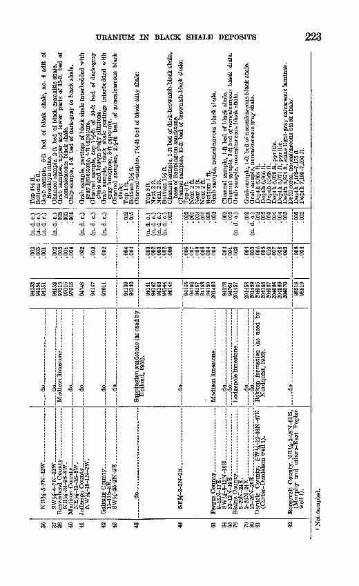
36 37 38 40 41 42 43 43 44 61 64 65 78 79 80 81
82
NE
M-5
-7N
-12
W....... .
............
SW
Ji-4
-7N
-12W
....
....
....
........
NE
M-3
4-9S
-8W
.
NE
M-1
3-3S
-5W
.
NW
M-1
6-1N
-2W
.
11-1
1&-3
E.
SW
M-2
6-2N
-2E
. ...................
....
...d
o..
....
....
....
....
....
....
....
.
8E
J£-2
-2N
-2E
_..
....
___ .
_._
._.
9-13
N-1
7E.
SW
J£-8
-12N
-18E
._ _
-_._
_____ .
32-1
2N-1
9E. .
....
.. .................
5-25
N-2
4E.
2-26
N-2
4E.. ..
....
....
....
....
....
..22
-26N
-25E
. ...
....
....
....
....
....
.D
anie
ls
Cou
nty,
SW
>/4-
12-3
6N-4
7E
(Car
ter-
Dan
iels
on w
ell 1
).
Roo
seve
lt C
ount
y, N
Ei/i
-2-2
8N-5
1E,
(Mur
phy
and
othe
rs-E
ast
Popl
ar
wel
ll).
....
.do-.
..-.
-.-.
. _
__
... _
_
....
. do..
....
....
.. ..
....
....
....
..
-.-d
o..
....
... .
....
....
....
....
..
.....d
o..............
....
....
....
..
-.-.
do..
....
....
....
... .
..........
.....d
o..............
....
....
....
..
Hol
land
, 195
3).
....
.do
....
.......
..............
... .
.do
....
...
....
....
....
....
.. do . ._..
d
o... ...... ..
....
....
....
.....d
o.... ..
....... .
....
. .........
Bak
ken
form
atio
n (a
s us
ed b
y N
ordq
uist
, 19
53).
.....d
o..... . .. ..
....
. .
9415
3 94
154
9415
1
9415
297
015
9701
6 97
013
CU
14S
9414
7
9701
1
9413
9 94
140
9414
1 94
142
9414
3 94
144
9414
5
9415
5 94
156
9415
7 94
158
9415
9 20
1460
9417
694
764
2014
57
2014
58
2040
65
2040
66
2040
67
2040
68
2040
69
2040
70
9851
8 98
519
.002
.0
03
.001
.002
.005
.004
00
4
ft(V
>
.003
.002
.004
.0
04
.003
.0
02
.003
.0
02
.006
.006
.0
07
.008
.0
06
.004
00
4
.004
.004
.003
.004
.003
.006
.0
05
.010
.0
07
.008
.0
03
.006
.0
04
(n.
d. C
.) (n
. d.
c.)
(n.
d. c
.)
(n.
d. c
.).0
03.0
03A
ftl
(n.
d. c
.)
(n.
d. c
.)
(n.
d. c
.)
.002
.0
05
(n.
d. c
.) (n
. d.
c.)
(n.
d. c
.) (n
. d.
c.)
.002
.002
.0
01
.003
.0
01
.005 r\f\
n
.002
.002
(n. d
. c.)
002
(n.
d. c
.).0
02
.002
.0
03
.004
.0
04
.002
.006
.0
02
Top
4V£
ft.
Bot
tom
6 f
t.
Bro
okly
n m
ine.
nonc
alca
reou
s B
lack
sha
le.
gray
lim
esto
ne,
5-ft
expo
sure
. C
hann
el s
ampl
e, t
op I
V^-
ft of
20-
ft be
d of
dar
k-gr
ay
shal
e an
d br
own
shal
y si
ltsto
ne.
gray
lim
esto
ne,
3-ft
expo
sure
.
shal
e:
Top
1 f
t. B
otto
m \yz
ft.
Top
2 ft
. N
ext
2 ft
. N
ext
2 ft
. B
otto
m \yz
ft.
Cha
nnel
sam
ple,
1-f
t bed
of d
ark-
brow
nish
-bla
ck s
hale
, ba
se o
f Sa
ppin
gton
san
dsto
ne.
Top
3 f
t. N
ext
2 ft
. N
ext
2 ft
. N
ext
2 ft
. B
otto
m 1
ft.
Dep
th 6
,964
ft.
Dep
th 6
,966
ft.
Dep
th 6
,968
ft.
Dep
th 6
,970
ft,
pyri
tic.
D
epth
6,9
71 f
t, py
riti
c.
Dep
th 6
,974
ft,
som
e li
ght-
gray
cal
care
ous
lam
inae
.
Dep
th 7
,165
-7,1
75 f
t. D
epth
7,1
90-7
,200
ft.
a § hj
O OJ
GO
' Not
sam
pled
.C
O
224 CONTRIBUTIONS TO THE GEOLOGY OF URANIUM
33)
3.3a02
ig3 ~s Ia, §I -si «3 S
1 13 §3 «w o
! J3 .J 'o2 r5
3iS3
0
da< <
a.2'n'g
Sft
§«'3 §
£ !
J s^
111l^do5 ** (fl
Hi
'3
S
80
«
«8?
CO
Location (
"§ rt 1-1
5e
1A fi
1
!§*gJ"*» .1u.4)^
3
fD
^ a a033
CO
ge
Drill cuttings, noncalcare
Depth 9,620-9,630 ft. Depth 9,700-9,710 ft. Depth 9,710-9,720 ft.
ill0
111o
ill
??
im03^^
CO*
"-3S
a _ 4J
«w "3I"i"rtZpq
||
j3
^|rilliams Count* 95W (Amerada-
1).|£
00
e
iw441§ & J""1
§«p,j^
CD
2 Aijos
i i a I>» ^
Grab sample, black chert Grab sample, 3-ft bed of <
o d d -d
S 5
i sO
§ S
a
1
|
I -i£
aribou County.. SE1/4-33-7S-10E ear Lake Counti
NE1/4-23-12S-W
D pq
(3 ?J
|a S
1Sm.S55
§
i[^
'I 2 -c( 2 pCD ft rO ^
a | § | |t> «H 03 OJ boj o CJ g °*
g .a g g °
l?l §^ 1 J S O *Q ^ O *t^
S^jwS'g £ ""S C3 r<i aft ® O
Chip sample, 10^-ft bed i taining thin lenses of bl Channel sample, middle : shale and shaly black 11 Channel sample, 2^-ft
brown shale.
Channel sample, 2-ft bed
shale.
Chip sample, upper half
black shale.
"e? g S S S o o o o13 0
3.
§ i i i ie5
oo os o .-j egi 1 i 1 CN CM CN
CDsOCO
Is2«
!!Pn
g
OJ
e
91
1eJS"g.*35 son
§
I
| 5
^ _rt
Jd u^ §
3 si is s g -a
Grab sample, 1-ft bed of ( Grab sample, 10-ft bed of c
d d d t3
3 B
<N CO
o
t-H Oo> 25
1
1 §SB
>. ft
roadwater Coun SEV4-29-3N-2E, roadwater Coun
5, 7-4N-3E.
M M
9 ft
70 73
14-9
N-1
0E.
SW1/
4-3-
16N
-10E
.N
EV
4-2-
16N
-10B
... ................
6-15
N-1
2E_.
__._
_. .
..............
, N
E1/
4-11
-14N
-11E
. .................
NW
>/4-
19-1
4N
-12E
_
._
_ _
2&
-12
N-1
4E
.. ....... _
______
21-1
1N-1
5E. _
_ . _
__________
Whe
atla
nd C
ount
y __________
5-10
N-1
3E.
7-10
N-1
3E.. ______________
._ d
o - _
___
7-13
N-1
8E.
NW
Ji-2
3-1
3N
-17
E _ _
.
.....d
o.. . ... _.._..-
6-12
N-2
0E.. ______________
. _ .do-. _
_
SW
M-3
0-16
N-1
9E...
. ________
SW
J£-1
4-15
N-1
9E. .
....
....
....
....
17-1
4N
-2IE
....... _
_____ ..
__
SE
&-3
0-H
N-2
1E
.. ..
. ...
....
....
NE
^-8~
13N
-21E
. ........... _
....
..S
W^-
17-1
4N
-21E
..,_
i __
__
__
_
6W
M-1
6-1
4N
-22
E..
.. _
_ . .
.......
.....d
o.......... ..
....
....
....
....
. .d
o............
....
. ..
....
....
... d
o..
....
....
......
....
....
....
.....d
o... .
.... ..
... .
....
.. ..
....
. ......d
o.... ..
....
....
....
....
....
.... do
....
.do..
.. ..
....
....
....
. ...
....
..
....
.do..
....
....
. .
do .
__._
Otte
r fo
rmat
ion __
__
__
__
__
....
.do
.. _
__
_
So-c
alle
d A
msd
en f
orm
atio
n of
loca
l usa
ge.
- _
do.
do. _
.
__ .
,. .
.. ..
do
...
..
....
.. ..
d
o
.. ...
..
.
loca
l usa
ge.
9416
3
9477
894
779
9478
094
781
9477
3
9477
194
772
9476
694
765
9478
3
9478
594
784
9417
7
9417
394
174
9417
594
755
9475
6
9475
7
9475
8 94
759
9476
0
9476
1 94
762
9478
6
9416
9
9417
8 94
179
9418
2 94
183
9418
4 94
185
9418
0
9419
2
.002
.002
.002
.004
.001
.003
.002
.001
.0
01.0
03.0
01
.002
.003
.002
.003
.004
.0
04.0
01
.001
.001
.002
.0
01
.003
.003
.0
06
.001
.004
.003
.0
02
.002
.0
02
.003
.0
01.0
03
.002
(n.
d. c
.)
(n.
d. c
.)(n
. d. c
.)0.
002
(n. d
. c.)
.002
(n. d
. c.
)(n
. d.
c.)
.002
(n. d
. c.)
(n. d
. c.)
.002
(n. d
. c.)
(n. d
. c.
).0
03
.003
(n. d
. c.)
(n. d
. c.)
(n. d
. c.
)
(n. d
. c.)
(n. d
. c.)
.002
.003
.0
03
.003
(n. d
. c )
(n. d
. c
)
n. d
. c )
n. d
. c )
n. d
. c
)
(n. d
. c )
(n. d
. c.)
Cha
nnel
'sam
ple,
3-f
t bed
of f
ossi
lifer
ous
blac
k sh
ale.
Cha
nnel
sam
ple,
2J4
-ft b
ed o
f gyp
sife
rous
bla
ck s
hale
. C
hip
sam
ple,
12-
ft be
d of
cal
care
ous
blac
k sh
ale.
C
hip
sam
ple,
20-
ft be
d of
non
calc
areo
us b
lack
sha
le.
Gra
b sa
mpl
e, 3
0-ft
bed
of b
lack
sha
le.
Chi
p sa
mpl
e, c
alca
reou
s bl
ack
shal
e in
terb
edde
d w
ithgr
ay li
mes
tone
, 30-
ft ex
posu
re.
Chi
p sa
mpl
es, t
op 6
ft o
f 60-
ft ex
posu
re o
f bla
ck "s
hale
. B
otto
m 6
ft o
f uni
t abo
ve.
Cha
nnel
sam
ple,
2-ft
bed
of c
alca
reou
s bl
ack
shal
e.
Gra
b sa
mpl
e, m
iddl
e of
40-
ft be
d of
bla
ck s
hale
. G
rab
sam
ple,
6-ft
bed
of b
lack
sha
le.
Gra
b sa
mpl
e, 5
-ft b
ed o
f non
calc
areo
us b
lack
sha
le.
Gra
b sa
mpl
e, 4
-ft b
ed o
f non
calc
areo
us b
lack
sha
le.
Gra
b sa
mpl
e, 5
-ft b
ed o
f cal
care
ous
blac
k sh
ale.
Cha
nnel
sam
ple,
5}^
-ft b
ed o
f cal
care
ous
blac
k sh
ale.
C
hann
el s
ampl
e, 4
-ft b
ed o
f cal
care
ous
blac
k sh
ale.
G
rab
sam
ple,
2-ft
bed
of n
onca
lcar
eous
bla
ck s
hale
. G
rab
sam
ple,
20-
ft be
d of
mar
oon
shal
e.
Cha
nnel
sam
ple,
top
4 f
t of
5-ft
bed
of
nonc
alca
reou
sbl
ack
shal
e.
Cha
nnel
sam
ple,
top
4 f
t of
30-
ft be
d of
non
calc
areo
usbl
ack
shal
e.C
hann
el s
ampl
e, m
iddl
e 4
ft o
f sam
e un
it a
s ab
ove.
C
hann
el s
ampl
e, b
otto
m 4
ft o
f sam
e un
it a
s ab
ove.
C
hann
el s
ampl
e, t
op 3
ft o
f 25-
ft be
d of
cal
care
ous
silty
blac
k sh
ale.
Gra
b sa
mpl
e, m
iddl
e pa
rt o
f uni
t ab
ove.
C
hann
el s
ampl
e, t
op 6
ft o
f 70-
ft be
d of
cal
care
ous
silty
blac
k sh
ale.
G
rab
sam
ple,
dar
k-gr
ay n
onca
lcar
eous
sha
le fr
om m
ine
dum
p.G
rab
sam
ple,
3-ft
bed
of b
lack
sha
le.
Cha
nnel
sam
ples
, 15-
ft be
d of
non
calc
areo
us b
lack
sha
le:
Top
V4
ft.
Nex
t 1
ft.
Cha
nnel
sam
ples
, 15
-ft b
ed o
f cal
care
ous
blac
k sh
ale:
T
op 2
J^ ft
. N
ext V
/z ft
. B
otto
m 6
ft.
Gra
b sa
mpl
e, 1
0-ft
bed
of b
lack
non
calc
areo
us s
hale
. C
hann
el s
ampl
e, b
otto
m 2
ft
of 3
-ft
bed
of c
alca
reou
sbl
ack
shal
e.
Gra
b sa
mpl
e, 4
-ft b
ed o
f non
calc
areo
us b
lack
sha
le.
a 8 CO to
to
226 CONTRIBUTIONS TO THE GEOLOGY OF URANIUM
g3Bd0J3S
chemically]
i ^1 S^ ©S rQ
§ a8 a3 cls * * ^-^ H
|«
5
0
3£)«!-i
}
If
^ft
Equivalent uranium (percent)
l^dis i fl
i_2§p?
£03
qo
il
i_c
intana Com
i
1§ai1§a,*
2 J2 -+JO o ^qj qj bO
r-4 * O
S S -d
1 1 1| s .a;W +a «0
M "* ' §
a «-i cs ® o PI
1h
ao
5
1 ..o !1 2o _^
+* » S> « la& & a 5**Lj W O ^ t>i
» fe ^ i»r *ft £. o Q. ** t->. & i iiliL^Ijlflpl'iiil2l2iNS|3»«>-3'a -3<a >t %'£&aaa ,Q C3,Q C3,Q C3S SJ3-W+?-"2S2S2&§o !5 aaa O O 0 £ fiQfifi
cj o o
mo ° ° JT*
oo oo c£^ r-H ^
Cb eft eft
O a
I 'S
e
"3 wfg |i-2 §fl§ Va£2 iSV « 0^ 4,|S ^ S® «
PH
c c
OOO
SINCOCOOOO 000
?2t22!
1^ ^
5 i * 5.>> we?
§ ^|
>* I &® P-? O
S3 W
> ^12 Soo d^
S g fc S
c
|OM
2£
IM
11a§K ***
itW| M'
Tay and dark-greenish-gray ai ad cuts and at natural exposure
lactivity. is above. is above.
£ «^ o> v
£S~ ^ cl S Q CQCQ
£ S£
Isg>sfflQ
3 c ca re reH
P
t« 4
If tlDCQ OD 1N r-lCQ
jS4i cict«co co
rt INTO
rt
OSS c oS
jiun
I
C3 f> Q ^
V °3 S* H "§« .-§ .-g>rt S § '^"firS
s i! ll-s .* ? 3 ^3 ^s*a> § §3 ^ rH'O §
sample, near middle of 60-ft t ninous shale (top of the sequen el sample, bottom IJi ft of sar ample, ^-ft bed of dark-gray 1 el sample, 1-ft bed of light-yello ample, 4-ft bed of black bitumi el sample, top 3 ft of 25 ft b< ninous shale (base of the sequel
jaSy-OonftS-S 23,a 2t5.a3.a2 O DO ODD
o do So **rci rcjrrj o ' «'
S S3. fl
O OO OOO O OO OOO
0
00 C»0 ^JNW
§ oiiig olo?S
a ao"2CO§ 3o
i"0*7d^2T§CO
53 74
Judi
th B
asin
Cou
nty _________
1-16
N-1
1E.
Ferg
us C
ou
nty
....
__________
NW
^-20
-14N
-24E
.
....
.do..
....
.....................
....
.do
....
....
....
....
....
....
...
9477
7
9477
6
9477
5
9477
4
9418
9
.005
.002
.002
.002
.002
.003
(n. d
. c.
)
(n. d
. c.
)
(n. d
. c.
)
(n. d
. c.
)
uppe
r pa
rt o
f 25
-ft
bed
of y
ello
wis
h-gr
ay b
ento
nite
. C
hann
el s
ampl
e, b
otto
m I
tf f
t of
25-
ft be
d of
yel
low
is
h-gr
ay b
ento
nite
. G
rab
sam
ple,
^-f
t be
d of
gra
y si
licif
ied
shal
e, u
nder
- ly
ing
bed
of b
ento
nite
des
crib
ed a
bove
. C
hann
el s
ampl
e, 4
-ft
bed
of d
ark-
gray
sha
le,
unde
r
lyin
g un
it a
bove
.
mid
dle
of a
30-
ft ex
posu
re o
f in
terb
edde
d sh
ale
and
yello
wis
h-gr
ay s
ilty
san
dsto
ne,
base
of
the
Col
orad
o sh
ale.
1 Not
sam
pled
.
to
228 CONTRIBUTIONS TO THE GEOLOGY OF URANIUM
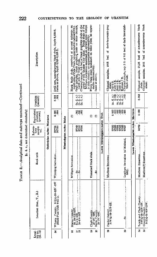
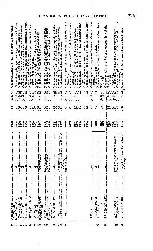
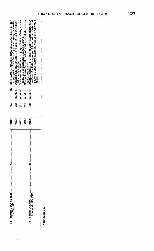
The black shale sequence at the base of the Madison limestone was sampled at 17 localities in the mountainous parts of southwestern aad central Montana and northwestern Utah. Sections at 10 of these localities are shown in figure 52. The maximum observed uranium content of the sequence is 0.005 percent, in the lower half of a 2K-foot- thick bed of black shale near Three Forks, Mont. (loc. 43), and 0.005 percent in the basal part of a 10-foot bed of brownish-black shale nearby (loc. 44).
The Bakken formation (as used by Nordquist, 1953) was sampled in three wells, two of them in northeastern Montana and the third in northwestern North Dakota. Drill cuttings representing 30 feet of black shale from one of the wells, Amerada Petroleum Corpora tion-Harry Bakken well 1, Williams County, N. Dak. (well 15, table 1), contain 0.005 to 0.007 percent of uranium. A sample of drill core from a 10-foot-thick bed of black shale in the C. H. Murphy, Jr., and others-East Poplar well 1, Koosevelt County, Mont., sec. 2, T. 28 N., K. 51 E., contains 0.006 percent of uranium. One of six samples of drill core from a 10-foot-thick bed of black shale in the Carter Oil Company-S. W. Danielson well 1, Daniels County, Mont., sec. 12, T.36N.,K.47E., contains 0.004 percent of uranium. The samples from this well are anomalous in that they are decidedly out of balance in favor of equivalent uranium, as indicated in the following table:
Descriptions of samples: Carter Oil Company-S. W. Danielson well 1, DanielsCounty, Mont.
Sample no.
204065 204066 204067 i .- -204068 204069 .. -.204070
Depth (feet)
696469666968697069716974
Description
- do. - - . . --
laminae.
eU (percent)
0.006.005.010.007.008.003
U (percent)
n fin?.002.003.004.004.002
i J. N. Rosholt, Jr., U. S. Geological Survey Trace Elements Laboratory, investigated the source of the high radioactivity in sample 204067, with the following result:
Equivalent uranium (percent)______________________ - ______ -__ - _ 0.010 Uranium (percent)________________________-_____ ___...____ .003 ThMss (radio-chemical) (percent). ___ ..._._ .. .- .. ................... .003Th^o (ionium) (percent equivalent).. .... - ..... ....... .009Radium (percent equivalent)_ --__ . .... .006
The analysis above indicates that Th230 and radium, both daughter products of uranium, are the principal contributors of excess radio activity. The relatively high concentrations of these elements in comparison to uranium suggest that leaching of uranium or addition of Th230 and radium has occurred in this deeply buried shale [in comparatively recent time.
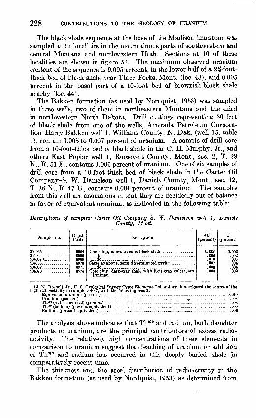
The thickness and the areal distribution of radioactivity in the Bakken formation (as used by Nordquist, 1953) as determined from
______CARBONIFEROUS______________
DEVONIAN ' ~ MISSI3SIPPIAN.
Jefferson VLeatham formation formation' | of Holland, 1952_______ __________Madison toiestone
Lower black shale member
iTH
230 CONTRIBUTIONS TO THE GEOLOGY OF URANIUM
published sample descriptions and gamma-ray logs, are shown in plate 15. These maps suggest that black shale in the Bakken forma tion (as used by Nordquist, 1953) is thickest in the northwestern corner of North Dakota and that the formation is most radioactive slightly east of this area, near the northeastern corner of Montana. It seems evident that radioactivity in the Bakken formation (as used by Nordquist, 1953) varies appreciably from place to place with a definite pattern. Recognition of the pattern will help in outlining areas in which maximum concentrations of uranium in the formation may be expected.
BLACK SHALE AT THE BASE OF THE BBAZEB LIMESTONE
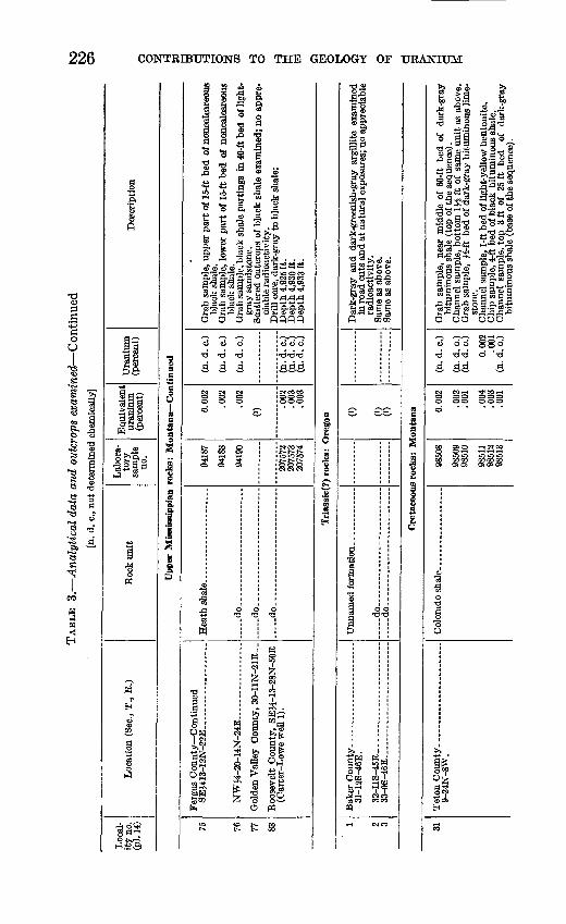
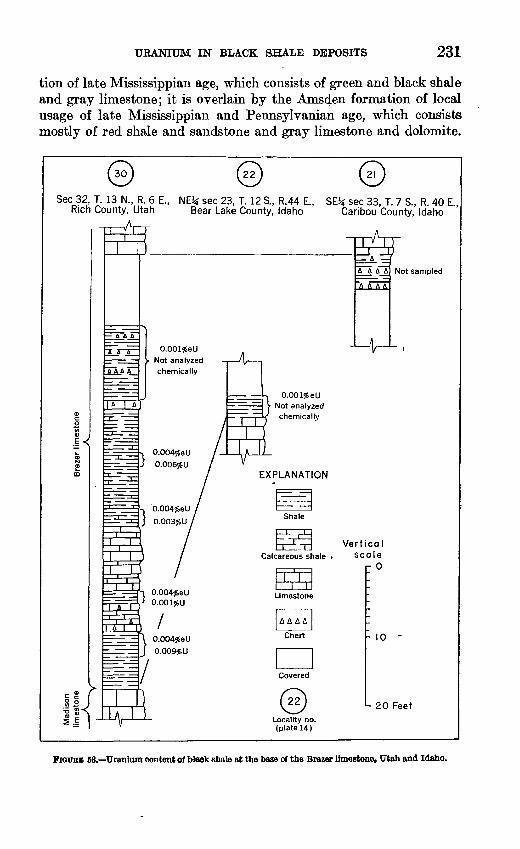
In parts of Utah and Idaho the basal part of the Brazer limestone of middle and late Mississippian age consists of a black phosphatic shale sequence ranging in thickness from a few inches to about 75 feet. Exposures of this zone were tested at two places in south eastern Idaho (Iocs. 21 and 22), and at one place in northwestern Utah (loc. 30). Beds of black shale at the two Idaho localities are mostly nonuraniferous, but in Rich County, Utah, a bed of shale 14 feet thick in the upper part of the sequence contains as much as 0.006 percent of uranium, and a bed of shale 8 feet thick in the lower part contains as much as 0.009 percent of uranium. The measured sections and uranium content of the black shale at the three localities are shown hi figure 53.
Black shale at the base of the Brazer limestone was examined by Duncan (1953) in Ogden Canyon, Weber County, Utah, about 45 miles southwest of the Rich County locality described above. In Ogden Canyon, Duncan reported, beds of phosphatic shale about 1 foot thick contain as much as 0.005 percent of uranium, 0.18 percent of vanadium oxide, and 17.3 percent of phosphate.
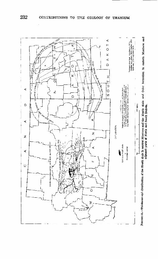
HEATH SHALE
The Heath shale of late Mississippian age crops out along the mar gins of the Little Belt and Big Snowy Mountains in central Montana, and it has been penetrated in drill holes throughout a large area in eastern Montana and western North Dakota. The formation con sists mainly of black shale, with subordinate amounts of gray lime* stone and fine- to coarse-grained sandstone. It is as much as 650 feet thick in the subsurface in the northeastern corner of Mussel- shell County, Mont., and it is as much as 400 feet thick where it is exposed on the flanks of the Little Belt and Big Snowy Mountains to the west. (See fig. 54.) The Heath is underlain by the Otter forma-
URANIUM IN BLACK SHALE DEPOSITS 231
tion of late Mississippian age, which consists of green and black shale and gray limestone; it is overlain by the Amsden formation of local usage of late Mississippian and Pennsylvanian age, which consists mostly of red shale and sandstone and gray limestone and dolomite.
Sec 32, T. 13 N., R. 6 E., NEJ* sec 23, T. 12 S., R.44 E., SE3* sec 33, T. 7 S., R 40 E Rich County, Utah Bear Lake County, Idaho Caribou County, Idaho
A A A A Not sampled
- 10 -
- 20 Feet
FIGUBB 63. Uranium content of black shale at the base of the Brazer limestone, Utah and Idaho.
232 CONTRIBUTIONS TO THE GEOLOGY OF URANIUM
11<a 5C8 _.a 3
II

URANIUM IN BLACK SHALE DEPOSITS 233
Outcrops of the Heath shale were examined for radioactivity at 8 places by W. J. Hail and J. K. Gill in 1951 (in Duncan, 1953), and out crops of the Heath shale were examined at 24 places by the writer in 1953. The most highly uraniferous black shale thus far found in the formation was discovered by Hail and Gill 3 miles southeast of Forest- grove, Mont., in the NWK sec. 24, T. 14 N., K. 20 E., Fergus County. At this locality, the upper 4 feet of a bed of black shale 6 feet thick near the top of the formation contains 0.006 percent of uranium. Samples of black shale from the Heath shale elsewhere in central Montana contain a maximum of 0.003 percent of uranium.
A sample of water from a seep in the upper part of the Heath shale on the north flank of the Big Snowy Mountains (loc. 66) contains 7 parts per billion of uranium.
The Heath shale is characterized locally by large deflections on gamma-ray logs of oil and gas wells. A bed 10 feet thick in the Heath shale penetrated by the Marigold Oil, Ltd.-Farnham well 1, McCone County, Mont, (well 3, table 1), may contain more than 0.01 percent of equivalent uranium; and gamma-ray logs show some parts of the formation in Musselshell County, Mont., to be almost as radio active. Not enough information is available so far to attempt to analyze the distribution of radioactivity in relation to the variations in thickness and lithology of the Heath.
LITERATURE CITED
Anderson, S. B., 1954, Stratigraphic sections of the Mississippian system in NorthDakota: N. Dak. Geol. Surv. Dept. of Inv. no. 16.
Baillie, A. D., 1953, Devonian system of the Williston Basin area: ManitobaDept. Mines and Nat. Res., Mines Br., Pub. 52-55.
Barnes, T. R., 1952, The Williston Basin a new province for oil exploration:Billings Geol. Soc. Guidebook, 3d Ann. Field Conf., Williston Basin-Black Hills,p. 97-117.
Duncan, D. C., 1953, Reconnaissance investigations for uranium in black shaledeposits of the Western States during 1951 and 1952: U. S. Geol. SurveyTEI-381, U. S. Atomic Energy Comm., Tech. Inf. Service, Oak Ridge, Tenn.
Gardner, L. S., Hendricks, T. A., Hadley, H. D., and Rogers, C. P., Jr., 1946,Stratigraphic sections of Upper Paleozoic and Mesozoic rocks in south-centralMontana: Mont. Bur. Mines and Geology Mem. no. 24.
Gott, G. B., and Hill, J. W., 1953, Radioactivity in some oil fields of southeasternKansas: U. S. Geol. Survey Bull. 988-E, p. 69-122.
Holland, F. D., Jr., 1952, Stratigraphic details of lower Mississippian rocks ofof northwestern Utah and southwestern Montana: Am. Assoc. PetroleumGeologists Bull., v. 36, no. 9, p. 1697-1735.
McConnell, R. G., 1887, Report on the geological features of a portion of theRocky Mountains, accompanied by a section measured near the 51st parallel:Geol. and Nat. History Survey of Canada, Ann. Rept. (new ser.) v. 2,p. 1D-41D.
234 CONTRIBUTIONS TO THE GEOLOGY OF URANIUM
Nieschmidt, C. L., 1953, Subsurface stratigraphy of the Heath shale and Amsden formation in central Montana: U. S. Geol. Survey Oil and Gas Inv. Chart OC50.
Nordquist, J. W., 1953, Mississippian stratigraphy of northern Montana: Billings Geol. Soc. Guidebook, 4th Ann. Field Conf., Little Rocky Mts., Mont., southwestern Saskatchewan, p. 68-82.
Perry, E. S., 1937, Natural gas in Montana: Mont. Bur. Mines and Geology, Mem. no. 3, 96 p.
Sonnenberg, F. P., Rader, M. T., and Clement, J. H., 1952, Electric and litho- logic cross-section from Norcanols Ogema [well] to Weller-Bush-Weisman [well]: Billings Geol. Soc. Guidebook, 3d Ann. Field Conf., Williston Basin- Black Hills.
Vine, J. D., 1956, Geology of the Stanford-Hobson area, Judith Basin and Fergus Counties, Mont.: U. S. Geol. Survey Bull., 1027-J, p. 405-469.
Warren, P. S., 1937, Age of the Exshaw shale in the Canadian Rockies: Am. Jour. Sci., 5th ser., v. 33, no. 198, p. 454-457.
INDEX
Bakken formation as used by Nordquist, cor relation__ 219
radioactivity, thickness and areal distri bution of. - 228,230
uranium content in drill cuttings 228 Banff formation of McConnell, correlation 219 Big Snowy Mountains..--. __ - 230-233 Brazer limestone)' black shale at base of, de
scription, radioactivity_ 230
Daniels County, Mont.. . 228
Exshaw shale of Warren, correlation.. .. 219
Forestgrove, Mont.. ... 233
Gamma-ray logs, use in present study. 214 value of sensitivity scale...._ .. 214
Geologic formations, stratigraphic relations of,table... .. __.. _ 212
Heath shate, description, radioactivity._.. 230,233
Jefferson formation, correlation. .. _ - 219
Page Little Belt Mountains. ... 230
McCone County, Mont 233 Madison limestone and equivalents, black
shale at base of, description, cor relation.. 219
uranium content observed.. __._ 228 Musselshell County, Mont. 233
Ogden Canyon, Utah 230
Phosphoria formation, excluded from presentstudy__ . 213
Koosevelt County, Mont . 228
Sappington sandstone as used by Holland,correlation_ . __ 219
Three Forks formation, correlation. __ 219 Three Forks, Mont- 228
Williams County, N. Dak.._________ 228
o
235