urban design report: principles and recommendations · 6 lower yongeurban design report 01 1.1...
TRANSCRIPT

Urban Design Report: Principles and Recommendations AUGUST 2014

URBAN DESIGN REPORTLOWER YONGE
TOC
PREPARED FOR
WATERFRONT TORONTO20 BAY STREET, SUITE 1310TORONTO, ONTARIO M5J 2N8+1.416.214.1344
CITY OF TORONTO100 QUEEN STREET WESTTORONTO, ONTARIO M5H 2N2
PREPARED BY
PERKINS+WILL2 BRYANT STREET, SUITE 300SAN FRANCISCO, CA 94105+1.415.856.3000
ARUP77 WATER STREET, NEW YORK CITY, NY 10005+1.212.896.3000

TOC
INTRODUCTION
1.1 Introduction
1.2 Study Area
1.3 Report Summary
1.4 Consultation
BACKGROUND AND CONTEXT
2.1 Policy Context
2.2 Built Form Context
2.3 Heritage Context
2.4 Transportation Context
PRINCIPLES AND GOALS
3.1 Introduction
3.2 Ease of Movement
3.3 Well-Loved Public Places
3.4 Pedestrian Comfort
3.5 Diversity of Uses
3.6 Good Urban Form
LAND USE RECOMENDATIONS
PUBLIC REALM RECOMMENDATIONS
5.1 Introduction
5.2 Street Network
5.3 Sidewalk Zones
5.4 Harbour Street
5.5 North-South Streets
5.6 Public Parkland
5.7 Privately Owned Publicly Accessible Spaces (POPS)
5.8 Public Art
BUILT FORM RECOMMENDATIONS
6.1 Introduction
6.2 Base Buildings: Height and Articulation
6.3 Base Buildings: Setbacks
6.4 Base Buildings: Ground Floor Animation
6.5 Base Buildings: Parking, Loading and Servicing
6.6 Tall Buildings: Height
6.7 Tall Buildings: Floor Plates
6.8 Tall Buildings: Stepbacks
6.9 Tall Buildings: Tower Area Ratio and Separation
6.10 Demonstration Plans
TABLE OF CONTENTS
1
2
3
4
5
6
5
6
8
9
9
11
12
16
20
22
25
26
26
28
30
31
32
35
39
40
42
45
46
52
54
56
58
61
62
64
66
68
70
72
74
76
78
80

URBAN DESIGN REPORTLOWER YONGE
02

021 INTRODUCTION 6
8
9
9
1.1 Introduction
1.2 Study Area
1.3 Report Summary
1.4 Consultation

6 URBAN DESIGN REPORTLOWER YONGE
01
1.1 INTRODUCTIONThis Lower Yonge Urban Design Report: Principles and Recommendations (“UDR”) articulates the overall urban design vision for the Lower Yonge precinct and is intended to provide guidance to the public, stakeholders and decision makers in implementing that vision. The UDR was jointly developed by Waterfront Toronto and the City of Toronto.
As with all waterfront precincts, in accordance with the Central Waterfront Secondary Plan (“CWSP”), Lower Yonge is intended to be “a unique place of beauty and quality” with an identity that is integrally tied to its waterfront context. The CWSP provides direction for the mixed-use revitalization of waterfront lands and are thus legislatively required to be comprehensively planned at a precinct level. This Urban Design Report is an
provides the vision for the precinct as articulated by its principles and recommendations.
Concurrently with the UDR, the Lower Yonge Transportation Master Plan Environmental Assessment (“TMP”) was undertaken and completed. The TMP is the road map for the transportation and infrastructure investments required to support the redevelopment of Lower Yonge. Together, the UDR and TMP have been coordinated to develop a comprehensive streets and blocks plan and identify the transportation infrastructure requirements for the precinct.
This document provides recommendations to be
Precinct Plan (“Precinct Plan”) and subsequent implementation instruments, which may include
subdivision, among other tools. The Precinct Plan will
for community services and facilities, servicing infrastructure, heritage, affordable housing and the development of phasing and implementation tools.
1 INTRODUCTION
Figure 1.1 - Toronto’s skyline

7URBAN DESIGN REPORTLOWER YONGE
01
1 INTRODUCTION
Figure 1.2 - Urban Design Vision for the Lower Yonge Precinct

8 URBAN DESIGN REPORTLOWER YONGE
01
1.2 STUDY AREAThe Lower Yonge Precinct is an approximately 12-hectare area at the heart of Toronto’s transforming Central Waterfront and part of Toronto’s fastest growing community. The study area is prominently positioned within the waterfront and bounded by Queens Quay East to the south, Gardiner/ Lake Shore Blvd corridor to the north, Yonge Street to the west and Lower Jarvis Street to the east.
Since this waterfront precinct is so centrally located, its skillful and appropriate revitalization is critical to the waterfront’s success. Currently comprising a range of employment and retail uses, the Lower Yonge Precinct has large opportunity sites with the potential to accommodate growth and vibrant mixed-use community. The precinct also has the potential to provide a much-needed critical link between other waterfront precincts and the downtown core through its proposed public realm and built form elements.
Figure 1.3 - Lower Yonge Site with Study Area Boundary
Queens Quay
Gardiner Expressway
Harbour Street
Lake Shore Boulevard
Yong
e Stre
et
Jarv
is S
tree
t
1 INTRODUCTION

9URBAN DESIGN REPORTLOWER YONGE
01
Stakeholder Advisory Committee
Public Meetings
Landowner Consultation
Website Resources
Urban Design Report: Principles and Recommendations
Transportation Master Plan EA
Precinct Plan Phase 1 Streets and Blocks, Building Heights and Massing, Park Location
Technical Advisory Committee
Figure 1.4 - Process Diagram Representing How This Report Was Developed
July 7, 2014), Technical Advisory Committee (TAC) meetings (May 22, 2013, September 9, 2013, July 7, 2014), Landowner consultation meetings (May 2, 2013, September 9, 2013, July 8, 2014), and Public Information meetings (May 22, 2013, October 10, 2013). Each public meeting was publicly advertised in addition to being promoted on social media.
The feedback provided by the above noted meetings
principles and recommendations. At each meeting, the team presented a summary of work to date and sought input from participants on a range of issues and opportunities relevant to each stage of the process. The Urban Design Report: Principles and Recommendations will be presented to the SAC, TAC, Landowners and the public for additional feedback as the Precinct Plan and its implementing policies are developed and potentially
1.3 REPORT SUMMARYThis Urban Design Report: Principles & Recommendations (“UDR”) proposes land use, public realm and built form recomendations based on a set principles. The following is a high level summary of the key recommendations:
• The UDR and TMP recommends that the scale of the existing three large blocks be broken down to create eight city blocks by
from Yonge Street to Lower Jarvis Street and introduction of a “New Street” north-south between Cooper Street and Lower Jarvis
serves to improve connectivity of the precinct to the waterfront and the downtown while balancing regional and local transportation needs;
• The UDR recommends the creation of a central park which serves as the heart of the community and key to creating a new waterfront neighbourhood that achieves the core principles in the CWSP: making connections, spectacular parks and open spaces, greening and building new communities;
• Built Form Recommendations have been developed to be consistent with past waterfront precinct plans to the east while acknowledging its contextual relationship to the downtown core to the west and the St Lawrence community to the north. Built Form Recommendations were carefully considered for the base buildings and towers to ensure they address consultation feedback and respond to human scale;
• Collectively the principles and recommendations in this report have been developed in concert to ensure the precinct
has a good mix of uses, a pedestrian and bike friendly environment, safe and comfortable
a vibrant public realm, appropriate building base heights, tower dimensions, and tower placement that meet the objectives of for all waterfront communities.
Overall, the precinct seeks to set a high standard for urban design, appropriate for its large opportunity sites and its privileged waterfront location and in the tradition of prior waterfront precinct planning initiatives to date.
1.4 CONSULTATION The TMP and UDR were developed concurrently in consultation with the public and stakeholders. These consultations included Stakeholder Advisory Committee (SAC) meetings (May 2, 2013, September 9, 2013,
1 INTRODUCTION

URBAN DESIGN REPORTLOWER YONGE
02

022.1 Policy Context
2.2 Built Form Context
2.3 Heritage Context
2.4 Transportation Context
2 BACKGROUND AND CONTEXT12
16
20
22

12 URBAN DESIGN REPORTLOWER YONGE
02
2.1 POLICY CONTEXT
2.1.1 OFFICIAL PLAN POLICIESThe Lower Yonge Precinct is located in the Downtown and Central Waterfront (Urban Structure map of the
CWSP. It is a designated Regeneration Area, with the exception of the Yonge Street frontage, which is designated Parks and Open Space.
The Downtown and Central Waterfront offer opportunities for employment and residential growth.
guided by the Central Waterfront Secondary Plan. The
well-designed connections between the rest of the city and the Central Waterfront. The renewal of the Central Waterfront will create new opportunities for business development, as well as new neighbourhoods with homes for Downtown workers. These policies also acknowledge the opportunity to extend the Financial District south of the rail corridor, which has the potential
Regeneration Areas are blocks of land that may be subdivided for a wide variety of mixed-use
each Regeneration Area, a framework for new development will be set out in a Secondary Plan and development should not proceed prior to its approval. The CWSP does not itself contain a framework for new development but instead requires the development of precinct implementation strategies, while setting out how these strategies will determine the scale of future development, range of uses and the relationship between building massing, density and public spaces for Regeneration Areas. Lands designated Parks and Open Space Areas in the vicinity of Regeneration Areas may be subject to Precinct Implementation Strategies.
2.1.2 CENTRAL WATERFRONT SECONDARY PLAN POLICIES
The purpose of the CWSP is to identify key public priorities and opportunities, and provide an implementation process. The Central Waterfront Plan is built on four core principles:
A. Removing Barriers/Making Connections;
B. Building a Network of Spectacular Waterfront Parks and Public Spaces;
C. Promoting a Clean and Green Environment; and
D. Creating Dynamic and Diverse New Communities.
The CWSP was approved by City Council in 2003, and is subject to various appeals to the OMB, it has been the guiding policy document for waterfront re-development and policy implementation. The CWSP
implementing by-laws have been adopted.
Precinct plans and subsequent implementing zoning by-laws have been developed for the East Bayfront Precinct, West Don Lands Precinct, and the Keating Channel Precinct of the Lower Don Lands. Other precinct planning processes are underway for Cousin’s Quay (Villier’s Island), and the Film Studio Precinct.
Precinct implementation strategies are detailed in Section 2.1 of the CWSP to provide “comprehensive and orderly development” and to implement the policies of the CWSP. The Study Area falls within the “Regeneration Areas” Land Use designation, and is subject to Precinct Implementation Strategies by the CWSP. To achieve what is envisioned in the CWSP, the approval of new zoning for lands within the Regeneration Areas will take place at a precinct level. The policies require that, prior to the preparation of zoning by-laws or development permit by-laws within the Regeneration Areas, Precinct Implementation
Figure 2.1 - Policy Context
LOWER YONGE PRECINCT PLAN
CENTRAL WATERFRONT SECONDARY PLAN
CWSP - LAND USE PLAN
TORONTO OFFICIAL PLAN URBAN STRUCTURE
2 BACKGROUND AND CONTEXT

13URBAN DESIGN REPORTLOWER YONGE
02
Strategies will be prepared in accordance with the policies in Section 2.2. As well, individual site rezonings within Regeneration Areas will generally be considered only once a context has been established through the Precinct Implementation Strategies, for
area-wide infrastructure requirements are required to have been determined with fair and equitable means
provision.
Precinct Implementation Strategies (“Precinct Plans”), including:
• A streets and blocks structure;
• Minimum and maximum standards for building height and massing;
• Strategies to ensure a balance between residential and employment based development;
• Strategies for achieving affordable housing targets;
• Location and phasing of local and regional parks, open space, public use areas and trails;
• Location and phasing of schools, libraries, community/recreation centres, day care, etc;
• Environmental performance standards;
• Provisions for securing the retention of heritage buildings;
• Urban design and public art provisions;
• Provisions to secure necessary roads, transit, trails and bike paths; and
• Financial mechanisms
This Urban Design Report is intended to provide input into a Precinct Plan for Lower Yonge, which will comprehensively address the elements of Precinct
Together with the Precinct Plan and TMP, a context for the evaluation of future applications for municipal development approvals will be established, and
development.
2.1.3 FORMER CITY OF TORONTO OFFICIAL PLANThe CWSP is the guiding document for waterfront redevelopment and precinct level planning in the
this Urban Design Report, the former City of Toronto
Planning decisions must conform to the OP and be
supports the precinct planning approach and level of analysis.
Plan sets out a policy framework, and goals and objectives for the waterfront that were carried forward in the development of the CWSP. These include the primary goal for the waterfront, as set out in Policy 14.2, to promote increased and sustainable public enjoyment and use of the area by ensuring that future developments and action by both the public and private sectors will help achieve CWSP objectives, including: the improvement of public access to the waterfront, increased public parkland across the waterfront, and enhancing the quality of the waterfront as a destination. Development heights are to step down towards the water and views of the lake from the City to the water
Street state that building heights are to generally decrease in a west to east direction across the site, resulting in lower buildings along Freeland Street, which respect the built form scale of the East Bayfront.
recommendations of this report.
2 BACKGROUND AND CONTEXT

14 URBAN DESIGN REPORTLOWER YONGE
02
Like the East Bayfront an Keating Channel precincts, Lower Yonge’s planning context is the waterfront framework, which is most strongly articulated in the CWSP and advanced through precinct plans. It is appropriate for the primary objectives noted above to be integrated into the Lower Yonge Precinct plan, although with consideration of Lower Yonge’s site-
core.
The built form and planning context of Lower Yonge have been carefully reviewed to inform the development of urban design principles and recommendations, and will continue to be considered in the development of the Lower Yonge Precinct Plan.
2.1.5 ZONING The base zoning within the Lower Yonge Precinct includes permission for commercial and industrial development with total densities ranging from 3.0 to
by-law exception 12(2)297 was approved in 1995 as part of an OMB settlement and, establishes height and massing standards for the site located at 1-7 Yonge Street. The exception does not change the zoning designation.
approved as part of an OMB settlement in 1995, established maximum height limits for the1 Yonge site, but did not change the zoning designation. The permitted height and massing steps down west to east, and seeks to preserve views to the south. Maximum base building height adjacent to all streets is 19 metres. Above this height upper storeys must step back a minimum of 2 metres. Adjacent to Queens Quay and Freeland upper storeys must step back again, 12 metres, at a height of 30 metres. Above this a maximum height of 85 metres is permitted along
2 BACKGROUND AND CONTEXT
2.1.4 WATERFRONT TORONTOIn 1999, Prime Minister Jean Chretien, Premier
formation of a task force to make recommendations for developing Toronto’s waterfront. The task force determined that revitalization of Toronto’s waterfront is essential. Notable recommendations were the notions that a “compelling comprehensive concept” for the waterfront is necessary, and that “the waterfront must be, and be seen and understood to be, public to the greatest extent possible,” and that new built form must reinforce the public nature of the waterfront, including access ways to the water’s edge. Waterfront Toronto was established in 2001, largely in response to the recommendations of the Task Force report.
Waterfront Toronto has led the preparation of precinct plans for numerous precincts. Immediately east of Lower Yonge are the East Bayfront and Keating Channel precincts, both of which are south of the Gardiner Expressway and incorporate Queens Quay. Although each precinct along the waterfront will vary in design and character, the precinct plans prepared are for these areas are grounded in the principles of the CWSP and include the following common characteristics:
• an extensive network of park spaces connected by well designed, tree lined streets and augmented with publicly accessible open space on private lands;
• a predominantly mid-rise character;
• a limited number of strategically located taller buildings;
• a mix of commercial, residential uses, as well as community services and amenities;
• easy access to public transportation and
• a supply of affordable rental accommodation as well as market housing.

15URBAN DESIGN REPORTLOWER YONGE
02
2.1.7 CITY-WIDE TALL BUILDING DESIGN GUIDELINESThe city-wide Tall Building Design Guidelines were approved by City Council in May 2013. The Design Guidelines are a consolidated set of performance measures for all tall building development applications city-wide. The Lower Yonge Precinct is located within the CWSP and is therefore not subject to the Downtown Tall Buildings: Vision and Supplementary Design Guidelines (adopted by City Council in July 2012 and consolidated with the city-wide Tall Building Design Guidelines May 2013).
The large opportunity sites in Regeneration Areas, such as those within the Lower Yonge Precinct, are
have multiple existing built form constraints and an existing development context to respond to. As such,
City-wide Tall Building Design Guidelines represent
built-form approach. The Tall Building Guidelines call for the development of Master Plans to provide a framework to guide development of large or complex areas.
for large sites within precinct, including those over 2 hectares, and for those with potential for multiple tall buildings, or new open spaces, and for developments that will be built out in multiple phases.
the Yonge Street frontage; a maximum height of 60 metres is permitted for the Lake Shore Boulevard and Freeland Street portion of the site, and a maximum height of 44 metres is permitted for the Queens Quay East and Freeland Street portion of the site.
2.1.6 URBAN DESIGN GUIDELINES 1 YONGE STREETPolicy 1 in Section 5.3.2 - Implementation Plans
states that guidelines will be adopted to advance the vision, objectives, and policies of the Plan. Urban
a more detailed framework for built form and public improvements in growth areas.” This report builds on the directions of existing guidelines by providing
design of the Lower Yonge Precinct.
law exception for the site. The concepts outlined include subdividing the block with a future extension
metres adjacent to Yonge with massing stepping down west to east and north to south, and setbacks at grade to the west, south and east in favour of the public realm. The setback adjacent to Yonge Street ranges from 6 to 17 metres and is designated as Parks and Open Space Area in the CWSP. The guidelines also call for a visual connection between landscaped open space on the 1 Yonge site and the property south of Queens Quay, now Pier 27, and an open arrangement of towers to allow views of the sky through the property from the street. The guidelines also address microclimate and call for an angular plane along Yonge.
2 BACKGROUND AND CONTEXT

16 URBAN DESIGN REPORTLOWER YONGE
02
2.2 BUILT FORM CONTEXT Precinct Planning must address the requirements of the CWSP’s, but also acknowledge the unique context of each precinct and best practices.
2.2.1 EXISTING LAND OWNERSHIP & STRUCTURESThe Lower Yonge Precinct is owned by four major landowners: Pinnacle Development (1-7 Yonge Street), Liquor Control Board of Ontario (LCBO) (55-95 Lake Shore Blvd E), Toronto Port Lands Company (TPLC) (15 Freeland Street and 15 Cooper Street) and Choice Properties (10 Lower Jarvis Street ). The current uses on each property include:
•
Toronto Star Newspaper and former home of the paper’s printing presses at the northeast corner of Yonge Street and Queens Quay East. Immediately north on the same lot is a large surface parking lot;
• Shore Boulevard East between Freeland and Cooper Street, with a LCBO warehouse mid-block and a LCBO retail outlet at the south of the lot, adjacent to Queens Quay East. East of Cooper is a large surface parking lot owned by LCBO;
• parking lot on land formerly occupied by a railway spur running through the lower portions of the LCBO lands owned by TPLC; and
• a Loblaw’s grocery store with ancillary retail and an above-grade parking structure, immediately west of Jarvis street.
Figure 2.2 - Existing Landownership
2 BACKGROUND AND CONTEXT

17URBAN DESIGN REPORTLOWER YONGE
02
Figure 2.3 - Current Uses within the Study Area
2 BACKGROUND AND CONTEXT

18 URBAN DESIGN REPORTLOWER YONGE
02
2.2.2 EAST BAYFRONTThe East Bayfront is similar to Lower Yonge in history and physical context. The East Bayfront Precinct Plan prioritizes quality of the public realm and creates a desirable living environment by stepping built form down in height from north to south. Buildings are intended to be mid-rise in character, with towers located along the major north-south streets with Lake
the north side of Lake Shore Boulevard are permitted to reach 46 metres with periodic “bump-ups” to 58 metres while those on or near Queens Quay are permitted to rise to 38 metres with “bump-ups” to 50 metres.
The East Bayfront Precinct Plan and implementing zoning are deliberately focused only on built form provisions, but the result is an average development density that is approximately 7 FSI net and 4 FSI gross. East Bayfront Development is proceeding in accordance with the Precinct Plan. Development in the
for Corus Entertainment (2010) and George Brown
of Jarvis Street, south of Queens Quay. New residential development is also underway. Monde Condominiums east of Sherbourne Common North is currently under review, as are the Aqualina Condominiums to
investments have also been made by all levels of government in the public realm in accordance with the East Bayfront Precinct Plan in advance of much of the future development. New open spaces include Sugar Beach, and Sherbourne Common South and North.
public parkland has been built between Jarvis Slip and Bonnycastle Street.
2.2.3 BUILT FORM CONTEXT TO THE SOUTHRecommendations have been proposed to make
uses are considered to be more compatible with the industrial area along Queens Quay.
Redpath Sugar, located at 95 Queens Quay East, is
access and the dockwall for operations. Redpath is acknowledged by the CWSP to be a symbol of the waterfront’s industrial heritage, and an important employment generator. The compatibility of the facility’s operations with new development must be considered when establishing directions for the Lower Yonge Precinct.
Future developments should not result in any adverse effects that could impact Redpath’s operations; the
criteria for achieving land use compatibility. Recent redevelopment approvals for residential and other uses near Redpath have been required to submit technical analysis to evaluate potential adverse effects and identify appropriate buffering and mitigation measures in order to ensure there will be no impacts on Redpath’s continued operation.
Pier 27 has several positive attributes that contribute to Lower Yonge Precinct. Its tallest element will be the 105 metre tall tower at the north-west corner of the site. The tower stands across Queens Quay from the
a gateway to the eastern waterfront precincts along the waterfront’s main street. The built form framework
the north side of Queens Quay east of this point be lower and setback from Queens Quay to preserve their prominence.
The majority of the project will be developed at a height of 38 metres, 11 storeys. A 105-metre tall residential tower will be located at the north-west corner of the site. Phase 1 of this proposal is under construction. Phase 2 has been appealed to the Ontario Municipal Board.
The 4 hectare site will be redeveloped at a density of approximately 4 times coverage, and will accommodate seven buildings oriented in a north-south direction, to provide episodic views to the water from Queens Quay and the Lower Yonge Precinct. Waterfront Toronto has planned for the development of a 0.7 hectare park between Pier 27 and the Yonge Street Slip at the foot of Yonge Street. This park is envisioned as an important civic space and will be developed as funding permits.
2.2.4 BUILT FORM CONTEXT TO THE NORTHThe Gardiner Expressway, Lake Shore Boulevard East
condition along its northern edge, but the Gardiner and Lake Shore corridor is anticipating a make-over. . In 2008 an environmental assessment (EA) was initiated by Council, the City and Waterfront Toronto (WT) to act as co-proponents to evaluate WT’s proposal to remove the elevated Gardiner Expressway from Jarvis Street to east of the Don Valley and to replace it with an at-grade waterfront boulevard. Decisions regarding changes to the east section of the Gardiner have been deferred until February 2015, however development should be prepared to respond to a reinvented Lake Shore Boulevard and Gardiner Expressway.
Immediately north of the Lower Yonge Precinct is the St Lawrence Neighbourhood area that has the dual
City’s most successful urban renewal project. These developments include 25 The Esplanade, a 97-metre tall tower, and 40 The Esplanade, which includes a 96 metre tall tower and a 16-storey tower (approx. 50m). New development is encouraged to be respectful of the area’s current height and density sensitivities. More recent residential condominium projects include: 18 Lower Jarvis Street, 1 Front Street East and 5-7 The Esplanade. Immediately south of the Sony Centre, condominiums have been approved at 5 -7 The Esplanade, and will be 112 metres and 32 storeys tall, consistent with current development adjacent to Yonge Street south of the railway embankment.
2 BACKGROUND AND CONTEXT

19URBAN DESIGN REPORTLOWER YONGE
02
Figure 2.4 - Corus Entertainment
Figure 2.5 - Redpath Sugar Facility
Figure 2.6 - Built Form Context to the West
Another consideration is the pattern of development adjacent to Jarvis and Yonge Streets. The 103m condominium at 18 Lower Jarvis is the tallest building within its immediate context and the surrounding area is addressed by its substantial mid-rise base building. Tower height south of the railway embankment and Lake Shore Boulevard can be expected to be between 88 and 118 metres tall.
On larger sites towers adjacent to Yonge have been matched with slightly lower towers immediately to the west; 10 Yonge Street, in close proximity to the Toronto Star Building, is 110 metres while its companion tower, 10 Queens Quay is 81 metres tall.
2.2.5 BUILT FORM CONTEXT TO THE WESTBetween Bay and Lower Simcoe Streets, immediately south of the Financial District are four residential towers between 212 and 234 metres, transitioning downward to between 110 and 118 along the west
immediately south west of the Lower Yonge Precinct, includes twinned, broadly spaced 34 storey towers above an approximately four-storey base. 10 Yonge Street sits at 37 storeys (110 metres) and 10 Queens Quay at 26 storeys (81 metres) tall. The buildings rise above a linked two storey base building that frames the publicly accessible landscape open spaces at the north-west and south-east corners of the property where public art is prominently on display.
Street), immediately to the north, extends from
Gardiner. The site is built out with a 40-storey tower at the property’s north-west corner adjacent to Yonge and a 30 storey tower to the south and slightly east
Moving west the towers increase to 54 storey towers mid-block, with a 50 storey tower at the intersection of Yonge and Bay. They sit atop a four storey podium that has a large drop-off court cut from its south side
18 Yonge, immediately north of 33 Bay, fell within the Railway Lands East Part II Plan area (1998). That plan included a desire to sculpt massing to provide transition between adjacent buildings and step-down building height from the central city to the lake. The resultant building includes a 39 storey with a 5 storey podium. The tower is stepped back 6 metres from its base adjacent to Yonge, and the podium is set back from the curb 15 metres inclusive of the public right-of-way and a setback on private property that varies between 5 and 12 metres.
Viewed more broadly, development between Yonge Street and Lower Simcoe, south of the railway embankment has been intensively developed with an average density for new construction of approximately 11 times area of the lot.
North-west of the Lower Yonge Precinct is Toronto’s Financial District, an area that has given Toronto
states should remain the prime location for prestige
It is also located within walking distance from Union Station. More than a quarter-million people use Union Station daily. The Toronto Transit Commission (TTC) Subway/RT, regional GO Transit commuter trains, VIA Rail and long-distance railway systems all provide service from this one central location. Union Station is also undergoing revitalization and restoration, and, when complete will accommodate an increased
through the station.
2 BACKGROUND AND CONTEXT

20 URBAN DESIGN REPORTLOWER YONGE
02
2 BACKGROUND AND CONTEXT
2.2.6 APPLICATION TO THE LOWER YONGE PRECINCTThe tallest towers adjacent to the west side of Yonge
west. This report did not regard individual projects located further west and south of the Financial District as indicative of appropriate area-wide densities and observed that towers generally step downward in height towards Yonge Street with the majority of tower being below forty stories.
The development density of approximately 11 FSI south of the railway embankment and north of Queens Quay, between Yonge Street and Lower Simcoe Street is based on recent development, and not historic development on “under-utilized” lots. Development density in excess of the west of Yonge Street may be considered excessive and inappropriate in consideration of the previously established pattern of reducing height and density as one moves southward and eastward across the waterfront.
Development on the east side of Yonge Street should respect this tapering downward in height and density from the west and respect the datum line that has been established adjacent to Yonge Street.
2.3 HERITAGE CONTEXTThe Lower Yonge Precinct, like the other waterfront precincts, provides an opportunity to tell Toronto’s story by preserving the waterfront’s cultural and natural heritage assets and developing new private and public spaces. It is the City’s intent that remaining heritage resources, including buildings and buried archaeological sites, be conserved for future use and study, in keeping with the CWSP. Designated heritage buildings are to be conserved for creative reuse in their original locations.
Boulevard East is a listed heritage building. Built in 1948 and designed by the prominent Toronto
a distribution point and bottling facility; and a free-standing garage, converted in the early 1950s to a
of the complex with cultural heritage value, especially in relation to its function as an industrial warehouse. As such, the complex offers a rich opportunity for
redevelopment. These buildings’ street wall height and building envelope provide an existing context for new development to reference.
The lands comprising the Lower Yonge Precinct
area a rich source of archaeological information regarding the City’s relationship to the lake and our industrial past. The 2008 Archaeological Conservation and Management Strategy is designed to protect the history, heritage, and artifacts of the industrial waterfront and the inhabitants and users of the waterfront district over time. This study provides documentation to better inform the planning and development review process and address issues pertaining to preservation and documentation of archaeological resources discovered during the
waterfront revitalization process. As well, it provides a framework to identify opportunities, constraints and best practices for the preservation, interpretation, commemoration and exhibition of these archaeological resources and features within a holistic archaeological
reviewed the study area and potential resources that include structures associated with CW-13 the Royal Canadian Air Force Equipment Depot No. 1 Military Base, 1940 to 1946 and areas subject to prior shoreline development from 1893 -1903 and 1910 -1931 were noted. Each of these successive waves of shoreline development including the circa 1925 shoreline and military base are worthy of interpretation and commemoration as part of this study and as part of Waterfront Toronto’s overall heritage interpretive planning process.
Precinct implementation strategies are to include provisions for securing the retention of heritage buildings within new developments and an archeological resource assessment of high potential sites prior to development. Further detail on the
Archaeology will be articulated in the Precinct Plan.

21URBAN DESIGN REPORTLOWER YONGE
02
Figure 2.7 - Northern facade of LCBO’s head office building which is designated a heritage property
2 BACKGROUND AND CONTEXT

22 URBAN DESIGN REPORTLOWER YONGE
02
2 BACKGROUND AND CONTEXT
Figure 2.8 - Union Station
Figure 2.9 - GO Transit Access
Figure 2.10 - Queens Quay at Lower Simcoe Looking West
2.4 TRANSPORTATION CONTEXTThe precinct’s transportation network was primarily built at a time when the waterfront was a working industrial area and serviced regional commuters. The transportation system is largely auto-oriented and prioritizes vehicular circulation over other modes, such as transit, walking and cycling. As the waterfront evolves into mixed use residential and commercial districts, a rebalancing of modes is required to balance
The precinct has multiple, convenient transit choices within walking distance. Union Station, the primary transit hub in the Greater Toronto Area, is one of the busiest intermodal transportation terminals in North America. Union Station has inter-city rail service (VIA Rail), commuter rail and bus facilities (GO Transit) and local transit in the form of a subway line, bus and light rail (TTC). Plans have been developed for the transformation of Queens Quay into a two-lane, two-way roadway with a two-way dedicated light rail line and a continuous separated multi-use path, plus streetscaping and sidewalks.
Plenty of pedestrian activity enlivens the precinct, thanks to its close proximity to Union Station, Air Canada Center, Toronto Islands Ferry Terminal, Sony Center for the Performing Arts, St Lawrence
instances, however, the routes connecting these facilities and attractions were not designed to enhance the walking experience. They have narrow sidewalks, convoluted routes across sweeping turning lanes and physical barriers.
The auto-oriented public realm and streetscape design encourage greater vehicle speed and require long pedestrian crossing distances. Narrow sidewalk
Street functions as a through street with limited accommodation for pedestrians or cyclists. With the exceptions of Yonge Street and Queens Quay, none of the streets have bike facilities.

23URBAN DESIGN REPORTLOWER YONGE
02
page intentionally left blank

URBAN DESIGN REPORTLOWER YONGE
02

0226
26
28
30
31
32
3.1 INTRODUCTION
3.2 EASE OF MOVEMENT
3.3 WELL-LOVED PUBLIC PLACES
3.4 PEDESTRIAN COMFORT
3.5 DIVERSITY OF USES
3.6 GOOD URBAN FORM
3 PRINCIPLES AND GOALS

26 URBAN DESIGN REPORTLOWER YONGE
03
3.2 EASE OF MOVEMENTShort block dimensions, frequent intersections and a variety of engaging pedestrian and cycling routes form a neighbourhood pattern of streets and blocks that encourages walking and biking. A network of interconnected routes and multiple connections between the Lower Yonge Precinct and surrounding areas is intended to enhance ease of movement, facilitating links to multiple public destinations including open spaces, transit and the waterfront.
Bicycle use among riders of all ages and capabilities will be encouraged through sharrows and mid-block laneways that weave through the precinct. Wide sidewalks and pedestrian safety strategies, such as reduced curb-to-curb dimensions, will be implemented to make walking safe and comfortable.
Principle:
Multiple, connected circulation paths make all forms of movement easier and more convenient.
Goals:
• Getting to, from and through the precinct will be easy, locally and regionally;
• Active transportation will be an integral part of precinct life;
• Connections to downtown and the waterfront will be enhanced.
Figure 3.1 - Connected Streets
Figure 3.2 - Increased Porosity
Figure 3.3 - Pedestrian-scaled Blocks
Figure 3.4 - Waterfront Access
3.1 INTRODUCTION
private and public sectors and ensure that the future development of the Lower Yonge Precinct achieves the desired character, vibrancy, comfort and convenience necessary to attract residents and businesses. Through a series public and stakeholder consultation meetings, urban design goals and principles were formulated, in conjunction with the development of the TMP.
principles form the basis for all recommendations and guidelines elaborated in Chapter 3 – Public Realm and Chapter 5 – Built Form. These principles are:
1. Ease of movement;
2. Well loved public places;
3. Pedestrian comfort;
4. Diversity of uses; and
5. Good urban form.
3 PRINCIPLES AND GOALS

27URBAN DESIGN REPORTLOWER YONGE
03
Figure 3.5 - Ease of Movement
3 PRINCIPLES AND GOALS

28 URBAN DESIGN REPORTLOWER YONGE
03
Figure 3.6 - Network of Open Space
Figure 3.7 - Convenient Location
Figure 3.8 - Outdoor Recreation
3.3 WELL LOVED PUBLIC PLACESPlaces that are well loved have their own unique character. They offer residents a variety of services,
and comfortable, contribute to an attractive pedestrian-oriented public realm and have easy access to public transit. Restaurants, cafes, public art and cultural venues facing open public places provide a setting for
enhances health and wellbeing.
Principle:
People love and are drawn to places that offer high quality, safe and vibrant outdoor destinations.
Goals: • Public and publicly accessible open space will
increase the livability of the precinct;
• People will feel safe and linger in the precinct’s public places;
• Comfortable and attractive pedestrian and bike networks will be provided.
3 PRINCIPLES AND GOALS

29URBAN DESIGN REPORTLOWER YONGE
03
Figure 3.9 - Well-loved Public Places
3 PRINCIPLES AND GOALS

30 URBAN DESIGN REPORTLOWER YONGE
03Figure 3.11 - Buffer Against Winter Winds
3.4 PEDESTRIAN COMFORTBuildings and public open spaces will be designed to maximize pedestrian comfort in all seasons. Streets, parks and open spaces will be sunny places protected from wind conditions that would discourage remaining outside. Spaces between buildings will be comfortable, interesting and attractive to extend the public realm and contribute to a vibrant, urban neighbourhood –
and provides varied experiences in a comfortable setting.
Principle:
People enjoy and prefer places that are physically comfortable.
Goals: • The public realm will be made up of sunny
places for people to sit, gather and enjoy the outdoors;
• Outdoor public places will be protected from strong winds so they will be active all year round;
• Streets, paths and parks will make a comfortable precinct-wide network of open spaces.
3 PRINCIPLES AND GOALS
Figure 3.10 - Sunny Parkland and Public Realm

31URBAN DESIGN REPORTLOWER YONGE
03
3.5 DIVERSITY OF USES The precinct is intended to include a variety of uses, giving workers and residents the option of commuting
With services and amenities located within comfortable walking distance, people will be able to walk their children to daycare on their way to the train in the morning and stop at the market to pick up groceries on their way home from work.
strategies will encourage an even greater mix of uses as the area develops. A stone’s throw from Union Station and the downtown core, the precinct will
Focusing jobs and social interaction around transit and key neighbourhood spaces encourages people to engage with and inhabit the public realm and enjoy their lives without needing cars.
Principle:
A diversity of uses, conveniently located near each other, creates a work-live-play-shop-environment where getting into a car is not necessary.
Goals:
• A variety of services and amenities will be within convenient walking distance;
• A diversity of uses will extend the day/night
life and vibrancy of the precinct;
• throughout the precinct.
Figure 3.12 - Diverse Uses
Figure 3.13 - Active Ground Floor + Small Shops
3 PRINCIPLES AND GOALS

32 URBAN DESIGN REPORTLOWER YONGE
03
Figure 3.14 - Variety of Building Types
Figure 3.15 - View Corridors Protected
3.6 GOOD URBAN FORMBuildings in the Lower Yonge Precinct will be appropriately scaled for the waterfront context. They
moderate, human scale, and be organized to preserve views of the waterfront and convey a sense of activity
district. Taller buildings will be located where they will not overwhelm adjacent open spaces, diminishing their impacts on the surrounding urban context.
Individual building types will be well-proportioned and not clustered or overcrowded. While residential towers will be slender, commercial towers will not be too broad to ensure lots of sunlight on adjacent streets and views of the sky throughout the precinct. Buildings with
incorporated into new developments to add to the character and variety of the built fabric.
Principle:
People are inspired by and drawn to places framed by good urban forms that graciously respond to their context at a human scale.
Goals:
• The shaping of building form will create interest and comfort within streets and parks, allowing sunlight to reach streets and lessen wind impacts;
• respected.
3 PRINCIPLES AND GOALS
Figure 3.16 - Tall Buildings to the North

33URBAN DESIGN REPORTLOWER YONGE
03
Figure 3.17 - Toronto’s Skyline
3 PRINCIPLES AND GOALS

URBAN DESIGN REPORTLOWER YONGE
02

024 LAND USE RECOMMENDATIONS

36 URBAN DESIGN REPORTLOWER YONGE
04
4 LAND USE RECOMMENDATIONS
The report’s urban design recommendations address the balance and organization of land uses within the Precinct, as they have a direct impact on the appearance and character of Lower Yonge’s built form and public realm.
It is the intent of the CWSP that Toronto’s waterfront communities have a balance of places to live and work together with community services, facilities and parks that are necessary for complete communities. It
land-use balance. This report does not propose a
of the Precinct between Lower Simcoe Street and Yonge Street, in close proximity to Union Station, approximately 40 percent of new development has been built for employment uses. To the east, the Precinct Plan for East Bayfront established a target of
retail and institutional uses.
with respect to the location of commercial uses: the Precinct’s proximity to Union Station and the need to locate new uses in order to minimize impacts on Redpath Sugar’s operations
planning for many reasons, including promoting mixed use development to increase opportunities for living close to work and to encourage walking and cycling
Review, Toronto City Council has adopted policies
including Regeneration Areas in the Downtown and Central Waterfront and/or within 500 metres of a transit station. Policies identify such area as appropriate
the capacity for 500 jobs or more. The proximity of Union Station of the western portion of the Precinct is a
Redpath Sugar is a second consideration in identifying
requires that future development should ensure that there are no undue negative impacts on Redpath’s activities. Evaluation of compatibility to Redpath includes reviewing impacts from noise, vibration, dust, odour, air quality and illumination between the Redpath lands and new development and public realm initiatives. Compatibility measures can be implemented by regulating the location of sensitive land uses in proximity to Redpath and identifying
uses.
Finally, there are many appropriate locations for retail uses in the Lower Yonge Precinct, to provide amenities for residents, employees, and visitors and to animate the public realm. Retail should be concentrated along
Street, Jarvis Street, and Cooper Street will provide opportunities for retail on streets that connect to the larger city and which have promenades and/or setbacks to accommodate activity. Retail adjacent to Queens Quay will be one type of use to animate this civic waterfront avenue.
RECOMMENDATIONS:1. Location of Employment Uses
Employment uses should be concentrated between Yonge Street and Freeland Streets to take advantage of proximity to Union Station, and on the north side of Queens
enhance compatibility of proposed uses with the existing Redpath Sugar operations, and to take advantage of future adjacent transit.
2. Mixed-Use Precinct Achieve a balance of commercial and residential uses within the Precinct appropriate to the Precinct’s close proximity
target for commercial development should be established.
3. Location of Retail Uses Retail should be concentrated along
community, and adjacent to higher order streets including Yonge Street, Cooper Street, Jarvis Street and Queens Quay East, which are important paths to and across the waterfront.

37URBAN DESIGN REPORTLOWER YONGE
04
4 LAND USE RECOMMENDATIONS
Figure 4.1 - Retail Concentrated along Harbour Street

URBAN DESIGN REPORTLOWER YONGE
02

025 PUBLIC REALM RECOMMENDATIONS40
42
45
46
52
54
56
58
5.1 Introduction
5.2 Street Network
5.3 Sidewalk Zones
5.4 Harbour Street
5.5 North-South Streets
5.6 Public Parkland
5.7 Privately Owned Publicly Accessible Spaces (POPS)
5.8 Public Art

40 URBAN DESIGN REPORTLOWER YONGE
05
5.1 INTRODUCTIONThe Lower Yonge Public Realm Recommendations encompasses parks and streets, as well as privately
mid-block connections and plazas. The Public Realm Recommendations build upon the principles and policies of the CWSP and other waterfront revitalization initiatives including the Queens Quay transformation.
realm by identifying it as one of its four core principles. The principle, “building a network of spectacular waterfront parks and public spaces,” is key to transforming the Central Waterfront into a place with parks and public realm amenities for visitors, workers and residents.
Toronto’s Central Waterfront has a vibrant public realm west of Yonge Street with active public destinations and well-loved parks, plazas, beaches, playful decks, boardwalks, footbridges, a bike path and the waterfront promenade. Investments in the public realm east of Yonge Street have begun, laying the ground for a public realm of equal richness and vibrancy. The Public Realm Recommendations of this report build upon that existing network of parks and public spaces and connects to them both visually and physically.
5 PUBLIC REALM RECOMMENDATIONS
41URBAN DESIGN REPORTLOWER YONGE
05
5 PUBLIC REALM RECOMMENDATIONS
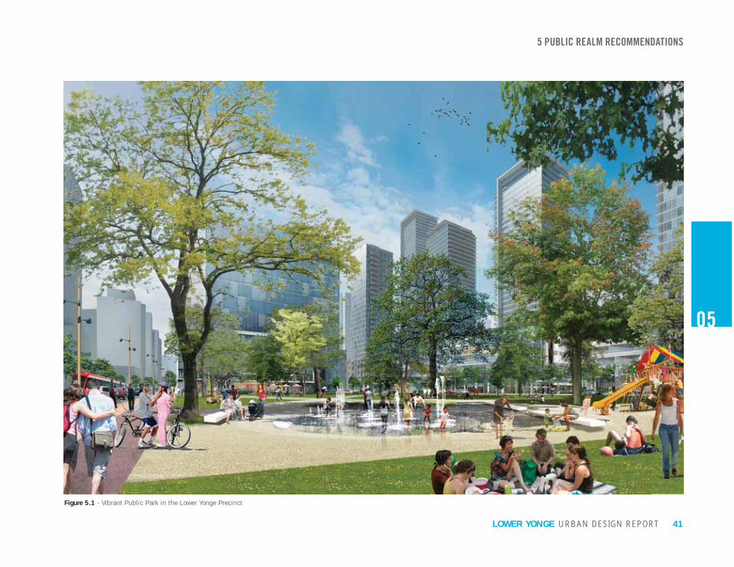
Figure 5.1 - Vibrant Public Park in the Lower Yonge Precinct

42 URBAN DESIGN REPORTLOWER YONGE
5.2 STREET NETWORKThe Lower Yonge Precinct street network described in this report was developed in coordination with Lower Yonge Transportation Master Plan Environmental Assessment (“TMP”). The resulting plan will establish a pedestrian friendly multi-modal street network that balances local and regional needs. Changes to the street network will facilitate the reconnection of the city to its waterfront, improve connectivity across the waterfront among emerging neighbourhoods, and establish appropriately sized blocks to support new mixed-use development. The following key recommendations of the TMP will contribute to ease of movement in and around the precinct:
1. and bicycle friendly neighbourhood main street from Yonge Street to Lower Jarvis Street.
2. Creation of a local “New Street” between Cooper Street and Lower Jarvis Street.
3. Insertion of two north-south pedestrian mid-block connections, one between Yonge Street and Freeland Street and one between Freeland Street and Cooper Street
Laneway.
4. Elimination of the “S” curve and regularization
intersection.
5. Shortening of the Gardiner Expressway eastbound Lower Jarvis Street off-ramp to land at Yonge Street and regularization of the Yonge Street and Lake Shore Blvd intersection.
6. Street and Yonge Street a two way street with improve pedestrian amenities.
7. Extension of Cooper Street across Lake Shore Blvd, under the Gardiner Expressway and through the rail corridor embankment to connect with Church Street to the north.
Figure 5.7 - Cooper Street ExtensionFigure 5.4 - Mid-block Connections
Figure 5.5 - Heritage Laneway
Figure 5.6 - Regularized Intersections
Figure 5.2 - Harbour Street Extension
Figure 5.3 - New Street between Cooper and Jarvis Street
5 PUBLIC REALM RECOMMENDATIONS
05
LAKE SHORE BLVD.
GARDINER EXPRESSWAY
RAIL CORRIDOR
LAKE SHORE BLVD.
GARDINER EXPRESSWAY
RAIL CORRIDOR
LAKE SHORE BLVD.
GARDINER EXPRESSWAY
RAIL CORRIDOR
LAKE SHORE BLVD.
GARDINER EXPRESSWAY
RAIL CORRIDOR
LAKE SHORE BLVD.
GARDINER EXPRESSWAY
RAIL CORRIDOR
RAIL CORRIDOR
LAKE SHORE BLVD.
GARDINER EXPRESSWAY

43URBAN DESIGN REPORTLOWER YONGE
Figure 5.8 - Street Network Plan
05
5 PUBLIC REALM RECOMMENDATIONS

44 URBAN DESIGN REPORTLOWER YONGE
A comprehensive network of public streets and pedestrian laneways will ensure the community is well connected and offer multiple convenient routes to, from, and through the precinct. Surrounding the precinct, the Gardiner/ Lake Shore corridor, Lower Jarvis Street and Queens Quay East, are each in the process of undergoing independent transformations. To the north, Gardiner/ Lake Shore corridor is currently being studied as part of a comprehensive environmental assessment that includes public realm objectives for improving its urban condition. To the east, Lower Jarvis Street will be widened in accordance with the East Bayfront Municipal Class EA. To the south, Queens Quay East is planned to be revitalized as per the East Bayfront Transit EA with a
grade-separated multi-use trail.
RECOMMENDATIONS:1. Fine-Grained Street Network Plan
should be established to extend a typically scaled city street pattern through the precinct.
permeability and contribute to good light conditions in the public realm and within adjacent development as per the Street Network Plan (See Figure 5.8).
2. Complete Streets All internal streets should be designed to be multi-modal and promote active transportation.
3. Improved Connections Streets from adjacent neighbourhoods should be extended through the precinct to achieve maximum integration with the surrounding city fabric and connections to surrounding waterfront communities and the downtown consistent with the Street Network Plan.
4. On-Street Parking On-street parking should be provided to
an additional buffer between the sidewalk and
5 PUBLIC REALM RECOMMENDATIONS
05
45URBAN DESIGN REPORTLOWER YONGE
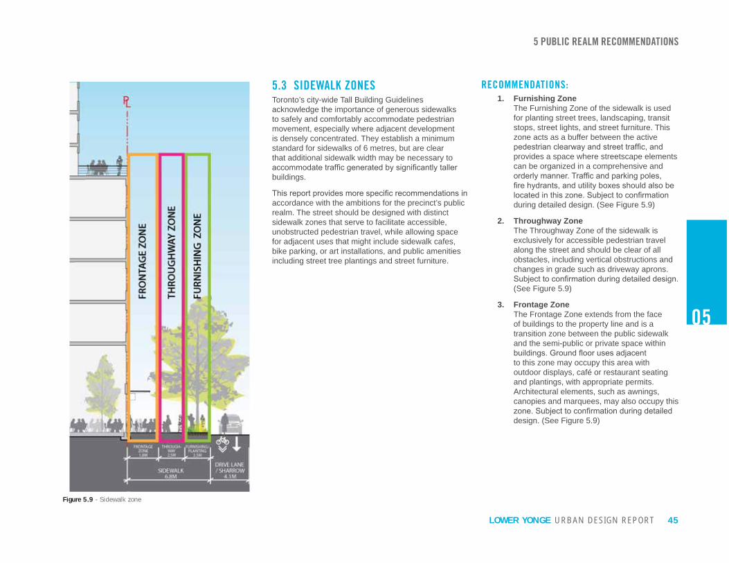
Figure 5.9 - Sidewalk zone
5.3 SIDEWALK ZONESToronto’s city-wide Tall Building Guidelines acknowledge the importance of generous sidewalks to safely and comfortably accommodate pedestrian movement, especially where adjacent development is densely concentrated. They establish a minimum standard for sidewalks of 6 metres, but are clear that additional sidewalk width may be necessary to
buildings.
accordance with the ambitions for the precinct’s public realm. The street should be designed with distinct sidewalk zones that serve to facilitate accessible, unobstructed pedestrian travel, while allowing space for adjacent uses that might include sidewalk cafes, bike parking, or art installations, and public amenities including street tree plantings and street furniture.
RECOMMENDATIONS:1. Furnishing Zone
The Furnishing Zone of the sidewalk is used for planting street trees, landscaping, transit stops, street lights, and street furniture. This zone acts as a buffer between the active
provides a space where streetscape elements can be organized in a comprehensive and
during detailed design. (See Figure 5.9)
2. Throughway Zone The Throughway Zone of the sidewalk is exclusively for accessible pedestrian travel along the street and should be clear of all obstacles, including vertical obstructions and changes in grade such as driveway aprons.
(See Figure 5.9)
3. Frontage Zone The Frontage Zone extends from the face of buildings to the property line and is a transition zone between the public sidewalk and the semi-public or private space within
to this zone may occupy this area with outdoor displays, café or restaurant seating and plantings, with appropriate permits. Architectural elements, such as awnings, canopies and marquees, may also occupy this
design. (See Figure 5.9)
05
5 PUBLIC REALM RECOMMENDATIONS

46 LOWER YONGE URBAN DESIGN REPORT
Figure 5.10 - Consistent Public Realm Design along Harbour Street
5.4 HARBOUR STREETThe study area of both this report and the TMP
Street extension within the precinct area.
an auto-oriented corridor that primarily serves
the relocation of the Gardiner Expressway York-Bay off-ramp to land at Lower Simcoe Street will
The associated reduction of ramp infrastructure allows
street better balancing regional and local needs of the
enhanced local access and be pedestrian and bike friendly.
contribute to its importance as the spine around which
as having a consistent public realm design from Lower Simcoe Street to Lower Jarvis Street with bicycle and pedestrian facilities as described in this report.
5 PUBLIC REALM RECOMMENDATIONS
05

47URBAN DESIGN REPORTLOWER YONGE
Figure 5.11 - Harbour Street Section between Yonge and Freeland Street
05
RECOMMENDATIONS:1. Consistent Character and Right-of-Way
Width
public realm character from Lower Jarvis Street to Lower Simcoe Street. The right-of-way width of 27 metres should be consistent
Street.
2. Alignment of Harbour Street
align at the centerline of the street. The
straight to Jarvis Street to enhance visual and physical connectivity within the precinct and with the neighbourhood to the west.
3. North Sidewalk
Street should be wider with enlarged frontage and furnishing zones to take advantage of the sunny north side of the street and to encourage active street life.
4. Curb-Cut Prohibition
interrupted with parking access and service driveways. Vehicle access to development blocks should be located on north-south local streets.
5 PUBLIC REALM RECOMMENDATIONS

48 LOWER YONGE
05
Figure 5.12 - Harbour Street Section between York and Bay Street Figure 5.13 - Harbour Street Section between Bay and Yonge Street
5 PUBLIC REALM RECOMMENDATIONS
HARBOUR STREET SECTIONS WEST OF YONGE STREET
URBAN DESIGN REPORT

49URBAN DESIGN REPORTLOWER YONGE
05
Figure 5.14 - Harbour Street Section between Freeland and Cooper Street Figure 5.15 - Harbour Street Section between Cooper and Jarvis Street
HARBOUR STREET SECTIONS EAST OF YONGE STREET
5 PUBLIC REALM RECOMMENDATIONS

50 URBAN DESIGN REPORTLOWER YONGE
05
Figure 5.16 - Harbour Street Concept Plan (continued overleaf)
5 PUBLIC REALM RECOMMENDATIONS
BAY
STR
EET
YOR
K S
TREET
GARDINER EXPRESSWAY LAKE SHORE BLVD.
HARBOUR STREET
QUEENS QUAY WEST

51URBAN DESIGN REPORTLOWER YONGE
05
1. Wide north sidewalk with frontage zone and pedestrian amenities
2. Generous south sidewalk with pedestrian amenities
3. Curb lanes as sharrows + parallel parking along north edge from Freeland to Jarvis Street
5 PUBLIC REALM RECOMMENDATIONS
YON
GE S
TREET
FREELA
ND
STR
EET
CO
OPER
STR
EET
LAKE SHORE BLVD.
GARDINER EXPRESSWAY
JAR
VIS S
TREET
QUEENS QUAY EAST
HARBOUR STREET
N
1
2
3

52 URBAN DESIGN REPORTLOWER YONGE
Figure 5.17 - North-South Street Section
5.5 NORTH-SOUTH STREETS The north-south streets are Freeland, Cooper and New Street. Cooper Street will eventually provide a needed connection north to the St Lawrence Neighbourhood by connecting to Church Street. Equally important, Cooper Street will connect the city to the north with Queens Quay East and the waterfront. Freeland Street and New Streets will be valuable local streets that break down the precinct into urban scaled blocks and provide alternative pedestrian and vehicular routes, residential and commercial addresses, servicing access points and regular views south to Queens Quay and the lake beyond. The recommendations below will be used to ensure the north-south streets are functional, while remaining attractive, pedestrian friendly connections.
RECOMMENDATIONS:1. Extended Sidewalk Width
All north-south streets should have a consistent right-of-way width of 20 metres, plus building setbacks on either side of the street for a minimum building face to building face dimension of 26 metres to accommodate an enhanced sidewalk environment for pedestrians and facilitate views south to Queens Quay and the lake.
2. Re-Align Cooper The southern half of Cooper Street between
should be aligned so that street alignment is consistent between Lake Shore and Queens Quay and aligns with the future Church Street extension.
5 PUBLIC REALM RECOMMENDATIONS
05

53URBAN DESIGN REPORTLOWER YONGE
05
5 PUBLIC REALM RECOMMENDATIONS
5.6 PUBLIC PARKLANDPublic parklands make Toronto a healthy and livable City. Investing in parkland is an integral part of city building and never has it been more essential than when concentrated urban living conditions are anticipated. The downtown and Central Waterfront contain the largest percentage of new residential development in all of the city’s growth areas. With increased residential growth, the need for parkland
demand from condominium residents for more parkland, more facilities for children, and more space for dogs.
The Lower Yonge Precinct is projected to have a future residential population between 6,000 and 10,000 people, who will generate their own demands for parkland and recreational amenities, with an additional demand from a projected 7,500 to 12,500 employees. Parks in the broader waterfront area, outside of Lower Yonge, serve either a destination or specialized function or are focused toward their own respective communities. There are limited options for parks and recreation uses for the Lower Yonge community within a reasonable walking distance that will address the neighbourhood park needs of future residents.
The precinct will need a park that is somewhere between a neighbourhood park and a community park to accommodate programming for local residents (multi-purpose lawn area, wading pools, splash pads, playgrounds, dog runs and picnic areas, etc.) and to
parks system. Neighbourhood parks average between 1.5 and 1.8 hectares. Community parks typically exceed 3 hectares. Smaller parcels of parkland would be inadequate in accommodating the necessary space for facilities and buffering for adjacent uses and circulation space.
A central location for such a park would be preferred, one that would be within a short walking distance from all surrounding residents. As well, a central park would reinforce the pattern of open spaces that has been established across the waterfront. Along Queens Quay, parks are typically located 200 - 250 metres apart. Figure 5.18 highlights the regularity of the rhythm established by these spaces. A new public park in the centre of the precinct would continue this pattern, while providing a central focal point and social heart for the area.

54 URBAN DESIGN REPORTLOWER YONGE
02
5 PUBLIC REALM RECOMMENDATIONS
Figure 5.18 - Rhythm of Open Spaces along the Waterfront

55URBAN DESIGN REPORTLOWER YONGE
02
RECOMMENDATIONS:1. Minimum Public Parkland Requirement
A minimum of 15 percent of land within the precinct not allocated for public streets should be dedicated for use as public parkland. A
in consideration of precedents established by prior precinct planning processes, and the higher levels of density anticipated within Lower Yonge.
2. Parkland Plan Parkland should be centrally located to provide a focal point for the community, be within a short walking distance of all residential and commercial uses within the precinct and be situated to be clearly
the Parks Plan (See Figure 5.19 and 5.20). Parkland should be located and organized to ensure it is perceived as public space and to discourage the privatization of any portion of it.
3. Consolidated Parkland At least one large consolidated block of parkland should be provided to facilitate the development of a large neighbourhood park that will be able to accommodate a maximum range of programming opportunities for families and in recognition of the role the park will play as a community park.
4. Sunlight Access Prioritization Parkland should be located to maximize access to existing amounts of sunlight and limit shadow impacts from anticipated development throughout the year, especially during the fall and winter months between September 21st and March 21st.
5 PUBLIC REALM RECOMMENDATIONS
5. Park Character Parkland should have a high percentage of soft landscape area to expand the variety of waterfront parks, support the park’s identity as a neighbourhood amenity, and provide
and promoting biodiversity.
6. Public Art Public art should be incorporated into parkland design as a functional element, an interpretive element or landmark.
Figure 5.19 - Public Park Location Option 1
Figure 5.20 - Public Park Location Option 2

56 URBAN DESIGN REPORTLOWER YONGE
5.7 PRIVATELY OWNED PUBLICLY ACCESSIBLE SPACES (POPS)Privately owned, publicly accessible spaces (“POPS”) are a key part of the city’s public realm network and provide open space in much needed locations. Like other parts of the public realm, POPS should be used to reinforce the structure of the city. For instance, they might mark an important intersection, provide context for a heritage building, or provide a mid-block connection that reveals an important view. POPS can take the form of courtyards, plazas, gardens, mid-block pedestrian connections or atriums. Provided and maintained by private developers, they supplement and complement public parks, but do not replace them.
Mid-block connections provide alternate and interesting routes for pedestrians and, if wide enough, for cyclists.
owned publicly accessible interior spaces, although portions of the network beneath rights-of-way or
is an interconnected network of indoor walkways and open spaces that have evolved in downtown Toronto. In 2012, City Planning oversaw the completion of a
associated with the study are available for use and provide guidance to improve safety, accessibility and
It is anticipated that City Council will soon adopt Privately-Owned Publicly Accessible Spaces Urban Design Guidelines. While the City has been securing POPS for years, the new guidelines will help to ensure that, going forward, these spaces are attractive, comfortable, safe and an asset to the public realm. The following guidelines echo and augment the City’s, and provide additional guidance relevant to the Lower Yonge context.
RECOMMENDATIONS:1. Provision of POPS
Each block in Lower Yonge should include POPS to enlarge the pedestrian network through the precinct. It is recommended that this contribution to the public realm be substantial and that a standard allocation be established.
2. POPS Plan A POPS Plan has been developed that
recommendations of this document (See Figure 5.21):
• Mid-block connections should connect to a public right-of-way on each end, and, when possible, align with water views to the south;
• Courtyards should connect to a public right-of-way or mid-block connection;
•
building, running east-west; and
• POPS spaces and be highly visible.
3. POPS as Extensions of the Public Realm
should be located at-grade with the public right-of-way.
4. Pedestrian Comfort in POPS Privately owned publicly accessible spaces should be located and designed to provide a comfortable environment for users with wind conditions that do not exceed those suitable for sitting and standing, access to sunlight, and lighting at night. Ample seating should be provided.
5 PUBLIC REALM RECOMMENDATIONS
5. Soft Landscaping POPS should be designed with a balance of hard and soft landscape to soften the appearance of the urban environment, and
cooling the urban environment, storm water
6. Motorized Vehicle Restriction POPS are pedestrian priority areas. Access by motorized vehicles should be restricted. Utilization as drop-off areas and access to on-site parking and loading should be prohibited.
7. POPS Animation Requirement When provided as interior spaces, POPS should be surrounded with active uses including food services, stores and restroom facilities.
8. Mid-block and LCBO Heritage Laneway Connections Minimum Width Outdoor mid-block connections should be a minimum of 10 metres wide.
05

57URBAN DESIGN REPORTLOWER YONGE
Figure 5.21 - Privately Owned Publicly Accessible Open Spaces (POPS) Plan
05
5 PUBLIC REALM RECOMMENDATIONS

58 URBAN DESIGN REPORTLOWER YONGE
Figure 5.24 - Civic Center Public Art
Figure 5.23 - Distillery District Public Art
Figure 5.22 - Flow Blue, Percent for Public Art Program Project
5.8 PUBLIC ARTWhile enhancing the visual appeal of streets and open spaces, public art can evoke or reinforce a sense of place. It is especially valuable when a neighbourhood is being reinvented, as with the Lower Yonge Precinct. Public art can be a landmark, a play structure, or a window onto an area’s context, referencing aspects that are not immediately apparent, be they social, natural, cultural, physical, political or historical. Opportunities for public art range from independent sculptures to art integrated into streetscape, landscape or a built form design.
Both the City of Toronto and Waterfront Toronto strongly support public art and seek to secure it as
public art opportunities and funding strategies for public art located either in publicly accessible visible areas within private lands or on publicly owned lands. Waterfront Toronto has been consistent in intent, but taken a different approach: pooled funds are used to
place all art within the public realm.
Development in the Lower Yonge Precinct will follow the City’s Percent for Public Art Program Guidelines, which recommend that a minimum of one percent
development be dedicated to public art. Each developer will decide whether their contribution will fund art on the publicly accessible portions of their property, be allocated for art within nearby public lands, or a combination of the two.
RECOMMENDATIONS:1. Provision of Public Art
Development projects within the Lower Yonge Precinct will participate in the City of Toronto’s Percent for Public Art Program.
2. Location of Public Art All public art will be located on publicly accessible portions of development parcels: within setbacks adjacent to the public sidewalk, within areas on-site subject to public access easement agreements, or, in the instance of funds allocated for art off-site, within publicly owned parks and open space in the Lower Yonge Precinct.
5 PUBLIC REALM RECOMMENDATIONS
05

59URBAN DESIGN REPORTLOWER YONGE
Figure 5.25 - Sherbourne Common Public Art
05
5 PUBLIC REALM RECOMMENDATIONS

URBAN DESIGN REPORTLOWER YONGE
02

026 BUILT FORM RECOMMENDATIONS62
64
66
68
70
72
74
76
78
80
6. 1 Introduction
6. 2 Base Buildings: Height and Articulation
6. 3 Base Buildings: Setbacks
6. 4 Base Buildings: Ground Floor Animation
6. 5 Base Buildings: Parking, Loading and Servicing
6. 6 Tall Buildings: Height
6. 7 Tall Buildings: Floor Plates
6. 8 Tall Buildings: Stepbacks
6. 9 Tall Buildings: Tower Area Ratio and Separation
6.10 Demonstration Plans

62 URBAN DESIGN REPORTLOWER YONGE
06
6.1 INTRODUCTION
within Lower Yonge based upon the principles and policies of the CWSP, precedents established during previous precinct planning exercises and a detailed consideration of the surrounding development context. They include:
• Built form will have a predominantly mid-rise character adjacent to streets to create an intimate, neighbourhood feel and achieve good sunlight conditions on public streets and open spaces;
• Building heights and density will transition downward from north to south;
• Towers will be broadly spaced in the tradition of prior precinct plans;
• Optimal micro-climatic conditions will be achieved within the public realm around buildings;
• Pedestrian sidewalks, where high volumes of
uses at grade.
These objectives are expanded upon in the detailed sections below.
6 BUILT FORM RECOMMENDATIONS

63URBAN DESIGN REPORTLOWER YONGE
2.5 Minute Walk
06
Figure 6.1 - View of Lower Yong Precinct from Ward’s Island Ferry Dock
6 BUILT FORM RECOMMENDATIONS

64 URBAN DESIGN REPORTLOWER YONGE
RECOMMENDATIONS:1. Maximum Base Building Height
Base buildings, other than those adjacent to Lake Shore Boulevard East, will not be higher than 26 metres, as shown on the Building
• Maximum Base Building Height – Lake Shore Boulevard East Base buildings adjacent to Lake Shore Boulevard East, with the exception of the block between Freeland and Cooper Streets, should not be higher than 38 metres (See Figure 6.2)
• Maximum Base Building Height –
Base buildings between Freeland and Cooper Streets to the south edge of
than 18 metres to preserve the integrity of the existing listed heritage building and east/west open space. (See Figure 6.2)
• Minimum Base Building Height Base buildings should not be lower than
listed heritage buildings at 55 Lake Shore Boulevard East, which reach a height of 18 metres. (See Figure 6.2)
6.2 BASE BUILDINGS: HEIGHT AND ARTICULATIONBase buildings will play a major role in establishing the precinct’s character and in determining the quality of pedestrian experience. Base buildings will be scaled to:
• Achieve the desired neighbourhood character and scale;
• Ensure that tall buildings do not overwhelm the pedestrian environment;
• Maintain access to sunlight and sky views for pedestrians and surrounding properties.
Most of the precinct will be built out with base buildings that achieve a maximum height of 26 metres, consistent with the dimension between building faces on local streets (20 metre rights-of-way plus 3 metre setbacks on either side of the street) and roughly consistent with the
levels of sunlight to reach neighbourhood streets and present a substantial but not overwhelming height adjacent to Queens Quay and Yonge Street, streets with wider rights-of-way.
Adjacent to Lake Shore Boulevard East, base building heights will be taller, 38 metres, in recognition of the wider adjacent rights-of-way and the 38 metre height limit within the surrounding context. An 18 metre height limit will apply to Lake Shore Boulevard East between Freeland and Cooper Streets to preserve the integrity of the listed heritage building on that block. Tower stepbacks will be used within the precinct to reinforce the prominence of the base buildings and mitigate the perception of height.
Finally, base buildings will be broken into smaller subdivisions with architectural articulation to create
the neighbourhood context, be conducive to further subdivision into retail bays and distinguish Lower Yonge from the Financial District where monolithic base buildings are more common.
6 BUILT FORM RECOMMENDATIONS
2. A minimum of 85% of base building facades should be constructed within 1 metre of the property line or required setback along all
street walls. Acceptable minor variations to the street wall may include recessed building entrances, recessed balconies, and privately-owned publicly accessible open spaces. Exceptions are not to include drop-off areas which should be contained within the site.
3. Facade Articulation The architecture of base buildings adjacent to a public right-of-way or public open space
grained precinct character. This articulation may be achieved with changes in materials, architectural detailing or vertical recesses.
4. Wind Mitigation Tower and base buildings should be massed and articulated to mitigate wind impacts on public rights-of-way and public and publicly accessible open spaces. Wind conditions at grade should be suitable for sitting and standing, with higher standards applying within parks and other places where people are expected to linger.
06

65URBAN DESIGN REPORTLOWER YONGE
Figure 6.2 - Base Building Concept
38M Height
38M Height
26M Height
18M Height
06
30M
30M
25M
6 BUILT FORM RECOMMENDATIONS

66 URBAN DESIGN REPORTLOWER YONGE
Figure 6.3 - Setback, an Extension of the Public Realm
6.3 BASE BUILDINGS: SETBACKSSetbacks will be established to broaden sidewalks and provide spaces that can be animated to enrich the public realm. Along Yonge Street wide setbacks will facilitate views south to the Yonge Street Slip, the future park along its eastern edge, and help to achieve an active streetscape on Yonge Street similar to that along the York Street Promenade.
Along both sides of north-south local streets within the precinct, development will be setback 3 metres and sidewalks widened to improve the quality of the pedestrian environment, expand views south towards Queens Quay and the lake, and allow more sunlight to reach the street by achieving a one-to-one ratio between street-width and building height.
RECOMMENDATIONS:1. Yonge Street Promenade
The setback along the east side of Yonge Street should be aligned with view corridors between Lake Shore Blvd and the waterfront. The view corridor results in a setback line that is straight from Lake Shore Blvd to Queens Quay East and varies in width due to the varying alignment of Yonge Street which results in a setback with between 10 to 17 metres. Existing structures/ conditions are exempt. (see Figure 6.4)
2. Queens Quay Setback Provisions to allow for the public realm to extend under the existing tower at Yonge and Queens Quay should be made to address substandard existing sidewalk widths. Additionally, the overall north sidewalk of Queens Quay is required to be a minimum of 6m unobstructed in width to comply with relevant City policies.
3. Freeland, Cooper and New Street Setbacks A 3 metre minimum setback should be established along both sides of Freeland, Cooper and New Streets. (See Figure 6.4)
4. Setback Design - Extensions of the Public Realm Setbacks are extensions of the public realm and should be designed as seamless continuations of the public sidewalk with consistent materials, grades and design elements. (See Figure 6.3)
5. Provision of Planting Area Setbacks that are wider than 4 metres should accommodate street tree planting, coordinated with that of the adjacent public sidewalk.
6. Protrusions into Setbacks Occupiable space, including balconies and vertical elements that block views, should not encroach into setbacks above grade. Balconies should be inset behind the street wall to preserve the prominence of the base building and views along the street.
6 BUILT FORM RECOMMENDATIONS
06

67URBAN DESIGN REPORTLOWER YONGE
Figure 6.4- Setback Plan
3m
3mQueens Quay
Setback
06
6 BUILT FORM RECOMMENDATIONS

68 URBAN DESIGN REPORTLOWER YONGE
06
6.4 BASE BUILDINGS: GROUND FLOOR ANIMATION To enhance public sidewalks as pedestrian priority
precinct should provide unobstructed views in from the public realm, numerous doorways to enter from the public realm and accommodate uses that spill out and enliven the public realm. In areas where this cannot happen, interruptions should be brief and intervening spaces should be well designed with high-quality materials and design elements that provide visual interest.
Streets within the precinct will each have their own distinct character. Queens Quay will be a broad, beautifully designed street with transit, public promenade and a dedicated bike trail. Retail and service providers along that street might be anticipated to cater to either workers from the buildings above or visitors to the waterfront, as well as area residents.
and more locally oriented, with retail outlets, cafes and services more in demand in this residential neighbourhood. Freeland and New Streets will be attractive pedestrian environments with sunny corners that have lots of potential, although parking and loading access points will be taken from these streets to limit interruptions to the pedestrian environment on higher order streets. Yonge Street, Cooper Street when it is extended, and Lower Jarvis Street will each play important regional roles in bringing people to the waterfront.
Figure 6.6 - Building ground floors provide access from the public realm
Figure 6.5 - Ground floor active uses enlivening the public realm
Active Uses
PublicRealm
RECOMMENDATIONS:1. Ground Floor Animation Plan
Active uses should be located along frontages
Zone (See Figure 6.7 and 6.8). At least 80%
this zone should be devoted to transparent windows and doors, or visually open to allow maximum visual interaction between sidewalk areas and interior spaces.
2. Promote Active Uses Active uses should be located on the ground
uses include, but are not limited to: stores, cafes and restaurants, commercial uses that service the local residents and workers; recreational and arts facilities; and building lobbies.
3. Concentrate Retail Uses on Higher Order Streets Retail uses should be concentrated along
Yonge Street and Jarvis Street and occupy a minimum of 60% of those frontages to support their individual roles: Queens Quay as a civic
Yonge and Jarvis as important connections to the waterfront.
4. Major North-South Street Buildings adjacent to Yonge, Cooper and Lower Jarvis Streets should be designed to accommodate retail uses. Parking and servicing access points should not be located
Street should be low enough to provide direct access from the adjacent sidewalk.
6 BUILT FORM RECOMMENDATIONS

69URBAN DESIGN REPORTLOWER YONGE
06
Figure 6.7 - Ground Floor Animation Plan with One Consolidated Park Option
Figure 6.8 - Ground Floor Animation Plan with Alternative Park Option
5. Articulate Fine Grained Retail Bays
into bays with maximum widths of 10 metres and correspond with the width of interior
streetscape at a comfortable human scale and a high degree of visual variety and interest when viewed from the adjacent sidewalk. Bays may be articulated by employing: a change in fenestration pattern; change in material; and a pronounced vertical recess or a protruding pier or column.
6. Maximum Retail Frontage Single retail tenants should not occupy more than 20 linear metres along any single street frontage to allow for a wider variety of retail along the street. Larger retail outlets and entertainment facilities, such as grocery stores and movie theaters, should be located above grade, below grade or deeper within the building behind a regular rhythm of small retailers at the street edge.
7. Maximize Ground Floor Permeability
the Ground Floor Animation Zone should have separate and unique entries from the adjacent street spaced, on average, every 7
be visually as well as physically accessible from the adjacent street. Windows should be transparent. Dark or mirrored glass should not be used.
8. Minimum Ground Floor Height
the publicly oriented nature of internal uses.
9. Maximum Lobby Frontage Building lobbies should not be more than 10 metres wide along the street frontage to preserve available frontage for more animated uses.
10. Grade Related Unit Prohibition Grade related residential uses are not recommended for the Lower Yonge Precinct.
6 BUILT FORM RECOMMENDATIONS

70 URBAN DESIGN REPORTLOWER YONGE
6.5 BASE BUILDINGS: PARKING, LOADING AND SERVICINGDevelopment within the Lower Yonge Precinct must have well organized parking, loading and servicing to permit the delivery of a high quality public realm. Successful organization locates these “back of house” activities away from the public realm and out of view. Parking will be located below grade, as will loading and servicing if at all possible. Access points for parking and loading will often be shared to reduce the number of interruptions to the public sidewalk. Vehicle access points will be well integrated into the design of building facades and may be concealed behind discrete garage
with high quality materials. Ventilation shafts and other site servicing equipment will be located away from the public sidewalk and, to the extent possible, incorporated into the building itself. Every reasonable effort should be made to reduce the adverse effects of “back of house” functions on the quality of the pedestrian environment.
RECOMMENDATIONS:1. Parking and Servicing Access Locations
Parking, loading and servicing access points should be located on the east and west sides of Freeland and the east and west sides of New Street, as indicated on the Parking, Loading and Servicing Plan (See Figure 6.12 and 6.13)
2. Service Access Prohibition on Harbour and Cooper Streets Service and parking access driveways should
in anticipation of their future development as higher order streets that will connect beyond the precinct and carry increased pedestrian
should be located on north-south local streets.
3. Shared Access Locations Buildings on the same block should share access points from the public street for parking, loading and servicing.
4. Limit the Number and Width of Access Locations Parking, loading and servicing access points should be kept to a minimum number and not dominate any particular facade. To the extent possible, access points should be limited to one per street frontage and parking, loading and servicing functions should share access points to reduce the number and width of vehicle routes across public sidewalks.
5. Driveway Widths Service driveways and parking access
wider than 6 metres. In case of one-way
metres.
6. Limit Disruptions to Active Frontages Loading and servicing areas at grade should be wrapped with active uses a minimum of 10 metres in depth to limit the disruption to the building’s activated frontage.
7. Design Access Locations Garage, loading and service entry areas should be designed to be integrated with the overall design of the facade. Service doorways should have attractive garage door panels. Loading entries should be designed to be resistant to damage from vehicle impacts and obscure views in during both daytime and nighttime (lit conditions).
6 BUILT FORM RECOMMENDATIONS
06

71URBAN DESIGN REPORTLOWER YONGE
Figure 6.9 - Building drop-offs incorporated into massing
Figure 6.10 - Parking entries integrated into architecture
Figure 6.11 - Loading and servicing frontages minimized
20m(typical setbackfrom corners)
20m(typical setbackfrom corners)
20m(typical setbackfrom corners)
20m(typical setbackfrom corners)
Figure 6.13 - Parking, Loading + Servicing Plan with Altenative Park Option
Figure 6.12 - Parking, Loading + Servicing Plan with One Consolidated Park Option
06
6 BUILT FORM RECOMMENDATIONS

72 URBAN DESIGN REPORTLOWER YONGE
6.6 TALL BUILDINGS: HEIGHT There are a number of planning and design consideration for towers given the substantial impact
considered in the wider waterfront context and be consistent with the principle of having tall buildings step down from north to the south. Stepping height down
transition from the super tall core of the Financial District to the height regime established along the waterfront including East Bayfront. This approach to east-west height is consistent with the prevailing pattern of the City’s skyline.
more than 150 metres which is consistent with the tallest buildings achieved between Yonge Street and Bay Street to the west, and within the East Bayfront precinct to the east. From this point, tower heights will descend to 120 metres, consistent with maximum tower heights immediately adjacent to the west side of Yonge Street, and, again echoed by some towers within the East Bayfront and the St Lawrence Neighbourhood to the north. Commercial towers along the north side of Queens Quay will be limited to 80 metres in height, lower than the existing Toronto Star Building and the residential tower at Pier 27, but higher than development adjacent to Queens Quay through the East Bayfront.
6 BUILT FORM RECOMMENDATIONS
06
RECOMMENDATIONS:1. Tower Height Zones
maximum height zones that step down from north to south. These zones should have height limits as follows:
• Taller Zones 150 metres in height on either side of major north-south streets (Yonge Street, Cooper Street and Lower Jarvis Street) within the precinct boundary. One tower permitted per zone. (See Figure 6.14)
• High-Rise Zone 120 metres height with exception of locating towers between the Taller Zones. (See Figure 6.14)
• Mid-Rise Zone 80 metres in height. (See Figure 6.14)
Figure 6.14 - Building Height Zones
High-rise
Mid-rise
Taller

73URBAN DESIGN REPORTLOWER YONGE
Figure 6.15 - Waterfront Skyline Analysis
06
6 BUILT FORM RECOMMENDATIONS

74 URBAN DESIGN REPORTLOWER YONGE
6.7 TALL BUILDINGS: FLOOR PLATES
with its height and placement, determine its impact on the surrounding streets, parks and open spaces. The Tall Building Design Guidelines, March 2013, like their
plates between 2,100 and 2,400 square metres. The
the precinct due to its proximity to transit.
RECOMMENDATIONS:1. Maximum Residential Floor Plates
Residential towers dimensions should not exceed the following:
• 750 square metres
• 32 metres
• Maximum tower diagonal dimension: 40 metres
2. Maximum Commercial Floor Plates Commercial towers dimensions should not exceed the following:
• 2,200 square metres
• 60 metres
• Maximum tower diagonal dimension: 70 metres
t onThetheir
he
t
Max. Floor Plate: 2,200 sq. meters
Max. Plan Length: 60 meters
Max. Diagonal: 70 meters
Max. Floor Plate: 750 sq. meters
Max. Plan Length: 32 meters
Max. Diagonal: 40 meters
Figure 6.16 - Commecial Tower Floor Plates + Massing Figure 6.17 - Residential Tower Floor Plates + Massing
6 BUILT FORM RECOMMENDATIONS
06
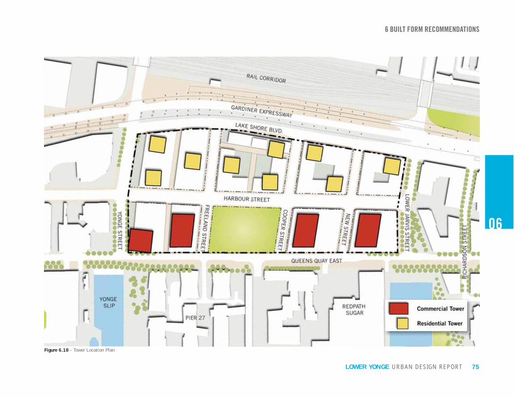
75URBAN DESIGN REPORTLOWER YONGE
Figure 6.18 - Tower Location Plan
06
6 BUILT FORM RECOMMENDATIONS

76 URBAN DESIGN REPORTLOWER YONGE
26 m
East BayfrontEast Bayfront
WITH 10mSTEPBACK
26 m
WITH 8mSTEPBACK
Figure 6.21 - Site Section with Stepbacks
Figure 6.20 - View of Freeland Street with 8m Stepback
Figure 6.19 - View of Queens Quay with 10m Stepback
6.8 TALL BUILDINGS: STEPBACKSTower stepbacks are intended to guarantee the prominence of the base building by ensuring that it becomes the precinct’s dominant built form and reducing the perception of towers from the street. Tower stepbacks also reinforce the comfortable one-to-one ratio between street width and building height, provide open sky views, mitigate wind impacts and direct access to sunlight, and on public streets.
Stepbacks are greater on north-south streets to broaden views towards the waterfront allowing for more sunlight to penetrate into the precinct. Tower stepbacks are also greater adjacent to Queens Quay to enhance the character of the waterfront’s important civic street and mitigate the substantial visual impact of the
East are more typical of those found elsewhere in the City, but broad enough to be effective in mitigating wind impacts.
6 BUILT FORM RECOMMENDATIONS
06
RECOMMENDATIONS:1. Tower Stepbacks Adjacent to Queens
Quay Towers adjacent to Queens Quay should stepback a minimum of 10 metres at a height no greater than 26 metres from the face of the building below. (See Figure 6.22)
2. Tower Stepbacks Adjacent to Harbour Street
stepback a minimum of 5 metres at a height no greater than 26 metres from the face of the building below. (See Figure 6.22)
3. Tower Stepbacks Adjacent to Lake Shore Boulevard East Towers adjacent to Lake Shore Boulevard East, where permitted, should stepback a minimum of 5 metres at a height no greater than 38 metres from the face of the building below. (See Figure 6.22)
4. Tower Stepbacks Adjacent to North-South Streets Towers adjacent to Yonge, Freeland, Cooper, New and Jarvis Streets should stepback a minimum of 8 metres at a height no greater than the permitted height of the base building, from the face of the building below. (See Figure 6.22)

77URBAN DESIGN REPORTLOWER YONGE
Figure 6.22 - Stepback Plan
5m
5m
5m
10m
8m
8m 06
6 BUILT FORM RECOMMENDATIONS

78 URBAN DESIGN REPORTLOWER YONGE
6.9 TALL BUILDINGS: TOWER AREA RATIO AND SEPARATIONThe “Tower Area Ratio” (TAR) measures the
the total block area (development parcel). The TAR is an implementation tool based on the City’s Tall Building Design Guidelines recommendation that as the height of tall building increases, the separating distance between towers should also increase. The City’s Tall Building Design Guidelines provides guidance on the intent to increase distances but does not prescribe a measure.
A study was undertaken to determine the target percentages to be used for the Lower Yonge Precinct. It was found that residential developments described as creating a “wall of condos” had a TAR or 27% or greater. These residential developments were characterized by tightly spaced towers that overlap each other when viewed from adjacent streets, blocking long views and appearing as a consolidated mass of development. Residential development characterized by open sky views and access to sunlight were typically found to have a TAR of below 20%. For commercial developments it was found that a maximum TAR of 35% was appropriate for buildings less than 80m in height.
Minimum tower separation distances limit negative impacts on the public realm, while also protecting neighbouring towers and properties from loss of sunlight and views. The City’s Tall Building Design Guidelines anticipate that large sites will require
between towers in consideration of a broad range
waterfront’s public objectives, the recommendation is that separation distances be established in excess of the minimum prescribed in order to address the prevailing concern of creating a “wall of condos” along the waterfront.
6 BUILT FORM RECOMMENDATIONS
06
Figure 6.25 - Tower Area Ratio Concept DiagramFigure 6.23 - Tower Separation Distance with Building Height (Tall Building Design Guidelines 3.2.3)
Figure 6.24 - 20% and 35% of Tower Area Ratio
RECOMMENDATIONS:1. TAR North of Harbour Street
For towers maximum of 20% of the total site area may project above the base building.
2. TAR South of Harbour Street
maximum of 35% of the total site area may project above the base building.
3. Minimum Separation Distances Towers should be separated by 30m or if more than 80m high, a length consistent with the longest edge of the tower, whichever is greater.
TAR = 35% of Development Block
TAR = 20% of Development Block
TALL BUILDING DESIGN GUIDELINES 3.2.3
are proposed, provide greater setbacks and separation distances proportionate to increases in building size and height.

79URBAN DESIGN REPORTLOWER YONGE
Figure 6.26 - Tower Separation Plan
06
6 BUILT FORM RECOMMENDATIONS

80 URBAN DESIGN REPORTLOWER YONGE
6.10 DEMONSTRATION PLANSThe urban design principles and recommendations were tested for three development scenarios. Figures 6.27 through 6.29 illustrate three different mix of land uses, park location and built form massing that all achieve the overall urban design vision for the Lower Yonge Precinct.
The mix of uses illustrated in these scenarios are:
Development Scenario 1 - Residential towers
park area;
Development Scenario 2 - Mix of residential and
one central park area;
Development Scenario 3 - Mix of residential and
two park parcels along Cooper Street.
6 BUILT FORM RECOMMENDATIONS
06
Figure 6.29 - Development Scenario 3
Figure 6.27 - Development Scenario 1
Figure 6.28 - Development Scenario 2

81URBAN DESIGN REPORTLOWER YONGE
06
Figure 6.30 - Urban Design Vision for the Lower Yonge Precinct
6 BUILT FORM RECOMMENDATIONS


