urban environmental planning - scholarlink researchjetems.scholarlinkresearch.com/articles/urban...
TRANSCRIPT

Journal of Emerging Trends in Economics and Management Sciences (JETEMS) 5(3):351-363 (ISSN: 2141-7016)
351
Urban Environmental Planning and Development Control of Medium Sized Towns in Kenya. A Case of Eldoret Municipality
Job K. Ngetich, Grephas P. Opata and Leonard S. Mulongo
School of Environmental Studies, University of Eldoret,
P.O BOX 1125-30100, Eldoret, Kenya.
Corresponding Author: Job K. Ngetich _______________________________________________________________________________________
Abstract
Kenya is urbanizing and is projected to be a predominantly urban country by 2033. Currently, about 30 percent
of the population lives in urban areas. The share of the urban population is set to rise 37 percent by 2020, and in
2033, Kenya will reach an important milestone, when most of its population will live in urban areas. Eldoret is
one of the Kenya’s Medium sized towns in Kenya, which is experiencing rapid rate of urban growth. It has a
population of 289,380 people and by 2030 it will be home to 584,782 people. This rapid urbanization will
therefore need to be guided by effective urban development control instruments and practices important for
sustainable urban livelihoods. The paper identifies and documents Urban development control instruments and
practices, and determines their impacts on the urban environment. Urban development control in Eldoret is
informed by both statutory and non-statutory instruments with Urban Areas and Cities Act 2011 being the
principal instrument. The spatial pattern of Eldoret Municipality is closely knit with the type of plans which
have been implemented over the years including, Physical development plans, Part development plans, Structure
plans, Advisory plans, zoning plans and Subdivision plans. It is estimated that on average between 706 and 1000
building structures are generated per year such that by 2030, over 20,000 buildings will be expected to be built
leading to land coverage of about 4km2 and its attendant environmental problems. The paper gives a framework
for addressing environmental problems associated with urban development control in Eldoret Municipality.
__________________________________________________________________________________________
Keywords: urban development, environmental planning, development control, physical development plans
INTRODUCTION
Kenya is urbanizing and is projected to be a
predominantly urban country by 2033. Twenty years
ago Kenya’s urbanization level was only 18%. Since
then, Kenya’s urban population has been rising
rapidly with an urbanization rate of 4%. Currently,
about 30 percent of the population lives in urban
areas. The share of the urban population is set to rise
to 37 percent by 2020, and in 2033 Kenya will reach
an important milestone, when most of its population
will live in urban areas. Every year more than
250,000 Kenyans are moving to cities and formerly
rural areas are becoming increasingly urban (World
Bank, 2014). Figure 1.1 shows urbanization trends
from the global and regional contexts.
Figure 1.1: Urbanisation Trends
Source; World Bank, 2014
Eldoret town is one of the towns in Kenya which is
experiencing rapid growth. Eldoret town is currently
inhabited by over 300,000 people. It is projected that
the town will be home to 584,782 people in 2030.
This rapid urbanization will therefore need to be
guided by effective urban development control
instruments and practices.
STATEMENT OF THE PROBLEM
Urbanization process is unstoppable, irreversible, and
is taking place largely in developing world. In 2003
the global urban population was estimated to be at 3
billion, while half of the world population or 3.3
billion people lived in urban areas in 2008. This
number is expected to rise to 5 billion by 2030, and
80% of these urban dwellers will live in towns and
cities of the developing world (Leautier, 2006;
ISOCARP, 2010). Africa, though currently lagging
behind other regions, in terms of numbers will be
home to a staggering 1.2 billion urban dwellers by
2050.The situation in Kenya is a reflection of the
global trend. It is estimated that more than 34% of
Kenya’s population lives in urban areas and by 2030
this number is projected to reach 63%.It is estimated
that 71% of the urban population live in slums.In the
case of Eldoret town, its population has been
increasing rapidly from 8,193 in 1948, to 197, 144, in
1999, and 289,380 in 2009. It is projected that at the
Journal of Emerging Trends in Economics and Management Sciences (JETEMS) 5(3):351-363
© Scholarlink Research Institute Journals, 2014 (ISSN: 2141-7024)
jetems.scholarlinkresearch.org

Journal of Emerging Trends in Economics and Management Sciences (JETEMS) 5(3):351-363 (ISSN: 2141-7016)
352
growth rate of 3.35% that by the year 2030, Eldoret
town will be home to over 584,782 people, and hence
the need for effective instruments of urban
development control.
Urbanization in Kenya is occurring in a disorderly
fashion as there is no planned framework defining the
desirable national urban structure and form to be
promoted. Urban areas are therefore sprouting
haphazardly on the national landscape. At the local
level, urban areas are expanding spontaneously
without regulation and guidance. What is happening
in the country’s urban sector can be summarized as
chaotic or rogue urbanization; the kind of
urbanization that can only accentuate under-
development, rather than promote development
(AAK, 2011).
Urban form directly impacts the habitat, ecosystems
and water quality, leading to loss of many
endangered species of both flora and fauna. Urban
form also gives rise to the emission of greenhouse
gases that are driving adverse climate change,
affecting water quality and impacting negatively on
human health. In Kenya, environmental problems
continue to be experienced despite the existence of a
plethora of laws and regulations as evidenced by
massive developments being constructed on
environmentally sensitive and fragile areas such as
wetlands, riparian reserves and hill tops. Blockage of
natural water drains on the urban areas by authorized
developments and paved surfaces have been known
to facilitate flooding and increase surface runoff. This
underscores the need to develop practices that reduce
negative environmental impacts in the urban areas
(Muigai, 1995; AAK, 2011).
OBJECTIVES OF THE STUDY The study was intended to establish the effectiveness
of urban development control instruments and
practices as they are implemented in Eldoret
Municipality and their environmental implications.
The specific objectives include:-
a) To identify and, document the existing urban
development control instruments and practices in
Eldoret Municipality
b) To establish the spatial development trends of
urban development and their implications on the
urban environment
c) To formulate a framework for addressing
environmental problems of Urban development
control
THE STUDY AREA
The study area is Eldoret Municipality in Kenya
which is located at a distance of 300 Km to the North
Western part of Kenya, from Nairobi. Figure 1.2
shows the location of Eldoret town in Kenya.
Figure 1.2: Location of Eldoret Town in the Map of
Kenya
Source: Republic of Kenya, 2007
RESEARCH METHODOLOGY
The data was collected through document analysis
and field survey of selected four urban
neighbourhoods zones of Elgon View (Low Density
Residential), Kimumu (Medium Density Residential),
Langas (High Density Residential) and Maili Nne
(Peri-urban).Interview schedules were used to garner
data from urban development control institutions of;
Physical Planning, Public Health and Lands
Departments, Kenya Airport Authority and the Kenya
Urban Roads Authority. The statistics on the number
of development applications such as building plans
and spatial plans were obtained through document
analysis.
RESULTS AND DISCUSSION
Legislative Framework of Urban Environmental
Planning and Development Control
Kenya like many other countries has for a long time
used the European- British planning system which
consists of the vestiges of legislation of 1947, 1953
and 1959,where the local planning authority must
grant permission before any development is carried
out. Following the promulgation of the new
constitution of Kenya in 2010,the European oriented
system of planning which was characterized by
existence of institutions such as the ones for the
Mayors, Chairmen and Town/County clerks of the
Municipalities and Counties, has been replaced with
Americo-centric system of planning and
Administration. Kenya operates under a devolved
framework with 47 semi-autonomous Counties under
the leadership of the Governors and Senators. The
administrative structure is still in nascent stage. The
Town/or Municipal Board and City Management
Boards are to run the cities with the Town Manager
as the Chief Executive. Table 1.1 provides a
summary of instruments and tools used for Urban
development control system in Kenya.

Journal of Emerging Trends in Economics and Management Sciences (JETEMS) 5(3):351-363 (ISSN: 2141-7016)
353
Table 1.1 Urban Environmental Development
Control Tools Development control
Institution/ Instrument
Urban development control
tools
Stage and
process
Physical Planning
PPA, Cap 286
PPA 1: Comments sheet
Application for development
permission
Application/Su
bmission
PPA2: Notification /Approval
Deferment/ Refusal of
Development permission
Approval
PPA 5:Certificate of
Compliance
Completion of
building
PPA 8,PPA 9: Appeal against
refusal to approve
Approval stage
National
Environmental
Management Authority
(NEMA) EMCA, 1999
EIA project Report Application
EIA License Approval
EIA/ Audit Operation
Stop order Operation
Public participation Continuous
Urban Areas and Cities
Act 2011, Eldoret
Municipality By laws
2008
PPA 1: Application for
development permission
Application/Su
bmission
Application for approval of
plans Form, Building by laws
1968
Application/Su
bmission
Circulation Form Circulation/Ap
proval
PPA 2: Notification of
approval, refusal to approval
Approval
Job card/Building Inspection
Card
Construction
Occupation Certificate Completion
stage
Public Health Act cap
242
Application /site inspection
Form
Application
Occupation certificate Completion
Source: Author’s Document Analysis, 2013
Development Control Plans and Development
Trends in Eldoret Municipality
In Kenya plan making process is vested in the office
of the Director of Physical Planning while the County
Governments are responsible for plan execution. This
principle of separation of roles has not augured well
for sustainable urban development as the preparatory
authority is not the implementing authority. This has
resulted in well designed plans being ignored by the
implementing authorities. Ndegwa (2001) suggests
that for the implementing authorities to put plans
effectively into practice, they should be required to
table plans for ownership and adoption in their
meetings. The plans which have contributed to the
spatial ordering of Eldoret town are mainly the Local
physical development plans which consist of
Advisory plans, Zoning plans, Structure plans, Part
Development Plans (PDPs) and subdivision plans.
Local Physical Development Plans (LPDP) provide
detail basis for land use policy of the entire town or
part thereof. The Eldoret Town Physical
Development plan no. ELD 17/81/13 of 1981 is still
being used as a legitimate development control tool
and it covers the CBD and its immediate
environments. It was prepared under the Town
planning Act Cap 134 which is as good as prepared
under PPA Cap 286.Figure 1.3 shows the proposed
Eldoret Town Physical Development plan 2008-2030.
The major proposals and recommendations include;
increased housing supply, slum upgrading, delivery
of community facilities and infrastructure, efficient
transportation planning, environmental protection and
heritage conservation and economic investment
strategy (Kenya, 2010).Figures 1.4-1.9 shows various
spatial plans that have influenced the development
patterns of Eldoret town.
Source; Kenya (2010)
Figure 1.3: Eldoret Town Local Physical Development Plan, 2008-2030

Journal of Emerging Trends in Economics and Management Sciences (JETEMS) 5(3):351-363 (ISSN: 2141-7016)
354
Source: Field Data Analysis, 2013
Figure 1.4 Existing Land Uses in Eldoret Town
Source: CPPO 2013
Figure 1.5: Eldoret Town Central Business District and its Environs

Journal of Emerging Trends in Economics and Management Sciences (JETEMS) 5(3):351-363 (ISSN: 2141-7016)
355
Source: CPPO, 2013
Figure 1.6 Eldoret Municipality’s Moi Annex Section, Zoning Plan
Source: CPPO, 2013
Figure 1.7: Eldoret Municipality’s, Langas Informal Settlement Development Plan

Journal of Emerging Trends in Economics and Management Sciences (JETEMS) 5(3):351-363 (ISSN: 2141-7016)
356
Source: CPPO, 2013
Figure 1.8 Eldoret Municipality’s, Kimumu Section Structure Plan
Source: CPPO, 2013
Figure 1.9 Eldoret Municipality’s, Maili Nne, Block 20, 21 and 23, Section Zoning Plan

Journal of Emerging Trends in Economics and Management Sciences (JETEMS) 5(3):351-363 (ISSN: 2141-7016)
357
Components of Urban Development Control
The elements of urban development control include
Part Development plans, Sub divisions, change of
user, extension of user, extension of lease, and the
building plans. These elements of urban development
are implemented leading to the way the towns
spatially get organized. In the process of their
actualization, the urban environment could seriously
be placed at risk. An examination of these urban
development control elements is important in the
establishment of the actual status of development
control in Eldoret Town.
Part Development Plans
Part development plans (PDP’s) are plans which are
prepared on the basis of an approved Physical
Development plan. It indicates precise areas
identified for immediate use and for alienation. It is
this instrument that has been abused or used in the
past to identify and allocate plots reserved for public
utilities, riparian reserves and other environmentally
sensitive areas, for private use. Figure 1.10 depicts
PDP’s prepared from 1990-2010.
Source; Document Analysis, 2013
Figure 1.10, Part Development Plans and Sub-
division Plans Prepared from 1990-2010
From the above figure; it should be noted that there
were two legal regimes which were used to prepare
PDP’s, from 1990 to 1998 when the town planning
Act Cap 134 was in force while PPA became
operational fully from 1999. Under the old legal
regime, there were many PDP’s which were prepared
compared to the few PDPs prepared from 1999 to
2010. In 1995 a total of 320 PDPs were prepared for
plot allocation which was the highest number to be
prepared in Eldoret Municipality in 20 year period.
The explanation given is that this was the peak period
when plots were being allocated like a hot cake after
the introduction of multi-party politics in Kenya. The
plot allocation led to the abuse of urban development
instruments resulting in conversion of public utilities
and fragile environments for private interest. From
1999 to 2010 when PPA was in force, preparation of
PDPs has been on a declining trend. This is attributed
to the stringent procedures introduced under PPA
involving advertisement and Gazettement of PDP’s
prior to approval and subsequent allocation that has
bared many land speculators from looking for land as
the process elicits objections. Secondly the embargo
placed on land transactions following the change of
political of guard and regime from KANU to NARC
in 2002, stopped the preparation of PDPs and other
associated land transactions. The demolition of
building structures which had been erected earlier on
road reserves and on land reserved for public utilities
such as schools, in an effort to correct the past
mistakes done, controlled the appetite for land by
land speculators and hence the reduction in the
number of land transactions. Land reforms have also
taken place since 2002 and which culminated in the
adoption of the New Constitution of Kenya 2010 and
subsequent enactment of Land laws including,
National Land Commission Act 2012, Land
Act,2012, Land Registration Act 2012 and the
Environment and Land Court, all of which have
urban development control jurisdictions. The Land
laws provide a framework on how public land is to be
acquired and thereby determining when a PDP is to
be prepared. The few PDP’s prepared from 2002 to
2008 were mainly designed for public institutions
like schools with proper government approval.
Sub-Division Plans
Land subdivision is a development control tool. In a
place where there is no master plan to guide layout
development of a town, a subdivision plan is used as
a premise for decision making. A subdivision plan is
used to actualize proposal of LPDP, and specifies
zoning density of an area. Figure 1.10 shows trends
in land subdivisions in Eldoret Municipality from
1990-2010.The subdivision plans prepared during
the twenty year period depicts a trend that has been
fluctuating over time. The trend of land subdivisions
is not realistic as the town has been recording rapid
growth at the estimated rate of 8% per year and hence
land subdivisions and related development should
have been on the upward trend. This shows that land
subdivision has not been an effective development
control tool. From the perspective of the land
subdivision, Figure 1.11 Shows the various elements
of urban development control as processed from 2005
to 2011 period.

Journal of Emerging Trends in Economics and Management Sciences (JETEMS) 5(3):351-363 (ISSN: 2141-7016)
358
Figure 1.11.Urban Development Trends in Eldoret
Municipality
Source; Document Analysis, 2013
The two Figures 1.10 and 1.11 when compared,
indicates that the number of land subdivisions
processed according to the years, are not the same for
EMC as well as in Physical Planning Department, a
clear indication that that the two institutions are not
working in harmony. The land subdivision mutations
are registered and the Registered Index Maps (RIM)
are amended without reference to EMC and the
Physical planner. These situations facilitate
development of shanties and associated negative
environmental problems. Musyoka (2004) avers that
informal settlement which spring up as a result of
informal subdivisions ends up being regularized or
formalized by Planning Authorities. The PPA has no
mechanism for dealing with developed areas as
development permission is only applicable to the
proposed development on vacant plots. In other
jurisdictions such as the United Kingdom, certain
developments are except under General Development
Orders (GDO), Use Class Orders and Simplified
planning zones. A modified planning permission may
be sought by the applicant with a developed property.
Change of User, Extension of User and Extension
of Lease
The change of user, extension of user and extension
of lease are interrelated elements of development
control which contribute towards making urban areas
to be what they are. They can be used to monitor land
use change in the urban setting. Change of user
entails substituting the existing function of the plot
for another different user while extension of user
involves introducing another different user to share
the same space in the plot. In the case of extension of
lease, it means renewal of lease to reflect an extra
term of ownership. Figure 1.11shows trends in
change of user, extension of user and lease renewal in
EMC from 2005 to 2011.
On average, the tables indicate that application of
change of user, extension of user and extension of
leases elements of development control are on the
increasing fashion, a clear indication of rapid urban
growth and its concomitant environmental effects.
Analysis of Building Plans
Buildings or structures contribute to negative
environmental impacts more than other development
control elements of change of user, extension of user,
extension of lease, land subdivisions and PDP’s.
Buildings are associated with the construction
industry which is a major contributor to the
environmental crisis through resource depletion,
energy consumption, air pollution and generation of
waste (UN Habitat, 1999). The physical growth of a
town is measured in terms of the structures which
have been built in the urban area. Figure 1.12 shows
the trend in submission of plans in EMC from 2005-
2011.
Source; Document Analysis, 2013
Figure 1.12 Approved Building Plans in 2005-2011
It is clear from the Figure that there was a drastic
decline in the number of building plans processed in
EMC from 619 numbers of applications in 2007 to
423 in 2008. This represented a decline of 32%. The
decline is attributed to post election violence of 2007
and 2008 which erupted spontaneously following the
disputed election between Party of National Unity
(PNU) and Orange Democratic Movement (ODM).
The impact of post election violence was that the
investors shied away from investing in Eldoret town
for some time. There was again rapid increase in the
number of building plans processed by EMC in 2010
to 2011, from 642 to 1134 building plans
respectively, a clear indication of restored investor
confidence and climate in Eldoret Municipality.
Projection of Building Plans and Plot Coverages
The analysis of the rate at which building structures
sprung up from 2005 to 2011 revealed that a total of
4941 building plans had been processed by 2011. On
Number Of Extension
Of Lease

Journal of Emerging Trends in Economics and Management Sciences (JETEMS) 5(3):351-363 (ISSN: 2141-7016)
359
average it is estimated that the ground coverage
occupied by a building in a plot was 50% or
equivalent to about 200m2. It therefore implies that
over 988,200m2 of land in the entire EMC had been
built up or covered by the year 2010. This translates
into total land coverage of about 1 Km2 in EMC,
leading to numerous environmental problems. Figure
1.13 shows extrapolation of buildings in EMC by
2010.
Source; Based on Document Analysis
Figure 1.13 Spatial distribution of buildings constructed in EMC from 2005- 2010
Projected Developments in Eldoret Town by 2030
It is projected that by the year 2030 the urban
population in Kenya is expected to reach a target of
38.2 million (Kenya Vision, 2030).Eldoret town is
expected to make a significant contribution in
increasing the numbers of urban population in Kenya
as its growth is considered to be one of the highest.
This means that the town is going to attract a lot of
developments as Kenya Vision 2030, which is a long
term development blue print is being actualized. The
vision 2030 aims at making Kenya to be a globally
competitive and prosperous country with a high
quality of life by 2030. It aims to transform Kenya
into “a newly industrializing, middle-income country
providing a high quality of life to all its citizens in a
clean and secure environment.” (Kenya Vision,
2030). This underscores the need to devise effective
urban development control tools for sustainable urban
livelihoods that will make the country to achieve the
Vision by the year 2030. Based on the past scenario
analysis, it is projected that by 2030, Eldoret town is
expected to induce urban developments in form of
buildings up to over 20,000 buildings of various land
uses including residential, commercial, industrial,
educational public purposes, public utilities and
transportation. The developments of Eldoret is to be
accentuated by the implementation of devolved
government structure involving decentralization of
resources to the County government of Uasin
Gishu,and more so to Eldoret town.
Source: Projected from Field Data, 2013
Figure 1.14 Extrapolated Spatial Distribution of
Building Developments in EMC By 2030
Journal of Emerging Trends in Economics and Management Sciences (JETEMS) 5(3):351-363 (ISSN: 2141-7016)
360
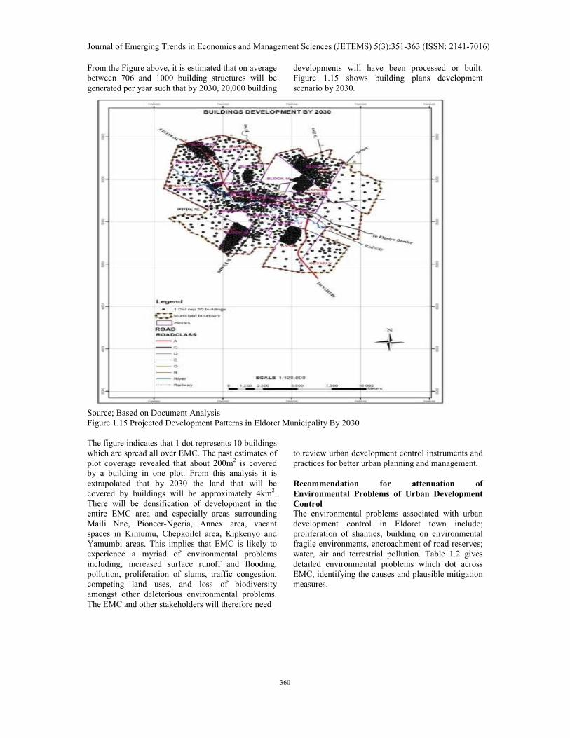
From the Figure above, it is estimated that on average
between 706 and 1000 building structures will be
generated per year such that by 2030, 20,000 building
developments will have been processed or built.
Figure 1.15 shows building plans development
scenario by 2030.
Source; Based on Document Analysis
Figure 1.15 Projected Development Patterns in Eldoret Municipality By 2030
The figure indicates that 1 dot represents 10 buildings
which are spread all over EMC. The past estimates of
plot coverage revealed that about 200m2 is covered
by a building in one plot. From this analysis it is
extrapolated that by 2030 the land that will be
covered by buildings will be approximately 4km2.
There will be densification of development in the
entire EMC area and especially areas surrounding
Maili Nne, Pioneer-Ngeria, Annex area, vacant
spaces in Kimumu, Chepkoilel area, Kipkenyo and
Yamumbi areas. This implies that EMC is likely to
experience a myriad of environmental problems
including; increased surface runoff and flooding,
pollution, proliferation of slums, traffic congestion,
competing land uses, and loss of biodiversity
amongst other deleterious environmental problems.
The EMC and other stakeholders will therefore need
to review urban development control instruments and
practices for better urban planning and management.
Recommendation for attenuation of
Environmental Problems of Urban Development
Control
The environmental problems associated with urban
development control in Eldoret town include;
proliferation of shanties, building on environmental
fragile environments, encroachment of road reserves;
water, air and terrestrial pollution. Table 1.2 gives
detailed environmental problems which dot across
EMC, identifying the causes and plausible mitigation
measures.

Journal of Emerging Trends in Economics and Management Sciences (JETEMS) 5(3):351-363 (ISSN: 2141-7016)
361
Table 1.2 Environmental problems of Urban Development Control and Mitigation Measures Neighbourhood/
Urban zone
Environmental Issues/
Problems
Causes Mitigation measures
Maili Nne, Block
20,21,23
Proliferation of Slums e.g.
Bondeni, Shirika, Baringo,
Kingongo, Keroka, Bondeni, Emkoi, Umoja
-Uncontrolled land
subdivision and
development of poor structures
-enforcement of planning standards
-control sub-division
-slum upgrading -provision of sewered sanitation
-increase surveillance
Water pollution of River
Sosiani
-farming along river Sosiani
-direct discharge of wastes
-development along the
rivers
-washing of vehicles
-enforcement of EMCA
-cleaning of river Sosiani
-maintenance of 30m riparian reserve
-tree planting along river Sosiani
-provision of sanitary infrastructure
Lack of public utilities such
as schools, playgrounds and
green areas
-population pressure
-non-provision of public
utilities
-selling of 4% of
surrendered land by
previous owners and brokers
-acquisition of land for public utilities
-repossession of grabbed land
-enforcement of planning standards
Encroachment of agricultural land Milimani hill-Kiplombe
ridge
-settlement expansion e.g.IVC church area
quarrying
-creation of roads
-enforcement of EMCA -Regulation of quarrying
-zoning of escarpment as a conservation area and tree
planting -rehabilitation of quarries
Flooding/surface water run-
off
-increased construction
activities -de-vegetation
-farming activities
-blocked drains -building along streams and
natural water drains
-control of developments
-protection of natural water drains -unblocking of drains
-provision of sewered sanitation
Quarrying activities, Sirikwa quarry pits
-causes cracks in buildings -demand for building
materials
-rehabilitation of disused quarry -regulation of quarry under cap 306 of Mining Act
-Enforcement of EMCA
Blocked roads and poor
accessibility
-Construction of building on
road reserves
-narrow roads
-opening of roads
-grading of roads
-removal of structures on roads
Parking of Lorries along
A104, Eldoret –Webuye road
-location of Kenya pipeline
company
-lack of parking spaces
-location of Petrol Service
Stations
-provision of parking facilities
-restriction of lorries to Maili Nne Lorry park
Terrestrial pollution -indiscriminate disposal of wastes including polythene
papers
-washing of vehicles along streams
-leachate from pipeline
-proper disposal of wastes -provide wash bays
-enforce NEMA regulations
Land use conflicts -conflicts of roads, land ownership, change of user
from e.g. residential to
religious user, bars and churches
-use of Municipal physical planning liaison committees,and Environment and land Court Act,2011
-enforcement of zoning regulations
Air pollution -Lorries along A104
-Dust pollution during dry season
-smoke from Raiply
-enforce EMCA regulations, on mitigation measures
Loss of biodiversity -settlement of escarpment
-quarrying activities
-cutting of trees by KPLC
for power supply
-tree planting
-encourage environment friendly designs
-enforcement of EMCA
LANGAS Overcrowding -non- adherence to planning
standards
-poverty
-slum upgrading
-economic empowerment programmes
-enforcement of standards
Blockage of roads -non-enforcement of
regulation -unauthorized construction
-hawking
-unblocking of roads
-surveying of plots and roads -acquisition of roads
Garbage disposal -non-collection of garbage
by EMC
-indiscriminate waste
disposal
-extend privatization programme of solid waste to Langas
-provide designated waste collection points
Boundary and land dispute -unsecure land tenure -provision of security of tenure -surveying of plots

Journal of Emerging Trends in Economics and Management Sciences (JETEMS) 5(3):351-363 (ISSN: 2141-7016)
362
-solving of disputes
Roaming livestock especially
pigs
-urban agriculture
-poverty
-enforcement of Municipal By-laws
-explore alternative income generating activities
Noise pollution -vehicles
-churches and mosques
-radio/music players
-Enforcement of NEMA regulations on noise
Water pollution -disposal of waste -high water table
-lack of sewered sanitation
services,
-provision of extended sewer connections -enforcement of laws
-provision of piped water
Poor drainage and flooding -high water table
-lack of drains
-blockage of drains -high plot coverage
-mapping and opening of drains
-enforcement of development control standards
-provision of sewered sanitation
Lack of public utilities such
as schools, playgrounds,
markets, parking, health
centres
-poor planning
-land disputes
-no compensation given to
original owners for
surrender of land
-acquisition of land for public utilities
-enforcement of planning standards
-repossession of grabbed land
Insecurity,as a social
environmental problem
-poverty
-thuggery
-inadequate security
personnel
-enforcement of community policing
-regular patrols
-opening of roads for patrols
KIMUMU Ribbon pattern of development along Iten-
Chepkoilel road
-non-enforcement of building lines and set backs
-poor development control
-enforcement of planning standards -revision of Kimumu structure plan
-demolition of illegal structures
Land ownership and disputes -grabbed public land e.g. dip built with storey buildings
-repossession of land -acquisition of land
-compensation measures
Encroachment of wetland and fragile areas
-construction of settlements -farming activities
-enforcement of EMCA -protection of wetland/fragile areas
Pollution of River Marura and
streams
-car washing
-discharge of waste
-buildings near rivers/streams
-enforcement of NEMA
-maintenance of 30m riparian reserve
-acquisition of privately owned fragile areas
Blocked drains near Subaru,
Peris and Chebarus areas
-construction of buildings -unblocking of drains
-protection of rivers and streams -acquisition of privately owned fragile areas
-compensation for built up areas
Sinking and overflowing
toilets near Sinai, Gituro and
Rotterdam area
-construction on fragile
areas
-high water table
-lack of sewered sanitation
services
-provision of sewered sanitation
-control of developments
-protection of fragile ecosystems
Roaming livestock; donkey,
pigs and dogs
-urban agriculture
-transport(NMT)
-enforcement of EMC by-laws
Garbage disposal especially
along the roads
-non-collection of garbage -frequent collection of wastes
-encourage private sector garbage collection
-provide designated refuse collection points and toolkits
Air pollution -emission of smoke by steel
Mill factory
-quarrying and stone
crushing
-enforcement of NEMA regulation on pollution
ELGON VIEW
Pollution of River Sosiani -overflowing toilets in
Sugunanga
-car/matatu washing/
-farming, urban agriculture, including green houses
-provide sewered sanitation
-provide car washing bays
-enforce EMCA regulation
Air pollution -vehicular movements along
untarmacked roads(dust
pollution) -industrial pollution by CPC
factory
-tarmacking of roads,
-wetting of roads during dry seasons
-enforcement of air pollution regulations
Land use conflicts -location/change of user to accommodate bad
neighbourhood
developments
-incompatible uses
-strict enforcement of zoning standards and by-laws -resolution of conflicts through Municipal physical
planning liaison committee, and Environment and Land
Court,2011
Source: Field Data, 2013

Journal of Emerging Trends in Economics and Management Sciences (JETEMS) 5(3):351-363 (ISSN: 2141-7016)
363
Source: Field Data, 2013
Figure 1.16 Environmental Hot Spots Associated with poor Development control in Eldoret Town
REFERENCES
Architectural Association of Kenya (2011a): A study
on Development Control Frameworks in Kenya,
AAK Nairobi.
Architectural Association of Kenya (2011b): The
Role of Built Environment Practitioners in the
Implementation of the Constitution, AAK, Nairobi.
ISOCARP (2010): Congress Papers introductory
reports short outlines of papers. ISOCARP Hague.
46thCongress Nairobi.
Leautier F (2006): Cities in a Globalizing World, The
World Bank,Washington D C.
Muigai K (ed)(1995): Implications of Agenda 21 for
the System of Urban and Regional Planning in
Kenya, Report of the Workshop held on 27th-29th
March 1995, Moi University.
Musyoka R.M (2004): Informal Land Delivery
Processes in Eldoret, Kenya. Summary of findings
and Policy Implications, University of Birmingham.
Republic of Kenya, UN (Habitat) et al (1999):
Nakuru Strategic Structure Plan, Volume II Ministry
of Lands. Nairobi.
Republic of Kenya (1996): Physical Planning Act
Cap 286 of the Laws of Kenya, Government Printer,
Nairobi.
Republic of Kenya (1999): The Environmental
Management and Coordination Act No. 9 of 1999.
Republic of Kenya, (2010): Municipal Council of
Eldoret Strategic Urban Development Plan 2008-
2030. Office of the Prime Minister and Ministry of
Local Government, Nairobi
UN Habitat (1999): Report on the Regional
Workshop on Housing and Environment, Habitat,
Vienna.
World Bank, (2014): Draft Concept Note for Kenya
Urbanization Review, Kenya’s Devolved Framework,
Paper Presented on 15th May 2014 in Kakamega.