urban flood risk management (wmo)€¦ · urban flood risk management ... the riverside towns are...
TRANSCRIPT
World Meteorological Organization
URBAN FLOOD RISK MANAGEMENT
X X X X X X X X X X X X X
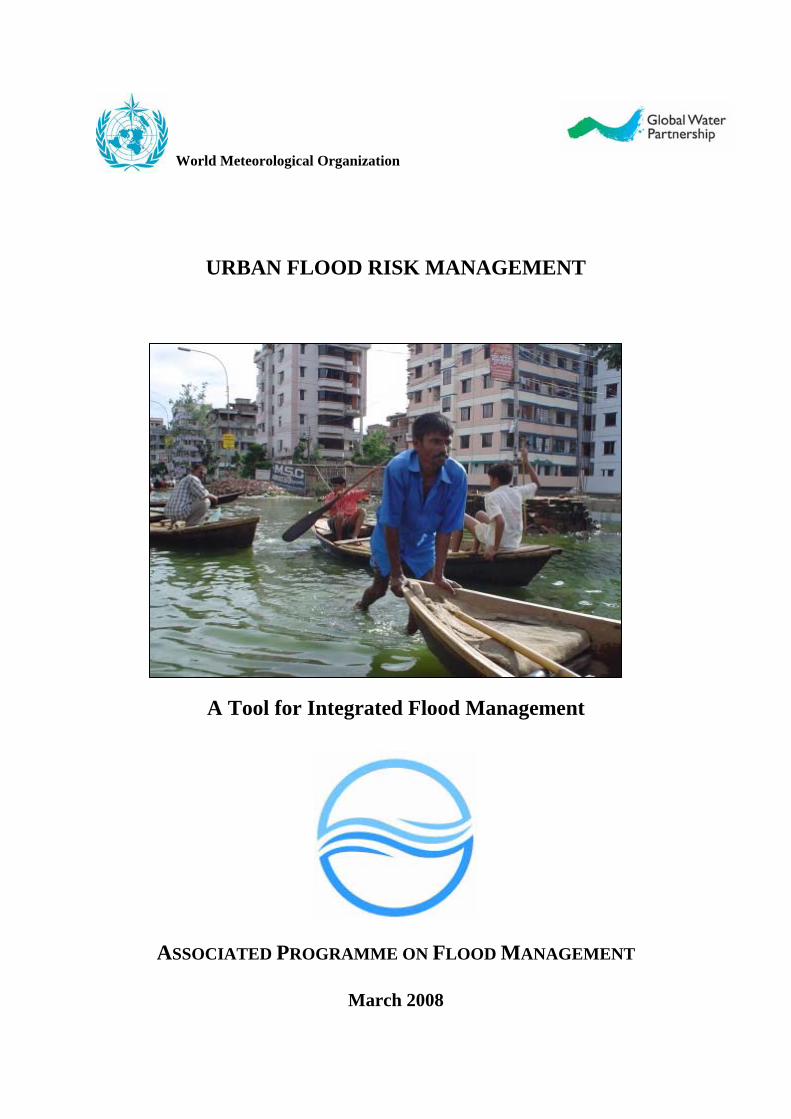
A Tool for Integrated Flood Management
X X X X X X
ASSOCIATED PROGRAMME ON FLOOD MANAGEMENT
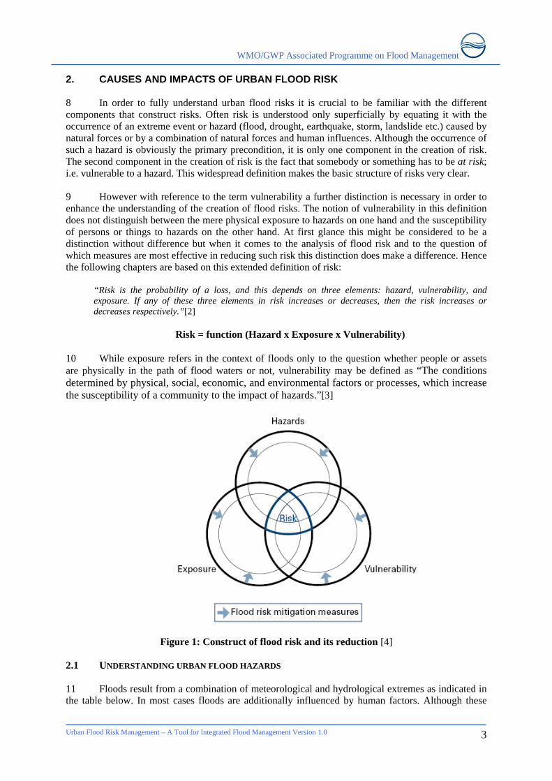
March 2008
WMO/GWP Associated Programme on Flood Management
Urban Flood Risk Management – A Tool for Integrated Flood Management Version 1.0
2
The Associated Programme on Flood Management (APFM) is a joint initiative of the World Meteorological Organization (WMO) and the Global Water Partnership (GWP). It promotes the concept of Integrated Flood Management (IFM) as a new approach to flood management. The programme is financially supported by the governments of Japan and the Netherlands. The World Meteorological Organization (WMO) is a specialized agency of the United Nations. It coordinates the activities of the meteorological and hydrological services of 188 countries and territories and such is the centre of knowledge about weather, climate and water. The Global Water Partnership is an international network open to all organizations involved in water resources management. It was created in 1996 to foster Integrated Water Resources Management (IWRM).
WMO/GWP Associated Programme on Flood Management
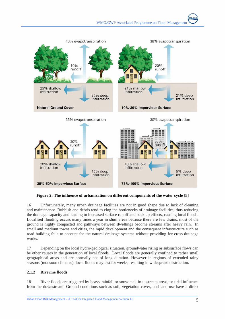
Urban Flood Risk Management – A Tool for Integrated Flood Management Version 1.0
3
Note for the reader
This publication is part of the “Flood Management Tools Series” being compiled by the Associated Programme on Flood Management. The contained Tool for “Urban Flood Management” is based on available literature, and draws findings from relevant works wherever possible. This Tool addresses the needs of practitioners and allows them to easily access relevant guidance materials. The Tool is considered as a resource guide/material for practitioners and not an academic paper. References used are mostly available on the Internet and hyperlinks are provided in the “References” section. This Tool is a “living document” and will be updated based on sharing of experiences with its readers. The Associated Programme on Flood Management encourages flood managers and related experts engaged in environmental assessment around the globe to participate in the enrichment of the Tool. For the purpose comments and other inputs are cordially invited. Authorship and contributions would be appropriately acknowledged. Please kindly submit your inputs to the following Email address: [email protected] under Subject: “Urban Flood Management Tool”.
Acknowledgements This Tool has exploited the works of many organizations and experts, as listed in the references. Acknowledgement is due to the members of the Climate and Water Department in WMO and the members of the Technical Support Unit of the APFM for their competent technical guidance and frank discussions on the issues and for bringing various perspectives into focus.
Disclaimer
The designations employed and the presentation of material in this publication do not imply the expression of any opinion whatsoever on the part of the Secretariat of the World Meteorological Organization concerning the legal status of any country, territory, city, or area, or of its authorities, or concerning the delimitation of its frontiers or boundaries.
APFM Technical Document No. 11, Flood Management Tools Series © WMO, 2008

WMO/GWP Associated Programme on Flood Management
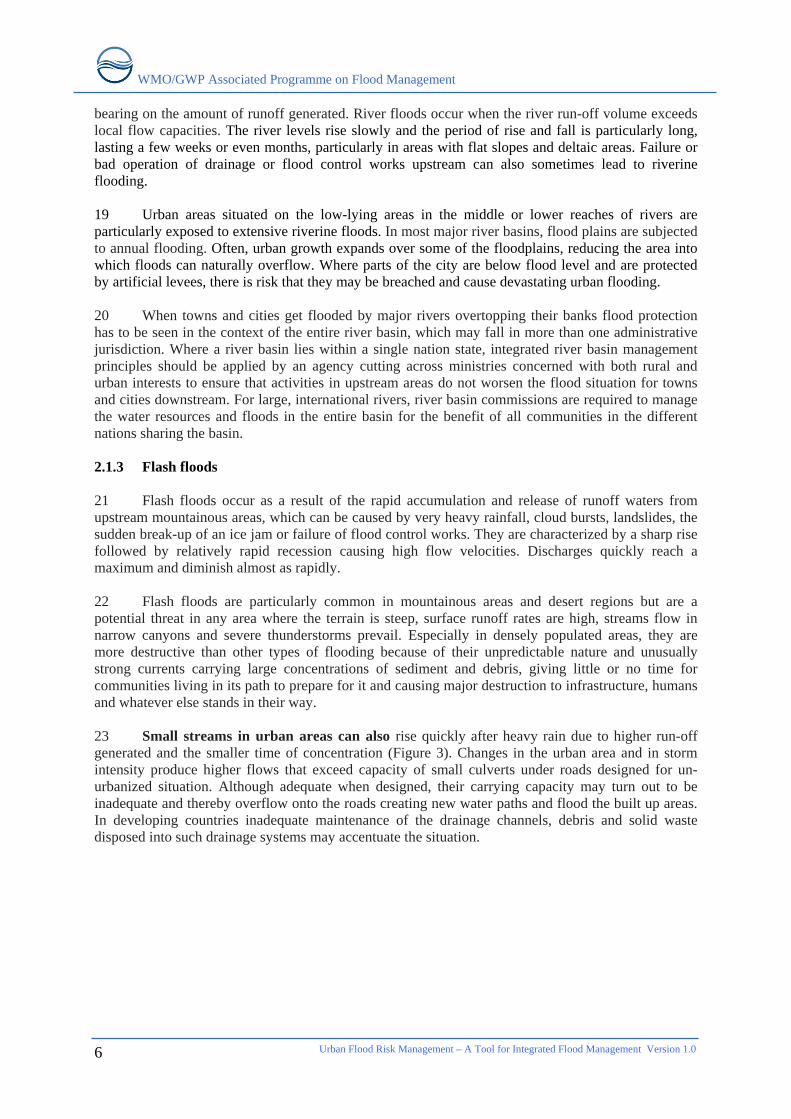
Urban Flood Risk Management – A Tool for Integrated Flood Management Version 1.0
4
WMO/GWP Associated Programme on Flood Management
URBAN FLOOD RISK MANAGEMENT
TABLE OF CONTENTS
1. INTRODUCTION......................................................................................................................... 1 2. CAUSES AND IMPACTS OF URBAN FLOOD RISK ............................................................ 3
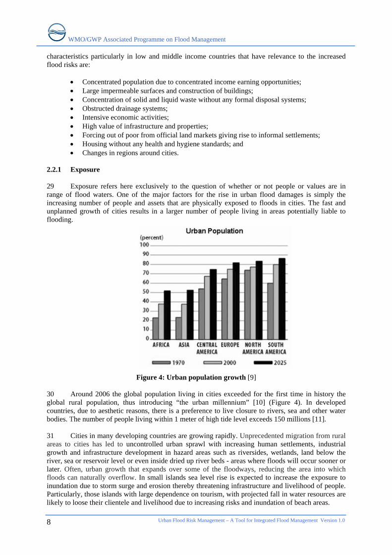
2.1 UNDERSTANDING URBAN FLOOD HAZARDS ............................................................................ 3 2.1.1 Local floods..................................................................................................................... 4 2.1.2 Riverine floods ................................................................................................................ 5 2.1.3 Flash floods ..................................................................................................................... 6 2.1.4 Coastal floods .................................................................................................................. 7 2.1.5 Climate change and flooding........................................................................................... 7
2.2 IMPACTS OF URBAN FLOODS................................................................................................... 7 2.2.1 Exposure.......................................................................................................................... 8 2.2.2 Vulnerability.................................................................................................................... 9
2.3 URBAN FLOOD DAMAGES ..................................................................................................... 11 3. INTEGRATED MANAGEMENT OF URBAN FLOODS...................................................... 13
3.1 AIMS AND APPROACHES ........................................................................................................ 13 3.2 RISK ASSESSMENT................................................................................................................. 14 3.3 RISK MANAGEMENT MEASURES ........................................................................................... 15
3.3.1 Measures to mitigate hazards ........................................................................................ 17 3.3.2 Preventing exposure ...................................................................................................... 23 3.3.3 Reducing vulnerability: building resilience................................................................... 24
4. CONCEPTUAL FRAMEWORK FOR URBAN FLOOD RISK MANAGEMENT............. 28 4.1 MAINSTREAMING FLOOD RISKS IN URBAN PLANNING........................................................... 28
4.1.1 Integrated Flood Management....................................................................................... 29 4.1.2 Total Water Cycle Management.................................................................................... 29 4.1.3 Land-use Planning......................................................................................................... 31
4.2 SURFACE WATER MANAGEMENT PLANS................................................................................ 31 4.3 ORGANIZATIONAL REQUIREMENTS ....................................................................................... 32
4.3.1 Present shortcomings..................................................................................................... 32 4.3.2 Institutional arrangements ............................................................................................. 32
4.4 PARTICIPATORY PLANNING OF MEASURES ........................................................................... 33 5. CONCLUSIONS AND RECOMMENDATIONS .................................................................... 36 REFERENCES .................................................................................................................................... 37
Urban Flood Risk Management – A Tool for Integrated Flood Management Version 1.0
5
WMO/GWP Associated Programme on Flood Management
Urban Flood Risk Management – A Tool for Integrated Flood Management Version 1.0
6
FIGURES Figure 1: Construct of flood risk and its reduction.................................................................................. 3 Figure 2: The influence of urbanization on different components of the water cycle............................. 5 Figure 3: Discharge accentuation due to urbanization ............................................................................ 7 Figure 4: Urban population growth ......................................................................................................... 8 Figure 5: Flood exposure of poor neighbourhood in Manila, Philippines............................................... 9 Figure 6: Categorization of Flood Losses ............................................................................................. 12 Figure 7: Steps of the Risk Management Process ................................................................................. 13 Figure 8: Risk map with a geographical information system (GIS)...................................................... 14 Figure 9: Risk Management Cycle ........................................................................................................ 16 Figure 10: Two major concepts of urban storm drainage: Direct runoff versus source control............ 18 Figure 11: Infiltration Trench................................................................................................................ 19 Figure 12: Multipurpose detention basin in Japan ................................................................................ 19 Figure 13: Clogging of city drains due to solid waste dumping in Dhaka ............................................ 20 Figure 14: Clogged gutter in Accra. ...................................................................................................... 20 Figure 15: Flood plain zoning ............................................................................................................... 23 Figure 16: Examples of flood proofing ................................................................................................. 25 Figure 17: Urban Flood Risk Management: Conceptual Framework ................................................... 28 Figure 18: Major components of the urban hydrologic balance............................................................ 30 Figure 19: Total Water Cycle Management-Concept diagram ............................................................. 31 Figure 20: Ways of decision making..................................................................................................... 34 TABLES Table 1: Factors contributing to flooding................................................................................................ 4
WMO/GWP Associated Programme on Flood Management
Urban Flood Risk Management – A Tool for Integrated Flood Management Version 1.0
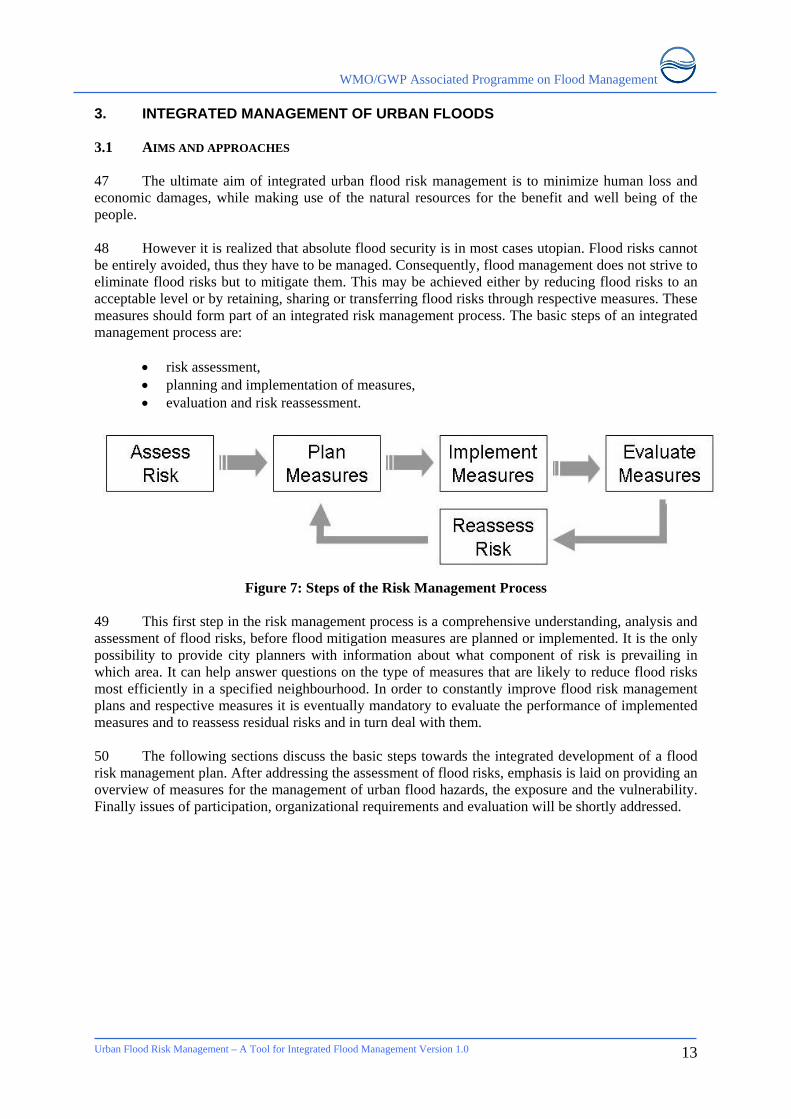
1
1. INTRODUCTION 1 Questions of how to handle flood risk in densely populated areas are as old as many human settlements themselves. Since water supply has been a decisive factor in the search for adequate settlement locations throughout history, river banks and lakesides have become preferred living spaces. Most of the cities are located in the valleys and flood plains or on coasts. The fact that the development of settlements along large rivers has often been more successful than elsewhere is contributed to a set of additional location advantages which offered favourable conditions for development: flood plains in the lower reaches provide fertile and flat land for successful agriculture, navigable rivers offer an accessible means of transportation and the construction of bridges was in many cases the first step in the establishment of prosperous market places. Estuaries and other coastal areas are even more promising as settlement locations since they may serve as linkages between river and sea navigation. However, the cost for such favourable locations is an increased flood risk. 2 Although cities in areas experiencing heavy precipitation due to their very nature of having large impervious areas, so that the rain flood water and wastewater do not infiltrate into the ground, produce large run-off which the drainage network cannot accommodate, are potentially exposed to floods. The riverside towns are particularly at risk due to surface water flooding as well as riverine flooding. 3 Irrespective of whether urban floods are part of larger riverine floods or result from inadequate drainage capacities, the damage potential of floods in cities is extraordinarily high. Given the high spatial concentration of people and values in cities, even small scale floods may lead to considerable damages. In extreme cases urban floods can result in disasters that set back urban development by years or even decades. Recent statistics clearly indicate that economic damages caused by urban floods are rising [1]. On one hand, the continuing urbanization process in combination with an over-proportional growth of values in cities is responsible for this trend, while on the other hand floods are indeed increasing, both in terms of frequency and magnitude. 4 Under these circumstances the sustainable management of urban flood risk is becoming an increasingly challenging task for urban communities and the responsible authorities to address. Unfortunately, many cities all over the world are not able to keep up with the intensification of these challenges. The reasons for that are manifold and some difficulties can hardly be overcome. Yet there exists a common characteristic among many urban flood management plans that inhibits a more effective response to flood risk: mono-sectoral approaches. Too often urban flood management is marked by a narrow view on floods, concentrating on hydraulic and engineering aspects of flood management while ignoring spatial, ecological, political and socio-economic aspects and risks. Such narrow views usually aim to avoid or to absolutely control floods, an endeavour which often proves to be unrealistic. By increasing people’s resilience to floods such approaches ideally enable people to live with floods. 5 The central concern of this paper is to bring the different aspects of urban flood risks together under the umbrella of a risk management approach that aims to explain urban flood risks as well as to show possibilities of how they can be managed successfully. It will be argued that only the combination of spatial, technical and organizational measures will lead to a more sustainable and effective management of urban flood risks. Based on this holistic paradigm this paper is structured into three main chapters. By referring to two basic concepts of urban water and flood management chapter two provides a conceptual framework for the following chapters. Chapter three examines causes and impacts of urban flood risk by distinguishing clearly between its several constituent components. Finally, chapter four can be read as a general guideline towards the integrated management of urban flood risk. Concrete measures as well as organizational requirements are discussed in this chapter in order to illustrate the most important options and steps towards the development of flood risk management plans in cities. ____________________ * [ ] indicate the reference listed at the end of the article
WMO/GWP Associated Programme on Flood Management
Urban Flood Risk Management – A Tool for Integrated Flood Management Version 1.0
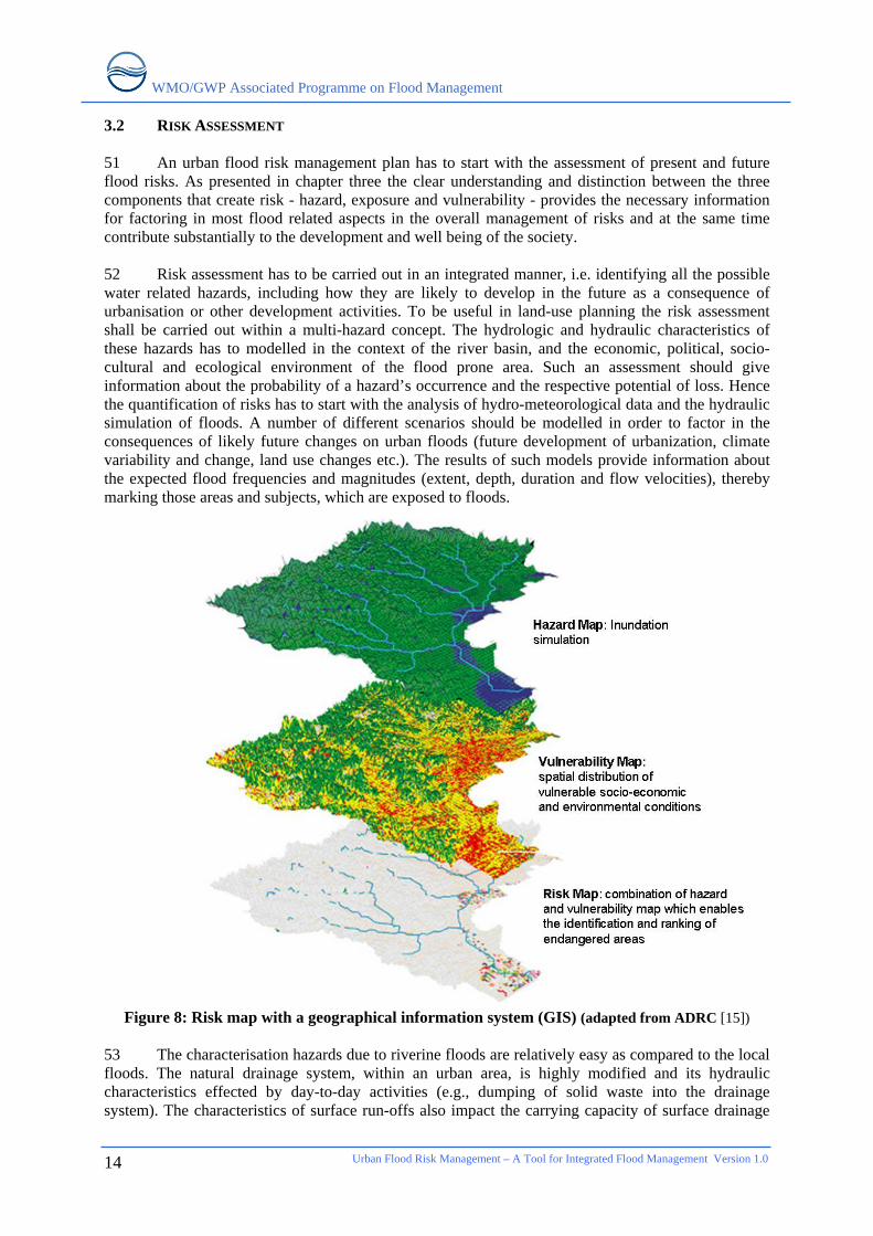
2
6 Audience targeted by this paper is as broad as the implications of urban flood risks. However, since flood management is primarily a public task with full involvement of stakeholders the target group is primarily the staff of the respective municipal authorities, national flood planners, emergency response authorities and the public at large. These include: flood managers, spatial planners, civil engineers, water supply and sanitation services, civil defence authorities and health and social services. 7 This paper should not be seen as a technical manual for urban flood risk management but rather an initiator and starting point for the integrated development of urban flood risk management plans. Wherever possible references to more specific sources of information, predominantly online sources, are given.
WMO/GWP Associated Programme on Flood Management
2. CAUSES AND IMPACTS OF URBAN FLOOD RISK 8 In order to fully understand urban flood risks it is crucial to be familiar with the different components that construct risks. Often risk is understood only superficially by equating it with the occurrence of an extreme event or hazard (flood, drought, earthquake, storm, landslide etc.) caused by natural forces or by a combination of natural forces and human influences. Although the occurrence of such a hazard is obviously the primary precondition, it is only one component in the creation of risk. The second component in the creation of risk is the fact that somebody or something has to be at risk; i.e. vulnerable to a hazard. This widespread definition makes the basic structure of risks very clear. 9 However with reference to the term vulnerability a further distinction is necessary in order to enhance the understanding of the creation of flood risks. The notion of vulnerability in this definition does not distinguish between the mere physical exposure to hazards on one hand and the susceptibility of persons or things to hazards on the other hand. At first glance this might be considered to be a distinction without difference but when it comes to the analysis of flood risk and to the question of which measures are most effective in reducing such risk this distinction does make a difference. Hence the following chapters are based on this extended definition of risk:
“Risk is the probability of a loss, and this depends on three elements: hazard, vulnerability, and exposure. If any of these three elements in risk increases or decreases, then the risk increases or decreases respectively.”[2]
Risk = function (Hazard x Exposure x Vulnerability)
10 While exposure refers in the context of floods only to the question whether people or assets are physically in the path of flood waters or not, vulnerability may be defined as “The conditions determined by physical, social, economic, and environmental factors or processes, which increase the susceptibility of a community to the impact of hazards.”[3]
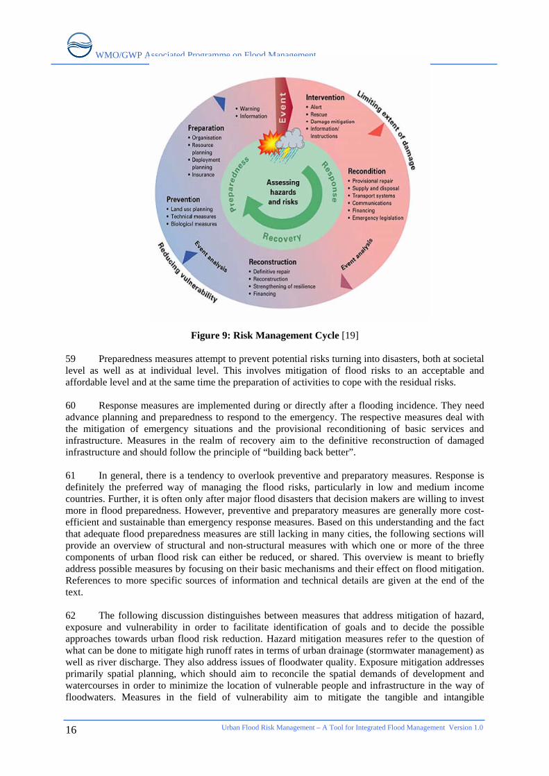
Figure 1: Construct of flood risk and its reduction [4] 2.1 UNDERSTANDING URBAN FLOOD HAZARDS 11 Floods result from a combination of meteorological and hydrological extremes as indicated in the table below. In most cases floods are additionally influenced by human factors. Although these
Urban Flood Risk Management – A Tool for Integrated Flood Management Version 1.0
3
WMO/GWP Associated Programme on Flood Management
Urban Flood Risk Management – A Tool for Integrated Flood Management Version 1.0
4
influences are very diverse, they generally tend to aggravate flood hazards by accentuating flood peaks. Thus flood hazards in built environments have to be seen as the consequence of natural and man-made factors.
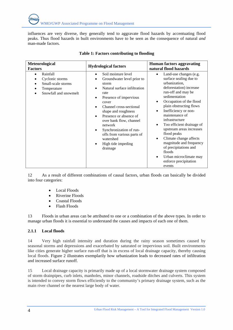
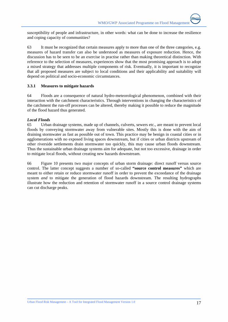
Table 1: Factors contributing to flooding Meteorological Factors Hydrological factors Human factors aggravating
natural flood hazards • Rainfall • Cyclonic storms • Small-scale storms • Temperature • Snowfall and snowmelt
• Soil moisture level • Groundwater level prior to
storm • Natural surface infiltration
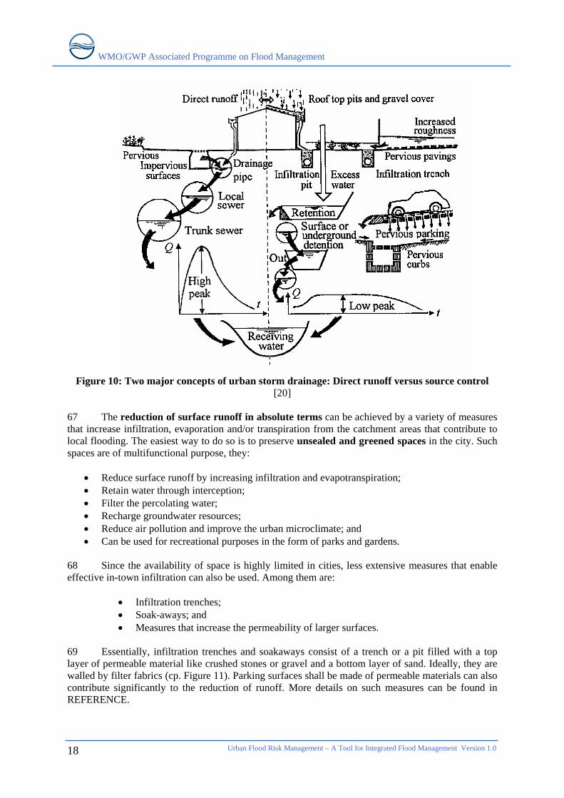
rate • Presence of impervious
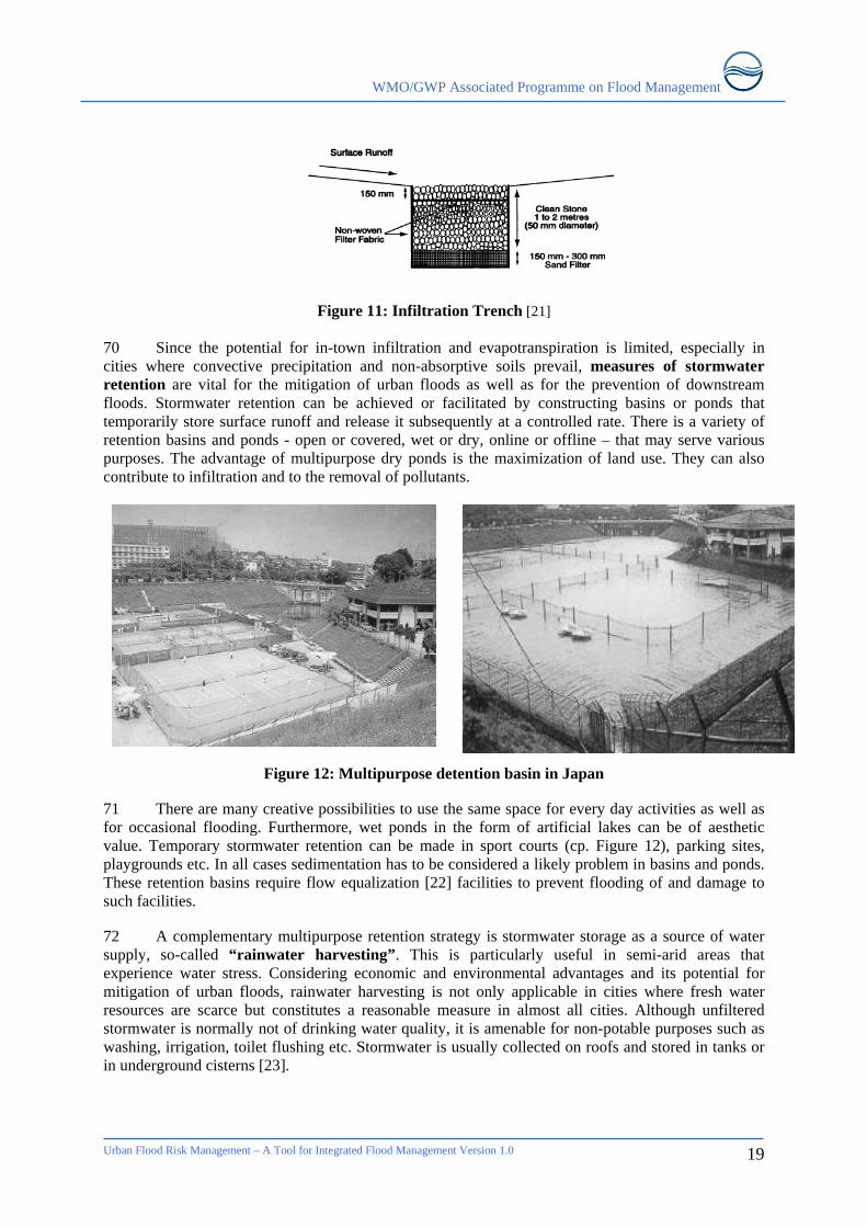
cover • Channel cross-sectional
shape and roughness • Presence or absence of
over bank flow, channel network
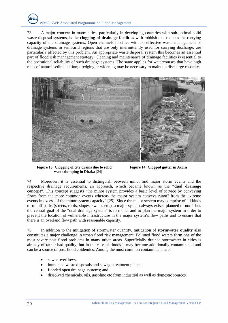
• Synchronization of run-offs from various parts of watershed
• High tide impeding drainage
• Land-use changes (e.g. surface sealing due to urbanization, deforestation) increase run-off and may be sedimentation
• Occupation of the flood plain obstructing flows
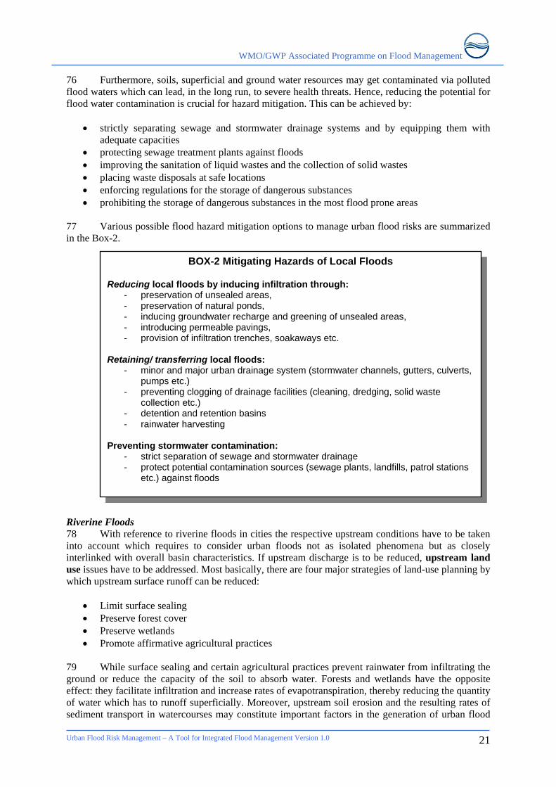
• Inefficiency or non-maintenance of infrastructure
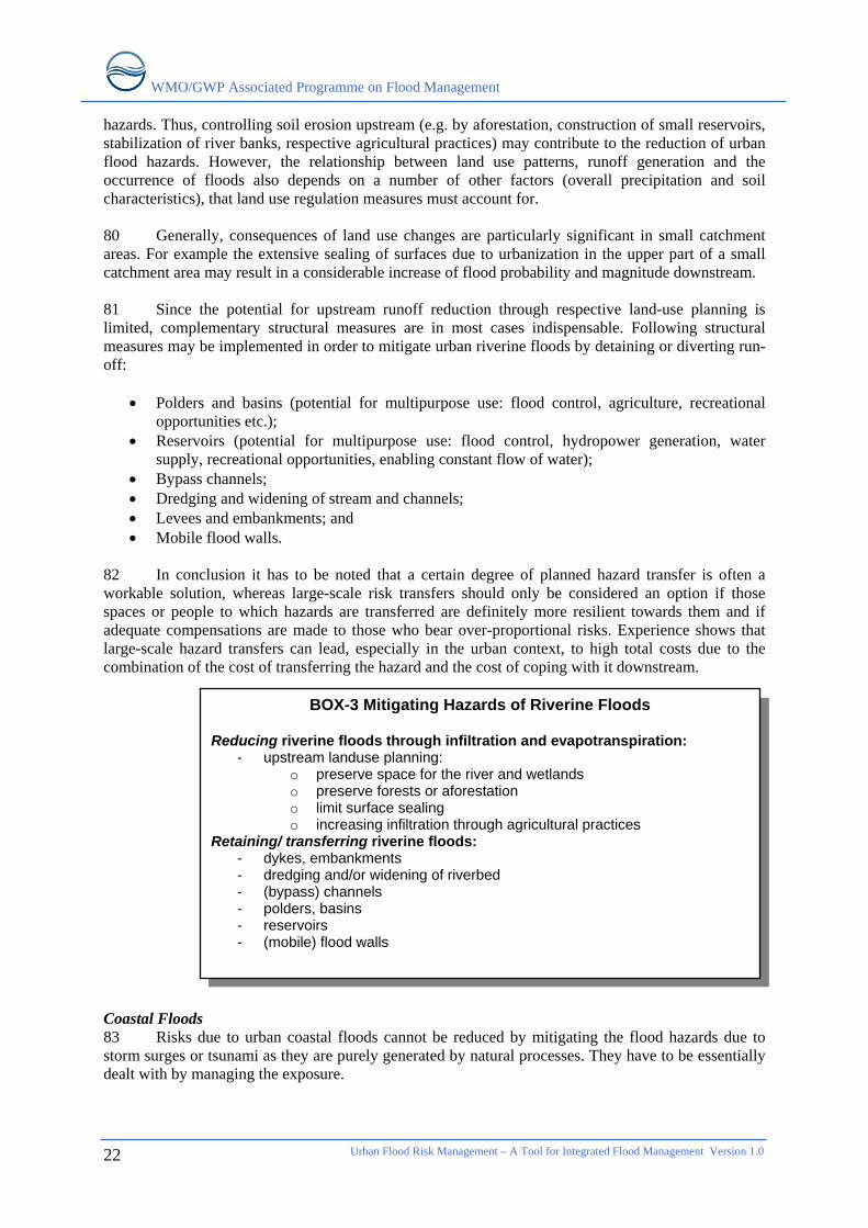
• Too efficient drainage of upstream areas increases flood peaks
• Climate change affects magnitude and frequency of precipitations and floods
• Urban microclimate may enforce precipitation events
12 As a result of different combinations of causal factors, urban floods can basically be divided into four categories:
• Local Floods • Riverine Floods • Coastal Floods • Flash Floods
13 Floods in urban areas can be attributed to one or a combination of the above types. In order to manage urban floods it is essential to understand the causes and impacts of each one of them. 2.1.1 Local floods 14 Very high rainfall intensity and duration during the rainy season sometimes caused by seasonal storms and depressions and exacerbated by saturated or impervious soil. Built environments like cities generate higher surface run-off that is in excess of local drainage capacity, thereby causing local floods. Figure 2 illustrates exemplarily how urbanization leads to decreased rates of infiltration and increased surface runoff. 15 Local drainage capacity is primarily made up of a local stormwater drainage system composed of storm drainpipes, curb inlets, manholes, minor channels, roadside ditches and culverts. This system is intended to convey storm flows efficiently to the community’s primary drainage system, such as the main river channel or the nearest large body of water.
WMO/GWP Associated Programme on Flood Management
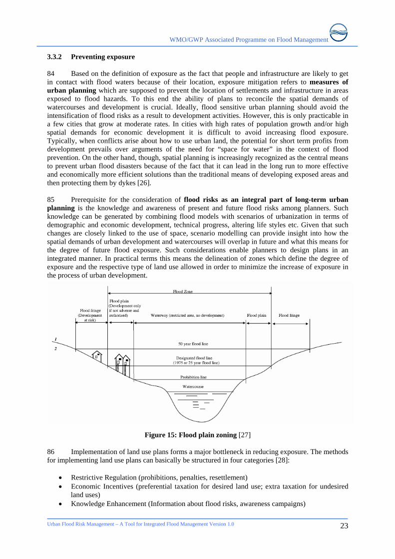
Figure 2: The influence of urbanization on different components of the water cycle [5] 16 Unfortunately, many urban drainage facilities are not in good shape due to lack of cleaning and maintenance. Rubbish and debris tend to clog the bottlenecks of drainage facilities, thus reducing the drainage capacity and leading to increased surface runoff and back up effects, causing local floods. Localised flooding occurs many times a year in slum areas because there are few drains, most of the ground is highly compacted and pathways between dwellings become streams after heavy rain. In small and medium towns and cities, the rapid development and the consequent infrastructure such as road building fails to account for the natural drainage systems without providing for cross-drainage works. 17 Depending on the local hydro-geological situation, groundwater rising or subsurface flows can be other causes in the generation of local floods. Local floods are generally confined to rather small geographical areas and are normally not of long duration. However in regions of extended rainy seasons (monsoon climates), local floods may last for weeks, resulting in widespread destruction. 2.1.2 Riverine floods 18 River floods are triggered by heavy rainfall or snow melt in upstream areas, or tidal influence from the downstream. Ground conditions such as soil, vegetation cover, and land use have a direct
Urban Flood Risk Management – A Tool for Integrated Flood Management Version 1.0
5
WMO/GWP Associated Programme on Flood Management
Urban Flood Risk Management – A Tool for Integrated Flood Management Version 1.0
6
bearing on the amount of runoff generated. River floods occur when the river run-off volume exceeds local flow capacities. The river levels rise slowly and the period of rise and fall is particularly long, lasting a few weeks or even months, particularly in areas with flat slopes and deltaic areas. Failure or bad operation of drainage or flood control works upstream can also sometimes lead to riverine flooding. 19 Urban areas situated on the low-lying areas in the middle or lower reaches of rivers are particularly exposed to extensive riverine floods. In most major river basins, flood plains are subjected to annual flooding. Often, urban growth expands over some of the floodplains, reducing the area into which floods can naturally overflow. Where parts of the city are below flood level and are protected by artificial levees, there is risk that they may be breached and cause devastating urban flooding. 20 When towns and cities get flooded by major rivers overtopping their banks flood protection has to be seen in the context of the entire river basin, which may fall in more than one administrative jurisdiction. Where a river basin lies within a single nation state, integrated river basin management principles should be applied by an agency cutting across ministries concerned with both rural and urban interests to ensure that activities in upstream areas do not worsen the flood situation for towns and cities downstream. For large, international rivers, river basin commissions are required to manage the water resources and floods in the entire basin for the benefit of all communities in the different nations sharing the basin. 2.1.3 Flash floods 21 Flash floods occur as a result of the rapid accumulation and release of runoff waters from upstream mountainous areas, which can be caused by very heavy rainfall, cloud bursts, landslides, the sudden break-up of an ice jam or failure of flood control works. They are characterized by a sharp rise followed by relatively rapid recession causing high flow velocities. Discharges quickly reach a maximum and diminish almost as rapidly. 22 Flash floods are particularly common in mountainous areas and desert regions but are a potential threat in any area where the terrain is steep, surface runoff rates are high, streams flow in narrow canyons and severe thunderstorms prevail. Especially in densely populated areas, they are more destructive than other types of flooding because of their unpredictable nature and unusually strong currents carrying large concentrations of sediment and debris, giving little or no time for communities living in its path to prepare for it and causing major destruction to infrastructure, humans and whatever else stands in their way. 23 Small streams in urban areas can also rise quickly after heavy rain due to higher run-off generated and the smaller time of concentration (Figure 3). Changes in the urban area and in storm intensity produce higher flows that exceed capacity of small culverts under roads designed for un-urbanized situation. Although adequate when designed, their carrying capacity may turn out to be inadequate and thereby overflow onto the roads creating new water paths and flood the built up areas. In developing countries inadequate maintenance of the drainage channels, debris and solid waste disposed into such drainage systems may accentuate the situation.
WMO/GWP Associated Programme on Flood Management
Figure 3: Discharge accentuation due to urbanization [6] 2.1.4 Coastal floods 24 High tides and storm surges caused by tropical depressions and cyclones can cause coastal floods in urban areas located at estuaries, tidal flats and low-lying land near the sea in general. Coastline configurations, offshore water depth and estuary shape can influence the intensity of coastal floods. Moreover, high tides may impede the discharge of rivers and drainage systems, leading to local or riverine floods. Tidal effects in the estuarine reaches can keep the river levels high for long periods of time and sustain flooding. Thus the cities located in estuarine reaches have to bear the combined impacts of riverine as well as coastal floods due to storm surges and tidal effects. Coastal areas are exposed to sea erosion, which is particularly likely with the increase in the sea roughness due to climate change. 25 Tsunamis, mainly triggered by powerful offshore earthquakes, can also cause coastal floods though infrequently. 2.1.5 Climate change and flooding 26 Due to global warming many subsystems of the global water cycle are likely to intensify, resulting in many regions in an increase of flood magnitude as well as flood frequency [7]. Climate change is making weather less predictable, rains more uncertain and heavy storm rainfalls more likely. Heavy thunderstorm rains appear to have increased in frequency. Urban areas may help to increase thunderstorm activity because their built-up surfaces attain higher temperatures than surrounding areas and create a local air circulation that produces an ’urban heat island’. Dust particles caught up in that circulation act as nuclei on which moisture in clouds condenses, forming rain droplets that eventually may develop into the large rain drops of a major thunderstorm. 27 Sea-level rise increases the risk of coastal floods, particularly in case of storm surges. Many million more people are projected to be flooded every year due to sea-level rise by 2080s. Those densely populated low-lying areas where adaptive capacity is relatively low are especially at risk [8]. Climate change also works in an indirect way to aggravate urban flooding. 2.2 IMPACTS OF URBAN FLOODS 28 Urban floods have large impacts particularly in terms of economic losses both direct and indirect. Flood risks are a function of exposure of the people and the economic activities along with the vulnerability of social and economic fabric. As such the impact of such floods on the lives and livelihoods of people, a function of their vulnerability, needs to be understood. A number of urban
Urban Flood Risk Management – A Tool for Integrated Flood Management Version 1.0
7
WMO/GWP Associated Programme on Flood Management
Urban Flood Risk Management – A Tool for Integrated Flood Management Version 1.0
8
characteristics particularly in low and middle income countries that have relevance to the increased flood risks are:
• Concentrated population due to concentrated income earning opportunities; • Large impermeable surfaces and construction of buildings; • Concentration of solid and liquid waste without any formal disposal systems; • Obstructed drainage systems; • Intensive economic activities; • High value of infrastructure and properties; • Forcing out of poor from official land markets giving rise to informal settlements; • Housing without any health and hygiene standards; and • Changes in regions around cities.
2.2.1 Exposure 29 Exposure refers here exclusively to the question of whether or not people or values are in range of flood waters. One of the major factors for the rise in urban flood damages is simply the increasing number of people and assets that are physically exposed to floods in cities. The fast and unplanned growth of cities results in a larger number of people living in areas potentially liable to flooding.
Figure 4: Urban population growth [9]
30 Around 2006 the global population living in cities exceeded for the first time in history the global rural population, thus introducing “the urban millennium” [10] (Figure 4). In developed countries, due to aesthetic reasons, there is a preference to live closure to rivers, sea and other water bodies. The number of people living within 1 meter of high tide level exceeds 150 millions [11]. 31 Cities in many developing countries are growing rapidly. Unprecedented migration from rural areas to cities has led to uncontrolled urban sprawl with increasing human settlements, industrial growth and infrastructure development in hazard areas such as riversides, wetlands, land below the river, sea or reservoir level or even inside dried up river beds - areas where floods will occur sooner or later. Often, urban growth that expands over some of the floodways, reducing the area into which floods can naturally overflow. In small islands sea level rise is expected to increase the exposure to inundation due to storm surge and erosion thereby threatening infrastructure and livelihood of people. Particularly, those islands with large dependence on tourism, with projected fall in water resources are likely to loose their clientele and livelihood due to increasing risks and inundation of beach areas.
WMO/GWP Associated Programme on Flood Management
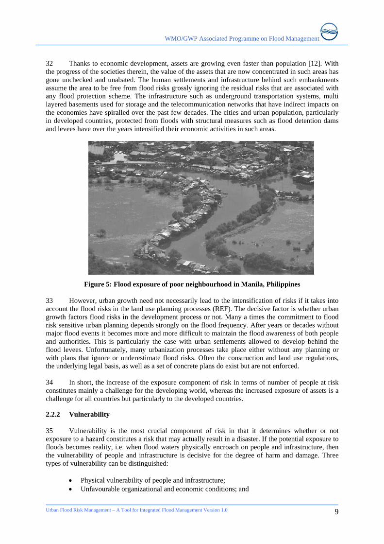
32 Thanks to economic development, assets are growing even faster than population [12]. With the progress of the societies therein, the value of the assets that are now concentrated in such areas has gone unchecked and unabated. The human settlements and infrastructure behind such embankments assume the area to be free from flood risks grossly ignoring the residual risks that are associated with any flood protection scheme. The infrastructure such as underground transportation systems, multi layered basements used for storage and the telecommunication networks that have indirect impacts on the economies have spiralled over the past few decades. The cities and urban population, particularly in developed countries, protected from floods with structural measures such as flood detention dams and levees have over the years intensified their economic activities in such areas.
Figure 5: Flood exposure of poor neighbourhood in Manila, Philippines 33 However, urban growth need not necessarily lead to the intensification of risks if it takes into account the flood risks in the land use planning processes (REF). The decisive factor is whether urban growth factors flood risks in the development process or not. Many a times the commitment to flood risk sensitive urban planning depends strongly on the flood frequency. After years or decades without major flood events it becomes more and more difficult to maintain the flood awareness of both people and authorities. This is particularly the case with urban settlements allowed to develop behind the flood levees. Unfortunately, many urbanization processes take place either without any planning or with plans that ignore or underestimate flood risks. Often the construction and land use regulations, the underlying legal basis, as well as a set of concrete plans do exist but are not enforced. 34 In short, the increase of the exposure component of risk in terms of number of people at risk constitutes mainly a challenge for the developing world, whereas the increased exposure of assets is a challenge for all countries but particularly to the developed countries. 2.2.2 Vulnerability 35 Vulnerability is the most crucial component of risk in that it determines whether or not exposure to a hazard constitutes a risk that may actually result in a disaster. If the potential exposure to floods becomes reality, i.e. when flood waters physically encroach on people and infrastructure, then the vulnerability of people and infrastructure is decisive for the degree of harm and damage. Three types of vulnerability can be distinguished:
• Physical vulnerability of people and infrastructure; • Unfavourable organizational and economic conditions; and
Urban Flood Risk Management – A Tool for Integrated Flood Management Version 1.0
9
WMO/GWP Associated Programme on Flood Management
Urban Flood Risk Management – A Tool for Integrated Flood Management Version 1.0
10
• Attitudes and motivations. 36 While a detailed discussion on these vulnerabilities are given elsewhere, these are discussed in the urban context in the following sections in order to address them to avoid a flooding event turning into disaster both at societal level as well as at individual level. Physical vulnerability of people and infrastructure 37 Urban development inherently creates larger risks, but those in higher income groups are able to avoid or bear such risks while those with low incomes cope with them to their detriment. There is a clear socio-spatial segregation with reference to the hazard exposure of settlement locations. Since urbanization is essentially the increase of population density, space gets rare and expensive. Consequently those who cannot afford to purchase or to rent space in secure environments are forced to move to cheaper places. Such locations may be found at the outskirts of town or in areas inside town where the wealthier do not want to live, e.g. because these areas are prone to floods or other hazards. Given the fact that the livelihood of the urban poor often depends on the proximity to informal economies in the central areas of big cities, many prefer to inhabit hazard areas inside town. Two more factors aggravate this spatial marginalization. On one hand hazard prone areas are often not privately owned, and thus informal dwellers are less likely to get displaced. On the other hand, however, many urban poor are migrants from rural areas who are not familiar with the respective hazards and therefore tend to underestimate the risk of living in such exposed areas. 38 The physical vulnerability of urban populations tends to increase as a result of the dense concentration of potentially dangerous infrastructure and substances in urban areas (bridges, solid and liquid waste, chemicals, electric facilities etc.). Existence of health threatening infrastructure such as sewage treatment plants (usually located at very low spots), waste dumps or dangerous industries at such locations increases additionally the risk of secondary hazards and damages. Special attention in the context of human settlement locations has to be paid to socio-economic factors. 39 Obviously healthy and young people are more likely to resist physical stresses than sick and old people. On the other hand those who are familiar with a given stress situation might have developed certain adaptation techniques that allow them to cope with floods despite of their disadvantaged physical condition. Similar explanations apply to infrastructure. Although concrete houses are less likely to get destroyed by floods other more simple houses might be less vulnerable provided that they are well-adapted to floods, e.g. stilt houses. Briefly, the vulnerability to flood risks in urban settlements, particularly in developing countries in informal developments can be attributed to the following factors:
• Risk prone areas are the only areas that the poor migrants are able to afford • Failure to perceive flood risks due to lack of knowledge till a flood strikes • Infrastructure to reduce risk is not economically viable • Flooding (particularly local flooding) occurs so regularly that they become accustomed to
living with risks Unfavourable organizational and economic conditions 40 Informal settlement dwellers are unable to act effectively together. As such they face difficulties in getting support from government and make use of institutional mechanism to the betterment of their conditions. The lack of organizational structures may lead to chaotic circumstances in times of stress whereas the existence of formal or informal organizations or institutions may constitute a stabilizing factor. 41 In any case mutual support among community members is crucial for coping with stress situations. Such informal social networks are often the only “insurance” of the poor and are particularly important if official support is weak. Unfortunately it belongs to the characteristics of urban poverty that social networks tend to be weaker in cities than in villages. Livelihoods of people
WMO/GWP Associated Programme on Flood Management
living in informal settlements, is dependent on their daily earning capacities, which is severely effected by flooding. On the other hand, those who have regular source of livelihood, their income is not disrupted by floods. Economic vulnerability prevails obviously among those households who lack financial resources and those who cannot afford or are reluctant to purchase flood insurances. Attitudes and motivations 42 Reluctance towards flood preparedness and mitigation measures may be the result of lacking hazard knowledge or of fatalistic attitudes. Moreover, dependence on too much external support can reduce the individual responsibility to deal with problems in a proactive manner. 43 Like exposure, vulnerabilities should not be considered merely as given unsafe conditions but as the result of different processes, which finally make people and their belongings more or less susceptible to the impact of hazards. Among the root causes of these processes, socio-economic factors are the driving forces, including access to or exclusion from education, medical facilities, economic opportunities, political participation and the use of natural resources. Those entitlements usually depend on the socio-cultural background of people in terms of class, ethnic origin, gender and religion. In the case of a hazardous event, access to such entitlements enable “… a person or group in terms of their capacity to anticipate, cope with, resist and recover from the impact of a natural hazard” [13]. Such capacities are also referred to as resilience, the opposite of vulnerability. 2.3 URBAN FLOOD DAMAGES 44 The impacts of urban floods can be:
• Physical • Economic, and • Environmental
45 In addition to the exposure and vulnerability, discussed in previous sections, the magnitude of the damage depends on the flood type (especially in terms of depth, flow velocity, water quality, duration and sediment load). While in rural areas the damages due to floods are mostly direct in terms of loss of agricultural production, the damages in urban context are more complex. Damages due to floods can be categorized as indicated in Box-1. Figure 6 provides an overview of typical flood losses and distinguishes moreover between primary, secondary and tertiary loss categories. Although the impacts of urban floods are almost exclusively adverse, it should be kept in mind that riverine floods in rural areas often have positive ecological effects.
BOX-1 Losses due to floods Direct losses: Losses resulting from direct contact with flood water, to buildings and infrastructure Indirect losses: Losses resulting from the event but not from its direct impact, for example, transport disruption, business losses that can’t be made up, losses of family income etc. In both loss categories, there are two clear sub-categories of loss: Tangible losses: Loss of things that have a monetary (replacement) value, for example, buildings, livestock, infrastructure etc. Intangible losses: Loss of things that cannot be bought and sold, for example, lives and injuries, heritage items, memorabilia etc.
46 It is important to understand the construct of likely flood damages in a given situation in order to take preventive actions to mitigate these likely damages. Both direct and indirect primary potential losses can be prevented through better land use planning, which also impact the potential secondary losses. Better flood emergency response mechanisms help reduce potential secondary losses.
Urban Flood Risk Management – A Tool for Integrated Flood Management Version 1.0
11

WMO/GWP Associated Programme on Flood Management
Urban Flood Risk Management – A Tool for Integrated Flood Management Version 1.0
12
Figure 6: Categorization of Flood Losses [14]
FLOOD LOSSESFLOOD LOSSES
Damage to:• Buildings (e.g. houses)• Contents of buildings• Infrastructure (e.g. roads, bridges)• Crops and animals
Damage to:• Buildings (e.g. houses)• Contents of buildings• Infrastructure (e.g. roads, bridges)• Crops and animals
TANGIBLEINDIRECT LOSSES
TANGIBLEDIRECT LOSSES
INTANGIBLEHUMAN AND OTHERLOSSES
Loss of, or disruption, to:• Agricultural production• Industrial production• Communications (e.g. road, rail and
telecommunications)• Health care and education services• Utility supplies (e.g. electricity)
Loss of, or disruption, to:• Agricultural production• Industrial production• Communications (e.g. road, rail and
telecommunications)• Health care and education services• Utility supplies (e.g. electricity)
• Loss of life• Physical injury• Loss of heritage or archaeological site
• Loss of life• Physical injury• Loss of heritage or archaeological site
• Flood causes fire and fire damage• Salt in seawater contaminates land and
reduces crop yields• Flood cuts electricity supply, damaging
susceptible machines and computer runs
• Flood causes fire and fire damage• Salt in seawater contaminates land and
reduces crop yields• Flood cuts electricity supply, damaging
susceptible machines and computer runs
• Lost value added in industry• Increased traffic congestion and costs• Disruption of flow of employees to work
causing “knock-on”effects• Contamination of water supplies• Food and other shortages• Increased costs of emergency services• Loss of income• Increased household costs
• Lost value added in industry• Increased traffic congestion and costs• Disruption of flow of employees to work
causing “knock-on”effects• Contamination of water supplies• Food and other shortages• Increased costs of emergency services• Loss of income• Increased household costs
• Increased stress• Physical and psychological trauma• Increase in flood-related suicides• Increase in water-borne diseases• Increase in ill health• Increase in post-flood visits to doctors• Hastened and/or increased mortality
• Increased stress• Physical and psychological trauma• Increase in flood-related suicides• Increase in water-borne diseases• Increase in ill health• Increase in post-flood visits to doctors• Hastened and/or increased mortality
• Enhanced rate of property deterioration and decay
• Long-term rot and damp• Structures are weakened, making them
more damage prone in subsequent floods
• Enhanced rate of property deterioration and decay
• Long-term rot and damp• Structures are weakened, making them
more damage prone in subsequent floods
• Some businesses are bankrupt• Loss of exports• Reduced national gross domestic product
• Some businesses are bankrupt• Loss of exports• Reduced national gross domestic product
• Homelessness• Loss of livelihoods• Total loss of possessions (i.e. uninsured)• Blighted families• Lost communities where communities are
broken up
• Homelessness• Loss of livelihoods• Total loss of possessions (i.e. uninsured)• Blighted families• Lost communities where communities are
broken up
PRIMARY
SECONDARY
TERTIARY
WMO/GWP Associated Programme on Flood Management
3. INTEGRATED MANAGEMENT OF URBAN FLOODS 3.1 AIMS AND APPROACHES 47 The ultimate aim of integrated urban flood risk management is to minimize human loss and economic damages, while making use of the natural resources for the benefit and well being of the people. 48 However it is realized that absolute flood security is in most cases utopian. Flood risks cannot be entirely avoided, thus they have to be managed. Consequently, flood management does not strive to eliminate flood risks but to mitigate them. This may be achieved either by reducing flood risks to an acceptable level or by retaining, sharing or transferring flood risks through respective measures. These measures should form part of an integrated risk management process. The basic steps of an integrated management process are:
• risk assessment, • planning and implementation of measures, • evaluation and risk reassessment.
Figure 7: Steps of the Risk Management Process 49 This first step in the risk management process is a comprehensive understanding, analysis and assessment of flood risks, before flood mitigation measures are planned or implemented. It is the only possibility to provide city planners with information about what component of risk is prevailing in which area. It can help answer questions on the type of measures that are likely to reduce flood risks most efficiently in a specified neighbourhood. In order to constantly improve flood risk management plans and respective measures it is eventually mandatory to evaluate the performance of implemented measures and to reassess residual risks and in turn deal with them. 50 The following sections discuss the basic steps towards the integrated development of a flood risk management plan. After addressing the assessment of flood risks, emphasis is laid on providing an overview of measures for the management of urban flood hazards, the exposure and the vulnerability. Finally issues of participation, organizational requirements and evaluation will be shortly addressed.
Urban Flood Risk Management – A Tool for Integrated Flood Management Version 1.0
13
WMO/GWP Associated Programme on Flood Management
Urban Flood Risk Management – A Tool for Integrated Flood Management Version 1.0
14
3.2 RISK ASSESSMENT 51 An urban flood risk management plan has to start with the assessment of present and future flood risks. As presented in chapter three the clear understanding and distinction between the three components that create risk - hazard, exposure and vulnerability - provides the necessary information for factoring in most flood related aspects in the overall management of risks and at the same time contribute substantially to the development and well being of the society. 52 Risk assessment has to be carried out in an integrated manner, i.e. identifying all the possible water related hazards, including how they are likely to develop in the future as a consequence of urbanisation or other development activities. To be useful in land-use planning the risk assessment shall be carried out within a multi-hazard concept. The hydrologic and hydraulic characteristics of these hazards has to modelled in the context of the river basin, and the economic, political, socio-cultural and ecological environment of the flood prone area. Such an assessment should give information about the probability of a hazard’s occurrence and the respective potential of loss. Hence the quantification of risks has to start with the analysis of hydro-meteorological data and the hydraulic simulation of floods. A number of different scenarios should be modelled in order to factor in the consequences of likely future changes on urban floods (future development of urbanization, climate variability and change, land use changes etc.). The results of such models provide information about the expected flood frequencies and magnitudes (extent, depth, duration and flow velocities), thereby marking those areas and subjects, which are exposed to floods.
Figure 8: Risk map with a geographical information system (GIS) (adapted from ADRC [15]) 53 The characterisation hazards due to riverine floods are relatively easy as compared to the local floods. The natural drainage system, within an urban area, is highly modified and its hydraulic characteristics effected by day-to-day activities (e.g., dumping of solid waste into the drainage system). The characteristics of surface run-offs also impact the carrying capacity of surface drainage
WMO/GWP Associated Programme on Flood Management
system in urban areas. As such, determination of the likely flood prone areas due to localised flooding is complicated and has to be undertaken with greater understanding of the drainage systems. 54 Using the geographical definition of exposed areas, it is possible to make a first assessment of the potential damages. Most commonly this is achieved by undertaking survey of the economic values and assets located in these areas. In combination with data about flood frequency and magnitude the economic risk can be calculated and expressed, e.g. in terms of damage per square meter per year ($/m²/a) or in damage curves [16]. 55 Products of risk assessments are risk maps that enable the users to clearly identify the most endangered areas and neighbourhoods. In addition to the identification of risk areas, the advantage of such comprehensive risk assessments is the fact that it is possible to compare the components of risk in quantitative terms, thereby identifying those risk components, which contribute most to the risk creation. The latter links risk assessment with risk management measures by indicating those areas where preventive mitigation measures can reduce risks most effectively. 56 Risk assessment should not be seen as an exercise in getting numbers that indicate risk. Such numbers do provide an overview of the financial burden to which a flood event may lead, but they fail to project non-economic aspects of vulnerability. This shortcoming has two respects. First, many objects in poor communities overall in informal settlements are of very low financial value but nonetheless they might be crucial for livelihoods, and thus their destruction can have very severe consequences. Secondly, a risk assessment that takes only economic aspects into account does not provide information about the community’s vulnerability in social and environmental terms nor does it adequately express the community’s capacity to cope with emergency situations. 57 Normally such qualitative aspects are noted at the margin of risk assessments but effort is rarely made to operationalize them and to incorporate them systematically in the risk assessment. Obviously it is difficult to find indicators that reflect social vulnerability or social resilience in a satisfactory manner, but there are risk assessment methodologies that do provide promising suggestions of how these issues can be factored in. Such approaches bring many different single indicators from various relevant fields together and develop aggregated indices for flood hazard and vulnerability. Moreover these indices can be combined into one comprehensive risk index, which expresses the overall level of risk of a given location and its inhabitants [17][18]. 3.3 RISK MANAGEMENT MEASURES 58 The composition of risk, as analysed from risk assessment exercise can help address not only the efforts towards flood risk management but also in improving the well being of people, particularly if the analysis points toward need to build resilience in the effected population. This is more true for the countries with low or medium income. However, the following paragraphs will largely focus on flood risk management and the resilience building will be peripherally mentioned in so far it addresses the flood risks. Flood risk management has to follow the stages of a risk cycle (cp. Figure 9), through
• Preparedness; • Response; and • Recovery
Urban Flood Risk Management – A Tool for Integrated Flood Management Version 1.0
15
WMO/GWP Associated Programme on Flood Management
Urban Flood Risk Management – A Tool for Integrated Flood Management Version 1.0
16
Figure 9: Risk Management Cycle [19] 59 Preparedness measures attempt to prevent potential risks turning into disasters, both at societal level as well as at individual level. This involves mitigation of flood risks to an acceptable and affordable level and at the same time the preparation of activities to cope with the residual risks. 60 Response measures are implemented during or directly after a flooding incidence. They need advance planning and preparedness to respond to the emergency. The respective measures deal with the mitigation of emergency situations and the provisional reconditioning of basic services and infrastructure. Measures in the realm of recovery aim to the definitive reconstruction of damaged infrastructure and should follow the principle of “building back better”. 61 In general, there is a tendency to overlook preventive and preparatory measures. Response is definitely the preferred way of managing the flood risks, particularly in low and medium income countries. Further, it is often only after major flood disasters that decision makers are willing to invest more in flood preparedness. However, preventive and preparatory measures are generally more cost-efficient and sustainable than emergency response measures. Based on this understanding and the fact that adequate flood preparedness measures are still lacking in many cities, the following sections will provide an overview of structural and non-structural measures with which one or more of the three components of urban flood risk can either be reduced, or shared. This overview is meant to briefly address possible measures by focusing on their basic mechanisms and their effect on flood mitigation. References to more specific sources of information and technical details are given at the end of the text. 62 The following discussion distinguishes between measures that address mitigation of hazard, exposure and vulnerability in order to facilitate identification of goals and to decide the possible approaches towards urban flood risk reduction. Hazard mitigation measures refer to the question of what can be done to mitigate high runoff rates in terms of urban drainage (stormwater management) as well as river discharge. They also address issues of floodwater quality. Exposure mitigation addresses primarily spatial planning, which should aim to reconcile the spatial demands of development and watercourses in order to minimize the location of vulnerable people and infrastructure in the way of floodwaters. Measures in the field of vulnerability aim to mitigate the tangible and intangible
WMO/GWP Associated Programme on Flood Management
susceptibility of people and infrastructure, in other words: what can be done to increase the resilience and coping capacity of communities? 63 It must be recognized that certain measures apply to more than one of the three categories, e.g. measures of hazard transfer can also be understood as measures of exposure reduction. Hence, the discussion has to be seen to be an exercise in practise rather than making theoretical distinction. With reference to the selection of measures, experiences show that the most promising approach is to adopt a mixed strategy that addresses multiple components of risk. Eventually, it is important to recognize that all proposed measures are subject to local conditions and their applicability and suitability will depend on political and socio-economic circumstances. 3.3.1 Measures to mitigate hazards 64 Floods are a consequence of natural hydro-meteorological phenomenon, combined with their interaction with the catchment characteristics. Through interventions in changing the characteristics of the catchment the run-off processes can be altered, thereby making it possible to reduce the magnitude of the flood hazard thus generated. Local Floods 65 Urban drainage systems, made up of channels, culverts, sewers etc., are meant to prevent local floods by conveying stormwater away from vulnerable sites. Mostly this is done with the aim of draining stormwater as fast as possible out of town. This practice may be benign in coastal cities or in agglomerations with no exposed living spaces downstream, but if cities or urban districts upstream of other riverside settlements drain stormwater too quickly, this may cause urban floods downstream. Thus the sustainable urban drainage systems aim for adequate, but not too excessive, drainage in order to mitigate local floods, without creating new hazards downstream. 66 Figure 10 presents two major concepts of urban storm drainage: direct runoff versus source control. The latter concept suggests a number of so-called “source control measures” which are meant to either retain or reduce stormwater runoff in order to prevent the exceedance of the drainage system and to mitigate the generation of flood hazards downstream. The resulting hydrographs illustrate how the reduction and retention of stormwater runoff in a source control drainage systems can cut discharge peaks.
Urban Flood Risk Management – A Tool for Integrated Flood Management Version 1.0
17
WMO/GWP Associated Programme on Flood Management
Urban Flood Risk Management – A Tool for Integrated Flood Management Version 1.0
18
Figure 10: Two major concepts of urban storm drainage: Direct runoff versus source control [20]
67 The reduction of surface runoff in absolute terms can be achieved by a variety of measures that increase infiltration, evaporation and/or transpiration from the catchment areas that contribute to local flooding. The easiest way to do so is to preserve unsealed and greened spaces in the city. Such spaces are of multifunctional purpose, they:
• Reduce surface runoff by increasing infiltration and evapotranspiration; • Retain water through interception; • Filter the percolating water; • Recharge groundwater resources; • Reduce air pollution and improve the urban microclimate; and • Can be used for recreational purposes in the form of parks and gardens.
68 Since the availability of space is highly limited in cities, less extensive measures that enable effective in-town infiltration can also be used. Among them are:
• Infiltration trenches; • Soak-aways; and • Measures that increase the permeability of larger surfaces.
69 Essentially, infiltration trenches and soakaways consist of a trench or a pit filled with a top layer of permeable material like crushed stones or gravel and a bottom layer of sand. Ideally, they are walled by filter fabrics (cp. Figure 11). Parking surfaces shall be made of permeable materials can also contribute significantly to the reduction of runoff. More details on such measures can be found in REFERENCE.
WMO/GWP Associated Programme on Flood Management
Figure 11: Infiltration Trench [21] 70 Since the potential for in-town infiltration and evapotranspiration is limited, especially in cities where convective precipitation and non-absorptive soils prevail, measures of stormwater retention are vital for the mitigation of urban floods as well as for the prevention of downstream floods. Stormwater retention can be achieved or facilitated by constructing basins or ponds that temporarily store surface runoff and release it subsequently at a controlled rate. There is a variety of retention basins and ponds - open or covered, wet or dry, online or offline – that may serve various purposes. The advantage of multipurpose dry ponds is the maximization of land use. They can also contribute to infiltration and to the removal of pollutants.
Figure 12: Multipurpose detention basin in Japan 71 There are many creative possibilities to use the same space for every day activities as well as for occasional flooding. Furthermore, wet ponds in the form of artificial lakes can be of aesthetic value. Temporary stormwater retention can be made in sport courts (cp. Figure 12), parking sites, playgrounds etc. In all cases sedimentation has to be considered a likely problem in basins and ponds. These retention basins require flow equalization [22] facilities to prevent flooding of and damage to such facilities. 72 A complementary multipurpose retention strategy is stormwater storage as a source of water supply, so-called “rainwater harvesting”. This is particularly useful in semi-arid areas that experience water stress. Considering economic and environmental advantages and its potential for mitigation of urban floods, rainwater harvesting is not only applicable in cities where fresh water resources are scarce but constitutes a reasonable measure in almost all cities. Although unfiltered stormwater is normally not of drinking water quality, it is amenable for non-potable purposes such as washing, irrigation, toilet flushing etc. Stormwater is usually collected on roofs and stored in tanks or in underground cisterns [23].
Urban Flood Risk Management – A Tool for Integrated Flood Management Version 1.0
19
WMO/GWP Associated Programme on Flood Management
Urban Flood Risk Management – A Tool for Integrated Flood Management Version 1.0
20
73 A major concern in many cities, particularly in developing countries with sub-optimal solid waste disposal systems, is the clogging of drainage facilities with rubbish that reduces the carrying capacity of the drainage systems. Open channels in cities with no effective waste management or drainage systems in semi-arid regions that are only intermittently used for carrying discharge, are particularly affected by this problem. An appropriate waste disposal system this becomes an essential part of flood risk management strategy. Cleaning and maintenance of drainage facilities is essential to the operational reliability of such drainage systems. The same applies for watercourses that have high rates of natural sedimentation; dredging or widening may be necessary to maintain discharge capacity.
Figure 13: Clogging of city drains due to solid waste dumping in Dhaka Figure 14: Clogged gutter in Accra.
Figure 13: Clogging of city drains due to solid Figure 14: Clogged gutter in Accra waste dumping in Dhaka [24] 74 Moreover, it is essential to distinguish between minor and major storm events and the respective drainage requirements, an approach, which became known as the “dual drainage concept”. This concept suggests “the minor system provides a basic level of service by conveying flows from the more common events whereas the major system conveys runoff from the extreme events in excess of the minor system capacity” [25]. Since the major system may comprise of all kinds of runoff paths (streets, roofs, slopes, swales etc.), a major system always exists, planned or not. Thus the central goal of the “dual drainage system” is to model and to plan the major system in order to prevent the location of vulnerable infrastructure in the major system’s flow paths and to ensure that there is an overland flow path with reasonable capacity. 75 In addition to the mitigation of stormwater quantity, mitigation of stormwater quality also constitutes a major challenge in urban flood risk management. Polluted flood waters form one of the most severe post flood problems in many urban areas. Superficially drained stormwater in cities is already of rather bad quality, but in the case of floods it may become additionally contaminated and can be a source of post flood epidemics. Among the most common contaminants are:
• sewer overflows; • inundated waste disposals and sewage treatment plants; • flooded open drainage systems; and • dissolved chemicals, oils, gasoline etc from industrial as well as domestic sources.
WMO/GWP Associated Programme on Flood Management
76 Furthermore, soils, superficial and ground water resources may get contaminated via polluted flood waters which can lead, in the long run, to severe health threats. Hence, reducing the potential for flood water contamination is crucial for hazard mitigation. This can be achieved by:
• strictly separating sewage and stormwater drainage systems and by equipping them with adequate capacities
• protecting sewage treatment plants against floods • improving the sanitation of liquid wastes and the collection of solid wastes • placing waste disposals at safe locations • enforcing regulations for the storage of dangerous substances • prohibiting the storage of dangerous substances in the most flood prone areas
77 Various possible flood hazard mitigation options to manage urban flood risks are summarized in the Box-2.
BOX-2 Mitigating Hazards of Local Floods Reducing local floods by inducing infiltration through:
- preservation of unsealed areas, - preservation of natural ponds, - inducing groundwater recharge and greening of unsealed areas, - introducing permeable pavings, - provision of infiltration trenches, soakaways etc.
Retaining/ transferring local floods:
- minor and major urban drainage system (stormwater channels, gutters, culverts, pumps etc.)
- preventing clogging of drainage facilities (cleaning, dredging, solid waste collection etc.)
- detention and retention basins - rainwater harvesting
Preventing stormwater contamination:
- strict separation of sewage and stormwater drainage - protect potential contamination sources (sewage plants, landfills, patrol stations
etc.) against floods
Riverine Floods 78 With reference to riverine floods in cities the respective upstream conditions have to be taken into account which requires to consider urban floods not as isolated phenomena but as closely interlinked with overall basin characteristics. If upstream discharge is to be reduced, upstream land use issues have to be addressed. Most basically, there are four major strategies of land-use planning by which upstream surface runoff can be reduced:
• Limit surface sealing • Preserve forest cover • Preserve wetlands • Promote affirmative agricultural practices
79 While surface sealing and certain agricultural practices prevent rainwater from infiltrating the ground or reduce the capacity of the soil to absorb water. Forests and wetlands have the opposite effect: they facilitate infiltration and increase rates of evapotranspiration, thereby reducing the quantity of water which has to runoff superficially. Moreover, upstream soil erosion and the resulting rates of sediment transport in watercourses may constitute important factors in the generation of urban flood
Urban Flood Risk Management – A Tool for Integrated Flood Management Version 1.0
21
WMO/GWP Associated Programme on Flood Management
Urban Flood Risk Management – A Tool for Integrated Flood Management Version 1.0
22
hazards. Thus, controlling soil erosion upstream (e.g. by aforestation, construction of small reservoirs, stabilization of river banks, respective agricultural practices) may contribute to the reduction of urban flood hazards. However, the relationship between land use patterns, runoff generation and the occurrence of floods also depends on a number of other factors (overall precipitation and soil characteristics), that land use regulation measures must account for. 80 Generally, consequences of land use changes are particularly significant in small catchment areas. For example the extensive sealing of surfaces due to urbanization in the upper part of a small catchment area may result in a considerable increase of flood probability and magnitude downstream. 81 Since the potential for upstream runoff reduction through respective land-use planning is limited, complementary structural measures are in most cases indispensable. Following structural measures may be implemented in order to mitigate urban riverine floods by detaining or diverting run-off:
• Polders and basins (potential for multipurpose use: flood control, agriculture, recreational opportunities etc.);
• Reservoirs (potential for multipurpose use: flood control, hydropower generation, water supply, recreational opportunities, enabling constant flow of water);
• Bypass channels; • Dredging and widening of stream and channels; • Levees and embankments; and • Mobile flood walls.
82 In conclusion it has to be noted that a certain degree of planned hazard transfer is often a workable solution, whereas large-scale risk transfers should only be considered an option if those spaces or people to which hazards are transferred are definitely more resilient towards them and if adequate compensations are made to those who bear over-proportional risks. Experience shows that large-scale hazard transfers can lead, especially in the urban context, to high total costs due to the combination of the cost of transferring the hazard and the cost of coping with it downstream. Coastal Floods 83 Risks due to urban coastal floods cannot be reduced by mitigating the flood hazards due to storm surges or tsunami as they are purely generated by natural processes. They have to be essentially dealt with by managing the exposure.
BOX-3 Mitigating Hazards of Riverine Floods Reducing riverine floods through infiltration and evapotranspiration:
- upstream landuse planning: o preserve space for the river and wetlands o preserve forests or aforestation o limit surface sealing o increasing infiltration through agricultural practices
Retaining/ transferring riverine floods: - dykes, embankments - dredging and/or widening of riverbed - (bypass) channels - polders, basins - reservoirs - (mobile) flood walls
WMO/GWP Associated Programme on Flood Management
3.3.2 Preventing exposure 84 Based on the definition of exposure as the fact that people and infrastructure are likely to get in contact with flood waters because of their location, exposure mitigation refers to measures of urban planning which are supposed to prevent the location of settlements and infrastructure in areas exposed to flood hazards. To this end the ability of plans to reconcile the spatial demands of watercourses and development is crucial. Ideally, flood sensitive urban planning should avoid the intensification of flood risks as a result to development activities. However, this is only practicable in a few cities that grow at moderate rates. In cities with high rates of population growth and/or high spatial demands for economic development it is difficult to avoid increasing flood exposure. Typically, when conflicts arise about how to use urban land, the potential for short term profits from development prevails over arguments of the need for “space for water” in the context of flood prevention. On the other hand, though, spatial planning is increasingly recognized as the central means to prevent urban flood disasters because of the fact that it can lead in the long run to more effective and economically more efficient solutions than the traditional means of developing exposed areas and then protecting them by dykes [26]. 85 Prerequisite for the consideration of flood risks as an integral part of long-term urban planning is the knowledge and awareness of present and future flood risks among planners. Such knowledge can be generated by combining flood models with scenarios of urbanization in terms of demographic and economic development, technical progress, altering life styles etc. Given that such changes are closely linked to the use of space, scenario modelling can provide insight into how the spatial demands of urban development and watercourses will overlap in future and what this means for the degree of future flood exposure. Such considerations enable planners to design plans in an integrated manner. In practical terms this means the delineation of zones which define the degree of exposure and the respective type of land use allowed in order to minimize the increase of exposure in the process of urban development.
Figure 15: Flood plain zoning [27] 86 Implementation of land use plans forms a major bottleneck in reducing exposure. The methods for implementing land use plans can basically be structured in four categories [28]:
• Restrictive Regulation (prohibitions, penalties, resettlement) • Economic Incentives (preferential taxation for desired land use; extra taxation for undesired
land uses) • Knowledge Enhancement (Information about flood risks, awareness campaigns)
Urban Flood Risk Management – A Tool for Integrated Flood Management Version 1.0
23
WMO/GWP Associated Programme on Flood Management
Urban Flood Risk Management – A Tool for Integrated Flood Management Version 1.0
24
• Public Investment (Purchase property, locate public facilities outside floodplain) 87 Unsuccessful implementation of land use plans is in many municipalities a consequence of too strong of a reliance on the methods of restrictive regulation, which not only creates opposition to municipal authorities but may also lead to increased reluctance towards flood risk management in general. It is crucial for the successful implementation of land use plans that there is a continuous dialogue and communication conveying the necessity of the intended measures and to ensure public support by building awareness. 88 A major obstacle for the elaboration and implementation of flood sensitive land use plans are sectoral and territorial boundaries. Sectoral boundaries in the sense that flood management and urban planning are often part of different municipal departments with staff with different training backgrounds. Both aspects may hinder the realization of flood sensitive land use plans. Territorial boundaries may also be an obstacle in the sense that many large cities or conurbations are subdivided into a number of smaller planning units or even independent municipalities that can hamper the coordination between authorities and thus the adjustment of plans.
3.3.3 Reducing vulnerability: building resilience 89 Vulnerabilities are generally not just the given circumstances, but rather unsafe conditions which have developed by human actions or inactions. It is essential to be aware of the root causes of these vulnerabilities in order to mitigate whenever possible the underlying causes and not merely the consequences. The goal of reducing vulnerability is to reduce the susceptibility of people, livelihoods and infrastructure to floods. 90 Many of such root causes can be found in aspects of poverty, this is why sustainable vulnerability reduction will in many cities be closely linked to measures of poverty reduction. Moreover, the factors that render people vulnerable to floods are often the same, which cause vulnerability to other hazards. Measures for vulnerability reduction, therefore, should be addressed through a multi-hazard approach. One possibility to structure the numerous facets of vulnerability is to distinguish between physical, constitutional-economic and informational-motivational aspects of vulnerability. The following paragraphs will follow this structure. 91 The physical vulnerability of people in case of flood events is largely determined by their initial physical constitution, which in turn, depends on adequate nutrition and medical care. Thus facilitating proper access to food supply and to medical facilities should not only be considered as emergency relief actions in the case of disasters but also as preventive measures to reduce vulnerability in those neighbourhoods where access to such basic needs is not guaranteed.
BOX-4 Integration of flood risks in urban planning
1. Delineation of risk zones 2. Definition of land-use for different risk zones 3. Implementation of land-use regulations through:
• restrictive regulation (prohibitions, penalties, resettlement) • economic incentives (preferential taxation for desired land-uses,
extra taxation for undesired land-use) • knowledge enhancement (communicating necessity for regulations,
awareness campaigns) • public investment (purchase of property)
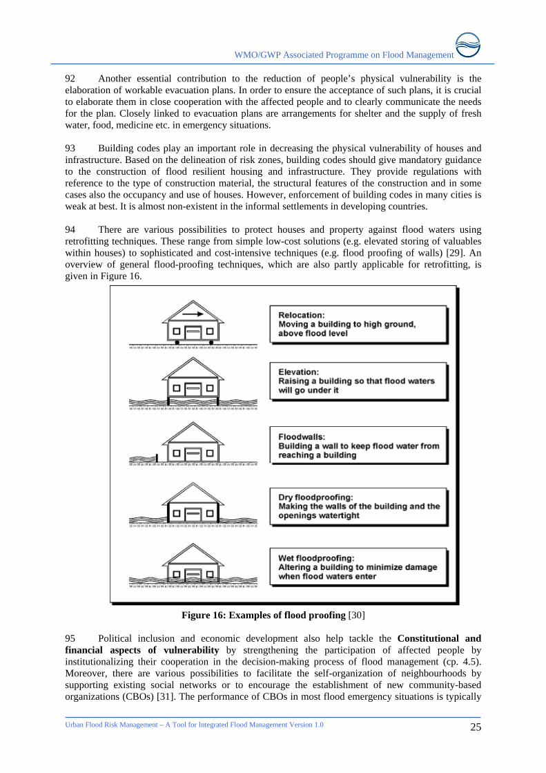
WMO/GWP Associated Programme on Flood Management
92 Another essential contribution to the reduction of people’s physical vulnerability is the elaboration of workable evacuation plans. In order to ensure the acceptance of such plans, it is crucial to elaborate them in close cooperation with the affected people and to clearly communicate the needs for the plan. Closely linked to evacuation plans are arrangements for shelter and the supply of fresh water, food, medicine etc. in emergency situations. 93 Building codes play an important role in decreasing the physical vulnerability of houses and infrastructure. Based on the delineation of risk zones, building codes should give mandatory guidance to the construction of flood resilient housing and infrastructure. They provide regulations with reference to the type of construction material, the structural features of the construction and in some cases also the occupancy and use of houses. However, enforcement of building codes in many cities is weak at best. It is almost non-existent in the informal settlements in developing countries. 94 There are various possibilities to protect houses and property against flood waters using retrofitting techniques. These range from simple low-cost solutions (e.g. elevated storing of valuables within houses) to sophisticated and cost-intensive techniques (e.g. flood proofing of walls) [29]. An overview of general flood-proofing techniques, which are also partly applicable for retrofitting, is given in Figure 16.
Figure 16: Examples of flood proofing [30] 95 Political inclusion and economic development also help tackle the Constitutional and financial aspects of vulnerability by strengthening the participation of affected people by institutionalizing their cooperation in the decision-making process of flood management (cp. 4.5). Moreover, there are various possibilities to facilitate the self-organization of neighbourhoods by supporting existing social networks or to encourage the establishment of new community-based organizations (CBOs) [31]. The performance of CBOs in most flood emergency situations is typically
Urban Flood Risk Management – A Tool for Integrated Flood Management Version 1.0
25
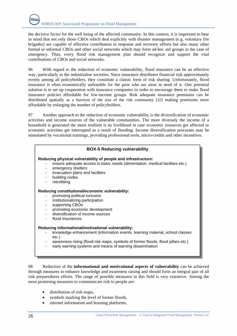
WMO/GWP Associated Programme on Flood Management
Urban Flood Risk Management – A Tool for Integrated Flood Management Version 1.0
26
the decisive factor for the well being of the affected community. In this context, it is important to bear in mind that not only those CBOs which deal explicitly with disaster management (e.g. voluntary fire brigades) are capable of effective contribution to response and recovery efforts but also many other formal or informal CBOs and other social networks which may form ad-hoc aid groups in the case of emergency. Thus, every flood risk management plan should recognize and support the vital contributions of CBOs and social networks. 96 With regard to the reduction of economic vulnerability, flood insurance can be an effective way, particularly in the industrialise societies. Since insurance distributes financial risk approximately evenly among all policyholders, they constitute a classic form of risk sharing. Unfortunately, flood insurance is often economically unfeasible for the poor who are most in need of it. One potential solution is to set up cooperation with insurance companies in order to encourage them to make flood insurance policies affordable for low-income groups. Risk adequate insurance premiums can be distributed spatially as a function of the size of the risk community [32] making premiums more affordable by enlarging the number of policyholders. 97 Another approach to the reduction of economic vulnerability is the diversification of economic activities and income sources of the vulnerable communities. The more diversely the income of a household is generated the more resilient is its livelihood in case economic resources get affected or economic activities get interrupted as a result of flooding. Income diversification processes may be stimulated by vocational trainings, providing professional tools, micro-credits and other incentives. 98 Reduction of the informational and motivational aspects of vulnerability can be achieved through measures to enhance knowledge and awareness raising and should form an integral part of all risk preparedness efforts. The range of possible measures in this field is very extensive. Among the most promising measures to communicate risk to people are:
• distribution of risk maps, • symbols marking the level of former floods, • internet information and learning platforms,
BOX-5 Reducing vulnerability Reducing physical vulnerability of people and infrastructure:
- ensure adequate access to basic needs (alimentation, medical facilities etc.) - emergency shelters - evacuation plans and facilities - building codes - retrofitting
Reducing constitutional/economic vulnerability:
- promoting political inclusion - institutionalizing participation - supporting CBOs - promoting economic development - diversification of income sources - flood insurances
Reducing informational/motivational vulnerability:
- knowledge enhancement (information events, learning material, school classes etc.)
- awareness rising (flood risk maps, symbols of former floods, flood pillars etc.) - early warning systems and means of warning dissemination
WMO/GWP Associated Programme on Flood Management
• information events such as photo exhibitions, • informal trainings, • classes in schools.
99 In all of the cases, it is essential to adapt the way information is presented to the respective socio-cultural settings, composition of the targeted population as well as to include local or traditional knowledge in the creation of information material. 100 Early warning systems to generate time-sensitive information about flood risk which need to be communicated to the communities at risk. In case of flash floods such systems play a very crucial role in saving lives. Although in most cities it is difficult to reliably forecast floods caused by exceeded drainage capacities, it is generally practical to produce warnings in the case of riverine floods. However, the installation of hydrological and meteorological forecasting systems or generating such information is only the first step in the formation of a comprehensive warning system. The key challenge is to convert forecast information into practice by setting up workable systems of warning dissemination that enable people to avoid the worst. Success of such a system is closely related to people’s knowledge of flood risk and their familiarity with emergency response procedures; only then will they be able to react appropriately to warnings.
Urban Flood Risk Management – A Tool for Integrated Flood Management Version 1.0
27
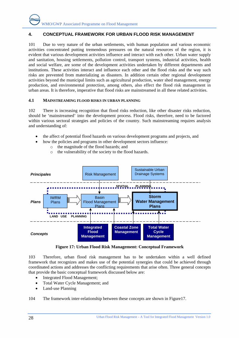
WMO/GWP Associated Programme on Flood Management
Urban Flood Risk Management – A Tool for Integrated Flood Management Version 1.0
28
4. CONCEPTUAL FRAMEWORK FOR URBAN FLOOD RISK MANAGEMENT 101 Due to very nature of the urban settlements, with human population and various economic activities concentrated putting tremendous pressures on the natural resources of the region, it is evident that various development activities influence and interact with each other. Urban water supply and sanitation, housing settlements, pollution control, transport systems, industrial activities, health and social welfare, are some of the development activities undertaken by different departments and institutions. These activities interact and influence each other and the flood risks and the way such risks are prevented from materializing as disasters. In addition certain other regional development activities beyond the municipal limits such as agricultural production, water shed management, energy production, and environmental protection, among others, also effect the flood risk management in urban areas. It is therefore, imperative that flood risks are mainstreamed in all these related activities. 4.1 MAINSTREAMING FLOOD RISKS IN URBAN PLANNING 102 There is increasing recognition that flood risks reduction, like other disaster risks reduction, should be ‘mainstreamed’ into the development process. Flood risks, therefore, need to be factored within various sectoral strategies and policies of the country. Such mainstreaming requires analysis and understanding of:
• the affect of potential flood hazards on various development programs and projects, and • how the policies and programs in other development sectors influence:
o the magnitude of the flood hazards; and o the vulnerability of the society to the flood hazards.
Figure 17: Urban Flood Risk Management: Conceptual Framework
103 Therefore, urban flood risk management has to be undertaken within a well defined framework that recognizes and makes use of the potential synergies that could be achieved through coordinated actions and addresses the conflicting requirements that arise often. Three general concepts that provide the basic conceptual framework discussed below are:
• Integrated Flood Management; • Total Water Cycle Management; and • Land-use Planning
104 The framework inter-relationship between these concepts are shown in Figure17.
LAND USE PLANNING
Storm Water Management
Plans
Basin Flood Management
Plans
Principales
Plans
Concepts
Risk Management
Sustainable Urban Drainage Systems
Total Water Cycle
Management
Integrated Flood
Management
IWRM Plans
SPATIAL PLANNING
Coastal Zone Management
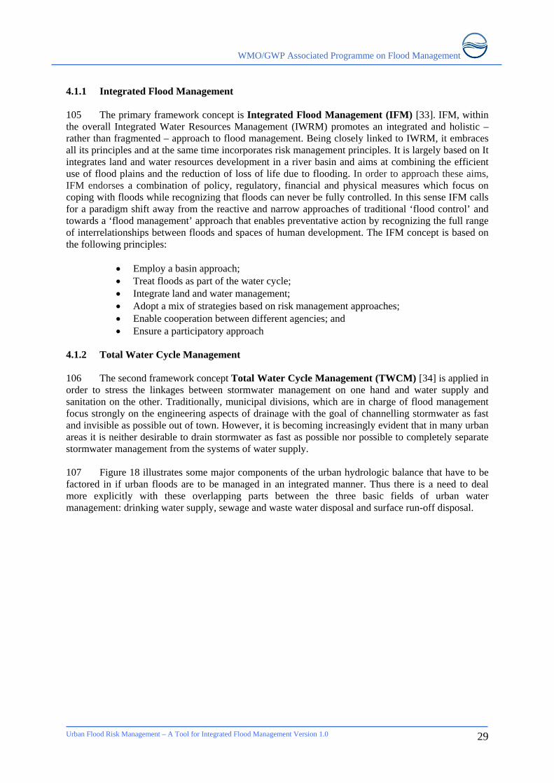
WMO/GWP Associated Programme on Flood Management
4.1.1 Integrated Flood Management 105 The primary framework concept is Integrated Flood Management (IFM) [33]. IFM, within the overall Integrated Water Resources Management (IWRM) promotes an integrated and holistic – rather than fragmented – approach to flood management. Being closely linked to IWRM, it embraces all its principles and at the same time incorporates risk management principles. It is largely based on It integrates land and water resources development in a river basin and aims at combining the efficient use of flood plains and the reduction of loss of life due to flooding. In order to approach these aims, IFM endorses a combination of policy, regulatory, financial and physical measures which focus on coping with floods while recognizing that floods can never be fully controlled. In this sense IFM calls for a paradigm shift away from the reactive and narrow approaches of traditional ‘flood control’ and towards a ‘flood management’ approach that enables preventative action by recognizing the full range of interrelationships between floods and spaces of human development. The IFM concept is based on the following principles:
• Employ a basin approach; • Treat floods as part of the water cycle; • Integrate land and water management; • Adopt a mix of strategies based on risk management approaches; • Enable cooperation between different agencies; and • Ensure a participatory approach
4.1.2 Total Water Cycle Management 106 The second framework concept Total Water Cycle Management (TWCM) [34] is applied in order to stress the linkages between stormwater management on one hand and water supply and sanitation on the other. Traditionally, municipal divisions, which are in charge of flood management focus strongly on the engineering aspects of drainage with the goal of channelling stormwater as fast and invisible as possible out of town. However, it is becoming increasingly evident that in many urban areas it is neither desirable to drain stormwater as fast as possible nor possible to completely separate stormwater management from the systems of water supply. 107 Figure 18 illustrates some major components of the urban hydrologic balance that have to be factored in if urban floods are to be managed in an integrated manner. Thus there is a need to deal more explicitly with these overlapping parts between the three basic fields of urban water management: drinking water supply, sewage and waste water disposal and surface run-off disposal.
Urban Flood Risk Management – A Tool for Integrated Flood Management Version 1.0
29
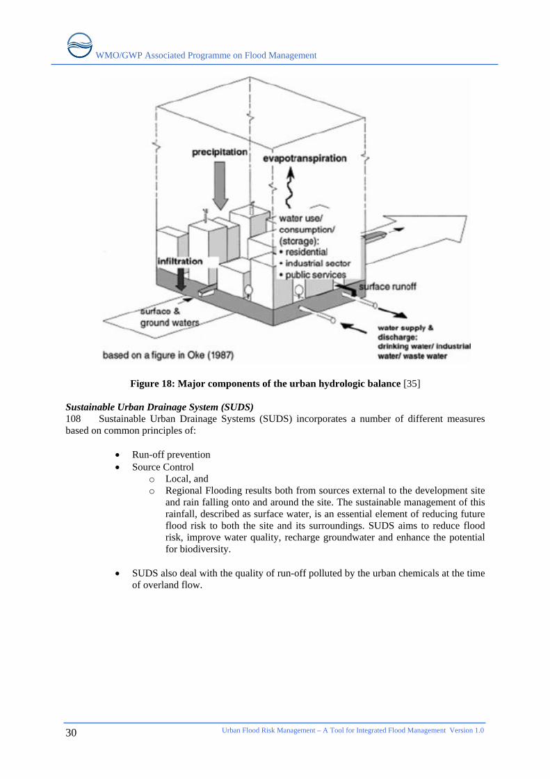
WMO/GWP Associated Programme on Flood Management
Urban Flood Risk Management – A Tool for Integrated Flood Management Version 1.0
30
Figure 18: Major components of the urban hydrologic balance [35] Sustainable Urban Drainage System (SUDS) 108 Sustainable Urban Drainage Systems (SUDS) incorporates a number of different measures based on common principles of:
• Run-off prevention • Source Control
o Local, and o Regional Flooding results both from sources external to the development site
and rain falling onto and around the site. The sustainable management of this rainfall, described as surface water, is an essential element of reducing future flood risk to both the site and its surroundings. SUDS aims to reduce flood risk, improve water quality, recharge groundwater and enhance the potential for biodiversity.
• SUDS also deal with the quality of run-off polluted by the urban chemicals at the time
of overland flow.
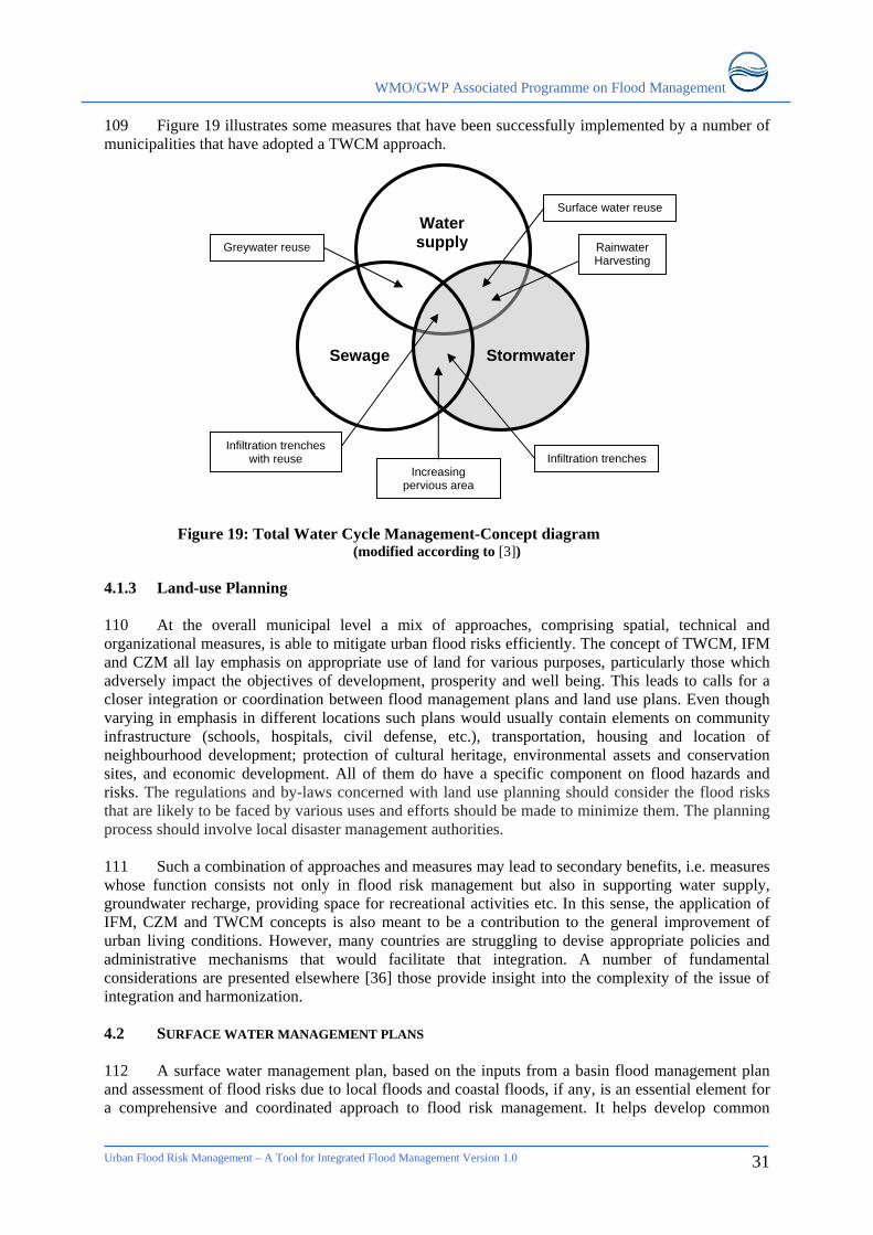
WMO/GWP Associated Programme on Flood Management
109 Figure 19 illustrates some measures that have been successfully implemented by a number of municipalities that have adopted a TWCM approach.
Water supply
Stormwater Sewage
Greywater reuse
Infiltration trenches Increasing
pervious area
Infiltration trenches with reuse
Surface water reuse
Rainwater Harvesting
Figure 19: Total Water Cycle Management-Concept diagram
(modified according to [3]) 4.1.3 Land-use Planning 110 At the overall municipal level a mix of approaches, comprising spatial, technical and organizational measures, is able to mitigate urban flood risks efficiently. The concept of TWCM, IFM and CZM all lay emphasis on appropriate use of land for various purposes, particularly those which adversely impact the objectives of development, prosperity and well being. This leads to calls for a closer integration or coordination between flood management plans and land use plans. Even though varying in emphasis in different locations such plans would usually contain elements on community infrastructure (schools, hospitals, civil defense, etc.), transportation, housing and location of neighbourhood development; protection of cultural heritage, environmental assets and conservation sites, and economic development. All of them do have a specific component on flood hazards and risks. The regulations and by-laws concerned with land use planning should consider the flood risks that are likely to be faced by various uses and efforts should be made to minimize them. The planning process should involve local disaster management authorities. 111 Such a combination of approaches and measures may lead to secondary benefits, i.e. measures whose function consists not only in flood risk management but also in supporting water supply, groundwater recharge, providing space for recreational activities etc. In this sense, the application of IFM, CZM and TWCM concepts is also meant to be a contribution to the general improvement of urban living conditions. However, many countries are struggling to devise appropriate policies and administrative mechanisms that would facilitate that integration. A number of fundamental considerations are presented elsewhere [36] those provide insight into the complexity of the issue of integration and harmonization. 4.2 SURFACE WATER MANAGEMENT PLANS 112 A surface water management plan, based on the inputs from a basin flood management plan and assessment of flood risks due to local floods and coastal floods, if any, is an essential element for a comprehensive and coordinated approach to flood risk management. It helps develop common
Urban Flood Risk Management – A Tool for Integrated Flood Management Version 1.0
31

WMO/GWP Associated Programme on Flood Management
Urban Flood Risk Management – A Tool for Integrated Flood Management Version 1.0
32
understanding of flood risk issues among all stakeholders at various administrative levels. These assessments may require detailed modelling of the flood processes with comprehensive understanding of historical floods, surface and sub-surface drainage systems and interaction between floods from different sources. 113 The resulting pan should elaborate:
• Land allocation for various purposes • Strategies for most cost-effective flood risk reduction • Responsibilities of various institutions in flood risk management • Mechanism for emergency response to minimize impacts of residual risks • Mechanisms for bearing the cost of risk reduction and sharing/transferring risks
114 The elaboration of flood risk management plans as well as the implementation of respective measures should not be considered as one-time task but as a continuous learning process. In order to constantly improve policies and measures it is essential to regularly monitor and evaluate them. Because the specific hydrological, socio-economic, political and ecological circumstances vary from city to city, this is the only viable means of identifying best practices in the long run. The evaluation of measures is a fundamental step in flood risk management and is closely linked to the reassessment of risk. The repetition of risk assessments after the implementation process allows proper judgement of the effectiveness of each specific measure and the identification of those components of risk which require further mitigation. 4.3 ORGANIZATIONAL REQUIREMENTS 4.3.1 Present shortcomings 115 Six categories of inefficiencies are generally noticed in dealing with urban floods. These are related to:
1. Comprehensive Risk assessment; 2. Factoring risks in development planning; 3. Coordination among different institutions; 4. Lack of information sharing; 5. Disintegrated investment decisions; and 6. Lack of consultation with stakeholders
116 No single organisation is generally charged with or has an incentive to carry out a comprehensive assessment of the risks of flooding. Individual organisations typically conduct their own independent work on mapping and modelling flood risk in relation to their own assets, with no one taking a strategic or holistic overview. There is no single repository or formal reporting of historic flood incidents, except perhaps insurance companies, who rarely share this information because it is commercially sensitive. Decisions for new development (properties and infrastructure) are often taken without a full understanding of the risks of flooding. Consideration of new developments on a case-by-case basis can ignore cumulative stormwater effects on flood risks. As organisations manage different parts of the urban drainage infrastructure, they make investment decisions based on a limited cost-benefit analysis that rarely considers the wider drainage issues. The sum total of these individual and piecemeal investment strategies is unlikely to produce the most effective solution. 4.3.2 Institutional arrangements 117 Applying the principle of management as close to communities as possible, the management of flood risks should be undertaken by municipalities. The organizational focus of urban flood risk management is therefore the municipality. The performance of the municipality is the key factor for
WMO/GWP Associated Programme on Flood Management
the success or failure of flood risk management plans. Basically, there are three main factors which are decisive for the municipal performance. 118 First, the organizational structure which is supposed to clearly assign tasks and responsibilities to the various municipal departments and other involved institutions. Both, the overlapping of responsibilities as well as gaps of non-responsibility, within institutions or between them, hinder effective urban flood risk management. Local authorities are best placed to cope with flooding from small streams whose catchment areas lie almost entirely within the built-up area but they may need to interact with basin organization and national agencies responsible for monitoring and assessment of hydro-meteorological hazards and risks. Cities faced with coastal flooding from the sea, or by a combination of high tides and high river flows from inland, have to work closely with both river basin and coastal zone management authorities. 119 Of equal importance to task assignment is the cooperation between the responsible institutions. Urban floods are indeed a cross-cutting issue affecting many different aspects of urban life. Therefore, it is essential for the successful management of urban flood risks that all concerned institutions cooperate with each other beyond their sector or disciplinary boundaries. This is a fundamental principle of the concept of Integrated Flood Management (IFM) which deserves particular attention in context of cities which are subdivided in different municipalities as well as in cities where the institutional setting requires the involvement of national authorities in flood management. However, if organizational structures are not led by competent and accountable leaders they are likely to exclude the concerns of some people, thereby increasing their vulnerability. If the latter applies to municipal authorities it is referred to as “bad urban governance”, which is marked by the inability or unwillingness of authorities to support their hazard prone population during emergency situations as well as in terms of preparedness and recovery. 120 The second factor refers to the content of urban flood management policies and plans themselves. The previous chapters gave an overview of some aspects and considerations that should form part of flood risk management plans. At this point it has to be underlined again that such plans have to state clear and overall workable targets and measures. Only if these principles of clarity and workability are realized in plans they will make a valuable contribution to municipal performance. 121 Finally the process of implementing plans is the decisive final step. The success of implementation depends on one hand on the quality of plans, while on the other hand it depends on the municipality’s ability to enforce plans in terms of financial and organizational capacities. Whereas the possibilities of municipalities to influence the general availability of funds is usually quite limited, it is definitely up to the municipality to decide upon how the available budget is spent and how measures are implemented. This is closely linked to principles of good urban governance which comprise transparency, accountability, participation, efficiency and equity. These basic principles strongly support the effectiveness and sustainability of municipal activities. 4.4 PARTICIPATORY PLANNING OF MEASURES 122 All the concepts that underpin the urban flood risk management framework are based on participatory principles. Traditionally, flood control has been driven by top-down decision making. Following the hierarchical structure of administrative systems, flood control measures are planned without the participation of the affected communities and other stakeholders. In many cases this results in unsustainable measures which don’t meet the needs of relevant stakeholders. In more severe cases exclusive top-down decision making even can lead to serious conflicts.
Urban Flood Risk Management – A Tool for Integrated Flood Management Version 1.0
33
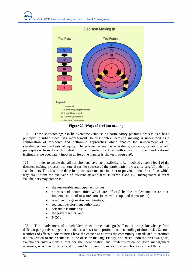
WMO/GWP Associated Programme on Flood Management
Urban Flood Risk Management – A Tool for Integrated Flood Management Version 1.0
34
Figure 20: Ways of decision making 123 These shortcomings can be overcome establishing participatory planning process as a basic principle in urban flood risk management. In this context decision making is understood as a combination of top-down and bottom-up approaches which enables the involvement of all stakeholders on the basis of equity. The process where the aspirations, concerns, capabilities and participation from local household to communities to local authorities to district and national institutions are adequately input in an iterative manner is shown in Figure 20. 124 In order to ensure that all stakeholders have the possibility to be involved at some level of the decision making process it is crucial for the success of the participation process to carefully identify stakeholders. This has to be done in an inclusive manner in order to prevent potential conflicts which may result from the exclusion of relevant stakeholders. In urban flood risk management relevant stakeholders may comprise:
• the responsible municipal authorities; • citizens and communities which are affected by the implementation or non-
implementation of measures (on site as well as up- and downstream); • river basin organizations/authorities; • regional development authorities; • scientific institutions; • the private sector; and • NGOs
125 The involvement of stakeholders meets three main goals. First, it brings knowledge from different perspectives together and thus enables a more profound understanding of flood risks. Second, members of affected communities have the chance to express the community’s needs and to promote the integration of their demands in the decision making. Finally, and based upon the first two goals, stakeholder involvement allows for the identification and implementation of flood management measures, which are effective and sustainable because the majority of stakeholders support them.
WMO/GWP Associated Programme on Flood Management
126 Although a consensus among all stakeholders can rarely be found, especially in cities where spatial resources for flood mitigation are scarce, experiences show that seriously practiced participation is decisive for the mediation of conflicts. In urban areas, although there may be advantages of concentration of stakeholders as well as the medium of communication, there is always a shortage of time for participation in such activities. Particularly, in sub-urban areas, people have little time to spare from their livelihood engagements and time they perforce spent in travelling to their place of work. Special means have to be found to make use of the advantages and address the shortcomings. Further discussion on the constraints of stakeholder involvement and how representative form of participation can be achieved are available elsewhere [37]. 127 In many countries, the private sector contributes significantly to the creation of physical and industrial infrastructure. In association with relevant national agencies, efforts must be made to develop and establish improved techno-legal procedures for disaster-resilient infrastructure. Private sector actors can particularly contribute to building resilient economies, infrastructure and communities through the following disaster risk management activities:
• hazard and risk assessments • awareness generation • preparedness training and drills • efficient logistics for rescue and relief operations • provision of trained engineers, architects and building artisans • development and application of cost-effective hazard-resistant technologies • involvement in the development of all-hazard warning and monitoring systems • development of risk transfer instruments
Urban Flood Risk Management – A Tool for Integrated Flood Management Version 1.0
35
WMO/GWP Associated Programme on Flood Management
Urban Flood Risk Management – A Tool for Integrated Flood Management Version 1.0
36
5. CONCLUSIONS AND RECOMMENDATIONS 128 Complexity of flood risk evolution process requires a clear understanding of the construct of the typology of various components of flood risks and the factors that mitigate or abate them. Many sectoral development processes have profound influence on their management. The complex interaction between development processes and flood risk genesis requires a clear conceptual framework which is supported by appropriate organisational and institutional mechanisms to develop and implement surface water management plans. Following issues need to be addressed while developing and implementing such plans.
• Urban flood risks are more than flood waters; risks result from a combination of components, comprising hazard, exposure and vulnerability. The recognition of these components facilitates the understanding of flood risks because it underlines that only the combination of natural and human factors create flood risks.
• Municipalities are well advised to spend adequate resources for comprehensive flood risk assessments. Only if there is data which clearly indicates which neighbourhoods are most at risk, successful measures can be planned. Information about existing flood risks forms the basis for decision-making.
• Community participation in flood risk assessment as well as in planning and implementation of risk management measures is key for the success of flood risk management plans. Meeting the needs of stakeholders is only possible if stakeholders are involved in the decision-making process.
• Flood management measures have to be planned across administrative and sectoral boundaries. Institutionalized links between concerned authorities facilitate cooperative planning.
• Up- and downstream aspects have to be factored in urban flood risk management. Too extensive drainage may constitute a severe flood hazard for downstream settlements. Finding an adequate compromise between stormwater drainage and source control needs profound consideration and consultation with all stakeholders.
• Successful urban flood risk management is only possible if different measures, comprising structural and non-structural, spatial and organizational, are combined.
• The implementation of multiple purpose measures enables municipalities to achieve multiple goals (flood mitigation, water supply, space for recreational activities, groundwater recharge, improvement of urban aesthetics etc.).
• Recognizing sustainable, flood aware urban planning as the most promising strategy for successful flood risk management in the long run. Flood aspects have to form an integral part of urban planning.
• Monitoring and evaluation of implemented measures enable the identification of best practices under the specific circumstances and help to constantly improve flood risk management plans.
WMO/GWP Associated Programme on Flood Management
REFERENCES [1] MunichRe, 2005. Megacities – Megarisks: Trends and Challenges for Insurances and Risk
Management, http://www.munichre.com/publications/302-04271_en.pdf [2] Crichton, D., 1999. The Risk Triangle. In: Ingleton, J. [Ed.]. Natural Disaster Management.
Tudor Rose. 102-103. [3] Glossary of the UN International Strategy for Disaster Reduction 2004,
http://www.unisdr.org/eng/library/lib-terminology-eng%20home.htm [4] APFM, 2006. Social Aspects and Stakeholder Involvement in Integrated Flood Management,
http://www.apfm.info/pdf/ifm_social_aspects.pdf [5] http://www.nrcs.usda.gov/technical/stream_restoration/Images/scrhimage/chap3/fig3-21.jpg [6] http://www.uwsp.edu/geo/faculty/ritter/images/lithosphere/fluvial/urban_hydrograph.jpg [7] Intergovernmental Panel on Climate Change, 2007. Impacts, Adaptation and Vulnerability.
Summary for Policymakers, http://www.ipcc.ch/pdf/assessment-report/ar4/wg2/ar4-wg2-spm.pdf
[8] IPCC Working Group II, 2007. [9] UNCHS, 2002, The State of the World Cities Report 2001. United Nations Publications. [10] UN Department of Economic and Social Affairs, 2005. World Urbanization Prospects,
http://www.un.org/esa/population/publications/WUP2005/2005wup.htm [11] Anthoff, D. et al., 2006, Global and Regional Exposure to Large Rises in Sea-Level: A
Sensitivity Analysis. Tyndall Centre for Climate Change Research, Working Paper 96. [12] IHDP, 2005, Science Plan - Urbanization and Global Environmental Change. IHDP Report No.
15, http://www.ihdp.uni-bonn.de/html/publications/reports/UrbanizationSciencePlan.pdf [13] Wisner, B. et al. 2004. At Risk. Natural hazards, people’s vulnerability and disasters.
Routledge. [14] Parker, D.J. [Ed.], 2000. Floods, Volume I and II. Routledge. [15] http://www.adrc.or.jp/publications/Venten/HP/herath4.jpg [16] APFM, 2007. Economic aspects of Integrated Flood Management,
http://www.apfm.info/pdf/ifm_economic_aspects.pdf [17] Gesellschaft für technische Zusammenarbeit (GTZ), 2004. Risk Analysis – A Basis for Disaster
Risk Management, http://www.proventionconsortium.org/themes/default/pdfs/CRA/GTZ2004_meth.pdf
[18] Bollin, C. and Hidajat R. Presentation on Community Based Disaster Risk Index – Experiences from Indonesia, www.adrc.or.jp/unu/UNU%20Indicator%20Kobe.ppt
[19] Swiss Civil Protection. [20] Maksimovic, C., 1996, Measurements of Water Quantity in Urban Areas. In: WMO, Rain and
Floods in our Cities – Gauging the Problem. WMO/TD – No. 741. [21] Municipal Program Development Branch, 1999. Stormwater Management Guidelines for the
Province of Alberta, http://environment.gov.ab.ca/info/library/6786.pdf [22] DeGroot [Ed.], 1982. Stormwater Detention Facilities. ASCE Conference Proceedings.
Henniker. [23] UNHABITAT, 2005. Rainwater Harvesting and Utilisation – Book 1: Policy makers.
http://www.unhabitat.org/pmss/getPage.asp?page=bookView&book=2058,
Urban Flood Risk Management – A Tool for Integrated Flood Management Version 1.0
37
WMO/GWP Associated Programme on Flood Management
Urban Flood Risk Management – A Tool for Integrated Flood Management Version 1.0
38
UNHABITAT, 2005. Rainwater Harvesting and Utilisation - Book 2: Beneficiaries & Capacity Building, http://www.unhabitat.org/pmss/getPage.asp?page=bookView&book=2059
[24] Faisal, I.M. ; Kabir M.R.; Nishat, A. (1999). Non-structural flood mitigation measures for Dhaka City. In: Urban Water 1 (1999) 145 – 153.
[25] Municipal Program Development Branch, 1999. Stormwater Management Guidelines for the Province of Alberta, http://environment.gov.ab.ca/info/library/6786.pdf
[26] Moll, R., 2005. Co-operation within Europe on flood management and spatial planning. In: Szöllösi-Nagy, A. and Zevenbergen, C. [Eds.]. Urban Flood Management. A.A. Balkema Publishers.
[27] Stephenson, D., 2002, Integrated flood plain management strategy for the Vaal. In: Urban Water 4 (2002) 425 – 430.
[28] Burby, R.J., 2000. Land-use Planning for Flood Hazard Reduction: the United States Experience. In: Parker, D.J. [Ed.]. Floods, Volume II. Routledge.
[29] FLOWS interactive learning package for sustainable flood management, http://flows.wb.tu-harburg.de/index.php?id=340
[30] UNESCO, 1995. Fighting Floods in Cities. Training Material. [31] APFM, 2006. Legal and Institutional Aspects of Integrated Flood Management,
http://www.apfm.info/pdf/ifm_legal_aspects.pdf [32] SwissRe, 1998, Floods - an insurable risk?
http://www.swissre.com/resources/50b7ff80455c7c31b5b0bf80a45d76a0-floods.Paras.0001.File.pdf
[33] APFM, 2004. Integrated Flood Management – Concept Paper , http://www.apfm.info/pdf/concept_paper_e.pdf
[34] Chanan, A. and Woods, P., 2005. Managing the Water Cycle in Sydney Metropolitan: Local Governments Do Matter! In: Khan, S.J., Schäfer, A.I. and Muston, M.H. [Eds.]. Integrated Concepts in Water Recycling, http://www.uow.edu.au/science/chem/aquarec/icwr/x/Chanan.pdf
[35] Pauleit, S. and Duhme, F., 2000, Assessing the environmental performance of land cover types for urban planning. In: Landscape and Urban Planning 52, 1-20.
[36] APFM, 2008, Land Use Planning for IFM in Flood Management Tools Series. [37] UNHABITAT, 2001. Tools to Support Participatory Urban Decision Making.
http://www.unhabitat.org/pmss/getPage.asp?page=bookView&book=1122