urban resilient design guidelines - bezalel academy of ... · urban resilient design guidelines –...
TRANSCRIPT

Urban Resilient
Design Guidelines


Urban Resilient
Design Guidelines
December 2014

Desurbs, EU, 7FP, Bezalel - All right reserved © 2014
This project has received funding from the European Union’s Seventh Framework Programme for research, technological development and demonstration under grant agreement no 261652

Preface
What is the DESURBS Project?
DESURBS is a research-based project, which is tasked with producing
relevant and useable products for built environment and design
professionals to realise more resilient and secure design for urban
spaces. DESURBS stands for Designing Safer Urban Spaces. It has
developed tools for built environment and design professionals to use
to understand, identify, and address security risks affecting the spaces
they are involved in planning, designing and managing.
Who funds the DESURBS project?
DESURBS is part funded by the European Commission. It is funded
through the FP7 programme as a capability project under the 10.2
Security of infrastructures and utilities area of research as part of the
SEC-2010.2.3-1 Planning, (re)design, and (re)engineering of urban areas
to make them less vulnerable and more resilient to security threats call.
(Sourced from the DESURBS website www.desurbs.eu)
Our Supporters
The initiation of the DesUrbs project in 2011 was a challenge in a period that was just beginning to focus on the integrated management of natural hazards and security threats. In opening up the discussion to end-users on a local and national level during the four year project we had numerous meetings and discussions with end-users and developed a working relationship with many professionals who provided the Bezalel researchers with expert knowledge and shared their experiences. In recognizing the many institutions and individuals from both the national and local levels in Israel who generously gave of their time, we are hopeful that a basis for continuing collaboration has been created for a greater understanding and concern for the resilient city.
In addition to the many contacts, we would like especially to thank:Ashdod Municipality - Arieh Itah, Director of Emergency and Security City of Ashdod; Geological Survey of Israel – Dr Rivka Amit , Dr Amos Salmon;Home Front Command - Alex Blekhman, Head of Development Section, Michael Vatenmacher, Head of Protective and S&R (Search and Rescue) Engineering Section;IDF Emergency Hospital Preparedness for Mass Causality and Trauma Unit, Shaare Zedek Medical Center - Dr. Ofer Merin, Director, Trauma Unit, Cardiovascular Surgery, Chief- IDF Field Hospital (Res.);Israel Antiquities Authority - Michael Cohen, International Project Coordinator, Conservation Department;Israel Police – Dan Fisher, Chief superintendent, Head of Strategic & Planning Section;Jerusalem Municipality - Naomi Zur, Former Deputy Mayor, Ofer Manor, City Architect, Menahem Helman, MALAM GIS Department Manager, Shaked Shavit, Security Systems Manager of the Emergency & Safety Division, Itzik Nidam, Manager of the Emergency & Safety Division, Moshe Derei, Deputy Manager of the Emergency & Safety Division;Jerusalem Transportation Master Plan Team - Nadav Meroz, Managing Director, Danny Givon, Model & Planning Unit, Galit Levy, GIS Expert;Joint Distribution Committee – Judy Amit;Magen David Adom - Chaim Rafalowski, Disaster Management and EU Projects Coordinator; Ministry of Public Security - Dr. Besora Regev, Head of Research Department, Division of Policy and Strategic Planning, Shai Amram- Research Department, Division of Policy and Strategic Planning, Yonatan Ilan, GIS, Ronel Harmatz- Head of Community Crime Prevention & Knowledge Development at Metzila;Ministry of Interior - David Pilser, Director, Division of Planning & Building Guidelines & Regulations;Yaron Turel, Senior Director Development Methodologies ;National Steering Committee for Earthquake Preparedness - Dr Avi Shapira, Chair, Yael Kligman;Skyline Software Systems- Arik Katz, Senior Vice President, Eylon Sirotkin, Director of Professional Services;Tel Aviv Municipality - Aviad Heilbrun, GIS Specialist and Project Manager, Hila Lubanov, Strategic Planning Unit, the Engineering Department, Michal Ritte Gafny, GIS Project manager, Yair GIS Department, IT Division;TerraVision Ltd.- Meir Most ,CEO and Asaf Roz, CTO;
The development of the security products brought together yet another group of professionals including RT-LTA Ltd, Israel - Rafi Shmueli and Humedica, Germany – Rafael Marcus and Eli Maimon, LED lighting expert - all contributing to the creation of HopeSpot.
Our main dissemination event held in Jerusalem in May, 2014 was attended by over 70 people, including representatives of the DESURBS consortium, UNISDR and ICOMOS who provided insights and comments on the DESURBS work process. Special thanks to Jerry Velasquez of the Resilient Cities Programme, Rohit Jigyasu of the ICOMOS International Scientific Committee on Risk Preparedness for their contributions and to Elizabeth Longworth and Abhilash Panda at the UNISDR head office in Geneva who encouraged us to integrate the outcomes in the UNISDR Resilient Cities programme. Professor Claudio Modena accompanied the Israel Antiquities Authority and members of the EU COST Action TU1203 ‘Crime Prevention through Urban Design and Planning‘ contributed valuable comments.
Acknowledgements

Bezalel Academy of Arts and Design The DESURBS project at Bezalel integrated many departments in the under-graduate and post-graduate programmes. In addition to the security products that were developed and tested, the Urban Resilient Design Guidelines are a synthesis of the methodologies and approaches that were studied during the past 48 months. DESURBS provided an inter-disciplinary platform coordinated by the Graduate Program in Urban Design with the MDes Design Management Program and the Industrial Design Department, supported by the Departments of Visual Communication and Screen-Based Arts.
The Graduate Program in Urban Design focused on the Urban Resilient Design Guidelines, which used the GIS expertise of Tamar Ganor, supported by Rachel Singer and architect Renanit Avitan-Fein, MUrbDes students. A project of this capacity and time naturally involved many faculty members notably Hod Fleishman, Prof David Guggenheim, Dr Meirav Gutman, Dr Moshe Hirsch, Dr Nati Marom and Dr Dalit Shach-Pinsly, who all gave major contributions each in their particular field. The heads of the two graduate programmes, Prof Zev Druckman and Michal Eitan, as well as Haim Parnas of the Undergraduate Industrial Design program provided much needed departmental support. We also wish to thank Professor Laura Vaughan, Bartlett School of Architecture, UCL and Raanan Gabay for their input on Space Syntax. We look forward to expanding and integrating Space Syntax into understanding resilient cities in a more comprehensive way in future research.
DesUrbs Project faculty developing security products were ably headed by Elad Persov, Head of the MDes Design Management Program and with the end-user approach developed by anthropologist Dr. Yona Weitz. Eran Lederman, from the Industrial Design Program, guided the undergraduate students in developing their products over and above their prototype designs. Three important products were developed including CityZen by Daniel Glazman, Yuval Tirosh, Adam Zehavi, and Oded Gov, CityTalk by Hanna Spaander and HopeSpot by Hadas Ilani, Tamir Niv and Idan Raizberg.
The video team in the Department of Visual Communication included the lecturers, Eran Yuval, Head of Motion Design Program and Erik Lerer, who guided the student clips co- creators Arkady Kravchouk and Oleg Morozov for CityZen and HopeSpot; Sohini Tal a student from the Screen-based Arts Department prepared the graphic icons and video-clip for the Urban Design Resilient Guidelines. We benefited from logistic support of Lary David, Michal Ashkenazi and Naomi Yagan together with our coordinating students Alex Elgin, Tal Tomer and Yael Cohen.
Our Consortium:
In addition we would like to recognise the support and dialogue that the Bezalel team had with all our consortium members.
| 1 | Research Management AS | 2 | Loughborough University | 3 | University of Warwick
| 4 | Hebrew University of Jerusalem | 5 | Technical University of Crete
| 6 | Centre Internacional de Metodes Numerics en Enginyeria | 7 | University of Southampton
| 8 | Bezalel Academy of Arts and Design
All in all, over 50 key Israeli professionals, and 35 faculty and students were directly involved in the DESURBS project during its four-year Bezalel activity enriching our research experiences, while the dissemination events provided exposure to some 200 professionals and academics. We look forward to continuing our cooperation and expanding our horizons with the importance and recognition of designing safer urban cities.
Prof Mike Turner- UNESCO Chair in Urban Design and Conservation Studies Graduate Program in Urban Design on behalf of Bezalel DESURBS

Bezalel Academy of Arts and DesignThe Urban Resilient Design Guidelines were developed in the Graduate Program in Urban Design with the close cooperation of the MDes Design Management Program and the Industrial Design Department and were supported by the Departments of Visual Communication and Screen-Based Arts.
Team Leader
Prof Mike Turner-UNESCO Chair in Urban Design and Conservation Studies, Graduate Program in Urban Design
Urban Resilient Design Guidelines – Graduate Program in Urban Design
Ms. Tamar Ganor, MA, MEd, GIS Specialist
Ms. Rachel Singer, MUrbDes student
Ms. Renanit Avitan-Fein, Architect
During the project, faculty members Hod Fleishman, Dr Meirav Gutman, Prof David Guggenheim, Dr Moshe Hirsch, Dr Nati Marom and Dr Dalit Shach-Pinsly, all gave major contributions each in their particular field.
DesUrbs Project Faculty
Mr. Elad Persov, Head of MDes - Design Management Program,
Dr. Yona Weitz, Anthropologist- Design Management Program,
CityZen
Mr. Daniel Glazman, MDes student,
CityTalk
Ms. Hanna Spaander, MDes student,
HopeSpot
Mr. Eran Lederman, Senior Lecturer, Industrial Design Program,
Ms. Hadas Ilani, Mr. Tamir Niv and Mr. Idan Raizberg, MDes students
Loughborough University and the University of Warwick The Integrated Security Resilience Decision and Support Framework which provides a critical component of the guidelines was developed within the consortium by team members: Dr. Lee Bosher and Dr. Ksenia Chmutina from Loughborough University, and Prof. Jon Coaffee, Dr. Rob Rowlands, Jonathan Clarke, Architect from the University of Warwick
The Tel Aviv case-study maps and information were generously provided by the Tel Aviv Municipality.
Contributors

The Role of the Planning Professional in Designing Safer Urban Spaces...............................................................................2
How to Use the Guidelines.................................................................................................................................................................................3
1. Introduction...........................................................................................................................................................................................................4
2. Goals.........................................................................................................................................................................................................................6
3. Review of literature and background.......................................................................................................................................................7
4. Mapping for Resilience...................................................................................................................................................................................9
4.1 DesUrbs Security Products.....................................................................................................................................................11
4.1.1 CityZen.......................................................................................................................................................................12
4.1.2 HopeSpot................................................................................................................................................................13
4.1.3 CityTalk......................................................................................................................................................................14
4.2 Recommended Layers for Urban Resilient Design....................................................................................................15
4.2.1 Urban Environment...........................................................................................................................................17
4.2.2 Population.............................................................................................................................................................21
4.2.3 Emergency Services........................................................................................................................................23
4.2.4 Natural Hazards.................................................................................................................................................26
4.2.5 Crime.......................................................................................................................................................................29
4.2.6 Planned Events....................................................................................................................................................31
4.2.7 Social Media..........................................................................................................................................................32
5. Using the Integrated Security & Resilience Framework to support urban design decisions...............................33
5.1 Stage 1: Mapping hazards and threats- what are the hazards/threats to the site?.............................33
5.2 Stage 2: Identifying and Assessing the vulnerability of urban spaces to specific hazards/ threats.....35
5.3 Stage 3: Determine the risk....................................................................................................................................................39
5.4 Stage 4: Identifying ways to reduce risk..............................................................................................................................41
5.5 Stage 5: Prioritize risk reduction- Incorporating DesUrbs Security Products...................................................... 42
6. Case Study: The Jerusalem Marathon.....................................................................................................................................................43
7. Conclusions.........................................................................................................................................................................................................45
8. Appendix.............................................................................................................................................................................................................46
8.1 Review of a Selection of Urban Resilience Manuals................................................................................................46
9. Bibliography.........................................................................................................................................................................................................51
Contents

The Role of the Architect/Planner in Designing Safer Urban Spaces
In urban design a multi-disciplinary team of planning professionals1 that includes: planners, architects, security consultants, engineers and local authorities, is required to analyze an area or neighborhood and decide its future. These critical decisions extend beyond the physical character, land uses, types of construction, height, transportation infrastructure, amount and type of institutions, and have long term implications for socio-economic and environmental sustainability. Much of the contemporary discussion on urban design is currently focused on the topics of resilient cities and Disaster Risk Reduction (DRR), and architects and planners are primary stakeholders in the construction sector and serve a vital role in shaping safer spaces (Chmutina, Ganor & Bosher, 2014). It is therefore imperative that this sector understand the different components that contribute to urban resilience and DRR, by providing an integrative approach. Part of the planning professional’s role is to make recommendations to decision-makers and promote public awareness about resilience. Integrating resilience principles into the planning process at the earliest planning stages ensures better results.
The initial programming phase should reflect the whole process of policy and design and stress a comprehensive view. The uniqueness of urban design lies in its integrative focus, rather than on a particular structure or single area and ideally has an overarching environmental attitude. Designing large areas requires attention to many factors, be it the nature of the region itself; i.e. center city, urban, semi-urban, suburban, natural features, in addition to socio-economic municipal factors that comprise the city management and include police and community managers. The types of institutions needed at present and in the future influence the character of the neighborhood. Planning must address these issues in order to fully fill the needs of the community. The proliferation of information and lack of integration often prevents a wide-ranging and holistic approach in favor of site specific planning that often fails to address broader issues.
Part of the planning professional’s role is to make recommendations to decision-makers and promote public awareness about resilience. Integrating resilience principles into the planning process at the earliest planning stages ensures better results.
Cities today are primarily the product of top-down design and planning. Planning cities to incorporate values of safety should not solely focus on the physical components; they must extend to the economic, environmental and social aspects as well as including the cultural component. It is therefore vital to provide and access a wide range of information needed in the decision-making process of planning and design. Different types of information are needed to understand phenomena that affect resilience as well as trends that impact the area slated for planning. This manual provides an introduction to mapping methods and parameters that can aid in planning for resilience and DRR.
1. The term ‘planning professionals’ in the guidelines text refers to planners, architects, security consultants, engineers and local authorities.
Paved pedestrian street, Jaffa St., in the revitalized Jerusalem downtown (Photo: Renanit Avitan Fein)
- 2 -

How to Use the Urban Resilient Design Guidelines (URDG)
The DesUrbs Urban Resilient Design Guidelines proposes a GIS (Geographical Information System) based methodology based on layers that apply the Integrated Security and Resilience (ISR) design framework to identify vulnerabilities and improve urban spaces through a stage-by-stage process.
that threaten urban populations and environments. These tools were designed to aid in creating and maintaining safe spaces on a daily basis and during emergency events.
At a site-specific level of planning, once the recommended layers (detailed in section 4.1) have been collected the Integrated Security & Resilience (ISR), a generic, decision-support framework developed to consolidate security and resilience approaches suitable for urban spaces can be applied. The ISR framework comprises five key stages that are primarily derived from an international standard for risk management (British Standards Institution, 2011; 2009).
The maps that result at the end of this process will show the planner and decision-makers strengths and vulnerabilities in the vicinity and potential long-range impacts. Using these tools planners and decision makers can reach better-informed conclusions for the management of the economic, social and environmental implications during both routine and emergency events, while linking them to cultural norms.
The guidelines can be read according to sections of interest, as such minor repetitions will appear for the reader of the entire guidelines.
Watch the Urban Resilient Design Guidelines clip- http://vimeo.com/93713153
Evaluation of the effectiveness of the industrial design products in the creation of safer urban spaces
These guidelines aim to highlight various types of information available to support resilient planning and stress the importance of analyzing different data layers to create a comprehensive picture of the existing situation. In these guidelines we detail a number of outputs from the DESURBS project and demonstrate recommendations for optimal use of new industrial design security products in the mapping process.
A critical aspect that the guidelines stress is that planning for resilience should be applied as early as possible in the design process. As resilience principles are applied later they become less effective and more expensive.
This approach promotes the integration of information from different sources that is often not presented together. Geographic, social, environmental, economic, and quantitative data can provide a comprehensive cross section when properly analyzed and utilized towards the creation of “smart cities” (see Tel Aviv: “World’s Smartest City Box – p. 8). We advocate that this material be incorporated to aid in the process of managing the city, beyond planning and building regulations, environmental impact assessments and reference areas. The combination of information from formal and informal sources as well as intangible heritage will aid in the design of an inclusive solution that encourages sustainable development and constitutes a sound basis for resilient cities.
The URDG proposes a framework to help map for resilience:
• Disasters/ unplanned events hit the cities in many forms, natural, industrial, terror and crime.
• Crowded areas and planned events need particular consideration
Preparation for these events needs to be considered before, during and after they occur. To cope with these challenges the Bezalel DESURBS team has developed a number of innovative products that contribute to the creation of safer urban environments, including the HopeSpot Balloon, CityZen and CityTalk. These tools address a wide range of possible events (crime, terror, accidents, natural hazards and inclusive planning)
- 3 -

1. Introduction
City planning is a continuous process that relies on accessible information by all stakeholders. Plans are tools for managing the city and its component parts and not merely a matter of deciding land usage rights. Diverse sources of data with regard to the planned area can provide designers with the in-depth information they need to consider all relevant issues that arise when planning the city. Instead of planning solely for the population or a single issue it is possible to plan for multiple factors and thus address a wider range of problems prevalent in the city and the community. Case examples and document repositories can provide a wealth of information of best practice examples, a sample of which can be sourced at the DesUrbs Decision System Support Portal: http://desurbs.it-innovation.soton.ac.uk .
What is urban resilience?
This term has different meanings for different users in a range of disciplines, and is used both in economics and engineering. The source of the term derives from ecology and has traditionally been used to describe ecosystems. The degree of resilience reflects the ability of an ecosystem to cope with stress and interference from external sources.
The term urban resilience refers to several aspects:
1. Preparedness and mitigation for planned events and hazards.
2. Creating emergency plans for events that include: technological failures, natural hazards and terrorist attacks.
3. The degree of institutional robustness charged with protecting key infrastructure.
These aspects are expressed in various systems such as DRR (Disaster Risk Reduction) designed to promote vitally important information to strengthen individuals, communities and institutions (Bosher, 2014).
Resilience combines the different phases of disaster cycles, including: mitigation, preparedness, response, recovery and adaptation (O’Brien and Paul Read, 2005). In the last decade the rhetoric of resilience and its underpinnings have slowly infused a variety of policymaking circles and a wide range of disciplinary areas (Coaffee, 2013) becoming more inclusive by relating to both the
“The ability of a system, community or society exposed to hazards to resist, absorb, accommodate to and recover from the effects of a hazard in a timely and efficient manner, including through the preservation and restoration of its essential basic structures and functions.” (UNISDR, 2007)
physical and social components of the city (Coaffee and Bosher, 2008). Urban resilience is a proactive approach that provides both a lens through which we can analyze the different problems that cities face as well as providing a framework with space for solutions. Several phases in the evolution of urban resilience policies have been noted, initially reactive, expanding to take preventive actions and then followed by an attempt to incorporate aspects of resilience into daily routine, through the anticipation of shocks on multiple levels. The current approach sees the path to resilience as inclusive, incorporating the individual, institutions and neighborhoods in order to achieve the broadest possible form of participation (Coaffee, 2013), with an emphasis on culture as driver for resilience.
Based on the three pillars of sustainability and extending from the physical infrastructures to include the socio-economic and environmental, the UNISDR broadened the definition of resilience as: “the ability of a system, community or society exposed to hazards to resist, absorb, accommodate to and recover from the effects of a hazard in a timely and efficient manner, including through the preservation and restoration of its essential basic structures and functions.” (UNISDR, 2007)
As it is often not possible to prevent disasters, governments and NGOs are aiming to increase the resilience of communities and societies through a combination of research, policy, and program development as well as through management and education. The UNISDR has embarked on an ambitious global campaign encouraging resilience in cities called “Making Cities Resilient” that is active in over 2,400 cities around the world.
Even within communities that have a high level of resilience there are groups with fewer tools to cope with disasters and tend to be disproportionately impacted: including women, children, the elderly and low-income groups (Maguire and Hagan, 2007). These particular characteristics of social behavior need to be studied to achieve a more durable approach to disasters by inculcating day-to-day reactions to ‘everyday’ incidents.
As the planner approaches the urban design process they rely on various sources of information. Urban designers encounter big
- 4 -

For the latter, in the design of urban space it is necessary to identify places of importance in collective memory and places of gathering that have an important role in shaping safe places.
Examining and cross checking parameters by groups (such as natural features, population, services in an emergency, built environment) is dependent on a number of variables including expectations, research, intentions of the developer and information received from the authorities.
data issues, though not always prepared with the appropriate tool set to evaluate, manage and prioritize the relevant data associated with the urban environment while also promoting values relating to sustainability and culture.
Culture has been added to the three pillars of sustainability and this in its turn has strengthened the need to understand the ‘culture of resilience’ and the ‘resilience of culture’. For the former, the culture and beliefs of the community are key to managing events, especially during and after disasters; the mapping of local culture and intangible heritage are part of this process.
UNISDR Ten-point Checklist - Essentials for Making Cities Resilient (2014)
o Essential 1: Put in place organization and coordination to understand and reduce disaster risk, based on participation of citizen groups and civil society. Build local alliances. Ensure that all departments understand their role to disaster risk reduction and preparedness.
o Essential 2: Assign a budget for disaster risk reduction and provide incentives for homeowners, low-income families, communities, businesses and public sector to invest in reducing the risks they face.
o Essential 3: Maintain up-to-date data on hazards and vulnerabilities, prepare risk assessments and use these as the basis for urban development plans and decisions. Ensure that this information and the plans for your city’s resilience are readily available to the public and fully discussed with them.
o Essential 4: Invest in and maintain critical infrastructure that reduces risk, such as flood drainage, adjusted where needed to cope with climate change.
o Essential 5: Assess the safety of all schools and health facilities and upgrade these as necessary.
o Essential 6: Apply and enforce realistic, risk compliant building regulations and land use planning principles. Identify safe land for low-income citizens and develop upgrading of informal settlements, wherever feasible.
o Essential 7: Ensure education programmes and training on disaster risk reduction are in place in schools and local communities.
o Essential 8: Protect ecosystems and natural buffers to mitigate floods, storm surges and other hazards to which your city may be vulnerable. Adapt to climate change by building on good risk reduction practices.
o Essential 9: Install early warning systems and emergency management capacities in your city and hold regular public preparedness drills.
o Essential 10: After any disaster, ensure that the needs of the survivors are placed at the centre of reconstruction with support for them and their community organizations to design and help implement responses, including rebuilding homes and livelihoods.
- 5 -

2. Goals
The URDG promotes secure urban design and planning awareness regarding the impact of different urban phenomena on urban resilience. The combination of layers and information is essential for understanding urban space in greater detail, helping planning professionals and stakeholders to map vulnerabilities and design possibilities.
ISR Stage Descriptor
1 Identify, characterize, and assess hazards/threats
Hazard/Threat identification – the process of finding, recognising and describing hazards/threats to which the space is exposed
2 Assess the vulnerability of urban spaces to specific hazards/threats
Vulnerability assessment is the process of assessing the susceptibility of the intrinsic properties (the structure, mate-rials, construction and planning) to a hazard/threat that can lead to an event with a consequence
3 Determine the risk (i.e. the ex-pected consequences of specific hazards/threats on specific as-sets)
Identifying the level of risk - magnitude of a risk or combination of risks, expressed in terms of the combination of the likelihood (chance of something happening) and the impact (consequences) of an incident caused by that hazard/threat. It utilises a Risk Matrix as a tool for ranking and displaying risks by defining ranges for consequence and likeli-hood
4 Identify ways to reduce those risks Inherent safety (eliminate the possibility of hazards/threats occurring)Prevention (reduce the likelihood of hazards/threats)Detection (measures for early warning of hazards/threats)Control (limiting the size of the hazards/threats)Mitigation and adaptation (protection from the ef-fects of hazards/threats)Emergency response (planning for evacuation and access for emergency services)
Identifying (and prioritising) a course of action to address and treat the hazard/threat and its associated risks. Treatment can involve: • avoiding the risk by deciding not to start or continue with the activity that gives rise to the risk; • removing the hazard/threat source;• changing the likelihood or magnitude;• changing the consequences;• protecting assets/spaces from the effects of the risk• preparedness planning for the impacts of risks (events)• sharing the risk with another party or parties [including contracts and risk financing]; and• retaining the risk by informed decision making
5 Prioritise risk reduction measures
ISR stages description (Chmutina et al., 2014)
DESURBS project, namely:
o A range of urban contexts (i.e. city, building, organisation)
o Covering a range of countries (Pan-European and global)
o A broad range of planning professionals (i.e. planners, architects, security consultants, engineers, local authorities)
The combination of layers and information is essential for understanding the evolving urban space in greater detail, helping planners and stakeholders map vulnerabilities and design possibilities as part of the statutory process. The URDG promotes secure urban design and planning awareness regarding the impact of different urban phenomena on urban resilience. The guidelines showcase several incidents, explains how to use GIS in order to analyze them and assess the vulnerability, and suggests industrial design products developed especially for the DESURBS project that are available for to aid in both preparedness and mitigation.
The URDG proposes a GIS (Geographical Information System) based methodology based on layers that apply the Integrated Security and Resilience (ISR) design framework to identify vulnerabilities and improve urban spaces through a stage-by-stage process.The ISR framework can provide help in decision-making while providing a structure in which to understand hazards, threats and risks and offering a method of understanding threats, hazards and risks the end-user faces in the designed space.
By basing the ISR framework upon an accepted international standard, ISO 31000, it is anticipated that the ISR will provide suitable relevance (in functionality and terminology used) across Europe and globally. The ISO 31000 standard has been deemed to be of relevance for the scope of the DESURBS project because it is an established framework for risk management that can be applicable to a number of dimensions encompassed by the
- 6 -

3. Review of literature and background
This section reviews resilience guides available to stakeholders and planning professionals for use during their work. There are currently many guides that deal with the topic of urban resilience. These guides are oriented towards a number of perspectives while providing various tools and measures for examining urban space and understanding a place’s strengths and vulnerabilities.
One of the main characteristics of these guides is that they are published by a variety of sectorial stakeholders, including: international organizations, national institutions, and local organizations, that all research the essence of urban resilience in an attempt to understand how to improve places and minimize vulnerabilities, according to their particular focus.
However, all of the guides stress two major facts:
1. The world’s population is becoming increasingly urbanized.
2. The threats to city residents are growing. These include natural threats that are projected to become increasingly severe due to climate change or terrorist activities that are expected to become more sophisticated and widespread. Terrorists understand that to undermine national strength they must strike at critical points in major cities that serve as icons and symbols for the entire nation. Other phenomena that threaten urban resilience include crime and industrial accidents. Various design manuals provide different guidelines and solutions to promote urban resilience (a review of a selection of manuals can be found in Appendix 8.1).
The guides are divided into a number of categories (Cultural Heritage, Planned Events, General Urban Resilience, Natural Hazards, Terrorism, Crime). The advantage of this division is that any interested party can learn how they can improve urban resilience from their perspective. For example, an environmental unit can examine how to strengthen the resilience of urban areas in places that have hazardous materials, such as ammonia plants.
There are few options for cross-referencing parameters and finding integrated solutions, different parameters can use the same tools to strengthen urban resilience. However, there is no umbrella framework to factor the parameters in and find a single comprehensive solution that can enhance resilience. Instead a situation is created where a site-specific solutions are chosen
instead of working with other stakeholders to find a broader resolution.
These sectorial guidelines are able to provide useful tools for local stakeholders, but they sometimes lack the technical aspect that can link between different vulnerabilities using a GIS based analysis system and industrial design solutions. Therefore the tool set usually aims at a very specific jargon and suggests specific data that stakeholders are already familiar with. These lack a unified approach that can connect stakeholders who use different terms and ignore non-traditional stakeholders such as police forces, utility and maintenance divisions and industrial designers.
Types of vulnerabilities to be considered:
Design
o Urban Planning Issues
o Architectural and Industrial Design Issues
o Structural Issues
o Materials Issues
Site
o Site Management and Monitoring
o Maintenance
o Threat/Hazard Mitigation
o Emergency Response
o Stakeholder Involvement
There are currently many guides available that deal with the topic of urban resilience. These guides are oriented towards a number of perspectives while providing various tools and measures for examining urban space and understanding a place’s strengths and vulnerabilities.
- 7 -

Previous work by the European Commission (Commission Staff Working Paper, 2010) on Risk Assessment and Mapping Guidelines for Disaster Management has stressed the extreme necessity of risk mapping while simultaneously noting its complexity. Reviews carried out (Carpignano, Golia, Mauro, Bouchon, & Nordvik, 2009) have highlighted a number of shortcomings, including a dearth of attention to man-made risks, as the current risk maps primarily stress natural hazards (examples of these systems include
the Hazus-HM produced by FEMA in the USA and the French DDRM). This is further exacerbated by the inability to incorporate qualitative components into the analysis.
GIS (Geographic Information Systems) provides a platform for mapping, though at present the inclusion of social, economic, cultural and environmental variables remain limited. The Commission recommends the use of GIS to develop a series of risk maps that visualize the spatial distribution of hazards and their intensities, elements that require protection as well as areas prone to vulnerability.
The Commission defines a Risk Map as follows:
“a map that portrays levels of risk across a geographical area. Such maps can focus on one risk only or include different types of risk” (p. 10).
The methodology in the next section details the layers recommended to assist urban planners and decision makers in identifying areas that are at risk and enable them to make spatially informed decisions utilizing a GIS platform.
Tel Aviv: “World’s Smartest City”
Tel Aviv won the title of the world’s smartest city for the implementation of technologies such as wireless internet throughout the city, and location-based technology tools for smartphones and public participation measures such as public round tables, discussions and a collaborative budget. The city’s innovative Digi-Tel venture includes: a new resident card, used by more than 90 thousand residents and allows each resident to receive services and information by email, SMS and a personal site tailored according to place of residence, interests, family status and more. Digi-Tel includes a mobile app, Geographic Information System (GIS), an application development competition that utilizes open databases, online registration and more.
The Tel Aviv Municipality won first place at the Smart Cities World Award. The competition was held as part of the Smart City Expo, held in Barcelona in November 2014. A total of 250 cities, including London, New York and Amsterdam, participated in the annual conference founded three years ago, which attracts thousands of participants from around the world.
Many of the maps seen in the URDG utilize Tel Aviv as an example for resilient mapping using GIS data.
Bridge leading to Azrieli center, Tel-Aviv (Photo: Amira A.) Creative Commons, Flickr
- 8 -
4. Mapping for Resilience
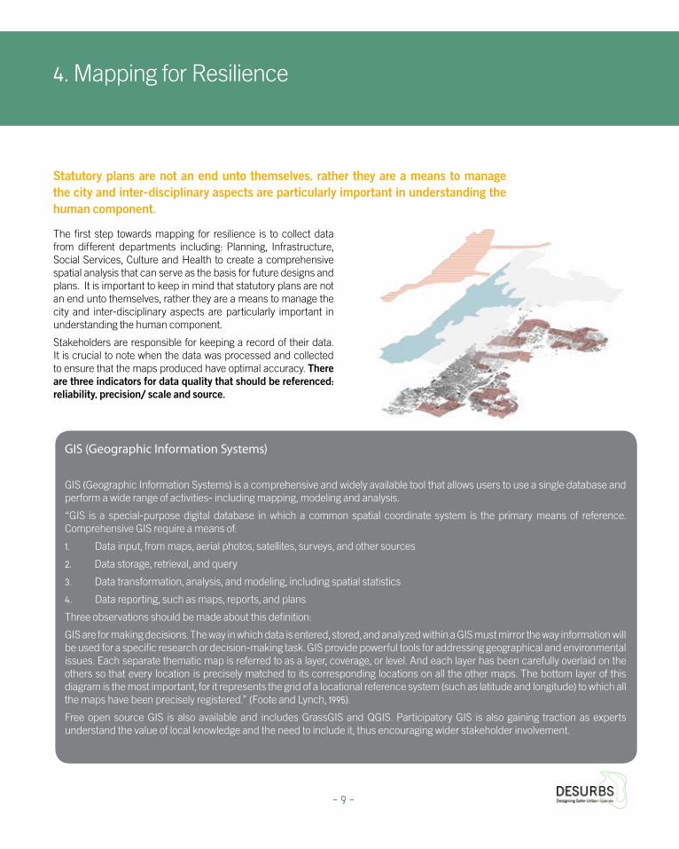
The first step towards mapping for resilience is to collect data from different departments including: Planning, Infrastructure, Social Services, Culture and Health to create a comprehensive spatial analysis that can serve as the basis for future designs and plans. It is important to keep in mind that statutory plans are not an end unto themselves, rather they are a means to manage the city and inter-disciplinary aspects are particularly important in understanding the human component.
Stakeholders are responsible for keeping a record of their data. It is crucial to note when the data was processed and collected to ensure that the maps produced have optimal accuracy. There are three indicators for data quality that should be referenced: reliability, precision/ scale and source.
Statutory plans are not an end unto themselves, rather they are a means to manage the city and inter-disciplinary aspects are particularly important in understanding the human component.
GIS (Geographic Information Systems)
GIS (Geographic Information Systems) is a comprehensive and widely available tool that allows users to use a single database and perform a wide range of activities- including mapping, modeling and analysis.
“GIS is a special-purpose digital database in which a common spatial coordinate system is the primary means of reference. Comprehensive GIS require a means of:
1. Data input, from maps, aerial photos, satellites, surveys, and other sources
2. Data storage, retrieval, and query
3. Data transformation, analysis, and modeling, including spatial statistics
4. Data reporting, such as maps, reports, and plans
Three observations should be made about this definition:
GIS are for making decisions. The way in which data is entered, stored, and analyzed within a GIS must mirror the way information will be used for a specific research or decision-making task. GIS provide powerful tools for addressing geographical and environmental issues. Each separate thematic map is referred to as a layer, coverage, or level. And each layer has been carefully overlaid on the others so that every location is precisely matched to its corresponding locations on all the other maps. The bottom layer of this diagram is the most important, for it represents the grid of a locational reference system (such as latitude and longitude) to which all the maps have been precisely registered.” (Foote and Lynch, 1995).
Free open source GIS is also available and includes GrassGIS and QGIS. Participatory GIS is also gaining traction as experts understand the value of local knowledge and the need to include it, thus encouraging wider stakeholder involvement.
- 9 -

The DESURBS security products were designed to address a wide range of security incidents and natural disasters that threaten urban populations and environments. A leading conceptual principle in the design is its seamless integration into urban space. Many security interventions and products hinder flow and movement, disturbing urban rhythms in addition being a visible blight. The DesUrbs components are sensitive to the importance of open and public spaces. They are designed to operate in a manner that is flexible, thus contributing to the establishment of a more robust and resilient urban space while remaining sensitive to a security culture with liberal values.
CityZen CityTalk HopeSpot
4.1 DESURBS Security Products
Receiving the �ltered answers in a clear and user-friendly way
CityTalk by Hanna Spaander 2014
Receiving the �ltered answers in a clear and user-friendly way
CityTalk by Hanna Spaander 2014
- 10 -

Collecting Types of GIS Data with DesUrbs Security Products
The DESURBS security products, CityZen and HopeSpot (p. 12-13) developed for the project also enable the collection and use of data that contributes to resilience. Within these definitions, we can also add information collected from residents and not solely from official stakeholders. The DESURBS CityZen application, an image and GPS reporting Smartphone application for two way communication between citizens and the authorities, can collect x, y coordinates from live reports made by residents or visitors who provide real time information regarding problems areas in the city. These reports can be compiled into a comprehensive database that can be used to spot recurring events and identify vulnerability trends. The HopeSpot balloon can be placed at pre-identified locations that qualify as “population assistance points” as a mitigation step (for more details see Section 5.5 – Prioritising Risk Reduction)
For linear data, a street name or code can be used in the tabular data, i.e. routes closed for parades need to have the exact street code used in the municipal GIS system.
For point data such as police barriers or water distribution points it is advised to use x, y coordinates or a street address (street number and entrance). For polygon data one can use the building ID or x, y of centroid. In this manner it is easier to fill out a table with local data and information and afterwards to include the data in GIS map making.
Analysis of CityZen Pilot at the 2014 Jerusalem Marathon- 269 reports
- 11 -
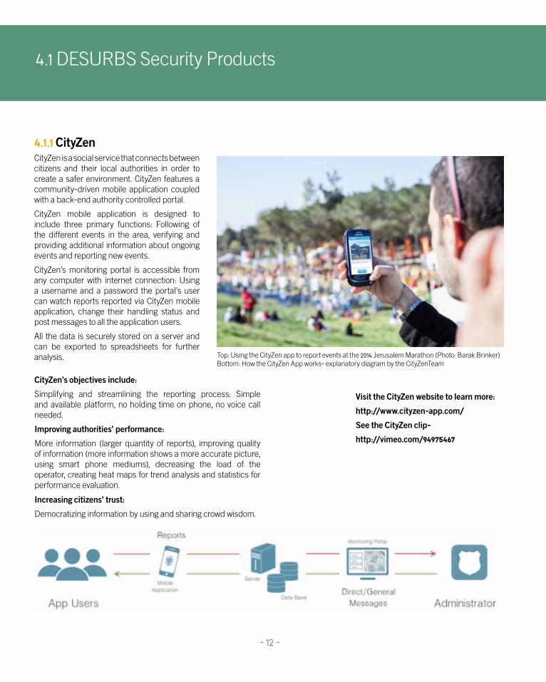
4.1.1 CityZenCityZen is a social service that connects between citizens and their local authorities in order to create a safer environment. CityZen features a community-driven mobile application coupled with a back-end authority controlled portal.
CityZen mobile application is designed to include three primary functions: Following of the different events in the area, verifying and providing additional information about ongoing events and reporting new events.
CityZen’s monitoring portal is accessible from any computer with internet connection: Using a username and a password the portal’s user can watch reports reported via CityZen mobile application, change their handling status and post messages to all the application users.
All the data is securely stored on a server and can be exported to spreadsheets for further analysis.
Visit the CityZen website to learn more:
http://www.cityzen-app.com/
See the CityZen clip-
http://vimeo.com/94975467
Increasing citizens’ trust:
Democratizing information by using and sharing crowd wisdom.
CityZen’s objectives include:
Simplifying and streamlining the reporting process: Simple and available platform, no holding time on phone, no voice call needed.
Improving authorities’ performance:
More information (larger quantity of reports), improving quality of information (more information shows a more accurate picture, using smart phone mediums), decreasing the load of the operator, creating heat maps for trend analysis and statistics for performance evaluation.
Top: Using the CityZen app to report events at the 2014 Jerusalem Marathon (Photo: Barak Brinker)Bottom: How the CityZen App works- explanatory diagram by the CityZenTeam
4.1 DESURBS Security Products
- 12 -

4.1.2 HopeSpotThe HopeSpot’s objective is to provide an efficient, cost-effective, accessible and portable product to ease communication challenges with crowds. It was designed as a flexible component of the supporting auxiliary infrastructure with uses during emergency and planned scenarios. A planned event, such as marathons and concerts, necessitates communication with a large amount of participants on how to best navigate urban space in a clear and safe manner.
The HopeSpot can be virtually visualized in an urban context using powerful visualization software, such as TerraExplorer (see p. 36), to place the balloon at a point that provides optimal visibility and deciding the best location for this product.
Watch the HopeSpot clip-
http://vimeo.com/94975469
Top: HopeSpot in an urban environment, artist rendering, HopeSpot TeamBottom: How the HopeSpot works- explanatory diagram, HopeSpot Team
The HopeSpot balloon, developed as a working prototype, focuses on the creation of a mark in the sky pointing survivors of large scale disasters to the place where they can get help, or be used in the same manner in a planned event by pointing people toward first aid locations. The balloon is inflated with helium and set aloft to a height of up to 50 metres (the height is set according to aviation regulation in Israel, yet the balloon is capable of reaching a height of 300 metres and more). It has a distinct hue that is visible in daytime, the last prototype test reached daytime effective visibility of up to 300 metres; while at nighttime an LED light cable points toward the ground with effective visibility of up to five kilometers.
- 13 -
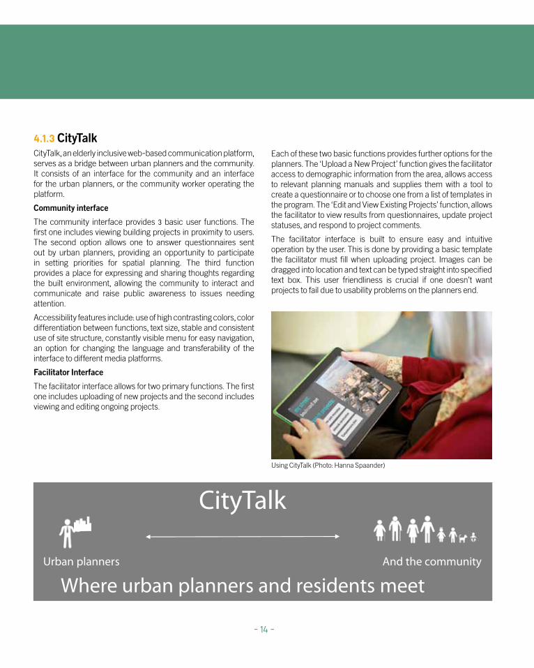
4.1.3 CityTalk CityTalk, an elderly inclusive web-based communication platform, serves as a bridge between urban planners and the community. It consists of an interface for the community and an interface for the urban planners, or the community worker operating the platform.
Community interface
The community interface provides 3 basic user functions. The first one includes viewing building projects in proximity to users. The second option allows one to answer questionnaires sent out by urban planners, providing an opportunity to participate in setting priorities for spatial planning. The third function provides a place for expressing and sharing thoughts regarding the built environment, allowing the community to interact and communicate and raise public awareness to issues needing attention.
Accessibility features include: use of high contrasting colors, color differentiation between functions, text size, stable and consistent use of site structure, constantly visible menu for easy navigation, an option for changing the language and transferability of the interface to different media platforms.
Facilitator Interface
The facilitator interface allows for two primary functions. The first one includes uploading of new projects and the second includes viewing and editing ongoing projects.
Each of these two basic functions provides further options for the planners. The ‘Upload a New Project’ function gives the facilitator access to demographic information from the area, allows access to relevant planning manuals and supplies them with a tool to create a questionnaire or to choose one from a list of templates in the program. The ‘Edit and View Existing Projects’ function, allows the facilitator to view results from questionnaires, update project statuses, and respond to project comments.
The facilitator interface is built to ensure easy and intuitive operation by the user. This is done by providing a basic template the facilitator must fill when uploading project. Images can be dragged into location and text can be typed straight into specified text box. This user friendliness is crucial if one doesn’t want projects to fail due to usability problems on the planners end.
Using CityTalk (Photo: Hanna Spaander)
Where urban planners and residents meet
CityTalk
Urban planners And the community
- 14 -
4.2 Recommended Layers for Urban Resilient Design
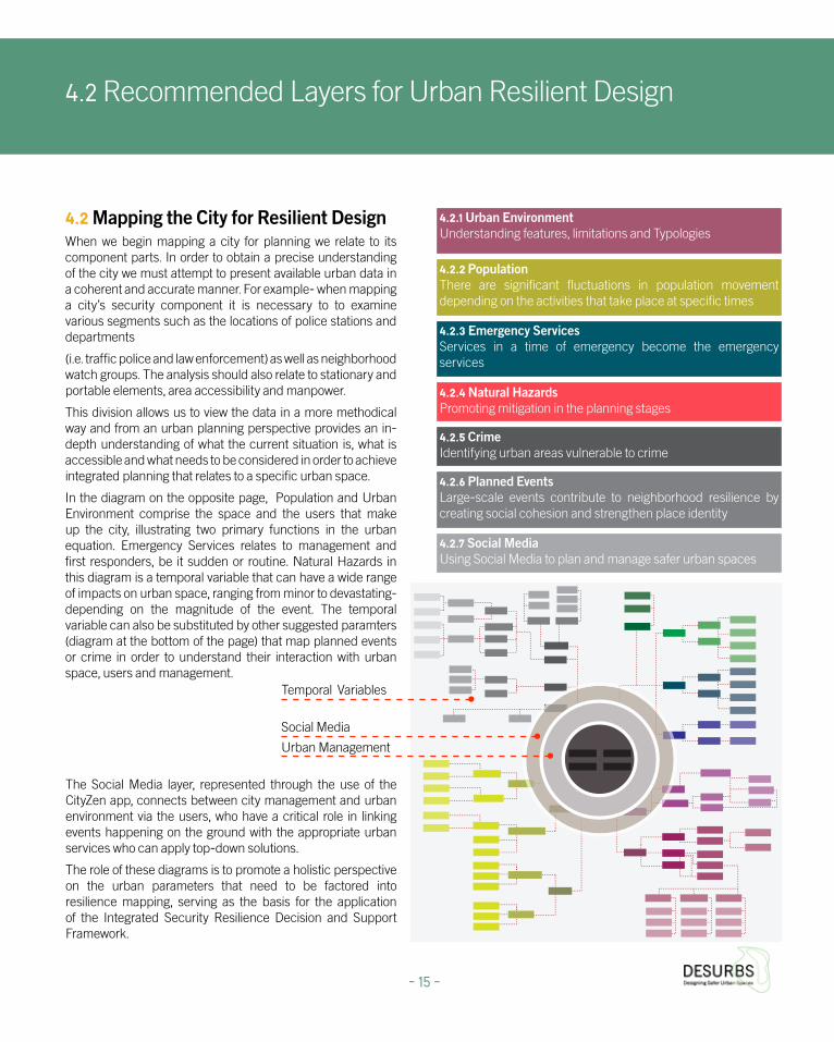
4.2 Mapping the City for Resilient DesignWhen we begin mapping a city for planning we relate to its component parts. In order to obtain a precise understanding of the city we must attempt to present available urban data in a coherent and accurate manner. For example- when mapping a city’s security component it is necessary to to examine various segments such as the locations of police stations and departments
(i.e. traffic police and law enforcement) as well as neighborhood watch groups. The analysis should also relate to stationary and portable elements, area accessibility and manpower.
This division allows us to view the data in a more methodical way and from an urban planning perspective provides an in-depth understanding of what the current situation is, what is accessible and what needs to be considered in order to achieve integrated planning that relates to a specific urban space.
In the diagram on the opposite page, Population and Urban Environment comprise the space and the users that make up the city, illustrating two primary functions in the urban equation. Emergency Services relates to management and first responders, be it sudden or routine. Natural Hazards in this diagram is a temporal variable that can have a wide range of impacts on urban space, ranging from minor to devastating- depending on the magnitude of the event. The temporal variable can also be substituted by other suggested paramters (diagram at the bottom of the page) that map planned events or crime in order to understand their interaction with urban space, users and management.
The Social Media layer, represented through the use of the CityZen app, connects between city management and urban environment via the users, who have a critical role in linking events happening on the ground with the appropriate urban services who can apply top-down solutions.
The role of these diagrams is to promote a holistic perspective on the urban parameters that need to be factored into resilience mapping, serving as the basis for the application of the Integrated Security Resilience Decision and Support Framework.
- 15 -
Urban Management
Social Media
Temporal Variables
4.2.4 Natural Hazards Promoting mitigation in the planning stages
4.2.2 Population There are significant fluctuations in population movement depending on the activities that take place at specific times
4.2.3 Emergency Services Services in a time of emergency become the emergency services
4.2.1 Urban Environment Understanding features, limitations and Typologies
4.2.6 Planned Events Large-scale events contribute to neighborhood resilience by creating social cohesion and strengthen place identity
4.2.7 Social Media Using Social Media to plan and manage safer urban spaces
4.2.5 Crime Identifying urban areas vulnerable to crime

4.2 Recommended Layers for Urban Resilient Design
Parameters for Consideration in Resilient Mapping
- 16 -
Age Range
Socioeconomic Status
Household Type
Employment Areas
Residential Areas
Day
Night
Place
Special Communities
Statistical Data
District Administrators
Density
Recreation
Elderly
Disabled Pop.
Children
Exterior
Interior
Events
Development
Demographics
Earthquakes
Ground Type
Water Sources
Conduit
Brook
Stream
River
Reservoirs
Springs
Surface Water Sources
Subterranean Water Sources
Sea
Climate
Temperatures
Tsunami/Storms
Floods
Differential
Average
Topography
Vulnerable Areas
Secure Areas
Traffic Arteries Snow
Red Cross
Hospitals
Clinics
Emergecy Medical Center
Civil/Community Policing
Municipal
Police Stations
Fire Stations
Community Volunteers
Portable
Stationary
Portable
Stationary
Portable
Stationary
Medical
Security
FireFighters
Emergency Services
Night
DayParcellation
Uses
Public Spaces
Heritage Areas
Density
Land-Use
Existing
Planned
Built
Natural Hazards
Urban EnvironmentPopulation
Topography
LowlandsHighlands
Home Front Command
Aid Centers
Public Shelters
Movement
Vehicular
Pedestrians
Bicycles/Prams
Formal
Informal
Evacuation Routes
Neighborhoood
City Scale
Geology
Seismic Maps
Heritage Areas
Old Buildings
Day/Night
Seasons
Home Front Command
Day
Night
Parks
Landmarks
Public
Semi-Public
OutsideGathering PlacesMovement
Vehicular
Pedestrians
Bicycles/Prams
Private Open Space
Public Open Space
Construction materials:
It is important to pay special attention to the structural materials, particularly in areas sensitive to hazards and consider the ramifications of weaker materials. An example of this is the extensive use of glass, often the weakest part of structure. Glass is a material that has been identified as a major cause of injuries in the event of disasters (Chipley, 2003). The DESURBS Decision Support System Portal features a Strength of Materials Database that reviews a wide range of materials (Strema DB) http://desurbs.it-innovation.soton.ac.uk/strema/
4.2.1 Urban EnvironmentUnderstanding features, limitations and typologies
Mixed uses and zoning design features:
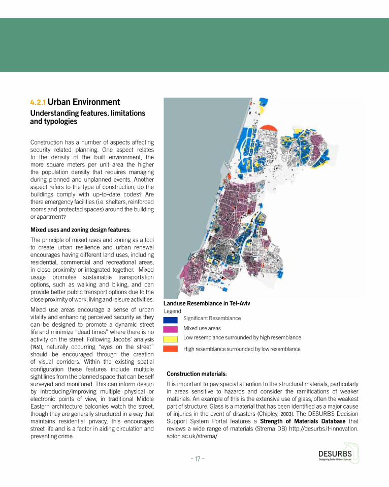
The principle of mixed uses and zoning as a tool to create urban resilience and urban renewal encourages having different land uses, including residential, commercial and recreational areas, in close proximity or integrated together. Mixed usage promotes sustainable transportation options, such as walking and biking, and can provide better public transport options due to the close proximity of work, living and leisure activities.
Mixed use areas encourage a sense of urban vitality and enhancing perceived security as they can be designed to promote a dynamic street life and minimize “dead times” where there is no activity on the street. Following Jacobs’ analysis (1961), naturally occurring “eyes on the street” should be encouraged through the creation of visual corridors. Within the existing spatial configuration these features include multiple sight lines from the planned space that can be self surveyed and monitored. This can inform design by introducing/improving multiple physical or electronic points of view, in traditional Middle Eastern architecture balconies watch the street, though they are generally structured in a way that maintains residential privacy, this encourages street life and is a factor in aiding circulation and preventing crime.
Landuse Resemblance in Tel-Aviv
Significant Resemblance
Mixed use areas
Construction has a number of aspects affecting security related planning. One aspect relates to the density of the built environment, the more square meters per unit area the higher the population density that requires managing during planned and unplanned events. Another aspect refers to the type of construction; do the buildings comply with up-to-date codes? Are there emergency facilities (i.e. shelters, reinforced rooms and protected spaces) around the building or apartment?
Low resemblance surrounded by high resemblance
High resemblance surrounded by low resemblance
Legend
- 17 -

Heritage as a Contributor to Urban Resilience
The open secret for urban resilience is in the mixed uses of the city, its cultural diversity and sensitivities to environmental assessment. While the latest UNESCO recommendation on the Historic Urban Landscape underscores the need for an integrative approach to planning, these ‘mainstream’ actions need to be expanded, as most urban development affected by climate change and other disasters are usually in areas that are environmentally unsustainable on ‘left-over urban spaces’ that were cheap and readily available.
“Heritage if well maintained can positively contribute to reducing disaster risks. This is true not only for natural heritage resources that guarantee the proper functioning of ecosystems and the beneficial effect of their goods and services, but also for cultural heritage properties that- as a result of traditional knowledge accumulated over centuries have proven to be resilient to disasters while providing shelter and psychological support to affected communities” (UNESCO, ‘Managing Disaster Risks for World Heritage’, 2010, 3–4)
Heritage sites provide a significant element of social cohesion and sustainable development and their erosion has extremely negative ramifications for society and its resilience. Human behaviour and decisions developed in normal times can greatly increase the resilience of these sites, thus reducing the impact of potential disasters. Specific disasters are generally far more destructive than prolonged processes of deterioration. A short-lived disaster can swiftly and suddenly devastate an entire area, and therefore managing disaster risks is an urgent issue. Where traditional knowledge systems exist it is vital to integrate them into the Disaster Risk Management. These wisdoms and memories of the city can provide information and awareness, enabling heritage to contribute to the development of resilience parameters.
(Turner and Singer, 2014)
An entrance to Sultan Ahmed Mosque, Istanbul (Photo: Rachel Singer)
4.2 Recommended Layers for Urban Resilient Design
- 18 -
Relevant layers:
Built areas – polygon and points
Required fields: ground level, roof height, address, shelters (apartment or building), year of construction, construction that is not according to the standard, year of building code.
Optional fields:
Size of covered parking lots (which can be used as covered emergency centers). Residents with disabilities by residence - points This optional layer is sourced from the welfare authorities. This layer has x, y data and individuals with disabilities known to welfare authorities who require assistance during emergency situations are included. Layer fields: Name, Type, Disability (if there is a welfare authorities system coding, the degree of risk or need).
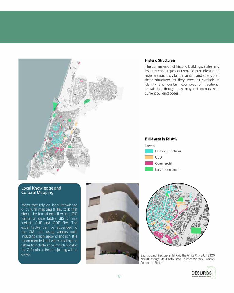
Historic Structures:
The conservation of historic buildings, styles and textures encourages tourism and promotes urban regeneration. It is vital to maintain and strengthen these structures as they serve as symbols of identity and contain examples of traditional knowledge, though they may not comply with current building codes.
Build Area in Tel Aviv
Legend
Historic Structures
CBD
Commercial
Large open areas
Bauhaus architecture in Tel Aviv, the White City, a UNESCO World Heritage Site (Photo: Israel Tourism Ministry) Creative Commons, Flickr
Local Knowledge and Cultural Mapping
Maps that rely on local knowledge or cultural mapping (Pillai, 2013) that should be formatted either in a GIS format or excel tables. GIS formats include .SHP and .GDB files. The excel tables can be appended to the GIS data using various tools including union, append and join. It is recommended that while creating the tables to include a column identical to the GIS data so that the joining will be easier.
- 19 -

4.2 Recommended Layers for Urban Resilient Design
Parks
OutsideGathering PlacesMovement
Night
DayParcellation
Uses
Public Spaces
Heritage Areas
Density
Land-Use
Existing
Planned
Built
Urban Environment
Movement
Vehicular
Pedestrians
Bicycles/Prams
Formal
Informal
Evacuation Routes
Neighborhoood
City Scale
Public
Semi-Public
Landmarks
Bicycles/Prams
Pedestrians
Vehicular
Public Open Space
Private Open Space
Relevant layers:
Required fields: building age, height and building material; street length, width, type and sidewalk; land-use, points of interest, infrastructure.
This data should be considered within the vulnerable perimeters and brought to the attention of the appropriate stakeholders.
- 20 -
Urban Environment Parameters

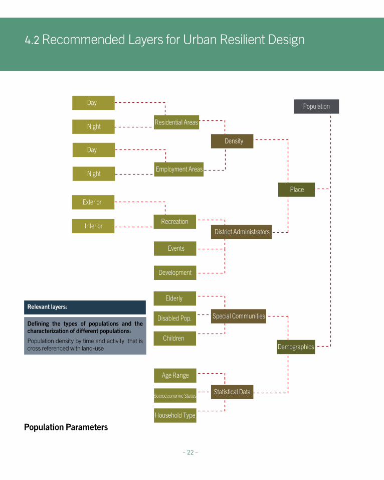
4.2.2 PopulationThere are significant fluctuations in population movement depending on activities that take place at specific times
Population density in Tel-Aviv
Legend
Population by statistical area
It is important to include comprehensive population data in an analysis, and try to present the shifts over time. Since the information available to all authorities usually represents population through statistical areas, we rely on this division and show the population stratum through four time scales, which has data on population density during the day, night, weekdays and the weekend. In areas of employment where population density data has not been measured it is possible to estimate population density according to commercial square footage.
Calculating the scope of the population for planned and unplanned events management is part of this process.
Managing populations in a crowded business district during the aftermath of an earthquake will be less complicated if the earthquake hits during the weekend and the business area is empty. The number of casualties will be reduced, and the difficulty in evacuating and treating those injured will be minimal compared to an earthquake that strikes on a busy business day. However, population density is a factor that is often difficult to measure, mainly due to the high changeability during times of the day, week and year. There are significant fluctuations in population movement depending on activities that take place at specific times, such as working, eating, playing and sleeping.
- 21 -
Weekday Weekend
Day WorkingHours
Night
CBD
Residential
Mixed Use
Industrial
4.2 Recommended Layers for Urban Resilient Design
Age Range
Socioeconomic Status
Household Type
Employment Areas
Residential Areas
Day
Night
Place
Special Communities
Statistical Data
District Administrators
Density
Recreation
Elderly
Disabled Pop.
Children
Exterior
Interior
Events
Development
Demographics
Population
Day
Night
Relevant layers:
Defining the types of populations and the characterization of different populations:
Population density by time and activity that is cross referenced with land-use
- 22 -
Population Parameters

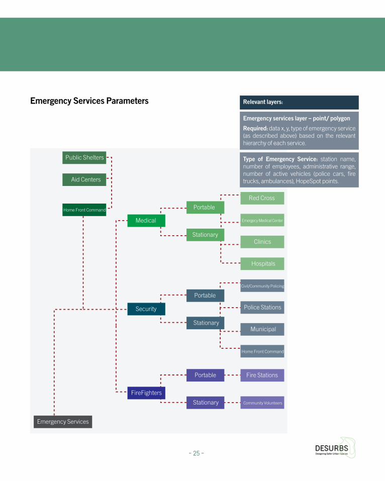
4.2.3 Emergency ServicesServices in a time of emergency become the emergency services
The placement of emergency services, where the primary goal is to increase service provider access in times of need, for both planned and unplanned events, should be made following an integrated spatial analysis.
2. http://ready.org.il/israel/israeli-authorities/
3. see FEMA, the local government is responsible while the federal resources are at their disposal (p. 24)
http://www.fema.gov/media-library-data/20130726-1828-25045-0014/cpg_101_comprehensive_preparedness_guide_developing _and_maintaining _emergency_operations_plans_2010.pdf
Access to emergency services
Whereas a simple radius is often used for distance measurement, a more detailed isochrones calculation should be used to calculate the range of impact for emergency service providers. This calculation determines how long it takes the service provider to reach any point in the city, rather than checking uniform distances. For example, it is preferable to determine the places that are farther than twenty minutes from the police station using varying modes of transport rather than examining the areas in the city that extend beyond a 350 metre radius. If the NetWork Analysis extension in GIS is unavailable, then the distance calculator can be used to create buffer zones (Buffer Tool) around police stations as a secondary alternative.
It should be noted that in the state of emergency the services should come under a single jurisdiction2 3.
Identification
Emergency services in the city are active 24 hours a day, 365 days a year. The higher the availability and ability of the emergency services to serve the urban population, the more the city is perceived to be safe and more resilient, by residents and visitors alike. Services are often dispersed and different countries and cities have different structures and interrelationships between local and national authorities. As a first step these services need to be mapped to provide a baseline for communication on urban design issues.
Emergency services are divided into four primary groups.
I. Police (both State and Local) - The location of police stations in Israel is mainly a result of historical reasons rather than planning for optimum accessibility. Israeli police forces in cities include not only police stations but also local policing groups - these include: municipal police, private security companies to reinforce the police, civil guard, civilian volunteer organizations (usually at a neighborhood level) and Border Police.
II. Health - Institutions that provide health services include a wide range of state services. These include: state hospitals, health maintenance organizations (HMOs), small specialized hospitals and different forms of private health services; including private hospitals, private clinics, emergency care clinics, private doctors’ clinics as well as first aid stations belonging to different organizations (i.e. the Red Cross).
III. Fire - This group has limited diversity and there is only a single “provider “ of fire protection services. Generally municipal fire stations also serve their surrounding environment beyond the municipal boundaries.
IV. Infrastructure – Providing essential services such as water, sewage, electricity and maintaining strategic open spaces. Critical infrastructure also includes buildings such as hospitals and schools, places where additional care should be taken with safe spaces design as these sites have a supporting role in assisting populations after a large-scale disaster.
Fire Stations coverage
- 23 -

Emergency Services in coverage Tel-Aviv
Legend
Medical Institutions
Police
Ambulance Stations
Firefighter Stations
Ambulance Stations coverage Medical Institutions coverage Police coverage
4.2 Recommended Layers for Urban Resilient Design
- 24 -
Red Cross
Hospitals
Clinics
Emergecy Medical Center
Civil/Community Policing
Municipal
Police Stations
Fire Stations
Community Volunteers
Portable
Stationary
Portable
Stationary
Portable
Stationary
Medical
Security
FireFighters
Emergency Services
Home Front Command
Aid Centers
Public Shelters
Home Front Command
Relevant layers:
Emergency services layer – point/ polygon
Required: data x, y, type of emergency service (as described above) based on the relevant hierarchy of each service.
Type of Emergency Service: station name, number of employees, administrative range, number of active vehicles (police cars, fire trucks, ambulances), HopeSpot points.
- 25 -
Emergency Services Parameters

4.2.4 Natural HazardsPromoting mitigation in the planning stages
There is much diversity in the possible range and scope of natural hazards; some are rare while others pose a credible and constant threat. One of the characteristics of natural hazards is their unpredictability and the difficulty in assessing their magnitude. These factors lead to a tendency to ignore natural hazards during the planning process. Planners by and large do not invest in producing urban environments that are resilient to natural phenomena, and that are only a statistical probability (it isn’t clear when it will happen) or what the scope of the disaster will be However we cannot ignore the fact that natural hazards have been repeatedly documented in most regions, and climate change has brought an increase in extreme weather events. As such it is not wise to completely ignore natural hazards even if philosophically we might not wish to organize our urban space from a defensive perspective against relatively rare events.
In places prone to flooding planning professionals can relate to flood mitigation guides from which permanent or temporary measures can be chosen. Where floods are recurrent permanent measures to relocate buildings should be considered. Otherwise options to prevent water from entering the doors and windows should be a required standard, these include: adding auto-barriers, raised porches and thresholds and using only water resistant external doors and windows. These measures and others have quality standards and offer low cost effective flood protection measures that can also be implemented in retrofitting.
Rapid Urbanization and landslides
Landslides are a growing hazard, particularly in rapidly urbanizing areas where natural vegetation that contributed to ground stabilization is removed to make way for buildings. The 1998 landslides in Sarno, Italy killed 160 residents and caused heavy damage to residential and industrial structures. Landslides are a result of both soil structure and weather conditions. Knowing the risk parameters beforehand and visualizing them on maps can promote preventative measures, such as having an evacuation system, while determining risk levels for different vulnerabilities. This information should also be available to the public to increase awareness of the natural conditions and risks, and enable the public to assess their involvement and actions in these areas.
Top: Freeway 3 in Taiwan after a landslide, 2010 (Photo: REUTERS/National Airborne Service Corps) Creative Commons, FlickrBottom: Hurricane Sandy floods the streets of New York, October 2012 (Photo: Renanit Avitan Fein)
4.2 Recommended Layers for Urban Resilient Design
- 26 -
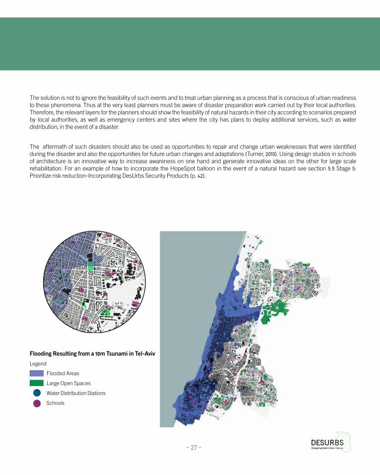
Flooding Resulting from a 10m Tsunami in Tel-Aviv
Legend
Flooded Areas
Large Open Spaces
Water Distribution Stations
Schools
The solution is not to ignore the feasibility of such events and to treat urban planning as a process that is conscious of urban readiness to these phenomena. Thus at the very least planners must be aware of disaster preparation work carried out by their local authorities. Therefore, the relevant layers for the planners should show the feasibility of natural hazards in their city according to scenarios prepared by local authorities, as well as emergency centers and sites where the city has plans to deploy additional services, such as water distribution, in the event of a disaster.
The aftermath of such disasters should also be used as opportunities to repair and change urban weaknesses that were identified during the disaster and also the opportunities for future urban changes and adaptations (Turner, 2010). Using design studios in schools of architecture is an innovative way to increase awareness on one hand and generate innovative ideas on the other for large scale rehabilitation. For an example of how to incorporate the HopeSpot balloon in the event of a natural hazard see section 5.5 Stage 5: Prioritize risk reduction-Incorporating DesUrbs Security Products (p. 42).
- 27 -

Earthquakes
Ground Type
Water Sources
Conduit
Brook
Stream
River
Reservoirs
Springs
Surface Water Sources
Subterranean Water Sources
Sea
Climate
Temperatures
Tsunami/Storms
Floods
Differential
Average
Topography
Vulnerable Areas
Secure Areas
Traffic Arteries Snow
Natural Hazards
Topography
LowlandsHighlands
Geology
Seismic Maps
Heritage Areas
Old Buildings
Day/Night
Seasons
4.2 Recommended Layers for Urban Resilient Design
Relevant layers:
Layer of natural hazards – polygon
Required fields: type of disaster (e.g. blizzard, landslides, flooding, tsunami, earthquake.).
Emergency sites layer - point
Required fields: Type of emergency site (e.g. water distribution site, population assistance point.)
Optional fields: Responsibility for operating point (e.g. Home Front Command, local authority), boundaries, site capacity.
- 28 -
Natural Hazards Parameters

4.2.5 CrimeIdentifying urban areas vulnerable to crime
Crime reporting and their trends are a sensitive issue; in many instances crime statistics are not released to the general public due to privacy policies. However, there are other reasons that prevent crime statistics from being released, including: urban branding, stigmatization, lack of accurate data, sensitivity to police interrogations and other legal issues. Despite this it is possible to view crime data on a smaller scale through statistical areas. This type of data shows urban typologies where crime occurs frequently, such as stairwells and parking lots.
There is an inter-relationship that needs to be accounted for in understanding social resilience and tracking crime. Displaying crime statistics using GIS software enables the identification of vulnerable urban areas and allows the planner to apply solutions, such as those found in CPTED (Crime Prevention Through Environmental Design). Another source of crime data is the municipal hotline. From this source it is possible to obtain X, Y, points, including a breakdown of low level urban crime with an emphasis on vandalism. When architects and planners are aware of recurring cases of vandalism to street furniture, they can understand more about the problematic design situations and refine future design solutions using CPTED methods to design out crime.
Vandalism in Tel Aviv according to cases density
Legend
Least vulnerable
Most vulnerable
The map shows vandalism in Tel Aviv created from reports from the municipal 106 call center, indicating residential areas that have experienced vandalism- an indicator of a lack of social resilience and increased vulnerability. This type of mapping should be part of the urban design decision making process, data from the CityZen app can be cross referenced and super positioned with green spaces for more informed placement of street furniture and lighting.
- 29 -
Relevant layers:
Crime layer- point layer
Required fields: x, y coordinates, number of cases, hour, day, month, year, urban morphology, type of crime (property crimes/assault).
Optional fields: number of victims, profile of victims and perpetrator(s).
If unavailable due to privacy restrictions, this layer can also be presented as a polygon layer that matches the municipal statistical zones or neighborhoods.

Using Local Knowledge Mapping to Plan for Crime Prevention
When planning at a municipal level there are many benefits to having an interdepartmental perspective. For example, the municipal gardening maintenance division can locate vulnerable areas which suffer from wild, overgrown vegetation, clogged drainage or areas that attract unwanted traffic, such as drug usage or littering, because the garden features areas that promote a sense of privacy without visibility. This tacit information can be drawn from stakeholders from the gardening division. This knowledge is usually not digitized, and is available only to stakeholders. After digitizing this information and placing it on cross-departmental maps, the stakeholders from the gardening unit can check if other units or departments flagged their information. In the event that an area is highlighted by others planning at the municipal level should attempt to find an interdepartmental solution that can provide a wider address to the flagged issue rather than treating it as a site specific issue and ignoring the wider context. This overlaying of local knowledge will likely indicate alliances between stakeholders who suffer from shared hazards.
Vandalism in Tel Aviv
Legend
Large open areas
Commercial
CBD
Least vulnerable
Most vulnerableVandalism (Photo: Peter Benedik) Creative Commons, Flickr
Vandalism (Photo: Tim Patterson) Creative Commons, Flickr
4.2 Recommended Layers for Urban Resilient Design
- 30 -

4.2.6 Planned EventsLarge-scale events contribute to neighborhood resilience by creating social cohesion and strengthen place identity
Cities want to hold large-scale events to encourage tourism, trade and strengthen their urban brand image (e.g. through sports, marathons and festivals.). These events are usually held in a small number of venues, as the city does not have unlimited spaces to host large scale events. Showing a layer of spaces that can host venues can aid the municipality in understanding the planning possibilities. Large-scale events held at specified times throughout the year add to neighborhood resilience by creating social cohesion, strengthen place identity and contribute to local culture.
Every city generates activities and happenings for its inhabitants, though large scale events create potential vulnerabilities that need to be addressed. Emergency services preparedness, management during an event and urban design features require various stakeholders to work together and plan the urban perimeter in advance. Planning professionals must check police specifications for conducting large-scale events and arrange the perimeter to comply with these requirements.
Marathon perimeter and Emergency services in Tel-Aviv
Legend
Clinics
Ambulance Station
Hospital
Fire Station
Police
Marathon perimeter
- 31 -
Relevant layers:
Layer of venues that can host planned events – polygon
Required fields: Name of the site, body responsible for maintenance during routine times, regular events, site capacity.
Optional fields: emergency service providers in close proximity (which police station is responsible for the venue - similar fields for MDA, hospitals and fire protection services), sub-district administrative planning / municipal association.
Layer of routes leading into the venue - line / point - an optional layer that can provide information both for planners and event managers. Access routes for emergency services
Required fields: street name, capacity - how many people can pass at a time, a main entrance / secondary axis in and the event of an emergency evacuation.

4.2.7 Social MediaUsing Social Media to plan and manage safer urban spaces
Planners can check the frequency of different urban phenomena with the help of the social media application CityZen. When residents function as ‘eyes on the street’ authorities have an additional asset that helps track events in the city. For example, if a tree has fallen or if the roots interfere with pedestrian traffic on the sidewalk, citizens can use the urban application to report various events and disturbances that are then recorded in a database. These urban phenomena are generally not documented in official channels, and often the planner is not aware of the full implications of these issues. When the planners receive data from the application they can consider the positive or negative aspects that the urban residents report and thus enrich the urban plans.
An important goal of CityZen is to develop a culture of reporting during routine times so that in emergency situations there will be an extensive social and administrative infrastructure in place to obtain data about emergency events in real time.
Another aspect of social media data is the aspect of data control. The control occurs through a community or neighborhood administration, in each community space or neighborhood there are “reporters” belonging to a particular community who monitor that specific neighborhood area. Community Council members oversee the information collected by reporters and it is their responsibility to monitor the quality of the data. Feedback enables people who are avid users of CityZen to know what is happening in their area through the status of reported problems. In times of emergency these users can also be used as representatives of the Community Council due to their familiarity with neighborhood mechanisms, thus making it possible to locate the most reliable and dedicated reporters and get their help during emergencies. Local knowledge is often left undocumented or underutilized though it can be an invaluable resource in times of trouble. When planners receive feedback from end users they can better understand and treat urban phenomena that affect urban resilience.
CityZen reports in Tel-Aviv
Legend
The event was received by the authorities side but has not yet been handledThe event is being handled by the authorities
The event has been handled by the authorities
- 32 -
Relevant layers:
Hazard layers documented by the CityZen mobile application – points layer
Required Fields: name of reporter, hazard type, street name, house number
Optional fields: Rating the severity of the hazard

5. Using the Integrated Security & Resilience Framework to support urban design decisions
5.1 Stage 1 What are the hazards/ threats to the site ?
The aim of this stage is to help begin recognising the threats and hazards to which the chosen project space is exposed. This may sounds like a straightforward requirement but research has found that this critical stage is too often overlooked by key decision makers (see Bosher et al. 2007; Fisher et al. 2012; Chmutina et al., 2014) This is achieved through the description and identification of the hazards and threats provided by the end user.
Supported by the series of statements, we will be able to identify the hazards and threats. If the response to any of the questions is ‘yes’, this hazard/ threat is identified as a potential risk to be dealt with.
These indicative questions can open the eyes of the stakeholders to different variables that influence their workflows and decision making processes. Searching for answers would compel the stakeholders to consult with out of their scope professionals and will eventually promote integration of extensive data sources and holistic urban design. The needed data sources can take form as as GIS layers- as detailed on the next page.
Hazard identification questions
HAZARD INDICATIVE QUESTIONS
Terrorism and Crime “Is the prposed development near an area that might be a potential target of a terrorist at-tack, e.g. government building, military base, transport hub or tourist attraction?”“Is there intelligence or statistics of targeting where the development is located?”
Events with Crowds “Will the proposed development be used to host large-scale public events or gatherings?”“Will there be facilities close to the development, which will potentially generate crowds, e.g. sports stadia, entretainment facilities or transport hubs?”
Earthquakes “Is the development located in an area where earthquakes have occurred in the past, or are predicted in the future?”
Floods and Storms “Is the development site located on a flood plain or close to the sea?”“Have there been any floods or serious storm events within the vicinity of the development in recent years?”
- 33 -

1. Infrastructure - these layers are within the public domain, though as a rule the public has little influence over them. Planning professionals have limited means of influencing infrastructure and many times public initiatives to modify infrastructure plans to better consider environmental and cultural needs fail, as the decision making is limited to the municipal or national level.
Layers needed:
2. Natural hazards (physical related layers) - the physical facet of the urban landscape has much influence on its security. Many natural hazards can be mitigated or have their impact amplified depending on physical features such as: height, soil type, geological fault lines etc. These physical features should be mapped and measured as to whether they are projected to diminish or amplify destruction. Risks should be evaluated based on the proximity and magnitude of the threat. For example, a low-lying urban area may have a low flooding risk based on statistical data, while an urban area that is less shallow or low can be at higher risk since the river floods often and in higher volumes.
3. Crime frequencies in public space - The crime data of an urban area can be obtained from various stakeholders including: Local police forces, national police forces, municipal social services, neighborhood watches, and social media which can assist residents and other city inhabitants to contribute their wisdom and observations. The variability in data sources add other questions, such as whether the data is reliable, updated and uniform.
4. Terror - The urban landscape is susceptible to terror threats due to its high profile, major damage potential and high accessibility. Significant landmarks and large-scale events venues may attract terror threats and urban planners should be aware of the threats. This is another reason for the urban planner to coordinate where possible with national forces and intelligence agencies.
5. Planned Events - Events that take place in the city are an urban branding opportunity as well as a commercial and social happening. Urban preparedness includes drawing a closed perimeter for managing the event and carefully planning evacuation routes. Events usually take place in predefined venues, so planners are encouraged to take into account the capacity of these places. Marathons are an example of an event, which draws participants and spectators along a pre-designed route. The route and the closed perimeter may vary over the years but since the urban area is limited there are frequently accessed streets and any retrofitting or urban planning in them or near them should take into account their function as a segment of a marathon route.
Collecting information
Collecting Sorting Classification
Graphic and quantitative data display - GIS
Superposition of information - combining layers in order to get an in-depth view
Integrated Security and Resilience Design Framework
Conclusions
5. Using the Integrated Security & Resilience Framework to support urban design decisions
- 34 -

5.2 Stage 2: Identifying and Assessing the vulnerability of urban spaces to specific hazards/ threats Vulnerability assessment is the process of assessing the susceptibility of the intrinsic properties (the structure, materials, construction and planning) to a hazard/threat that can lead to an event with a consequence
Vulnerable urban perimeters must be considered within a scaled context. Whether the urban planning process is taking place on a block, street or building, the planner should also review the wider context. For instance, buildings located near a more vulnerable space, such as a prime landmark or vital infrastructure should consider scenarios such as terrorist attacks or an industrial accident. Streets that are retrofitted in earthquake prone areas
should at the same time make sure to identify evacuation routes and make provisions for the safe passage of emergency vehicles.
The vulnerable perimeters may indicate:
o Vulnerability for specific stakeholders
o Vulnerability of urban features that can be addressed by existing manuals (see appendix 8.2 for review)
o Vulnerable perimeters that currently cannot be retrofitted by urban design, but can use industrial design products to mitigate vulnerabilities.
The Jerusalem Festival of Lights, an annual planned event that brings hundreds of thousands of visitors to the Old City at night (Photo: Noam Chen) Creative Commons, Flickr
- 35 -

Vulnerabilities’ categories and rating scale
Vulnerability/ Score 1 2
Planning Full implementation of planning policy and pro-cedures, with due consideration for potential risks at a land-use, individual site or strategic planning level.
Substantial implementation of planning policy and procedures, with due consideration for potential risks at a land-use, individual site or strategic plan-ning level.
Design Comprehensive built environment design with full consideration of the processes taking place within the resultant spaces, including how the built ele-ments could potentially impede the effectiveness of safety and security functions.
Substantial consideration within the built environ-ment design of the processes taking place within the resultant spaces or how the built elements could potentially impede the effectiveness of safety and security functions.
Management Comprehensive site management and monitoring programme, particularly around safety procedures and considerations of the developments ongoing processes and functions.
Reasonable site management and monitoring programme, including safety procedures and con-siderations of the developments ongoing processes and functions.
StructuralComprehensive structural design which considers integrity to a range of factors; proposed solution promotes robustness over considerations, such as cost.
Substantial consideration of structural designs integrity or robustness to a range of factors.
MaterialComprehensive consideration of materials perfor-mance and appropriateness for given design, with solution promoting maximum function over other considerations, such as cost.
Substantial consideration of materials perfor-mance and appropriateness for given design.
MaintenanceComprehensive maintenance of built environment assets and processes, with proactive programme to replace and repair equipment vital to site function.
Substantial maintenance of built environment as-sets and processes, with programme of monitoring for defects to repair.
MitigationComprehensive hazard mitigation or risk assess-ment procedures, integrated into all levels of gover-nance, design, construction and management.
Substantial hazard mitigation or risk assessment procedures.
Emergency responseComprehensive emergency response design, co-produced by local emergency services providers.
Substantial consideration of emergency response in built environment design, including consulta-tion and feedback from local emergency services providers.
StakeholdersFull engagement with all significant stakeholders, at the optimum stage in the design process.
Substantial engagement with all significant stake-holders, at different stages throughout the design process.
5. Using the Integrated Security & Resilience Framework to support urban design decisions
- 36 -

3 4 5
Some implementation of planning policy and procedures, with due consideration for potential risks at a land-use, individual site or strategic planning level.
Little consideration of planning policies and procedures, or potential risks.
No consideration of planning policies and procedures, or potential risks.
Some consideration within the built environment design of the processes taking place within the resultant spaces or how the built elements could potentially impede the effectiveness of safety and security functions.
Little consideration within the built environ-ment design of the processes taking place within the resultant spaces or how the built elements could potentially impede the ef-fectiveness of safety and security functions.
No consideration within the built environ-ment design of the processes taking place within the resultant spaces or how the built elements could potentially impede the ef-fectiveness of safety and security functions.
Basic site management and monitoring programme, with some consideration of the areas of safety procedures and the develop-ments ongoing processes and functions.
Little site management and monitoring pro-gramme, particularly in the areas of safety procedures and the developments ongoing processes and functions.
No programme of site management and monitoring.
Some consideration of structural designs integrity or robustness to a range of factors.
Little consideration of materials perfor-mance and appropriateness for given design.
No consideration of structural designs integ-rity or robustness.
Some consideration of materials per-formance and appropriateness for given design.
Little consideration of materials perfor-mance and appropriateness for given design.
No consideration of materials performance and appropriateness for given design.
Basic maintenance of built environment assets and processes, with reactive repair of defects.
Little maintenance of built environment as-sets and processes, or defects repair.
No maintenance of built environment assets and processes.
Basic hazard mitigation or risk assessment procedures.
Little in the way of hazard mitigation or risk assessment procedures.
No hazard mitigation or risk assessment procedures.
Some consideration of emergency response in built environment design, with limited input by local emergency services provid-ers.
Little consideration of emergency response in built environment design, or input by local emergency services providers.
No consideration of emergency response.
Some engagement with critical stakehold-ers at some point in the design process.
Little engagement with critical stakeholders. No engagement with critical stakeholders.
- 37 -

5. Using the Integrated Security & Resilience Framework to support urban design decisions
- 38 -
Layers needed:
Visualization tools
Powerful visualization aids can convey an idea better than texts or tables. An example for a powerful visual aid is the Secure By Design Interactive Guide, which shows crime opportunities created by poor design and offers solutions. In this interactive guide, planners and other stakeholders can identify urban situations that resemble the urban environment they are dealing with. The guide helps in spotlighting problematic urban features and suggests planning related solutions such as locations for entrances, windows and hedges.
Another example of a powerful visual aid is a GIS based software called TerraExplorer. This software allows urban planners to add diagonal photographs of the city thus visualizing a real-time picture of its landscape. This software also enables an automatic conversion of 2D photographs so that time spent on visualization processes are significantly reduced.
After adding GIS layers to the photographs, the urban designer can use the built-in GIS features to measure, analyze, edit and query the data. These features can also be uploaded to mobile devices, which allows different urban stakeholders to walk around with the model in hand, testing variables, comparing solutions and options and update the data constantly. This software also has an open access version that holds less features but none the less enables users to expand their GIS experience with a variety of visualization options.
Visual demonstrations are a preferable way to highlight a problem and demonstrate solutions and different options to address the problem. They allow merging of different types of data into one access point and use the same tools and methodology on different types of data. With powerful visual aids the stakeholders involved in the different aspects of the urban perimeter can measure and analyze the issues at hand before undertaking an extensive construction project and by using mobile apps they can also make sure the data is constantly being updated.
1. Special needs populations– including seniors, children, and individuals with disabilities. Using population surveys it is possible to make forecasts and identify what services will be needed in the future. Cities are dynamic in their renewal and reuse of buildings according to the current needs of the populations.
2. Services for specific populations as an indicator of existing populations (i.e. a large amount of kindergartens indicates many young families).
3. Playgrounds and parks - Continuous regeneration of these sites is another indication of populations with young children.
4. Population density - Polygon (based on Statistical Areas layer) and four time scales.
Required: Number of statistical area, density during the day, density at night, weekday density, weekend density.
The NYC Highline- a 2.3 km. linear park built on a disused elevated railroad that was repurposed for a public park (Photo: Esther Westerveld) Creative Commons, Flickr
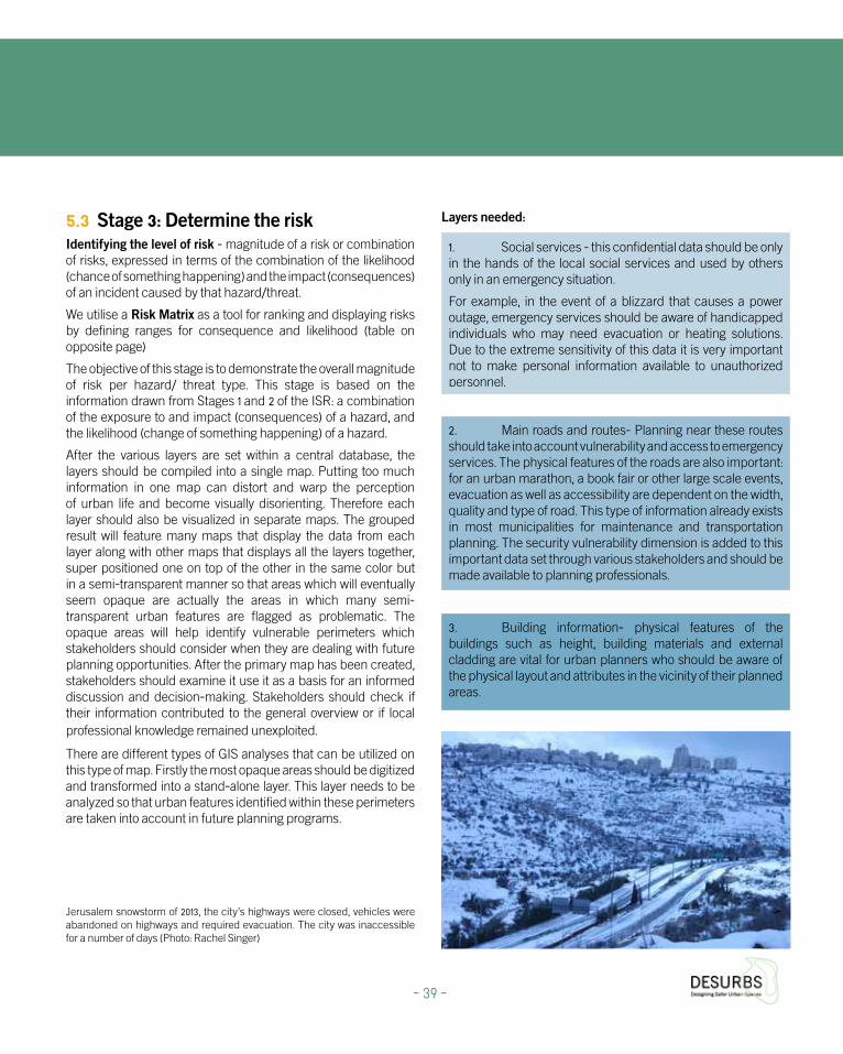
5.3 Stage 3: Determine the riskIdentifying the level of risk - magnitude of a risk or combination of risks, expressed in terms of the combination of the likelihood (chance of something happening) and the impact (consequences) of an incident caused by that hazard/threat.
We utilise a Risk Matrix as a tool for ranking and displaying risks by defining ranges for consequence and likelihood (table on opposite page)
The objective of this stage is to demonstrate the overall magnitude of risk per hazard/ threat type. This stage is based on the information drawn from Stages 1 and 2 of the ISR: a combination of the exposure to and impact (consequences) of a hazard, and the likelihood (change of something happening) of a hazard.
After the various layers are set within a central database, the layers should be compiled into a single map. Putting too much information in one map can distort and warp the perception of urban life and become visually disorienting. Therefore each layer should also be visualized in separate maps. The grouped result will feature many maps that display the data from each layer along with other maps that displays all the layers together, super positioned one on top of the other in the same color but in a semi-transparent manner so that areas which will eventually seem opaque are actually the areas in which many semi-transparent urban features are flagged as problematic. The opaque areas will help identify vulnerable perimeters which stakeholders should consider when they are dealing with future planning opportunities. After the primary map has been created, stakeholders should examine it use it as a basis for an informed discussion and decision-making. Stakeholders should check if their information contributed to the general overview or if local professional knowledge remained unexploited.
There are different types of GIS analyses that can be utilized on this type of map. Firstly the most opaque areas should be digitized and transformed into a stand-alone layer. This layer needs to be analyzed so that urban features identified within these perimeters are taken into account in future planning programs.
1. Social services - this confidential data should be only in the hands of the local social services and used by others only in an emergency situation.
For example, in the event of a blizzard that causes a power outage, emergency services should be aware of handicapped individuals who may need evacuation or heating solutions. Due to the extreme sensitivity of this data it is very important not to make personal information available to unauthorized personnel.
2. Main roads and routes- Planning near these routes should take into account vulnerability and access to emergency services. The physical features of the roads are also important: for an urban marathon, a book fair or other large scale events, evacuation as well as accessibility are dependent on the width, quality and type of road. This type of information already exists in most municipalities for maintenance and transportation planning. The security vulnerability dimension is added to this important data set through various stakeholders and should be made available to planning professionals.
3. Building information- physical features of the buildings such as height, building materials and external cladding are vital for urban planners who should be aware of the physical layout and attributes in the vicinity of their planned areas.
Layers needed:
Jerusalem snowstorm of 2013, the city’s highways were closed, vehicles were abandoned on highways and required evacuation. The city was inaccessible for a number of days (Photo: Rachel Singer)
- 39 -

4. Population density- Population densities in cities vary across hours, days and events during the year. Areas crowded during the weekends can be desolate during weekdays and venues hosting large-scale national events may not attract crowds during the rest of the year. Mapping population density is very difficult and there are currently different methods available for this task: monitoring cell phones is an example of a method that is used by the police forces. The primary problem is that existing tools face challenges in predicting crowds and their trends. As a result data remains vague and imprecise, and should be considered as a prediction rather than an absolute number. Furthermore, consider when crowds are considered a weakness, and when it can strengthen a city. During an earthquake or a terror attack it can be a major hazard, though in day-to-day routine the presence of people on the street can enhance the sense of security.
5. Urban Management - Regular maintenance of the urban landscape is often overlooked and suffers from low budget allocations or is outsourced with little municipal oversight. These issues create vulnerable areas that municipal stakeholders are not aware of in the pre-planning stages and are only evident after the building is complete. When a certain urban perimeter is being re-planned, the stakeholders should point out the maintenance procedures and their expected input, both economic and human, thus helping decision makers choose an appropriate option that can be reasonably maintained.
Maintenance, as a contributor to vulnerability, should be carefully examined by stakeholders involved in planning and design procedures so that the urban elements will be well maintained.
Overall vulnerability of the space
Sit
e Vu
lner
abili
ty
V.High
High
Medium
Low
V.Low
V.Low Low Medium High V.High
Design Vulnerability
Identifying levels of risk and dismantling it to its components allows us to prioritize the urban risks and approach the solutions and mitigation with an educated and thought through approach. Also, this deconstruction of risk factors allows us to re-assess the vulnerability and re-adjust the priorities according to future developments and inputs.
Overall vulnerability of the space, the overall vulnerability will be determined as a combination of a highest design vulnerability score and the highest site vulnerability score.
5. Using the Integrated Security & Resilience Framework to support urban design decisions
- 40 -
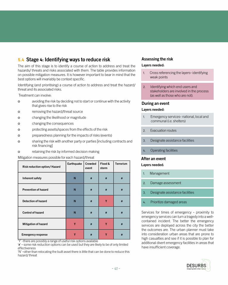
5.4 Stage 4: Identifying ways to reduce riskThe aim of this stage is to identify a course of action to address and treat the hazards/ threats and risks associated with them. The table provides information on possible mitigation measures. It is however important to bear in mind that the best options will invariably be context specific.
Identifying (and prioritising) a course of action to address and treat the hazard/threat and its associated risks.
Treatment can involve:
o avoiding the risk by deciding not to start or continue with the activity that gives rise to the risk
o removing the hazard/threat source
o changing the likelihood or magnitude
o changing the consequences
o protecting assets/spaces from the effects of the risk
o preparedness planning for the impacts of risks (events)
o sharing the risk with another party or parties [including contracts and risk financing]
o retaining the risk by informed decision making
Assessing the riskLayers needed:
1. Cross referencing the layers- identifying weak points
2. Identifying which end users and stakeholders are involved in the process (as well as those who are not).
1. Emergency services- national, local and communal (i.e. shelters)
2. Evacuation routes
3. Designate assistance facilities
4. Operating facilities
1. Management
2. Damage assessment
3. Designate assistance facilities
4. Prioritize damaged areas
During an eventLayers needed:
After an eventLayers needed:
Services for times of emergency - proximity to emergency services can turn a tragedy into a well-contained incident. The better the emergency services are deployed across the city the better the outcomes are. The urban planner must take into consideration urban areas that are prone to high casualties and see if it is possible to plan for additional divert emergency facilities in areas that have insufficient coverage.
Risk reduction option/ Hazard Earthquake Crowded
event Flood &storm
Terrorism
Inherent safety N # # #
Prevention of hazard N # # #
Detection of hazard N # Y #
Control of hazard N # # #
Mitigation of hazard Y # Y #
Emergency response Y # Y #
Mitigation measures possible for each hazard/threat
‘Y’ –there are possibly a range of useful risk options available ‘#’ – some risk reduction options can be used but they are likely to be of only limited effectiveness ‘N’ –other than relocating the built asset there is little that can be done to reduce this hazard/ threat
- 41 -

5.5 Stage 5: Prioritize risk reduction- Incorporating DesUrbs Security Products Once the potential course of action has been identified, it is important to prioritise the most suitable options and incorporate them into the planning process. Thus the objective of this stage is to assist in identifying the most appropriate intervention(s) for a given project. The prioritisation will depend on a number of factors individual to each project; these include (but are not limited to):
o Cost vs. benefit of identified interventions
o Corporate social responsibility
o Business continuity
o Legal and statutory requirements
o Technical and social feasibility
o Proportionality of identified interventions
o Complementarity with measures introduced to mitigate other hazards
Incorporating DESURBS Products for Risk Reduction as part of urban management:
The DESURBS security products, created by the Bezalel Academy of Art and Design, were developed together with a range of urban stakeholders to aid in the management of the city both in routine and emergency situations. The design process viewed the end-user as a co-designer and feedback from the end-users was a significant part of the strategy that lead to tools that are able to provide solutions to current problems. The three tools produced during the project, CityZen, CityTalk and HopeSpot, reduce risks and contribute to a more socially resilient city.
confirmed by other urban inhabitants and supported by photographs. Smartphone applications, such as CityZen, produce a real time database that is constantly updated. Application users can provide crucial information to the authorities can be used for both identification and mitigation, as they are all connected to an urban network that communicates information regarding incidents across the city. Managing the city depends on knowing areas of responsibility, and neighborhoods can benefit from local knowledge through the CityZen App to create a safer environment.
b. CityTalk - a DESURBS web platform that promotes tools and methods for information exchange between planners and citizens, should be utilized for a productive and structured communication process. This involvement can reduce tensions and eliminate unnecessary objections to plans in the later stages- particularly on the part of special needs populations. Citizens are able to suggest changes, discuss issues with others regarding their environment, comment on ongoing plans or stay updated regarding ongoing work. This creates a basis for a strong, united and caring community.
c. Situating the HopeSpot - In the event of earthquakes and flooding, schools next to large parks on high ground can serve as rallying points marked with HopeSpots. Using the recommended layers for resilient design- natural hazards, schools, gardens larger than 1,500 sqm, topography and water distribution points it is possible to pinpoint urban locations that can be appropriate candidates to serve as rallying points for the localpopulation during natural hazards such as extreme flooding or tsunamis- events that incapacitate low-lying areas. In such an event HopeSpots can be launched from the schools to indicate where it is possible to get emergency aid or where fresh water is being distributed. The placement of the Hopespot from a topographically advantageous point increases its visibility and clearly marks where aid services can be obtained.
a. CityZen - The information sourced from the urban application CityZen may highlight urban weaknesses at a resolution that stakeholders may be unaware of, and in a different scope than stakeholders are used to. For example, potholes that an aware citizen brings to the attention of urban officials may be overlooked if it’s out of the scheduled maintenance routine. A broken pathway that is in high use by prams, wheelchairs and market trolleys may not be on the agenda, but daily users are painfully reminded that their accessibility is compromised on a regular basis. Currently many municipalities lack tools to recognizing these obstacles or verifytheir existance. Through CityZen, they can become aware of the number of people that are affected by these issues, see photographed incidents and even receive reminders on maintenance work. This information can be validated and
5. Using the Integrated Security & Resilience Framework to support urban design decisions
- 42 -

6. Case Study: Jerusalem Marathon
HopeSpot Balloon Pilot at the 2014 Jerusalem Marathon (Photos: Barak Brinker)
- 43 -
The Jerusalem Marathon is an annual running marathon. The route begins at the Knesset (parliament building), loops around the Hebrew University Mount Scopus campus, past the picturesque Old City walls and concludes at Sacher Park. Some 25,000 runners from over fifty countries participated in the March 21st 2014 race, the fourth annual Jerusalem marathon between 06:00 am and 12:00 pm.
DESURBS conducted a pilot joint activity with the Jerusalem Municipality and MDA (Magen David Adom, Israel affiliate of the Red Cross) at the Jerusalem Marathon. The activity showcased two security products developed by the Bezalel Academy of Art and Design within the DESURBS framework: The HopeSpot balloon and the CityZen app.
During the marathon the CityZen social app was operated by a team of students and faculty to monitor the spatial distribution of places providing assistance to participants as well as reporting events and hazards along the running routes. A team at the Jerusalem Municipal Emergency and Safety division monitored the event with the assistance of the application in real time.
The pilot research yielded 82 interviews, many observations and photographs of the HopeSpot, and 269 reports from the CityZen team (detailed results can be viewed at the CityZen website www.cityzen-app.com). The marathon provided an opportunity to observe and interview urban users and security agencies in the context of a real life security event.
The data from the interviews concerning the HopeSpot product indicated that creating value through narrative and an accurate understanding of product’s usability requires semiotic and
visual pre-introduction and pre-education. Contextualization was identified as a crucial element of usability as products are interpreted in contexts. Some urban users emphasized a reassurance value emphasizing the product’s projected reliability (“viable if and when technology is unavailable in extreme situations”). Other urban users stated quite the opposite and identified the products’ value of “keep it simple”, embedded in the operation process of the balloon, as generating urban user participation and activism in communal living. The users regarded the CityZen application as encouraging civic awareness, enhancing self-esteem regarding peer users and requiring simplification of application activation and visual language.
The Marathon pilot is also an example of implementing ISR stages 1, 2, 3 and 5. It included the identification, characterization, and assessment of potential hazards and threats by the Bezalel team, together with the MDA team and the security department of the Jerusalem Municipality- in order to help ensure the health and safety of the runners and other participants while securing and supervising the marathon perimeter by having a detailed picture of the happenings on the ground in real time. The Sacher park, as the main gathering point and finish line of the large and dispersed event, also has the benefit of being very visible as an extensive open area and was chosen to situate the MDA aid tent and the HopeSpot balloon to guide people needing medical assistance.
The risks associated with marathon events are high, as seen in terrible events that have occurred at marathons during the past years including terror attacks- such as the Boston Marathon attack as well as running fatalities from overexertion. As such the prioritisation of the emergency response risk reduction measures focused on making medical assistance become as visible and accessible as possible and also expanding the ability of the Municipal security department through the use of CityZen, which provided the security managers with a more detailed and cohesive understanding of event in real time- enabling a stronger and more focused response should the need arise.
Jerusalem Marathon Pilot Clip-
https://www.youtube.com/watch?v=X46zjFSMezc

Using Social Media to Monitor Large-Scale Events
During a large-scale event that can be dynamic (i.e. a marathon across the city) or static (a concert or festival) crowd control elements are needed to monitoring participants’ fluctuation and enable event managers to effectively control the flow of people and maintain the safety of participants. Social media applications, such as CityZen, can be very useful in managing the crowd. Social media can be a preventive aid in real time and notify police forces and event managers when certain exits and entrances are bottlenecked and offer alternatives. Information about vulnerable areas is critical when planning dynamic large-scale events and event organizers can utilize social media as an additional resource to track hazards and know when to add additional precautions to ensure participant safety and make an optimal environment for planned events in the urban environment.
Top: Analysis of the CityZen Pilot results from the 2014 Jerusalem Marathon, CityZen TeamBottom: Monitoring the Jerusalem Marathon with the CityZen Team at the Municipal Emergency and Safety division (Photo: Yael Cohen)
- 44 -

7. Conclusions
Planning professionals have a critical role to play in the creation of resilient cities, the integrative thinking needed to promote comprehensive solutions should be applied at the earliest possible stages and followed throughout the duration of the planning process. The particular social, cultural and planning needs of each city must be considered separately for an optimal solution, as the unique circumstances of each place require specific consideration and while there are valuable lessons that can be learned from different places it is important to stress that there is no “one size fits all” solution.
The DESURBS URDG suggest a framework for multi-risk mapping, a much needed stage in the design of safer urban spaces, while also introducing a number of innovative products developed that can be integrated into the urban management and planning process to further support both physical and social resilience.
- 45 -
8. Appendix
8.1 Literature Review of a Selection of Resilience guides
General Urban Resilience Guides
These guides describe general mechanisms to strengthen urban resilience. The steps prescribed include a general reference to the resources necessary such as financing, recruiting staff and experts and political support. Most of these guides significantly address the support of the local community and the need for cooperation with local authorities. Numerous references to local auxiliary forces stresses that urban resilience is built on local activity in the city, while national activity plays a supporting role.
Most guides stress the great advantage of bringing urban resilience elements into existing programs, such as urban renewal and the retrofitting of existing infrastructure.
These guides further highlight the wide diversity of stakeholders involved in the process of identifying and assessing risks, building urban resilience program, integrating resilience values in existing plans and city management.
Sources:
British Standards Institute. (In 2010). Risk management: Risk assessment Techniques. BSI.
Department for Communities and Local Government. (In 2012). National planning policy framework. London: HM Stationery Office.
FEMA. (In 2003). Integrating manmade hazards into mitigation planning. Washington, D.C.: FEMA.
The orange book: Management of Risk-Principles and Concepts. (In 2004). London: HM Stationery Office.
Together Against Disasters. (In 2010). EU Risk Assessment Guidelines. Retrieved from http://euroeastcp.eu/en/eu-riskassessment-guidelines.html
Working together to protect crowded places. (In 2010). London: Home Office.
UNISDR. (In 2012). How to make cities more resilient: A handbook for local government leaders. Geneva: United Nations. http://www.unisdr.org/files/26462_handbookfinalonlineversion.pdf
Cultural Heritage Guides
There are a number of guides that help stakeholders deal with security issues in heritage sites. Well-known international bodies, including the UN and UNESCO, have written informative guides. Attention to heritage sites is an international matter as the importance of such sites is often lost on local stakeholders due to political and social sensitivities. This situation creates opportunities for international guidance to provide tools for dealing and assessing risks that threaten such sites.
These guides emphasize the importance of following parameters:
1. Identifying heritage sites
2. Attention to local knowledge
3. Understanding how heritage sites can promote urban resilience
These guides promote an encouraging picture that values heritage sites as a positive contributor to urban resilience, these sites provide a sense of belonging and local pride, during routine and large planned events that enhance social resilience that can aid in times of crisis and hardship.
Sources:
Jigyasu, R. (2013). Heritage and Resilience (4th Session of the Global Platform for Disaster Risk Reduction, Working paper).
UNESCO. (In 2010). Managing disaster risks for world heritage. Paris: United Nations educational, scientific and cultural organization (UNESCO).
- 46 -

Planned Events Guides
This category contains guides that relate to three primary aspects that consider large-scale planned events from three perspectives:
1. Public health
2. Crowd management and public
3. Event management
These guides emphasize coordination between officials responsible for different aspects of the events, and cross-hierarchical procedures are described. They also discuss economic impacts of large-scale events on the private sector (sponsors, merchandising, etc.); social phenomena derived from these events; responsibilities and operation of private organizations, municipal and national actors and offer tools for coordination between the different actors. The guides stress that large-scale events have the ability to empower urban resilience processes on one hand, while also challenging it - instead we can write: large scale events have the potential vulnerability as large crowds are attracted to these events but also empower the city by constructing identity and urban symbols. Awareness of the implications and different aspects is key to improving management options.
These guides contain extensive coverage of human behavior, that may develop into aggression and violence that may be the result of frustration from a lack of urban features that promotes quality of life. As large scale planned events in urban space are an important feature in defining a city’s character and serve as a source of pride for residents. It is important to treat these events as a positive factor that can promote urban resilience.
Sources:
Crowd control at venues and events: A practical Occupational Health and Safety guide. (In 2006). Melbourne: Worksafe Victoria.
Health and Safety Executive. (In 2000). Managing crowds safely: A guide for organisers at events and venues. Sudbury: HSE Books.
Health and Safety Executive. (In 2001). The event safety guide: A guide to health safety and welfare at music and similar events. Sudbury: HSE Books.
Natural Disaster Guides
There are many guides that focus on cities coping with natural hazards; generally each guide is centered on a particular disaster (i.e. earthquakes or floods). Although the guides are tailored to the challenges that come with the different disasters, there are common themes present in all of them, these include:
1. Threat definition and assessing the level of influence.
2. Detection of engaged stakeholders that are managing the threat at both local and national levels.
3. Presenting measures to minimize damage and increase readiness.
A number of the means to minimize damage and increasing preparedness include urban design guidelines, such as cladding, raising buildings, distance from the road, etc. It is necessary to link these guides with the corresponding stage of the urban planning process before submitting the plan and incorporates means of minimizing damage, thus increasing the physical resilience of the built environment.
Another element apparent in these guides is the adaptation of existing buildings that are vulnerable to earthquake damage to contemporary advanced standards. These adjustments should be holistic in nature and examine the urban space as a whole, and understand the implications of the adjustments on the urban fabric.
These guides place significant emphasis on the building material type, such as concrete, metal and glass. In Israel there is little emphasis on building materials selection in areas of increased earthquake risk, though these aspects should be a fundamental part of a design process that aims to promote resilience.
Sources:
Designing for flood risk: Coastal climate resilience. (In 2013). New York, NY: Department of City Planning.
Dickson, E. (2012). Urban risk assessments: Understanding disaster and climate risk in cities. Washington: The World Bank.
Fell, R., Corominas, J., Bonnard, C., Cascini, L., Leroi, E., & Savage, W. (2008).
Guidelines for landslide susceptibility, hazard and risk zoning for land use planning. Engineering Geology, 102 (3-4), 85-98. http://www.nset.org.np/nset/html/publication/pdfFiles/Guideline-vulnerablity%20assessment%20of%20Hospital.pdf
- 47 -

Planning Policy Statement 25: Development and Flood Risk Practice Guide. (In 2009).
RAB Consultants. (N.d.). Handbook of Flood Risk Mitigation for Existing Properties.
RIBA. (In 2009). 07 Designing for Flood Risk Climate Change Toolkit. http://www.architecture.com/Files/RIBAHoldings/ PolicyAndInternationalRelations/Policy/CounterTerrorism/ RIBADesigningforCounterTerrorism.pdf
Six steps to flood resilience: Guidance for local authorities and professionals. (In 2013). http://www.sed.manchester.ac.uk/research/cure/research/documents/SMARTeST-Six-Steps-To-Flood-Resilience-Local-Authority-Professionals.pdf
WHO. (In 2004). Guidelines for Seismic Vulnerability Assessment of Hospitals. Retrieved from http://www.preventionweb.net/files/1954_VL206311.pdf
Terrorism Guides
Guides that focus on ways to increase urban resilience in the face of terrorism find themselves in a dilemma; due to the nature of terrorism there is a concern that the measures specified can be used against them in future attacks.
As a result of this concern the guidelines are not very detailed, rather they primarily provide a general outline of the ways in which terrorist threats can be assessed and vulnerability rating methods for sites.
The focus is on cooperation between local planning authorities and national authorities concerned with security and do not include techniques for public involvement.
Sources:
CPNI. (In 2011). Integrated Security: A Public Realm Design Guide for Hostile Vehicle Mitigation.
Crowded places: The planning system and counter-terrorism. (In 2010). London: Home Office.
Federal Emergency Management Agency. (In 2009). Handbook for rapid visual screening of buildings to evaluate terrorism risks. Washington, D.C.: FEMA.
FEMA. (In 2005). Risk assessment: A how-to guide to mitigate potential terrorist attacks against buildings: Providing protection to people and building. Washington, D.C.: FEMA.
National Counter Terrorism Security Office. (N.d.). Counter Terrorism Protective Security Advice for Major Events.
RIBA. (In 2010). RIBA guidance on designing for counter-terrorism.
8. Appendix
- 48 -
Office of the Deputy Prime Minister, Llewelyn Davies, Holden McAllister Partnership, 2004, Safer Places: The Planning System and Crime Prevention, Queen’s Printer and Controller of Her Majesty’s Stationery Office.
Safer places: The planning system and crime prevention. (In 2004). London: Queen’s Printer and Controller of HMSO
UNDOC. (In 2002). United Nations Standards and Norms in Crime Prevention at your fingertips. Retrieved from http://www.unodc.org/pdf/criminal_justice/UN_standards_and_norms_in_crime_prevention_at_your_fingertips.pdf
Crime Prevention Guides
The understanding that urban features can affect crime patterns and types has filtered through different stakeholders and has affected practices outside the planning practice. In the UK this understanding has developed into a holistic planning practice known as “Secured by Design” that originated from the police force. This planning practice has established a mechanism to integrate different planning solutions for crime issues. These mechanisms engulf various stakeholders that were not considered in the planning process before (mainly police).
Other manuals, which refer to crime and design, are usually found within the CPTED discipline (Crime Prevention through Environmental Design). This discipline started in the 1960’s and viewed the built environment as a defensible perimeter that can be affected by design. The manuals detailed below give different approaches and place emphasis on various aspects of urban crime, thus providing a wide range of possibilities for addressing urban crime incidents.
The CPTED methodology has brought forth a substantial toolbox for the urban planner, which included practical methods of reducing urban vulnerability to various crime types. For example, drawing boxes on the pavement near ATMs can define the private zone for people who wish to draw out money. This feature has reduced money snatching near ATM machines. Other tools have managed to define vulnerable alleyways and dead end streets with lighting problems, gateway problems and more. With simple urban features such as lampposts and gates the urban designers added control elements to the street level and to increase sense of security.
Sources:
The 2012 international report on crime prevention and community safety. (In 2012). http://www.crime-prevention-intl.org/fileadmin/user_upload/Publications/International_Report/ICPC_report_2012.pdf
Clarke, L., & Gilbertson, A. (2011). Addressing crime and disorder in public places through planning and design. London: CIRIA.
COST. (2007). Crime Prevention through Urban Design and Planning. Retrieved from http://costtu1203.eu/
Grönlund, Bo, Harm Jan Korthals Altes, Paul Van Soomeren, Gunter Stummvoll, Caroline L. Davey, and Andrew B. Wootten. “Review of CEN 14383 “The Death and Life of Great European Standards and Manuals”.” 2014. http://costtu1203.eu/new-publication-online/.
- 49 -

Industrial Accidents Guides
Industrial accidents that affect urban space usually originate from hazardous industries and infrastructure. The range of authorities engaged in the licensing, control and operation of these industries and infrastructure is large and each authority has its own area of specialization. The de facto supervising authority is the local authority, which has the power to track the permits and activities of the various stakeholders.
One of the areas where the local authority can have an impact on the operation, supervision and control of industries and infrastructure is through urban planning tools. Through various prohibitions and building permits the local authority can change the urban fabric and areas at risk, while improving the response in case there is an event that must be managed.
The guides referenced here discuss the various stakeholders, their responsibilities, how to assess the risk level of the industry / infrastructure, risk analysis, emergency planning and implementation of control systems for industries / infrastructure at risk. Almost every section relates to aspects where urban designers can make a difference toward improving urban resilience – using urban design tools it is possible to reduce or treat various risk and improve the management of the facility during both routine and crisis events.
Sources:
International Labour Office (Geneva). (In 1991). Prevention of major industrial accidents.
OECD guiding principles for chemical accident prevention, preparedness and response. (In 2003).
- 50 -

9. Bibliography
The 2012 international report on crime prevention and community safety. (2012). Retrieved from: http://www.crime-prevention-intl.org/fileadmin/user_upload/Publications/International_Report/ICPC_report_2012.pdf
Bosher L.S., Dainty A.R.J., Carrillo P.M., Glass J., and Price A.D.F., (2007), ‘Integrating disaster risk management into construction: A UK perspective’, Building Research and Information, 35(2):163-177
Bosher, L., & Coaffee, J. (2008). Integrating counter-terrorist resilience into sustainability. Proceedings of the ICE - Urban Design and Planning, 161(2), 75-83. doi:10.1680/udap.2008.161.2.75
Bosher, L. (2014). Built-in resilience through disaster risk reduction: Operational issues. Building Research & Information, 42(2), 240-254.
British Standards Institution (2009), ‘Risk Management: Principles and Guidelines’. London: British Standards Institution Group
British Standards Institution (2011), ‘Risk Management: Code of Practice and Guidance for the Implementation of BS ISO 31000’. London: British Standards Institution Group
Carpignano, A., Golia, E., Mauro, C. D., Bouchon, S., & Nordvik, J. (2009). A methodological approach for the definition of multi‐risk maps at regional level: First application. Journal of Risk Research, 12(3-4), 513-534.
Chipley, M. (2003). Reference manual to mitigate potential terrorist attacks against buildings: Providing protection to people and buildings. Washington, D.C.: FEMA.
Chmutina, K., Bosher, L.S., Coaffee, J., & Rowlands, R. (2014), ‘Towards Integrated Security and Resilience Framework: A Tool for Decision-makers’, Procedia Economics and Finance, Vol. 18, pp. 25-32
Chmutina, K., Ganor, T. and Bosher, L. (2014), ‘The role of urban design and planning in risk reduction: who should do what and when?’ Proceedings of ICE – Urban Design and Planning.
Clarke, L., & Gilbertson, A. (2011). Addressing crime and disorder in public places through planning and design. London: CIRIA.
Coaffee, J. (2013). Rescaling and Responsibilising the Politics of Urban Resilience: From National Security to Local Place-Making. Politics, 33(4), 240-252.
CPNI. (2011). Integrated Security: A Public Realm Design Guide for Hostile Vehicle Mitigation. Retrieved from http://nactso-dev.co.uk/system/cms/files/87/files/original/2011mar01-integrated_security_v1.0.pdf
Crowd control at venues and events: A practical Occupational Health and Safety guide. (2006). Melbourne: Worksafe Victoria.
Crowded places: The planning system and counter-terrorism. (2010). London: Home Office.
Department for Communities and Local Government. (2012). National planning policy framework. London: Stationery Office.
Designing for flood risk: Coastal climate resilience. (2013). New York, NY: Department of City Planning.
Dickson, E. (2012). Urban risk assessments: Understanding disaster and climate risk in cities. Washington: The World Bank.
European Commission. (2010). Risk Assessment and Mapping Guidelines for Disaster Management (Working paper No. SEC(2010) 1626 final). Brussels.
Federal Emergency Management Agency. (2009). Handbook for rapid visual screening of buildings to evaluate terrorism risks. Washington, D.C.: FEMA.
Fell, R., Corominas, J., Bonnard, C., Cascini, L., Leroi, E., & Savage, W. (2008). Guidelines for landslide susceptibility, hazard and risk zoning for land use planning. Engineering Geology, 102(3-4), 85-98.
FEMA. (2003). Integrating manmade hazards into mitigation planning. Washington, D.C.: FEMA.
FEMA. (2005). Risk assessment: A how-to guide to mitigate potential terrorist attacks against buildings : Providing protection to people and building. Washington, D.C.: FEMA.
Fisher J.F., Harre-Young S.N., and Bosher L.S., (2012), ‘Understanding the relationship between resilience and sustainability: Emergency planning and design of urban space’, In: Schrenk, M., Popovich, V.V. and Zeile, P. (eds.). Re-mixing the City- Towards Sustainability and Resilience? Proceedings of REAL CORP 2012, 14th-16th May 2012, Schwechat, Austria, pp. 965-973.
Foote, K. E., & Lynch, M. (1995). GIS as an Integrating Technology, The Geographer’s Craft Project, Department of Geography, The University of Colorado at Boulder. Retrieved November 10, 2014, from http://www.colorado.edu/geography/gcraft/notes/intro/intro_f.html
Grönlund, Bo, Harm Jan Korthals Altes, Paul Van Soomeren, Gunter Stummvoll, Caroline L. Davey, and Andrew B. Wootten. “Review of CEN 14383 “The Death and Life of Great European Standards and Manuals”.” 2014. Accessed February 23, 2015. http://costtu1203.eu/new-publication-online/.
- 51 -

Health and Safety Executive. (2000). Managing crowds safely: A guide for organisers at events and venues. Sudbury: HSE Books.
Health and Safety Executive. (2001). The event safety guide: A guide to health safety and welfare at music and similar events. Sudbury: HSE Books.
International Labour Office (Geneva). (1991). Prevention of major industrial accidents. Retrieved from http://www.ilo.org/wcmsp5/groups/public/---ed_protect/---protrav/---safework/documents/normativeinstrument/wcms_107829.pdf
Jacobs, J. (1961). The death and life of great American cities. Harmondsworth: Penguin Books.
Jigyasu, R. (2013). Heritage and Resilience (4th Session of the Global Platform for Disaster Risk Reduction, Working paper).
Maguire, B., & Hagan, P. (2007). Disasters and Communities: Understanding Social Resilience. Australian Journal of Emergency Management, 22(6), 16.
National Counter Terrorism Security Office. (n.d.). Counter Terrorism Protective Security Advice for Major Events. Retrieved from http://www.cleveland.police.uk/downloads/Publications-Emergency-Planning/MajorEvents.pdf
O’Brien, G., & Read, P. (2005). Future UK emergency management: New wine, old skin? Disaster Prevention and Management, 14(3), 353-361.
OECD guiding principles for chemical accident prevention, preparedness and response. (2003). Retrieved from http://www.oecd.org/env/ehs/risk-management/Guiding-principles-chemical-accident.pdf
The orange book: Management of Risk- Principles and Concepts. (2004). London: HM Stationery Office.
Pillai, J. (2013). Cultural mapping: A guide to understanding place, community and continuity. Petaling Jaya, Malaysia: Strategic Information and Research Development Centre.
Planning Policy Statement 25: Development and Flood Risk Practice Guide. (2009). Retrieved from https://www.gov.uk/government/uploads/system/uploads/attachment_data/file/7772/pps25guideupdate.pdf
RAB Consultants. (n.d.). Handbook of Flood Risk Mitigation for Existing Properties. Retrieved from http://www.rabconsultants.co.uk /uplo ads/ Handb o ok % 2 0 of % 2 0 Flo o d% 2 0 Risk % 2 0Mitigation%20for%20Existing%20Properties%20Issue%201%20Low%20Resolution.pdf
Ready.org.il | םוריח יבצמל תונכומהו תועדומה םודיקל רתאה. (n.d.). Retrieved November 9, 2014, from http://ready.org.il/israel/israeli-authorities/
RIBA. (2009). Designing for Flood Risk Climate Change Toolkit. Retrieved from http://www.architecture.com/Files/RIBAHoldings/PolicyAndInternationalRelations/Policy/Environment/2Designing_for_floodrisk.pdf
RIBA. (2010). RIBA guidance on designing for counter-terrorism. Retrieved from http://www.architecture.com/Files/RIBAHoldings/PolicyAndInternationalRelations/Policy/CounterTerrorism/RIBADesigningforCounterTerrorism.pdf
Safer places: The planning system and crime prevention. (2004). London: Queen’s Printer and Controller of H.M.S.O.
Shah, F., & Ranghieri, F. (2012). A workbook on planning for urban resilience in the face of disasters: Adapting experiences from Vietnam’s cities to other cities. Washington, D.C.: World Bank.
Six steps to flood resilience: Guidance for local authorities and professionals. (2013). Retrieved from http://www.sed.manchester.ac.uk/research/cure/research/documents/SMARTeST-Six-Steps-To-Flood-Resilience-Local-Authority-Professionals.pdf
Together Against Disasters. (2010). Retrieved from http://euroeastcp.eu/en/eu-risk-assessment-guidelines.html
Turner, M. (2010). Disaster preparedness and the aftermath- risk management as a component of conservation theories for Historic Urban Environments/ Landscapes. Lecture presented at Sustainable protection of cultural heritage in earthquake zones, Kyoto.
Turner, M., & Singer, R. (2014). Urban Resilience and Climate Change. In Climate Change as a Threat to Peace: Impacts on Cultural Heritage and Cultural Diversity (In press). Dresden: Peter Lang
UNDOC. (2002). United Nations Standards and Norms in Crime Prevention at your finger tips. Retrieved from http://www.unodc.org/pdf/criminal_ justice/UN_standards_and_norms_in_crime_prevention_at_your_fingertips.pdf
UNESCO. (2010). Managing disaster risks for world heritage. Paris: United nations educational, scientific and cultural organization (UNESCO).
UNISDR. (2007). Terminology. Retrieved from http://www.unisdr.org/we/inform/terminology.
9. Bibliography
- 52 -

UNISDR. (2012). How to make cities more resilient: A handbook for local government leaders. Geneva: United Nations.
UNISDR. (2013). Global Assessment Report on Disaster Risk Reduction (DRR). Bellay: United Nations.
WHO. (2004). Guidelines for Seismic Vulnerability Assessment of Hospitals. Retrieved from http://www.nset.org.np/nset/html/publication/pdfFiles/Guideline-vulnerablity%20assessment%20of%20Hospital.pdf
Working together to protect crowded places. (2010). London: Home Office.

Notes


Urban Resilient Design Guidelines