urban street standards for mixed-use centers - fcrevit.org · county of fairfax, virginia purpose...
TRANSCRIPT
County of Fairfax, Virginia
Urban Street Standards for
Mixed-Use Centers
Fairfax County Department of Transportation
Capital Projects and Traffic Engineering Division
January 30, 2014
Department of Transportation

County of Fairfax, Virginia
Purpose
• Develop a set of urban transportation design standards that can be utilized within the County’s urban activity centers and revitalization areas.
• Based on a context-sensitive design approach that establishes a walkable low-speed urban roadway environment.
• Creates a flexible platform that will allow for implementation of the County’s comprehensive plan.
• Focused on urban design elements that accommodate all modes of transportation, and reduce the number of design waivers and exceptions required from VDOT.
Department of Transportation
2
County of Fairfax, Virginia
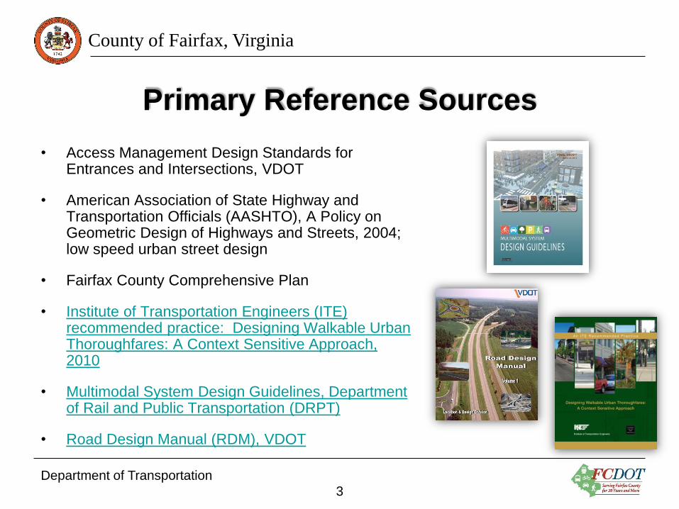
Primary Reference Sources
• Access Management Design Standards for Entrances and Intersections, VDOT
• American Association of State Highway and Transportation Officials (AASHTO), A Policy on Geometric Design of Highways and Streets, 2004; low speed urban street design
• Fairfax County Comprehensive Plan
• Institute of Transportation Engineers (ITE) recommended practice: Designing Walkable Urban Thoroughfares: A Context Sensitive Approach, 2010
• Multimodal System Design Guidelines, Department of Rail and Public Transportation (DRPT)
• Road Design Manual (RDM), VDOT
Department of Transportation
3

County of Fairfax, Virginia
Background Activities
• April 2010 – The General Assembly of Virginia enacted HB 222 (Watts), “Design standards for state secondary highway system components,” which required VDOT and the Department of Rail and Public Transportation (DRPT), to work in conjunction with Fairfax County to develop new context sensitive, urban design standards for the county.
• September 2011 – The Board adopted Transportation Design Standards and a Memorandum of Agreement (MOA) with VDOT, for the Tysons Corner Urban Center.
• May 2012 – County Staff presented to the Board an approach to developing Transportation Design Standards for the remaining urban activity districts and revitalization areas in Fairfax County.
• September 2012 – County staff met with VDOT to initiate discussions about creating county-wide urban transportation design standards for public streets.
Department of Transportation
4
County of Fairfax, Virginia
Background Activities – Continued
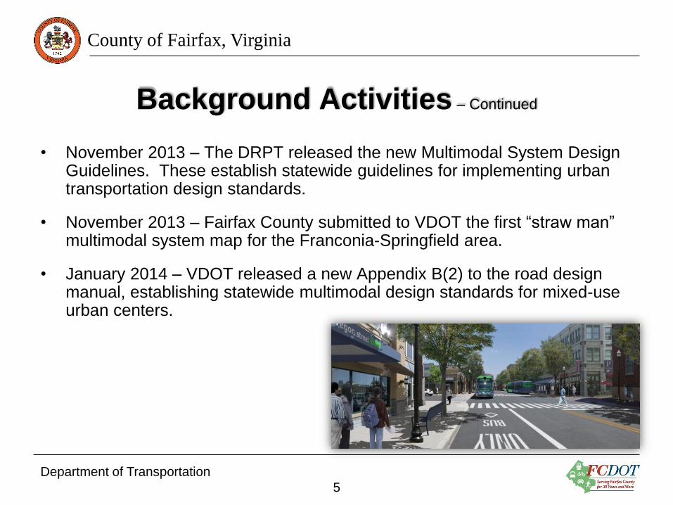
• November 2013 – The DRPT released the new Multimodal System Design Guidelines. These establish statewide guidelines for implementing urban transportation design standards.
• November 2013 – Fairfax County submitted to VDOT the first “straw man” multimodal system map for the Franconia-Springfield area.
• January 2014 – VDOT released a new Appendix B(2) to the road design manual, establishing statewide multimodal design standards for mixed-use urban centers.
Department of Transportation
5
County of Fairfax, Virginia
The Current Process
• VDOT is creating an new appendix to it’s Road Design Manual that will establish state-wide urban design criteria for urban and mixed-use activity centers and revitalization areas.
• Fairfax County is developing a GIS based multimodal system map that includes functional classifications, modes of transportation, and urban center classifications (P1-P6).
• Fairfax County will develop, based on multimodal system map, the recommended urban roadway cross sections for each roadway within the urban activity centers, and for the through corridors connecting the activity centers.
• County staff are in continued negotiation with VDOT to further develop and refine the Draft VDOT Road Design Manual urban streets standards, so that the County’s comprehensive plan can be implemented with the fewest number of design exceptions and waivers.
Department of Transportation
6

County of Fairfax, Virginia
Functional Classification Matrix
Department of Transportation
7

County of Fairfax, Virginia
Activity Centers Designations
Department of Transportation
8
County of Fairfax, Virginia
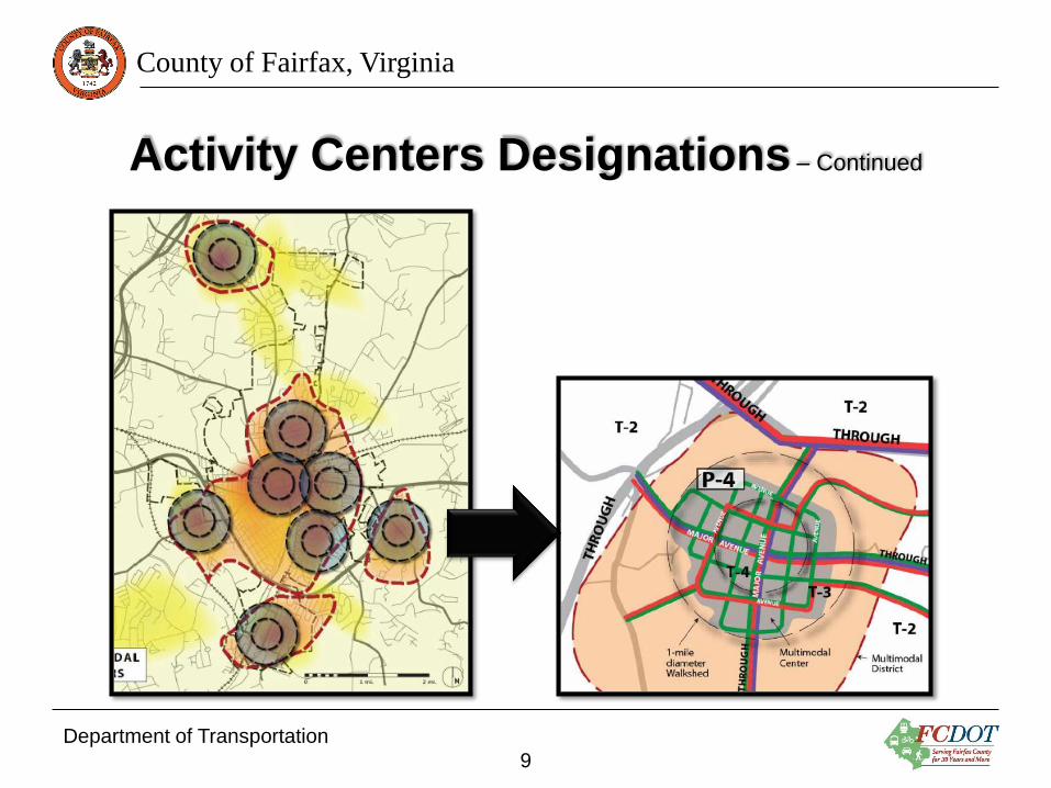
Activity Centers Designations – Continued
Department of Transportation
9
County of Fairfax, Virginia
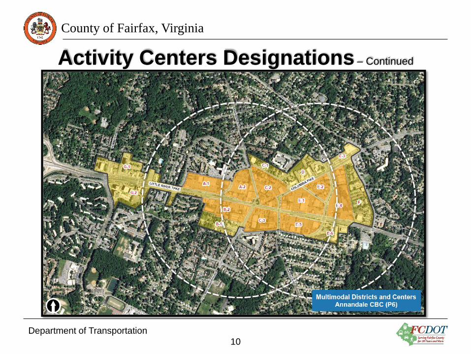
Activity Centers Designations – Continued
Department of Transportation
10

County of Fairfax, Virginia
Multimodal System Map
Department of Transportation
11
County of Fairfax, Virginia
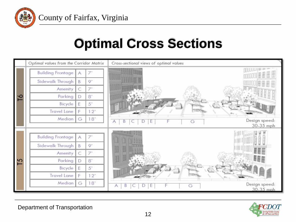
Optimal Cross Sections
Department of Transportation
12

County of Fairfax, Virginia
Modal Emphasis/Priority
Department of Transportation
13
County of Fairfax, Virginia
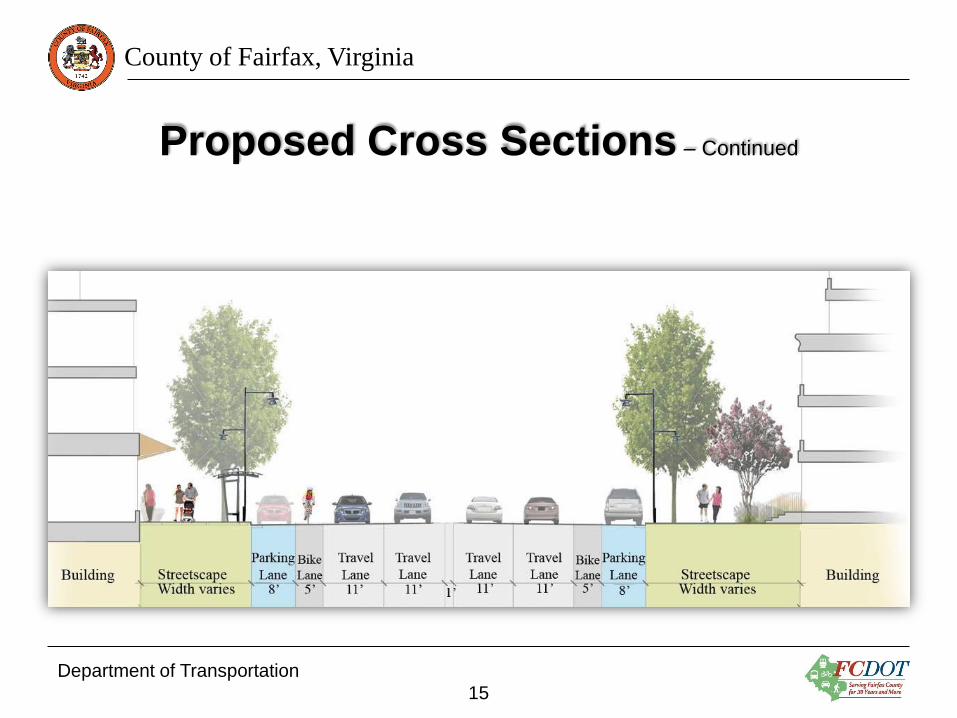
Proposed Cross Sections
Department of Transportation
14
County of Fairfax, Virginia
Proposed Cross Sections – Continued
Department of Transportation
15

County of Fairfax, Virginia
Appendix B(2)
• “Appendix B(2) serves to provide interested localities an optional mechanism within the Road Design Manual to implement the methodology of the Department of Rail and Public Transportation’s (DRPT) Multimodal System Design Guidelines and establish multimodal design standards for mixed-use urban centers.”
• The methodology contained within the Multimodal System Design Guidelines constitutes a “Complete Streets” approach.
• The methodology addresses the common limitation of constrained rights of way by affording localities additional flexibility to attempt to accommodate all transportation modes.
• Where all modes cannot be accommodated, the methodology embraces the concept of modal emphasis in which localities can identify which modes to prioritize.
Department of Transportation
16
County of Fairfax, Virginia
Appendix B(2) – Continued
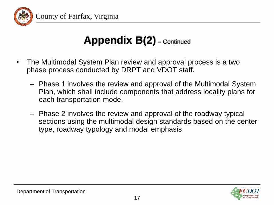
• The Multimodal System Plan review and approval process is a two phase process conducted by DRPT and VDOT staff.
– Phase 1 involves the review and approval of the Multimodal System Plan, which shall include components that address locality plans for each transportation mode.
– Phase 2 involves the review and approval of the roadway typical sections using the multimodal design standards based on the center type, roadway typology and modal emphasis
Department of Transportation
17
County of Fairfax, Virginia
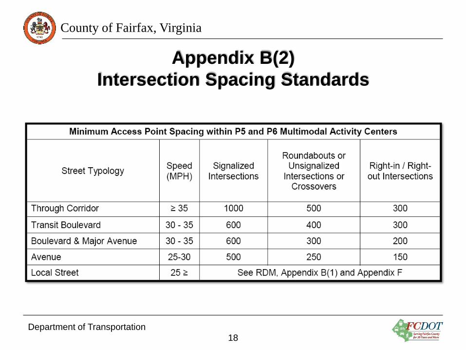
Appendix B(2)
Intersection Spacing Standards
Department of Transportation
18
County of Fairfax, Virginia
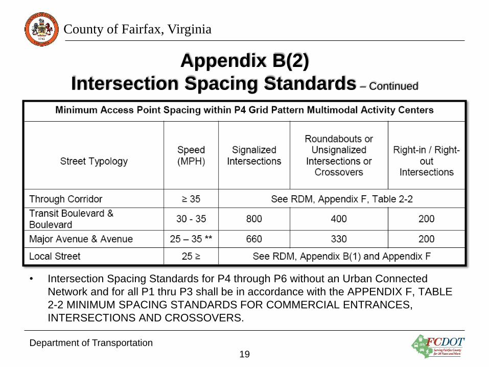
Appendix B(2)
Intersection Spacing Standards – Continued
• Intersection Spacing Standards for P4 through P6 without an Urban Connected
Network and for all P1 thru P3 shall be in accordance with the APPENDIX F, TABLE
2-2 MINIMUM SPACING STANDARDS FOR COMMERCIAL ENTRANCES,
INTERSECTIONS AND CROSSOVERS.
Department of Transportation
19

County of Fairfax, Virginia
Appendix B(2)
Stopping and Intersection Sight Distance
• Stopping Sight Distance may be used for intersection design for P5 and
P6 with Urban Connected Network for streets with design speeds of 35
mph or less as shown in APPENDIX F, TABLE 2-5 STOPPING SIGHT
DISTANCE and TABLE 2-6 STOPPING SIGHT DISTANCE ON
GRADES. However, Intersection Sight Distance shall be used for all
Multimodal Through Corridors.
• Intersection Sight Distance shall be used for all P1 thru P4 with and
without Urban Connected Network in accordance with APPENDIX F,
TABLE 2-7 INTERSECTION SIGHT DISTANCE.
Department of Transportation
20

County of Fairfax, Virginia
Appendix B(2)
Elements of a Typical Cross Section
• Bicycle and pedestrian facilities
• Parallel on-street parking
• Curb extensions (bulb-outs)
• Reduced turn-lane tapers
• Actual and effective curb radii
Department of Transportation
21

County of Fairfax, Virginia
Franconia-Springfield Pedestrian System Map
Department of Transportation
22

County of Fairfax, Virginia
Franconia-Springfield Bicycle System Map
Department of Transportation
23

County of Fairfax, Virginia
Franconia-Springfield Transit System Map
Department of Transportation
24
County of Fairfax, Virginia
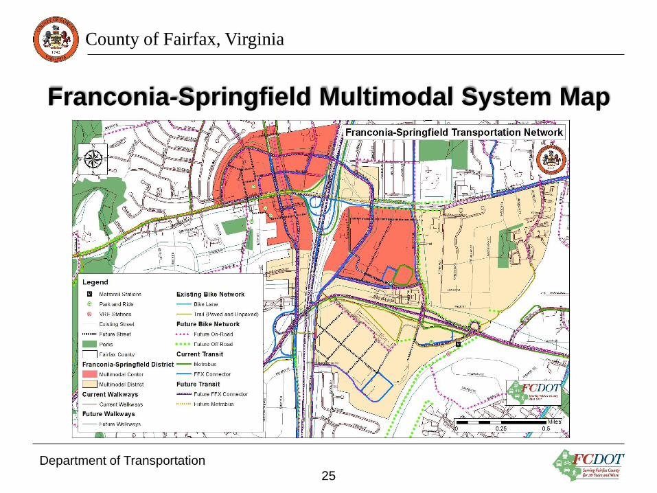
Franconia-Springfield Multimodal System Map
Department of Transportation
25
County of Fairfax, Virginia
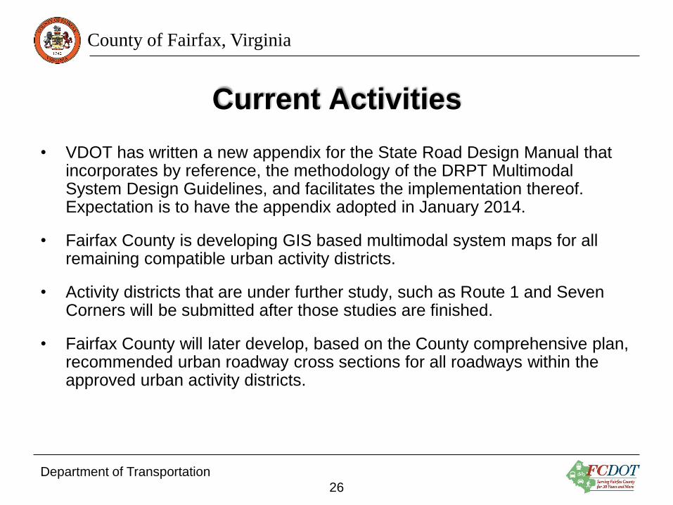
Current Activities
• VDOT has written a new appendix for the State Road Design Manual that incorporates by reference, the methodology of the DRPT Multimodal System Design Guidelines, and facilitates the implementation thereof. Expectation is to have the appendix adopted in January 2014.
• Fairfax County is developing GIS based multimodal system maps for all remaining compatible urban activity districts.
• Activity districts that are under further study, such as Route 1 and Seven Corners will be submitted after those studies are finished.
• Fairfax County will later develop, based on the County comprehensive plan, recommended urban roadway cross sections for all roadways within the approved urban activity districts.
Department of Transportation
26
County of Fairfax, Virginia
Remaining Tasks
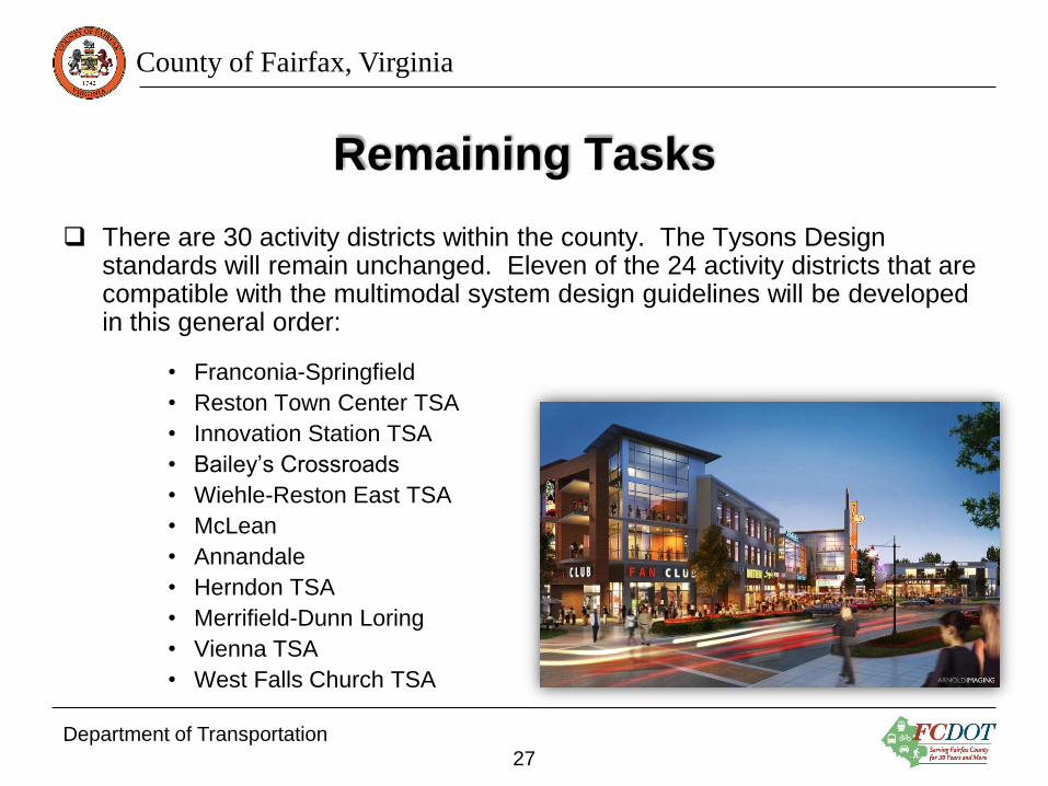
There are 30 activity districts within the county. The Tysons Design standards will remain unchanged. Eleven of the 24 activity districts that are compatible with the multimodal system design guidelines will be developed in this general order:
• Franconia-Springfield
• Reston Town Center TSA
• Innovation Station TSA
• Bailey’s Crossroads
• Wiehle-Reston East TSA
• McLean
• Annandale
• Herndon TSA
• Merrifield-Dunn Loring
• Vienna TSA
• West Falls Church TSA
Department of Transportation
27

County of Fairfax, Virginia
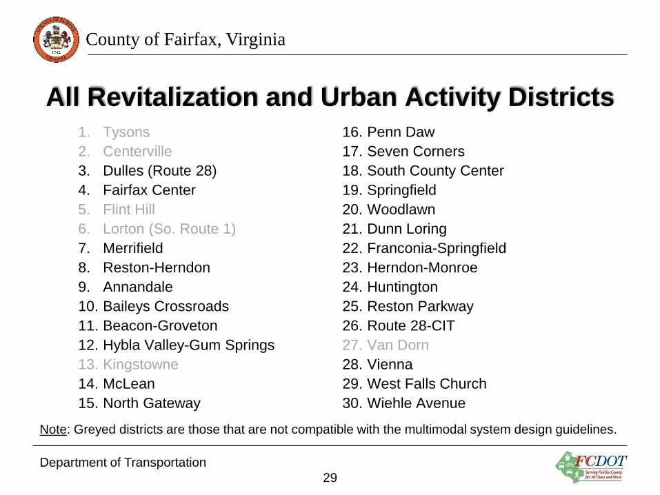
All Revitalization and Urban Activity Districts
Department of Transportation
28
County of Fairfax, Virginia
All Revitalization and Urban Activity Districts 1. Tysons
2. Centerville
3. Dulles (Route 28)
4. Fairfax Center
5. Flint Hill
6. Lorton (So. Route 1)
7. Merrifield
8. Reston-Herndon
9. Annandale
10. Baileys Crossroads
11. Beacon-Groveton
12. Hybla Valley-Gum Springs
13. Kingstowne
14. McLean
15. North Gateway
16. Penn Daw
17. Seven Corners
18. South County Center
19. Springfield
20. Woodlawn
21. Dunn Loring
22. Franconia-Springfield
23. Herndon-Monroe
24. Huntington
25. Reston Parkway
26. Route 28-CIT
27. Van Dorn
28. Vienna
29. West Falls Church
30. Wiehle Avenue
Note: Greyed districts are those that are not compatible with the multimodal system design guidelines.
Department of Transportation
29
County of Fairfax, Virginia
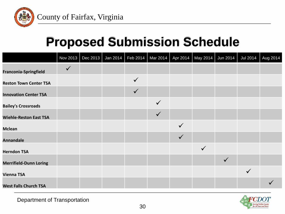
Proposed Submission Schedule Nov 2013 Dec 2013 Jan 2014 Feb 2014 Mar 2014 Apr 2014 May 2014 Jun 2014 Jul 2014 Aug 2014
Franconia-Springfield
Reston Town Center TSA
Innovation Center TSA
Bailey's Crossroads
Wiehle-Reston East TSA
Mclean
Annandale
Herndon TSA
Merrifield-Dunn Loring
Vienna TSA
West Falls Church TSA
Department of Transportation
30

County of Fairfax, Virginia
Remaining Tasks
• The preceding schedule represents the county’s anticipated submission deadlines, but does not project the actual time needed for DRPT and VDOT review and approval.
• VDOT and Fairfax County are initiating training with their staff on the multimodal system design guidelines and the proposed road design manual appendix.
• County staff expects to complete the adoption of the County-wide Bicycle Master Plan into the county’s comprehensive plan by April or May 2014. Adoption of the bike plan is required in order to generate multimodal system maps and road cross sections that incorporate bicycle facilities.
• As VDOT and DRPT complete their review of the multimodal system maps, County staff will bring the maps to the Board of Supervisors for approval.
Department of Transportation
31
County of Fairfax, Virginia
Remaining Tasks – Continued
• Once approved by the Board, staff will develop the road cross sections for those activity districts that have cross sectional information defined in the comprehensive plan.
• For those districts that do not have cross sectional information defined in the comprehensive plan, the interim default cross sections will be those adopted in the DRPT Multimodal System Design Guidelines.
• County staff may consider, at the direction of the Board, to initiate corridor studies or community plans that would eventually, through a comprehensive plan update, provide detailed cross section information for those districts. This initiative would take several or more years to complete for each district.
• County staff will be working through the implementation details of the new design standards, primarily through the land development process.
Department of Transportation
32

County of Fairfax, Virginia
Remaining Tasks – Continued
• County staff will be discussing with DPWES the possible need for an update to the County’s Public Facilities Manual (PFM), that will allow for application of the urban design standards to by-right developments.
• County staff are working with VDOT to resolve maintenance responsibilities within the County’s urban activity districts.
Department of Transportation
33
County of Fairfax, Virginia
Questions?
Department of Transportation
34