urbanization and land management issues in kosovo
TRANSCRIPT
Urbanization and land management
issues in Kosovo
- A description of the land management system and
identification of consequences in the urban planning
Fitore Regjepaj
Urbanization and land management issues in Kosovo
2
Copyright © Fitore Regjepaj
Department of Real Estate Sciences
Faculty of Engineering
Lund University
Box 118
221 00 Lund
Sweden
ISRN/LUTVDG/TVLM/16/5379 SE
Printed in Sweden

Urbanization and land management issues in Kosovo
3
Urbanization and land management issues in
Kosovo
Examensarbete utfört av/Master of Science Thesis by: Fitore Regjepaj, Civilingenjörsutbildning i Lantmäteri, LTH
Handledare/Supervisor:
Klas Ernald Borges, universitetslektor, Fastighetsvetenskap, LTH, Lunds
Universitet
Examinator/Examiner:
Ingemar Bengtsson, Fastighetsvetenskap, LTH, Lunds Universitet
Opponent/Opponent:
Karl-Oskar Fernstedt, Civilingenjörsutbildning i Lantmäteri, LTH, Lunds
Universitet
Keywords: Urbanization, Pristina, Kosovo, Land Management, Urban planning
Nyckelord: Urbanisering, Pristina, Kosovo, Markanvändning, Stadsplanering

Urbanization and land management issues in Kosovo
4

Urbanization and land management issues in Kosovo
5
Abstract This study aims to describe the structure of land management in Kosovo, and existing
issues with the current urban planning strategy in the country.
The land is currently utilized to the best extent when developing the urban area and
the system seems to move toward more necessary controls. Two specific factors have
been recognized as influencing the urban planning process. One is illegal buildings
and the other is land use changes. A general solution to the illegal buildings issue has
been legalization and planning further development with consideration to the existing
state. The other issue, changing the land use, is a formal way of labelling the land for
optimization of future usage, where changes have been more difficult to implement.
The planning documents in Kosovo did not always reflect the reality, greatly due to
that urban development often occurs at a much faster pace than the updating of
existing plans. Laws and regulations were thus sometimes hard to apply, and the
cooperation between the central and local level was not always as extensive as
desired. All investigated municipalities and institutions have room for improvement
in different ways.
This investigation gives an analysis of select institutions in Kosovo with the purpose
of identifying their strengths and weaknesses, to find points for further improvement.
In addition, this might also be of interest for international partners of Kosovo, for
further orientation around the current state of the nation regarding urbanization and
land management.

Urbanization and land management issues in Kosovo
6

Urbanization and land management issues in Kosovo
7
Sammanfattning
Plandokument är något som är vanligt i Sveriges stadsplanering, och skapandet av det
görs med stor omsorg för ett långsiktigt perspektiv och ekonomisk utveckling. Inte i
alla delar av världen har man denna fungerande struktur. Kosovo är ett av de nyaste
länderna i världen, som förklarade sig självständigt den 17 februari 2008. Kosovo har
sedan dess försökt bygga upp sin stat, till stor del med utrikes hjälp. Den urbana
utvecklingen har präglats av den process landet har gått igenom. Förbättring av
fastighetssystem, fastighetsregistrering, äganderätt m.m. har varit en del av statens
mål för att vidare kunna förvalt markanvändningen på bästa sätt. Syftet med denna
analys har varit att undersöka hur stads- och landsbygdsmark utnyttjas i ett
utvecklingsland. Hur förvaltas markanvändningen vid stadsplanering, vad tas hänsyn
till och vad ignoreras? Vilka ekonomiska vinster eller förluster uppstår till följ av
beslut? Varje steg av utveckling är viktig för Kosovo som förutom en ny stat även har
det mindre bra finansiellt.
Att utvecklas med ett långsiktigt perspektiv är det mest eftersträvansvärda för ett land.
För att göra det, behövs förutom finansiella och tekniska resurser även bidrag från det
juridiska och sociala samhället. Många beslut som tagits angående stadsutvecklingen i
Kosovo gjordes under akuta förhållanden, vilket givit många tillfälliga lösningar som
än idag lever kvar. Idag arbetar Kosovos institutioner med att förbättra de tidigare
åtgärder man gjort med målsättning att göra det mer hållbart.
För att undersöka situationen i landet har samarbete med motsvarigheten till
lantmäteriet i Kosovo gjorts, Cadastral Agency of Kosovo, samt med representativa
kommuner. Intervjuer har gjorts med valda kommuners personal och invånare samt
med representanter från staten. Kommunerna valdes delvis med hänsyn till hur
utvecklade de var, eftersom tillgång till så jämförbar information som möjligt var
eftersträvansvärt, samt med hänsyn till kommuners deltagandevilja. De utvalda
kommunerna blev tre medelstora kommuner; Fushë Kosovë, Klinë och Lipjan.
Undersökning av kommunerna visade att det politiska läget i landet hade direkt och
kortsiktigt inflytande på policys. Många samarbeten och beslut togs med politiska
partiers bästa intresse i beaktande, vilket hämmar en rättvis utveckling i landet.
Politiken spelade även roll i anställningen av nyckelposter. Detta förklarade varför
utbildning inte alltid motsvarande befattningen, samt varför kunskapen varierade stort
bland personalen i kommunerna. Bland invånarna var kunskapen inom urbanism och
markanvändning svagt utvecklad.
Med avseende på bristfällig kunskap och den sämre kvalitén av arbete bristen kan
resultera i, var tillgängliga plandokument, utvecklingsprojekt och administrativa
bestämmelser av acceptabel kvalité. Olika plandokument var ofta tillgängliga i de

Urbanization and land management issues in Kosovo
8
undersökta kommunerna och innefattade relativt bra beskrivningar, dock med
bristfälliga kartor som gav utrymme till feltolkningar. Varje kommun hade ett
planerat område där den urbana utvecklingen skulle ta plats. De hade en så kallad
urban gräns som utgjorde ett par procent av den totala kommunala arealen.
Två processer som påverkat den urbana utvecklingen är olovliga byggnader och
förändringar i planerad markanvändning. Olovliga byggnader som byggdes upp under
landets uppbyggnadsfas är idag ett hinder för optimal urban utveckling. Eftersom
rivning av dessa skulle anses som ekonomisk förlust, var lösningen att legalisera de
flesta byggnader och försöka planera stadsutvecklingen med hänsyn till dem och
deras lägen. Förändring av markanvändning är en benämning på en process som
oftast konverterar jordbruksmark till mark för bebyggelse, och kan liknas med att få
byggrätt. Denna process har dock inte allt för stora krav associerade till sig när en
sådan konvertering ansöks om, vilket har öppnat upp för privata aktörers intressen att
påverka den planerade bebyggelsen.
Förutom förluster som görs vid ombyggnationer, rivningar och hänsyn som måste tas
till illegala byggnader vid stadsplaneringen så har även andra förluster identifierats.
Frånvaron av samråd mellan institutioner samt brist på kunskap inom dessa, leder till
felaktiga och långdragna administrations- och beslutsprocesser hos myndigheter,
vilket påverkat utvecklingen och förståelsen bland invånarna negativt.
Sammanfattningsvis visar studien att det fortfarande finns mycket att göra för att
uppnå en optimal markanvändning i samband med den urbana utvecklingen, men att
markanvändningen vid urban utveckling sker på bästa möjliga sätt givet
förutsättningarna. Trots det dåliga utgångsläget verkar markanvändningen nu gå mot
ett mer kontrollerat system enligt de kommunala arbetarna. Svagt samarbete mellan
centrala och lokala nivåer har dock identifierats, vilket gör det svårare för den lokala
nivån att uppfylla de centrala kraven. Bättre stöd från den centrala sidan skulle
förbättra kvalitén i det kommunala arbetet. Viktig kunskap om de urbana områdena
saknas dock fortfarande, varför det blir svårt för Kosovo att utvecklas utan hjälp från
mer erfarna länder.
Denna analys kan vara intressant för Kosovos institutioner, i syfte att identifiera dess
brister och framgångar för att på så sätt tillåta vidareutveckling av ett system i rörelse.
Av samma anledning borde det också vara av intresse för internationella
samarbetspartner inom området att veta vad som behöver förbättras och identifiera
hjälp landet är i behov av.

Urbanization and land management issues in Kosovo
9
Përmbledhje
Dokumenti i planifikimit hapësinor është i rregullt në zhvillimin urbanistik te
Suedisë, dhe krijimi i saj behet me kujdes të madh për një perspektivë afatgjatë dhe
për një zhvillim ekonomik. Jo të gjitha vëndet e botës e kanë këtë strukturë
funksionale. Kosova është një nga shtetet më të reja në botë, e cila shpalli pavarësinë
më 17 shkurt 2008 dhe ku zhvillimi urban ka qenë i prekur nga gjendja e kaluar në
Kosovë. Një pjesë te madhe te ndihmës per te ndërtuar shtetin e ri të Kosoves, ka
ardhur nga shtetet e huaja. Zhvillime përparimtare në sistemin e pronësisë,
rregjistrimit të tokës, të drejtat pronësore, etj kanë qënë pjesë të qëllimit të shtetit për
të përmirësuar menaxhimin e mëtejshëm të përdorimit të tokës, në mënyrë që të bëhet
sa me i mirë. Qëllimi i kësaj analize ishte të shqyrtoj perdorimin e tokës urbane dhe
rurale në një vend në zhvillim. Si menaxhohet përdorimi i tokës në planifikimin
urban, cfarë është marrë parasysh dhe cfarë jo? Çfarë fitime apo humbje ekonomike
janë bërë dhe bëhen si rezultat te vendimeve që merren? Janë disa nga pyetjet të cilat
do të mundohemi ti sqarojmë në këtë analizë. Çdo fazë e zhvillimit është e
rëndësishme për Kosovën, ku përveçse është një shtet i ri, ka edhe vështirësi
ekonomike të cilat duhet të punojmë drejtë për ti eleminuar.
Zhvillimi me perspektivë afatgjatë i një shteti, është një nga mënyrat më efektive. Për
ta bërë këtë, ne përveçse kemi nevojë per burime financiare dhe teknike, duhet edhe
të përfshijmë aspektet e shoqërisë ligjore dhe ato sociale. Shumë vendime që janë
marrë në lidhje me zhvillimin urban në Kosovë, janë bërë gjatë kohës së emergjencës,
te cilat gjithashtu ishin zgjidhjet e përkohshme. Sot, institucionet e Kosovës janë duke
përmirësuar veprimet me qëllim për ta bërë zhvillimin e tanishëm më të
qëndrueshëm.
Për të shqyrtuar situatën në vend, është bërë një bashkëpunim me Agjencinë
Kadastrale të Kosovës dhe disa komuna të përzgjedhura që do të paraqesin një pamje
të përgjithshme të Kosovës. Janë zhvilluar intervista me stafin e zgjedhur të
komunave dhe banorëve të tyre, si dhe një intervistë është zhvilluar me një
përfaqësues nga subjetet shtetërore. Komunat janë pyetur pjesërisht në lidhje me
zhvillimin e tyre urban, sepse dëshira ishte që të kemi sa ma shumë informacion
krahasues, dhe pjesërisht me deshiren e komunave per të marrë pjesë. Komunat e
përzgjedhura ishin tri komuna te mesme ne Kosovë; Fushë Kosovë, Klinë dhe Lipjan.
Duke studiuar komunat e përzgjdhura, u tregua që situate politika në vend kishte një
ndikim të drejtpërdrejtë dhe afatshkurtër mbi ceshtjet vendimmarrëse në komuna.
Shumë bashkëpunime dhe vendime janë bërë nga interesat më të mira të partive
politike, duke penguar kështu zhvillim të barabartë në vend. Cështja politike
gjithashtu luajti rol në emërimin e posteve kyçe, e cila shpjegon faktin pse profesioni i

Urbanization and land management issues in Kosovo
10
lidhur me studimet e bera, nuk është gjithmonë në pozicionet e duhura. Githashtu
kishte njohuri të ndryshme në mesin e stafit të komunave.Në mesin e banorëve
njohuria për urbanizim dhe për përdorim të tokës kanë qenë të zhvilluara dobët.
Dokumentet e ndryshme të planifikimit kanë qenë në dispozicion për komunat e
perzgjedhura dhe shumë herë me një përshkrim mjaft të gjerë por nganjëherë me harta
inferior që jepte mundesinë për një kuptim të gabuar.Secila komunë ka pasur një zone
të planifikuar për zhvillimin urban, e quajtur zona urbane, e cila përbëhej nga një
përqindje e vogël e sipërfaqes së përgjithshme të komunës.
Dy procese që kanë ndikuar në zhvillimin urban ne Kosovë, janë ndërtesat ilegale dhe
ndërrimi i destinimit te tokës së planifikuar. Ndërtimet pa leje janë ndërtuar ne fazën e
emergjencës dhe sot janë pengesë për zhvillimin optimal urban. Duke qënë se rrënimi
i tyre do ishte humbje ekonomike, zgjidhja e kesaj cështjeje ishte që të legalizohen
shumica e ndërtesave dhe të përpiqen për të planifikuar zhvillimin urban në lidhje me
të dhe pozicionet e tyre. Ndërrimi destinimiti të përdorimit të tokës është një proces
që zakonisht përdoret për të ndërruar token bujqësore në atë të ndërtimit. Ky proces
nuk ka kërkesa të shumta për të bërë një ndryshim të tillë, ngaqë klasifikimet e tokave
nuk janë edhe aq te larta. Kjo arsye ju ka dhënë operatorëve privat mundësinë për të
ndikuar në ndërtimet e planifikuara.
Përveç humbjeve që bëhen për çdo rindërtim, shkatërrim apo shikim që duhet të behet
për ndërtime pa leje, janë identifikuar edhe disa humbje të tjera në planifikimin urban.
Mungesa e konsultimeve mes institucioneve dhe mungesa e njohurive, rezulton në
vendime të gabuara dhe procese të zgjatura të qeverive vendimmarrëse, të cilat
ndikojnë negativisht në zhvillimin dhe kuptimin tek banorët.
Në përmbledhje, studimi tregon se ka ende shumë për të bërë për të arritur një
përdorim optimal të tokës në lidhje me zhvillimin urban, por që përdorimi i tokës
zhvillohet në mënyrën më të mirë të mundshme, duke pasur parasysh kushtet.
Pavarësisht se fillimi i menaxhimit të tokave nuk ka qenë aq i mirë,sipas punëtorëve
të komunës, duket se përdorimi i tokës tani është duke shkuar drejt një sistemimi të
kontrolluar që më parë. Bashkëpunime te dobëta janë identifikuar ndërmjet nivelit
qendror dhe lokal, duke e bërë më të vështirë për nivelin lokal për të përmbushur
kërkesat thelbësore. Mbështetje më të mirë nga pjesa qëndrore do të përmirësonte
cilësinë e punës së qeverisjes lokale. Njohuri të rëndësishme per zona urbane ende
mungojnë, dhe është ajo pikërisht që e ben te vështirë për Kosovën që të zhvillohet pa
ndihmën e shteteve te huaja që kanë më shumë njohuri.
Kjo analizë mund të jetë interesante për institucionet e Kosovës, në mënyrë që të
identifikohen mangësitë dhe sukseset e saj, dhe kështu të lejojë zhvillimin e
mëtejshëm të sistemit në lëvizje. Për të njëjtën arsye, duhet po ashtu të jetë ne interes
për partnerët ndërkombëtarë në terren, per te kuptuar se çfarë duhet të përmirësohet
dhe për të identifikuar ndihmë per te cillat vendi ka nevojë.
Urbanization and land management issues in Kosovo
11
Acknowledgements
I would like to gratefully acknowledge various people who had been a part of my
journey and, without whose cooperation and achievement this thesis would not be
done.
First of all, I want express my gratefully acknowledge to SIDA, Swedish International
Development Agency, who gave me the opportunity to implement the field studies for
this thesis in Kosovo through the Minor Fields Studies Program.
Furthermore I want to thank Kosovo Cadastral Agency and its staff for cooperation
and support I got. Especially thanks goes to Mr. Muzafer Qaka and Mr. Qazim
Sinani.
Thanks are also due to the representatives from the urban department in the
municipalities Fushë Kosovë, Klinë and Lipjan, the represantaitve from government
Agim Radoniqi, and friends and family for all help and support during the stay in
Kosovo.
I also want to thank my supervisor Klas Ernald Borges at the Department of Real
Estate Science at Lund University for the help and support.
Lund, June 2016
Fitore Regjepaj

Urbanization and land management issues in Kosovo
12

Urbanization and land management issues in Kosovo
13
Abbreviations
AMMK Agjensioni per mbrojthen e mjedisit te Kosoves (Eng. The agjency of
environmental protection in Kosovo)
ASK Agjensia e statistikave të Kosovës (Eng. Kosovo Agency of Statistics)
KCA Kosovo Cadastral Agency
MFAKS Ministry of Foreign Affairs Kosovo
MMPH Ministria e Mjedisit dhe Planifikimit Hapsinorë (Eng. Ministry of
environment and spatial planning)
RKS Republic of Kosovo

Urbanization and land management issues in Kosovo
14
Urbanization and land management issues in Kosovo
15
Table of content
1. Introduction ......................................................................................................... 19
1.1 Background ................................................................................................. 19
1.2 Purpose ........................................................................................................ 20
1.3 Methodology ............................................................................................... 20
1.4 Limitations .................................................................................................. 21
1.5 Disposition of the thesis .............................................................................. 22
2. Theoretical framework ........................................................................................ 23
2.1 Concept of urbanization .............................................................................. 23
2.2 Urban zoning and borders ........................................................................... 24
3. Kosovo in a historical and development context ................................................ 27
3.1 Short history of Kosovo .............................................................................. 27
3.2 Geological information ............................................................................... 28
3.3 History of the urbanization in Kosovo ........................................................ 29
3.4 Land management in traditional way .......................................................... 31
3.5 Land management in general ...................................................................... 34
3.6 Comparing other counties in Balkan and Eastern Europe .......................... 35
4. Government structure and administration in land management .......................... 39
4.1 Municipal structure and administration ...................................................... 39
4.2 Planning system .......................................................................................... 42
4.2.1 Planes on central level ......................................................................... 42
4.2.2 Plans on local level ............................................................................. 45
4.3 The process of changing the land type ........................................................ 48
4.4 The Kosovo Cadastral Agency.................................................................... 51
5. Background to the field work .............................................................................. 53
5.1 Investigation in some municipalities in Kosovo ......................................... 53
5.1.1 Fushë Kosovë ...................................................................................... 53
5.1.2 Kline .................................................................................................... 57
5.1.3 Lipjan .................................................................................................. 60
6. Field work ........................................................................................................... 67
Urbanization and land management issues in Kosovo
16
6.1 Methodology ............................................................................................... 67
6.2 Interviews .................................................................................................... 68
6.2.1 Interviews with inhabitants ................................................................. 68
6.2.2 Interview with representative from the government ........................... 71
6.2.3 Interview with representatives from municipalities ............................ 72
7. Analysis of the system of land management and urbanization ........................... 75
8. Conclusion .......................................................................................................... 81
9. References ........................................................................................................... 87
Literature ................................................................................................................. 87
Online Sources ........................................................................................................ 88
Documents .............................................................................................................. 90
Legislative text ........................................................................................................ 91

Urbanization and land management issues in Kosovo
17

Urbanization and land management issues in Kosovo
18

Urbanization and land management issues in Kosovo
19
1. Introduction
1.1 Background The republic of Kosovo is one of the newest countries in the world, declaring its
independence on 17th February 2008. The history of Kosovo broadly consists of
worried political governance, ending with a war in 1999. Kosovo as a part of the
Federation of Yugoslavia before the war, became transitionally administrated by UN
until it declared its independence. The conflict in 1999 caused, among other things,
destruction of large parts of the urban environment. At the time, acute actions for
settling returning refugees largely ignored optimization of land use and urban
development.
Rebuilding activities, newbuilding, post-conflict rural and urban migration,
resettlements of the population, all helped to cause the formation of an informal
neighbourhood1 which is reflected in the land management of many municipalities in
Kosovo. Informal exploitations of land presents problems at the local level in the
development of urban and rural areas. This also creates problems within the central
level in upholding state legislature, not being able to apply its rules in real life, far
away from the theoretical description. Furthermore this also have effects on the
economic development in the country.
After the war ended, Swedish authorities were some of the first who initiated aid to
Kosovo, in order to gradually create new and develop existing functional authorities.
This served the purpose of boosting economic development in the country and one of
the Swedish authorities' priorities in Kosovo was to contribute to the development of
the real estate market, which is vital for a sustainable economy. An important basis to
achieve economic development in the real estate market is to use land efficiently and
the authority functions were thus heavily concerned with real estate markets, urban
planning and taxes.
The agricultural land has always been an impediment to the urban environment
development. Some land could be used profitably as agricultural land, but because of
the successive expansion of the urban border it has buildings on it. On the other hand
there might exist land where urban development would be more natural, but the
location is less appropriate, e.g. outside the city/urban border.
The development of urban planning and general land management requires
knowledge, technical equipment, finance but also a functioning and accountable
1 Grant, Jude Garstka (2009)

Urbanization and land management issues in Kosovo
20
government. The current issue of land management during development of urban
areas is quite difficult to manage on a local level.
In a densely populated region such as Kosovo development of land for urban purpose
plays a major role in the estate market in the country. One of the most
current issues is cities built without regard to the quality of the agricultural land and
sometimes in an illegal way. Because of this uncontrolled urban expansion, the
agricultural land is not optimally utilized. Kosovo has good potential for successful
agriculture in the fertile lands available in the country. This could generate higher
yield if more knowledge, equipment and finance would exist and was used.
1.2 Purpose The purpose of this thesis is to investigate and analyze the enforcement of urban- and
rural land management in Kosovo, a country under development, to identify the
problematic parts of the urban development. The challenge in this study is to identify
efficiency of land use in Kosovo and, the reasons to the lack of efficiency.
1.3 Methodology In cooperation with the Kosovo Cadastral Agency (KCA) and select municipalities in
Kosovo, I studied the efficiency of land use and how the country manages and
controls their areas. What requirements exist for the change of land-use and contrarily
what are the requirements for keeping the ongoing land use. What is the official
procedure for changing land use, and how does it work in practice? Furthermore,
identification of socioeconomic losses due to uncontrolled ways of changing and
managing the land use in a long-term perspective will also investigated.
The analysis will touch upon legal, economic, technical, and social aspects. Analysis
will entail how land use is defined in the rural and urban land regarding legislation.
The economic perspective is analyzed on the basis of the economic perspective of
national, local and private interaction. Furthermore, the inhabitants act in different
situation and how absence of information and education can be an impediment of
understanding and value new systems and laws. Technical aspects include the use of
maps and databases for real estate systems.
To understand the situation, and hopefully find solutions for some hinders on the way
out of the problematic situation, the system and laws have to be known. The study

Urbanization and land management issues in Kosovo
21
will therefore investigate different municipalities with respect to the planning system
and laws in Kosovo.
Reports, maps and plans at selected municipalities in Kosovo were used to examine
the issue from a regional perspective. I also worked together with KCA to get an
overview of legal aspects and their function. In addition, I studied how
representatives from the government viewed the situation, and their thoughts about
possibilities of improvement. In addition to fieldwork I used reports/articles about the
real estate ownership, urban planning, formalization of informal development and
the delineation of urban/rural land in the Balkans. Also I did use articles about post
conflicts urban planning and land management. The literature review was linked to
the field analyses to couple relevant facts to the study.
The population's views were taken into consideration through interviews with
randomly selected middle aged individuals in the municipalities where the fieldwork
was conducted. This type of selection was made to ensure that the selected
individuals owned any property and had been affected by the urbanization, directly or
indirectly. Interviews with representatives from government agencies and local levels
were more selectively selected and were conducted to broaden the perspectives and
problematic situation. Occasionally was recommended by partners to contact
To collect the necessary data, eight weeks of fieldwork in February and March 2016
was spent in Kosovo. Initially I started to investigate the legal processes, the
underlying problems and the programs of development on a central level, identified
from the KCA, located in the capital city of Kosovo, Pristina. Thereafter I searched
for information on local level, in the municipalities and by inhabitants. To get as
much information as possible, I chose to study middle sized municipalities with
relevant information to share. I contacted tens of municipalities in Kosovo through
emailing and phoning the head of the urban planning in each municipality. The ones
who answered and accepted the cooperation became the municipalities Fushë Kosovë,
Lipjan and Klinë. Weeks were placed in the municipalities, both in cities and in the
municipal building. The final of the fieldwork were dedicated for interviews with the
population, but also with a representative from the central government.
1.4 Limitations The study was limited to a few middle-sized municipalities with an urban
development. The purpose of this was to describe how urban development and land
management works outside the primary centers in the country. Therefore I did not

Urbanization and land management issues in Kosovo
22
choose one of the bigger cities to be investigated, because they have more factors
affecting the development and land use.
Likewise, this study will not investigate the population growth and displacement in
urban areas. It will be mentioned as a reason for urban growth, but not how much it
has affected the studied municipalities.
Interviews with Nongovernmental organization (NGO) including construction real
estate and agricultural businesses were unfortunately not carried out despite intention
of it, due to lack of opportunity from their behalf. This would have given a wider
description of the situation and perhaps also information about cooperation between
governmental and NGOs.
1.5 Disposition of the thesis A theoretical background is presented by analyzing the current system. The history
and culture of Kosovo will be introduced to give a better understanding of the current
situation and how the end of the war created a new era for the development in
general.
The thesis describes how the urbanization is practiced today, introduction of laws and
what type of problems the citizens, the administrations and how people in general are
affected by urbanization. This concept is deepened by reviewing reports, plans, maps,
and through interviews from the field. Results of these are presented subsequently.
Following this, a discussion of the challenges and conclusions of the thesis are laid
out and finally some recommendations are given about how to make land
management more efficient in the process of urbanization, for a country under
development.
Urbanization and land management issues in Kosovo
23
2. Theoretical framework
2.1 Concept of urbanization Urbanization is described as a concept of change. Change that increase the share of
the urban subset by redistribution of a population. Urbanism (urban mode of life)
also refers to cultural traits which follows the process of development2, and can
therefore be different in different parts of the world.
Urbanization has in many everyday contexts defined the difference between “urban”
and “rural”. This division of two areas have made it both easy to understand and
identify the term urbanization. Meanwhile, in the scientific world it has been more
difficult to define the meaning of the term. The question of the definition seems to be
whether the possibility of a redistribution of a population is necessary for the urban
society to occur3.
Falk, uses generally accepted definitions of the terms urban and rural referring to the
city contra the country or the areas outside the city. The city is mostly described
through high buildings, roads, different businesses and large spaces that refers’ to
large number of people. On the contrary, the nonurban place is considered as less
developed, with more individual homes, less high buildings, and limited human
activities etc.
The places refer to how people settle themselves in different ways of living, which in
a longer time-span form a society. Even though these two completely different
societies live in different ways, they still depend on one another.
People need land to produce food and other resources that are necessary for living. By
living in the dense cities, one is separated from the land which produces food. So why
do cities exist? In the technological world which the human race has created, systems
of production and exchanges exist that seems to challenge the natural order4.
O’Sullivan emphasizes three conditions that must be satisfied for the city to develop.
These conditions are:
Agricultural surplus. People outside cities must produce enough
food to feed themselves and city dwellers
Urban production. City dwellers must produce something – goods or
service to exchange for food grown by rural workers.
2 Falk, Thomas (1976) p.4
3 Falk, Thomas (1976) p.5
4 O’Sullivan, Arthur (2012) p. 3ff.
Urbanization and land management issues in Kosovo
24
Figure 1: Source: FIG-Publications, No. 33, 2014
Transportation for exchange. There must be an efficient
transportation system to facilitate the exchange of food and urban
products5.
For these conditions of the cities to be fulfilled, we must manage the land we have
available efficiently in order to maximize both the agricultural and the urban
production.
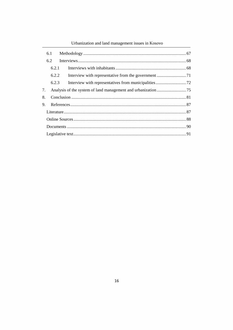
To create sustainable rural and urban conditions there must also be a balance between
good governance and good land policy. This will be described further in the study.
From a published article Stig Enemark shows this relationship in graphic (Fig. 6).
2.2 Urban zoning and borders The government’s role in managing land use is often reflected in the planning and
zoning of cities. When planning cities, land use is regulated by laws and rules for the
planning system. The zoning plans become an aid for segregating different types of
land use into separated zones. These separated zones usually include commercial,
industrial and residential areas. Kosovo uses the zoning as a method to control the
urban growth and the planning of the zoned areas. Planning the cities with zoning
5 O’Sullivan, Arthur (2012) p. 3-4

Urbanization and land management issues in Kosovo
25
helps the city to define its borders and control the growth. This will be described
more closely further in the thesis.
The history of zoning took place in the early 20th century in the United States, were
they used orders to control land use in particular areas. Orders were created by shared
opinions from the inhabitants, such as blocking light and view from a high building,
which subsequently generated regulations for tall buildings. The comprehensive
zoning map was at first regulated in 1916 in New York. In the same year eight other
cities had implemented a zoning map. Twenty years later, the zoning map was spread
to more than a thousand cities7.
Zoning can be used for many valuable reasons in the land use development. Firstly,
zoning can be used as an environmental policy which should separate pollution
sources from the residential areas. Secondly zoning can be used as an incentive to
make sure those households or firms generate fiscal surplus, which occurs when taxes
for the land users pass the cost of public services provided.8 Negative externalities
from different industry or commercials zones will be better accepted if they would
provide a fiscal surplus for the region or the municipally. Every intent of
development, in general, aims to increase such profit in different ways.
The regulation for zoning is placed on a central level where rules are formed to guide
and control the local government work. The central level’s interest is to manage local
government right and equally with rules, education and financial equipment to
manage their area as good as possible.
While zoning control the way of using the land inside a specific area such as a
municipality, there are borders that are aimed to control the city-growth. Growth
boundary is one of the policies cities use to control their development in both land
and their population. These boarders can on the one hand be developed by restricted
urban services in a city, such as roads, services etc. On the other hand they can also
be developed through conditions that forbid development beyond a growth boundary
which comprises an area determined for urban development. 9
7 Ibid p. 230 ff
8 Ibid p. 232
9 O’Sullivan, Arthur (2012) p. 232 ff

Urbanization and land management issues in Kosovo
26

Urbanization and land management issues in Kosovo
27
3. Kosovo in a historical and development context
3.1 Short history of Kosovo The Republic of Kosovo is the youngest country in Europe, located in south-eastern
Europe bordering Albania, Macedonia, Montenegro and Serbia. The country has an
area of 10, 908 km2 (approx. the size of Skåne, Sweden) with a population of about
1.8 million inhabitants10 11
and with the relatively young median age of 28.2 years12
.
The capital of Kosovo is Pristina (alb. Prishtina) with about 200,000 residents in
2011. The ethnic origins of Kosovo’s population is 88% Albanian, 7% Serbs and 5 %
other small ethnical groups such as Turk, Bosnian, Goran, Roma, Ashkali and
Egyptian. The official languages are Albanian and Serbian. In certain places were the
majority of the population belong to one of the minorities, their tongues can also
occur as official language. Kosovo has a climate characterized by hot, dry summers
and cold winters. Abundant natural resources are lignite, lead, zinc, chromium etc.
and export products include base metals, minerals, machinery and leather. Important
sources of income include trade, services, agriculture, some mining and remittances13
.
Nevertheless, Kosovo is one of the poorest countries in Europe, with more than one
third of its population considered poor14
. Poor is defined as living below the
International Poverty Line, which The World Bank set in October 2015 at US $ 1.90
per day15
, corresponds 15,24 SEK (May, 2016)16
. About 30 % of the population is
unemployed and the GDP per capita was €3103 in 2014. Large parts of the population
live from working in the agricultural sector, which is one of the main sources of
income for the economy in Kosovo17
. Thereby, it is in the state of Kosovo’s best
interest that the municipalities regulate the rural land as effectively as possible as
cities rebuild and develop.
The country declared itself as an independent country in 17 February 2008, from the
Republic of Serbia. Years of strained relations between Albanians and Serbs in this
area lead to the outbreak of full scale war in 1998, which forced 1.5 million of
10 Swedenabroad (2016) 11
CIA (2016) 12
Ibid 13
Swedenabroad (2016) 14
SIDA (2015) 15
Worldbank (2015) 16
Valuta (2016) 17
Swedenabroad (2016)
Urbanization and land management issues in Kosovo
28
Kosovo’s then 2 million inhabitants to flee as refugees. A big share fled to the
bordering countries Makedonia and Albania. Other chose a longer path, to Europe,
America and even Australia.
The Serbian troops were driven out from Kosovo in June, 1999 by the United Nations
(UN) who took over the administration of Kosovo. The Security Council of UN
declared a resolution for Kosovo, Resolution 1244, for international civil presence in
Kosovo – The United Nation Interim Administration Mission in Kosovo, UNMIK.18
This resolution put Kosovo under transitional administration, waiting for a
determination of the country’s future-status.
In 2004 the UN decided to step-up focus on the future of Kosovo, and as a result the
Finnish President Martti Ahtisaari proposed Kosovo becoming independent under
international supervision in 2007, after which Kosovo declared itself independent in
2008. In connection with the independence, the European Union, EU established a
mission of police, customs and judicial authorities called EULEX, whose jobs were to
strengthen the new country’s capacity in the legal area, corruption and war crimes19
.
Today Kosovo is recognized as a country by over one hundred of UN’s 193 countries,
including Sweden, although neither Serbia nor the UN has recognized the
independence yet. In some municipalities along Kosovo’s northern border Serbs are
in majority. These often contest the final status of the country, wanting no change in
the regime and belonging. The government of The Republic of Kosovo is today
dealing intensely with challenges within the parliament, were the sitting government
and the opposition are disagreeing in questions about land borders and the rulership of
the municipalities in Kosovo populated with minority groups.
Kosovo is not yet member of any international organization such as UN, EU or
NATO. Since it is a relatively new state and not recognized by all the members in
EU, relations between them are hindered, although EU is still Kosovo’s largest
benefactor. NATO have their international forces KFOR (Kosovo Force) in Kosovo,
which has the responsibility for security in the country, with troops amounting to
5000 men in 2013.
3.2 Geological information Kosovo is located in Eastern Europe and is characterized by the central position of the
peninsula of Balkan. The country is surrounded by high mountains, some mountain
18
UN (2011) 18
Ibid
Urbanization and land management issues in Kosovo
29
peaks exceeding 2000 m altitude, which have different geological composition. In the
middle of the mountains, two large plains stretch out. One of Dukagjin, the other of
Kosovë. The Highest peak in Kosovo is Gjeravica with 2 656 m20
.
The mountains do not isolate Kosovo from the
surrounded countries, because in the four
corners of the country, there are rivers. These
wide and deep rivers overcome these natural
barriers and connect the inland of the Balkan
Peninsula to the Mediterranean Sea.
Through its territory important highroads pass
which link the middle of Europe with the coast
of the Mediterranean Sea coast. This gives
Kosovo a strategic position in this part of
Europe.
The country’s good geographic position allows
a variety of natural elements such as; geological
compositions, landscape, climate, hydrography,
vegetation and different soil types. Furthermore good mineral resources that provides
a good basis for economic development. Agriculture is the main economic activity,
with great agrarian access, but with insufficient mechanization and inappropriate
structure for cultivating. The land areas of Kosovo consist of 53 % agricultural land
and 39.1 % forestry. The remaining areas are constituted by urbane zones and water
surfaces. About half of the agricultural land (52.3 %) is arable, while one third (31 %)
is used for pasture and corn21
.
3.3 History of the urbanization in Kosovo The urbanization in Kosovo can be defined in two eras, one between 1970 and 1999
and the other from 2000 and further. The first era is defined from the beginning of the
migration from rural to urban. This period was a worried time in Kosovo, where
people fought for surviving and even decided to flee the country. The development of
the cities was not a priority at that time, but they managed to develop the urbanization
plan for Kosovo and its’ municipalities for a period between 1975 and 200022
. This
plan defined the period of the first era, which ended with the war in 1999 and was the
final for much historical problems and obstacles in Kosovo’s development. The
second era, year 2000 and further, reflects the time of rebuilding and building up new
20
Government of Kosovo, The Ministry of Environment and Spatial planning (2010) 21
Ibid 22
Ministira e Mjedisit dhe Planifikimit Hapësinor (2002)
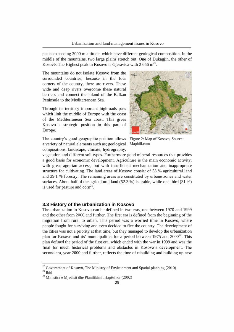
Figure 2: Map of Kosovo, Source:
Maphill.com

Urbanization and land management issues in Kosovo
30
things that should develop the new and free country. It is a period where people
moved back to their homes, but also a time for a rebuilding process of new
administration and state-functions that should lead the territory of Kosovo to a final
state.
Urbanization is not just about changing different land areas, it should also consider
the development of economics, social, cultural and environment. Through the spatial
planning, the system of the urban growth is being prepared to take responsibility for
the planning’s priorities and the decisions that should be made. Nowadays
development in Kosovo is a consequence from the long-lasting conflict which began
in a greater occurrence in the late 80s, with falling economy and destruction of
Yugoslavia. Today there are seven new countries (Slovenia 1991, Croatia 1991,
Macedonia 1991, Bosnia and Hercegovina 1992, Montenegro 2006, Serbia 2006 and
Kosovo 2008) created from the Yugoslavia federation. These countries all became
independent through armed conflicts. All these countries including Albania are
handling land management problems including informal urban development, property
problems and illegal building.
The conflict which was going on for a decade in the former Yugoslavia, puts all the
countries, including Kosovo in a situation of total degradation of system, losses in
economy and shortage of labour, which made the process of reformation more
difficult. The trade, transport and tourism were prevented a lot from the conflict,
which affected the economy development in each country. Furthermore the conflict
also caused a loss of trust by foreign investors23
.
Prior to the conflict, Kosovo had its natural resources, minerals and rich agricultural
land. The economic activities have been focused on industry and agriculture during
the two last decades. More than 60 % of the population lived in the rural zones, which
occupies oneself with agricultural production. Despite the natural resources, the
region of Kosovo was the poorest in the former Yugoslavia’s territory, and became
worse when the regime of Yugoslavia began to be violence to the Albanians. In the
70-80s, every property of a company owned by Albanians was forcefully overtaken
by a Serbian. This was a strategy from the Yugoslavian’s regime to move Kosovo-
Albanians away from Kosovo, so that the territory could establish a Serbian majority.
The drastic decline of the economy, led the Kosovar-Albanians to flee the country
and settle down in the neighbouring countries and other countries, both before and
during the conflict24
.
According to the assessment of the Department of Reconstruction – UNMIK, about
120,000 houses and auxiliary house buildings were fully or partially damaged during
23
Kuvendi Komunal Fushë Kosovë (2004) p. 9 24
Ibid p. 10
Urbanization and land management issues in Kosovo
31
the war 1998/99. Close to 60 000 were rebuilt by the end of 2002 from donors, the
rest was rebuilt by families. In 2003 there were about 360,000 residential buildings of
all type, in which about 2.04 million inhabitants lived. In comparison, in 2003 there
were 139,000 residential buildings. The migration of families to both medium and
larger cities but also high birth-rates, are two main factors which have increased the
demand for housing after the war. In Pristina the urban zone has increased from 450
ha to 1500 ha in a period of 20 years (1980-99)25
. This was before the huge post war
transition in Kosovo.
The economic development has since the end of the conflict begun to rise, but is still
rather low. Available statistical data is divided into three categories, statistics before
90s, statistics in 1991-1999, and statistics after 1999. The statistics before the 90s,
was from a period where the state’s institutions were in working order, and could be
considered credible. The statistics in the period between the years 1990 and 1999 is in
some parts considerate deficient, and in others, not reflecting the reality in Kosovo.
After the war, the state’s institutions begun mostly to work in order and are
considered credible again.
A spatial plan for the urban development from 1975 valid until 2000, was no longer
valid after the war. New plans which were acutely developed after the war were
divorced from the reality in Kosovo and were not very useful. This made it more
difficult for the spatial planning on a local level. In absence of planning maps a huge
growth of unplanned residential areas, followed by property issues, building on
agricultural land at the cost of the environment became a part of the daily
development.
The head of urban planning in Kosovo is located at the central level at the Ministry of
spatial planning and environment.
3.4 Land management in traditional way Even though there are laws legislated by the government, the behaviour and actions
of individuals in different occasions often reflect the nation’s traditions and culture. It
is the culture and tradition that has been a rival against the national laws, in the
beginning of building the new country. The concepts and understanding of urbanism
is in general quite low in the country and only a few professionals are trained in the
subject. It is clear that urban places and their development are controlled by a spatial
plan. In other places, such as in the villages, far away from the city, where the
training in urbanism is more limited and there is no plan that regulates the land use, it
is common that traditional regulations are being used. Certain traditional regulation
will be described further on.
25
Kuvendi Komunal Fushë Kosovë (2004) p. 10
Urbanization and land management issues in Kosovo
32
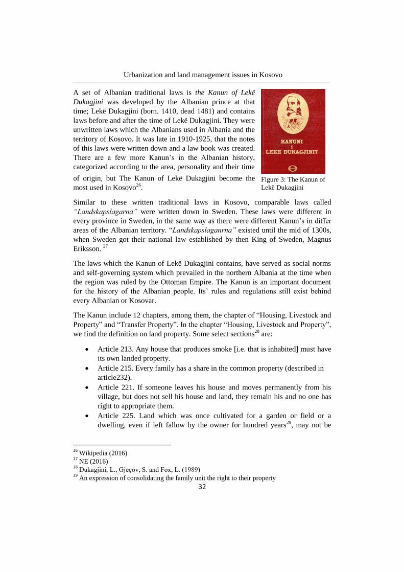
A set of Albanian traditional laws is the Kanun of Lekë
Dukagjini was developed by the Albanian prince at that
time; Lekë Dukagjini (born. 1410, dead 1481) and contains
laws before and after the time of Lekë Dukagjini. They were
unwritten laws which the Albanians used in Albania and the
territory of Kosovo. It was late in 1910-1925, that the notes
of this laws were written down and a law book was created.
There are a few more Kanun’s in the Albanian history,
categorized according to the area, personality and their time
of origin, but The Kanun of Lekë Dukagjini become the
most used in Kosovo26
.
Similar to these written traditional laws in Kosovo, comparable laws called
“Landskapslagarna” were written down in Sweden. These laws were different in
every province in Sweden, in the same way as there were different Kanun’s in differ
areas of the Albanian territory. “Landskapslaganrna” existed until the mid of 1300s,
when Sweden got their national law established by then King of Sweden, Magnus
Eriksson. 27
The laws which the Kanun of Lekë Dukagjini contains, have served as social norms
and self-governing system which prevailed in the northern Albania at the time when
the region was ruled by the Ottoman Empire. The Kanun is an important document
for the history of the Albanian people. Its’ rules and regulations still exist behind
every Albanian or Kosovar.
The Kanun include 12 chapters, among them, the chapter of “Housing, Livestock and
Property” and “Transfer Property”. In the chapter “Housing, Livestock and Property”,
we find the definition on land property. Some select sections28
are:
Article 213. Any house that produces smoke [i.e. that is inhabited] must have
its own landed property.
Article 215. Every family has a share in the common property (described in
article232).
Article 221. If someone leaves his house and moves permanently from his
village, but does not sell his house and land, they remain his and no one has
right to appropriate them.
Article 225. Land which was once cultivated for a garden or field or a
dwelling, even if left fallow by the owner for hundred years29
, may not be
26
Wikipedia (2016) 27
NE (2016) 28
Dukagjini, L., Gjecov, S. and Fox, L. (1989) 29
An expression of consolidating the family unit the right to their property
Figure 3: The Kanun of
Lekë Dukagjini
Urbanization and land management issues in Kosovo
33
occupied or worked by anyone else in the village or Banner (someone with
the same flag – nationality). It passes from son to son of the first owner.
Article 232. Common property is the area held in common by the village or a
Banner for pasture, timber, firewood, hinting and other needs.
Article 234. One person, without the other (inhabitants in the village), may
not sell the wealth of the common property; its loss and profit belong to all
the households of the village or the Banner.
Even though the articles are outdated, the laws still can be reflected in the current
laws and inhabitants’ behaviour.
The 13th chapter of The Kanun of Lekë Dukagjini handle the land boundaries. Some
articles selected in this chapter reflect a part of the Albanian tradition in land
management.
Article 238. The boundary is constructed with large, peaking stones thrust
into the earth and exposed above it. An aged tree may also serve as a
boundary.
No one ever thought about moving the stones. Article 239 says “The
boundary stone has witness behind it”. In the view of the Kanun, the bones of
the dead and the boundary stone are equal. To move the boundary is like
moving bones of the dead, says Article 243 (i.e. unacceptable).
Article 252. In order to avoid any misunderstandings, the boundary does not
twist and turn or zig-zag, but must go in a straight line.
The Kanun of Lekë Dukagjini handles most of the legal-social traditions and habits of
the Albanian people. Furthermore it handles even the management of the different
roads, public pastures and also sale of land. Even if there are other current laws in
Kosovo, many Kosovars including Albanians have their cultural and traditional habits
for every decision they make. A typical habit that also is a rule in the Kanun of Lekë
Dukagjini and still is used by Albanians and Kosovars is the rule for sales of land.
Article 464 says: “Before the sale of any land or a turn at irrigation water or at the
mill, the cousins, brotherhood, and clan of the seller must me informed.” This article
follows by article 465, 466, 467, which says that if none of the cousins, brotherhood
or clan wants to buy it, then the owner is allowed to sell it to the neighbour. If the
neighbour does not want it, the owner is free to sell it to anyone of the village. At last,
if no one in the village want it, then the owner is free to sell it to any buyer.
These types of habits which are obstacles for the free and open market, are more
usual in small villages where people live besides each other as a family. They still use
these rules or traditional habits, in order to not destroy the relationship between. It’s
like the Swedish community (swe. bostadsförening) where you have to be accepted
from the head of this community to be allowed to move in. These villages work from

Urbanization and land management issues in Kosovo
34
the same principle. They do not desire unfamiliar to move in, without the whole
village’s approval, therefore the trade is not a free trade.
3.5 Land management in general Land use in Kosovo has changed drastically the last decades. The impact of human
activities has caused both environmental and socioeconomic damages. Kosovo’s
challenge is to prevent degradation of the land areas through political measures
specific for the land protection. Table 1 presents data of land use in hectares (ha).
Land use Area (ha)
Forest 464 800
Land for forest use 28 200
Agricultural land 342 400
Pastures and meadows 153 200
Fallow land 23 400
Urban areas 40 000
Water surfaces 4 600
Not classified 41 600
Total 1 098 200 Table 1. Total area by land use classification. AMMK-RKS (2009)
The main factor affecting the land use negatively are:
Settlements, illegal and unplanned constructions
Industry (solid waste and surface mining)
Construction of roads and highways
Waste from household and landfills
Erosion
Uncontrolled exploitation of gravel
A current issue that the Kosovars are facing, and will continue to face, is gross loss of
agricultural land. The most common form of losing the agricultural land is by a
process called “changing the land destination” (alb. Ndrrim destinimi), which change
the land type in the registration of the parcel. This can be comparable with Swedish
assessment from the tax office (swe. Skatteverket), which depends on the land
destination. The process of land destination in Kosovo is controlled by the law for
agriculture land No. 02/L-26, and decisions are taken by competent representatives
from the municipality completed with the consent of the ministry from the project for
spatial regulations, which will be explained further on.
In the period of 1999-2008, about 2580 ha agricultural land had changed its’ land use
through “changing the land destination”, without the permission from competent
representatives from the municipal. While only about 198 ha has changed its’ land
Urbanization and land management issues in Kosovo
35
destination with municipal permission, i.e. <10 %. The Ministry of Agriculture,
Forestry and Rural development (alb. AMMK) estimated in year 2009 that about 400
ha/year of agricultural land change the use into land for construction30
.
3.6 Comparing other counties in Balkan and Eastern Europe Albania Albania has made a transformation since the fall of communism in 1990, when
everything was owned by the state. In communism, the country was a closed country
with no private owning property and travel restrictions for residents. After the
communism, all public space management has changed from being over-managed, to
under-management by the public sector and then to an uninvolved private sector31
.
The communist ideology of having everything public, found expressions in several
public spaces like boulevards and parks in different places around the cities. The
cities were built dynamic and fast after the communist fall, which made a big gap
between the urban and non-urban places32
. Illegal buildings are frequent even in
Albania. The difference between Albania and the countries is the formal processes of
illegal buildings. The government of Albania admitted that the way average Albanian
could have better housing was through the informal development. The economy of
the country was not as good as it could help the population with social-economical
needs. Albania used the legalization of informal buildings to stimulate economic
growth, by that eliminate a critical period. The state chose to legalize most informal
buildings by not taking any responsibility for compensation in case of accidents
depending on quality of the informal buildings. 33
Montenegro Montenegro became in the 1990’s a territory of refugees from Croatia, Bosnia and
also Kosovo. A self-made housing solution built on the state land became the only
way pout to affordable housing. This developed an informal structure with more than
80 % illegal buildings34
. The Montenegrin situation is similar to the situation in
Kosovo regarding legalization of informal constructions and ownership rights
represent the urban situation, and the basic movements for further development and
planning. Greece
Spatial and urban planning in Greece is centrally driven, costly and bureaucratic.
However the relevant legislation is very comprehensive but complex therefore time
and ambition must exist to make something according to the law. It may take several
years to obtain any building permit, and many cases even requires court decisions.
30
AMMK-RKS (2009) 31
Pojani, Dorina & Maci, Giulia (2015) 32
Ibid 33
Ibid 34
Ibid
Urbanization and land management issues in Kosovo
36
The delay is caused literally because of lacks in necessary spatial data. Planned cities
have limited space for further development which makes the real estate value
extremely high. At the same time salaries remain low. More than 50 % of the country
is defined as protected land. Priority is given to environment and social issues rather
than the economic development for private property interests. Private property is
therefore not fully protected by the Greek constitution as in other European Countries.
The planning system in Greece has become week following lacks in laws missing
reforms to simplify the planning and permitting procedures. Followed by the
economic crises in the country, no national budget is aimed for improvements in
planning and environment legislations.35
Former Yugoslavian Republic of Macedonia, FYROM The law of Spatial and Urban planning was adopted in 2004. Introduction of this law
made it possible for the owners to legalize their illegally built houses only if they
could afford it. A person with low or middle income did not have this opportunity,
because of the cost. This law also separates the urban and rural areas strictly from
each other. Urban and rural areas are administratively separated and belong to
different ministries. This administration structure is experienced as complicated and
sometimes even unclear in responsibilities for illegal buildings. The illegal
constructions does not only include buildings for housing purpose, but also
commercial. Inspection of these constructions is week. In the 1950’s land was taken
from the owners through nationalization (private assets became public assets). In
2000 the denationalization process, given the owners their properties back, but was
until 2009 not yet completed. The most related problem was the unclear land tenure,
which also is a lack when trying to manage the illegal buildings.36
Conclusion
Every country in the region seems in a generally context to have similar problems
according to the urban development. Characteristic for all countries is complex
legislation which is hard to apply and, unfinished processes of different kinds which
shows inefficiency in administrations. Despite the different background in Albania
and Greece and a history unit of the others, they all seem to face several common
problems. The background of urban culture and history of the countries makes them
very similar. Greece have had a different development, and the problems they are
facing is an effect from the economic situation.
Both Montenegro and FYROM, have together with Serbia, Bosnia and Hercegovina,
Croatia, and Kosovo been a united unit together and share a common history. All
these countries have been established by war and the development have been
rebuilding under acute circumstances. Documents were destroyed in some parts, other
was taken from the former Yugoslavia which did not wanted fragmentation of the
35
Potsiou, Chryssy (2012) 36
Ibid

Urbanization and land management issues in Kosovo
37
Republic. As they all have been a republic together, all these countries have had the
same management until they become independent.
Albania had a different development and land management from the other countries.
The communist regime had strict regulations which no one dared to neglect. The
urban development was controlled until the fall of the communism, when the strict
regulations became invalid. All public land begun to be private, with a management
in a new level – self-ruled. The private sector was unknown to manage the urban
development in long-term. They developed the urban areas with informal settlements
and made the urban development uncontrolled as a unit. The country with the new
regime had to develop new institutions and registrations because of the old one was
not useful anymore. Meanwhile the development can be described as chaotic.

Urbanization and land management issues in Kosovo
38

Urbanization and land management issues in Kosovo
39
4. Government structure and administration in land management
4.1 Municipal structure and administration Kosovo have had 30 functional municipalities until the war was ended and UN took
over the administration. In 2005 the administration of UNMIK, begun to create the
project that would create new municipalities. The project which was called “the pilot-
project” created three new municipalities, Junik, Mamushë and, Han të Elezit, which
all were functioning with full competence. These municipalities started function in
2009. The same year four more municipalities where created, but this time based on
the proposal of the final state of Kosovo, given by the former finish president and at
that time Special Envoy of the Secretary-General of the UNs, Martti Ahtisaari37
.
Today Kosovo is consisting of 37 municipalities distributed in seven regions founded
by the biggest cities in Kosovo. Most municipalities are middle size, and the bigger
ones are cities which also defines the regions. A middle-sized municipal is defined as
a municipal with 30 000-60 000 inhabitants, a bigger municipal with 70 000- 150 000
inhabitants and, a smaller municipality is defined as a municipal with less than 25 000
inhabitants38
. About 40 % of Kosovo’s municipalities are middle-sized, 26 % belongs
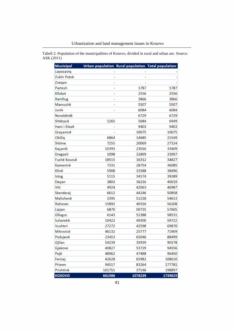
to the bigger ones and, 32 % are classifies as small municipalities. Table 2 shows all
the municipalities in Kosovo and their total population. Those who have missing
values are municipalities that have disagreed cooperation with authorities of Kosovo.
These municipalities have the majority of the inhabitants Serbian and rule themselves
as they were a part of Serbia.
Following a map of Kosovo, figure 4 will be presented including the municipalities
and also the regions distribution. The map has been revised to clarify regional
borders.
37
Nobelprize (2008) 38
Öberg (2008)

Urbanization and land management issues in Kosovo
40
Figure 4: Map of Kosovo’s municipalities and the regional
borders. Source: ASK (2011)
Urbanization and land management issues in Kosovo
41
Tabell 2: Population of the municipalities of Kosovo, divided in rural and urban are. Source:
ASK (2011)

Urbanization and land management issues in Kosovo
42
Figure 5: Planning system of Kosovo
4.2 Planning system
4.2.1 Planes on central level
Spatial planning of Kosovo The spatial planning in Kosovo is made at a central level and identifies in spatial
aspects social, economic and environment development. The spatial planning work is
controlled by “The law for spatial planning, No. 04/L-174” (alb. Ligji për
planifikimin hapësinore, Ligji Nr. 04/L-174). The target for this law, is to ensure a
sustainable and balanced development for the spatial planning of the whole Kosovo
territory. The territory of Kosovo, should in this law be considered as a general value
for the nation, through a good government, appropriate using of the land and also
through environmental protection and cultural and natural heritage39
.
The spatial planning map is created in two levels; the central level with planning
documents on spatial planning of the whole Kosovo territory, i.e., a zonal map for the
whole territory of Kosovo, and spatial planning for specific places. The responsible
entities for this level, is firstly the assembly of Kosovo who has overall and legislative
responsibility. Thereafter the government of Kosovo has the operative responsibility,
and at least the implementation and monitoring by the ministry (Ministry for
environment and special planning, MMPH). The second level of planning is on local
level and contains planning for every municipal territory. This local work includes the
planning for development, the zone map and the detailed regulatory plan. The
responsible entity in this level is the municipal assembly, and in second places the
department in the municipal which is responsible for spatial planning and
management40
.
The spatial planning should according to the law review and evaluate the existing
conditions of demographic data of the country, existing technical, public and social
infrastructure of the central level in relation with the strategic development plan. Also
it should evaluate risks and existing conditions of nature disasters, pollution and
39
Law No. 04/L-174 40
Law No. 04/L-174, Article 5-6
Urbanization and land management issues in Kosovo
43
protected surfaces, special zones and special zones with special protection. The
operative responsibility for this to be implemented is at government level41
.
The focus of spatial planning is to secure a rational regulation of an area, to
harmonize the use of an area and other urban places for building and other purpose
for economic, social, scientific, and cultural development42
.
Kosovo approved its first spatial planning map for its territory in 1978. By this time,
Kosovo was autonomy within the Republic of Yugoslavia. This planning project was
made for the timeframe of 1975 until 200043
. As mentioned before, the war ended
1999 and a new era for the Kosovars begins after 1999. The new spatial planning,
which should be made for the timeframe of 2000 and onwards, turned out not being
easy for the Kosovars. This work should be based on the political, economic and
social situation in the country at that time. It was crucial for the Kosovars to draw a
new spatial plan as fast as they could, to guide the land use for some years. Without
it, and in association with the situation at that time, Kosovo not only lost initiative for
investment but also let the people handle their own land as they wanted. Other
available plans were not useful anymore. Missing plans, especially plans for the urban
zones, resulted in increasing unplanned buildings, property issues, buildings on
agriculture land, and destruction of environment. To minimize such problems,
MMPH together with the local levels handled the situation by working out emergency
plans, to give some directions of how the spatial planning could be developed.
The spatial planning can be compared to the Swedish “regionplan”. One difference is
that spatial planning in Kosovo is made for the whole territory of Kosovo, while the
“regionplan” is made individually for each region in Sweden. On the other hand,
Kosovo is as big as a region in Sweden (comparable with region Skåne).
The Zonal map of Kosovo The zonal map of Kosovo is a map which should define the land use in the country. It
became a part of the legislation and development plan of the spatial planning in
Kosovo after the war, more specific in 2004. The document determine the type,
destination, planned use of space and action measures which are based on available
public and private investments, for the entire territory of Kosovo. The map should be
developed for a period of at least eight years.
The Zonal map is based on a vision, principal and goals in the strategical
development sector. Furthermore it describes the idea to create good living
41
Law No. 04/L-174, Article 12 42 Ministira e Mjedisit dhe Planifikimit Hapësinor (2002) 43
Ibid
Urbanization and land management issues in Kosovo
44
conditions, equal opportunity for good economy and protection of environment and
natural heritage, also cultural and archaeological places.
A zonal map determines actions for:
Economic development
Development in zones for agricultural, residential, commercial, industrial,
construction conditions and also places for mixed use.
Improvement of technical, public and social infrastructure in a central level
Improvement of public security in a central level
Protection from natural disasters and also environment contamination and
degradation.
Reduce and minimize risks from natural disasters and other disaster
Protected surfaces, special zones and protected special zones
Provisions for its implementation and monitoring the implementation44
.
The Zonal map has not been developed by the Ministry of environment and spatial
planning yet. Neither is there any example of how such a map could look like.
Compareably, it is a quite general map and could be comparable with the Swedish
“Översiktsplan” but in larger scale and with more specific rules and details. The zonal
map should be available at both the central level, for the whole country, and at the
local level, for every municipal in the country.
Spatial planning for special places in Kosovo The spatial plan for special zones assume from the zones which are identified in The
Spatial planning map and in the Zoning map mentioned earlier. These planning maps
for special zones have special features and require specific organization,
development, use and protection regime. Such areas include national parks, other
areas with unique nature value, economic value and value of mineral, agricultural and
cultural heritage value. A zone in this case is assumed to be an area. All maps are
based on general laws and specific provisions.
The Spatial Plans for Special Zones define visions, principles and goals of sectoral
strategic development, surface and measures of economic development. Furthermore,
they include development of agricultural areas, residential, commercial, industrial,
technological, mixed land use and terms of condition for construction. The goals of
Spatial Plans for Special Zones also include the development of technical, public and
social infrastructure, protection from natural disasters and other disasters as well as
44 Law No. 04/L-174, Article 13

Urbanization and land management issues in Kosovo
45
rules concerning environmental pollution and degradation. Enforcement provisions
and monitoring are defined to guarantee the implementation.
The spatial plans for special zones are based on ideas for creating better living
conditions, equal economic opportunities and protection of environment as well as
natural and cultural heritage. They are also based on objectives of strategic
development plans of different sectors of the government, public administration,
education, science and technology, agriculture, forestry, rural development, public
safety, cultural heritage, cultural events, sports, environment, social welfare, health,
infrastructure, economy, trade, industry, telecommunications, public transport,
electricity generation and thermal energy, natural resources and minerals, etc. This is
defined in the law no. 04L-174, Article 14 (alb. Neni14).
The Spatial plan for special zones also applies international principles of spatial
planning, sustainable development and governance in harmony with EU norms.
The Spatial planes for special zones at the central level, shall as any other plan, be in
accordance with the Spatial Plan of Kosovo and Zoning Map of Kosovo for a period
of at least eight years. For the design, implementation and monitoring of the Spatial
Plans for special zones, the Government shall by a sub-legal act determine the
classification, duties, responsibilities and content of elements and requirements
needed45
.
4.2.2 Plans on local level
Municipal development plan The Municipal development plan is a multi-sectoral document which defines long-
term goals in economic, social and spatial development. This plan shall include the
development of the urban and rural zones within a period of eight years. To define
sustainable priorities, the development plan assesses and reviews the existed situation
of:
1. Municipal demographic data
2. Utilization of economic development resources in relation to the objectives of
the strategic development plan for both the municipal- and government
sectors;
3. Existing technical infrastructure of central and local level, in relation to the
objectives of strategic development plans of the government and municipal
sectors;
45
Law No. 04/L-174, Article 14
Urbanization and land management issues in Kosovo
46
4. Existing social infrastructure of central and local level, in relation to the
objectives of strategic development plans of the government and municipal
sectors;
5. Protection against natural- and other disasters, but also pollution and
degradation of environment.
6. Development of tourism and protection of cultural heritage
7. Informal settlements46
.
The municipal development plan sets out the vision, guiding principle, objectives and
priorities on which the drafting of Municipal Zoning map is based on. The elements
and basis requirements for the drafting, implementation and monitoring of the plan,
are determined by the sub-legal ministry47
.
Prior the approval of the municipal development plan from the municipal assembly,
the proposal of the plan should be sent to the Ministry of Environment and Spatial
Planning (alb. MMPH). The purpose is a central control of the harmonization of the
map to the Spatial planning of Kosovo and the Spatial planning for special places in
Kosovo.
Municipal Zoning map The municipal zoning plan is a multi-sectoral document, which through graphics,
photos, maps and text defines in detail the type, destination, planed use of a space and
actions which are based on implementation time and justifiable projections for public
and private investments for the whole territory of the municipality. The map has a
duration of at least eight years.
Municipal zoning map defines the areas and measures of:
1. Economic development
2. Development of agricultural area, residential, commercial, industrial,
technological and mixed use, and construction conditions
3. Improving technical infrastructure at local level
4. Improving public infrastructure at local level
5. Improving of social infrastructure at local level
6. Improving public safety
7. Protection against natural and other disasters and pollution and degradation
environment
8. Development of tourism and protection of cultural heritage
46. 39
Law No. 04/L-174, Article 15
Urbanization and land management issues in Kosovo
47
9. Manage informal settlements
10. Enforcement provisions
11. Monitoring of enforcement provisions
The municipal zoning map is based on:
1. Objectives of the strategic development plans of different municipal and
governmental sectors of public administration, education, science and
technology, agriculture, forestry, rural development, public safety, cultural
heritage, cultural events, sport, environment, social welfare, health,
infrastructure, economy, trade, industry, telecommunications, public
transport, distribution of electricity and thermal energy.
2. Sustainable development by using public funds effectively
3. Manage informal settlements
4. Zonal map of Kosovo, the municipal development plan and technical norms
of spatial planning.
The Ministry is by regulations responsible to specify the elements and basic
requirements that are needed to design, implement and monitor the municipal zoning
map through regulations48
.
Detailed regulation plans Depending on the needs for spatial planning, the municipalities can choose to prepare
detailed regulation plans for all or any of the areas specified in municipal
development plan and municipal zoning map.
The detailed regulatory plan determines the conditions for regulation of both urban
and rural zones, as they are defined in the municipal development plan and municipal
zoning map. This plan also determines the conditions for constructions.
The municipalities can chose to develop the plan by themselves, or by procurement to
planning consultant. The model of contracting is defined by the law no. 04/L-42,
Public Procurement in Kosovo.
The municipality submits the draft plan to public interest groups and other
government departments and agencies to public consultations. The consultation
period is maximum 30 days. After this period, the municipality has 30 more days to
review, analyse and incorporate the proposals at the public consultation, and then
submit the plan to the municipal assembly for approval.
48
Law 04/L-174 article 16

Urbanization and land management issues in Kosovo
48
Figure 6: Illegal Buildings. Source:
MMPH (2013)
For the detailed regulation plan to be valid, it has to be in accordance with the
conditions of municipal development plan and municipal zoning plan. If necessary,
the detailed regulation plan can be changed every fifth year, otherwise the detailed
regulation plan covers a period of at least eight years.
4.3 The process of changing the land type One of the main problems in handling the land use development is the change of land
type. Kosovo is in the process of developing its cities by mostly new constructions
but also rebuilding the old ones. Many buildings are developed in existing urban
zones, while other buildings develop new urban areas. It is important that the land is
used in the right way, which should be according to the Kosovo’s spatial plan and in
agreement with the municipality plans, and national interest of sustainable economy
and society. This means using your own land as you desire, is not always the most
optimal decision for the society.
Changing the land use often or always goes from rural to urban. In order to protect
agricultural potential and rational use of agricultural land, there are determined
criteria for classification of agricultural land. The rural land is classified in a scale of
1-8 by its value of utilization and fertility. The land type classified from 1 to 4 is
defined only for agricultural purpose. Classification 5 and 6 is also defined as
agricultural use, but exceptionally even as land with other purposes. The last
classifications, 7 and 8 is defined as agricultural land which may be used also for
other purposes. The land classified 1-4 and 5-6 can be used for other destinations only
if there are no other options and when it is about the public interest49
. At this point,
there must be a spatial plan and a development plan of the municipality for the
specific area. Changing the land use of agricultural land of classification 7-8, can be
done with the urban consent, only if it doesn’t based on the spatial planning. Urban
consent is made by the competent authority for the spatial planning in compliance
with consent Municipal competent body for agriculture. 50
These criteria are based on the Law No. 02/L-26
for agricultural land and are the formal way of
changing the land use. There is also an informal
way, a practical way of changing the land use.
By building illegal buildings, the change of land
use will become without going through criteria
according to the law.
49
Law No. 02/L-26, Article 10 50
Law No. 02/L-26, Article 11

Urbanization and land management issues in Kosovo
49
The illegal buildings are one of Kosovo’s current problems in the spatial planning, in
both urban areas and rural areas. The urban areas are more affected than rural areas.
After the war in 1999, there was a period when the institutions did not prioritize
urbanism and spatial planning. They made emergency plans only for individuals to
build their own home. By this it is clear that the municipal institutions did not
interrupt buildings under construction during a quite long period after the war. Almost
until Kosovo’s independence, they did not seem to consider this seriously because of
the uncertain status of state of Kosovo. During this period the private sector could
build their homes without permission, and larger companies could also be part of a
system, in parallel to the formal system.
In absence of useful law or system, many buildings, both smaller and bigger
buildings, were built all over Kosovo. Both in urban and rural places there were and
are still buildings that are developed without any respect of spatial planning or type of
land use.
It is of course a contradiction that buildings in areas without spatial plan when being
built can’t be illegal because of available spatial plans produced afterwards, but it still
it needs a building permit from the municipal office.
To process illegal buildings and prevent them to continue growing, the state has
through the Ministry of Environment and Spatial planning of Kosovo introduced a
new law and developed temporary measures that should handle the illegal buildings.
The purpose of this law, Law No. 04/L-188, is to give the owners of the illegal
buildings the opportunity to legalize them. By this, the buildings will be approved
according to the standards of health and safety and the municipality will be able to
plan the growth of the city better.
The law for managing the illegal buildings gained legal force in 5th February 2014
and is valid for three years, until 5th February 2017. A preparatory work for this law
was done by taking orthophotos covering the territory of Kosovo from 30 august
2013. This means that illegal buildings that don’t exist on the orthophotos, obviously
have begun their building after the 30 august 2013 and will not be handled by this
law. The process of legalization begins with the law becoming valid. The period of
registering illegal buildings was from 5th February 2014 and a year ahead. This period
gives the owner of the illegal buildings the opportunity to register its building by the
municipal and which further will be registered in the state register of illegal buildings.
Only buildings included in the state registered of illegal building will have the
opportunity to legalize their buildings if they apply. Application for legalization had a
period from 16 September 2015 until 15 March of 2016. All registered buildings will
be processed until February 2017, when the law becomes invalid. Buildings not
fulfilling the requirements for legalization, will be demolished. Figures 7a and 7b
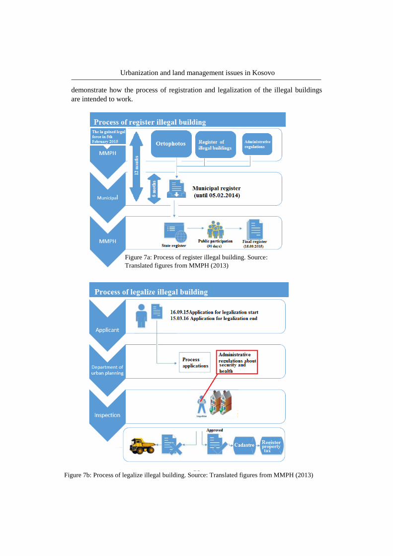
Urbanization and land management issues in Kosovo
50
Figure 7a: Process of register illegal building. Source:
Translated figures from MMPH (2013)
Figure 7b: Process of legalize illegal building. Source: Translated figures from MMPH (2013)
demonstrate how the process of registration and legalization of the illegal buildings
are intended to work.

Urbanization and land management issues in Kosovo
51
As written in the manual for legalization of illegal building in Kosovo, buildings that
will not be legalized according to this law are the following cases:
If the illegal construction was made after the entry to force of the Law of
illegal constructions and it is not identified on a digital orthographical map.
It is built on public property, namely in the area of public interest, in
accordance with applicable laws.
It was built on the area of protected nature and national parks.
It was built on the corridors of infrastructure in the fields of energy, transport
and hydraulic systems.
It was built on protected areas and special areas of cultural heritage.
It was built on agricultural land below irrigation and land consolidation.
It was built on an area with flood risk
It was built on beds or river banks.
It was built on the areas of geological risk, weeping-slide, and defined on the
basis of analyses and professional studies.
If construction exceeds the level of environmental pollution defined in
legislation51
.
Buildings which are unfinished will be included on the list for demolition. Illegal
buildings which were built after the 30 august 2013 will not be legalized according to
this law or any other law. They shall be demolished52
.
4.4 The Kosovo Cadastral Agency The Kosovo Cadastral Agency, KCA is a government authority established by UN-
Habitat in 2000. KCA works under the Ministry of Environment and Spatial Planning
and is the highest authority for cadastre, geodesy and cartography in Kosovo. It
handles and maintains the cadastral database which includes the property records,
mapping and geographic information system (GIS). Furthermore KCA is the central
authority for infrastructure and the geospatial data. The work, responsibilities, rights
and mandates, are regulated by the Law for Cadastre, Law No. 04/-L01353
.
The founding of KCA started during a programme in Kosovo in 2000-2003, which
purpose was to develop and manage the registration of cadastral and land at the
central level. This programme was helped financially by Sweden, Norway and
Switzerland54
.
51
MMPH (2013) s.14 52
Law No. 04/L-188, Article 6.5 53
KCA (2016) 54
MMPH (2016)

Urbanization and land management issues in Kosovo
52
KCA have cooperated with the National Swedish Cadastral Agency, Lantmäteriet in
several projects about the property system and the tax administration of Kosovo.
Furthermore they continue cooperating with countries in Balkan. The current project,
Impuls is about harmonize geographical data and, is a project for reaching UN-
directive Inspire (Infrastructure for Spatial Information in Europe)55
.
The KCA offered the help initially to describe the regulation in Kosovo, their work
and the system they used. Furthermore, I became informed about their cooperation
with other countries, specifically Sweden and Lantmäteriet. Their working
environment was similar as any working place in Sweden. The employees work was
related to the education they had, unlike other working places in Kosovo. You also
noticed that respect for the job was in a higher level as usually. I do think cooperation
with different countries, especially in the UN-directive project Inspire, where all
works for the same goals, have made them take more responsibility and their work
more seriously. The Inspire-project goal is establishing an Infrastructure for Spatial
Information in the European Community.
55
Lantmäteriet (2015)
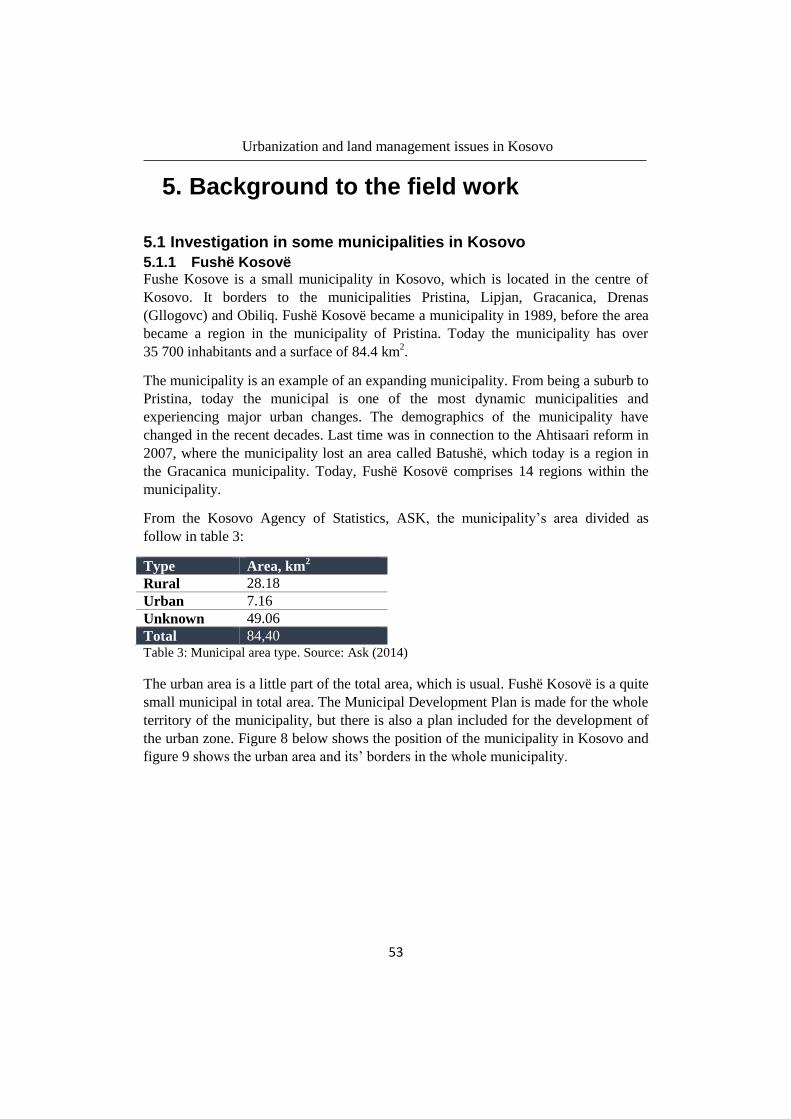
Urbanization and land management issues in Kosovo
53
5. Background to the field work
5.1 Investigation in some municipalities in Kosovo
5.1.1 Fushë Kosovë Fushe Kosove is a small municipality in Kosovo, which is located in the centre of
Kosovo. It borders to the municipalities Pristina, Lipjan, Gracanica, Drenas
(Gllogovc) and Obiliq. Fushë Kosovë became a municipality in 1989, before the area
became a region in the municipality of Pristina. Today the municipality has over
35 700 inhabitants and a surface of 84.4 km2.
The municipality is an example of an expanding municipality. From being a suburb to
Pristina, today the municipal is one of the most dynamic municipalities and
experiencing major urban changes. The demographics of the municipality have
changed in the recent decades. Last time was in connection to the Ahtisaari reform in
2007, where the municipality lost an area called Batushë, which today is a region in
the Gracanica municipality. Today, Fushë Kosovë comprises 14 regions within the
municipality.
From the Kosovo Agency of Statistics, ASK, the municipality’s area divided as
follow in table 3:
Type Area, km2
Rural 28.18
Urban 7.16
Unknown 49.06
Total 84,40 Table 3: Municipal area type. Source: Ask (2014)
The urban area is a little part of the total area, which is usual. Fushë Kosovë is a quite
small municipal in total area. The Municipal Development Plan is made for the whole
territory of the municipality, but there is also a plan included for the development of
the urban zone. Figure 8 below shows the position of the municipality in Kosovo and
figure 9 shows the urban area and its’ borders in the whole municipality.

Urbanization and land management issues in Kosovo
54
The municipal of Fushë Kosovë has developed the Municipal development plan
including the development plan for urban zone (alb. Plani Zhvillimor Urban), which
should be in harmony with the Spatial Plan of Kosovo. The municipality of Fushe
Kosovë is included in the Blue area of the Spatial Plan of Kosovo which vision is to
develop the urban plan, competing with the other municipalities in the same region
and at the same time joined and cooperative, but also it should be attractive to live
and work in them56
. The centre of this Blue area is the capital Pristina. With a distance
of only 8 km from the centre of Pristina to the centre of Fushe Kosovë, the
municipality of Fushë Kosovë has good location for both national and international
economic development.
56
Kuvendi Komunal Fushë Kosovë (2013) p. 6
Figure 8: Municipal of Fushë Kosovë in the
map of Kosovo. Source: Geoportali Shtetëror
(2012)
Figure 9: Urban zone of Fushë Kosovë.
Source: Geoportali Shtetëror (2012)

Urbanization and land management issues in Kosovo
55
Figure 10: The Municipal Development Plan of Fushe Kosovë 2021. Source:
Kuvendi Komunal Fushë Kosovë (2013)
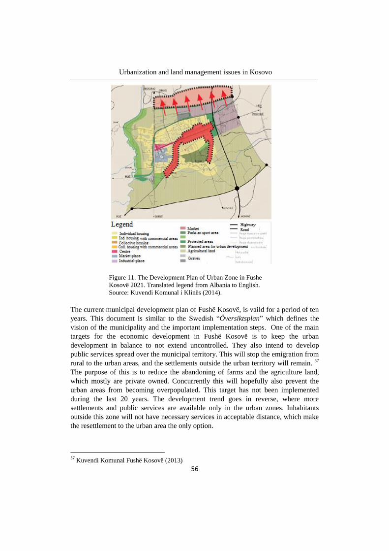
Urbanization and land management issues in Kosovo
56
The current municipal development plan of Fushë Kosovë, is vaild for a period of ten
years. This document is similar to the Swedish “Översiktsplan” which defines the
vision of the municipality and the important implementation steps. One of the main
targets for the economic development in Fushë Kosovë is to keep the urban
development in balance to not extend uncontrolled. They also intend to develop
public services spread over the municipal territory. This will stop the emigration from
rural to the urban areas, and the settlements outside the urban territory will remain. 57
The purpose of this is to reduce the abandoning of farms and the agriculture land,
which mostly are private owned. Concurrently this will hopefully also prevent the
urban areas from becoming overpopulated. This target has not been implemented
during the last 20 years. The development trend goes in reverse, where more
settlements and public services are available only in the urban zones. Inhabitants
outside this zone will not have necessary services in acceptable distance, which make
the resettlement to the urban area the only option.
57
Kuvendi Komunal Fushë Kosovë (2013)
Figure 11: The Development Plan of Urban Zone in Fushe
Kosovë 2021. Translated legend from Albania to English.
Source: Kuvendi Komunal i Klinës (2014).

Urbanization and land management issues in Kosovo
57
The Zonal map which should manage the way of construction and urban development
has not been developed yet. This should help the municipality to manage the old
buildings, but most important to manage the future ones. The reason why this still has
not been developed is because of lacks in both equipment and education, but also
financial hinders.
The municipality of Fushë Kosovë has one of the best agricultural land assets in the
country. About 11 % of the agricultural area is categorized as first level, which means
the best type. This agriculture land is not exploiting the full potential it has for
agricultural production. The interest of cultivating the land reduces among property
owners, because higher profits are given by building constructions. Abandoning of
agricultural land is therefore usual. Considering the trend of building huge
constructions, the municipality is constantly threatened by the demand of land and the
legal process “Changing land use”. 58
5.1.2 Kline The municipality of Klinë was established in 1954 and it is located in western
Kosovo, in the region “The plains of Dukagjin”. It has an area of 309 km2 and a
population of about 39,50059
inhabitants, of which about 8,000 inhabitants live in the
urban area of Klinë. The territory of Klinë is known for having rich natural resources.
It is categorized as forest, qualitative agricultural land, underground resources and
also rich natural and cultural heritage. With the perfect geographic position and a
climate customized for agriculture the development of agricultural land use seems to
be important for the country’s economic development60
. Because of its position, the
municipality of Klinë also has good connection to the highway M9 towards the
capital Prishtina at a distance of 55 km and in the other direction to another big city,
Pejë at a distance of 28 km. Furthermore the municipal also has connection to the
highway M9-1 and the big city of Gjakova. These connections make the municipality
more attractive and give the municipality good conditions for economic development.
How the municipality’s area allocates is showed in table 4 bellow:
Type Area, km2
Rural and other 304.4
Urban 4.461
Total 309 Table 4: Municipal land type. Source: ASK (2014)
58
Kuvendi Komunal i Klinës (2012) p. 14 59
ASK (2011) popullsia 2012-2014 60
Kuvendi Komunal i Klinës (2012) 61
Kuvendi Komunal i Klinës (2014)

Urbanization and land management issues in Kosovo
58
Figure 12 below shows the position of the municipal in Kosovo and figure 13 shows
the urban area and its’ borders in the whole municipality.
The economy of the municipality is based on the agriculture and its products. About
95% of the surface is fertile land and has good potential for agriculture. Most
agriculture-businesses belonged to the municipality before the war, but these areas
have been privatized to a great extent62
.
The urbanization in the municipality, is typical i.e.,
developed along the main street. The urban area is
about 440 ha, whereof 195 ha include built area and
roads. Building along the roads, shows to be more
efficiently since no agriculture can be efficient along
the road. It becomes more efficiently using that land
for urban development. Despite this, the economic
and social developments have had an impact on the
development of the villages in the municipality.
During the last years, the number of people who
worked with agriculture has decreased, but building
62
PZH Kuvendi Komunal i Klinës (2012)
Figure 12: Municipal of Klinë in the
map of Kosovo. Source Geoportali
Shtetëror (2012)
Figure 13: Urban zone of Klinë. Source:
Geoportali Shtetëror (2012)
Figure 14: City of Klina. Source:
Komuna Kline RKS (2016)
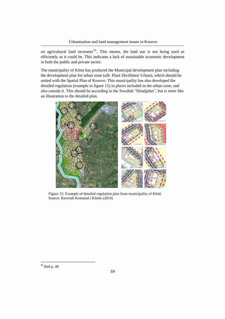
Urbanization and land management issues in Kosovo
59
on agricultural land increases63
. This means, the land use is not being used as
efficiently as it could be. This indicates a lack of sustainable economic development
in both the public and private sector.
The municipality of Kline has produced the Municipal development plan including
the development plan for urban zone (alb. Plani Zhvillimor Urban), which should be
united with the Spatial Plan of Kosovo. This municipality has also developed the
detailed regulation (example in figure 15) in places included in the urban zone, and
also outside it. This should be according to the Swedish “Detaljplan”, but is more like
an illustration to the detailed plan.
63
Ibid p. 49
Figure 15: Example of detailed regulation plan from municipality of Klinë.
Source: Kuvendi Komunal i Klinës (2014)

Urbanization and land management issues in Kosovo
60
5.1.3 Lipjan The municipal of Lipjan is located in the centre of Kosovo, only 17 km to the centre
of the capital Pristina. It has about 58,30064
inhabitants, being about 10,000 urban
inhabitants of Lipjan. The territory of the municipality of Lipjan is about 338.47 km2,
and the urban area is 10.25 km2.
The municipality’s area allocates as followed in table 5:
Type Area, km2
Rural and other 328.22
Urban 10,25
Total 338,47 Table 5: Municipal land type. Source: ASK (2014)
Figure 16 and 17 below shows the position of the municipal in Kosovo and the urban
area and its’ borders in the whole municipality
Figure 17: Urban zone of Klinë. Source:
Geoportali Shtetëror (2012)
The municipal of Lipjan has a mixed land use, and has many different areas to adapt
in the spatial planning. Lipjan have historical and cultural heritage like the marble
cave “Shapella e Gadimes” and the old town Janjeva, zones with special interests etc.
The airport of Pristina, today called Kosovo national airport “Adem Jashari” is
located within the borders of the municipality. About 60 % of the municipal territory
64
ASK-popullsia 2012-2014
Figure 16: Municipal of Lipjan in the map of
Kosovo. Source: Geoportali Shtetëror (2012)
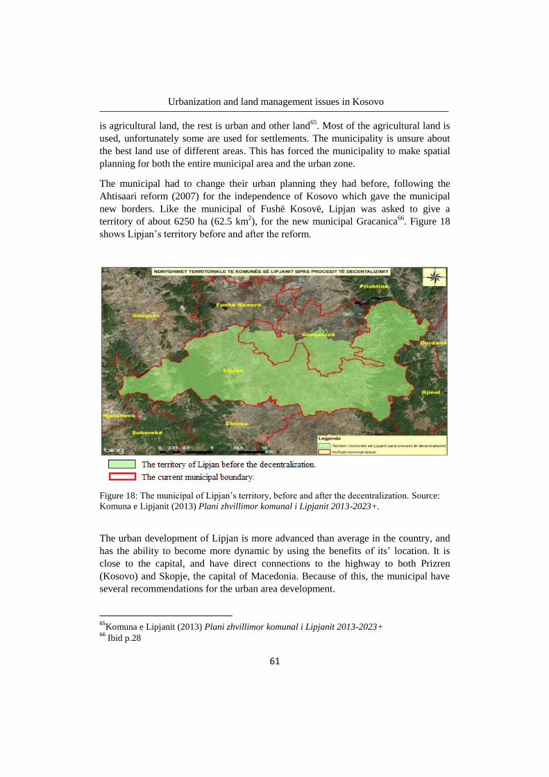
Urbanization and land management issues in Kosovo
61
is agricultural land, the rest is urban and other land65
. Most of the agricultural land is
used, unfortunately some are used for settlements. The municipality is unsure about
the best land use of different areas. This has forced the municipality to make spatial
planning for both the entire municipal area and the urban zone.
The municipal had to change their urban planning they had before, following the
Ahtisaari reform (2007) for the independence of Kosovo which gave the municipal
new borders. Like the municipal of Fushë Kosovë, Lipjan was asked to give a
territory of about 6250 ha (62.5 km2), for the new municipal Gracanica
66. Figure 18
shows Lipjan’s territory before and after the reform.
Figure 18: The municipal of Lipjan’s territory, before and after the decentralization. Source:
Komuna e Lipjanit (2013) Plani zhvillimor komunal i Lipjanit 2013-2023+.
The urban development of Lipjan is more advanced than average in the country, and
has the ability to become more dynamic by using the benefits of its’ location. It is
close to the capital, and have direct connections to the highway to both Prizren
(Kosovo) and Skopje, the capital of Macedonia. Because of this, the municipal have
several recommendations for the urban area development.
65
Komuna e Lipjanit (2013) Plani zhvillimor komunal i Lipjanit 2013-2023+ 66
Ibid p.28

Urbanization and land management issues in Kosovo
62
Figure 19: Land use of the urban territory of Lipjan.
Source: Komuna e Lipjanit (2013) p. 177
The municipality has, developed the Municipal development plan including the
development plan for urban zone (alb. Plani Zhvillimor Urban), which should be in
harmony with the Spatial Plan of Kosovo.
Figure 19 shows how the land use of the urban zone is planned and reported in the
development plan for urban areas. Next figure 20 shows the urban boundary and the
actual urban area.
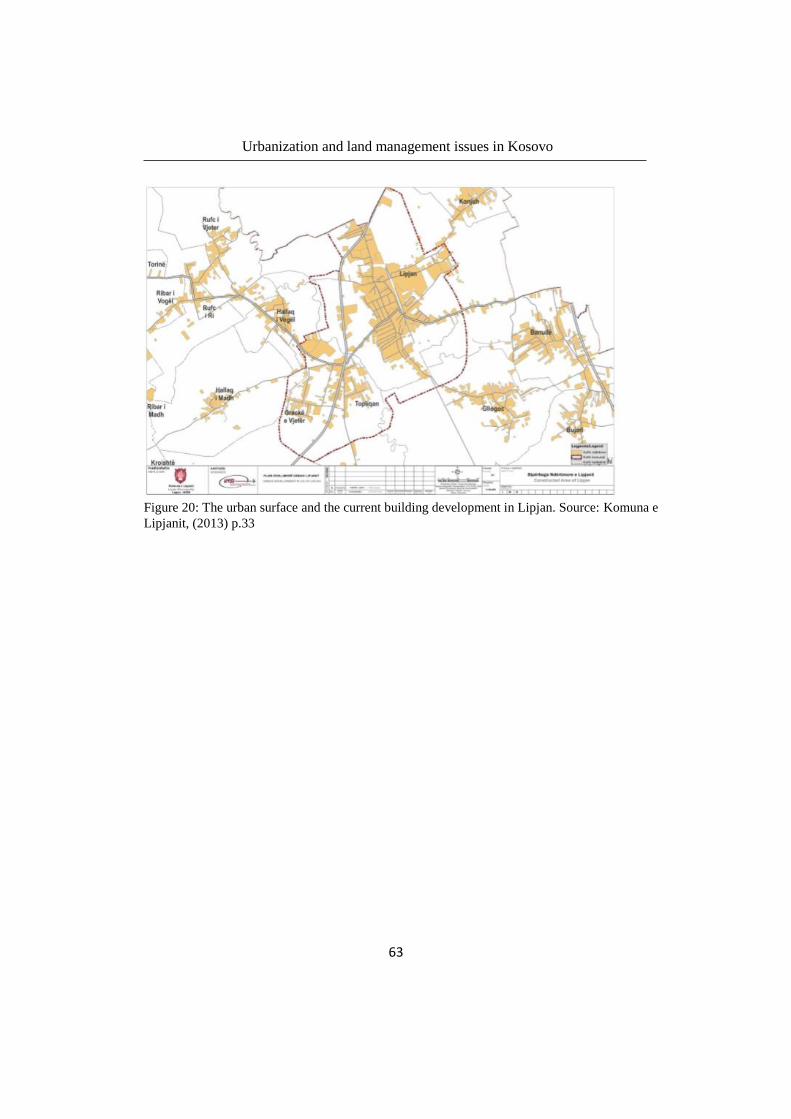
Urbanization and land management issues in Kosovo
63
Figure 20: The urban surface and the current building development in Lipjan. Source: Komuna e
Lipjanit, (2013) p.33

Urbanization and land management issues in Kosovo
64
Figure 21: The urban zone divided into different areas.
Source: Komuna e Lipjanit, (2013) p. 82
Every area of the urban zone is specified more carefully and with building
restrictions. Figure 21 is an example of urban zones, divided in smaller areas, which
in figure 22 is more detailed.

Urbanization and land management issues in Kosovo
65
Figure 22: The planed land use for the area ZUP-3 in the municipal of Lipjan. Source:
Komuna e Lipjanit, (2013) p. 83

Urbanization and land management issues in Kosovo
66
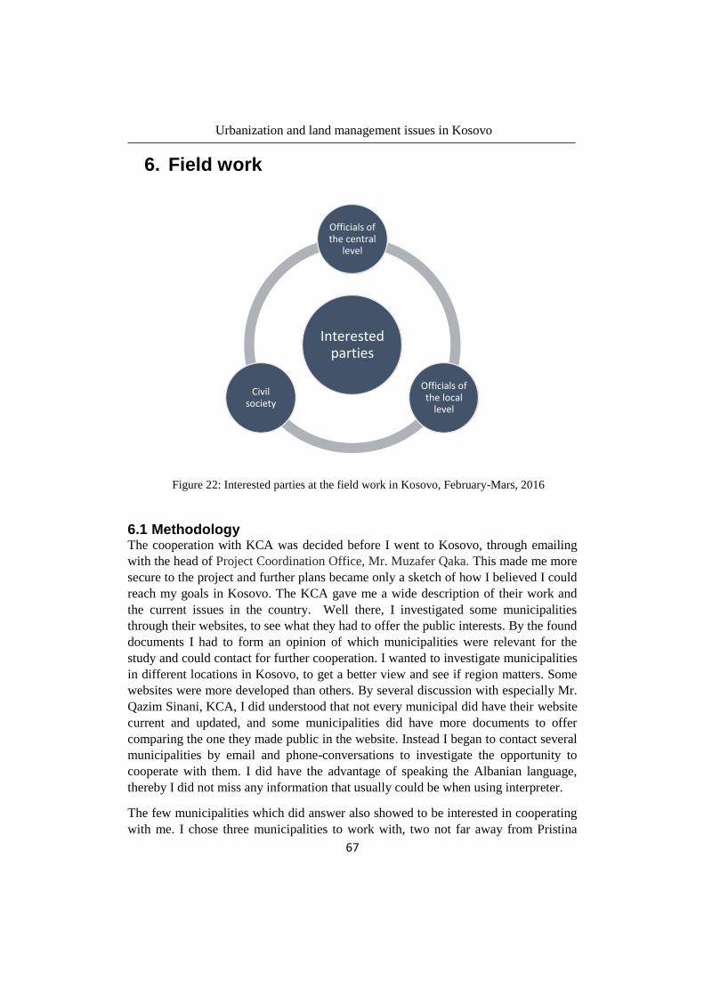
Urbanization and land management issues in Kosovo
67
6. Field work
Figure 22: Interested parties at the field work in Kosovo, February-Mars, 2016
6.1 Methodology The cooperation with KCA was decided before I went to Kosovo, through emailing
with the head of Project Coordination Office, Mr. Muzafer Qaka. This made me more
secure to the project and further plans became only a sketch of how I believed I could
reach my goals in Kosovo. The KCA gave me a wide description of their work and
the current issues in the country. Well there, I investigated some municipalities
through their websites, to see what they had to offer the public interests. By the found
documents I had to form an opinion of which municipalities were relevant for the
study and could contact for further cooperation. I wanted to investigate municipalities
in different locations in Kosovo, to get a better view and see if region matters. Some
websites were more developed than others. By several discussion with especially Mr.
Qazim Sinani, KCA, I did understood that not every municipal did have their website
current and updated, and some municipalities did have more documents to offer
comparing the one they made public in the website. Instead I began to contact several
municipalities by email and phone-conversations to investigate the opportunity to
cooperate with them. I did have the advantage of speaking the Albanian language,
thereby I did not miss any information that usually could be when using interpreter.
The few municipalities which did answer also showed to be interested in cooperating
with me. I chose three municipalities to work with, two not far away from Pristina
Interested parties
Officials of the central
level
Officials of the local
level
Civil society

Urbanization and land management issues in Kosovo
68
and one a bit longer. I had to keep in mind the limited and time consuming
transportation, while choosing municipality. Fushë Kosovë and Lipjan were both two
municipalities near Prishtina but also bordered each other. Still they had different
conditions for development. Fushë Kosovë was a small quite new municipal and
Lipjan was a bigger municipal with older development culture. The municipal of
Klinë was an middle-sized municipal, with average urban development.
Most work was done with the municipal staff, during the normal working hours.
Many meeting with different people from the staff and lots of discussions were made.
All meetings and further investigations was mostly done together with the responsible
for my visiting. It is worth mentioning that many meetings were done in public
environments like cafeterias or even a restaurant, which is very different from the
ordinary meetings in Sweden.
My interviews were from the beginning planned to be formal, but I noticed the
answers were very short and did usually not give me new information. It was mostly
things I already knew and could find in the documents I got. I wanted them to share
what they thought and experienced, not given me learned respond. I changed my
tactics by using unstructured and informal conversations which made the people I
interviewed more relaxed. Of course all the interviews were explicit made aware that
my intent was to know how the urban planning in Kosovo was managed and the any
obstacles which stop the development. Given the fact that it was the end of March and
an early spring was coming; many interviews inevitably ended up in cafés over a cup
of coffee or tea. The interview with the residents was mostly along the road, stopping
different people. It could also be around some outside café along the road, because it
seemed to be the only way they couldn’t escape for the situation. Otherwise there
were many excuses for not wanting to take part in my interviews.
6.2 Interviews
6.2.1 Interviews with inhabitants Interviews with inhabitants were made on the select municipalities and were partially
random selected in the streets. The selection was based on middle aged individuals in
order to eliminate too young people who rarely own something by themselves.
Traditionally, properties or any assets are usually owned by the parents. This type of
selection was made to ensure that the selected individuals have been in contact with
government institutions for land management issues. The interviews where oral and
with purpose to make create discussions. I did have some starting points on the
interviews, but mostly I tried to make a discussion using following questions. The
reason why I chose to ask people in this municipalities, was because I did have
learned more about the urban planning in these municipalities, that any other in
Urbanization and land management issues in Kosovo
69
Kosovo. I could easier relate their answers to the reality and make followed questions
with hope to get even more information. The intention was to:
Get people’s opinion of the urban development and the issues they
experiencing.
Get an idea of their knowledge about urban development and if they respect
the laws for urban planning.
Get peoples opinion about the municipality control.
Find out if there is any interest of investing in urban development in general.
Identify the urban zone by their opinion.
Result of the interviews with inhabitants in municipalities Fushë
Kosovë, Klinë and Lipjan
Total 45 persons were interviewed in the three select municipalities. The middle age
was 46 years old and less than ten were women. Every interviewed person was
interview as long as we had a conversation going. Since many tried to avoid being
interview and returned short answers, I made use of those who were open for question
and asked them more questions. More than half of the interviewed persons were
interviewed less than five minutes. Those who were comfortable with the theme,
could have an interview of about 15 minutes. The longest interview took about 40
minutes, and does not represent the numbered interviews.
It was difficult to make such interviews. My first idea was to see if there was any
possibility I could join any public participation, and thereby question the inhabitants.
Unfortunately it was not possible, since there was no project at that time. I was also
informed by the municipal staff that the residents are those who does not take part of
such meetings. Making a selection was difficult, since the knowledge of urban
development and land management varied a lot. I decided to make the interview
along the street, hoping someone find me interesting. It was hard, many people just
passed me by, other found one excuse after another why they could not answer or
take part of the interview. Some interview which became very short, appears to be
due to the uncertainties. The questions for the inhabitants were mostly the same, but
there were also interviews that diverged from each other. Those interviews I got, can
thereby not be treated as representative for middle aged residents in the
municipalities. They can only present thoughts from people with different experience.
Even though I did not get much information through these interviews, I still could
find some common thoughts.
Generally everyone was positive about the urban development in the municipalities.
Their depictions of the area before and after the war, described a huge transformation
of the cities. One of the current and well discussed issue, which many related to the

Urbanization and land management issues in Kosovo
70
urbanism was just the informal buildings. Less than 10 of the persons who got
interviewed, had applied for building permits and all of them had good experience
from the municipality work. The rest had not applied for building permissions, either
because of they already had permission from the Former Republic of Yugoslavia or
because they seemed not to need one because of their buildings position outside the
urban area. They do see improvements of the administration and legalization of
unformal buildings (chapter 4.4) seems to be appreciated.
The knowledge for urbanism in general appears to be limited. More than half of the
interviews inhabitants refrained from my questions because of insecure and not
knowledge in the study area. Almost all the woman who participated didn’t have
answers and felt uncomfortable when questioned. In tradition girls does not inherits
family assets and neither is it usual for a woman to buy something by herself. Men’s’
are usually the owners and therefore it is the men’s’ job to handle the property
questions. This confirms why many women knowledge about land management
questions were extremely low.
The inhabitant’s thoughts about the municipal regime give a positive picture of the
situation. Everyone seemed to be very satisfied with the municipal work in the urban
area. They expressed sympathetic about the municipalities conditions, and were
confident to say the municipal does their work as good as possible in their
circumstances. Talking about the municipality regime, there was no chance to avoid
the politics. Many answered referring to their political thoughts, which described a
society who acts through its political status.
Among the interviewed people there were three persons who were investors.
According to them, their buildings did have building permissions and were in
accordance with the development plan. They all agreed the municipality have
required every document that should be done according to the law. This gave them
trust and secures the municipality worked and functioned as it should.
The cities in Kosovo were developed along a main way in the municipality. Every
type of business tries to develop and build among the way, the attractive zone. Most
of the interviewed people perceived the urban areas as the zones around the main
way, were business buildings exists, public service, lots of traffic and where buildings
are close to each other.
No one of the interviewed people, except the investors have been in a public
participation meeting regarding new urban plans. These who hadn’t take part in any
participation, didn’t neither know it could affect them. The investors shared all same
experience, very few took part in the public participation. The investors together with
the representatives from the municipality were the only taking part of the public
participation concerning projects they planned to develop themselves.

Urbanization and land management issues in Kosovo
71
6.2.2 Interview with representative from the government An interview with a representative from the government was made possible through a
friend of mine, and also a representative from a political party in Kosovo. I did try to
contact many representatives from Ministry of Spatial Planning and Environment and
the Ministry of Agriculture, Forestry and Rural Development by myself, but with no
respond. It seemed as there was no interest of given someone help without some
service in return. The road to actually meet someone was hard, but if you got the
chance they were able to help you in the best way possible. It was an honour for me to
meet Mr. Agim Radoniqi, vice director of the department of Spatial Planning,
Construction and Housing within the Ministry of Spatial Planning and Environment
of Kosovo. The meeting with Mr. Radoniqi was not a formal interview but a
discussion about urban development and the issues in the country. Mr. Radoniqi
shared a picture of the real situation in Kosovo and his role as a part of the central
level.
The intention to this meeting was to:
Get an opinion of the urban development and the issues they experiencing
form central level.
Get ideas of the central levels view according to knowledge about urban
development and if they respect the laws for urban planning.
Find out the reasons why the Zonal map has not been developed in any
municipality and neither for the whole country.
Find out what the central level have made to reduce the problems in terrain.
Result of the interview with representative from the government
The urban development and its issues was identified by Mr. Radoniqi as uncontrolled
buildings, absence in managing and the displacement of population from rural areas
to urban and also from urban to urban.
The uncontrolled buildings have as mentioned before, existed both before and after
the war, but with a wider development in the rebuilding process. The reason why this
still can be current issue in Kosovo is because of the absence in managing the spatial
planning. Kosovo do have people who have knowledge within the spatial planning
and its system but there is always someone higher in the hierarchy. Mr. Radoniqi
explained this with a joke, telling how the highest in the hierarchy sing a song “I do
whatever I want to”, and express the reason why the management of spatial planning
and using laws and regulations have and continues to fail. There must be someone
who controls the work in every municipal, ensure that deadlines for different types of
tasks are followed. Mr. Radoniqi also thought it is very important for the central to
educate the local level about the management of the spatial planning. His experience

Urbanization and land management issues in Kosovo
72
of the meetings he had have around Kosovo’s municipalities have in general given
him the view of weakness in competence and participation. His advice to the
municipals’ is to widen the cooperation between themselves and the adjacent
municipalities, thereby the development of each municipality could reach sustainable
development and no unnecessary mistakes depending on lack of communication will
be made.
Also the municipalities should give more importance to public participation in every
step of spatial planning and its following plans for land management in urban and
rural development. Through the public participation Mr. Radoniqi’s purpose was to
achieve better understanding of what sustainable development is and how to reach it.
He was quite shore that the Kosovars in general was not competent in urban and rural
development and spatial planning. Neither do they priority spatial planning. But when
public participation becomes a part of the development, the inhabitants will change
their thoughts about traditional land use and instead search for sustainable
development. The difference between the local levels planning and the inhabitants
implementation of the plans will be less and the laws will be more respected.
Mr. Radoniqi also commented the different planning should first be developed in a
central level and further according to the centrals, the locals should develop theirs.
The Zonal map which is a part of the new law from 2004 has not been developed,
neither by the central level or the local level. He believes there is not enough
knowledge among the employee in both central and local level to develop the Zonal
map. In the other side, he believes that cooperation with foreign is not something to
prefer, because it won’t help the situation in terrain. He confirms that foreign
cooperation has helped to develop maps of different kind, but the reality of the terrain
looks different. He also thinks that detailed regulation plans which implement is
selectable for the municipalities, should be mandatory considering the situation in the
country.
6.2.3 Interview with representatives from municipalities Interviews with representatives from municipalities did also happen in unformal way.
Through discussions during the lunch-time or a coffee break were more comfortable.
I had about five different persons who I discussed during the working hours in
connection with the investigation of the municipal work. The accumulate time for
every interview could be about 30 minutes. There was no room for formal interviews.
In general they were very carefully to point some questions could not be answered,
other was just not interested in taking part of formal interviews. It was noticed their
confidence in professional secrecy was not very strong. The unformal interview,
became more relaxed. In the end, I was more satisfied getting something, then
nothing.

Urbanization and land management issues in Kosovo
73
The general concern the municipalities had was lack of knowledge. They were aware
that many hinder for the development-progress toward targets is because of not
having qualified people.
Another concern was the political issue when mandate expires. Every time the
mandate change, there is a “tradition” to make document which earlier mandate have
create invalid. This take the municipality development back to where it begun.
Furthermore there was a representative from a municipal who told me they could not
always reject some application because of threats. It can be a building who should be
ruined, but the municipal authorities will not dare to give such an order. There is no
secure for the employees.

Urbanization and land management issues in Kosovo
74
Urbanization and land management issues in Kosovo
75
7. Analysis of the system of land management and urbanization
From my eight weeks in Kosovo I did see much development and further success in
many part of the Kosovar administration for land management. I also did notice some
weak parts which in long term can be crucial.
First thing I noticed, just from the beginning was how the municipal was managed.
Not in one of the municipalities I visited and cooperated with, did the head of urban
planning have an education correspond to its profession. They did have a staff which
among their terms, did have knowledge to do their work, but not as qualified as they
would be able to improve the situation faster. They do miss work experience, because
everything they do, is the first time. Without help from foreign companies, the
development and structure of administration will take some time. When the head of
any institution is incompetent for its work, I become concern that many decision will
be taken without knowledge for long-term result.
Urban planning has not been something the society in Kosovo has prioritized. There
is week knowledge about the urbanizations’ role and its development. Therefore it is
also difficult for the society to put right people at the right place, because of the lack
in education and profession of urban development. However, the Kosovars are very
open to cooperate with foreign representatives who can help the staff to administrate
the municipalities for further development.
Many collaborators in the municipalities shared a concern which they all experienced
as an obstacle to the development of both the urban planning, but also the whole
municipal administration. When political mandate changes, also the municipal staff
changes and in connection with this all material, plans, documents became invalid.
This happens because of the tension between political parties in the country, which
does not want to accept the other party’s decisions. The development goes backwards
when mandate changes. Some decisions concerning the urban plan can be chosen to
rest until a new political party has the mandate, through which someone’s interest to
do a specific plan or development of the city can be accepted. This can also be
something the inhabitants use if they want to get through a decision or an obstacle
that prevents them to do something. It can be like building permits which have been
rejected or land parcel that has not been approved for changing the land use. Waiting
for a new mandate maybe they are lucky to have contacts in the new mandate which
have the power to do something even if it is against the urban plan and law.
Another problem is illegal buildings and how the municipal manage them. In many
cases they do not tear illegal constructions, even if it is against the urban plan. Many
illegal buildings are private buildings for housing purpose and made in bad
Urbanization and land management issues in Kosovo
76
circumstances, in the acute period after the war. Tear them down will be considered
as destruction of capital which they try to avoid. Instead the municipal try to adapt
current buildings in the development plan with the real situation, in order to simplify
legalization for the illegal buildings.
In one municipal they also shared a concern that sometimes they can’t tear the illegal
constructions even if they consider it is the best solution, because of threats from land
owners. Since there is no justice and security, nobody wants to sacrifice their lives for
a development plan or an illegal building.
Another concern in the urban development in Kosovo was the process of changing the
land use from agriculture land to land with building permit, which gives the
landowners right to build on their land. The law does only prevent changing land use
in high classed agriculture land and in the other classes the law is not as strict. This
makes it very easy to approve the application of changing the land use to land with
building permit, and once it is approved no one can take the right from you. The
government have introduced subsidies for those who work with agricultural to reduce
the desire among the landowners to leave the agricultural work, which can be a step
forward to protect land values and by this trying to manage the land correctly.
In all three municipalities the cities have and continue to build along and very close to
the main street. Their thoughts about building very close to the streets were explained
as a result of limited land within the country. They do consider that 150 meter from
the main street would not be effective and usable for other than buildings, without
including health and environment for the citizens.
The municipals’ maps in and projects/documents were in generally in quite good
quality and had huge explanations about the specific municipal. All three municipals
did have created same maps but with different quality, some was better than others.
Something they all missed, was the Zonal map which nobody had developed yet.
The Zonal map for both Kosovo and municipalities was inserted in the law in 2004.
According to the law the zonal map of Kosovo should be designed and coordinated
nine months after the final approval of the Spatial plan of Kosovo67
. It is the Ministry
of environment and spatial planning’s (alb. MMPH) responsibilities to control the
plans are implemented. The last spatial plan for Kosovo was approved in 2010 and
extends between 2010 and 2020. Neither has the zonal plan of Kosovo or the zonal
plans for the municipalities’ been developed. It has been six years since the last
approved spatial plan and 12 years since the law for zonal maps were introduced and
nothing has happened since then.
During my municipal investigation, I did ask why neither the Zonal map for Kosovo
or for the municipalities were not implemented. As I could investigate, the MMPH
67
Law No. 04/L-174 Article 9, 1.4
Urbanization and land management issues in Kosovo
77
have not developed the Zonal map for Kosovo, which stops the municipalities to do
theirs, since the zonal map for municipalities should be in accordance with the Zonal
map of Kosovo. Despite that some municipals have begun to do their zonal map by
their own, which is against the system. According to the municipalities, the ministry
of environment and spatial planning have confirmed that it is acceptable, and can be a
solution to make the zonal maps for Kosovo since they haven’t done it by themselves.
The staffs at municipalities are concerned about the fact that the zonal map is
developed in the wrong way. The cause is often identified as lack of knowledge and
resources.
The detailed regulation plans have been developed in some municipalities, for
example in Klinë. These plans helps the municipalities to plan the territory in detail,
including regulations for building height, position etc. I think the idea of the detailed
regulation plan is supposed to be like the Swedish “Detaljplan” (eng. Detailed plan)
but it has been developed in an inferior quality. I do think they miss something to
compare with, to realize there could be better developed and include more functions.
The illegal buildings in the country are something every municipal is dealing with.
Some handle them by planning the rest of the city/town matching the illegal
buildings. The government has made it easier for the inhabitants to legalize their
buildings by the temporary law, No. 04/L-188, for illegal buildings. The law has
given the inhabitants the opportunity to legalize their buildings with special rate and
in some cases even free. Result from this process is presented, to show how much
this law has affected the population and the result the municipalities got.
Figure 23 shows how many illegal buildings have been registered in the country
during the timeframe from November 2014, until June 2015. Figure 24 shows
improvements from municipalities using the national database for register illegal
buildings.

Urbanization and land management issues in Kosovo
78
-
50 000
100 000
150 000
200 000
250 000
300 000
350 000
Nov Dec Jan Feb Mar Apr May Jun
Registered illigal buildings
11
16
25
30 30 32 32 32
5
10
15
20
25
30
35
Nov Dec Jan Feb Mar Apr May Jun
Municipalities Using Registry
Figure 24: Municipalities using registry-database for
illegal buildings from November 2014 – June 2015.
Source: MMPH (2015)
Figure 23: Registered illegal buildings in Kosovo from
November 2014-June 2015. Source: MMPH (2015)
Urbanization and land management issues in Kosovo
79
As we see there has been an improvement since the new law has come into force. I do
think that many processes have been improved better if the municipalities had the
government behind their back. The result of the new law, who also did become
implemented, was a good step forward for the urban development continuing to
develop in the right way.
Every municipal in Kosovo, do have urban borders for the urban development. They
often treat this area as the city area, while the rest of the municipality consists of
settlements around farmland. While spoken for a municipality in Kosovo, you usually
refer to the urban area if you only mention the municipality name. If you do want to
make clear it is not about the urban area but a place within the municipality, you
should also mention name of a village which the area includes. The urban area has
usually a development plan for itself, where the municipality specific what the land is
going to be used as. It is quite clear that both inhabitants and the institutions
employees define the urban and non-urban places as two different places that have
two different goals. The created urban border will define the development with the
area, but it is also a border that will separate the societies from each other. If they
manage to use the urban area so they fulfil sustainable development, I do think it will
be more a natural transition between the two areas.
Sustainable development in different parts of the urban areas has been substances in
different projects in Kosovo which has been led by UN-habitat. Specific in Kosovo,
their work has not only been to develop sustainable plans for the urban area, but also
find a common vision between the whole municipality and the local area (urban
border). Furthermore it has been a challenge within the development of communities
to develop sustainable multi-ethnic communities in post-conflict Kosovo.

Urbanization and land management issues in Kosovo
80
Urbanization and land management issues in Kosovo
81
8. Conclusion
Kosovo is a small country, which facilitates the development in the country to
become more efficient. At the same time it is an obstacle, because one have to
manage the scarce available areal in the right way. Every development should be as
sustainable as possible and with the best profit. Kosovo has since the end of the war
been in a process of rebuilding what was destroyed and building what was missing.
Many post-war solutions were acutely done and their traces are still recognizable.
Even before the war, the system of land management was not as developed as in the
western world. The territory of Kosovo had a few small cities where the urban
development was not vey expanded. The biggest cities of Kosovo today, were before
the war smaller and only they who afforded the urban-life lived there. Before the war
people in Kosovo usually lived in villages, working their small area of agricultural
land for a living.
Today Kosovo is not facing a period of creation of different authorities to manage the
country, but of actually implementing the objectives and requirements different
authorities have put for being a functionally country. It is crucial for the country to
develop the cooperation between central and local level, to control the work and to
follow their planning program. The willingness to work and develop the country
should be natural and something the people in Kosovo should pursue. Unfortunately,
at the speed which Kosovo itself currently is developing few things will be
accomplished. Fortunately, many foreign organizations and unions have and continue
to help Kosovo in both education and financing, which will ensure a faster pace.
It was apparent that short-term political interests influence the development of the
country more than it does in Sweden. Cooperation between different parties in
handing over power to a new mandate are non-existant. They should consider each
other’s work and continue working with the past mandates work in order to continue
sustainable development. Additional issues can be related to unfinished deadlines for
projects from the central level, also reflected in the local level working system. The
cooperation between central and local level is necessary and must be improved if
Kosovo want to create sustainable steering systems and a sustainable society.
Despite the deficiencies in governing, I did notice plenty of good work the
municipalities had done to manage their area as sustainably as possible. Different
types of maps, investigations and plans were actually developed in pretty good
quality. Though not good as in Sweden, for natural reasons, they were still often
satisfactory. Also they did have legislations which was relevant and which also
showed some similarities with the Swedish legislations, possibly because of the
Swedish authorities’ influence in the development of Kosovo. It did also have a few
unclear articles in the laws which in practice were both hard to understand and, hence,
Urbanization and land management issues in Kosovo
82
to implement. I did notice that the employees in the municipalities sometimes had
difficulties understanding and implementing the law on their different applications.
This is a point that the municipalities should discuss with the MMPH and suggest
improvements for.
Another difficult situation in trying to manage the land the best way possible was
information and explanation of the developing system for inhabitants. Many have
poor knowledge about the urban system and sometimes even have difficulty to accept
the new regulation system.
The capacity of building is huge. People from everywhere invest in Kosovo.
Residential buildings have been rebuilt and new-builds occur at a speed that now
makes recently sighted buildings destroyed in the war hard to find. Bigger complexes
and companies are built, and the country is in a great development era, much of which
has been financed by families in the diaspora.
The illegal buildings which were built in the acute-time after the war are rarely
destroyed. Instead municipalities try to make them a part of the planning system and
the further development. Destroying homes is both costly for individuals and for the
country.
There are still gaps between what is happening in the reality and the documented
urban plans. If the documents don’t reflect the reality it is hard to analyze where and
how to improve the lacks in the system. As a speaker of the Albanian language I had
the advantage of being able to use the domestic documents, which was beneficial
since many existing documents are not translated into English. Despite the quantity of
documents available in Albanian, not all were of good quality. There were generally
quite few documents about urban development in Kosovo, for both Albanian and
English language. The study is therefore based only on the available documents.
The definition and control of different areas in Kosovo plays a major role in the
development of the urban and rural areas. The country is developing in a variety of
areas; roads, houses, complexes and industries are currently being built. From having
been a country with only very small cities and mainly undeveloped land, today it has
another prospect. Even if drastic changes in the land use have been made, both
inhabitants and institutions are of the opinion that the land use with regards to
agricultural land is doing fine. Almost all agricultural land is being used, and the main
part is being used by the private sector. Therefor investments that are made usually
come from private interests and demands, not governmental. The urban development,
whether legal or not, appears to people as a way for economic rise and modernization
without analyzing what is more efficient in longer perspective.
The identified problems in the urban planning and land management are mainly
connected to the illegal buildings and the process of changing the land use.
Urbanization and land management issues in Kosovo
83
Issues concerning unplanned development are handled first centrally and with
regulations it is applied locally. Central decisions have already been taken about when
and how to handle the illegal constructions, which seem to be an important step in the
right direction. Not many buildings are being destroyed, instead they try to
incorporate them in the current spatial planning, which in general I think is a good
solution. The few buildings that have been destroyed, has been in situations where
other solutions have not been possible or the construction has not fulfilled basic
requirements for security and health. Most of these buildings have been destroyed in
connection with road constructions. Although destruction of these buildings might be
considered destruction of capital in the short sight, it appears profitable in a longer
perspective. Plans, regulations and laws have been developed and are implemented
mostly, but do suffer some lacks. Most plans are made and reach predefined
requirements, but a few are not implemented at all which makes both the central and
local level mismanage the laws and regulations created by them. Besides this, laws
and regulations are not always effective and secure. With the right power and contacts
it can be circumvented by both inhabitants and decision makers. This makes the
situation bad, since a situation where neither of the parts can report mismanaging
transpires because in the end people in every step of the system have been a part of it.
In addition to the socioeconomic losses connected to illegal buildings and the laws of
the country, losses have also been recognizable in other areas. Inefficient managing of
institutions in developments of plans and information of public participation has been
identified. Managing the institutions was perceived difficult and complicated both
from the employees and the inhabitants who have had contact with these institutions.
There exists a lack of knowledge on both sides, which makes the situation as a whole
more difficult and unintelligible. Public participation is an important part of the
urban-rural management theory but is not a big part in reality. Even when
municipalities do invite the public and landowners in meetings that they should take
part in, few usually show up. The importance for the inhabitants to participate does
not seem to have been fully comprehended among the inhabitants. This is something
every municipality in cooperation with the central level should work with. This does
not only concern the public participation as a part of planning, but also includes the
service municipalities should give the inhabitants, to match public needs and services
that municipality’s offer. Knowledgeable inhabitants and, most importantly,
knowledgeable employees in different institutions have better exchange between
them. Laws will be followed, and plans will be developed and at the same time their
work will be understandable and accepted by their inhabitants.
This thesis is mainly related to the planning system and legislation in Kosovo, which
in the conducted investigation, showed to have both positive and negative sides. A
much satisfaction the relatively good regulations, plans and the legislation gave,
deficiencies connected to the government and its governing were disappointing.
Urbanization and land management issues in Kosovo
84
To reach the point of where theory reflect the reality, I believe that cooperation
between the central and local level needs to be further improved. The central level
should control the work municipalities does, and support them with technic help and
knowledge. Also I do think municipalities who border each other should cooperate
more, in order to use all of Kosovo’s territory efficiently and not every municipal for
itself.
Plans and documents included were mostly beneficial. Spatial plans were generally
well done and understandable. The detailed plans were not always as good as
expected, and I do think they have to be improved for them to be able to be optimally
utilized. In comparison with the Swedish detailed plan (swe. detaljplan), the detailed
plan in Kosovo generally contained less information and did not really fulfil the
expectations for a detailed plan – to be detailed. Furthermore I do think it is time for
the government of Kosovo through the Ministry of Environment and Spatial planning
to take responsibility for developing the Zonal map for Kosovo in order for
municipalities to be able do their part. Passivity from the government is also reflected
in the municipalities and their way of managing their work.
In generally every working sector in Kosovo do need some discipline at work. There
are few places where the working hours are respected fully. Since Kosovo is not a
geographically big country, it does have advantageous possibilities to fulfil projects,
in comparison with larger countries in the region. Therefore I believe it is for the best
of the country if everybody could involve themselves in this direction.
Closing words
Finally I want to express a belief which without I think it is harder to reach any goal,
especially if the goal is to build a state. I want to give praise for all the Kosovar
people for the faith, patience, will and joy they carry every day. In hard circumstances
like unemployment and poor finances, they keep faith in improvement and are very
proud of both themselves and the country. My biggest recommendation to all the
Kosovars is to always keep that belief.

Urbanization and land management issues in Kosovo
85

Urbanization and land management issues in Kosovo
86

Urbanization and land management issues in Kosovo
87
9. References
Literature Dukagjini, L., Gjecov, S. and Fox, L. (1989). Kanuni i Leke Dukagjinit. New York:
Gjonlekaj.
Falk, Thomas (1976). Urban Sweden: changes in the distribution of population: the
1960s in focus. Stockholm: The Economic Research institute at the Stockholm School
of Economics.
Government of Kosovo, The Ministry of Environment and Spatial planning (2010)
Plani Hapësinor I Kosovës – Strategjia e zhvillimit Hapësinor 2010-2020+ (Eng.
Spatial Planning of Kosovo). Pristina: Instituti për Planifikimin Hapësinor.
Grant, Jude Garstka (2009) Post-conflict urban planning: The regularization process
of an informal neighbourhood in Kosovo. Oxford, USA: Department of Geography,
The Miami University
O’Sullivan, Arthur (2012). Urban Economics, Eighth Edition.
New York: McGraw-Hill/Irwin.
Pojani, Dorina & Maci, Giulia (2015) The Detriments and Benefits of the Fall of
Planning: The Evolution of Public Space in a Balkan
Post-socialist Capital. Journal of Urban Design, 2015
Potsiou, Chryssy (2012) Policies for formalization of informal development: Recent
experience from southeastern Europe. 2013 Elsevier Ltd.
Simoviq, Dr. Vojisllav (1966). Sistemi komunal dhe politika komunale.
Pristina: University of Prishtina.
Öberg, Martin (2008), Stadskärnehandbok för morgondagen: om konsten att utveckla
attraktiva stadskärnor. Stockholm: Fastighetsägarna

Urbanization and land management issues in Kosovo
88
Online Sources Agjensia e statistikavet të Kosovës, ASK (2014) Struktura e popullsis 2012-2014.
https://askdata.rks-gov.net/PXWeb/pxweb/sq/askdata/?rxid=0b4e087e-8b00-47ba-
b7cf-1ea158040712%2f
[Accessed 2016-05-06]
AMMK-RKS (2009) Shfrytezimi I tokave.
http://www.ammk.rks.net/ballina/toka/Shfrytezimiitokave
[Accessed 2016-04-19]
BBC (2016) Kosovo Profile
http://www.bbc.com/news/world-europe-18328859
[Accessed 2016-03-14]
CIA (2016) The world Factbook.
https://www.cia.gov/library/publications/the-world-factbook/geos/kv.html
[Accessed 2016-05-20].
FIG (2004) Proceedings Geneva
http://www.fig.net/resources/proceedings/2004/2004_comm7_geneva.htm
[Accessed 2016-05-14]
FIG Publication No. 33 (2014) Marrakech declaration: Urban-rural interrelationship
for sustainable development.
http://www.fig.net/resources/publications/figpub/pub33/figpub33.asp
[Accessed 2016-05-30]
Geoportali Shtetëror (2012) Ortofoto, Zonat Urbane
http://geoportal.rks-gov.net/search?municipalityId=9
[Accessed 2016-05-06]
International Federation of Surveyors, FIG (2016) About FIG
http://www.fig.net/about/index.asp
[Accessed 2016-05-17]
Komuna Kline RKS (2016) Picture City of Klina (figure 14)
http://kk.rks-gov.net/kline/City-guide.aspx
{Accessed 2016-05-11]
Kosovo Cadastral Agency, KCA (2016) Agjensia Kadastrale e Kosovës:
Përgjegjësitë. http://www.kca-ks.org/akk
[Accessed 2016-05-11]
Urbanization and land management issues in Kosovo
89
Lantmäteriet (2015) Uppskattad Kosovoinsats
https://www.lantmateriet.se/sv/Nyheter-pa-Lantmateriet/uppskattad-kosovoinsats
[Accessed 2016-05-11]
MMPH (2015) Koncept Documenti për ceshtjen e trajtimit të ndeërtimeve pa leje.
Pristina: MMPH
MFAKS (2015) Republic of Kosovo
http://www.mfa-ks.net/?page=2,121
[Accessed 2016-03-14]
MMPH (2016) Agjensioni Kadastral I Kosovës
http://mmph-rks.org/sq/Agjencioni-Kadastral-i-Kosoves
[Accessed 2016-05-11]
NE (2016) Nationalencyklopedin Landskapslag
http://www.ne.se/uppslagsverk/encyklopedi/l%C3%A5ng/landskapslag
[Accessed 2016-06-21]
Nobelprize (2008) Martti Ahtisaari – Biograohical
https://www.nobelprize.org/nobel_prizes/peace/laureates/2008/ahtisaari-bio.html
[Accessed 2016-06-09]
SIDA (2015) Developments in Kosovo.
http://www.sida.se/English/where-we-work/Europe/Kosovo/Developments-in-
Kosovo/
[Accessed 2016-03-14]
Swedenabroad (2016) Landfakta: Om Kosovo.
http://www.swedenabroad.com/sv-SE/Ambassader/Pristina/Landfakta/Om-Kosovo/
[Accessed 2016-03-20]
Swedenabroad (2016) Landinformation.
http://www.swedenabroad.com/sv-
SE/Ambassader/Pristina/Reseinformation/Reseinformation-Kosovo/
[Accessed 2016-04-09]
UN (2011) UNMIK: Promoting security, stability and respect for human rights in
Kosovo
http://www.un.org/en/peacekeeping/missions/unmik/
[Accessed 2016-03-14]
Valuta (2016) Valutaomvandlare - $US to SEK
http://www.valuta.se/
[Accessed 2016-05-03]
Urbanization and land management issues in Kosovo
90
Wikipedia (2016) Kanuni i Lekë Dukagjinit
https://sq.wikipedia.org/wiki/Kanuni_i_Lek%C3%AB_Dukagjinit
[Accessed 2016-05-02]
Worldbank (2015) FAQs: Global Poverty Line Update
http://www.worldbank.org/en/topic/poverty/brief/global-poverty-line-faq
[Accessed 2016-05-03]
Documents ASK (2011) Regjistrimi I popullsisë, Te dhenat kryesore.
Prishtina: MMPH, Rekos 2011
Komuna e Lipjanit (2013) Plani zhvillimor komunal i Lipjanit 2013-2023+.
Pristina: INSI Sh.p.k
Komuna e Lipjanit (2013) Plani zhvillimor urban i Lipjanit (Ndryshim dhe plotësim)
2013-2018+. Pristina: INSI Sh.p.k
Komuna e Lipjanit (2013) Vlerësimi strategjik mjedisorë; Për planin zhvillimore
komunal te Lipjanit. Prishtina: INSI Sh.p.k
Komuna e Lipjanit (2013) Vlerësimi strategjik mjedisorë; Për planin zhvillimore
urban te Lipjanit. Prishtina: INSI Sh.p.k
Kuvendi Komunal Fushë Kosovë (2004) Profili I situatës urbane të Fushë Kosovës.
Pristina: Urban+.
Kuvendi Komunal Fusheë Kosovë (2013) Plani Zhvillimor Komunal Fushë Kosova
2013-2023. Fushë Kosovë: Grupi ISPE & Adesign
Kuvendi Komunal Fusheë Kosovë (2011) Plani Zhvillimor Urban Fushë Kosova
2021+ REVIDIMI. Fushë Kosovë: Grupi ISPE & Adesign
Kuvendi Komunal i Klinës (2015) Plani rregullus i hollësishëm Klina. Pristina:
Urban+.
Kuvendi Komunal i Klinës (2012) Plani zhvillimore komunal Klinës. Pristina:
Urban+.
Kuvendi Komunal i Klinës (2014) Plani rregullues urban i Klinës. Pristina: Urban+.
Ministira e Mjedisit dhe Planifikimit Hapësinor (2002) Raport mbi gjendjen
ekzistuese në planifikimin dhe menagjimin urban në komunat e Kosovës. Pristina.
MMPH
MMPH (2013) Udhëzues për legalizim; Ndertimer pa Leje. Pristina: MMPH

Urbanization and land management issues in Kosovo
91
MMPH (2015) Koncept Documenti për ceshtjen e trajtimit të ndeërtimeve pa leje.
Pristina: MMPH
Legislative text Law No. 04/L-174
Law No. 04/L-188
Law No. 02/L-26