urbanized mm5 meso-met modeling for the houston texas ozone sip prof. bob bornstein dept. of...
Post on 21-Dec-2015
214 views
TRANSCRIPT

Urbanized MM5 meso-met modeling Urbanized MM5 meso-met modeling
for the Houston Texas ozone SIP for the Houston Texas ozone SIP
Prof. Bob BornsteinProf. Bob BornsteinDept. of MeteorologyDept. of Meteorology
San Jose State UniversitySan Jose State University
San Jose, CA USASan Jose, CA [email protected]
presented atpresented at
Imperial CollegeImperial College
16 March 200516 March 2005

OVERVIEW
MESO-MET URBANIZATIONMESO-MET URBANIZATION FORMULATIONFORMULATION REQUIRED INPUTSREQUIRED INPUTS RESULTSRESULTS
HOUSTON CASE STUDYHOUSTON CASE STUDY DOMAINSDOMAINS GIS INPUTSGIS INPUTS RESULTS RESULTS

From EPA uMM5:
Mason + Martilli: by Dupont
Within Gayno-
Seaman
PBL/TKE scheme
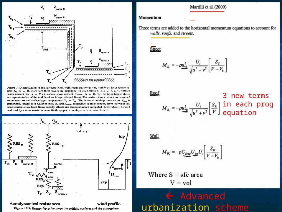
Advanced urbanization
scheme from Masson (2000)
____________________
_________
3 new termsin each progequation

New GIS/RS inputs for uMM5 as f (x, y, z)
land use (38 categories) roughness elements anthropogenic heat as f (t) vegetation and building heights paved-surface fractions drag-force coef for buildings & vegetation building H/W, wall-plan, & impervious-area ratios building frontal, plan, & and rooftop area-densities wall and roof: ε, cρ, α, etc. vegetation: canopies, root zones, stomatal resistances
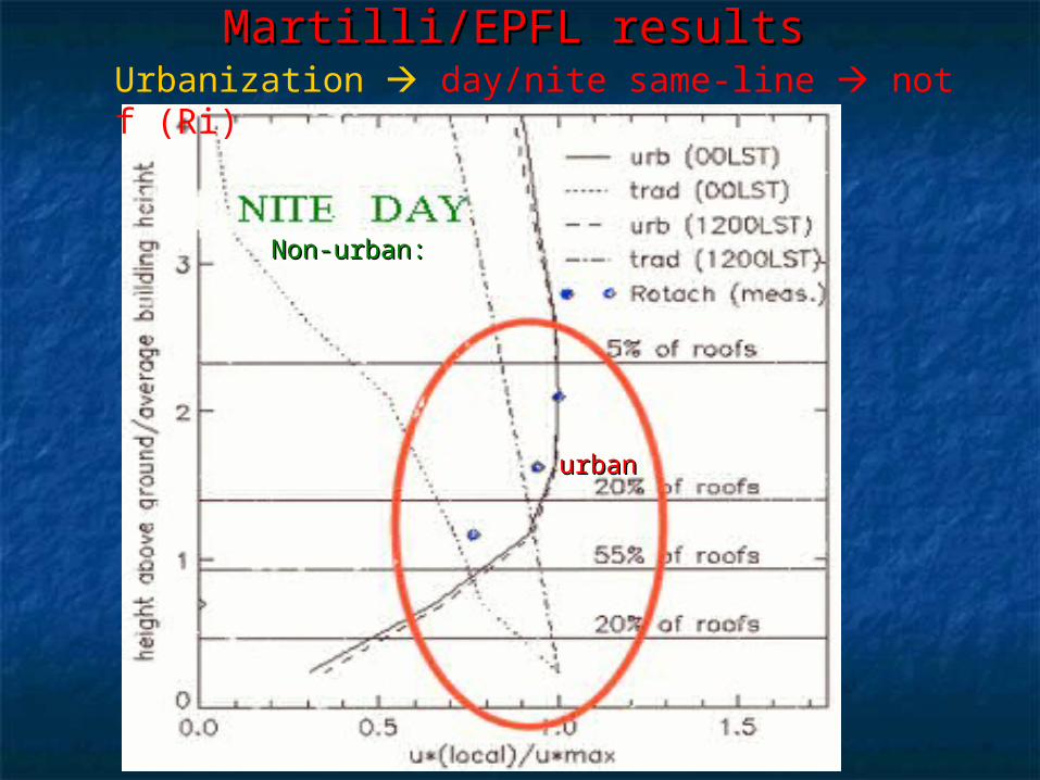
Urbanization day/nite same-line not f (Ri) Martilli/EPFL resultsMartilli/EPFL results
Non-urban:Non-urban:
urbanurban

Current SJSU uMM5 ConfigurationCurrent SJSU uMM5 Configuration
Modified EPA uMM5-96Modified EPA uMM5-96 55 nested-domains nested-domains Inner Inner urbanizedurbanized-domain: 134 x 141, 1-km -domain: 134 x 141, 1-km
grids grids GISGIS/RS sfc-parameters as f(x,y) /RS sfc-parameters as f(x,y)
5-layer 5-layer soil-model; soil-model; Gayno-Seaman Gayno-Seaman TKETKE Simulation: Simulation: 8 days8 days 106 SJSU 106 SJSU clustercluster
1 CPU 1 CPU 15 to 1 15 to 1 96 CPU 96 CPU 0.25 to 10.25 to 1

Domains: 108, 36, 12, 4, 1 kmPts: 43×53×28,55×55×28,100×100×28,136×151×28, 133×141×48

KEY IDEA: IDEAL MESO-MET ATM-MODEL KEY IDEA: IDEAL MESO-MET ATM-MODEL CAPTURES ALL BC FORCINGSCAPTURES ALL BC FORCINGS
OO33 EPISODES OCCUR ON GIVEN DAY: EPISODES OCCUR ON GIVEN DAY: NOTNOT FROM CHANGES IN: TOPO, Q FROM CHANGES IN: TOPO, Q+, OR SFC MESO-, OR SFC MESO-
FORCING (EXCEPT FOG) FORCING (EXCEPT FOG) BUT BUT FROM CHANGES IN UPPER-LEVEL SYN’S, FROM CHANGES IN UPPER-LEVEL SYN’S,
WHICH WHICH ARE FROM ARE FROM EXTERNAL-EXTERNAL-MODEL & MODEL & WHICHWHICH ALTERALTER MESO SFC-FORCINGS (i.e., TOPO, LAND/SEA, MESO SFC-FORCINGS (i.e., TOPO, LAND/SEA,
URBAN) VIA MESO-T AND THUS VURBAN) VIA MESO-T AND THUS V THUS EVALUATE (SEQUENTIALLY):THUS EVALUATE (SEQUENTIALLY):
UPPER LEVELUPPER LEVEL Syn Wx patterns: Syn Wx patterns: pp (via HPGF) & (via HPGF) & then then VV
TOPOGRAPHYTOPOGRAPHY (via grid spacing): channeling of (via grid spacing): channeling of VV MESO SFCMESO SFC: : TT (via Fr/Diff) & then (via Fr/Diff) & then VV

HOUSTON (S. Stetson)HOUSTON (S. Stetson)

3-PM Coastal-L 3-PM Coastal-L Episode day Episode day Domains: 1-3Domains: 1-3
LL
LL
LL

Domain 3, 4 PM:Domain 3, 4 PM: cold-core L: (from SST- cold-core L: (from SST-eddy??) eddy??)
L L

Domain 4 Domain 4 (3 PM) :(3 PM) : L off Houston on L off Houston on OO33 day (25 day (25thth))
LL LL
EpisodeEpisode dayday
LLLL

Urbanized Urbanized D-5D-5: near-sfc 3 PM V, 4-days: near-sfc 3 PM V, 4-days
Max Max OO3dayday

Base-case (current) veg cover (urban min)
Modeled increasedveg cover: urban max values: 0.1 of above

Soil moisture increaseSoil moisture increase for: for: Run 12 (entire area, left) & Run 13 (urban area only, Run 12 (entire area, left) & Run 13 (urban area only,
right)right)
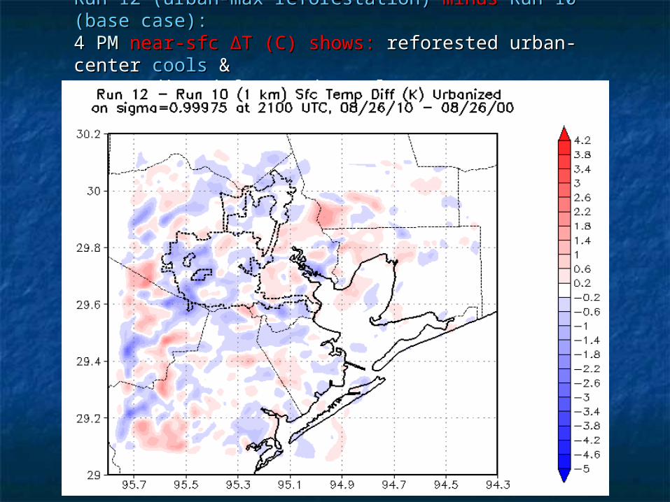
Run 12 (urban-max reforestation) Run 12 (urban-max reforestation) minus minus Run 10 (base Run 10 (base case):case): 4 PM 4 PM near-sfc ∆T (C) shows: near-sfc ∆T (C) shows: reforested urban-center reforested urban-center coolscools & &surrounding deforested rural-areas surrounding deforested rural-areas warmwarm

u1
sea
rur
u2
HOUSTIN-SIP CMAQ-OHOUSTIN-SIP CMAQ-O3:: 6 tree-planting scenarios 6 tree-planting scenarios reduced UHIs (right) in urban-box 1 (left) for Run reduced UHIs (right) in urban-box 1 (left) for Run
1717
Max impactMax impact

ImportanceImportance
urbanizedurbanized MM5 + urban MM5 + urban treetree planting planting
↓ ↓ daytime max-daytime max-UHI UHI ↓ ↓ reduced a/c reduced a/c ↓ precursor ↓ precursor emissionsemissions
& & slower slower atm-chematm-chem ↓ ↓ lower CMAQ-lower CMAQ-ozone ozone EPA EPA emissionemission-reduction SIP credits-reduction SIP credits

The EndThe End