us 16 9 onscreen
TRANSCRIPT

ELISE Knowledge Transfer: Location Interoperability for Digital Transformation, ABCIV-000152-6000184687-REQ-01 EC Joint Research Centre – Unit B6 Rapid Study: Geospatial technology and public participation 28/08/2019
ISA²

© 2019 Deloitte Belgium 2
The EC Joint Research Centre is leading the European Location Interoperability Solutions for E-government (ELISE) Action. ELISE is a package of legal/policy, organisational, semantic and technical interoperability solutions to facilitate efficient and effective electronic cross-border or cross-sector interaction between European public administrations and between them and citizens and businesses, in the domain of location information and services.
ELISE Knowledge Transfer - Location Interoperability for Digital Transformation: To support knowledge transfer and capacity building in the context of location interoperability and digital transformation.
Rapid studies: brief but detailed analysis aimed at generating and sharing knowledge about location interoperability and digital government transformation from both research and practice.
ISA² Action: ELISE
ELISE

© 2019 Deloitte Belgium 3
Thérèse Steenberghen (KU Leuven – SADL)
• Education: MSc in Geography (KU Leuven 1982) – MSc in Biogeography (Texas A&M University 1988) – PhD in Urban and Regional Sciences (Texas A&M University 1992) - Postgraduate degree in business management (Vlerick School Leuven-Ghent 2001)
• Function: Associate professor - Division Geography and Tourism, Managing Director - SADL
• Research interests: spatial analyses in spatial planning, mobility and tourism
• Ongoing projects: GARMON - The Garden monitor, Cartography of gardens by means of teledetection (Belspo, 2017-2019); Citizen Science project ‘MijnTuinlab’ - Crowd sourcing data on garden management and development of learning modules for high schools (EWI, 2019-2021), Framework Contract for the Validation of Innovative Geospatial Tools – New Developments on Imagery and Geospatial Data Processing (SATCEN, 2019); ESPON-MIGRARE Applied research project on the Impacts of Refugee Flows on Territorial Development in Europe (2018-2019); ERASMUS+ - EO4GEO - Towards an innovative strategy for skills development and capacity building in the space geo-information sector supporting Copernicus User Uptake (2019-2021)
• Teaching: KU Leuven Master in Tourism, Master in Urban Planning
About me
Before we start

4
Content of the presentation
• Introduction to the topic
• Systematic review of the scientific literature
• traditional conceptual frameworks for analyzing Geospatial enabled dynamics between governments and citizens
• case studies and good practices around the turn of the century
• Lessons learned from evolution, case studies in
• empowerment through participatory GIS
• co-creation through Citizen-Science
• Synthesis of main messages
• Conclusions
geospatial domain - role of citizen

European Social Security Number (ESSN) under ABC IV © 2019 Deloitte Belgium 5
Introduction to the topic

© 2019 Deloitte Belgium 6
• Need to avoid technological determinism
• Increased complexity: • External actors and their concerns • Co-creation • Rethink and redesign
• Who’s in charge of transforming government? • How to increase their awareness and
understanding of geospatial? • New models of governance and
collaboration
Challenge 1 – (Inter-)Organisational
Pardo & Tayi (2007)
Link with Webinar ‘Role of geospatial in the digital transformation of government’ 07/05/2019

© 2019 Deloitte Belgium 7
The open approach to government will-result in better decisions, and in restoring trust in public
institutions
https://joinup.ec.europa.eu/collection/open-government/about

© 2019 Deloitte Belgium 8
https://ec.europa.eu/isa2/actions/consolidating-and-integrating-reusable-tools-eu-public-participation_en

European Social Security Number (ESSN) under ABC IV © 2019 Deloitte Belgium 9
Systematic review of the scientific literature

10
Castells
Power is not an attribute of individuals and
groups but a relationship
Communication networks are central to the implementation of power-making of any network, such as corporate, financial, cultural-industrial, technology and political networks
The programming of single networks and switching of different networks are the fundamental sources of power. Network programmers (media companies, public institutions, publishers, editors, technicians) and switchers (linking media, cultural, political and financial networks) are the holders of power in the network society
Main concern: empowerment
Key issue: does the use of geospatial technologies lead to greater participation in the political process?

11
[AGILE, 2017]
Public participation no longer the concern it was around the turn of the century?
Same basic concern, other components?
Systematic review of the scientific literature
AGILE Conferences

12
Geospatial enabled dynamics between governments and citizens
Systematic review of the scientific literature
AGILE Conferences
URISA Journal (1989-2017) Special
issues:
- Access and Participation Approaches (2003)
- PPGIS 2012
Web of Science (2000-2019): Keywords: geospatial + democracy 11 articles, 5 retained Relevant issues related to digital transformation of
governments Case studies Open Street Map Keywords: geospatial + citizen science 65 articles + empowerment + democracy 2 articles, 1 retained Citizen Science approached through European Citizen Science Association (ECSA) and JRC @Innovatearth
SWOT
Key issues Evolution of key issues

13
To goods and services To goods and services
as a basis of wealth and power in society
address societal issues such as equity, ownership, and control
Systematic review of the scientific literature

14
PPGIS seek to develop approaches, mechanisms, technologies, and institutions that aid self-determination by various forms of self-defining communities with full awareness of the second view that choices made may have negative as well as positive power ramifications
Characteristics : 1) role of participants in creation and evaluation of data; 2) representation of diverse views, preserving contradiction,
inconsistencies, and disputes against premature resolution; 3) system outputs redefined to reflect the standards and goals of the
participants; 4) capabilities for managing and integrating all data components and
participant contributions from one interface; 5) preservation and representation of the history of its own development
(handling time components); 6) embedment of the condition that “Public Participation GIS” is not
primarily enabling technology focused but is primarily an ongoing “process” of self-determination by self-defining communities
[Onsrud et al, 2003]
Public Participation GIS (PPGIS) +: tools that empower communities - : tools that invasively advantage some people
and organizations while marginalizing others

European Social Security Number (ESSN) under ABC IV © 2019 Deloitte Belgium 15
Traditional conceptual frameworks for analyzing Geospatial enabled dynamics between governments and citizens

16
Techno-optimism and - pessimism assumptions
The public participation ladder (Arnstein, 1969)
[Carver, 2003]
the general public want to be more
closely involved in decision-making, and those in positions of decision-making power actually value and therefore encourage public input
willingness to become actively involved
is lacking across the population as a whole and is symptomatic of a wider malaise in the democratic process; witness the poor turnouts in many elections and the mistrust and contempt in which we hold many politicians
role of geospatial technology in empowerment through participation?
Conceptual frameworks for analyzing Geospatial enabled dynamics between governments and citizens

17
Geospatial technology driven view on participation
Framework for participatory GIS (Rugg, 2003)
[Rugg, 2003]
role of geospatial technology in empowerment trough participation?
Conceptual frameworks for analyzing Geospatial enabled dynamics between governments and citizens

European Social Security Number (ESSN) under ABC IV © 2019 Deloitte Belgium 18
Lessons learned from case studies in 2003

19
Key messages
Specific geospatial concerns: UK
Participation = complex:
5 interrelated components:
1) Issues for consultation
2) Notions of participation
3) Methods
4) Audiences
5) Outcomes (actual and desired)
Citizens tend to have a greater interest in “local” issues and can connect with them more readily
Changing relationships between Access to Information and Public Participation: role of authority (cf Geospatial dimension Role of geospatial in the digital transformation of government)
Best practices, 2003
Evolution citizen driven initiatives by 2019:
- Disappeared
- Were privatised
- Changed beyond recognition
[Smith et al, 2003]
GI context specific:
• democratic problem = who takes the decision, who undergoes the consequences? NIMBY!
• complexity of GI requires GI specialists to support public (≠ neutral)
• helps define and contextualize local issues
Illustration of the context, 2003

20
• Multiple government and non-governmental institutions, positioned at different scales, play an interconnected role in
shaping the processes of participation and of PPGIS production + in digital transformation
• U.S. Department of Housing and Urban Development: the process of citizen participation is essentially being conceptualized at a national scale and then enacted at a local scale, which further adds to the complexity of the local political context and, affects the
PPGIS efforts of (Milwaukee) community organizations coherence among scale levels
• The role of the local political context as an influential factor in the PPGIS process is further complicated by the differential power positions occupied by the various participants. Local government entities hold a more powerful position than the community organizations and have
different modes of participation that the community organizations are compelled to accept if they wish to receive the funding connected to such modes of participation. Use of quota may be in conflict with available resources equity in efforts for organizations and citizens
• Insufficient sharing of inputs, visions, and documents among departments, citizens and community organizations end up either
duplicating the input process (which costs them extra time) or having their input received by only one government agency instead of all
efficiency in use of information in policy making
• Residents input perceived as not really taken in consideration. They felt it was ineffective … acknowledge message from citizens, transparency, communication and feedback
• Influence of culture (power distance, individualism vs collectivism, uncertainty avoidance, …)
The Role of Local Political Context in Enhancing and Limiting PPGIS Production
Cases and good practices, 2003
[Ghose et al, 2003; de Man et al. 2003]

© 2019 Deloitte Belgium 21
STRENGTHS WEAKNESSES GI as a focus for and facilitator of discussions between
stakeholder groups. Ability to handle spatial
information and communicate this to interested
stakeholders; accept, organize and reflect user inputs
during participation process
Incorporate local community level perspectives on a
particular decision problem; local people have more
insights into local phenomena
Citizen empowerment through greater involvement and
openness and accountability on behalf of decision
makers
Marginalization of minority with no or limited access
Bias and errors in judgement influence decision-making
Sense of place? GI data models able to cope with the
quantitative and deterministic aspects of space, spatial
scale and distance, but may not be best suited to
representing the more qualitative and perceptual
effects of place since this is more of a personal
construct
Transparency: how decisions are taken, technical and
budget issues involved, how to get additional
information, …
OPPORTUNITIES THREATS
Support stakeholder dialogue and public involvement in
decision making
More transparency: the decision makers themselves
become more accountable for their actions on the basis
that the decision making process is more transparent
and based on freer dialogue between stakeholders
Citizen more accountable for decisions made by
individual stakeholders and stakeholder groups
receiving greater decision-making responsibility
Potential for misinformation within participatory
systems is quite high, and people need to be able trust
the data and tools they are given if they are to trust the
whole participation process
Mistrust in the wider democratic process: relative
positions of power in respect to different stakeholder
groups within the decision making process remain
[adapted from Carver, 2003] New issues anno 2019?

European Social Security Number (ESSN) under ABC IV © 2019 Deloitte Belgium 22
Lessons learned from evolution, case studies in:
• empowerment through participatory GIS
• co-creation through Citizen-Science

© 2019 Deloitte Belgium 23
Use crowd sourcing for validation of public sector data
Example: OpenCycleMap in The Netherlands matching of Public works data and of the cycling Federation
>> redflagging regions, routes with many inconsistencies
>> identify locations of concern
Good practices:
Liability and data quality
[opencyclemap.org]

© 2019 Deloitte Belgium 24
Use crowd sourcing for enriching data and testing mapping decisions and tools
Example: GARMON project, how can we map gardens?
Good practises:
Liability and data quality
GARMON, The Garden Monitor
© 2019 Deloitte Belgium 25
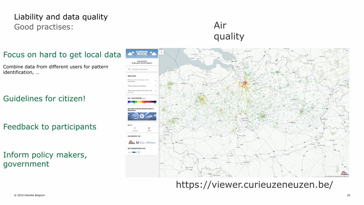
Focus on hard to get local data
Combine data from different users for pattern identification, …
Guidelines for citizen!
Feedback to participants
Inform policy makers, government
Good practises:
Liability and data quality Air quality
https://viewer.curieuzeneuzen.be/

© 2019 Deloitte Belgium 26
Good practices:
Avoid fatigue, stimulate motivation
http://renluftforalle.nilu.no
Stimulate STEM education with learning material, networking, support

© 2019 Deloitte Belgium 27
Good practices: Avoid fatigue, stimulate motivation
Link with events
Humanitarian aid: quick response without policy intervention
Intermediaries replaced by self-organized end users (skilled citizens, professional experts, …)
https://www.gislounge.com/volunteer-to-be-a-digital-humanitarian-mapping/
Importance of skilled end users

© 2019 Deloitte Belgium 28
Good practises: Avoid fatigue, stimulate motivation
UGESCO, UGESCROWD project
Make use of existing events (sensibilisation campaigns, commemorations, …)
or join/create own events
Commemorations
Interoperable, reusable tools!

© 2019 Deloitte Belgium 29
Good practises: Avoid fatigue, stimulate motivation
Gamification, challenges
www.audubon.org

© 2019 Deloitte Belgium 30
Research on what can be publicly accessed
- Make parts of historic movies available (e.g. buildings, landscapes, crowds, …)
- Leave out frames / objects with privacy issues
Good practise: I-Media-Cities
Privacy
https://www.imediacities.eu/
Ontology is not value-free; e.g. it affects what is mapped and by whom!
!

© 2019 Deloitte Belgium 31
Develop geospatial tools for anonymisation through spatial
aggregation (from accident locations to black zones, from ANPR data to flows, ..)
Good practise: Polivisu
Privacy
Open Data
Apps (cycle to school)
Co-create
http://polivisu.eu/

© 2019 Deloitte Belgium 32
Tools for supporting co-creation + access to information
Strengths and opportunities
!
€ € € € €
Manageability
Local time machines
Matthew effect favoring ‘usual suspects’?
https://www.timemachine.eu
• Big data of the past
• A community of communities
• Tools for academics, industry, government, citizen to explore the past
The Venice Time Machine

© 2019 Deloitte Belgium 33
Vandalism and other types of bad edits
Increased threat:
Vandalism in the form of a fake town
https://wiki.openstreetmap.org/wiki/Vandalism
• Copyright infringement
• Disputes within the OpenStreetMap database (edit wars)
• Disputes on the wiki
• Inappropriate use of Bots
• Persistent disruptive behaviour
• Spamming
• Purposeful removal or degradation of data that are known to be correct
• Deliberate adding incorrect data
• Undiscussed imports
Why? For fun? Manipulation? Infiltration?
Response:
• Prevention (clear guidelines)
• Corrections (normal revert, Speedy revert)
• Sanctions (temporary block, permanent ban)

34
Questions concerning viability and usefulness for aiding participatory democracy and decision-making processes at a local level
digital divide + participatory mapping requires basic map literacy skills ( Geospatial
Literacy Geospatial Primer!)
lack of trust among planners and decision makers
in data quality generated by public
participation ( geospatial skills
vocabulary!)
lack of evidence on whether or not Geoweb
methods supporting participatory processes
contribute to sustainable planning decisions
are such methods capable of facilitating a two-
way communication between urban planners
and the participating public?
Depending on the size of the case area and the public resonance of the case, the pilot implementations resulted in varying levels of usage
The difference in participant activity levels is most likely the result of varying target populations (from 5500 to 701,000) and, to lesser degree, areas concerned
[Jankowsky et al. 2019]

European Social Security Number (ESSN) under ABC IV © 2019 Deloitte Belgium 35
Synthesis of main messages

© 2019 Deloitte Belgium 36
STRENGTHS WEAKNESSES
Worldwide PPGIS
Geospatial skills (cf. Geospatial Primer related to
Geospatial Literacy)
Social acceptance =“bundle of dynamic processes”
instead of a set of (fixed) actor positions (Roddis et
al. 2019)
Security, vulnerability to: manipulation, vandalism,
hacking
Participation cultural differences remain
OPPORTUNITIES THREATS
Further technological developments wireless
communication, IoT, …
Inspiring examples of planners and decision
makers relying on data generated by public
Relative positions of power in respect to different
stakeholder groups within the decision making
process remain or are exacerbated
Uncertainties
Research needs: how can geospatial technology support participatory processes + contribute to
sustainable planning decisions?
Communication needs: can geospatial technology facilitate two-way communication between (urban)
planners / decision makers and the participating public?
New issues anno 2019

European Social Security Number (ESSN) under ABC IV © 2019 Deloitte Belgium 37
Conclusion and recommendations

38
Geospatial technology and public participation today is about …
Conclusion

39
• Acknowledge and avoid implicit discrimination, new geospatial technology ≠ value-free (e.g. ontologies)
• Empowerment starts with skills, education and awareness raising is the key (e.g. PPGIS)
• Government as partner in self-organized communities. From participation, to co-creation, to co-evolution
• Further research equity issues related to the massive use of data from varied sources, including citizens and the emerging issues of the application of AI
Recommendations

40
Upcoming: New analytical models to understand interactions citizen <-> policy in citizen science strategies Empowerment: Who, What, How, Why, Where, When? and their effect on democracy

41
Open Questions
• What challenges do public authorities face for participatory activities using geospatial data, technologies, thinking?
• Are there any other examples in this context that you think others could find interesting?
• Are there other issues/aspects we did not touch upon today that you would like to raise or see addressed?

European Social Security Number (ESSN) under ABC IV © 2019 Deloitte Belgium 42
Next steps

43
Rapid Study on Geospatial technology and public participation: collection of feedback for possible use in our Geospatial Primer and Workshop Pack
• Previous Rapid Studies
• The role of geospatial in the digital government transformation
• APIs: benefits and governance models for the public sectors
• Persistent Identifiers (PID)
• Planned Rapid Studies:
• The role of SDIs in the Digital Transformation of Public Administrations (late September)
• Other rapid studies will follow
• What else should we investigate?
https://joinup.ec.europa.eu/collection/elise-european-location-interoperability-solutions-e-government/elise-rapid-studies-and-webinars
ELISE Rapid Studies
Next steps

European Social Security Number (ESSN) under ABC IV © 2019 Deloitte Belgium 44
Key Literature Resources

45
Castells, Manuel (1996, 1997, 1998) The Information Age Trilogy. Vol. I., II, III Cambridge, Massachusetts; Oxford, UK: Blackwell.
Castells, M., (2009) Communication Power. Oxford, New York: Oxford University Press. ISBN 978-0-19-956-701-1
Castells, M., (2012). Networks of Outrage and Hope. Social Movements in the Internet Age. Cambridge, Massachusetts, Polity Press ISBN 978-0-74-566284-8
de Man, E., (2003) Cultural and Institutional Conditions for Using Geographic Information; Access and Participation. URISA Journal Vol. 15, APA I 2003, 29-34
Ghose R. and Elwood, S., (2003). Public Participation GIS and Local Political Context: Propositions and Research Directions. URISA Journal. Vol. 15, APAI pp. 17-24
Harlan J. Onsrud and Max Craglia, (2003). Introduction to the Special Issues on Access and Participatory Approaches in Using Geographic Information. URISA Journal Vol. 15, APA I 2003, 5-7
Jankowski P., Czepkiewicz M., Zwoliński Z., Kaczmarek T., Młodkowski M., Bąkowska-Waldmann E., Mikuła L., Brudka C., Walczak D., (2019) Geoweb Methods for Public Participation in Urban Planning: Selected Cases from Poland. In: Koutsopoulos K., de Miguel González R., Donertpp K. (ed). EUROGEO Book Series; Key challenges in Geography. Geospatial Challenges in the 21st Century. Springer 2019 249-269.
Pundt H. and Toppen F., (2017) 20 Years of AGILE. In Bregt A., Sarjakoski T., van Lammeren R., Rip F. (Editors). Societal Geo-Innovation; Selected Papers of the 20th AGILE Conference on Geographic Information Science. 351-367.Springer. ISSN 1863-2351
Roddis P., Carver S., Dallimer M., Ziv G., (2019) Accounting for taste? Analyzing diverging public support for energy sources in Great Britain. Energy Research and Social Science, 2019
Rugg R., (2003). A Framework for the Use of Geographic Information in Participatory Community Planning and Development. URISA Journal Vol. 15, APA II 2003, 75-80
Smith R. and Massimo C., (2003). Digital Participation and Access to Geographic Information: A Case Study of Local Government in the United Kingdom. URISA Journal. Vol. 15, APAII, 2003, 49-55